28
“Optimal Productivity, Sustainability, Efficiency and Equitability in the use of our Land and Territorial Space”

“Optimal Productivity, Sustainability, Efficiency and Equitability in the use of our Land and Territorial Space”
“Optimal Productivity, Sustainability, Efficiency and Equitability in the use of our Land and Territorial Space”
1. CONTEXT OF THE NATIONAL SPATIAL PLAN
1.0 Overview
The National Spatial Plan (NSP) is Kenya’s first
spatial vision that defines the general trend and
direction of spatial development for the country. It
is a Kenya Vision 2030 flagship project aiming at
distributing the population and activities on the
national space to sustainable socio-economic
development. The Plan envisages to transform the
country into a globally competitive and
prosperous nation, offering a high quality of life
for all citizens in a clean and secure environment
for the next thirty (30) years as envisioned by
Vision 2030.
The Plan addresses the disconnect between
economic and spatial planning that has led to
uncoordinated and unguided development by
establishing a broad physical planning framework
that provides physical planning policies to support
economic and sectoral planning.
The National Spatial Plan further provides a
spatial structure that defines how the national
space is going to be utilized for the realization of
optimal and sustainable use of our land. The Plan
provides a spatial framework upon which the
various sectoral plans and policies will be
anchored and is a basis for preparation of all other
lower level plans.
The Plan covers the entire Kenyan territory and
the Exclusive Economic Zone (EEZ). It is a long
term Plan covering a period of 30 years with 10
year periodical reviews.
1.1 Purpose of the National Spatial Plan
The National Spatial Plan is designed to provide a
national spatial planning framework for
integration of social, economic and environmental
policies. It aims at strengthening national
economic planning by giving spatial dimension to
various national economic sector policies and
coordinating sectoral agencies in order to mitigate
the duplication of functions and responsibilities
and thereby reducing the wastage of Kenya’s
limited resources. The Plan formulates
Physical/Spatial Planning Policies which support
socio-economic and sectoral planning; it finally
serves as a guide in the preparation of regional,
county and local spatial plans.
1.2 Vision of the National Spatial Plan
The NSP envisions spatial development of the
country in a manner that promotes the
competitiveness, prosperity and a high quality of
life for the citizens in line with the aspirations of
Kenya Vision 2030.
1.3 Objectives of the National Spatial
Plan
Specifically, the National Spatial Plan aims at
creating a spatial planning context that enhances
economic efficiency and strengthens Kenya’s
global competitiveness, promoting balanced
regional development for national integration and
cohesion, optimizing utilization of land and
natural resources for sustainable development,

“Optimal Productivity, Sustainability, Efficiency and Equitability in the use of our Land and Territorial Space”
creating livable and functional human settlements
in both urban and rural areas, securing the natural
environment for a high quality of life and
establishing an integrated national transportation
network and infrastructure system.
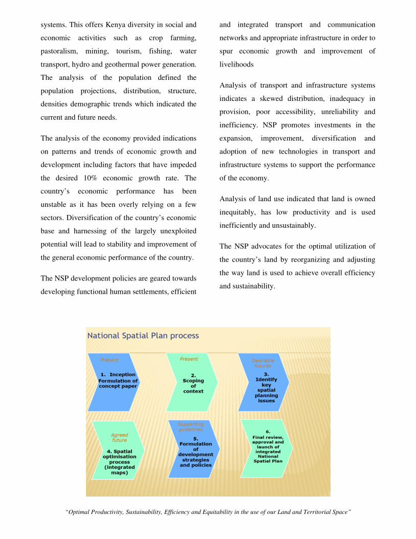
1.4 How the Plan was developed
The National Spatial Planning Process was a
deliberate, systematic and structured action to
develop a broad policy that sets out Kenya’s
vision for spatial development as well as the
specific policies, strategies and measures for
achieving the spatial vision. The preparation of
the NSP entailed an all-inclusive,
multidisciplinary, multi-sectoral and participatory
approach involving views and expert opinions
collected and collated through a structured and
consultative process that brought together
stakeholders drawn from the public, private and
civil society organizations.
The first stage was preparation of a concept paper
that entailed developing a rationale for the Plan,
understanding its purpose and objectives,
determining a methodology for its delivery and
anticipating the resources required for its
preparation. In order to determine the strategic
direction, a rapid scan of the environment was
undertaken to appreciate the spatial issues that
required to be addressed.
Benchmarking was also undertaken to identify
best practices from other countries which
informed and shaped the formulation of the Plan.
In order to capture the long term perspective of
the plan, projections and scenario building was
undertaken. This entailed projections on
population and future scenarios on and its impacts
in relation to urbanization, rural development, use
of land and natural resources, environment and
global trends, among others. Simulations were
done in order to determine the trajectory of
development in various sectors.
To synthesize the findings, a core team
comprising of technical officers drawn from the
Department of Physical Planning and the larger
Ministry of Land and Physical Planning, other
government ministries and agencies and Kenyan
research institutions, under the leadership of the
Director of Physical Planning came up with the
core thematic areas of the plan and formulated
strategies and policies which form the heart of this
Plan. The National Spatial Plan is therefore, a
product of a wide range of collaboration,
consultations and consensus building.
1.5 Principles employed
Effective public participation/engagement, Urban
containment/compact cities, livability, smart and
green urban growth, sustainable development,
Promotion of ecological integrity and promoting
public transportation were the principles that
formed the basis for the formulation of the NSP.

“Optimal Productivity, Sustainability, Efficiency and Equitability in the use of our Land and Territorial Space”
2. PLANNING CONTEXT
The formulation of the NSP was guided and
informed by an analysis of the Constitution,
existing laws and policies. Detailed analysis of
different perspectives and trends of the country
including geographical, population, economy,
transport and infrastructure, human settlements
and land use were undertaken to inform the
development strategies and policies
2.1 Constitutional, Legal and Policy
basis of the National Spatial Plan
The Constitution governs the process and context
of the NSP. It is the supreme law that outlines
national values and principles of governance that
guides all activities including making and
implementing public policy. The supreme law
gives the State powers to regulate the use of any
land and property in the interest of land use
planning. The constitutional function of National
Government is the formulation of general
principles of land planning and coordination of
planning by the counties, therefore, preparation of
the NSP has a constitutional grounding
The analysis of the legal environment informed
the process and content of the NSP. The Physical
Planning Act, 1996 is the primary physical
planning statute which provides for preparation of
various types of physical plans. Others include
County Governments Act, 2012, The Urban Areas
and Cities Act, 2011, Environmental management
and Coordination Amendment Act (2015),
Agriculture, Fisheries and Food Authority Act,
2013, Water Act, 2002, National Land
Commission Act, 2012 and The Land Act, 2012.
Key national and sectoral policies were also
considered during preparation of NSP with a view
of correctly interpreting, translating and giving
them a spatial dimension
The Kenya Vision 2030 is the country’s
development blueprint; it recognizes land reform
as one of the foundations that anchor the three
pillars of the Vision. The Vision identifies the first
National Spatial Plan as one of its flagship project.
This Plan forms the foundation for
implementation of national projects by providing
spatial illustration of projects and identifying a
strategy for land development.
Other policies included, the National Land Policy,
the Agriculture Sector Development Strategy, the
National Housing Policy for Kenya, the ICT
policy, the Industrial Master Plan, the National
Tourism Strategy, the Integrated National
Transport Policy and the National Climate Change
Response Strategy.
2.2 Geographical and Socio Economic
analysis
This analysis provided an appreciation of the
opportunities to leverage on and challenges to be
addressed by strategies and policies
The analysis identified the rich and natural
resource endowment due to the unique
topography, climate, geology and drainage
“Optimal Productivity, Sustainability, Efficiency and Equitability in the use of our Land and Territorial Space”
systems. This offers Kenya diversity in social and
economic activities such as crop farming,
pastoralism, mining, tourism, fishing, water
transport, hydro and geothermal power generation.
The analysis of the population defined the
population projections, distribution, structure,
densities demographic trends which indicated the
current and future needs.
The analysis of the economy provided indications
on patterns and trends of economic growth and
development including factors that have impeded
the desired 10% economic growth rate. The
country’s economic performance has been
unstable as it has been overly relying on a few
sectors. Diversification of the country’s economic
base and harnessing of the largely unexploited
potential will lead to stability and improvement of
the general economic performance of the country.
The NSP development policies are geared towards
developing functional human settlements, efficient
and integrated transport and communication
networks and appropriate infrastructure in order to
spur economic growth and improvement of
livelihoods
Analysis of transport and infrastructure systems
indicates a skewed distribution, inadequacy in
provision, poor accessibility, unreliability and
inefficiency. NSP promotes investments in the
expansion, improvement, diversification and
adoption of new technologies in transport and
infrastructure systems to support the performance
of the economy.
Analysis of land use indicated that land is owned
inequitably, has low productivity and is used
inefficiently and unsustainably.
The NSP advocates for the optimal utilization of
the country’s land by reorganizing and adjusting
the way land is used to achieve overall efficiency
and sustainability.

“Optimal Productivity, Sustainability, Efficiency and Equitability in the use of our Land and Territorial Space”
3. NATIONAL SPATIAL PLAN DEVELOPMENT STRATEGIES
The NSP development strategies are designed to
provide approaches/strategies for spatial growth
and development of the country by addressing
factors that have kept the country from achieving
the intended national goals and objectives. The
strategies are aimed at providing a spatial
expression to Vision 2030 and other sector
policies. The NSP provides development
strategies for managing global impacts,
optimizing the use of land and natural resources,
promoting functional and livable human
settlements, creating regional balance,
transforming rural areas by modernizing
agriculture, integrating national transportation,
ensuring efficient and adequate infrastructure and
conserving the environment.
3.1 Managing Impacts of Global Trends
Kenya’s economy has delayed reaching the
economic take-off stage compared to other global
economies. Kenya Vision 2030 aims at making
the country globally competitive and a choice
destination for investment in the emerging sectors
of Information Communication and Technology
(ICT), niche tourism, knowledge industry and
increase the share of manufacturing and industry
in the Gross Domestic Product (GDP).
The NSP seeks to harness the exploitation of
renewable and green energy sources by
identifying and mapping them and providing the
necessary infrastructure for their tapping. This
will increase the installed energy capacity and
reduce the cost of production and while improving
on quality of goods. The NSP proposes location of
export oriented industrial and manufacturing
activities in Nairobi and Mombasa to leverage on
their existing functional urban systems. Such
activities can also be located in Kisumu, Eldoret,
Nakuru and other emerging high potential urban
centers. This will facilitate harnessing of free
movement of labour and capital.
Further, the NSP seeks to address the housing,
urban facilities, transportation, safety and
infrastructure challenges to encourage knowledge
workers and their families to live and work in
Nairobi and Mombasa primarily and other
complementary growth nodes at county level.
The country will optimize the existing national
potential especially in marginalized regions; this
will ensure a diversified, steady and stable
economy and therefore attract foreign direct
investments to the country.
Adoption of knowledge, technology and
innovation driven economies will enable the
country to upgrade and diversify its existing
industry and business clusters, and shift to
activities with higher innovation and technology
content. Kenya must utilize her rich human
resource base, including in locations such as
Nairobi, Kisumu and Mombasa in order to
embrace and transit to a knowledge, technology
and innovation based economy

“Optimal Productivity, Sustainability, Efficiency and Equitability in the use of our Land and Territorial Space”
3.2 Optimizing Land and Natural
Resources
The NSP allocates land to different activities
rationally by putting into consideration the land
capabilities and potential and by addressing the
concern arising from the need to protect and
conserve the environment.
The strategy identifies and apportions land to
various land based needs including protecting
prime agricultural land, prioritizing grain basket
and export crop areas, tapping the capabilities and
potentials of the ASALs, accommodating urban
growth and provision of adequate land for current
and future development of infrastructure, utilities
and environmental conservation and protection
areas.
3.3 Promoting Balanced Regional
Development
Regional imbalance has been a major issue in
Kenya since independence. Despite the whole
country being endowed with massive resources,
an analysis of the situation reveals massive
disparities between regions. These disparities may
be divided into the North-South divides with other
pockets of divides which are characterized as
urban rural, rural- rural and urban-urban divides.
The NSP proposes establishment of economic
zones in the Northern region according to the
potential, encourage equitable exploitation and
sound management of mineral resources,
promotes investment in sustainable tourism
including eco-tourism, irrigation activities for
improved productivity in quantity and quality of
yield within the potential regions, and promotes
industrialization and value addition through the
provision of support infrastructure in the less
developed regions.
3.4 Promoting Rural Development
The majority of Kenya’s population lives in the
rural areas which are mainly characterized by
subsistence agriculture and high levels of poverty.
According to the World Bank 2015 report,
Kenya’s rural population was 33,362,846 in 2013
representing 75.19% of the total population.
Rural development strategy aims at improving the
quality of life and economic wellbeing of people
living in rural areas through the improvement of
agriculture and allied activities; rural production
units, socio-economic infrastructure, community
services and facilities, tourism, and human
resources in rural areas.
The NSP defines the rural areas by delineating
urban growth limits and conservation areas. The
NSP in this strategy promotes development of
appropriate transport and infrastructural facilities
and services to support the exploitation of the
natural resources in the rural areas as well as the
opportunities they present to spur economic
development, it also promotes rural
industrialization including rural tourism, mining
and agro-based industries.
The Plan promotes large scale commercial
livestock production practices in the transitional
cluster of rural areas and encouraging eco-villages
in the rural areas.

“Optimal Productivity, Sustainability, Efficiency and Equitability in the use of our Land and Territorial Space”
3.5 Urbanization strategy
Kenya is experiencing rapid
urbanization. Statistics indicate that 34.3% of the
population lives in urban areas, it is predicted that
by the year 2030 more than half of the country’s
population will be staying in urban areas.
Urbanization in Kenya has experienced a number
of challenges which this strategy seeks to address.
These challenges include skewed spatial
distribution of urban centres, urban sprawl and
informality in peri-urban fringe, lack of
functional/role specialization, informal
settlements, inadequate and inefficient transport
and infrastructure, inefficient governance
structures and urban poverty. Through this
strategy the NSP proposes promotion of
development centers according to their potential
and population as; local, market, rural, urban and
growth centers, creation of an enabling
environment for commercial and industrial
developers to undertake potential development
within the urban areas, provision of alternative
areas for development of urban centers by
provision of services and infrastructure,
strengthening urban-rural linkages through
provision of integrated transportation and
communication systems.
Further, the strategy advocates for compact
mixed-use development, in-fill development and
redevelopment as well as intensification of
development in the existing urban areas and
controlling direction of urbanization in order to
divert urbanization to less agricultural potential
areas.
Livability of our Urban Areas

“Optimal Productivity, Sustainability, Efficiency and Equitability in the use of our Land and Territorial Space”
4. NATIONAL SPATIAL PLAN POLICIES
4.0 Overview
The purpose of the policies is to provide a firm
base or foundation upon which to spatially anchor
the strategies enumerated in the Plan and to
provide a spatial framework for the
implementation of large scale national projects
enunciated in Kenya Vision 2030.
The Policies are aimed at enhancing global
competitiveness and economic efficiency,
optimizing the use of land and natural resources,
promoting balanced regional development and
conserving the environment.
4.1 National Spatial Structure
The National Spatial Structure proposed by the
NSP creates three broad areas in which the spatial
planning for the country shall be undertaken.
These are informed by agro-climatic zonation and
agricultural potential. These broad areas are the
high agricultural potential, medium agricultural
areas and the range lands.
Policy Statements
I. The National Spatial Plan establishes the
National Spatial Structure as a framework to
achieve integrated and sustainable spatial
development of the country.
II. The National Spatial Plan shall be the basis for
preparation of lower tier development plans to
achieve integrated and sustainable land use
planning and to promote harmony and mutual
cooperation in planning in the country.

“Optimal Productivity, Sustainability, Efficiency and Equitability in the use of our Land and Territorial Space”

“Optimal Productivity, Sustainability, Efficiency and Equitability in the use of our Land and Territorial Space”
4.2 Enhancing National Competitiveness
To enhance the country’s competitiveness Kenya needs to leverage on its strengths and opportunities which
include the existing cities, geographical location, abundant natural resources, existing and proposed
infrastructure projects and emergence of ICT.
Kilifi
National Competitiveness Model
AIR
SEA
AIR
SEA
AI
R
AIR
AIR
AIR
LA
KE
Nairob Kitui
Mombasa
Lamu
Thika
Meru
Mwing
Garissa
Wajir
Lodwa
Moyal
Mandera
Kilifi
Isiolo
Eldoret
Nakuru Kisum
Kakameg
Diani
Kajiad
Machako
Mwatat
Subare

“Optimal Productivity, Sustainability, Efficiency and Equitability in the use of our Land and Territorial Space”
Policy statements
I. Selective concentration concept shall be
adopted for the planning and location of
urban based economic activities in all
counties throughout the country to
leverage on national competitiveness.
II. The major urban areas shall be planned
and provided with appropriate
infrastructure to enhance efficiency and
quality of life.
III. Land and natural resources of the less
developed areas shall be utilized optimally
and sustainably to enhance national
competitiveness
IV. The efficiency of the transportation
network shall be enhanced to take
advantage of the strategic location and
position of the country.
V. The National Spatial Plan encourages
cooperation in spatial and economic
planning with member states of East
African Community (EAC) and Common
Markets of East and Southern Africa
(COMESA)
Modernizing Transportation to improve our National competitiveness

“Optimal Productivity, Sustainability, Efficiency and Equitability in the use of our Land and Territorial Space”
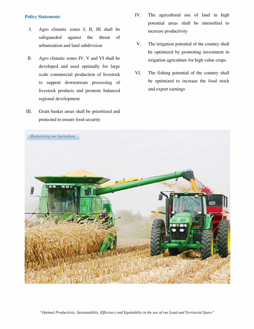
4.2 Modernizing Agriculture
The agriculture sector development strategy aims at transforming agriculture into a modern and
commercially viable sector through identifying areas as per their potential for protection, intensification and
diversification
.
“Optimal Productivity, Sustainability, Efficiency and Equitability in the use of our Land and Territorial Space”
Policy Statements
I. Agro climatic zones I, II, III shall be
safeguarded against the threat of
urbanization and land subdivision
II. Agro climatic zones IV, V and VI shall be
developed and used optimally for large
scale commercial production of livestock
to support downstream processing of
livestock products and promote balanced
regional development
III. Grain basket areas shall be prioritized and
protected to ensure food security
IV. The agricultural use of land in high
potential areas shall be intensified to
increase productivity
V. The irrigation potential of the country shall
be optimized by promoting investment in
irrigation agriculture for high value crops
VI. The fishing potential of the country shall
be optimized to increase the food stock
and export earnings
Modernizing our Agriculture

“Optimal Productivity, Sustainability, Efficiency and Equitability in the use of our Land and Territorial Space”
4.3 Diversifying Tourism
Kenya Vision 2030 identifies tourism as one of the six priority sectors with high potential of spurring the
country’s economic growth and development and achievement of the envisaged 10 percent GDP growth by
2017. These sectors will drive. To develop tourism, NSP identifies five tourism circuits within which to
promote diversification by offering diverse tourism products in each circuit;

“Optimal Productivity, Sustainability, Efficiency and Equitability in the use of our Land and Territorial Space”
Policy statements
I. The NSP shall promote diversification of
tourism by offering diverse products in the
different tourist circuits throughout the
country.
II. Appropriate infrastructure shall be
provided and facilities upgraded
III. Tourist attraction areas and sites shall be
conserved and protected
IV. Appropriate transport infrastructure shall
be provided to link the different tourist
circuits, attraction areas and sites
V. The governance of the tourism sector shall
be enhanced.
VI. Spatial development plans shall be
prepared to guide implementation of the
flagship projects for the tourism sector
Diversifying our Tourism – Beach Conferencing

“Optimal Productivity, Sustainability, Efficiency and Equitability in the use of our Land and Territorial Space”
4.4 Managing Human Settlements
The Kenya Vision 2030 anticipates that more than half of our nation’s population is going to be residing in
urban areas following the current population trends. Thus, Kenya will need to plan for decent and high
quality urban livelihoods for her population. The NSP creates a hierarchy of urban areas as national, regional
and urban growth areas and anticipates the emerging metropolitan areas.

“Optimal Productivity, Sustainability, Efficiency and Equitability in the use of our Land and Territorial Space”
I. The expected increase in population in
urban areas shall be anticipated and
accommodated particularly for the main
growth areas.
II. Nairobi, Mombasa and Kisumu, growth
areas shall be supported to enhance global
competitiveness.
III. Alternative urban areas shall be developed
and supported to promote balanced
regional development and spur growth.
IV. Rural growth centres shall be rationalized
and supported to act as central places and
settlements clustered to free the rich
agricultural land
V. Human settlements shall be developed in
line with environmental and natural
resources conservation to improve living
conditions
VI. The NSP shall advocate for the provision
of an efficient, reliable and effective
transport system for human settlement
VII. The management and governance of
human settlements particularly the urban
areas shall be improved.
Our planned Human Settlements

“Optimal Productivity, Sustainability, Efficiency and Equitability in the use of our Land and Territorial Space”
4.5 Conserving the Natural Environment
The Constitution of Kenya, Article 42 states that every person has the right to a clean and healthy
environment, which includes the right to have the environment protected for the benefit of present and future
generations through legislative and other measures. The NSP identifies the entire country as an
environmentally fragile space and seeks to prioritize protection and conservation of the environmentally
sensitive areas.

“Optimal Productivity, Sustainability, Efficiency and Equitability in the use of our Land and Territorial Space”
NSP Policy statements
I. All environmentally sensitive areas shall
be protected and utilized in a sustainable
manner. These are Wetlands, Marine
Ecosystems, Forest Ecosystems and
Mountain Ecosystems
II. All environmentally fragile areas shall be
conserved and utilized in a sustainable
manner and particularly the ASALs
III. All government agencies shall integrate
environmental concerns in policy
formulation, resource planning and
development processes.
IV. The National Spatial Plan supports the
mainstreaming of climate change into the
national and county planning processes.
4.6 Integrating the National Transportation Network
Vision 2030 aspires for the country to be firmly interconnected through a network of roads, railways, water
ports airports and water ways, and telecommunications. The NSP proposes an integrated national and urban
transport system that seeks to maximize efficiency and sustainability of the transport sector. It identifies the
major national infrastructure routes and proposes new ones to fill the missing links and enhance
connectivity.
Connecting Human Settlements with Transportation system

“Optimal Productivity, Sustainability, Efficiency and Equitability in the use of our Land and Territorial Space”

“Optimal Productivity, Sustainability, Efficiency and Equitability in the use of our Land and Territorial Space”
NSP Policy statements
I. An integration of national transport and
land use planning shall be adopted.
II. The NSP shall support the development of
an integrated and functional transport
system for the national and urban areas.
III. The NSP shall support development of an
efficient and affordable Mass Public
Transport for all urban areas in the country
IV. An urban transport policy that aims at
developing an integrated, balanced and
environmentally sound urban transport
system in which all modes efficiently play
their roles shall be developed
V. Environmental conservation shall be
upheld in the planning, development and
management of the transportation network.
An interchange along Thika Super Highway

“Optimal Productivity, Sustainability, Efficiency and Equitability in the use of our Land and Territorial Space”
4.7 Provision of Appropriate Infrastructure
Vision 2030 envisions a country firmly serviced through a network of water, energy, ICT, health, education,
sanitation facilities, and telecommunications. The NSP supports the development of a firmly interconnected,
efficient, reliable, adequate, accessible, safe, sustainable and environmentally friendly systems of
infrastructure of high quality through identifies areas with energy generation potential and establishing
distribution routes.

“Optimal Productivity, Sustainability, Efficiency and Equitability in the use of our Land and Territorial Space”
Policy statements
I. The NSP shall facilitate the provision of
safe, adequate, reliable and affordable
electricity for both urban and rural
settlements.
II. NSP shall encourage the expansion, and
improvement of water reticulation systems
to facilitate the access to clean, safe,
adequate, reliable and affordable water in
human settlements
III. A globally competitive, accessible and
affordable higher education training and
research facilities shall be promoted
IV. A network of functional, efficient, safe,
accessible and sustainable national health
referral infrastructure shall be established.
V. The NSP shall promote access to
appropriate, quality, efficient and cost
effective ICT infrastructure in both rural
and urban areas.
VI. The expansion of sewerage systems and
waste management facilities shall be
promoted to improve sanitation in human
settlements
VII. Sporting infrastructure shall be planned,
developed, maintained and the existing
rehabilitated to promote sports
development.
Green Energy to Power our Nation – Ngong Wind Farm
Green Energy to Power our Nation –
Ol-Karia Geothermal plant

“Optimal Productivity, Sustainability, Efficiency and Equitability in the use of our Land and Territorial Space”
4.8 Towards a Rapidly Industrializing Nation
Kenya Vision 2030 aims to transform Kenya into an industrializing, “middle-income country, providing a
high quality of life to all its citizens by the year 2030” The NSP proposes a framework that aims to
distribute industries according to the country’s different potentials to serve the far flung markets, to build
potential and to steer the country’s economic growth.

“Optimal Productivity, Sustainability, Efficiency and Equitability in the use of our Land and Territorial Space”
Policy Statements
I. The cluster development strategy shall be
promoted to focus on proximity to raw
materials and markets of region specific
products
II. Specific sites for industrial development
shall be identified, planned and serviced
with the appropriate infrastructure
Car Assembly line

“Optimal Productivity, Sustainability, Efficiency and Equitability in the use of our Land and Territorial Space”
5. IMPLEMENTING THE NATIONAL SPATIAL PLAN
Successful implementation of the NSP will be a key step towards achievement of its objectives and
contribution towards realization of Kenya Vision 2030
The implementation will require a coordinated approach in sectoral operations and partnership between the
National and County Governments and the private sector. Further, it will require creation of new
institutions, revision and formulation of new sectoral policies, lower level planning,
Coordination of implementation of the National Spatial plan will be the responsibility of the National
Department of Physical planning in collaboration with actors in order to achieve its objectives.
5.1 INSTITUTIONAL FRAMEWORK FOR IMPLEMENTATION OF THE
NATIONAL SPATIAL PLAN
National Technical Committee
Provide technical support to the various implementing agencies
County Physical Planning Units
Articulate NSP policies in county plans
Implementing Ministries, Departments
and Agencies
Articulate the NSP into the sectoral policies
National Land
Commission
Oversight in land use
Inter-Ministerial Committee
on Implementation of the
NSP
Overall coordination of
implementing the NSP
National Physical Planning
Council
Integration of sectoral
planning and giving policy
guidance
Existing Institutions
Proposed Institutions

“Optimal Productivity, Sustainability, Efficiency and Equitability in the use of our Land and Territorial Space”
5.2 Monitoring and Evaluation of the Implementation process
This will be done to measure outputs and outcomes of the Plan and ensure that the intended actions
are implemented in a timely manner to facilitate attainment of the Plan objectives. Performance
indicators will be developed by the National Department of Physical Planning to facilitate
monitoring of the Plan. The Plan will be reviewed every ten years.


