E. BARSAN: Optimization of port manoeuvring techniques in the... Pomorstvo, god. 20, br. 2 (2006), str. 65-78 65 Eugen Barsan, PhD. Review Article Constantza Maritime University UDK: 519.876.5 Mircea cel Batrin street 1004, 629.5.072.4 Constantza 900663 Received: 10 th September 2006 Romania Accepted: 3 rd October 2006 OPTIMIZATION OF PORT MANOEUVRING TECHNIqUES IN THE CONSTANTZA-SOUTH AGIGEA PORT For at least 15 years, ship handling simulators are used for waterways and ter- minals design, in order to improve safety of navigation and port manoeuvring ac- tivities. For the first time in the Black Sea area, a last generation full mission ship handling simulator will be used in order to optimize the design of the Constantza South-Agigea fairway. This research will be done by the Constantza Maritime Uni- versity (CMU), the financial support consisting of a two year research grant, fi- nanced by the National University Research Council. The proposal for this research topic was submitted by a team of teachers work- ing in the Navigation and Maritime Transport Faculty of CMU, as a consequence of the existing development stages included in the Constantza Port Master Plan. The expansion of the Port of Constantza is financed by the Romanian Government and managed by the Constantza Port Administration (CPA). The paper will present the present research, simulation and test result, under- taken in the second stage of the project, involving simulation of large container ships manoeuvring actions, without tug assistance until approaching the berth. Key words: ship, simulation, manoeuvring, fairway, port 1. THE PORT OF CONSTANTZA DEVELOPMENT PROJECTS The Port of Constantza is the largest port in the Black Sea and in the east- ern part of the Mediterranean Sea, being also the major port of Romania. This port represents a major cargo flow hub, not only for Romania, but also for all the eastern part of Europe, because it has all modern intermodal facilities to ensure an optimum cargo flow from/to the mainland regions and inbound/out- bound the sea.
Transcript
E. BARSAN: Optimization of port manoeuvring techniques in the... Pomorstvo, god. 20, br. 2 (2006), str. 65-78 65
Eugen Barsan, PhD. Review Article Constantza Maritime University UDK: 519.876.5 Mircea cel Batrin street 1004, 629.5.072.4 Constantza 900663 Received: 10th September 2006 Romania Accepted: 3rd October 2006
OPTIMIZATION OF PORT MANOEUVRING TECHNIqUES IN THE CONSTANTZA-SOUTH
AGIGEA PORT
For at least 15 years, ship handling simulators are used for waterways and ter-minals design, in order to improve safety of navigation and port manoeuvring ac-tivities. For the first time in the Black Sea area, a last generation full mission ship handling simulator will be used in order to optimize the design of the Constantza South-Agigea fairway. This research will be done by the Constantza Maritime Uni-versity (CMU), the financial support consisting of a two year research grant, fi-nanced by the National University Research Council.
The proposal for this research topic was submitted by a team of teachers work-ing in the Navigation and Maritime Transport Faculty of CMU, as a consequence of the existing development stages included in the Constantza Port Master Plan. The expansion of the Port of Constantza is financed by the Romanian Government and managed by the Constantza Port Administration (CPA).
The paper will present the present research, simulation and test result, under-taken in the second stage of the project, involving simulation of large container ships manoeuvring actions, without tug assistance until approaching the berth.
Key words: ship, simulation, manoeuvring, fairway, port
1. THE PORT OF CONSTANTZA DEVELOPMENT PROJECTS
The Port of Constantza is the largest port in the Black Sea and in the east-ern part of the Mediterranean Sea, being also the major port of Romania. This port represents a major cargo flow hub, not only for Romania, but also for all the eastern part of Europe, because it has all modern intermodal facilities to ensure an optimum cargo flow from/to the mainland regions and inbound/out-bound the sea.
Pomorstvo_200�_2.indb �5 7.�2.200� ��:05:�0
E. BARSAN: Optimization of port manoeuvring techniques in the... 66 Pomorstvo, god. 20, br. 2 (2006), str. 65-78
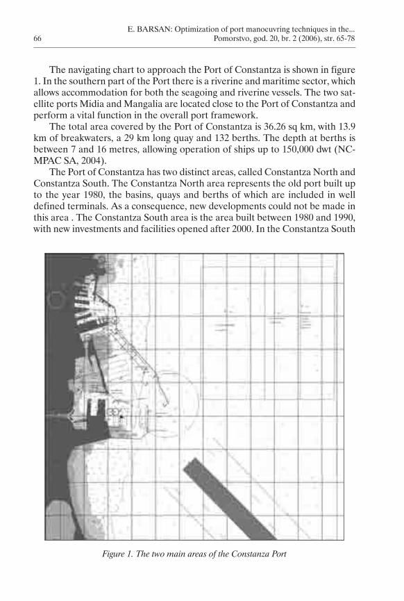
The navigating chart to approach the Port of Constantza is shown in figure 1. In the southern part of the Port there is a riverine and maritime sector, which allows accommodation for both the seagoing and riverine vessels. The two sat-ellite ports Midia and Mangalia are located close to the Port of Constantza and perform a vital function in the overall port framework.
The total area covered by the Port of Constantza is 36.26 sq km, with 13.9 km of breakwaters, a 29 km long quay and 132 berths. The depth at berths is between 7 and 16 metres, allowing operation of ships up to 150,000 dwt (NC-MPAC SA, 2004).
The Port of Constantza has two distinct areas, called Constantza North and Constantza South. The Constantza North area represents the old port built up to the year 1980, the basins, quays and berths of which are included in well defined terminals. As a consequence, new developments could not be made in this area . The Constantza South area is the area built between 1980 and 1990, with new investments and facilities opened after 2000. In the Constantza South
Figure 1. The two main areas of the Constanza Port
Pomorstvo_200�_2.indb �� 7.�2.200� ��:05:�2
E. BARSAN: Optimization of port manoeuvring techniques in the... Pomorstvo, god. 20, br. 2 (2006), str. 65-78 67
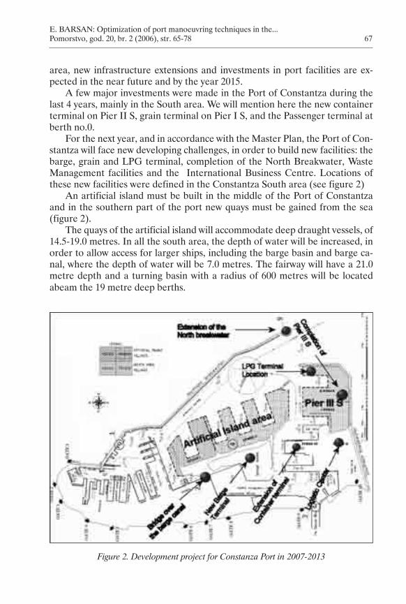
area, new infrastructure extensions and investments in port facilities are ex-pected in the near future and by the year 2015.
A few major investments were made in the Port of Constantza during the last 4 years, mainly in the South area. We will mention here the new container terminal on Pier II S, grain terminal on Pier I S, and the Passenger terminal at berth no.0.
For the next year, and in accordance with the Master Plan, the Port of Con-stantza will face new developing challenges, in order to build new facilities: the barge, grain and LPG terminal, completion of the North Breakwater, Waste Management facilities and the International Business Centre. Locations of these new facilities were defined in the Constantza South area (see figure 2)
An artificial island must be built in the middle of the Port of Constantza and in the southern part of the port new quays must be gained from the sea (figure 2).
The quays of the artificial island will accommodate deep draught vessels, of 14.5-19.0 metres. In all the south area, the depth of water will be increased, in order to allow access for larger ships, including the barge basin and barge ca-nal, where the depth of water will be 7.0 metres. The fairway will have a 21.0 metre depth and a turning basin with a radius of 600 metres will be located abeam the 19 metre deep berths.
Figure 2. Development project for Constanza Port in 2007-2013
Pomorstvo_200�_2.indb �7 7.�2.200� ��:05:��
E. BARSAN: Optimization of port manoeuvring techniques in the... 68 Pomorstvo, god. 20, br. 2 (2006), str. 65-78
2. WORKING HYPOTHESIS FOR SHIP HANDLING SCENARIOS
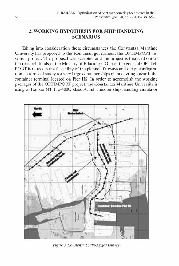
Taking into consideration these circumstances the Constantza Maritime University has proposed to the Romanian government the OPTIMPORT re-search project. The proposal was accepted and the project is financed out of the research funds of the Ministry of Education. One of the goals of OPTIM-PORT is to assess the feasibility of the planned fairways and quays configura-tion, in terms of safety for very large container ships manoeuvring towards the container terminal located on Pier IIS. In order to accomplish the working packages of the OPTIMPORT project, the Constantza Maritime University is using a Transas NT Pro-4000, class A, full mission ship handling simulator
Figure 3. Constanza South-Agigea fairway
Pomorstvo_200�_2.indb �8 7.�2.200� ��:05:��
E. BARSAN: Optimization of port manoeuvring techniques in the... Pomorstvo, god. 20, br. 2 (2006), str. 65-78 69
(FMSHS), and the maritime 3D and hydrological database specially created for the Constantza Port area.
In order to created scenarios with a high level of realism (Barsan E., 2006), we have started from the existing rules and procedures related to piloting and ship manoeuvres in the Port of Constantza.
In brief, the rules that imposed specific restrictions for the ship’s manoeu-vring (in the Constantza South-Agigea area) procedure are:
1. pilotage is compulsory for all seagoing ships, the pilot embarkation point is located 0.5 NM south of the north breakwater head (see map in figure 3);
2. only one tanker could use the entrance fairway at one time;3. ships entering the port must keep clear off the way ships are leaving the
port;4. the Constantza Port Control (VTS) could suspend manoeuvres if wind
exceeds 7 BFS or if visibility is lower than 0.5 NM;5. towing is compulsory for all ships exceeding 1000 NT, excepting ships
with bow thrusters and/or two propellers. Towing is compulsory in all the port area, excepting the entrance fairway (see map in figure 4);
6. the number and power of tugs is related to the ships length, reading as follows:
length lower than 130 metres – 1 tug of at least 600 HPlength between 131 and 150 metres – 2 tugs of at least 600 HPlength between 151 and 200 metres – 2 tugs of at least 2000 HPlength between 201 and 250 metres – 3 tugs (two of 2400 HP and one of 4800 HP)length greater than 250 metres – 4 tugs (two of 2400 HP and two of 4800 HP)
The power and number of tugs are very important elements that must be taken into consideration (TEWG, 2001) when we will simulate manoeuvres for full loaded bulk carriers (150000 DWT and above) and VLCCs (200000 DWT and above). According to item No.5 of the port safety regulations, containers and LPG carriers could be expected for tug request if they have bow/stern thrusters. As we know, the major part of container ships, with over 250 metres of LOA, have thrusters, so pursuant to the actual rules, they may try to ap-proach pier IIS, without tugs.
The first stage of the manoeuvring test on the FMSHS was done in order to assess if such large container ships are able to manoeuvre safely without the assistance of a tug on the narrow and sinuous fairway leading to pier IIS.
In accordance with the port expansion projects, we will also have to test if the designed turning basin with a 600 metre radius (figure 2) will be sufficient (USACE, 1987) for handling large ships in the deep draught berth area of Piers
•
•
•
•
•
Pomorstvo_200�_2.indb �9 7.�2.200� ��:05:��
E. BARSAN: Optimization of port manoeuvring techniques in the... 70 Pomorstvo, god. 20, br. 2 (2006), str. 65-78
II and III, including large ships that are performing turning circle using only own engine and thrusters.
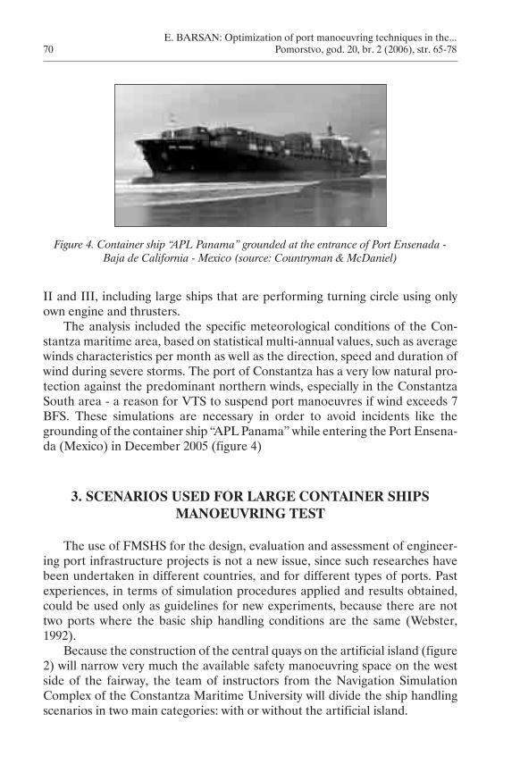
The analysis included the specific meteorological conditions of the Con-stantza maritime area, based on statistical multi-annual values, such as average winds characteristics per month as well as the direction, speed and duration of wind during severe storms. The port of Constantza has a very low natural pro-tection against the predominant northern winds, especially in the Constantza South area - a reason for VTS to suspend port manoeuvres if wind exceeds 7 BFS. These simulations are necessary in order to avoid incidents like the grounding of the container ship “APL Panama” while entering the Port Ensena-da (Mexico) in December 2005 (figure 4)
3. SCENARIOS USED FOR LARGE CONTAINER SHIPS MANOEUVRING TEST
The use of FMSHS for the design, evaluation and assessment of engineer-ing port infrastructure projects is not a new issue, since such researches have been undertaken in different countries, and for different types of ports. Past experiences, in terms of simulation procedures applied and results obtained, could be used only as guidelines for new experiments, because there are not two ports where the basic ship handling conditions are the same (Webster, 1992).
Because the construction of the central quays on the artificial island (figure 2) will narrow very much the available safety manoeuvring space on the west side of the fairway, the team of instructors from the Navigation Simulation Complex of the Constantza Maritime University will divide the ship handling scenarios in two main categories: with or without the artificial island.
Figure 4. Container ship “APL Panama” grounded at the entrance of Port Ensenada - Baja de California - Mexico (source: Countryman & McDaniel)
Pomorstvo_200�_2.indb 70 7.�2.200� ��:05:��
E. BARSAN: Optimization of port manoeuvring techniques in the... Pomorstvo, god. 20, br. 2 (2006), str. 65-78 71
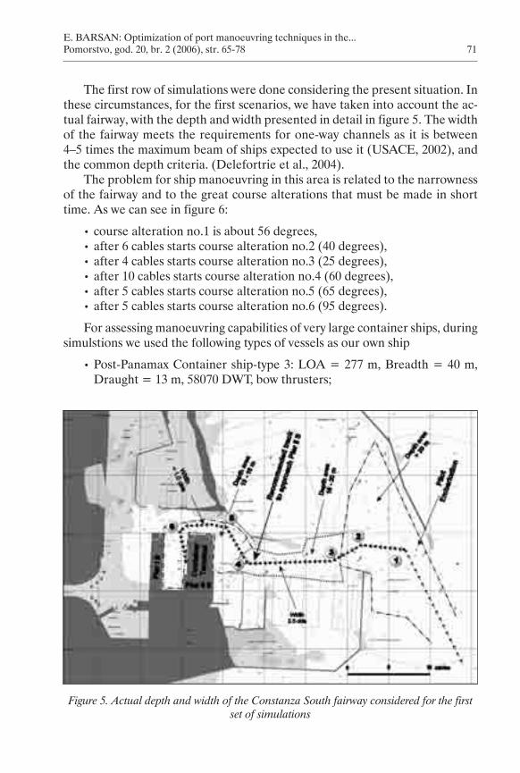
The first row of simulations were done considering the present situation. In these circumstances, for the first scenarios, we have taken into account the ac-tual fairway, with the depth and width presented in detail in figure 5. The width of the fairway meets the requirements for one-way channels as it is between 4–5 times the maximum beam of ships expected to use it (USACE, 2002), and the common depth criteria. (Delefortrie et al., 2004).
The problem for ship manoeuvring in this area is related to the narrowness of the fairway and to the great course alterations that must be made in short time. As we can see in figure 6:
For assessing manoeuvring capabilities of very large container ships, during simulstions we used the following types of vessels as our own ship
Post-Panamax Container ship-type 3: LOA = 277 m, Breadth = 40 m, Draught = 13 m, 58070 DWT, bow thrusters;
•
•
•
•
•
•
•
Figure 5. Actual depth and width of the Constanza South fairway considered for the first set of simulations
Pomorstvo_200�_2.indb 7� 7.�2.200� ��:05:�5
E. BARSAN: Optimization of port manoeuvring techniques in the... 72 Pomorstvo, god. 20, br. 2 (2006), str. 65-78
Post-Panamax Container ship–type 4: LOA=347 m, Breadth = 42.2 m, Draugh =14 m, 104696 DWT, bow and stern thrusters.
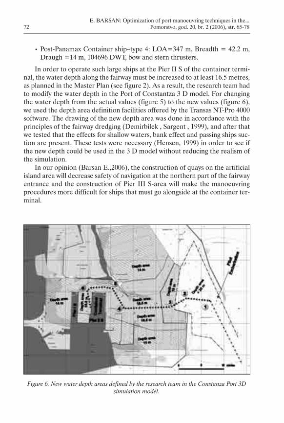
In order to operate such large ships at the Pier II S of the container termi-nal, the water depth along the fairway must be increased to at least 16.5 metres, as planned in the Master Plan (see figure 2). As a result, the research team had to modify the water depth in the Port of Constantza 3 D model. For changing the water depth from the actual values (figure 5) to the new values (figure 6), we used the depth area definition facilities offered by the Transas NT-Pro 4000 software. The drawing of the new depth area was done in accordance with the principles of the fairway dredging (Demirbilek , Sargent , 1999), and after that we tested that the effects for shallow waters, bank effect and passing ships suc-tion are present. These tests were necessary (Hensen, 1999) in order to see if the new depth could be used in the 3 D model without reducing the realism of the simulation.
In our opinion (Barsan E.,2006), the construction of quays on the artificial island area will decrease safety of navigation at the northern part of the fairway entrance and the construction of Pier III S-area will make the manoeuvring procedures more difficult for ships that must go alongside at the container ter-minal.
•
Figure 6. New water depth areas defined by the research team in the Constanza Port 3D simulation model.
Pomorstvo_200�_2.indb 72 7.�2.200� ��:05:��
E. BARSAN: Optimization of port manoeuvring techniques in the... Pomorstvo, god. 20, br. 2 (2006), str. 65-78 73
Starting with the 3D model updates, as shown in figure 7, we had to deter-mine for container ship type 3 and type 4, the following manoeuvring parame-tres and actions:
if the pilot could embark at the present pilot station point or he must board large container ships much more offshore;the maximum approaching speed to the pilot station (check point 1);;capabilities of large container ships to perform course alteration at check point 1, 2 and 3 without tugs;the maximum manoeuvring speed between check point 2 and 4;capabilities of large container ships to perform course alteration at check point 4 without tugs;capabilities of large container ships to perform course alteration at check point 5 and 6 without tugs;the risk involved if capabilities of large container ships will perform course alteration at check point 5 and 6 without tugs;where tugs must be in assistance;wind force and direction when large container ships will have to take 1 tug from check point 1;wind force and direction when large container ships will have to take 2 tugs from check point 1.
4. TEST RESULTS AND CONCLUSIONS
In this paper we will make only a brief description of the main findings after the first set of test undertaken in real time ship handling simulation.
The initial conditions for this first set of simulation were: no wind, so no drifting conditions, daylight, visibility good, no adjacent traffic, our own ship was a container ship type 3, simulation starts 3 miles before arriving to the ac-tual pilot station (checkpoint 1), duration of simulation 65-80 minutes. Simula-tions were performed in two stages:
stage I – 15 simulations performed only with a team of instructors from the Constantza Maritime University;stage II – 18 simulations performed by authorized pilots, working in the Port of Constantza. Each pilot performed two manoeuvres.
4.1 Stage I simulations
Before starting the manoeuvring simulations in the Constantza South area, instructors carried out a full scale of deep water trial of container ship type 3
•
•
•
•
•
•
•
•
•
•
•
•
Pomorstvo_200�_2.indb 7� 7.�2.200� ��:05:��
E. BARSAN: Optimization of port manoeuvring techniques in the... 74 Pomorstvo, god. 20, br. 2 (2006), str. 65-78
manoeuvring characteristics, consisting of: full turn to starboard and port, Zig-zag manoeuvre and reducing/increasing speed manoeuvres.
After that we proceeded to the port entrance and container terminal ap-proach tests. We started 3 miles off check point 1, with an initial manoeuvring speed of 10 knots. For these test we used our main bridge, that has a 240 degree horizontal field of view. The bridge team included 3-4 instructors.
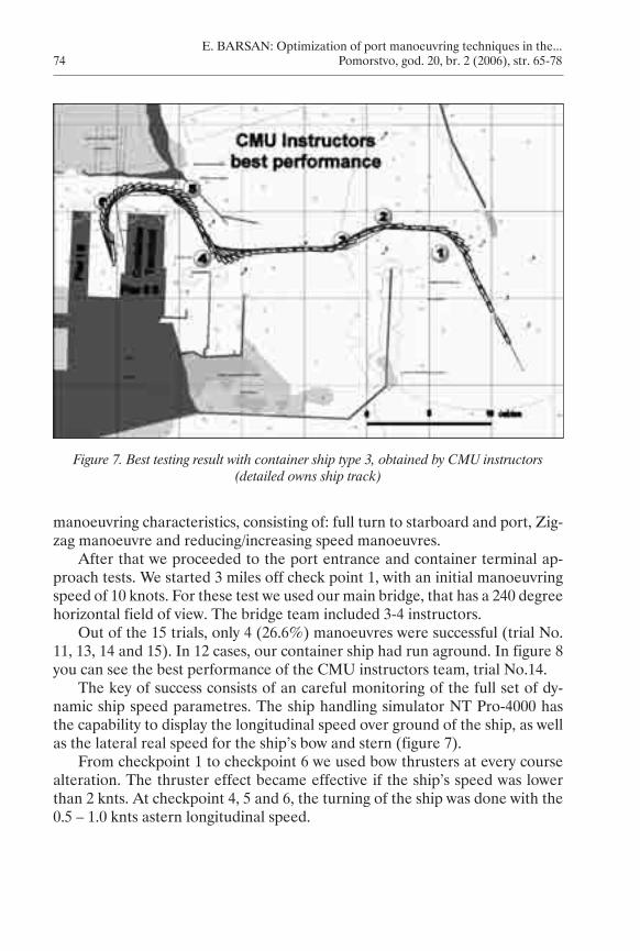
Out of the 15 trials, only 4 (26.6%) manoeuvres were successful (trial No. 11, 13, 14 and 15). In 12 cases, our container ship had run aground. In figure 8 you can see the best performance of the CMU instructors team, trial No.14.
The key of success consists of an careful monitoring of the full set of dy-namic ship speed parametres. The ship handling simulator NT Pro-4000 has the capability to display the longitudinal speed over ground of the ship, as well as the lateral real speed for the ship’s bow and stern (figure 7).
From checkpoint 1 to checkpoint 6 we used bow thrusters at every course alteration. The thruster effect became effective if the ship’s speed was lower than 2 knts. At checkpoint 4, 5 and 6, the turning of the ship was done with the 0.5 – 1.0 knts astern longitudinal speed.
Figure 7. Best testing result with container ship type 3, obtained by CMU instructors (detailed owns ship track)
Pomorstvo_200�_2.indb 7� 7.�2.200� ��:05:�7
E. BARSAN: Optimization of port manoeuvring techniques in the... Pomorstvo, god. 20, br. 2 (2006), str. 65-78 75
4.2 Stage II simulations
Stage II simulations were carried out with the assistance of authorized pi-lots working in the Port of Constantza. Pilots were voluntary engaged in this activity.
The bridge team consisted of 3 CMU instructors, acting as the regular ship’s bridge team (Master, OOW, helmsman), plus the authorized pilot. The ship’s bridge team carried out the pilot orders without comments or remarks. We helped the pilots to became familiar with the navigation equipment and we provided in due time all the information and data required by the pilot. Each pilot had to perform two entering manoeuvres. From the very beginning we have to underline that pilots were for the first time on board such a large con-tainer ship, they were for the first time working in the ship handling simulation environment and the depth of water along the approaching track was modified from the existing actual depth. The pilot was on board from the beginning of the exercise, meaning 3 NM off checkpoint 1. One day before the tests, we delivered to the pilots the full manoeuvering documentation of the ship.
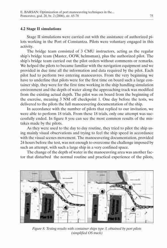
In accordance with the number of pilots that replied to our invitation, we were able to perform 18 trials. From these 18 trials, only one attempt was suc-cessfully ended. In figure 8 you can see the most common results of the mis-takes made by the pilots.
As they were used to the day to day routine, they tried to pilot the ship us-ing mainly visual observations and trying to feel the ship speed in accordance with the visual scenes movement. The manoeuvering documentation, provided 24 hours before the test, was not enough to overcome the challenge imposed by such an attempt, with such a large ship in a very confined space.
The change of the depth of water in the manoeuvring area was another fac-tor that disturbed the normal routine and practical experience of the pilots,
Figure 8. Testing results with container ships type 3, obtained by port pilots (simplified OS track)
Pomorstvo_200�_2.indb 75 7.�2.200� ��:05:�8
E. BARSAN: Optimization of port manoeuvring techniques in the... 76 Pomorstvo, god. 20, br. 2 (2006), str. 65-78
under keel clearance (UKC) being lower in case of container ship type 3, than the one for real ships operating today on Pier II S.
We assume that if every pilot will have a third attempt and if we had briefed about the reliability of the lateral speed data, the rate of success could have been increased to at least 75-80%.
One of the first conclusion of the OPTIMPORT project is that for such large container ships, it will be compulsory to take 1 tug who makes fast at the stern of the ship.
In accordance with our research schedule, we intend to pass to stage III trials, where we will have to increase the wind speed blowing from the north. We want to test the route between checkpoints 2 and 4, to see if the leeward produced by the abeam wind could generate dangerous navigation situation, before the ship reaches checkpoint 4.
We intend to keep the maritime community informed about our findings and to share the experience and results of our research. We will also make public the new manoeuvring procedures that we will find best to be used in order to increase safety of navigation in the Constantza Port area.
BIBLIOGRAPHY
1. Barsan, E., Redesign and Optimization of the Constantza Port Fairway, Genova, International Navigation Simulator Lecturers Conference, 2006.
2. Barsan, E., Bridge and Engine Room Teams Cooperation, in Loss of Remote Con-trol Scenarios, Genova, International Navigation Simulator Lecturers Conference, 2006.
3. Briggs, M. J., I. Melito, Z. Demirbilek, F. Sargent , Deep-Draft Entrance Channels:Deep-Draft Entrance Channels: Preliminary Comparisons Between Field and Laboratory Measurements, ERDC/ERDC/CHL CHETN-IX-7, U.S. Army Corps of Engineers, 2001.
4. Delefortrie, G., M. Vantorre, K. Eloot , E. Laforce, Revision of the Nautical Bottom Concept in the Harbour of Zeebrugge Through Ship Model Testing and Maneuver-ing Simulation, International Marine Simulator Forum – 31st Annual General Meeting, Antwerp, 2004.
5. Demirbilek, Z., F. Sargent , Deep-Draft Coastal Navigation Entrance Channel Practice, Coastal Engineering Technical Note, U.S. Army Corps of Engineers, 1999.
7. NCMPAC SA (National Company Maritime Ports Administration Constantza SA),NCMPAC SA (National Company Maritime Ports Administration Constantza SA), Constantza, Annual Report 2004, MPAC SA Press, 2004.
8. TEWG (Tug Escort Work Group),Methods and Assumptions Used in the Calcula-tion of Tug Selection Matrix, Hercules, California State Lands Commission Office, 2001.
9. USACE (U.S. Army Corps of Engineers), Environmental Engineering for Deep Draft Navigation Projects, EM 1110-2-1202, Washington DC, 1987.
Pomorstvo_200�_2.indb 7� 7.�2.200� ��:05:�8
E. BARSAN: Optimization of port manoeuvring techniques in the... Pomorstvo, god. 20, br. 2 (2006), str. 65-78 77
10. USACE (U.S. Army Corps of Engineers), Coastal Engineering Manual, EM 1110-2-1100, Washington DC, 2002.
11. Wang, S. L., P. Schonfeld, Scheduling Interdependent Waterway Projects Through Simulation and Genetic Optimization, Journal of Waterway, Port, Coastal and Ocean Eng., 131(2005), 3.
12. Webster, William C., Shiphandling Simulation: Application to Waterway Design, Washington DC, National Academies Press, 1992.
E. BARSAN: Optimization of port manoeuvring techniques in the... 78 Pomorstvo, god. 20, br. 2 (2006), str. 65-78
Sažetak
OPTIMIZACIJA TEHNIKE MANEVRIRANJA BRODOM U LUCI CONSTANTZA–JUŽNA AGIGEA
U posljednjih se 15 godina simulatori manevriranja brodom koriste pri projek-tiranju plovnih putova i terminala, kako bi se poboljšala sigurnost plovidbe i manevriranje brodom unutar luke. Prvi će se puta u području Crnog mora koristiti najnoviji model simulatora manevriranja brodom sa svim pratećim aktivnostima, kako bi se optimizirao projekt plovnog puta Constantza–Južna Agigea. Istraživanje će provesti Pomorsko sveučilište u Constantzi, uz dvogodišnju financijsku potporu od strane Nacionalnog sveučilišnog znanstvenoistraživačkog vijeća.
Skup nastavnika koji rade na Pomorskom fakultetu Pomorskog sveučilišta u Constantzi predali su program istraživanja, a koji je nastao slijedom postojećih razvojnih faza unutar glavnog plana razvoja luke. Razvoj luke Constantza finan-cira rumunjska Vlada, a vodi ga Lučka uprave luke Constantza.
U radu se daje prikaz dosadašnjih istraživanja, simulacija i pregled rezultata ostvarenih u drugom stadiju ovoga projekta, a koji uključuje simulaciju manevri-ranja velikim kontejnerskim brodovima sve do privezišta bez pomoći tegljača.
Ključne riječi: brod, simulacija, manevriranje, plovni put, luka
Constantza Maritime University Mircea cel Batrin street 1004, Constantza 900663 Romania