Optimum scenarios for Hen Harrier conservation in Ireland HENHARRIER FINAL REPORT April 2012 Prepared for the Department of Agriculture, Food & the Marine By Sandra Irwin, Mark Wilson, Barry O’Donoghue, Barry O’Mahony, Tom Kelly & John O’Halloran School of Biological, Earth & Environmental Sciences, University College Cork.
Transcript
Optimum scenarios for Hen Harrier conservation in Ireland
HENHARRIER
FINAL REPORT
April 2012
Prepared for the Department of Agriculture, Food & the Marine
By Sandra Irwin, Mark Wilson, Barry O’Donoghue, Barry O’Mahony,
Tom Kelly & John O’Halloran
School of Biological, Earth & Environmental Sciences, University College Cork.
i
Table of Contents ACKNOWLEDGEMENTS ....................................................................................................................................... ii PROJECT TEAM ................................................................................................................................................... ii EXECUTIVE SUMMARY ....................................................................................................................................... iii INTRODUCTION .................................................................................................................................................. 1
Breeding Biology ................................................................................................................................................ 31 Breeding Success in Different Habitats .............................................................................................................. 32 Diet ..................................................................................................................................................................... 32 Wing-tagging ...................................................................................................................................................... 32 Parental Behaviour ............................................................................................................................................. 32 Effects of Fieldwork on Breeding Success .......................................................................................................... 33
DISCUSSION ................................................................................................................................................................ 35 IMPLICATIONS FOR POLICY AND PRACTICE ....................................................................................................... 37 CONCLUSIONS AND RECOMMENDATIONS ........................................................................................................ 39 REFERENCES ..................................................................................................................................................... 41 FULL LIST OF OUTPUTS FROM THE PROJECT ...................................................................................................... 45 APPENDICES ..................................................................................................................................................... 47
Acknowledgements
ii
Acknowledgements This research project would not have been possible without the hard work and dedication of the Research Assistants that conducted seasonal fieldwork on breeding Hen Harriers, especially Geoff Oliver, Paul Troake, Chris Cullen and Barry Ryan. Independent ornithologists also provided invaluable data, including Brian Porter, Chris Peppiatt, Tony Nagle, John Lyden, Allan Mee and everyone who contributed to the National Hen Harrier surveys in 2000, 2005 and 2010. Thanks also to Pat Smiddy for valuable assistance with Hen Harrier pellet analysis and prey identification and to Richard Mills for photography. We would like to extend our thanks to National Parks and Wildlife Service staff, including members of the research unit David Norriss, David Tierney, Alyn Walsh and John Wilson, District Conservation Officers Frank McMahon, Stefan Jones, Seamus Hassett and Gerry Higgins and Conservation Rangers Tim O’Donoghue, Eva Sweeney, Jacinta Murphy, Sinead
Biggane, Aine Lynch, David Lyons Elaine Keegan, Emma Glanville, and others. We are also grateful to Coillte staff, particularly Pat Neville, John Galvin & Mark O’Loughlin for assistance with this project. An Advisory Group was established as part of the PLANFORBIO research programme and met three times during this project to coordinate the scientific research. The research team would like to acknowledge the valuable contribution of Advisory Group members Sue Iremonger, Eugene Hendrick, John Cross, Noel Foley, Keith Kirby, Alistair Pfeifer, Tor-Bjorn Larsson and Allan Watt. We also thank Giacomo Dell’Omo and Marco Scialotti of TechnoSmArt, Italy and John Edwards of Holohil, Canada as well as Hen Harrier researchers Antonio Pinalla, Beatriz Arroyo and Fergus Crystal, for help with remote tracking aspects of this work. Statistical advice was provided by Jay R. Rotella, Staffan Roos and Jessi Brown. Report writing was greatly assisted by Research Assistants Nora Lewon, Jason Parker and Steve O’Connell.
Project Team Prof. John O’Halloran University College Cork Programme Director Dr. Sandra Irwin University College Cork Programme Manager Dr. Tom Kelly University College Cork InvestigatorDr. Mark Wilson University College Cork Post-doctoral researcher Dr. Barry O’Donoghue National Parks & Wildlife Service PhD studentMr. Barry O’Mahony University College Cork Research AssistantMr. Paul Troake University College Cork Research AssistantMr. Barry Ryan University College Cork Research AssistantMr. Geoff Oliver National Parks & Wildlife Service Research AssistantMr. Chris Cullen University College Cork Research AssistantDr. Fidelma Butler University College Cork College Lecturer
Executive Summary
iii
Executive Summary Though widely distributed across the island of Ireland, Hen Harriers (Circus cyaneus) are relatively rare with a current estimated breeding population of just 128-172 pairs in the Republic of Ireland, and 63 territorial pairs in Northern Ireland. Hen Harriers have declined in range and population over the past 200 years, and the breeding population is now concentrated in the south and west of Ireland, particularly in the counties of Cork, Limerick and Kerry. Despite some, more recent, population increases, this species remains vulnerable and is listed as a species of conservation concern on Annex 1 of the European Union Birds Directive. This Directive requires that Ireland takes measures to ensure the persistence of Hen Harriers through designation of Special Protection Areas (SPAs), within which appropriate steps must be taken to provide and maintain suitable habitat for Hen Harriers. There are six designated Hen Harrier SPAs in Ireland at present, all of which all include suitable Hen Harrier breeding habitat such as heaths and bogs, rough grassland and conifer plantations. These SPAs must be managed in order to ensure the provision of suitable habitat in the face of future developments and land use change. The aim of the present study was to increase our knowledge of Hen Harrier breeding biology and habitat requirements to inform conservation management of this species in Ireland. During five breeding seasons from 2007 to 2011 detailed data was collected on Hen Harrier ecology in four study areas in Ireland using a range of appropriate methodologies including direct observations, nest cameras, GPS tags, pellet analysis and wing-tagging of juveniles. In order to meet our obligations to Hen Harriers under the EU Birds Directive it is essential that we are able to monitor land use change over time and to predict the impact of proposed land use change on Hen Harriers. To this end we created a customised GIS habitat database for Hen Harrier SPAs in Ireland to facilitate analysis of the degree to which land use change may affect Hen Harrier breeding success. This database will require updating to take account of future changes in the landscape within SPAs, but provides a framework and reference point against which such updating, and future monitoring can take place. Habitat change is the biggest single factor implicated in biodiversity loss today and is of critical importance to Hen Harriers, which are traditionally birds of open heathers and moors and depend on open habitat for
foraging. The GIS habitat database that was created during this project was used to investigate Hen Harrier nesting habitat preferences and the influence of habitat composition at the landscape scale on nest-site selection. We also investigated whether changes in the numbers of breeding Hen Harriers between the 2000 and 2005 National Surveys in Ireland were in any way related to nesting habitat, and whether there was evidence of Hen Harrier nesting distribution being restricted by cover of unsuitable habitat for nesting and foraging. The main nesting habitats selected by Hen Harriers were pre-thicket stage forests, particularly of second rotation plantations of exotic conifers. Improved grassland was strongly avoided as a nesting habitat and landscapes with a high percentage cover of grassland were also avoided. There was no evidence that the area of post-closure plantations impacted negatively on Hen Harrier nest distribution. There was a positive association between changes in numbers of Hen Harrier nests between 2000 and 2005 and changes in the area of pre-thicket second rotation plantations over the same period. These findings suggest that the overall effect of plantation forests on breeding Hen Harriers in Ireland is positive, and that further agricultural intensification of grassland in areas where Hen Harriers breed is likely to have a negative impact. With an increasing proportion of afforestation taking place in grassland habitats, some of which are of low value to Hen Harriers, the influence of afforestation is likely to be increasingly a positive one. Studies of Hen Harrier habitat use are commonly based on data collected by direct observation. This is an inefficient method for studying Hen Harriers, due to the low rate at which observations are made on this rare and wide-ranging species. Remote tracking would allow detailed information on habitat use by Hen Harriers to be collected much more efficiently but, until recently, such work has been constrained by the relatively small size of this raptor (which restricts the weight of the device that it can carry), as well as the cost of available technologies. Recent advances in remote tracking have resulted in the development of systems that are better suited to studying Hen Harriers. Following a thorough review of available technologies and published literature that considered the tag size, battery lifetime, positional accuracy, data retrieval and cost of available technologies, GPS (Global Positioning System) tags were selected for collection of foraging data from breeding adult Hen Harriers. In collaboration with Italian company TechnoSmArt, tags combining GPS units with a custom-
Executive Summary
iv
designed attachment mechanism (allowing the tag to fall off after data had been collected) and VHF transmitters (to enable tag retrieval) were developed. Using these tags, accurate data on habitat use by foraging Hen Harriers were collected remotely for the first time, at a much higher resolution that every before possible with this bird species, from three breeding adults in the Ballyhouras. Analysis of the GPS data shows that these birds range over greater distances than was found by researchers using VHF telemetry to study ranging behaviour of Hen Harriers in Scotland. During four days of tracking, the maximum distance from the nest travelled by a GPS-tracked female was 7.5 km and by a male was 11.4 km. Both forest and non-forest habitats were used in proportion to their availability but, within these categories, Hen Harriers showed preferences for second rotation pre-thicket forest, particularly forests between 3 and 9 years of age, and for grasslands managed at low intensity. These preferences broadly confirm the findings of previous studies on Hen Harrier foraging, but provide much more detailed information on which to base management recommendations. The protection of Hen Harriers in Ireland through the designation of SPAs also relies on accurate information on their breeding biology and breeding in Ireland. Such information allows the development of effective conservation strategies including, but not exclusively to, those centred on habitat management. Between 2007 and 2011 a detailed study of the breeding biology of Hen Harriers in four study areas (Slieve Aughty Mountains, West Clare, Kerry and Ballyhoura Mountains) in Ireland was undertaken. The study sites in the Slieve Aughty Mountains and in Kerry are designated SPAs, while the other two study sites hold relatively dense concentrations of breeding Hen Harriers. The aim of this study was to provide an understanding of the breeding ecology of Hen Harriers in order to inform conservation and land use planning. Data were collected during the breeding season between April and August each year. Territories were located by vantage point watches, nest locations subsequently identified and nest visits undertaken to gather information on breeding biology. The number of pairs of breeding Hen Harriers detected in each of three study areas, and included in our analyses, declined over the five years of the study. Nest success and fledged brood sizes were similar across study sites and did not show consistent trends during this period, except in West Clare where success rate of nests decreased. Although the number of young fledged by
successful Hen Harrier nests in this study was low, and the breeding productivity over the course of the study was low, this theoretically sufficient to allow Hen Harrier populations in these areas to remain stable, provided that juvenile survival and recruitment to the breeding population are sufficiently high. Detailed studies of juvenile Hen Harrier survival to breeding age in Ireland are therefore required to explore this further. Hen Harriers in Ireland currently appear to have responded favourably to recent afforestation of their upland breeding areas and, over the past two centuries and more, have proven their ability to adapt successfully to anthropogenic habitat changes in the landscapes they inhabit. However, some changes to these landscapes, including upland afforestation, are a relatively recent phenomenon and this species has co-existed with forested areas for only a few decades, and it is possible that its use of such landscapes may not be optimal. We therefore examined the relationship between breeding success and breeding habitat in Ireland to provide conservation managers with up-to-date information on which to base decisions about management and land use change in areas with Hen Harriers. We tested whether nest success and brood size were related to habitat type, both at the nest site and in the surrounding landscape. Neither measure of breeding productivity was related to total forest cover or to percentage cover of closed canopy forest in the landscape. However, in a subset of areas, second rotation pre-thicket forest (young forests planted on land from which a first rotation has already been harvested) was associated with low levels of breeding success. This may be due to local factors related to predation, disturbance or prey availability. The fact that second rotation pre-thicket forest is a preferred habitat for nesting in Ireland suggests that Hen Harriers may be making suboptimal selections from the habitats available to them in the landscape. However, further long-term investigation is required to improve our understanding of this relationship, enabling more effective conservation of Hen Harriers in forested landscapes. Hen Harriers are breeding successfully in Ireland at present and populations appear to be functioning sufficiently well at our study sites to allow them to persist in the forested landscapes that have replaced much of their traditional breeding habitat. Into the future careful targeted management is required to ensure their long-term survival and reproduction. This
Executive Summary
v
project provides detailed scientific data on Hen Harriers that is essential if Ireland is to meet its obligations to protect Hen Harriers and their habitats under the EU Birds Directive, which can only be achieved with the support of good policies and management practices. A number of recommendations are made, addressing different aspects of policy and practice and priorities for future research. There is scope to build on this significant body of work in the future to provide a more thorough understanding of Hen Harrier population ecology in Ireland, particularly in light of continued land use and climate change. The challenges that we face in this regard include investigations of the role of habitat quality in breeding success, the interaction between breeding and roosting populations, the fate of fledged young in Ireland and the source of our breeding population and factors of importance to Hen Harrier populations in the changing landscapes of the future.
Young Hen Harrier
Optimum Scenarios for Hen Harrier Conservation in Ireland: Final Project Report
Page 1
Introduction
Background Hen Harriers (Circus cyaneus) are medium sized, ground-nesting birds of prey that breed throughout Europe, North America and some parts of Asia, and extend their range further south in the winter to parts of North Africa, Asia and South America. Hen Harriers were once widespread throughout Ireland, but by the early 20th century their numbers had been substantially reduced by a combination of habitat loss and persecution (O'Flynn, 1983). The population increased again to an estimated 250-350 breeding pairs by the 1970s (Watson, 1977), but Hen Harriers are now a species of conservation concern in Ireland, having undergone another decline in breeding range over the past 25 years (Lynas et al., 2007). Though widely distributed in Ireland, these birds are relatively rare with a current estimated breeding population of just 128-172 pairs in the Republic of Ireland (Ruddock et al., 2012), and 63 territorial pairs in Northern Ireland (Sim et al., 2007). The breeding population is concentrated in the south and west of Ireland, particularly in counties Cork, Limerick and Kerry, which support approximately one third of the breeding Irish Hen Harrier population (Norriss et al., 2002; Barton et al., 2006).
Figure 1. Hen Harrier chick in its nest
on the forest f loor. Hen Harriers are vulnerable throughout their European range (Burfield and von Bommel, 2004) and are protected under Annex 1 of the European Birds Directive (209/147/EC). This Directive requires that Ireland takes measures to ensure the survival and
reproduction of Hen Harriers through designation of Special Protection Areas (SPAs) containing suitable habitat. Within SPAs appropriate steps must be taken to avoid habitat loss or deterioration, and to limit activities that could negatively impact on this species. EU member states are also obliged to ensure the effective protection of populations outside of these protection areas. Hen Harriers are ground nesting birds (Figure 1) that breed between April and July in upland areas and over-winter over a broader range that includes low-lying agricultural areas. They are traditionally regarded as birds of open moorland (Gibbons et al., 1993), but use recently established conifer plantations for hunting and nesting during the breeding season (Madders, 2003b). However, Hen Harriers cease to use plantations after canopy closure, and though Hen Harriers do utilise young second rotation forests (Norriss et al., 2002; Barton et al., 2006), this behaviour has not been reported from other parts of their range (Petty and Anderson, 1986), and these forests may be of less value to Hen Harriers than in their first rotation (O'Donoghue, 2004). A recent study suggested that Hen Harriers avoid landscapes where there is less than 30% bog, heath, rough pasture and young forest (Wilson et al., 2006). There are six designated Hen Harrier Special Protection Areas in Ireland, including parts of Clare, Cork, Galway, Kerry, Laois, Limerick, Monaghan, Offaly and Tipperary (Figure 2), all holding breeding pairs of Hen Harriers. These areas are comprised principally of heaths and bogs, rough grassland and conifer plantations, which are all important breeding habitats for this bird (Redpath et al., 1998; Norriss et al., 2002). These SPAs must be managed so that they remain suitable for Hen Harriers, whilst also meeting the economic and societal requirements of all relevant stakeholders. Although these areas were selected because they contained suitable habitat, even in the absence of further changes in land use, forest maturation in these SPAs over the next decade will result in a substantial decrease in the proportion of suitable habitat in many of these areas (Wilson et al., 2006). We therefore need to know more about the habitat requirements of Hen Harriers in Ireland to ensure that this species can be adequately provided for within the SPAs.
Optimum Sce
Page 2
Figure 2. TAreas for HB: SPA 0041
S Information performancefactors thatidentifying measures foin light of thforestry andand WhitfieHiggins et abehaviour anenable detabetter undedetermines tHen Harrierscover estimaapproximatioand makes nmay differ fspecies. Modecisions abthe SPAs areHen Harriersbe able to acurrent land maturation suitability ofuture.
enarios for He
The six desigHen Harriers i
161, C: SPA 0SPA 004167, F
on both breee, together wt limit distreffective pl
r bird specieshe expected sd wind energeld, 2006; Bral., 2009). Dnd breeding s
ailed comparirstand the wthe value of las. The 30% thated by Wilson of Hen Hano distinction from one anore detailed dout whether
e likely to affes in the long tessess land uscover, and alof existing p
eding biologyith an undersribution, areanning and . This is particensitivity of Hgy developmeright et al., etailed studiesuccess of Heisons betwee
within-habitat and to breedinhreshold of son et al. (20arrier habitat between hab
other in theirdata are neeor not land ct their carryierm. Land mae changes in so to be able plantations ws for Hen H
nservation in I
al Protection : SPA 004160PA 004165, E68).
y and breedinstanding of the essential
conservatiocularly relevanHen Harriers tents (Madde2008; Pearcees of foraginen Harriers wen habitats t
variation thang and foraginuitable habita
006) is only arequirement
bitat types thar value to thded to inforuse changes ing capacity fonagers need tthe context oto predict ho
will impact oarriers in th
Ireland: Final P
0, E:
ng he in
on nt to rs e-ng
will to at ng at an ts, at
his m in or to of
ow on he
The vand speccauspotethis condMan(Simlittlepopuand Harral., 1999(Mee20052008 Evidemanland and inten(LagRedpIsle moo(EtheHarrfoodpopupoteland AmahabiHarrhabi(Madrelat(Amaare vchan(ReddevereceSimiHarreffecspecDirec
Project Repor
vulnerability othe UK has
cies resulting ses and mechential conserv
species. Natiducted at inten and Ireland
et al., 2007; e work had beulations, but the Isle of Ma
rier breeding 1997; Meek9; Amar et aek et al., 1995; Amar and8).
ence-based iagement, hause change Redpath,
nsification (Paopus lagopuspath et al., 2of Man. Per
orlands is seridge et al., 1rier populatiod availability ulations has ential mechan
use change ar et al., 2005tat managem
rier populationtat requiremedders, 2000;tionship betwar et al., 2007vulnerable to
nge and, in tdpath et al., elopments iniving increasilar research o
riers in Irelandctive conservcies as requirctive.
t
of Hen Harrier prompted min a body ofanisms for thvation managional Hen Haervals of five yto monitor HRuddock et aleen carried ou
work in Scoan has providbiology (Picoet al., 1998;
al., 2007b) an98; Amar et a Redpath, 2
nformation, s been collecon Hen Harr2005), in p
ain et al., 1997) moors (Gree002a) in partsecution asso
significant in1997), but doens to the sam
in the sucreceived m
nism for the d(Picozzi, 198
). Recognitionment in the ns has led to aents, which d Arroyo et
ween habitat 7b; Amar et alo human intehis context, 2002b; Whitf
n the wind ing attention
on conservatiod is essential
vation managred by the E
r populationsmany studief work on theheir decline, agement strat
arrier surveysyears in the U
Hen Harrier pol., 2012). Untiut on Irish He
otland, Englanded informatioozzi, 1984; Eth
Green and End populatioal., 2003; Am
2005; Whitfie
vital for concted on the rier populatioparticular ag7) and managen and Etheridts of Scotlandociated with n parts of es not impactme extent. Thccess of Hemuch attentidecline associ80; Amar et n of the impo
conservationa body of wordiffer betwee
al., 2009) and breedin
l., 2007a). Heerference and
the effects ofield et al., 2
energy indn (Bright et aon manageme to allow us
gement plansEuropean Un
in Ireland s on this e possible as well as tegies for s are now UK, Isle of opulations l recently, en Harrier nd, Wales on on Hen heridge et Etheridge, n ecology
mar et al., eld et al.,
nservation effects of
ons (Amar gricultural
ged grouse dge, 1999; d and the managed Scotland
t Irish Hen he role of n Harrier on as a iated with al., 2003;
ortance of n of Hen rk on their en regions
and the g success n Harriers land use
of climate 2008) and ustry are al., 2008). ent of Hen to deliver
s for this nion Birds
Optimum Scenarios for Hen Harrier Conservation in Ireland: Final Project Report
Page 3
The objectives of this project, as outlined in the project proposal, were to: • Increase our knowledge of Hen Harrier ecology
and foraging behaviour. • Determine the value to Hen Harriers of the main
habitats in the SPAs. • Improve our understanding of Hen Harrier habitat
requirements at the landscape level, and revise recommendations accordingly, incorporating these into an Indicative Strategy for Hen Harrier management in the SPAs.
• Compile a GIS database of land use and habitat types within the SPAs, to function both as a tool for decision-making by SPA managers and stakeholders, and as a source of data for researchers.
Project Structure This project was funded by COFORD for a period of 5 years from 2007 to 2012 as part of the PLANFORBIO Research Programme. Additional financial support was provided each year by National Parks & Wildlife Service (NPWS) to increase manpower available for data collection during the breeding season. In addition Barry O’Donoghue, NPWS staff member, completed his PhD as part of this project, and was granted time during the breeding seasons of 2007 and 2008 to conduct fieldwork. Data and expertise were provided to this project by the Irish Raptor Study Group (IRSG). The research was divided into a number of Work Packages, each of which addressed a specific aim of the project as shown in Figure 3.
Figure 3. HENHARRIER project design.
Optimum Scenarios for Hen Harrier Conservation in Ireland: Final Project Report
Page 4
Work Package 1
Create Hen Harrier and habitat databases for SPAs
Background The EU Birds Directive (2009/147/EC), which provides protection for all wild bird species naturally occurring in the European Union, recognises that habitat loss and degradation are the most serious threats to the conservation of wild birds. It therefore protects habitats for endangered species listed in Annex 1, including Hen Harriers, in order to ensure their survival and reproduction (Donald et al., 2007). The primary instrument used by this directive for bird conservation involves the establishment of Special Protection Areas (SPAs) which require forests, and other habitats and land uses, to be managed in a way that ensures their suitability for protected species. In compliance with these regulations Ireland has designated six sites that provide suitable Hen Harrier breeding habitat as SPAs in Ireland (Wilson et al., 2010). These include habitats such as heaths and bogs, rough grassland and conifer plantations (Norriss et al., 2002; Barton et al., 2006). In order to monitor the suitability of habitats for Hen Harriers it is necessary to monitor land use change over time, and to be able to predict the impact of proposed land use change on Hen Harriers. The aim of this Work Package was to create a customised GIS habitat database for Hen Harrier SPAs to facilitate analyses of the degree to which agricultural improvement, grazing levels and cover of many different vegetation categories, including forests, affect parameters associated with Hen Harrier breeding success. The information in this database is of critical importance to the analyses undertaken in Work Packages 2, 4 and 5 of this project. Forestry proposals in Hen Harrier SPAs are currently evaluated on a first-come, first-served basis, with no proposals being accepted on peatland habitats, and an annual quota set on total area within the boundaries of each SPA. As well as providing
baseline habitat data for Hen Harrier SPAs, this database may also be used by managers and legislators to inform forestry policy and strategic planning in the SPAs.
Methodology The Geodatabase appended to this work package contains all the main datasets that contributed to the habitat-based analyses in this project. These were: 1. FIPS (Forest Inventory and Planning System): this
dataset contains detailed information on planting date and tree species composition for forests planted with recent grant-aid (from 1988 onwards), and broader information about forest age and type for forests established before this time.
2. Coillte inventory: this comprises detailed information about planting year and tree species composition for each sub-compartment (i.e. stand) in Coillte-owned plantation forests.
3. NPWS SPA habitat data: this dataset was compiled in 2006 for the purposes of delineating the boundaries of Hen Harrier SPAs according to presence of suitable habitats for Hen Harriers (Rough Grassland, Forest, and Heath/Bog).
4. Landcover data: these data were compiled by Teagasc for the Forest Service in 1997, and based principally on broad vegetation and landcover types identified from aerial photos and satellite imagery. It is probably the best classification of non-forest habitats available for the entire country, being higher resolution than the CORINE datasets, and utilising a land use classification much better suited to Ireland.
Each habitat analysis requires a different combination of information from the above datasets, depending on the areas and period of time under consideration, and the categories of habitat for which data is to be extracted. Figure 4 summarises the process by which information derived from these spatial datasets were combined and examined during GIS analyses of habitat. Firstly, the parent datasets were updated with the most recent data available. Afforestation data in FIPS can be updated on a near-annual basis using planting grant information, while felling data updates to the Coillte inventory can be derived from felling management plans, as well as from updates to the Coillte inventory itself. Information in the attribute tables of these datasets were queried and applied to
identify interest. all newlytaken frforests (forests arotation) Informatiboundariconsidera
The inforsure it istransitionyounger habitat dup to datis time photograagainst ttruthing classifiedof aeriacomplete2004/200to 2010) through t
the polygoAll informatio
y planted forerom FIPS. In(including thend young 'res
was taken ion on nones of SPAs ation as prop
Figure 4.
rmation in ths up to daten between blo
‘pre-thicket’ data in the fiete information
and laboaphs were athese, with ato check tha from photosl photograph
e coverage of 05, but more are available
the Google M
PA
H
A
ns represenon for privateests in their fnformation fe majority ostock' in its s
from the n-forest hab
(and areas osed SPAs) w
Flow diagram
his layer was e – particularocks of closed
growth stageld can providn on the habitur intensiveavailable, cheadditional fieat habitats a. Currently, th
hs for whichthe whole corecent photo
e for some paaps website.
ARENT DATAS• FIPS • Coillte • NPWS • Landcove
••••
HABITAT LAYE
ANALYSIS LAYE
EXDIF
Optimum Sce
ting habitate forests (inclufirst rotation)rom state-owof recently fecond commeCoillte dataitats within previously u
was taken from
m showing th
checked to rly with rega
canopy foresges. Collectioe high qualityats of interest
e. Where aecks were meld-based grore being corrhe most recenh there is untry was flowgraphs (from
was not availauthors of thusers of thisegarding the
• A•
YPES (FIPS) (Coillte) IPS & Coillte)(NPWS & Lan
MATION FROD UNION)
UTH
servation in Ir
abitat datasets were basedvant polygonsd, they wereons represenith one anoth
oung forests >abitats. The erged (using tshapefile or la
preparation
essed habitatporated in
which acc12) using ArcGeodatabase ts, and 2 Ge
ssible, metadavocated undeas added to sprated into theadata compildatasets, as
able. Howeveese data hav database tcompilation a
Afforestation Coillte felling
ndcover)
AERIAL PH
M
reland: Final P
t. Non-forest d on the landcs in each of th
e used to clipnting differenther) in the fo> closed canoclipped sets
the GIS functayer.
n for analysis
ts and landconto the companies cInfo 10.0. I Feature Clas
eodatabase taata complianter the EU INSPpatial datasete Geodatabasation was no the requireder, contact dve been provthat require and interpreta
Grants plans
HOTOS
Project Report
Page 5
habitat datacover dataset.hese datasets
one anothert habitats didllowing orderopy forests >
of polygonsion Union) to
s.
over datasetsHENHARRIERthis reportt contains 8
ss datasets, 8able datasets.t to ISO19115PIRE Directivets before theyse. Note thatt possible for
d informationetails for theided, so thatmore detail
ation of these
t
5
a . s r d r > s o
s R t 8 8 .
5 e y t r n e t l
e
Optimum Sce
Page 6
data can coneach datasetthe metadatabasis for established datasets coll Information tagged and tproject (200Geodatabasemetadata. Rthe codes angender, and weight, wingincluded theand/or chicksuccessful orto have fledgthree adult bduring 2010 aid interpretof the data can ArcMap 1the Geodatawere createdpurposes oninterpretive NASA’s SRTboundaries data. The mealso fully ISO The ArcMaspecifically ddatasets helvisualisation component allows for fuoverall PLANcapacity to brequired. Moheld in the Gbe found inprovided on this report. Ais available oDocument foalso as a ledocument fo
enarios for He
ntact them dirt has a compa. This allows on-going hawith future ected at a late
on all Hen Hthe Hen Harr07-2011) wae, accompaniRinging and wnd colours or several biom
g length and t position of thks found in r not, and the ged from the
breeding Hen and 2011 wa
tation, considcollected durin10.0 visualizatabase. Note td and added
nly. These suinformation
TM mission, derived from
etadata accomO19115-compl
p visualisatidesigned to en
d in the Geoand further
within the Hurther integraNFORBIO datbe updated wiore extensive
Geodatabase, n the HENH the HENHAR
Also note thaton the accomor licensed usess functionalor un-licensed
en Harrier Con
rectly. Also of letion date asfor the datas
abitat monitupdates ander date.
Harriers ringedier nests loca
as also enteied by ISO19wing-tagging wing-tags, thetric measurearsus width. Dhe nest, the nthe nest, wnumber of ch
e nest. FinallyHarriers fitteds added to th
deration, and ng the HENHAtion documenthat four basspecifically fo
upporting dat on relief
and land m Central Stmpanying theliant.
ion documencourage the odatabase. It analysis of th
HENHARRIER pation of theseabase, with ith future reseinformation oand visualizedARRIER GIS
RRIER-GIS CD t the visualisampanying CD sers of ArcGISl, though use users of ArcG
nservation in I
interest is thassigned to it ets to form thtoring to b new habita
d and/or wingated during thered into th9115-compliandetails include ring numbe
ements such aDetails of nesnumber of egg
whether it wahicks estimate, GPS tracks od with GPS tag
he database. Tinterpretatio
ARRIER projecnt accompanieseline dataseor visualisatioa give visualderived froadministratio
tatistics Officse datasets ar
nt has beeuser to explorallows acces
he spatial datproject. It alse data into ththe addition
sults land use anbase accuratthe period clsets were as, this was artat relating tohe project wn at the outseween the inftat on the curate classifi re 5 shows
erent datasetsanalysis, and e data resulticomparison w
ure 5. Screeninformation
oritized as d2007 habita
mposite imagcorrected accalysis of aerifol lows: darkrquoise = 1s t ation pre-thicough grassla
mproved gras
a
b
t
d habitat dately reflected ose in time
ssembled. Foound 2006, so nests and sas quite straet of the studformation in
ground wercations, or to
how the infs was assembl
the typical ng from field-
with aerial pho
shots showin
n from the difescribed in tt categories,e, but with a
cording to groal photos. Ha
k green = closrotation pre-cket, purple =nd, l ight gre
ssland, orang
tasets includland use coto when the
or the majoriso assemblingstudy areas atightforward. dy, some discn these datare apparent,
o recent chang
formation froled and categlevel of corr-based grounotographs.
ng a. Layeredfferent datas
the text and s and b. The s
a 2-km radiusound-truthinabitats are csed canopy fo-thicket, brow= heath & bo
een = agricultge = other ha
ed in the mposition
e relevant ty of the g data on t the start However,
crepancies asets and , due to ges in land
om these gorized for rection to d-truthing
d habitat sets, showing same s section
ng and coded as orest, wn = 2n d
og, blue = turally
abitats.
Optimum Scenarios for Hen Harrier Conservation in Ireland: Final Project Report
Page 7
Analyses of habitat pertaining to nests and bird movements studied later in the project required more extensive correction of these datasets, either using updates from the providers of the datasets (readily available for the forest datasets, but not for the data relating to the non-forest habitats), or recently flown, high-resolution aerial photos viewable in Google Maps. For some limited areas around nests for which such sources of information were either not available or were deemed to be inaccurate, extensive ground-truthing in the field was carried out. Hen Harrier ringing/tagging and nest information can be displayed at two spatial scales, each appropriate to the intended audience. The full version of the database, whose circulation will be limited to people and organizations who have been approved access to nest locations, will show precise positions for these data. However, because data on breeding Hen Harriers are deemed to be sensitive, due to the species being protected and potentially vulnerable to disturbance, a restricted version of the database will be made available to the general public, in which the same information will be shown at the spatial scale of the study site. The information held in the database can be subjected to further analysis, interpretation, consideration, and exploration using the HENHARRIER GIS. Some examples of these possibilities are illustrated in the figures below.
Figure 6. Extracting information about a tagged
Hen Harrier using the HENHARRIER-GIS.
Figure 7. Visualis ing NPWS habitats and terrain
using the HENHARRIER-GIS.
Figure 8. Exploring Coil lte habitats parcels using
the HENHARRIER-GIS.
Figure 9. Clarifying the “Who, What, Where, Why and How?” about a GPS tracking dataset using its
ISO19115-compliant Metadata.
Discussion The datasets contained in the Geodatabase provide a reference point against which future changes in habitat and land use in Ireland can be monitored. Changes in land use, and in the nature and value to Hen Harriers of habitats, have been part and parcel of the upland landscapes in which Hen Harriers have lived for millennia. It is worth bearing in mind that the vast majority of landscapes and habitats occupied by Hen Harriers today are the products of extensive alteration and continuous management by humans. The persistence of Hen Harriers in upland areas is testament to the adaptability of this species to such change. However, the rate at which changes are now taking place in many upland areas, and the socio-economic pressures that drive them, make it vital to periodically take stock of habitats in Hen Harrier areas, and to try to relate habitat changes to changes in occupancy, abundance and measures of breeding success. The Geodatabase produced here provides a store of the most useful habitats datasets identified, accompanied by information of their sources, and who to contact when updates are required.
Optimum Scenarios for Hen Harrier Conservation in Ireland: Final Project Report
Page 8
Together, the datasets in this database provide effective coverage of all forest and non-forest habitats utilised by Hen Harriers in this study. However, they will need to be kept up-to-date for them to continue to be useful for analysis of Hen Harrier habitat requirements. This is particularly the case for datasets pertaining to commercially managed plantation forests, because the cyclical activities of felling, re-planting and tree growth that characterise this land use mean that inconsistencies between forest datasets and the land they represent accumulate rapidly after this information has been collected. Unlike afforestation, felling and replanting are not grant-aided, and though the former takes place under license from the Forest Service, neither of these activities is formally recorded by the Irish State. Currently, the vast majority of felling and replanting happens in Coillte forests and is recorded in the Coillte inventory. However, there is a substantial lag between occurrence of these activities and their logging in the database. Coillte have 10-year felling plans outlining the forests they intend to fell and replant, but these plans are subject to change in response to factors such as licensing, market demand for timber, and the situations of contractors who fell, transport and process the timber. At the time of writing this report, many forests felled after 2007 have still not been recorded as felled and replanted in the Coillte inventory. Moreover, an increasing proportion of felling in the future will comprise privately planted forests, for which felling is not formally recorded in any national dataset. Though non-forest habitats are generally more stable over time than forests, land use change does take place in open habitats. Large-scale changes in uplands relevant to Hen Harriers arise from afforestation, agricultural intensification and farmland abandonment. However, this classification is increasingly out of date, and requires re-evaluation and updating in many areas to take account of recent land use changes. Because virtually all new plantings are grant-aided, information on afforestation is effectively captured by the Forest Service in FIPS. This dataset is formally updated every 5-10 years, but informal updates based on approved planting grants can be obtained from the Forest Service on a near-annual basis. Although not as accurate as the formal updates these provide useful information on afforestation. Changes in agricultural management are not so effectively captured. The data on non-
forest habitats included in this database derives from one-off surveys that, at least so far, have not been repeated or updated. Over time, these data will therefore become increasingly divergent from the habitats they represent, requiring an increasing amount of ground-truthing before they are used in analyses.
More regular updating of the habitat datasets included in this database would have clear benefits for future analyses of Hen Harrier habitat requirements, as well as for many other ecological and biodiversity studies. Two actions that would be particularly helpful in this regard are an update to the landcover dataset, and a broadening of FIPS updates to include restocked forest as well as new plantings. The landcover data was compiled 15 years ago, providing information on non-forest habitats at a higher resolution than is available from any other source with national coverage. However, its value relative to coarser datasets such as CORINE continues to be diminished by the changes to habitats which have occurred since the land use dataset was created. These data were originally created by combining automated interpretation of imagery derived from remote-sensing data with field and lab based ground-truthing. If this process could be further automated, this dataset could be updated whenever new remote imaging became available, allowing the dataset to be kept more up to date than has previously been possible. Broadening FIPS updates to include second (and subsequent) rotation plantings would provide a useful source of information against which to check and verify information in Coillte felling plans. More importantly, it would ensure that forest habitat changes relating to harvesting and replanting of private forests are captured consistently on a national scale. Without taking account of such changes, forest inventory information available for ROI will become
Recommendation 1: Felling and replanting are not currently grant-aided in Ireland, and though the former takes place under license from the Forest Service, neither of these activities is formally recorded by the Irish State. All felling and replanting in Ireland should be formally recorded within 6 months in a national GIS database. This might be achieved by increasing the frequency of FIPS updates, and broadening their remit to include establishment of second rotation forests as well as new plantings.
Optimum Scenarios for Hen Harrier Conservation in Ireland: Final Project Report
Page 9
increasingly difficult to interpret, and less useful for monitoring Hen Harrier habitats.
Collating the information contained in this Geodatabase and spatially analysing it using GIS allowed for a more effective analysis of Hen Harrier habitat than would be possible using any single dataset in isolation. The only datasets in this database that included information on all habitats of interest were the NPWS SPA habitat dataset and the Landcover dataset. Neither makes a distinction between first and second rotation forests, and neither has been updated since their creation. Currently, the only regularly-updated dataset that covers all the habitats of interest on a national scale is the EU habitat database, CORINE. The spatial resolution of this dataset is low compared to that of the datasets used in this analysis, and the relevance of some habitat classifications (particularly agricultural habitats) to Ireland is also low. Added to this, the fact that CORINE is only updated once every 5-10 years means that changes relating to forest felling and replanting, which are among the land use changes of greatest relevance to Hen Harriers, may be incorrectly represented. By combining the information from several datasets, as described above, we were able to assess Hen Harriers nesting habitat preferences in relation to habitat availability (Work Package 5), and also examine whether variation in breeding success could be related to habitat (Work Package 2). Both of these analyses were conducted at the level of the nest site and also
at the scale of the wider landscape. Based on the outcome of these analyses, we were also able to use these datasets to zone study areas according to their suitability for afforestation (Work Package 2).
Provision of the spatial datasets in a Geodatabase, accompanied by a visualisation tool, allows for further future exploration and use of the collated datasets. Such investigations could take the form of comparisons with new datasets, or updated habitat and landcover information, or exploring the links between habitat structure, species abundance, habitat quality, behaviour of individuals, and other variables of interest. This work would be complemented by investigations of the socioeconomic impacts of habitat management for Hen Harrier conservation. With relevant, complete metadata, the clarifications on who one needs to contact regarding the data, and the restrictions on data access and use which apply (particularly relevant to species listed on Annex 1 of the EU Birds Directive) are clearly and unambiguously stated. This can aid more rigorous compliance in terms of data-sharing and usage to the ideals envisioned in EU Directives such as 92/43/EEC (Habitats) and 2009/147/EC (Birds).
Recommendation 2: The quality and frequency of updating of data on non-forest habitats is in even greater need of improvement. Two actions that would be helpful in this regard would be to establish a system whereby landcover data can be updated regularly (preferably in an automated manner, using remote sensing datasets), and to explore the possibility of using CSO data on farm surveys as a proxy for land use data.
Recommendation 4: Hen Harrier conservation would benefit from a socioeconomic study of the benefits of complying with EU regulations to ensure that land uses are compatible with Hen Harrier conservation.
Recommendation 3: In addition to developing a land cover dataset for Ireland, we recommend a study aimed at calibrating CORINE data to facilitate its use in studies of birds in Ireland, possibly using data from the CBS (Countryside Bird Survey).
Optimum Scenarios for Hen Harrier Conservation in Ireland: Final Project Report
Page 10
Work Package 2
Model Hen Harrier habitat suitability
Background Habitat change is the single most important factor implicated in the declines of threatened and endangered bird species (BirdLife International, 2000). Many species are unable to persist in the face of habitat changes (Cerezo et al., 2010; Biamonte et al., 2011; Clavel et al., 2011), and even where species appear to cope with changes to the habitats they use, the habitat preferences of such species may become mismatched with the actual value of habitats available to them. This situation has been described as an ‘ecological trap’ by Gates and Gyssell (1978). One of the most profound and widespread habitat changes in recent times has been between forests and open habitats. Deforestation is of particular conservation concern in a global context (Buchanan et al., 2009; Loiselle et al., 2010; Sodhi et al., 2010), but the conversion of open, non-forested habitats of high conservation value to commercial forest has also attracted considerable attention (Brambilla et al., 2007; Brockerhoff et al., 2008; Lantschner et al., 2008). Over the past 60 years, many previously open upland areas in Ireland have been extensively afforested (Avery and Leslie, 1990; O'Leary et al., 2000), with total national forest cover rising from less than 2% to over 10% during this period. Many upland birds of conservation interest, including waders, raptors and passerines, respond negatively to afforestation, (Hancock and Avery, 1998; Buchanan et al., 2003; Whitfield et al., 2007), but others appear to be more compatible with newly established forested landscapes. One such species is the Hen Harrier, a species that previously bred almost exclusively in open habitats such as heather moors and extensive farmland (Watson, 1977; O'Flynn, 1983). However, now that the areas in which Irish Hen Harriers traditionally bred have been extensively afforested, they have adapted to nesting in young conifer plantations and are now frequently associated with these forests. A study of Hen Harrier nests found in Ireland during the national breeding surveys of 2000 and 2005 (Norriss
et al., 2002; Barton et al., 2006) found that the main habitats selected for nesting by Hen Harriers were the pre-thicket stages of first and, particularly, second rotation plantations dominated by exotic conifers (Wilson et al., 2009). This study also showed that landscapes with a high percentage cover of improved grassland were avoided by Hen Harriers when selecting nest sites. Restocked plantation forest has only become widely available to Hen Harriers in Ireland in recent decades, and so the preferences expressed in relation to this habitat, in terms of nest site selection, may not be entirely adaptive or translate into high breeding success. At present, afforestation is regulated in Hen Harrier SPAs by applying an annual limit to each area, such that afforestation is allowed to continue each year up to the point that the annual limit is reached. No preference is currently given to planting in different parts of the SPAs, according to existing levels of forest cover or other habitats. However, it would be in the interests of Hen Harriers to take such factors into account, to ensure that percentage cover of neither forest nor other habitats are allowed to reach levels that are unfavourable for this species. An alternative approach to regulating land use change at the level of the whole SPA would be to divide areas with Hen Harriers into different zones, according to availability of suitable open habitats and percentage cover of forests. Different rules could then be applied to land use changes in each zone. Similar approaches have been adopted in other countries, and have widely recognised advantages in situations where there are potential conflicts between development pressures, landscape concerns, public amenity and conservation objectives (Goodstadt, 1996; Mikusinski et al., 2007; Pant and Naig, 2007). This is a simple method of enabling assessment of proposed land use changes to be made in the context of surrounding land uses. It would ensure that habitat composition over large areas (but at a smaller scale, relevant to Hen Harriers) can be maintained within broad parameters that, according to the best information available, are favourable for this species. With this in mind the data from the present study were used to investigate the relationship between nesting habitat and breeding success, using data from 140 nests collected during the first 3 years of this project (2007 – 2009). The results of this analysis were used along with other data on Hen Harriers to generate strategic zones for Hen Harrier breeding
Optimum Scenarios for Hen Harrier Conservation in Ireland: Final Project Report
Page 11
areas, according to availability of habitats in the surrounding landscape.
Methodology
Breeding success and habitat Between 2007 and 2009 data on Hen Harrier breeding success and nesting habitat was conducted in the Ballyhoura Mountains, the Slieve Aughty Mountains, West Clare and Kerry. Together, these areas held approximately one third of the national breeding population (Barton et al., 2006). Nest locations were identified by close observation of breeding pairs, and the outcome of breeding attempts monitored using data gathered during nest visits and also by remote observation of nests. Successful nests were identified by the presence of recently-fledged juveniles in the nesting area. The number of chicks fledged was estimated, either according to the number of healthy chicks present during the final nest visit or, for nests that were not visited, as the maximum number of fledged juveniles seen flying in the nesting area post-fledging. Forested areas were assigned to three different categories – first rotation pre-thicket, second rotation pre-thicket, and other forest (mainly comprising closed canopy forest, but also including recently clearfelled areas). The two main sources were the Coillte forest inventory, and FIPS 2 (Forest Inventory and Planning System, the primary source of information for privately-owned forests). Forest habitat data was updated (Work Package 1) using information from the 10 year felling plan (2005 to 2015) and, in West Clare (where 61% of the forest area was privately owned), from examination of recent aerial photographs available on Google Maps to identify areas where recent felling had taken place. Open habitats were separated into just two categories, according to their suitability for foraging Hen Harriers: Suitable (comprising peatland heath and bog habitats, rough grassland and scrub) and Unsuitable (comprising improved grassland habitats and water). These categories were decided principally according to NPWS habitat maps of Hen Harrier proposed Special Areas of Protection (pSPAs), and the Irish Soils Land Cover dataset. Some ‘ground-truthing’ and comparison with aerial photographs was used to make corrections to these classifications, particularly in West Clare, which wasn’t included in the NPWS habitat survey for pSPAs.
We investigated two separate measures of breeding success: nest success (whether or not any chicks fledged from a nest) and fledged brood size (number of chicks fledged from a successful nest). Two of our study sites, Kerry and West Clare, were similar to one another in terms of the levels of productivity in all three study years (see Work Package 5) and also in terms of habitat composition (Table 1), and were combined into a single ‘Western’ category.
Table 1. Size and proportion of land in each of six habitat categories in the four study areas.
The effects of study area, year and habitat on nest success were analysed using GLM (General Linear Modelling) in MARK 6.1 (White and Burnham, 1999) using the programme's nest survival analysis procedure (Rotella et al., 2004). This takes account of the influence of nest stage at time of finding on apparent survival, calculating a daily survival rate for each nest. The explanatory variables considered for inclusion in the nest survival models were study area, year and 6 habitat variables at the landscape scale. These models were ranked according to AICc (Akaike Information Criterion corrected for small sample sizes), the top model being the one with the lowest AICc score. The strength of inference for each model depended on a) its ΔAICc score b) whether and to what extent the confidence intervals of the model parameters overlapped with zero, and c) the magnitude of the biological effects estimated by the model over the relevant conditions of interest in the study. A deviance-based r2 value (ANODEV) was calculated for each of the top models, following White and Burnham (1999). This is a measure of the
Optimum Scenarios for Hen Harrier Conservation in Ireland: Final Project Report
Page 12
variation accounted for by each model of interest, relative to the variation accounted for by a general model containing all terms of interest. First, the residual deviance (D) was calculated for three models: the null (intercept only) model (MN), the model being tested (MT) and a general model (MG) containing all main and first-order interaction terms in the model set. ANODEV was then calculated using the formula: r = 1 − D − DD − D
Afforestation suitability According to the findings of the analysis of breeding success and habitat, Hen Harrier breeding success decreases noticeably when the percentage of second rotation pre-thicket forest in the surrounding landscape is greater than 10% (Wilson et al., 2009). In a forest landscape with a well-balanced age-structure, approximately one quarter of the forest estate will be in pre-thicket stage at any one time. A maximum threshold of 40% for total forest cover in the landscape would therefore ensure that the percentage of pre-thicket forest did not regularly exceed 10%. Previous work also suggests that suitable habitat cover should not be allowed to decrease below 30% in order for landscapes to remain attractive to breeding Hen Harriers (Wilson et al., 2006). Given the negative relationship between second rotation pre-thicket forests and Hen Harrier breeding success (see below), this would be a prudent minimum threshold for percentage cover of suitable open habitats in areas being managed for Hen Harriers. We made a strategic assessment of suitability for afforestation of three of our four study areas (we did not include West Clare because the NPWS habitat map that part of this assessment was based on did not cover this area). Using the Focal Statistics tool in the Neighbourhood Toolbox in ArcGIS 10, we created two raster maps of our study sites with a resolution of 100m. In one map, the value of each cell was equal to percentage cover of forest habitats within a 2 km radius. In the other, cell values were determined as the percentage cover of suitable non-forest habitats (rough pasture and heath/bog) within a 2 km radius. These two classifications were used to derive two maps, each classifying areas within the study sites
into three categories: a) < 20%, 20-40% and > 40% forest cover and b) <30%, 30 – 50% and > 50% suitable open habitat. These two maps were then combined to derive four zones of suitability for afforestation: 1. Most suitable: suitable open habitat cover > 50%,
4. Least suitable: suitable open habitat cover<30%, forest cover >40%.
Results
Breeding success and habitat The outcomes of 178 nests from the four study areas were recorded between 2007 and 2011. Table 2 gives the AICc scores, weights, deviance and ANODEV (rd
2) values for the 6 nest survival models that were better (i.e. had a lower AICc score) than the null model, and for the null model itself. Parameter estimates and 95% confidence limits around these parameters are presented for the parameters of each of these models in Table 3. All six models that were better than the null model included study area, strongly indicating that this variable was related to nest success (Table 2). The top model, for which rd
2 was 0.24, also included second rotation pre-thicket forest within 2 km and the interaction between this variable and study area. Parameter estimates for this interaction term indicate that second rotation pre-thicket forest at a landscape scale was negatively related to nest success in the Slieve Aughty Mountains, but there is no evidence of a similar relationship in the Ballyhouras (Table 3). Although the parameter estimate for the interaction between second rotation pre-thicket forest and study area for West Clare suggests that the same negative relationship might apply here, the confidence intervals for this estimate overlap with zero.
Optimum Scenarios for Hen Harrier Conservation in Ireland: Final Project Report
Page 13
Table 2. Summary properties of MARK nest survival models with AICc scores lower than the null model (details of the latter are in the bottom row of the data). The explanatory variables included in each model are l isted in the Formula column as fol lows: Area (3 level factor coding for study area); Year (5 level factor coding for study year); habitat variables ending in “_2km” coding for the proportion of land within 2km of the nest occupied by 2nd rotation pre-thicket (2ndr), non-foraging habitat (comprising intensively managed grassland and standing water) (Unsuitable), and foraging habitat (comprising heath/bog habitats, rough grazing and water) (Suitable). Where two variables are separated by an asterisk, the interaction between these variables was included in the model. Variables separated from one another by a plus sign indicate that only the main effects were included in the model. The other columns represent K (the number of parameters in the model), AICc, AIC weight (Wt), the cumulative AIC weight (Cum.Wt), residual deviance, and the pseudo-r2 measure rd
Table 3. Parameter estimates, standard errors (se) and lower and upper confidence intervals (LCI and UCI, respectively) for the top model among nest survival models. See Table 3 for an explanation of codes in the Formula column. Level 1 of the three-level factor Area (as well as level 1 of the interaction between Area and 2ndr_2km) is incorporated within the intercept, as is standard practice in GLMs. Area level1 ( incorporated in the intercept) is the Sl ieve Aughty Mountains, Area level2 is the Ballyhouras, and Area level3 is the Western study area.
Table 4. Total area of each study site, the proportion occupied by forest, and (separately for the whole of each study site, and for the proportion of the study site not covered by forest habitats) the proportion fal l ing into f ive categories with respect to suitabil ity for afforestation: 1. suitable open habitat cover > 50% and forest cover < 20%; 2. suitable open habitat cover > 50% and forest cover 20-40%; or suitable open habitat cover 30-50% and forest cover < 20%; 3. suitable open habitat cover 30-50%, forest cover 20-40%; 4. suitable open habitat cover<30%, forest cover >40%. The last category, t it led “Most suitable for afforestation”, comprises the total of the f irst three categories.
Sl. Aughty Mts Ballyhouras Kerry TOTAL AREA (km2) 674 319 106 FORESTED AREA (%) 49 48 75 ENTIRE STUDY SITE Category 1 (%) 4 0 0 Category 2 (%) 19 17 0 Category 3 (%) 12 24 1 Category 4 (%) 64 58 99 Most suitable for afforestation (%) 36 42 1 ONLY NON-FOREST AREAS Category 1 (%) 8 1 0 Category 2 (%) 30 24 0 Category 3 (%) 17 29 4 Category 4 (%) 46 46 96 Most suitable for afforestation (%) 54 54 4
Optimum Scenarios for Hen Harrier Conservation in Ireland: Final Project Report
Page 14
The above conclusions are nearly identical to those of a more detailed analysis of a subset of the same breeding data (covering the period from 2007 to 2009), which included data on open as well as forested habitats. This analysis forms the basis of a paper on Hen Harrier habitat and breeding success that has been accepted for publication by the academic journal Ibis (Appendix 5), and a COFORD Connects note on the use of forested landscapes by Hen Harriers in Ireland (Appendix 3). Afforestation suitability The overall area of each study site is shown in Figure 10, and the proportion of each site within each of the four suitability categories. If afforestation of habitats suitable to Hen Harriers was limited to areas where surrounding forest cover was less than 40% and combined cover of peatlands and rough grazing was
greater than 30% (categories 1 – 3 in Figure 10), then 36% of the Slieve Aughty Mountains SPA, 42% of the Kerry part of the Stacks and Mullaghreirks SPA, and only 1% of the Ballyhouras would be potentially suitable for afforestation. For the Slieve Aughty Mountains, this is the area marked in green, yellow and orange in Figure 10c. Restricting consideration only to non-forested areas (as these are the only areas that are available to be afforested), this percentage increases to 54% for the Slieve Aughty Mountains and Kerry, and 4% for the Ballyhouras. This is illustrated in Figure 10d, in which only the areas not occupied by forest (represented in dark green) are considered in calculating the proportion of land suitable for afforestation. The reason for the very low value for the Ballyhouras is that forest cover in this area is higher than in any other area, and cover of open suitable habitats is very low.
Figure 10. Maps of the Sl ieve Aughty Mountains Hen Harrier SPA, stratif ied according to a) percentage cover of forests within 2 km of each 10 x 10 metre cel l (red: >40%; orange: 20% to 40%; yel low: <20%), b) availability of rough grazing and peatland habitats within 2 km of each 10 X 10 metre cel l (darker green: >50%; l ight green: 30-50%; yel low: <30%), c) priorit isation index for afforestation (red: highest level of
forest or lowest level of suitable open habitat; orange: intermediate level of both forest and open habitat; yel low: lowest level of forest or highest level of suitable open habitat ( intermediate level of the other); green: lowest level of forest and highest level of suitable open habitat), and d) same as map c but with
forested areas marked in dark green.
Optimum Scenarios for Hen Harrier Conservation in Ireland: Final Project Report
Page 15
Discussion
Breeding success and habitat The negative relationship between second rotation pre-thicket forests and Hen Harrier breeding success is notable, particularly because second rotation pre-thicket forest is a preferred habitat for nesting in Ireland (Wilson et al., 2009). This suggests that Hen Harriers may be making suboptimal decisions regarding habitat selection in the landscapes available to them. Such a relationship could arise from a direct effect of second rotation pre-thicket forests on Hen Harriers. This could be the case if this habitat were associated either with unusually high abundance or activity of predators, or with unusually low abundance or availability of prey. Hen Harrier breeding success can be affected by availability of food both before and during the nest period (Amar and Redpath, 2002; Amar et al., 2003; Amar et al., 2005). If availability of prey was lower in pre-thicket second rotation forest than in alternative hunting habitats, Hen Harriers breeding in landscapes with a high proportion of this habitat could be disadvantaged. One way in which such an effect could come about is through the presence of brash (woody debris left after forest operations) in young second rotation forests, which might make access by harriers to prey more restricted than in other habitats. The observed area-specificity of the relationship might then be explained if the prey types available in the Slieve Aughty Mountains were better able to take advantage of the cover provided by this habitat, or if there were differences in the way this habitat was managed in this area relative to our other study areas. Alternatively, second rotation pre-thicket forests could be associated with other landscape features or properties that have a negative impact on Hen Harrier breeding success. High levels of nest loss and predation have been associated with edge habitats (Weldon and Haddad, 2005; Hoover et al., 2006; Pedersen et al., 2009), and internal forest edges are likely to be more prominent in forests with high levels of second rotation pre-thicket forest. Also, the proportion of second rotation forest is highest in areas where plantation forests have been established for the greatest length of time. Such areas may support greater concentrations of nest predators such as foxes, corvids and mustelids, densities of which can be positively affected both by total area of forest and by the density of forest edge habitats
(Chadwick et al., 1997; Smedshaug et al., 2002; Carey et al., 2007). Pine Marten (Martes martes) is a forest mustelid that opportunistically preys on bird eggs and whose numbers have responded positively to the recent increase in Ireland's plantation forest cover. It is now most numerous in areas where suitable habitat such as conifer forest has existed for longest (National Parks and Wildlife Service, 2008). If nest success is affected by predators such as Pine Marten, this might help to explain the difference in the effect of second rotation pre-thicket forest between study areas, as the abundance of this species is probably higher in the Slieve Aughty Mountains than in our other study areas (O’Mahony et al. (2006); Declan O’Mahony pers. comm.).
Afforestation suitability The management of habitats for Hen Harriers should aim to minimise fluctuation in the availability of pre-thicket forests over time, by ensuring a consistent matrix of different aged forest stands at the landscape level. Particularly in areas with high levels of forest cover, where second rotation pre-thicket forest often constitutes a large proportion of the suitable habitat available, this would help to minimise the length and severity of any 'bottle-necking' effect of periods where the landscape is dominated by closed canopy forest. Also, if second rotation pre-thicket forest can have a direct and negative impact on Hen Harrier breeding success, then maintaining a mix of age classes within forest estates in Hen Harrier areas would help to avoid periods in which cover of this habitat was particularly high. In even-aged stands, a mix of different ages can be achieved over time by bringing forward or delaying harvesting dates of particular stands, or by leaving some felled stands for a 'fallow' period of several years before they are planted. The latter option has the added benefit of extending the length of time that forested areas spend out of closed canopy stages, thereby increasing their overall value to Hen Harriers. The degree to which such measures could be employed depends to a large extent on commercial factors, but the 'fallowing' method described above is already being employed in several upland areas as part of an integrated strategy to reduce the incidence and intensity of pine weevil infestations (Dillon and Griffin, 2008). Also, a steady and predictable supply of timber, such as should result from a forest estate being managed to include
Optimum Scenarios for Hen Harrier Conservation in Ireland: Final Project Report
Page 16
a mix of different aged stands, is likely to be of greater economic use to the local forest industry than one in which demand varies widely between years. It would certainly be desirable to achieve a mix of forest ages at the scale of an SPA. However, SPAs such as the Slieve Aughty Mountains are very large, with widely separated Hen Harrier territories that are unlikely to overlap in foraging range. It would therefore be prudent to ensure that a mix of different ages is also retained at a smaller scale. Finding the best scale at which to organise harvesting and replanting to achieve a balance of forest ages depends on balancing the potential benefits of a consistent mix of forest ages in all Hen Harrier territories with the increased difficulty of achieving this at small scales. Inevitably, availability of second rotation pre-thicket forest will fluctuate widely over time at the level of some Hen Harrier territories. However, this species is quite flexible in its breeding habits, with pairs capable of moving several kilometres between and even within seasons (Paul Troake and Barry O'Mahony, pers. comm.). Also, in less heavily afforested areas, breeding Hen Harriers are likely to be able to make greater use of alternative habitats when availability of second rotation forests is low. The negative relationship between second rotation pre-thicket forests and Hen Harrier breeding success observed in the Slieve Aughty Mountains suggests that as well as ensuring a continued mix of growth stages in the forest estate over time, it would also be desirable to regulate expansion of forests in areas with Hen Harriers. This is especially so in the Slieve Aughty Mountains where this relationship has been observed, but possibly also elsewhere to ensure that levels of second rotation pre-thicket forest do not regularly reach the levels associated with the negative impacts on breeding success we observed.
At present, afforestation is regulated in Hen Harrier SPAs by applying an annual limit to each area, without regard for variation in existing levels of forest cover or other habitats within each SPA. The strategic approach to zoning SPAs according to their suitability for afforestation, demonstrated above, is one way of ensuring that habitat composition within SPAs is regulated on a scale appropriate to Hen Harriers. It is easy to implement on a case-by-case basis, and also to update, at least in terms of afforested areas. Updates of rough grassland and peatland habitats could be made according from aerial photographs or from satellite data, but it would require considerable effort to manually extract the relevant data from such sources (see discussion in Work Package 1). Coupled with the fact that such remote datasets are not updated on an annual basis, it is likely that zones would not be updated according to information pertaining to non-forest habitats much more frequently than once every five years.
Recommendation 5: The long-term influence of forested areas on Hen Harriers is likely to be optimised by minimising fluctuations in the availability of forest growth stages (such as pre-thicket, thicket and closed canopy forest) over time, by ensuring a consistent matrix of different aged forest stands is maintained at the landscape level. This would help to avoid ‘bottleneck’ effects due to periods when the cover of any one habitat was particularly high or low. We recommend a strategic approach to zoning SPAs according to their suitability for afforestation, as a means of ensuring that habitat composition within SPAs is regulated on a scale appropriate for Hen Harriers.
Optimum Scenarios for Hen Harrier Conservation in Ireland: Final Project Report
Page 17
Work Package 3
Review remote tracking methodologies
Background The majority of studies of habitat use by foraging Hen Harriers to date have used data collected by direct observation (Madders, 2003a; Amar and Redpath, 2005; Wilson et al., 2009). This method is time consuming and subject to bias, as some areas are more easily watched than others, also direct observations do not generally allow observations of foraging birds to be associated with their nest. Remote tracking of Hen Harriers using satellite, GPS or radio tags would provide a far more efficient method of collecting detailed information on habitat use by Hen Harriers of the type required by Work Package 4 of this project (Hardey et al., 2006). Conservation research, in particular, has benefitted from recent developments in remote tracking (Croxall et al., 2005; Cooke, 2008; Catry et al., 2011). In the past it has not been possible to use these tracking methods on birds of the Hen Harrier’s size due to weight constraints, however recent advances in these technologies render them now potentially more applicable to this study. Issues of tag size (tags should weigh no more than 3% of a bird’s weight, which for Hen Harriers means about 10g), battery lifetime, positional accuracy, data retrieval and cost all had to be thoroughly investigated selecting which, if any, of these methodologies should be used in Work Package 4. A review of the available literature was therefore undertaken. However, because many relevant developments in this field were either too recent to have been published, or were ongoing, this literature review was complemented by an extensive search for non-published information, by directly contacting researchers, developers and end-users of remote-tracking technologies. The results of this Work Package were used to inform the methodologies employed in Work Package 4.
Methodology In order to gather information for the review, and gain practical experience in trapping Harriers which will be essential to work on foraging ecology in Work Package 4 members of the project team visited and worked with Beatriz Arroyo of the Consejo Superior de Investigaciones Científicas, Spain, who had worked on Hen Harriers for several years. Project team members were trained by Beatriz Arroyo, Raul Alonso (BRINZAL Centro de Recupración de Rapaces Nocturnas, Madrid) and also Antonio Pinilla and Fergus Crystal (AMUS Centro de Recuperación de Fauna Protegida y Centro en Cria en Cautividad del Aguilucho Cenizo, Villafranca de los Barros). The team gathered information essential to reviewing remote tracking technologies and gained valuable experience in field techniques relevant in the capture of harrier species for remote tracking essential for Work Package 4 and for wing-tagging subsequently conducted as part of Work Package 5 (Figure 11 and Figure 12). This information transfer was invaluable to the success of the current project. Techniques learned included:
• Harrier trapping using decoys and a net • Harrier trapping using pole traps • Harness attachment • Wing-tagging
Figure 11. Mark Wilson learning capture
techniques for Montague’s Harriers
An extensive review of literature, online information and existing relevant tracking technologies was also undertaken to inform Work Package 4. Over 400 papers using telemetry from recent years were reviewed and information collated on the type of telemetric technology used; species and size of study animals, weight of tag, method of tag attachment, lifetime of battery, accuracy of positional data, costs and requirements in terms of equipment and
Optimum Scenarios for Hen Harrier Conservation in Ireland: Final Project Report
Page 18
manpower, method of data retrieval, and any other relevant capabilities or limitations of the tracking system.
Figure 12. Training in attachment of VHF radio
transmitter.
Results Ecological studies employ a range of different types of tag in remote tracking of individual animals from simple VHF tags to complex Geolocators, with the specific tag dependant on the requirements of each study and the ability of the animal to carry the tag. Acoustic tags, specifically sonic and ultrasonic tags, are the preferred choice when studying aquatic organisms as these devices produce sound waves which propagate much more effectively than radio waves underwater. VHF (Very High Frequency Radio), which emits radio waves, is the most commonly used remote tracking technology for terrestrial animals (Sutherland et al., 2004). The tag emits a relatively weak signal allowing it to be tracked until the animal is found and observations can commence. Accuracy in locating animals by triangulating the signal using multiple receivers can depend on topography and proximity of tags and receivers. Satellite Platform Transmitter Terminals (PTT) are similar to VHF tags in that they both emit a radio signal. PTTs however emit a signal 100 or 200 times more powerful than VHF. This means the tag can be detected from anywhere on earth, however, if the satellites view of the tag is obstructed by topography, buildings, dense vegetation or by the Earth itself the signal will be blocked. Even in optimal conditions the accuracy of these devices is never less than 100m. These devices are also capable of transmitting data giving them a high power requirement and so size constraints are more severe (Keating et al., 1991).
Passive Integrated Transponder (PIT) tags are microchip devices that can be scanned to reveal the identity of an individual animal and are most appropriate for studies of animal movement past a fixed point scanner (Dell'Omo et al., 2000). These tags are not actively powered as they are powered by an interrogatory pulse of energy (acoustic or electrical) from an external receiver unit, however, they can only be detected within a range of a few centimetres limiting their usefulness to monitoring birds and fish in narrow rivers, or in the aquaculture industry. Because they do not require a battery they are the smallest remote tracking devices available. Of all the technologies reviewed Global Positioning System (GPS) devices were the only ones with sufficient accuracy to provide the type of detailed information required when investigating Hen Harrier foraging habitat. GPS tags work by receiving signals from an array of satellites of known position. By measuring the time elapsed between transmission and reception of the signal from each satellite the distance between the satellite and the tag can be calculated. Signals from four or more satellites allow calculation of the tags position to within an accuracy of 10 metres or less, depending on whether or not additional measurements and corrections are undertaken to improve on basic GPS accuracy (Hulbert and French, 2001). The disadvantage of this tracking method is that it is not possible to retrieve data from the tag remotely as GPS tags only receive signals. Instead, the information must be stored on the tag until it can be physically retrieved and downloaded, or alternatively information can be sent remotely using satellite, mobile phone network, VHF or ‘Bluetooth’ radio frequencies.
Discussion The findings of this literature review revealed that remote tracking of Hen Harriers using satellite, GPS or radio tags provides the most appropriate method of collecting detailed information on their habitat use. GPS engines requiring lower voltage and lower current, and powered by batteries of smaller size along with other advancements in miniaturisation have enabled the development of smaller GPS units. These recent advances render these devices potentially more applicable to this study than was previously the case due to the relatively small size of Hen Harriers. The results of this Work Package were used directly in Work Packages 4 and 5, and the literature review prepared as a manuscript for submission to Irish Birds.
Optimum Scenarios for Hen Harrier Conservation in Ireland: Final Project Report
Page 19
Work Package 4
Hen Harrier foraging ecology
Background The breeding success of many bird species, including Hen Harriers, can be affected by food availability, through its effects on probability of breeding, clutch size, reductions in the numbers of eggs and chicks prior to fledging, and nest success (Newton, 1979; Martin, 1987; Chamberlain et al., 2009). Several studies from the island of Orkney have shown that Hen Harrier breeding success can be affected by availability of food, both before and during the nest period (Amar and Redpath, 2002; Amar et al., 2003; Amar et al., 2005). Food availability is in turn affected by habitat in two main ways. The type and quality of habitat in an area has a direct effect on the composition and numerical abundance of the prey that inhabit it, but habitat structure also has an important effect on how accessible these prey are to potential predators (Preston, 1990; Beier and Drennan, 1997). Investigating the association between land use and foraging activity is an important aspect of studies of raptor populations, particularly in landscapes such as the Irish uplands where habitats have been subject to large scale and profound anthropogenic change (Madders, 2000). The relative importance of different habitats in providing food for Hen Harrier adults and chicks during the breeding season has obvious implications for the management of land around their nests. It would be particularly useful to know the extent to which habitat composition at the landscape scale around the nest affects the ranging behaviour of hunting adults, the amount of foraging time taken up by travelling, and the rate at which parents can provision the nest. Without this information, the ability of researchers, legislators and managers to choose the best scale at which to consider the breeding ecology of Hen Harriers will be undermined. Previous studies on habitat use by Hen Harriers have relied on data collected by direct observation by researchers in the field. Although widely used this method represents a very inefficient use of manpower, yielding very small amounts of data per
unit effort as a day in the field may yield no more than a few minutes of foraging observations. It is also difficult to entirely eliminate habitat biases, as Hen Harriers are easier to observe in some habitats than in others. Finally, it is not generally possible to associate data collected from a foraging Hen Harrier by direct observation with a particular nest. These difficulties can be overcome by remote tracking methodologies, which allow the position of birds to be recorded without having to directly observe them. The remote-tracking method best suited to collecting data on foraging Hen Harriers is GPS tracking. Alternative remote-tracking technologies such as VHF (Very High Frequency radio) and satellite tracking are insufficiently accurate to resolve questions of habitat-use at a spatial resolution of 10s of metres (Work Package 3). GPS is essentially an archival technology, meaning that the positional data collected is stored on the tag itself. Many GPS tags deployed on other species have incorporated other technologies such as satellite or GSM (Global System for Mobile communication), which allow the data to be remote downloaded from the tag. However, such combination tags are considerably heavier than stand-alone GPS units. The weight of remote-tracking equipment deployed on active birds is an important issue, both for the welfare of the birds (and, in the case of breeding Hen Harriers, of their partners and broods), and also the biological relevance of the data these tags collect (Calvo and Furness, 1992; Rodriguez et al., 2009). Current recommendations state that this threshold should be between 3-5% of a bird's weight (see Work Package 3). Male Hen Harriers typically weigh around 350g, so to be within a threshold of 4% of body weight, the combined weight of equipment deployed should be no more than 14g. This effectively rules out GPS tags with the ability to remotely download data. The aim of this Work Package was to develop a new system for retrieval of both tag and data without the need for recapturing adults and to use this system to collect foraging data on breeding Hen Harriers for investigation of the relationship between foraging and land use and habitat features. We relate these findings to the management of Hen Harrier breeding areas, providing recommendations aimed at maintaining or enhancing the value of landscapes for this species.
Optimum Scenarios for Hen Harrier Conservation in Ireland: Final Project Report
Page 20
Methodology
Trapping Birds were trapped using a dho-gaza net (Clark, 1981) with a stuffed fox deployed in front of it. Nets were positioned between 30m and 120m from Hen Harrier nests, as agreed on a case-by-case basis with NPWS regional management staff. Trapping attempts focussed on breeding males from hatching until chicks were two weeks old, as at this time males are heavily invested in breeding attempts and responsible for providing the majority of food to females and chicks. Trapping attempts at nests after two weeks post-hatching focussed on females, as we were advised that males at older nests may be more inclined to desert their nests. Also, chicks at this age are able to thermoregulate independently (see analysis of camera footage data in Work Package 5), so the contribution of females to nest provisioning. Captured adults were removed from nets and fitted with GPS harness units described below before being released.
Tag and harness design We used GiPSy2, a highly miniaturised GPS unit developed by Italian company TechnoSmArt, which was among the smallest units available at the time of this project. The efficiency of this tag was further
increased by its use of sophisticated programming schedules which make the best possible use of the battery, so that a tag and battery weighing just over 9g can continue to function over a period of days or even weeks. GPS units were programmed with a two-part recording schedule, which consisted of a 16-hour period (from 0500hrs to 2100hrs, during which the 20 positions were recorded at a rate 1 per second during a single 20-second period every 5 minutes) and an 8-hour period (from 2100hrs to 0500hrs, during which between 1 and 20 positions were recorded every hour). GPS units operating on this schedule were able to record for periods of between 3 and 5 days. GPS units were attached to a 1.4g Holohil BD-2 VHF transmitter (which has an expected battery lifetime of 9 weeks), and two short sections of aquarium tubing (used to attach tags to the harness). These elements were attached to GPS units with tough, waterproof duct tape, which also served to protect tags from being damaged by birds. GPS unit were deployed on Hen Harriers using a breast-strap harness designed to release the tag after it had finished collecting data. The harness holds the tag onto the back of the bird using four straps that are linked above the bird’s sternum by a weak link ( Figure 13). When the weak link breaks, all four strands of the harness are released simultaneously, freeing the tag.
F igure 13. Structure of weak l ink in GPS harness. The acid solution is held around a section of the circular piece of suture thread by a short length of aquarium tubing, sealed at either end with rubber stoppers.
Metal crimps hold the rubber stoppers in place, and also hold the ends of the suture together to close the circle.
2 cm
Optimum Scenarios for Hen Harrier Conservation in Ireland: Final Project Report
Page 21
Weak links consist of a length of catgut surgical suture thread that runs through a short section of 4mm aquarium plastic tubing with rubber stoppers in either end to make the space within the tubing watertight. In order to activate the weak link, a small amount of acid solution is injected into this space before the harness is deployed. Over a period of time determined by the temperature and concentration of the acid, it breaks down the suture thread running through the tubing until the suture loses its tensile strength and the weak link breaks. The acid is held within the tube by the rubber stoppers for the duration of its deployment so that it does not come into contact with the bird. Absorbent material held around the opening of the ends of the tube prevent acid contacting the bird during the short period between the link breaking and the harnesses falling away from the bird. The exposed section of suture (i.e. the suture thread not located within the aquarium tubing) is encased within 3mm diameter 2:1 heat-shrink tubing, in order to protect premature removal of the harness by birds ( Figure 13). When GPS units had detached from the birds carrying them, they were retrieved by homing in on the VHF signal, from the transmitter attached to the tags, using a hand-held Yagi antenna. Tags were taken back to the lab, where positional data was downloaded from the GPS units using dedicated GiPSy 2 software.
Habitat digitisation Vector layers of forest habitat were made available from Coillte and the FIPS (Forest Inventory Planning System) 1998 database. Open habitats were digitised using the ESRI ArcMap 10 software. Ordnance Survey orthophotographs, 6 inch maps and georeferenced Google Earth Satellite Images (dated 05/04/2006) were used as basemaps to create a digital map of open habitats. The “auto complete polygon” tool was used to prevent the creation of overlaps and gaps between adjacent fields as they were digitised. The open habitats were initially digitised as polygons, which were subsequently converted to polylines to represent field boundaries. This field boundary layer was then edited to remove duplicate boundaries created in the conversion process. Forest and open habitats were merged together to create a single land cover layer (Figure 14).
Figure 14. Categories and distribution of
boundaries, forest and open habitats within the Ballyhouras study area, which comprised al l areas
within 1 km of Hen Harrier GPS tracks.
Habitat classification Forest habitats were classified using the Coillte Inventory Database, Coillte Clearfell Management Database, Google Earth Satellite Imagery and the FIPS 1998 database (Work Package 1). Open habitats and hedgerows were classified using Google Earth Satellite Imagery and Ordnance Survey Orthophotographs. The study area comprised all land within 1km of any Hen Harrier tracks. Land within the study area was assigned to five classification categories of forest habitats (first rotation pre-thicket, second rotation pre-thicket, closed canopy, scrub and unplanted) and four categories of open habitats (high intensity managed grassland (HIMG), medium intensity managed grassland (MIMG), low intensity managed grassland (LIMG), and unmanaged habitat). Information pertaining to patchiness (the percentage of a forest block comprising open habitat) was added to the attribute table of forest habitat polygons. Patchiness, the proportion of a forest block comprising open habitat, was scaled from zero to 100, with the minimum values representing little or no open habitat. Open habitats were categorised as follows:
Optimum Scenarios for Hen Harrier Conservation in Ireland: Final Project Report
Page 22
• HIMG – fields with a heterogeneous colour and obvious indications of managed patterning (Figure 15).
• MIMG – relatively homogeneous fields with some evidence of shading from non-grass vegetation (e.g. rushes, buttercups, etc.) (Figure 16).
• LIMG – fields with largely heterogeneous patterning, with no evidence of cultivation, some grass and evidence of scrub encroachment (Figure 17).
• Unmanaged Habitat – fields with no cultivated grasses and obvious scrub encroachment, or unenclosed peatland areas (Figure 18).
Figure 15. A typical example of High Intensity
Managed Grasslands within the study area.
Figure 16. A typical example of Medium Intensity
Managed Grasslands (centre) within the study area.
Figure 17. A typical example of Low Intensity Managed Grasslands within the study area.
Figure 18. A typical example of Unmanaged
Habitat (centre) within the study area.
Data analysis Hunting tracks were identified as those tracks with a speed greater than 2 ms-1, for all, or a section of, the track. Speed was calculated by measuring the distance between subsequent points from point 14 to the final point in the hunting track. The speed measurement was taken from the 14th point because there was an increase in the accuracy of positions recorded up to, but not after, this point. Analysis of habitat use was performed using the 20th position in each hunting track. These points were extracted from the existing point shapefile by creating a structured query in the attribute table of the shapefile and exporting the selected features to a new shapefile. All data analysis was carried out using ESRI ArcMap 10 GIS software. For boundary analysis, Hen Harrier tracks that did not intersect with a field boundary were omitted. Use of field boundaries was assessed by comparison of original tracks with 35 tracks
Optimum Scenarios for Hen Harrier Conservation in Ireland: Final Project Report
Page 23
sharing the same point of origin, but rotated at 10 degree intervals through 360 degrees. The tracks were rotated by spatially adjusting the position of the track in two dimensional space so that the first satellite location was moved to the x,y origin. The rotation algorithm was then applied and the newly oriented track was re-adjusted in two dimensional space, with the first satellite location returning to its original position and the remaining satellite locations moving to their new rotated positions. For every data point in each track, the distance from the nearest boundary was measured by creating a spatial join between the Hen Harrier track data and the boundary layer. The width of the nearest boundary was measured for each of the points used in the boundary analysis. Boundary width was measured using the ruler tool in Google Earth. Habitat usage was assessed by comparing the hunting points with sets of random points generated using the Create Random Points tool in ArcMap. For each Hen Harrier satellite position, a set of 100 random points were generated within 1 km radius of the hunting position was generated, and another set of 100 points randomly distributed throughout the whole study area. Habitat information for each point was generated by creating a spatial join between the point data and the forest and open habitat layers. Each data point was classified according to the habitat information of the polygon with which it shared the same spatial location. When the distribution of Hen Harrier tracks between habitats differed from that of the random sets of points, the two-tailed statistical significance of this difference was estimated as twice the proportion of randomised runs showing more extreme ‘avoidance’ or ‘preference’.
Results Trapping Twenty-seven capture attempts at 14 nests in 2010 and 2011 resulted in the successful capture of seven breeding adults; five males and two females. All birds were tagged (Figure 19) apart from one female caught accidentally while still on eggs, which was released immediately without being tagged. All birds were resighted subsequently in the nesting area, and of the six nests at which capture took place, nestlings successfully fledged from five (including one nest where both male and female were tagged). The male at the nest that failed had continued to provision the nest while he was carrying the tag, but a week after
the tag had fallen off the male the female was injured on the nest (during what appeared to be an attempted nest predation event) and subsequently died. Our data therefore indicate that parental provisioning behaviour in male and female Hen Harriers in Ireland is not prevented by the stress of capture and tagging. However, at the five nests where males were caught there was a break in hunting and provisioning by the male after capture, typically 12-24 hours in length. The female that was tagged was back in the nesting area within 5 hours of being tagged, while the female that wasn’t tagged after being captured was observed to return to the nest within 5 minutes of being released.
Figure 19. First Hen Harrier f itted with GPS tag,
at Reynclamper in Sl ieve Aughties
System performance In total, six birds were fitted with GPS tags; four in 2010 and two in 2011. The first two birds caught were males at Reynclamper in the Slieve Aughty Mountains, and Castlepook in the Ballyhouras. Both of these males fitted with harnesses that incorporated weak links with exposed sections of suture, and removed the harnesses within 12 hours (before returning to their nests) by biting through the suture. The data collected from these birds was therefore not useful for analysis of foraging behaviour. This problem was remedied by altering the design of the weak link so that the suture was protected by heat-shrink tubing (see above). All other tags were carried by birds until the weak link broke as it was designed to do. All birds were observed directly after their tags had dropped off, and none showed any signs of ill-effects, indicating that harnesses fell off cleanly as they were designed to do. One of the six tags was not subsequently found after it had fallen off, despite an extensive search for it. It
Optimum Sce
Page 24
is possible thor that it fesignal couldother tags wfor them. Thcollected weBallyhouras. territory tagover 4.1 day(5,902 positiat Streamhrecorded oveof 293 Hen Husing in forag
Habitat usOne hundredin forest habrecorded in oFigure 20). recorded fromale, 2.6kmthe Castlephunting trackwere within each of thespread of huhabitats was
Figure 2Castlepoo
2011 (yello
enarios for He
hat the VHF trell off in a po
not be effeere all found e three tags f
ere all deployThese were
gged in 2010 ys), a male aions recordedill tagged iner 2.9 days). FHarrier huntinging habitat a
e d and eighty-nbitats, as oppopen habitatsThe maximu
om its nest wam for the Ballpook female.ks were within2km and 89%
ese three disunting points s very similar (
20. Posit ionsk female 201
ow) and Strea
en Harrier Con
ransmitter faiosition from wectively detewithin 24 hou
from which used on birds be a female (15,955 posi
at Ballintlea td over 1.3 dayn 2011 (11,From these pong tracks weranalyses.
nine hunting tposed to 104 s ( um distance as 11.4km forintlea male, . Twenty-twn 1km of the f% were withitance bands,between ope(Figure 21).
s of hunting t10 (pink), Balamhil l male 2
nservation in I
led on this tawhich the VHcted. The fiv
urs of searchinseful data werbreeding in that Castlepootions recorde
tagged in 201ys) and a ma,563 positionositions, a tote identified fo
tracks occurrehunting track
any bird war the Streamhand 7.5km foo percent ofocal nest, 49in 5km. With, the nest thn and foreste
tracks for l l intlea male 2011 (green)
Ireland: Final P
g, HF ve ng re he ok ed 11 le ns tal or
ed ks
as hill or of
9% in
he ed
.
F iHarr
b(n=8
Sevehabithickexpetailehabirandthe canoprop(2-taentirP<0.closeoccuthan23). appegreaprefeof ag
0
50
100
0
50
100
0
50
100
Project Repor
gure 21. Habriers at a) up) between 1
80) and c) be
enty-two pertats occurred
ket forest, whected by randd randomisattats in th
domisation teproportion o
opy forest (16portion expectailed randomre study ar05). Of thoseed canopy fourred in standn would be e
In relation toeared to avoiter than 15erence shownge (Figure 24)
Heath/Bo
Hun
a) 0 - 1 km
Heath/Bo
c) 2 - 5 km
Heath/Bo
b) 1 - 2 km
t
bitat used by to 1km fromkm and 2 kmtween 2km a
site (n=11
cent of hund in areas ofhich was a grdom chance tion test P<0.e entire sst P<0.01) (F
of hunting tra6.4%) was signted from randisation test Prea (2-tailed
Hen Harrier orest habitatsds with patchxpected by ro forest age, d stands that
5 years old,n for forests b.
g Grassl
ting
og Grass
g Grassl
foraging adm the nest sitm from the neand 5km from
6).
nting tracks f second rotareater proporeither within01) or across
study area igure 22). Byacks located nificantly less
dom chance wP<0.01), or a
d randomisatracks that oc
s, a higher phiness of at random chanc
foraging Hent were less th, with the
between 6 and
land F
Available
sland F
land F
ult Hen te (n=65), est site m the nest
in forest ation pre-rtion than n 1km (2-s all forest
(2-tailed y contrast,
in closed s than the
within 1km across the tion test ccurred in
proportion least 10% ce (Figure n Harriers han 3 and
strongest d 11 years
Forest
Forest
Forest
Figure 22randompoints
habitat,
Figuretrack
Figuretracks in
relati
In open located iLIMG, an25). The HIMG, an
0
20
40
60
80O
ccur
renc
e (%
)
0.0
0.2
0.4
0.6
0.8
1.0
Occ
urre
nce
0
10
20
30
40
50
Occ
urre
nce
(%)
2. Percentagm points loca
within the e, with 95% co
23. Distribuks in closed c
categori
24. Distribun forest betwve to the ava
c
habitats, 34n HIMG, 25.7
nd 13.8% withpercentage o
nd higher in t
1st_rot
0 - 10
Pat
0-2 3-5
A
e occurrenceated within 1
ntire study aonfidence int
tion of Hen Hanopy foresties of patchin
tion of Hen Hween differenailabil ity of hcategory.
4.6% of hun7% within MIhin unmanagof hunting pothe other hab
2nd_rot MForest Hab
%
tchiness (%)
6-8 9-1
Age (years)
Optimum Sce
e of Hen Harrkm and rand
area in forestterval error b
Harrier huntit between twness.
Harrier huntit age catego
habitat in eac
nting tracks MG, 25.7% wed habitat (F
oints is lower bitats, than w
Mature Febitat
Harrier
1km ra
All rand
>10%
Hen HarriersAvailable habit
11 12-15
Har
Are
enarios for He
riers,
dom ted bars.
ing
wo
ing
ories, ch
were within Figure
in in would
bssan
F
FhTtsbtHttptat
F
elled
rs
andom
dom
tat
16+
rriers
ea
n Harrier Cons
be expected tudy area (aignificant; 2-t
also within 1knot significant
Figure 25. Perandom poi
points withabitat, with
Forty nine Henhabitats interThe average dhese tracks wignificantly lo
boundaries ofailed random
Hen Harriers fo follow themhat intersect
preference forailed random
avoidance of ailed random
Figure 26. Disand random
0
20
40
60
80
100
HIM
Occ
urre
nce
(%)
0
20
40
60
80
1
Occ
urre
nce
(%)
servation in Ir
by random cat which scatailed randomm (at which s).
rcentage occnts located wthin the entirh 95% confide
n Harrier huntsected one oistance from
was calculated ower than thf all points in misation test flying in the vm. Within 1kmted boundarr boundaries bmisation test boundaries bisation test P<
str ibution of points betwe
nearest bo
MG MIMG
Open
1-2 3-4Boundary
reland: Final P
chance withiale these difmisation testsscale these di
currence of Hwithin 1km are study areaence interval
ting tracks in or more fielda boundary o to be 20.9m.
he average d rotated tracP<0.03), sug
vicinity of boum of the 49 hries, there between 3-4mt P<0.05) anbetween 7-8m<0.05, Figure
f Hen Harrier een width claoundary.
G LIMG
n Habitat
H1A
4 5-6y Width (m)
Ha1kAl
Project Report
Page 25
n the wholefferences ares P<0.01) andifferences are
Hen Harriers,nd random
a in open l error bars.
non-forestedd boundaries.of all points in. This figure is
Optimum Scenarios for Hen Harrier Conservation in Ireland: Final Project Report
Page 26
Discussion
Tagging methodology Twenty-six percent of trapping attempts were successful. This is slightly lower than the equivalent rate of 38% experienced by researchers during the nesting period in a Scottish project, using a variety of similar methods to those used in this study (Amar et al., 2003). One of the differences between the two studies that might account for this difference in trapping efficiency is the distance from nests at which trapping attempts took place. An initial condition of NPWS licenses was that trapping attempts be carried out at no less than 100m distance, with this distance being reduced to a minimum of between 30 and 40 metres in individual cases after approval by NPWS regional management staff. In contrast, the standard trapping protocol used in Scotland was to set up the decoy 5m from active nests. Such a short distance would not have been practical during our capture attempts on males, as approaching the nest so closely would typically have drawn the attention of brooding females, which we were trying to avoid. However, being able to deploy trapping equipment at shorter distances than we were previously allowed could, especially in trapping attempts aimed at capturing females, have increased trapping success. Other factors which may have contributed to differences in trapping success experienced in the two studies include techniques used (in the Scottish study, which took predominantly in open, moorland habitats, pole traps and noose bonnets were used) and the fact that many of the unsuccessful trapping attempts in the current study were repeat attempts at nests where trapping had previously been unsuccessful. The difference in response to trapping between males and females observed in this study closely mirrors the experience of researchers in the Scottish study, with females returning to parental duties within a few hours, and males observed to resume provisioning the day following capture. The novel harness design used in this study allowed GPS data to be collected from birds as small as male Hen Harriers, which weigh only 350g. Improvements made to the harness during the study successfully prevented the harness being removed prematurely by the subject birds. One of the six tags we deployed was not retrieved, and there is always likely to be a small risk of tag loss due to VHF signal failure, signal curtailment due to position of the tag after harness
detachment, or to study animals leaving the study area before harness detachment. Changes to improve the reliability of the system may be possible in the future, particularly to reduce variability in the time taken for harnesses to detach, and to increase the strength and longevity of the VHF beacon which is used to retrieve the tag. Nevertheless, this system has the potential to be adapted to a wide range of different contexts, thereby extending the possibility of applying to the accuracy of GPS technology to the study of more species and ecological situations than might otherwise be possible.
Foraging habitats One must be cautious about generalising from the GPS data collected in this Work Package, as it derives from only three birds, all of which were using the same study area. However, some patterns about use of habitat by these birds are evident. Ranging distances of these birds, even over the short periods of time over which they were tracked, were notably larger than ranging distances of VHF-tracked birds in Scotland (Arroyo et al., 2006). During four days of tracking, the maximum distance from the nest travelled by the GPS-tracked female was 7.5 km (compared to 4 km in Scotland), while during a similar period of data collection the maximum distance from the nest of either of the two males was 11.4 km (compared to 9 km in Scotland). This difference may be because Irish Hen Harriers (at least in the Ballyhouras) have to forage over larger areas in order to provision their broods (despite the fact that brood sizes of Hen Harriers in Ireland are typically smaller than those of Hen Harriers in Britain). This suggests that Hen Harriers in Ireland may be constrained in their breeding behaviour and success by the availability of prey. There is a relative lack of (particularly microtine) small mammals in Ireland, which are present in greater diversity and abundance in most parts of Britain. However, it is worth noting that the breeding seasons of 2010 and 2011, during which these data were collected, both followed unusually severe winters during which mortality of many resident upland passerines was high. As small birds comprise a large proportion of the diet of Hen Harriers during the breeding season (O'Donoghue, 2010), depleted populations of resident passerines during the spring following these winters may have forced Hen Harriers to travel further for food than they would otherwise. Another possibility is that at least part of the difference in ranging behaviour is due to detection biases in the VHF study. The
Optimum Scenarios for Hen Harrier Conservation in Ireland: Final Project Report
Page 27
likelihood of picking up a signal from a Hen Harrier carrying a VHF transmitter decreases with the distance between the (manually operated) receiver and the Hen Harrier. The majority of time spent searching for VHF signals is focussed on the area around the nest, because this is where birds spent most of their time, and so where they are most likely to be found. In VHF studies, birds are therefore less likely to be detected the further from the nest they are hunting. No such potential bias exists in GPS studies, as data collection does not depend on birds being within range of fixed or manually operated receivers. Despite the large distances travelled by hunting Hen Harriers, the majority of foraging was concentrated relatively close to the nest, as one would expect with central-place foragers like breeding Hen Harriers. Over 50% of all GPS registrations consistent with hunting behaviour were within 2 km of the focal nest. Moreover, because the area within a certain radius of the nest increases as the square of this distance, the concentration of hunting behaviour was more than 10 times higher within 1 km of the nest than it was between 2 and 5 km from the nest. Another interesting feature of Hen Harrier hunting behaviour is the apparent lack of overlap in hunting range between neighbouring birds. In 2010, the territories to the east of the nest of the Castlepook female (represented by the pink dots in Figure 20), including Ballintlea, were unoccupied, but Streamhill immediately to the west held the only other Hen Harrier to breed successfully in the Ballyhouras that year. In 2011, birds bred in all three of these territories. The overlap between the activity of birds at Castlepook and Streamhill was much smaller than between the Castlepook and Ballintlea, despite the fact that the two nests of the former pair were only 1.6 km apart, which was almost 5 times closer than the nests of the latter pair, which were 7.7 km apart. This is because the Castlepook female foraged almost entirely in the unoccupied area to the east of her nest, suggesting that foraging behaviour can be affected by neighbouring pairs. The greater use of forest habitats than non-forest habitats by foraging birds may, at least in part, be explained by the greater availability of the former in the area around nest sites. These were all located in second rotation pre-thicket forests, and surrounded mainly by this and other forest habitats. However,
the fact that two-thirds of hunting tracks occurred in forest habitats, and that all of these nests successfully fledged chicks, suggests that breeding Hen Harriers can rely to a large extent on forest habitats for hunting. This is good news, as in areas like the Ballyhouras, most Hen Harriers do not have access to large areas of rough grassland, scrub or peatland habitats. Within forest habitats, the selection of second rotation pre-thicket forest and avoidance of closed canopy forest ties in well with what has been observed of Hen Harrier use of forest habitats in observational studies (Madders, 2003b; O'Donoghue, 2004). The age range of young forest habitats most intensively used was from 6-11 year old, but Figure 25 also shows that foraging also occurs in forests between 12 and 15 years old. This is older than the areas considered as being ‘useful’ to Hen Harriers by many analyses up until now, and has positive implications for the long-term value of forested areas for Hen Harriers, as it means they will be able to forage in these areas for a greater proportion of the time than would otherwise be the case. There is some evidence to suggest that when Hen Harriers forage over stands of closed canopy forest, they tend to select ‘patchier’ stands that incorporate a greater proportion of open habitats or failed/poorly grown forest than would be expected by random chance. Although such stands may not be particularly valuable from a commercial forestry point of view, due to slower timber growth rates or poor timber quality, their value for Hen Harriers and other species may be higher (Iremonger et al., 2007).
Areas of intensively managed farmland appear to be avoided by Hen Harriers, probably because of the low densities of prey. Previous studies have shown that
Recommendation 6: The use by Hen Harriers of different forest ages revealed by GPS tracking data shows that forest areas being managed for Hen Harriers should aim for as high a proportion of forest as possible within the 6-11 year old age range (bearing in mind the requirement for minimising fluctuations in the availability of different growth stages). However, forests as old as 12-15 years are still more useful than older age classes as foraging habitat. We recommend maintaining as high a proportion of forest as possible across the 6-15 year age range, in Hen Harrier SPAs.
Optimum Scenarios for Hen Harrier Conservation in Ireland: Final Project Report
Page 28
densities of songbirds in grassland areas are negatively related to the intensity of agricultural management (Wilson et al., 2012), and small mammal abundance in grassland is related to height and diversity of vegetation (Kate O’Flaherty, unpublished data). Of the less intensively managed habitat types, LIMG seemed to be the most strongly preferred, even though shrub cover (and therefore prey abundance) was likely to be higher in Unmanaged Habitat. This may suggest that Hen Harrier preferences among non-forest habitats are determined by compromises between prey abundance and availability. If so, then a similar explanation may underlie the distribution of Hen Harriers in non-forest habitats between different boundary widths. Birds showed the greatest preference for boundaries between 3-4m in width, apparently avoiding very narrow or very wide boundaries. This may be because boundaries of medium width hold high densities of prey abundance than narrower boundaries (i.e. 1-2m),
but are not so overgrown as to greatly limit the accessibility of these prey to Hen Harriers. The results of this Work Package will be prepared as a manuscript for submission to Bird Study.
Recommendation 7: Foraging Hen Harriers showed the greatest preference for boundaries between 3m and 4m wide, apparently avoiding very narrow or very wide boundaries. Boundaries of this size typically correspond to old townland boundaries. We recommend maintenance of appropriate sized field boundaries and activities which result in destruction or deterioration of these boundaries should be avoided in areas used by foraging Hen Harriers.
Work
Hensucc
BackgrThe proteby meanswhich areprovided coordinatuses wecontributhow thes Declines Europe himpacts (Watson,2003). Thhabitats has beenparticularThirgood et al., 2possible Harrier p Prior to habitats areas of (Redpath2002). InHarriers, reduced afforestaplantatiohabitat foal., 1998persist innest and this habitand the mlimit the sites (PetSim et al.appear tremarkab
Package
n Harrcess
round ection of Hen s of designatie managed to
for Hen Hate Hen Harrie
e need to te to breedinse are related
in Hen Hahave been a
including h 1977; Ether
he use of diffeduring the b
n the subject orly in Scotlandet al., 2003;
007). Many reasons and opulations
the mid-20th
of Hen Harriscrub and
h et al., 1998; n many uplan
the extent by agric
tion. The gns provides or Hen Harrie
8; Madders, n these areas
forage in youtat as extens
maturation of availability oftty and Ande., 2007). Furthto have adable degree, a
e 5
ier bre
Harriers in Irion of Specialo ensure that rriers. In ord
er conservatiounderstand
ng success in to habitat ma
arrier populaassociated wihabitat loss ridge et al., 1erent forestedreeding seasoof investigatiod and Wales ( Amar and Restudies havemechanisms
century, theers were operough pasturSim et al., 20
nd areas nowof such ha
cultural integround vegesuitable nes
ers (O'Flynn, 2000) allowin
s. However, wung plantationsively followinf upland conifef suitable breerson, 1986; Ohermore, althpted to fore
at least in so
Optimum Sce
eedin
eland is princl Protection Asuitable habi
der to succeson with otherthe factors this species,
anagement.
ations througith anthropoand persec
1997; Amar ed and non-foreon by Hen Haon in recent t(Meek et al., 1edpath, 2005
e investigatedfor declining
e typical breeen moorland, re in the up001; Norriss e occupied byabitats has ensification
etation of yting and for1983; Redpa
ng populationwhile Hen Hans, they do nong canopy cloer plantationseding and for
O'Donoghue, 2ough Hen Haested areas me parts of
enarios for He
g
cipally Areas, itat is
ssfully r land
that , and
ghout ogenic cution et al., ested arrier
times, 1998;
5; Sim d the g Hen
eding bog,
plands et al., y Hen
been and
young raging ath et ns to rriers
ot use osure, s may raging 2004; rriers to a their
rnH2wdtbs
TbeinS
MDsKIrsKocadr
n Harrier Cons
ange, degradnegative effeHarriers, ultim2007b). Restocwidely availabdecades, and so this habitat
be entirely aduccess.
The aim of thibreeding biolexamine factonform conse
Special Protec
MethodolData on breedtudy sites (S
Kerry and Bareland betwetudy sites in
Kerry are desother two concentrational., 2006). Thedifferent habotation conife
Figure 2Mountains
servation in Ir
ation of prefct on breed
mately limitingcked plantatio
ble to Hen Haso the prefere, in terms of n
daptive or tra
is Work Packaogy of Hen
ors that influeervation mantion Areas.
ogy ding Hen HarrSlieve Aughtyallyhoura Moeen 2007 an the Slieve Asignated Henstudy sites s of breedinge four study itat types iner plantations
27. Study are, West Clare,
Mount
reland: Final P
ferred habitating performa
g productivityon forest has arriers in Irelaences expressnest site selecanslate into h
age was to inHarriers in
ence breedinnagement, pa
riers were coly Mountains, ountains) in tnd 2011 (FiguAughty Moun
n Harrier SPAhold relat
g Hen Harrieareas include
ncluding first s.
eas in Sl ieve A, Kerry and Btains.
Project Report
Page 29
t may have aance of Hen (Amar et al.,only become
and in recentsed in relationction, may nothigh breeding
nvestigate theIreland, andg success, toarticularly in
lected at fourWest Clare,
the south ofure 27). Thentains and inAs, while thetively densers (Barton ete a matrix of
and second
Aughty Ballyhoura
t
9
a n ,
e t n t g
e d o n
r , f e n e e t f d
Optimum Scenarios for Hen Harrier Conservation in Ireland: Final Project Report
Page 30
Due to variation in available manpower, data was collected in Kerry only during the first three years of the study when Barry O’Donoghue (NPWS) was collecting data for his PhD study, which comprised part of this Work Package. In addition to manpower funded by the current project, National Parks and Wildlife Service provided supplementary funding each year in support of fieldwork on this project, and also employed a fieldworker to assist with data collection. Data were collected during the breeding season between April and August each year. Territories were located by vantage point watches early in the breeding season at each study area. Nest locations were identified, typically between April and June, by observing the behaviour of territorial pairs before and during nest-building and laying, and by tracking females back to the nest after they had accepted food-passes from males during incubation and brooding. Nest visits were then undertaken (under licence from National Parks and Wildlife Service) to gather information on breeding biology. This included: • Timing of breeding (first egg, hatch and fledge
dates). • Clutch size. • Brood size. • Nest failure (timing, cause) or success. • Number of fledged young.
Initial visits were made to nests to identify breeding attempt status and nest contents, with a final visit to ring and wing-tag chicks when they were approximately four weeks old. Nest visits were not conducted where this was deemed to pose too great a risk to the success of the breeding attempt, either by drawing the attention of potential predators to the nest, or by facilitating access to the nest by predators though trampling of surrounding vegetation. Fieldwork continued until early August, with all nests being monitored until they had either failed or fledged. Nest cameras were also installed at a subset of nests to supplement data acquired by visual observation in study sites (Figure 28). Hen Harrier pellets were collected from winter roost sites and nest sites during the course of the study. During the summer of 2008 these were analysed by a student employed on a summer bursary to identify prey items and describe the Hen Harrier’s diet. Only nests with known breeding outcomes were used in the calculations. Three main measures of the
breeding success of the population were calculated. Fledged brood size was calculated as the average number of young fledged from successful nests. Breeding productivity was calculated as the average number fledged across all nests. Finally, nest success rate was calculated as the percentage of nests that fledged at least one young. The Mayfield method was also used to calculate daily survival rates, and to estimate success rates of nests in this study (Mayfield, 1975). The effects of year and study area on success rate (the probability of nests fledging one or more young) were also investigated.
Figure 28. Fieldworkers checking l ive footage
from a camera deployed at a Hen Harrier nest. Habitat assessments were carried out for all nests in the weeks following fledging. Habitat data were derived from digitised forest inventory information held by the Forest Service for privately owned forests, and by Coillte for state owned forests. Non-forest habitat data was derived from habitat maps of our study areas compiled by NPWS. We verified this information using aerial photographs and field-based ground-truthing. Each nest was classified into one of six habitat categories: • First-rotation pre-thicket forest • Second rotation pre-thicket forest • Closed canopy forest • Improved grassland • Heath/bog • Rough grazing/Scrub In order to conduct analysis of breeding success in relation to habitat at the landscape scale, the
proportiointo eachand a mhabitats) In order female Hnests in Slieve AuThis resuBallyhourmountaineither dulens beintoo darkunder a VrecordedInformatiprovisionwhile othattendanAttendanbehaviouvariation reliabilityfor interpby deterexample,minutes female or The wingRaptor SWildlife Sduring thnylon andtag throshoulder)(weight, recordedwing-tag BallyhourAughty Mleft wing-Red, 2008= Orangeidentifieridentificaadvertisesightings scheme wring Birdi
on of land wih of seven cat
miscellaneous was calculate
to gather dHen Harriers Kerry, the Ba
ughty mountaulted in usabras, West Cns), with 11 ue to the fieldng out of focuk to view acVideo Motion images wheion on attend
ning activity wher informatioce and intere
nce, incubatiour of the fem
with chick y of the camepretation of trmining any gaps in footwith a large
r an illogical b
-tagging scheStudy Group Service (NPW
his project. Wd were attachough the pa). Several wing length, from each nwas specific
ra = Yellow, Mountains = -tag represen8 = Green, 20e). In additior was includation of individe the colour s
from the gewere also subng website (h
ithin 2 km oftegories (the category com
ed.
data on parecameras wer
allyhouras, Wains betweenle data from
Clare and thcameras pr
d of view beinus or the imagctivity. The c
n Detection (Vn activity occ
dance, incubawere the princion, such as presting eventson/brooding ale was analy
age and tiera system anthe data were
illogical timtage that were change in obehaviour patt
me initiated i(IRSG) and
WS) was expaWing tags werhed to the birdatagium (betmorphometritarsus length
nestling. The cto the study
West ClareBlack), while
nted the year 009 = Yellow, 2on, an individed on each dual birds. Poscheme and sneral public,
bmitted to thehttp://www.cr
Optimum Sce
f each nest fsix habitats li
mprising all o
ntal behavioure deployed a
West Clare andn 2008 and 2
m 16 nests (inhe Slieve Auroducing no ng too narrowge produced bcameras ope
VMD) facility wcurred at the tion/broodingipal data extraey type, size, were also nand provisio
ysed in relatioime of day. nd its implicae also investige sequences
re greater thaorientation otern.
n 2006 by theNational Par
anded significre made fromds by fastenintween wrist c measurem
tag to facisters were ussolicit feedbaand details o
e European cor-birding.be).
enarios for He
falling isted, other
ur of at 27 d the 2010. n the ughty
data w, the being rated
which nest.
g and acted male oted. oning on to
The ations gated s, for an 30
of the
e Irish rks & cantly
m PVC ng the
and ments
were right
= Red, Slieve
of the 007 = 2011
meric ilitate sed to ack of of the olour-
R
BAmaonodpoHrd6asdtCAd
Tin
n Harrier Cons
Results
Breeding BiAlmost two monitored duannual numbeover this timenests remaineof the study indeclined) (Figproduced by over time (FigHen Harriers panged from
decreasing tre61 in 2008, 35average numuccessful an
during this stuhe course of t
Clare, 1.3 in Aughty Mounduration of the
Table 5. Numn each study
YEAR Sli Aughty Mts West Clare BallyhourasKerry TOTAL
Figure 29.produced fu
in
0
20
40
60
80
100
SliAug
Succ
ess (
%)
servation in Ir
ology hundred H
uring the fiveer located in e (Table 5). Ted relatively cn all areas excegure 29), and
successful nure 30). The a
produced by t21 to 61,
end over timein 2009, 21 in
mber of juvend unsuccessudy was 1.4 ± the 5 year stuthe Ballyhou
ntains, showe study in We
ber of nestsarea during
2007 200
9 12
10 1211 1415 2245 60
Percent of Hlly f ledged yo
n each of the
eveghties
West Cl
2007 2
reland: Final P
Hen Harrier e years of th
each study aThe success rconsistent oveept in West Cd the numb
nests remaineannual numbthe three mai
and showee, with 38 fledn 2010 and 25eniles fledgesful nests 0.3, and prod
udy period waras and 1.0
wing a declinest Clare only.
included in each of the
08 2009 2
2 12
2 10 4 9 2 16 0 47
Hen Harrier noung in each study areas
lare Ballyhoura
2008 2009
Project Report
Page 31
nests wereis study, the
area decliningrate of theseer the courselare (where it
ber of younged consistenter of juvenilen study areas
ed a slightlydged in 2007,5 in 2011. Theed from all(productivity)ductivity overas 1.9 in Westin the Slieve
ne over the
the analysisf ive years.
2010 2011
8 7
9 7 7 6 - -
24 20
nests that h study year .
as Kerry
9
t
1
e e g e e t g t e s y ,
e l ) r t e e
s
Optimum Sce
Page 32
Figure 30Harrier
successful n
Breeding SThe outcomewere recordethe relationbreeding sucoverall breedsuccess. Nesbetween stfledged brooor to percenlandscape. Tthicket foresnests was nSlieve Aughtof a similar r
Diet Almost 900 Hthis project aitem. In observationscamera footdue to the pHen Harriersvaries betwemammals, bprey items mammalian Hen Harriers
Wing-taggOne hundredtagged usingin the three
0
1
2
3
4
A
Num
ber o
f you
ng p
er
succ
esfu
l nes
t
enarios for He
. Mean (±se)rs produced inests in each
study
Success in Des of 140 nested between 2nship betweccess. Seventyding productt success wasudy areas.
od size was retage cover of
The proportiost in the landegatively rela
ty mountains,elationship in
Hen Harrier pand the majoaddition, prs were includage was not poor quality s were found teen areas andbirds, amphib
78% were prey. 78% of t
s were passeri
ging d and seventy
g colour-codede study area
SlieveAughties
West
2007
en Harrier Con
number of jin each study
h study year iy areas.
Different Hats from the fo
2007 and 2009en breedingy percent of tivity was exps found to diffNeither nestelated to totaf closed canopon of seconddscape arounated to nest but there wa other study a
pellets were arity containedrey remainsded in prey included in dof images foto have a dive seasons, andians and repbirds and t
the bird prey nes.
y juvenile Hend wing-tags duas (Figure 31
t Clare Ballyhou
2008 200
nservation in I
uvenile Hen y area by in each of the
abitats our study area9 for analysis o habitat an
the variation plained by nefer significantt success noal forest covepy forest in thd rotation prend Hen Harrie
success in thas no evidencareas.
analysed durind just one pres and dire
analysis. Nedietary analysr this purpos
erse diet, whicd includes smaptiles. Of thesthe remaindeitems taken b
and female oevents. Of tdentified 36%it, 1 chaffinchIncluding 1 bmall mamma
The installatiohas provided activities at thdisturbance. Tnteresting ev
chick of the ychicks, the prand a female kestrel (Figure
Figure
Figure 35. Ad
Effects of FiThis project inover a 5 yebreeding biolodeploy cameraHarriers. Given
servation in Ir
r vegetation those prey
% were small ph, 1 pipit), 9.9blackbird, 1 tls.
n of nest camempirical da
he nests of HThe nest camvents includinyounger chickedation of a Hen Harrier d 35).
e 34. Fox at H
ult female Hnest against
eldwork onnvolved visitsar period toogy, to ring aas at nests ann the vulnerab
reland: Final P
blocking vieitems (48%)
passerine (inc9% were medithrush) and
meras at Hen ata on parentHen Harrier w
meras also cang siblicide bk at a nest wnest by a fo
defending a n
Hen Harrier n
Hen Harrier dt a Kestrel.
n Breeding Ss by fieldworo collect infand wing-tag nd GPS tags ble status of t
Project Report
Page 33
w of feeding) that werecluding 1 coalum passerine2.13 % were
Harrier neststal behaviourwith minimalptured otherby the olderwith just twoox (Figure 34)nest against a
nest.
efending the
Success kers to nests
formation onnestlings, to
on adult Henthis species in
t
3
g e l
e e
s r l r r o ) a
s n o n n
Optimum Scenarios for Hen Harrier Conservation in Ireland: Final Project Report
Page 34
Ireland we conducted a study to check that our research activities did not have a significant impact on the birds. The data used in these analyses were derived from 60 visited and 28 unvisited nests found during between 2008 and 2010. All unvisited nests included in this analysis were found and known to be active during the period when visited nests in that study area were being visited for the first time. When they were first located nests were rated for risk relating to disturbance and predation. Nests in visited and unvisited groups had a similar spread of risk ratings assigned to them. Nest cameras were deployed at 24 of the visited nests. We used a method called ‘logistic exposure modelling’ a variant of Generalised Linear Modelling (GLM) that allows for testing of the effects
of fieldwork activities on nest success (the probability of nests successfully fledging at least one chick) while controlling for the number of observation days at each nest (Schaffer, 2004). As well as the two research-related variables ‘Visited’ and ‘Camera’, we also tested for effects of ‘Year’ and ‘Region’ on nest success using GLM. At the 60 visited nests the average success rate was 63%, while at the 28 unvisited nests the success rate was 50%. This difference was not statistically significant, nor was there any statistically significant effect of ‘Region’ (Table 6). Of the 24 nests where cameras were deployed, 13 (54%) were successful. Neither ‘Camera’ nor ‘Region’ was retained in the final model, but ‘Year’ was (Table 7).
Table 6. Final model selected for nest success of visited and unvisited nests from 2008 – 2010. Region was not included in the f inal model. Null deviance 119.07 on 87 degrees of freedom, residual deviance 140.36 on 84 degrees of freedom. AIC = 148.36.
Estimate se z value Pr(>|z|) Intercept 4.8606 0.2638 18.426 <2e-16 Visited 0.7376 0.3919 1.882 0.0598 Year 2009 0.4534 0.4758 0.953 0.3406 Year 2010 -0.9028 0.4435 -2.036 0.0418
Table 7. Models for nest success for nests with and without nest cameras during the breeding seasons of 2008 and 2010. Neither region nor presence of camera was included in the f inal model: a. model with presence of camera included. Null deviance 119.07 on 87 degrees of freedom, residual deviance 143.38 on 84 degrees of freedom. AIC = 151.38; b. model with presence of camera deleted from model. Null deviance 119.07 on 87 degrees of freedom, residual deviance 144.03 on 85 degrees of freedom. AIC = 150.03.
a. Estimate se z value Pr(>|z|) Intercept 4.6625 0.2581 18.064 <2e-16 Camera 0.3388 0.4303 0.787 0.4310 Year 2009 0.1472 0.4452 0.331 0.7408 Year 2010 -1.1813 0.4723 -2.501 0.0124
b. Estimate se z value Pr(>|z|) Intercept 4.7202 0.2463 19.167 <2e-16 Year 2009 0.1702 0.4444 0.383 0.7017 Year 2010 -0.9968 0.4405 -2.263 0.0237
In 2010, four breeding adults (three males and one female) at four nests were captured in order to fit them with GPS/VHF harness backpack-style harnesses. All of these birds continued to provision nests after being released, and three of the four nests fledged successfully. The other nest failed more than three weeks after deployment of the GPS tag on the
male bird at this nest, about a week after the female at this nest was fatally injured at the nest, possibly by a predator. These data confirm that our fieldwork did not have a noticeable impact on overall Hen Harrier breeding success. The absence of an effect of fieldwork should
Optimum Scenarios for Hen Harrier Conservation in Ireland: Final Project Report
Page 35
be considered in the context of the study, which involved highly trained, experienced staff adhering to detailed fieldwork protocols that ensured that the welfare of birds was the main priority.
Discussion The number of nestling Hen Harriers produced each year by the three main study areas ranged from 21 to 61 during the period 2007-2011, and showed a slightly decreasing trend over time. Although the objective of this study was not to census the Hen Harrier population in our study areas, the data does suggest that, at least in some parts of their range, Hen Harrier numbers in Ireland are decreasing and that low levels of breeding success may be a contributing factor in this decline. Our data supports previous studies on Hen Harriers in other parts of their range, which show that nest success is a more important determinant of Hen Harrier breeding success in different years than the size of broods produced (Etheridge et al., 1997; Whitfield and FIelding, 2009). The average number of juveniles fledged from all successful and unsuccessful nests (productivity) during this study was low (1.4 ± 0.3), but in keeping with productivity of Hen Harriers reported from other parts of their range (England, 2008). Productivity over the course of the 5 year study period was 1.9 in West Clare, 1.3 in the Ballyhouras and 1.0 in the Slieve Aughty Mountains, and showed a decline in West Clare only. Declining populations are associated with much lower productivity rates (Amar et al., 2007b). However, the average of 2.4 (± 0.2) chicks were fledged per successful breeding attempt, is lower than reported in the UK, where successful Hen Harrier nests have been observed to fledge an average of more than 3 chicks (Fielding et al., 2011). Although the productivity of Irish Hen Harriers in this study was not very high, it was above the theoretical threshold for stable or increasing populations identified by a recent study of Hen Harriers in the UK (Fielding et al., 2011), suggesting that it is sufficient to allow Hen Harrier populations in these areas to remain stable, in the absence of negative effects of dispersal or poor survival rates. Although this study did not provide detailed data on juvenile survival, dispersal and subsequent recruitment to the breeding population, return rates of tagged individuals were very low indicating that further work in this area is necessary.
Our research on Hen Harrier foraging ecology, undertaken for Work Package 2 of this project (Wilson et al., 2009), and research conducted in parts of western Scotland (Haworth and Fielding, 2009) have shown that Hen Harriers select recently planted forest habitat, in areas including second rotation forests and those with closed canopies, for nesting, and actively avoid landscapes with high proportions of intensively farmed pasture during nest site selection. The negative relationship between second rotation pre-thicket forests and Hen Harrier breeding success therefore suggests that Hen Harriers may be making suboptimal decisions regarding habitat selection in the landscapes available to them. Such a relationship could arise from a direct effect of second rotation pre-thicket forests on Hen Harriers. This could be the case if this habitat were associated either with unusually high abundance or activity of predators, or with unusually low abundance or availability of prey. Hen Harrier breeding success can be affected by availability of food both before and during the nest period (Amar and Redpath, 2002; Amar et al., 2003; Amar and Redpath, 2005). If availability of prey was lower in pre-thicket second rotation than in alternative hunting habitats, Hen Harriers breeding in landscapes with a high proportion of this habitat could be disadvantaged. One way in which such an effect could come about is through the presence of brash (woody debris left after forest operations) in young second rotation forests, which might make access by harriers to prey more restricted than in other habitats. The observed area-specificity of the relationship might then be explained if the prey types available in the Slieve Aughty Mountains were better able to take advantage of the cover provided by this habitat, or if there were differences in the way this habitat was managed in this area relative to our other study areas.
Alternatively, second rotation pre-thicket forests could be associated with other landscape features or properties that have a negative impact on Hen Harrier breeding success. High levels of nest loss and predation
Recommendation 8: Hen Harriers actively select recently planted forest habitats, both for nesting and foraging. Second rotation pre-thicket forests were selected for nesting, while landscapes with high proportions of intensively farmed pasture were avoided. These factors need to be taken into account by conservation management plans.
Optimum Scenarios for Hen Harrier Conservation in Ireland: Final Project Report
Page 36
have been associated with edge habitats (Weldon and Haddad, 2005; Hoover et al., 2006; Pedersen et al., 2009), and internal forest edges are likely to be more prominent in forests with high levels of second rotation pre-thicket. Also, the proportion of second rotation forest is highest in areas where plantation forests have been established for the greatest length of time. Such areas may support greater concentrations of nest predators such as foxes, corvids and mustelids, densities of which can be positively affected both by total area of forest and by the density of forest edge habitats (Chadwick et al., 1997; Smedshaug et al., 2002; Carey et al., 2007). Pine Marten (Martes martes) is a forest mustelid that opportunistically preys on bird eggs and whose numbers have responded positively to the recent increase in Ireland's plantation forest cover. It is now most numerous in areas where suitable habitat such as conifer forest has existed for longer (National Parks and Wildlife Service, 2008). If nest success is affected by predators such as Pine Marten, this might help to explain the difference in the effect of second rotation pre-thicket between study areas, as the abundance of this species is probably higher in the Slieve Aughty Mountains than in our other study areas (O’Mahony et al. (2006), Declan O’Mahony pers. comm.).
The installation of nest cameras at Hen Harrier nests enabled the monitoring of nest attendance and behaviour with minimal disturbance to the nest site during critical periods of the breeding season, provided savings in resources and reduced the potential for observer bias in results. In general evidence suggests that cameras have minimal disruption to the nest site or parental behaviour (Thompson et al., 1999; Peietz and Granfors, 2000; Sabine et al., 2005). Analysis of nest camera footage showed significant changes in female attendance and incubation/brooding with chick age which generally decreased through the breeding season. As the demands of the eggs and chicks change, the time activity budgets of the parents are also adjusted so that a trade-off was reached between attending and incubating/brooding at the nest and foraging away from the nest (Palmer et al., 2001; Redpath et al., 2002b). The results of this study showed that the female Hen Harrier does not leave the nest prior to hatching. During this time she relies on the male to
provision her (Amar and Redpath, 2002; Hardy et al., 2006). This changes just after hatching when the chicks become dependent on attendance and brooding behaviour of the female (Redpath et al., 2002a). As the chicks grow, their food requirements are also likely to increase and therefore the female hunts more frequently once the chicks are at this stage and as their physiological demands increase. The low provisioning rate seen later in the season may be due to the chicks increased independence where they spend more time away from the centre of the nest and therefore the camera may not record all prey events as feeding takes place outside the immediate nest area as well as growth of vegetation blocking view of feeding activities. Time of day also had a significant influence on attendance and incubation/brooding by females as chicks age increased. No significant variation in attendance and incubation/brooding activity was seen over the course of the day early in the breeding season, which is related to the fact that females are either incubating the eggs (as heat is required for embryonic development) or brooding the nestlings (due to thermoregulation requirements).
The findings of this Work Package on breeding biology of Hen Harriers have been reported in a PhD thesis (O'Donoghue, 2010), at a number of conferences and in peer reviewed publications. A paper in Irish Birds in 2008 (Appendix 2) reported on the basic breeding biology as determined during the first two years of the study (Irwin et al., 2008). A subsequent paper in Irish Birds (Appendix 4) provided a more complete review of the breeding biology of Hen Harriers over the 5 years of the study and described patterns and trends between areas and across years (Irwin et al., 2011). A paper on parental behaviour of female Hen Harriers has been prepared for submission to Bird Study by Nora Lewon. A paper addressing the relationship between habitat and breeding success has been accepted for publication in Ibis (Wilson et al. 2012). Papers on movements using the wing-tagging data and on the diet of Hen Harriers in Ireland are currently being prepared (O'Donoghue et al., In Prep).
Recommendation 9: We recommend that land use planning and management ensure the right mix of habitats for Hen Harriers in SPAs.
Recommendation 10: Further work on Hen Harrier ecology should focus on investigations of habitat quality, the interaction between breeding sites and roosting sites, the fate of fledged young in Ireland, the source of our national breeding population and the potential compatibility between Hen Harrier breeding ecology and further land-use development and climate change.
Optimum Scenarios for Hen Harrier Conservation in Ireland: Final Project Report
Page 37
Implications for policy and practice This study constitutes a step change in the level of study on Hen Harriers in Ireland, involving several novel elements such as the collection of information on parental behaviour using nest cameras, and the collection for the first time of movement data on foraging Hen Harriers using GPS. Our results show that Hen Harriers show a preference for forested habitats in several contexts, including nest-site selection and foraging, and we have identified a number of important gaps in our knowledge. In particular, these include habitat-specific variation in predator and prey populations, and the relationship between breeding population fluctuations and Hen Harrier movements and survival outside of the breeding season. It is worth noting that, despite the wide range of field activities carried out on breeding Hen Harriers, including visits to nests, deployment of nest cameras, capture and GPS-tagging of adults, and wing-tagging and ringing of juveniles, no negative effects of fieldwork on nest success of birds were found over the whole duration of the study. Given that the restrictions associated with the licenses under which this work was carried out sometimes reduced the effectiveness of the work, particularly in relation to capture of adults for GPS tagging, it may be possible make changes to the way that fieldwork is regulated that improve the quality of science it is possible to carry out on Hen Harriers in Ireland without compromising its conservation status. In order for effects of habitat change on Hen Harriers to be effectively monitored, up to date information must be collected on both Hen Harriers and habitat. The national surveys of Hen Harriers that have been carried out every five years since 2000 (Norriss et al. 2002, Barton et al. 2006, Ruddock et al. 2012) provide good overall information about changes in population size and distribution. However, at present there is no systematic collection of data on habitats that Hen Harriers use that would allow changes in Hen Harrier population parameters to be assessed in the context of habitat change. Detailed information on the composition and age of most forests is regularly updated in the inventories held by Coillte and Forest Service (albeit with a time lag). However, the only regularly updated dataset that holds information on
non-forest habitats is CORINE, which does not discriminate between different Irish upland habitats effectively enough to be very useful for any study of Hen Harrier ecology. Because the majority of Hen Harrier pairs breed in areas with mosaics of forest and non-forest habitats, a more holistic approach is needed to monitoring and managing these areas for Hen Harriers. Establishing a habitat dataset of open habitats in Ireland that can be compiled and, crucially, updated in an automated manner (from aerial photographs, satellite imagery and other remote sensing datasets) would go a long way to enabling such an approach. More research is needed to better understand the nature of the relationship between second rotation pre-thicket forests and Hen Harrier breeding success observed in the Slieve Aughties – both to determine what factors are responsible for it, and to test whether and to what extent it is representative of the value of forest habitats in the wider landscape. Particularly worthy of further investigation is the potential for this relationship to be mediated by variation in prey availability and/or predator activity associated with second rotation pre-thicket forests. Both of these factors, in particular the latter, are more generally worthy of study, as they affect many species other than Hen Harriers, and there has been relatively little study on them in an Irish context to date. In order for further afforestation to be permitted within Hen Harrier SPAs the licensing authority needs to be satisfied that such planting will not lead to an overall deterioration of the SPA or to any areas within it. When planning for further afforestation in SPAs, as well as in other areas with breeding Hen Harriers, it therefore makes sense to ensure that such land use change happens in areas where it is unlikely to tip landscape configuration into an unfavourable state for this species. To this end, a strategic zoning of SPAs according to the thresholds of forest and other suitable habitat cover could help to minimise the risk of negative impacts of afforestation. Such zones would be based on the ability of landscapes to accommodate further afforestation while remaining favourable to Hen Harriers, and should be updated regularly to reflect on-going changes in land use. Within SPAs and other areas managed for Hen Harrier conservation, activities such as forest establishment and wind farm development are strictly regulated. The statutory instrument describing the SPA also lists
Optimum Scenarios for Hen Harrier Conservation in Ireland: Final Project Report
Page 38
some agricultural activities, such as the ‘improvement’ of heath or bog, which are cited as requiring the consent of the Minister for Arts, Heritage and the Gaeltacht before being undertaken in these areas. However, ‘agricultural improvement' of grassland areas is not currently included among these activities, despite evidence that it is has the potential to be detrimental to Hen Harriers. We have confirmed the findings of other studies that have shown that Hen Harriers show strong avoidance of intensively managed agricultural land. This was apparent at both local and wider landscape scales, in nest-site selection and in habitat use by foraging birds. The National Parks and Wildlife Service’s Farm Plan Scheme, of which there is significant uptake throughout the Hen Harrier SPA Network, is currently used as a means of limiting agricultural improvement of grassland habitats within SPAs. However, this scheme does not apply to any areas with Hen Harriers outside of SPAs, and other financial incentives (such as farm area-based payments, which may require clearance of scrub in order for an area on a farm to be eligible) may actively encourage farmers to decrease the quality for Hen Harriers of the habitats they manage. Finding ways to limit the degree to which agricultural intensification is permitted in upland areas occupied by Hen Harriers, would help to ensure that the value of such areas for this species is not degraded. The GPS data is useful in indicating the value of certain habitats for foraging – particularly scrub, second rotation forest, and patchy closed canopy forest. The association of foraging Hen Harriers with hedgerows and with farmland managed at low intensity suggests a benefit of shrub-rich habitats, but the apparent avoidance of hedgerows greater than 5m wide and entirely unmanaged land suggests that unchecked development of scrub may not be in this species best interests. Neither the preference shown for young second-rotation forests, nor the avoidance of areas in the first few years after clearfelling were surprising. However, the use of forests up to 15 years old suggests that this restock may continue to be useful for Hen Harriers for longer than was previously
thought to be the case. In the case of Hen Harriers foraging in closed canopy forest, there is little evidence from the GPS tracking data for a preference for stands with patchy growth. However, this is perhaps because patchiness levels corresponding to more than 50% open habitat (due to large scale failure of young trees, or sometimes to disease or fire) are seen less often in the Ballyhouras than in other parts of the country such as the Slieve Aughty mountains and West Clare. More generally, the fact that all three Hen Harriers from which GPS data were collected were tracked in the Ballyhouras means that caution should be exercised in generalising from this data to Hen Harriers in other areas. Tracking of Hen Harriers in additional areas would surely yield better information on foraging preferences in a wider spectrum of habitats and landscapes. This study also highlights the potential for remote tracking to generate useful data on Hen Harriers, and there are at least two ways in which such technologies could play a useful role in advancing Hen Harrier conservation in the future. The accurate positional data that can be collected using GPS tags makes this technology well-suited to tracking the movements of Hen Harriers breeding near wind farms, in order to evaluate the risk of turbines having a negative through either collision or habitat displacement. Satellite tags based on systems such as ARGOS were not suitable for use in this study due to the lack of positional accuracy relative to GPS, but the ability to retrieve data from such tags remotely, irrespective of location, makes them perfectly suited to collecting data from juvenile birds in the period between fledging and the subsequent breeding season. The very low re-sighting rates on breeding grounds of birds tagged as nestlings reported in this study suggest that recruitment of young birds into breeding populations may be low enough to pose a threat to the stability of Irish Hen Harrier populations. Information about the post-fledging movements and eventual fates of young birds could be crucial in helping to identify the extent and causes of such a problem.
Optimum Scenarios for Hen Harrier Conservation in Ireland: Final Project Report
Page 39
Conclusions and recommendations The implementation of an effective conservation strategy for Hen Harriers in Ireland is reliant on up-to-date information and scientific knowledge of Hen Harrier populations and the habitat composition of the areas that they inhabit across all stages of their life cycle. Three National Hen Harrier surveys have been undertaken, the first in 2000, the second in 2005 and the most recent in 2010, to obtain a reliable estimate of the size and distribution of the Irish Hen Harrier breeding population. The output from the first Work Package of the current project was a GIS database which brings together all of the relevant information on habitat composition of Hen Harrier SPAs in Ireland. This was used in the analysis of Hen Harrier habitat preferences in the current project and provides a useful tool and reference point against which the effects on Hen Harriers of land use changes such as agricultural improvement afforestation and felling can be assessed, in order to inform forest policy and strategic planning in the SPAs. Although the aim of the present study was not to census Hen Harrier populations in our study areas we did aim to study the breeding biology of as many nests as possible in each study area during each of the five study years. Our data suggest a decrease in breeding numbers of Hen Harriers in our study areas in the south-west of Ireland during this time. Although the breeding productivity of these nests (the numbers of chicks produced) was technically above the threshold for stable or increasing populations, the decline in the numbers of adult pairs breeding each year resulted in a decrease in the number of young Hen Harriers produced in Ireland in recent years. The lack of evidence for successful recruitment of young birds into the breeding population over the course of this project indicates that a combination of low breeding output and poor juvenile survival may be important factors in the observed declines in Hen Harrier populations. There is scope to develop this work further through investigation of the factors affecting juvenile survival, post-fledging movement and subsequent recruitment to the breeding population. This can be achieved through continuation of the wing-tagging scheme that is currently in place. Satellite tagging of juvenile birds would also offer a useful insight into the factors determining survival and recruitment of young Hen Harriers into the breeding population.
Historic fluctuations in Hen Harrier populations have been related to land use change, and particularly to a reduction in the extent of traditional breeding habitats such as moorland and bog. During the latter part of the twentieth century, the uplands of Ireland have undergone a period of intense afforestation. Hen Harrier populations in Ireland appear to have adapted well to this change, responding to the decline in suitable open habitats by making increased use of young forests. Many of these forests have now matured and are entering the second forest rotation representing a further large-scale change in these upland areas. The present study revealed that the main nesting habitats selected by Hen Harriers in the uplands of Ireland were young forests, of both first and second rotations, with no evidence that the area of closed canopy forest negatively affected Hen Harrier distribution. Landscapes with a high percentage cover of agriculturally improved land were avoided both as nest sites and at landscape level. Intensification of agricultural management within areas that hold breeding Hen Harriers should therefore be avoided. Where it is possible to increase shrub cover and reducing grazing pressure in intensively managed farmland near Hen Harrier breeding areas this may improve the value of such habitats for this species. However, data collected using GPS tagging of foraging Hen Harriers suggest that, in grassland areas, abandonment of agricultural land is unlikely to favour Hen Harriers, the strongest preferences shown by foraging birds being for areas with farmed at low intensity, with moderate levels of shrub cover. The presence of breeding Hen Harriers in Ireland’s newly forested landscapes does not guarantee their persistence in these areas. We found that breeding success was not related to total forest cover in the landscape, or to the proportion of mature forest in the landscape, but at nests in the Slieve Aughty Mountains high cover of second rotation pre-thicket forest was associated with low levels of breeding success. This may be due to factors, unique to this site, related to predation, disturbance or prey availability, and indicates that habitat composition may play a role in determining Hen Harrier breeding success. Land use changes taking place in areas studied during this time (and, bearing in mind the potential for lagged population responses to ecological change, in the preceding period) include agricultural intensification and changes in the extent and composition of the forest estate. Both of these activities are on-going and, at least until their effects on Hen Harriers are better understood, should be regulated in areas where this species breeds in order to limit their potential to negatively influence Hen Harriers. The management of habitats for Hen Harriers should aim to ensure a consistent matrix of different aged
Optimum Scenarios for Hen Harrier Conservation in Ireland: Final Project Report
Page 40
forest stands at the landscape level in order to minimise variation in percentage cover and availability of different age classes across the forest cycle. Particularly in areas with high levels of forest cover, where second rotation pre-thicket forest often constitutes a large proportion of the suitable habitat available, this would help to minimise the length and severity of any 'bottle-necking' effect of periods where the landscape is dominated by closed canopy forest. We make the following key recommendations, subject to the limitations of this project:
1. Felling and replanting are not currently grant-aided in Ireland, and though the former takes place under license from the Forest Service, neither of these activities is formally recorded by the Irish State. All felling and replanting in Ireland should be formally recorded within six months in a national GIS database. This might be achieved by increasing the frequency of FIPS updates, and broadening their remit to include establishment of second rotation forests as well as new plantings.
2. The quality and frequency of updating of data on non-forest habitats is in even greater need of improvement. Two actions that would be helpful in this regard would be to establish a system whereby landcover data can be updated regularly (preferably in an automated manner, using remote sensing datasets), and to explore the possibility of using CSO data on farm surveys as a proxy for land use data.
3. In addition to developing a land cover dataset for Ireland, we recommend a study aimed at calibrating CORINE data to facilitate its use in studies of birds in Ireland, possibly using data from the CBS (Countryside Bird Survey).
4. Hen Harrier conservation would benefit from a socioeconomic study of the benefits of complying with EU regulations to ensure that land uses are compatible with Hen Harrier conservation.
5. The long-term influence of forested areas on Hen Harriers is likely to be optimised by minimising fluctuations in the availability of forest growth stages (such as pre-thicket, thicket and closed canopy forest) over time, by ensuring a consistent matrix of different aged forest stands is maintained at the landscape level. This would help to avoid ‘bottleneck’ effects due to periods when the cover of any one habitat was
particularly high or low. We recommend a strategic approach to zoning SPAs according to their suitability for afforestation, as a means of ensuring that habitat composition within SPAs is regulated on a scale appropriate for Hen Harriers.
6. The use by Hen Harriers of different forest ages revealed by GPS tracking data shows that forest areas being managed for Hen Harriers should aim for as high a proportion of forest as possible within the 6-11 year old age range (bearing in mind the requirement for minimising fluctuations in the availability of different growth stages). However, forests as old as 12-15 years are still more useful than older age classes as foraging habitat. We recommend maintaining as high a proportion of forest as possible across the 6-15 year age range, in Hen Harrier SPAs.
7. Foraging Hen Harriers showed the greatest preference for boundaries between 3m and 4m wide, apparently avoiding very narrow or very wide boundaries. Boundaries of this size typically correspond to old townland boundaries. We recommend maintenance of appropriate sized field boundaries and activities which result in destruction or deterioration of these boundaries should be avoided in areas used by foraging Hen Harriers.
8. Hen Harriers actively select recently planted forest habitats, both for nesting and foraging. Second rotation pre-thicket forests were selected for nesting, while landscapes with high proportions of intensively farmed pasture were avoided. These factors need to be taken into account by conservation management plans.
9. We recommend that land use planning and management ensure the right mix of habitats for Hen Harriers in SPAs.
10. Further work on Hen Harrier ecology should focus on investigations of habitat quality, the interaction between breeding sites and roosting sites, the fate of fledged young in Ireland, the source of our national breeding population and the potential compatibility between Hen Harrier breeding ecology and further land-use development and climate change.
11. We recommend building on this project through further research projects to answer these critical questions for this Annex 1 species.
Optimum Scenarios for Hen Harrier Conservation in Ireland: Final Project Report
Page 41
References Amar, A., Arroyo, B., Meek, E., Redpath, S. and Riley,
H. 2007a. Influence of habitat on breeding performance of Hen Harriers Circus cyaneus in Orkney. Ibis. Vol 150: 400-404.
Amar, A., Arroyo, B., Meek, E., Redpath, S. and Riley, H. 2007b. Influence of habitat on breeding performance of Hen Harriers Circus cyaneus in Orkney. Ibis. Vol 150: 400-404.
Amar, A., Picozzi, N., Meek, E., Redpath, S. and Lambin, X. 2005. Decline of the Orkney Hen Harrier Circus cyaneus population: do changes to demographicparameters and mating system fit a declining food hypothesis? Bird Study. Vol 52: 18-24.
Amar, A. and Redpath, S. 2002. Determining the cause of the Hen Harrier decline on the Orkney Islands: an experimental test of two hypotheses. Animal Conservation. Vol 5: 21-28.
Amar, A. and Redpath, S. 2005. Habitat use by Hen Harriers Circus cyaneus on Orkney: implications of land-use change for this declining population. Ibis. Vol 147: 37-47.
Amar, A., Redpath, S. and Thirgood, S. 2003. Evidence for food limitation in the declining hen harrier population on the Orkney Islands, Scotland. Biological Conservation. Vol 111: 377-384.
Arroyo, B., Amar, A., Leckie, F., Buchanan, G. M., Wilson, J. and Redpath, S. 2009. Hunting habitat selection by Hen Harriers on moorland: Implications for conservation management. Biological Conservation. Vol 142: 586-596.
Arroyo, B., Leckie, F. and Redpath, S. 2006. Habitat use and range management on priority areas for Hen Harriers: report to Scottish Natural Heritage. Centre for Ecology and Hydrology, Banchory, Aberdeenshire.
Avery, M. I. and Leslie, R. 1990. Birds and Forestry. London: Poyser.
Barton, C., Pollock, C., Norriss, D. W., Nagle, T., Oliver, G. A. and Newton, S. 2006. The second national survey of breeding Hen Harriers Circus cyaneus in Ireland. Irish Birds. Vol 8: 1-20.
Beier, P. and Drennan, J. E. 1997. Forest structure and prey abundance in foraging areas of Northern Goshawks. Ecological Applications. Vol 7: 564-571.
Biamonte, E., Sandoval, L., Chacon, E. and Barrantes, G. 2011. Effect of urbanization on the avifauna in a tropical metropolitan area. Landscape Ecology. Vol 26: 183-194.
BirdLife International 2000. Threatened birds of the world. Barcelona and Cambridge, UK: Lynx Editions and BirdLife International.
Brambilla, M., Rubolini, D. and Guidali, F. 2007. Between land abandonment and agricultural intensification: habitat preferences of Red-backed Shrikes Lanius collurio in low-intensity farming conditions. Bird Study. Vol 54: 160-167.
Bright, J., Langston, R. H. W., Bullman, R., Evans, R., Gardner, S. and Pearce-Higgins, J. W. 2008. Map of bird sensitivities to wind farms in Scotland: A tool to aid planning and conservation. Biological Conservation. Vol 141: 2342-2365.
Brockerhoff, E. G., Jactel, H., Parrotta, J. A., Quine, C. P. and Sayer, J. 2008. Plantation forests and biodiversity: oxymoron or opportunity? Biodiversity and Conservation. Vol 17: 925-951.
Buchanan, G. M., Donald, P. F., Fishpool, L. D. C., Arinaitwe, J. A., Balman, M. and Mayaux, P. 2009. An assessment of land cover and threats in Important Bird Areas in Africa. Bird Conservation International. Vol 19: 49-61.
Buchanan, G. M., Pearce-Higgins, J. W., Wotton, S. R., Grant, M. C. and Whitfield, D. P. 2003. Correlates of the change in Ring Ouzel Turdus torquatus abundance in Scotland from 1988-91 to 1999. Bird Study. Vol 50: 97-105.
Burfield, I. and von Bommel, F. 2004. Birds in Europe: Population estimates, trends and conservation status. Conservation Series No. 12. BirdLife International, Cambridge, UK.
Calvo, B. and Furness, R. W. 1992. A review of the use and the effects of marks and devices on birds. Ringing and Migration. Vol 13: 129-151.
Carey, M., Hamilton, G., Poole, A. and Lawton, C. 2007. The Irish squirrel survey. Dublin: COFORD.
Catry, I., Dias, M. P., Catry, T., Afanasyev, V., Fox, J., Franco, A. M. A. and Sutherland, W. J. 2011. Individual variation in migratory movements and winter behaviour of Iberian Lesser Kestrels Falco naumanni revealed by geolocators. Ibis. Vol 153: 154-164.
Cerezo, A., Perelman, S. and Robbins, C. S. 2010. Landscape-level impact of tropical forest loss and fragmentation on bird occurrence in eastern Guatemala. Ecological Modelling. Vol 221: 512-526.
Chadwick, A. H., Hodge, S. J. and Ratcliffe, P. R. 1997. Foxes and forestry. Edinburgh: Forestry Commission.
Chamberlain, D. E., Cannon, A. R., Toms, M. P., Leech, D. I., Hatchwell, B. J. and Gaston, K. J. 2009. Avian productivity in urban landscapes: a review and meta-analysis. Ibis. Vol 151: 1-18.
Clark, W. S. 1981. A modified dho-gaza trap for use at a raptor banding station. Journal of Wildlife Management. Vol 45: 1043-1044.
Optimum Scenarios for Hen Harrier Conservation in Ireland: Final Project Report
Page 42
Clavel, J., Julliard, R. and Devictor, V. 2011. Worldwide decline of specialist species: toward a global functional homogenization? Frontiers in Ecology and the Environment. Vol 9: 222-228.
Cooke, S. J. 2008. Biotelemetry and biologging in endangered species research and animal conservation: relevance to regional, national, and IUCN Red List threat assessments. Endangered Species Research. Vol 4: 165-185.
Croxall, J. P., Silk, J. R. D., Phillips, R. A., Afanasyev, V. and Briggs, D. R. 2005. Global Circumnavigations: Tracking Year-Round Ranges of Nonbreeding Albatrosses. Science. Vol 307: 249-250.
Dell'Omo, G., Ricceri, L., Wolfer, D. P., Poletaeva, I. and Lipp, H. P. 2000. Temporal and spatial adaptation to food restriction in mice under naturalistic conditions. Behavioural Brain Research. Vol 115: 1-8.
Dillon, A. and Griffin, C. 2008. Controlling the large pine weevil, Hylobius abietis, using natural enemies. In Silviculture / Management No. 15Dublin: COFORD.
Donald, P. F., Sandeson, F. J., Burfield, I., Bierman, S. M., Gregory, R. D. and Waliczky, Z. 2007. International Conservation Policy Delivers Benefits for Birds in Europe. Science. Vol 317: 810-813.
England, N. 2008. A future for the Hen Harrier in England? : Natural England, Sheffield, UK.
Etheridge, B., Summers, R. W. and Green, R. E. 1997. The effects of illegal killing and destruction of nests by humans on the population dynamics of the hen harrier Circus cyaneus in Scotland. The Journal of Applied Ecology. Vol 34: 1081-1105.
Fielding, A., Haworth, P., Whitfield, P., McLeod, D. and Riley, H. 2011. A Conservation Framework for Hen Harriers in the United Kingdom. JNCC Report 441. Joint Nature Conservation Committee, Peterborough.
Gates, J. E. and Gyssell, L. W. 1978. Avian nest dispersion and fledgling success in field-forest ecotones. Ecology. Vol 59: 871-883.
Gibbons, D. W., Reid, J. B. and Chapman, R. A. 1993. The New Atlas of Breeding Birds in Britain and Ireland: 1988-1991. Poyser.
Goodstadt, V. J. 1996. Environmental sustainability and the role of Indicative Forest Strategies. Scottish Forestry. Vol 50: 77-84.
Green, R. E. and Etheridge, B. 1999. Breeding success of the Hen Harrier Circus cyaneus in relation to the distribution of grouse moors and the red fox Vulpes vulpes. Journal of Applied Ecology. Vol 36: 472-483.
Hancock, M. and Avery, M. 1998. Changes in breeding bird populations in peatlands and young forestry
in north east Sutherland and Caithness between 1988 and 1955. Scottish Birds. Vol 19: 195-205.
Hardey, J., Clark, H., Wernham, C., Riley, H., Etheridge, B. and Thompson, D. B. A. 2006. Raptors: A Field Guide to Surveying and Monitoring Stationery Office Books.
Hardy, J., Crick, H., Wernham, C., Riley, H., Etheridge, B. and Thompson, D. B. A. 2006. Raptors: a field guide to survey and monitoring.: The Stationary Office Limited.
Haworth, P. and Fielding, A. 2009. An assessment of woodland habitat utilisation by breeding Hen Harriers. SNH Project No. 24069. Edinburgh: Scottish Natural Heritage.
Hoover, J. P., Tear, T. H. and Baltz, M. E. 2006. Edge effects reduce the nesting success of Acadian Flycatchers in a moderately fragmented forest. Journal of Field Ornithology. Vol 77: 425-436.
Hulbert, I. A. R. and French, J. 2001. The accuracy of GPS for wildlife telemetry and habitat mapping. Journal of Applied Ecology. Vol 38: 869-878.
Iremonger, S., O'Halloran, J., Kelly, D. L., Wilson, M. W., Smith, G. F., Gittings, T., Giller, P. S., Mitchell, F. J. G., Oxbrough, A., Coote, L., French, L., O'Donoghue, S., McKee, A.-M., Pithon, J., O'Sullivan, A., Neville, P., O'Donnell, V., Cummins, V., Kelly, T. C. and Dowding, P. 2007. Biodiversity in Irish Plantation Forests. 51: Environmental Protection Agency
Irwin, S., Wilson, M. W., Kelly, T. C., O'Donoghue, B., O'Mahony, B., Oliver, G. A., Cullen, C., O'Donoghue, T. and O'Halloran, J. 2008. A note on the breeding biology of Hen Harriers Circus cyaneus in Ireland. Irish Birds. Vol 8: 331-334.
Irwin, S., Wilson, M. W., Kelly, T. C., O'Mahony, B., Oliver, G. A., Troake, P., Ryan, B., Cullen, C., O'Donoghue, B. and O'Halloran, J. 2011. The breeding biology of Hen Harriers in Ireland over a five year period. Irish Birds. Vol 9: 165-172.
Keating, K. A., Brewster, W. G. and Key, C. H. 1991. Satellite Telemetry: Performance of Animal-Tracking Systems. The Journal of Wildlife Management. Vol 55: 160-171.
Lantschner, M. V., Rusch, V. and Peyrou, C. 2008. Bird assemblages in pine plantations replacing native ecosystems in NW Patagonia. Biodiversity and Conservation. Vol 17: 969-989.
Loiselle, B. A., Graham, C. H., Goerck, J. M. and Ribeiro, M. C. 2010. Assessing the impact of deforestation and climate change on the range size and environmental niche of bird species in the Atlantic forests, Brazil. Journal of Biogeography. Vol 37: 1288-1301.
Lynas, P., Newton, S. F. and Robinson, J. A. 2007. The status of birds in Ireland: an analysis of
Optimum Scenarios for Hen Harrier Conservation in Ireland: Final Project Report
Madders, M. 2000. Habitat selection and foraging success of Hen Harriers Circus cyaneus in west Scotland. Bird Study. Vol 47: 32-40.
Madders, M. 2003a. Hen Harrier Circus cyaneus foraging activity in relation to habitat and prey. Bird Study. Vol 50: 55-60.
Madders, M. 2003b. A model of Hen Harrier ranging behaviour. In Birds of prey in a changing environment (Eds D. B. A. Thompson, S. Redpath, A. H. Fielding, M. Marquiss and C. A. Galbraith). The Stationery Office, Edinburgh.
Madders, M. and Whitfield, D. P. 2006. Upland raptors and the assessment of wind farm impacts. Ibis. Vol 148: 43-56.
Martin, J. W. 1987. Behavior and Habitat Use of Breeding Northern Harriers in Southwestern Idaho USA. Journal of Raptor Research. Vol 21: 57-66.
Mayfield, H. F. 1975. Suggestions for calculating nest success. Wilson Bulletin. Vol 87: 456-466.
Meek, E., Rebecca, G. W., Ribbands, B. and Fairclough, K. 1998. Orkney Hen Harriers: a major population decline in the absence of persecution. Scottish Birds. Vol 19: 290-298.
Mikusinski, G., Pressey, R. L., Edenius, L., Kujala, H., Moilanen, A., Niemelae, J. and Ranius, T. 2007. Conservation planning in forest landscapes of Fennoscandia and an approach to the challenge of Countdown 2010. Conservation Biology. Vol 21: 1445-1454.
National Parks and Wildlife Service 2008. Martes martes (1357) Conservation Status Assessment Report. In The Status of EU Protected Habitats and Species in Ireland: Conservation Status in Ireland of Habitats and Species listed in the European Council Directive on the Conservation of Habitats, Flora and Fauna 92/43/EEC Dublin: NPWS.
Newton, I. 1979. Population Ecology of Raptors. London: T. & A. D. Poyser.
Norriss, D. W., Marsh, J., McMahon, D. and Oliver, G. A. 2002. A national survey of breeding Hen Harriers Circus cyaneus in Ireland 1998-2000. Irish Birds. Vol 7: 1-10.
O'Donoghue, B. 2004. The Hen Harrier in Ireland. Masters Thesis, University College Dublin.
O'Donoghue, B. 2010. The Hen Harrier (Circus cyaneus) in Ireland: its ecology and conservation. Vol. PhD Thesis: University College Cork.
O'Donoghue, B., O'Donoghue, T., O'Halloran, J., Kelly, T. C. and O'Connell, S. In Prep. Diet of Hen Harrier Circus cyaneus in Ireland. Vol.
O'Flynn, W. J. 1983. Population changes of the Hen Harrier in Ireland. Irish Birds. Vol 2: 337-343.
O'Leary, T. N., McCormack, A. G. and Clinch, J. P. 2000. Afforestation in Ireland - regional differences in attitude. Land Use Policy. Vol 17: 39-48.
O’Mahony, D., O’ Reilly, C. and Turner, P. 2006. National Pine Marten Survey of Ireland 2005. COFORD Connects Environment 8. Dublin: COFORD.
Pain, D. J., Hill, D. and McCracken, D. I. 1997. Impact of agricultural intensification of pastoral systems on bird distributions in Britain 1970-1990. Agriculture, Ecosystems and Environment. Vol 64: 19-32.
Palmer, A. G., Nordmeyer, D. L. and Roby, D. D. 2001. Factors influencing nest attendance and time-activity budgets of Peregrine Falcons in interior Alaska. Arctic. Vol 54: 105-114.
Pant, D. N. and Naig, U. T. 2007. Forestry land use planning using remote sensing, GIS and rapid rural appraisal techniques. Indian Forester. Vol 133: 1481-1491.
Pearce-Higgins, J. W., Stephen, L., Langston, R. H. W., Bainbridge, I. P. and Bullman, R. 2009. The distribution of breeding birds around upland wind farms. Journal of Applied Ecology. Vol 46: 1323-1331.
Pedersen, A. O., Yoccoz, N. G. and Ims, R. A. 2009. Spatial and temporal patterns of artificial nest predation in mountain birch forests fragmented by spruce plantations. European Journal of Wildlife Research. Vol 55: 371-384.
Peietz, P. J. and Granfors, D. A. 2000. Identifying predators and fates of grassland passerine nests using miniature video cameras. The Journal of Wildlife Management. Vol 64: 71-87.
Petty, S. J. and Anderson, D. 1986. Breeding by Hen Harriers Circus cyaneus on restocked sites in upland forests. Bird Study. Vol 33: 177-178.
Picozzi, N. 1980. Food, Growth, Survival and Sex Ration of Nestling Hen Harriers Circus c. cyaneus in Orkney. Ornis Scandinavica. Vol 11: 1-11.
Picozzi, N. 1984. Breeding Biology of Polygynous Hen Harriers Circus c. cyaneus in Orkney. Ornis Scandinavica. Vol 15: 1-10.
Preston, C. R. 1990. Distribution of raptor foraging in relation to prey biomass and habitat structure. Condor. Vol 92: 107-112.
Redpath, S., Amar, A., Madders, M., Leckie, F. and Thirgood, S. 2002a. Hen harrier foraging success in relation to land use in Scotland. Animal Conservation. Vol 5: 113-118.
Redpath, S., Arroyo, B., Etheridge, B., Leckie, F., Bouwman, K. and Thirgood, S. 2002b. Temperature and hen harrier productivity: from
Optimum Scenarios for Hen Harrier Conservation in Ireland: Final Project Report
Page 44
local mechanisms to geographical patterns. Ecography. Vol 25: 533-540.
Redpath, S., Madders, M., Donnelly, E., Anderson, B., Thirgood, S., Martin, A. and McLeod, D. 1998. Nest site selection by Hen Harriers in Scotland. Bird Study. Vol 45: 51 - 61.
Rodriguez, A., Negro, J. J., Fox, J. W. and Afanasyev, V. 2009. Effects of geolocator attachments on breeding parameters of Lesser Kestrels. Journal of Field Ornithology. Vol 80: 399-407.
Rotella, J. J., Dinsmore, S. J. and Shaffer, T. L. 2004. Modeling nest-survival data: a comparison of recently developed methods that can be implemented in MARK and SAS. Animal Biodiversity and Conservation. Vol 27: 187-205.
Ruddock, M., Dunlop, B. J., O’ Toole, L., Mee, A. and Nagle, T. 2012. Republic of Ireland National Hen Harrier survey 2010. Irish Wildlife Manual, No. 59. National Parks and Wildlife Service, Department of Arts, Heritage and the Gaeltacht, Dublin, Ireland.
Sabine, J. B., Meyers, J. M. and Schweitzer, S. H. 2005. A simple, inexpensive video camera setup for the study of avian nest activity. Journal of Field Ornithology. Vol 76: 293-297.
Scarrott, R. 2012. HENHARRIER GIS. (Ed U. Coastal and Marine Research Centre).
Schaffer, T. L. 2004. A unified approach to analyzing nest success. Auk. Vol 121: 526-540.
Sim, I. M. W., Dillon, I. A., Eaton, M. A., Etheridge, B., Lindley, P., Riley, H., Saunders, R., Sharpe, C. and Tickner, M. 2007. Status of the Hen Harrier Circus cyaneus in the UK and Isle of Man in 2004, and a comparison with the 1988/89 and 1998 surveys. Bird Study. Vol 54: 256-267.
Sim, I. M. W., Gibbons, D., Bainbridge, I. P. and Mattingley, W. A. 2001. Status of the Hen Harrier Circus cyaneus in the UK and Isle of Man in 1998. Bird Study. Vol 48: 341-353.
Smedshaug, C. A., Lund, S. E., Brekke, A., Sonerud, G. A. and Rafoss, T. 2002. The importance of the farmland-forest edge for area use of breeding Hooded Crows as revealed by radio telemetry. Ornis Fennica. Vol 79: 1-13.
Sodhi, N. S., Wilcove, D. S., Lee, T. M., Sekercioglu, C. H., Subaraj, R., Bernard, H., Yong, D. L., Lim, S. L. H., Prawiradilaga, D. M. and Brook, B. W. 2010. Deforestation and Avian Extinction on Tropical Landbridge Islands. Conservation Biology. Vol 24: 1290-1298.
Sutherland, W. J., Newton, I. and Green, R. E. 2004. Bird Ecology and Conservation: A handbook of techniques. Oxford University Press.
Thirgood, S., Redpath, S. and Graham, I. M. 2003. What determines the foraging distribution of raptors on heather moorland? . Oikos. Vol 100: 15-24.
Thompson, F. R., Dijak, W. and Burhans, D. E. 1999. Video identification of predators at songbird nests in old fields. The Auk. Vol 116: 259-264.
Watson, D. 1977. The Hen Harrier. T & A D Poyser. 312pp.
Weldon, A. J. and Haddad, N. M. 2005. The effects of patch shape on indigo buntings: Evidence for an ecological trap. Ecology. Vol 86: 1422-1431.
White, G. C. and Burnham, K. P. 1999. Program MARK: survival estimation from populations of marked animals. Bird Study. Vol 46 (Suppl.): 120-138.
Whitfield, D. P. and FIelding, A. H. 2009. Hen harrier population studies in Wales. . 42: CCW Contract Science Report No: 879, CCW, Bangor.
Whitfield, D. P., Fielding, A. H., McLeod, D. R. A., Morton, K., Stirling-Aird, P. and Eaton, M. A. 2007. Factors constraining the distribution of Golden Eagles Aquila chrysaetos in Scotland. Bird Study. Vol 54: 199-211.
Whitfield, D. P., Fielding, A. H. and Whitehead, S. 2008. Long-term increase in the fecundity of hen harriers in Wales is explained by reduced human interference and warmer weather. Animal Conservation. Vol 11: 144-152.
Wilson, M. W., Gittings, T., O’Halloran, J., Kelly, T. C. and Pithon, J. 2006. The distribution of Hen Harriers in Ireland in relation land use cover, particularly forest cover. COFORD Connects. Environment No. 6.
Wilson, M. W., Gittings, T., Pithon, J., Kelly, T. C., Irwin, S. and O'Halloran, J. 2012. Bird diversity of afforestation habitats in Ireland: Current trends and likley impacts. Biology and Environment. Vol 112.
Wilson, M. W., Irwin, S., Norriss, D. W., Newton, S. F., Collins, K., Kelly, T. C. and O'Halloran, J. 2009. The importance of pre-thicket conifer plantations for nesting Hen Harriers Circus cyaneus in Ireland. Ibis. Vol 151: 332-343.
Wilson, M. W., Irwin, S., O’Donoghue, B., Kelly, T. C. and O’Halloran, J. 2010. The use of forested landscapes by Hen Harriers in Ireland. COFORD Connects. Environment No. 10.
Optimum Scenarios for Hen Harrier Conservation in Ireland: Final Project Report
O'Mahony, B., Oliver, G., Cullen, C., O'Donoghue, T. and O'Halloran, J. 2008. Aspects of the breeding biology of Hen Harriers Circus cyaneus in Ireland. Irish Birds. Vol 8: 331-334. (Appendix 2).
Irwin, S., Wilson, M.W., Kelly, T.C., O’Mahony, B., Oliver, G., Troake, P., Ryan, B., Cullen, C., O’Donoghue, B. and O’Halloran, J. 2011. The breeding biology of Hen Harriers in Ireland over a five year period. Irish Birds. Vol 9: 165-172. (Appendix 4).
Wilson, M. W., O’Donoghue, B., O’Mahony, B., Cullen, C., O’Donoghue, T., Oliver, G., Ryan, B., Troake, P., Irwin, S., Kelly, T.C., Rotella, J.J. and O’Halloran, J. 2012. Mismatches between breeding success and habitat preferences in Hen Harriers Circus cyaneus breeding in forested landscapes. Ibis. Vol X: XX-XX. (Appendix 5).
Wilson, M.W., Irwin, S., Norriss, D.W., Newton, S.F., Collins, K., Kelly, T.C. and O'Halloran, J. 2009. The importance of pre-thicket conifer plantations for nesting Hen Harriers Circus cyaneus in Ireland. Ibis. Vol 151: 332-343. (Appendix 1).
Papers in preparation O’Connell, S., Wilson, M.W., Dell’Omo, G., Irwin, S.
and O’Halloran, J. In prep. Review of remote tracking methodologies. Irish Birds.
Lewon, N., Wilson, M.W., Irwin, S. and O’Halloran, J. In prep. Parental attendance and nest provisioning by adult Hen Harriers determined using nest cameras. Bird Study.
O’Donoghue, B. G., O’Donoghue, T.A., O’Halloran, J., Kelly, T.C. and O’Connell, S. In prep. Diet of Hen Harrier (Circus cyaneus) in Ireland.
O’Donoghue, B. G. O’Mahony, B. O’Donoghue, T.A., Troake, P., Ryan, B., Cullen, C., Oliver, G., Wilson, M., Collins, K., Nagle, T., Lyden, J., Irwin, S., Kelly, T.C., O’Halloran, J. and Walsh, A. In prep. Movements and Survival of Hen Harriers Circus cyaneus in Ireland
Wilson, M.W., Dell’Omo, G., Irwin, S., O’Mahony, B., Parker, J. and O’Halloran, J. In prep. Foraging
activity of Hen Harriers breeding in forested landscapes revealed by GPS tagging. Bird Study.
Popular articles Irwin, S. 2007. Sky Dancer Project. Wings, Vol. 46: 17. Irwin, S. 2007. Management for biodiversity in
Irwin, S. 2007. Woodland biodiversity v forest industry: Is there an answer? UCC News, September 2007: 1.
Irwin, S. 2009. Technology supports ecological investigations of Hen Harrier habitat use. Science Spin. Vol. 36: 17-18.
O’Donoghue, B. 2008. In Search of the Sky Dancer. Wings magazine (Summer 2008).
Presentations at workshops and conferences Irwin, S., Kelly, D. L., Kelly, T., McCarthy, N., Mitchell,
F., Coote, L., Oxbrough, A., Wilson, M., Martin, R., French, V., Fox, H., Sweeney, O., Moore, K. and O'Halloran, J. 2008. Planning and management tools for biodiversity in a range of Irish forests. ENVIRON 2008, Dundalk Institute of Technology. (Poster presentation).
O’Donoghue, B.G. 2009. Hen Harriers in Ireland. Irish Raptor Study Group Annual Conference 2009.
O’Donoghue, B.G., O’Donoghue, T.A., O’Halloran, J., Irwin, S., Kelly T.C., Oliver, G. and O’Mahony, B. 2009. Hen Harrier Breeding Ecology in Ireland. Environ 2009, Waterford Institute of Technology.
O’Donoghue, B.G., O’Donoghue, T.A., Kelly, T.C. and O’Halloran, J. 2009. Over-wintering Hen harriers (Circus cyaneus) in Ireland. Raptor Research Foundation Annual Conference 2009, Pitlochry, Scotland. (Poster presentation).
O’Donoghue, B.G., O’Donoghue, T.A., Kelly, T.C. and O’Halloran, J. 2008. Non-breeding ecology of Hen Harriers Circus cyaneus in Ireland. Current Ornithological Research in Ireland: 5th Ornithological Research Conference, University College Cork, November 2008.
O’Donoghue, B. 2007. Research on Hen Harriers in Ireland. Institute of Ecology and Environment Management Irish Section Conference, Dublin, October 2007.
O’Donoghue, B. 2007. "The Irish Hen Harrier" - an illustrated talk. Presented at Sligo Institute of Technology, November 9th 2007; Fort Dunree,
Optimum Scenarios for Hen Harrier Conservation in Ireland: Final Project Report
Page 46
Inisowen, Co. Donegal, November 16th 2007; Presented at BurrenLife, County Council Chambers, Ennis, Co. Clare, February 13th 2008; Presented at Killarney National Park Spring Week, International Hotel, Killarney, Co. Kerry, April 26th 2008.
O’Halloran, J. Kelly, D., Kelly, T., Mitchell, F.J.G., Giller, P., Iremonger, S., Irwin, S. and Wilson, M. W. 2011. The environmental challenges facing the Irish forestry industry: Forests and biodiversity. Augustine Henry Forestry Lecture, RDS, March 2011.
Wilson, M.W. 2012. Hen Harriers and land use changes in Ireland. Scottish Raptor Study Group Annual Members’ Conference, Battleby, Scotland, February 2012.
Wilson, M.W., O’Mahony, B., Irwin, S., Kelly, T.C. and O’Halloran, J. 2011. Ecology of Hen Harriers (Circus cyaneus) in forested landscapes in Ireland. 8th Conference of the European Ornithologists’ Union Riga, 27—30 August, 2011.
Wilson, M.W., O’Mahony, B., Dell’Omo, G., Irwin, S., Kelly, T. C. and O’Halloran, J. 2009. GPS tracking of Hen Harriers (Circus cyaneus) using a novel system combining VHF and GPS. In: Keller, V. and O’Halloran, J. (eds) 7th Conference of the European Ornithologists' Union Abstracts, Swiss Ornithological Institute, Sempach, 152pp.
Wilson, M. W., Cullen, C., O’Donoghue, B.G., Oliver, G., O’Mahony, B., Ryan, B., Troake, P., Irwin, S., Kelly, T. C. and O’Halloran, J. 2009. Habitat, nest site selection and breeding success of Hen Harriers in Ireland. Raptor Research Foundation Annual Conference 2009, Pitlochry, Scotland.
Wilson, M. 2008. Habitat requirements of Hen Harriers in Ireland. Irish Wildlife Trust - Slieve Felim group. Glenstall Abbey Library, October 2008.
Wilson, M.W., Irwin, S., Norriss, D., Newton, S.F., Collins, K., Kelly, T.C. and O’Halloran, J. 2008. Habitat selection around nest sites by Hen Harriers Circus cyaneus in Ireland. Current Ornithological Research in Ireland: 5th Ornithological Research Conference, University College Cork, November 2008.
Input to policy and practice development Wilson, M., Irwin, S., O'Donoghue, B., Kelly, T. and
O'Halloran, J. 2010. The use of forested
landscapes by Hen Harriers in Ireland. COFORD Connects, Environment No. 10. (Appendix 3).
Theses O’Donoghue, B. 2010. Hen Harrier (Circus cyaneus)
ecology and requirements for conservation. PhD Thesis, University College Cork.
Inputs to curriculum development and teaching Wilson, M.W. 2007. Hen Harrier and Forestry.
Biodiversity Components of Forestry Certificate Course, UCC.
Wilson, M.W. 2008. Habitat requirements of Hen Harriers in Ireland. ‘Early Start’ class in Zoology Department, UCC.
Internet presence A project website has been published at: www.ucc.ie/en/planforbio/Projects/HENHARRIER/ This project is also mentioned on a number of other websites including:
The Hen Harrier was featured as ‘Species of the month’ on the noticenature.ie website in July 2008.
Other activities An episode of Living the Wildlife in May 2009 featured a piece on Hen Harrier Research in Ireland with Tim and Barry O’Donoghue. Filming for RTE’s EcoEye series was undertaken on two occasions during the 2009 breeding season and will be aired in January 2009. The programme includes contributions from several project members, including John O’Halloran, Barry O’Mahony and Mark Wilson and focuses on the breeding ecology of Hen Harrier in afforested landscapes in Ireland. Along with project outputs such as COFORD connects, will bring information from the project to a wide public audience.
Optimum Scenarios for Hen Harrier Conservation in Ireland: Final Project Report
Page 47
Appendices Appendix 1 Wilson, M.W., Irwin, S., Norriss, D.W., Newton, S.F., Collins, K., Kelly, T.C. and O'Halloran, J. 2009. The importance of pre-thicket conifer plantations for nesting Hen Harriers Circus cyaneus in Ireland. Ibis. Vol 151: 332-343. Appendix 2 Irwin, S., Wilson, M.W, Kelly, T.C., O'Donoghue, B., O'Mahony, B., Oliver, G., Cullen, C., O'Donoghue, T. and O'Halloran, J. 2008. Aspects of the breeding biology of Hen Harriers Circus cyaneus in Ireland. Irish Birds. Vol 8: 331-334. Appendix 3 Wilson, M., Irwin, S., O'Donoghue, B., Kelly, T. and O'Halloran, J. 2010. The use of forested landscapes by Hen Harriers in Ireland. COFORD Connects, Environment No. 10. Appendix 4 Irwin, S., Wilson, M.W., Kelly, T.C., O’Mahony, B., Oliver, G., Troake, P., Ryan, B., Cullen, C., O’Donoghue, B. and O’Halloran, J. 2011. The breeding biology of Hen Harriers in Ireland over a five year period. Irish Birds. Vol 9: 165-172. Appendix 5 Wilson, M. W., O’Donoghue, B., O’Mahony, B., Cullen, C., O’Donoghue, T., Oliver, G., Ryan, B., Troake, P., Irwin, S., Kelly, T.C., Rotella, J.J. and O’Halloran, J. 2012. Mismatches between breeding success and habitat preferences in Hen Harriers Circus cyaneus breeding in forested landscapes. Ibis. Vol X: XX-XX. PDFs of these documents are available for download at www.ucc.ie/en/planforbio/Outputs


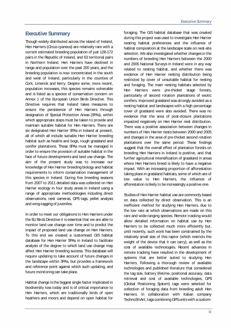


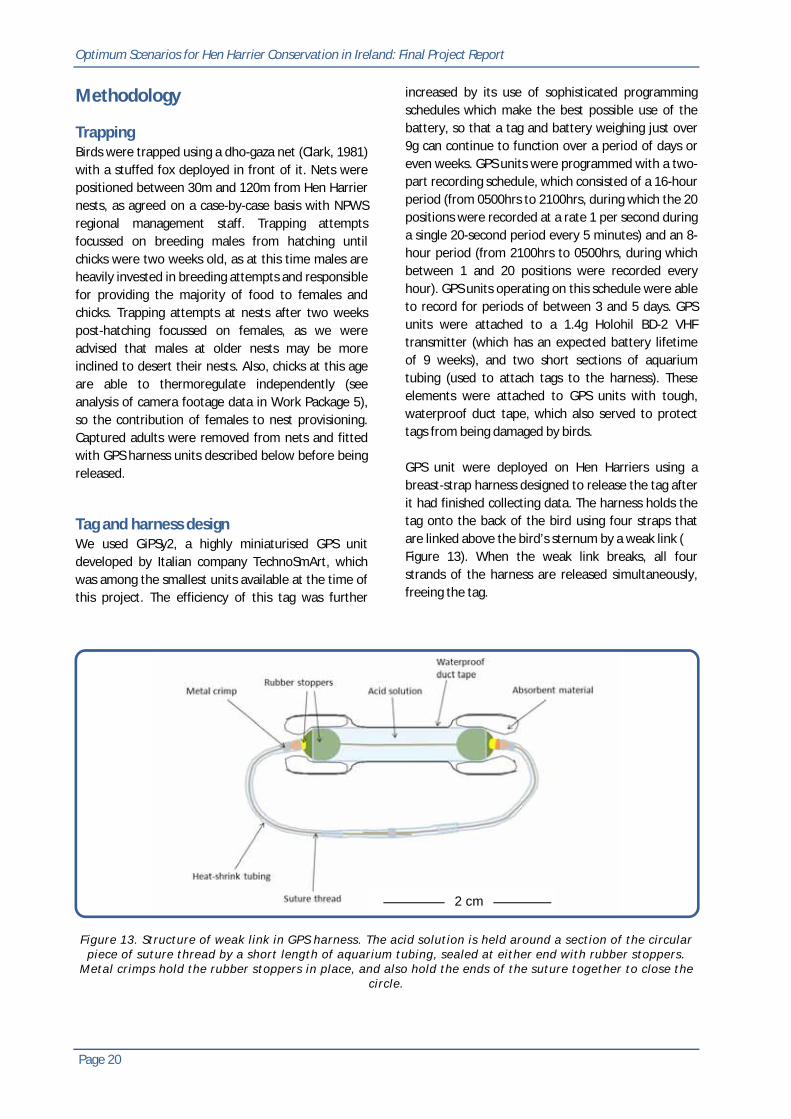
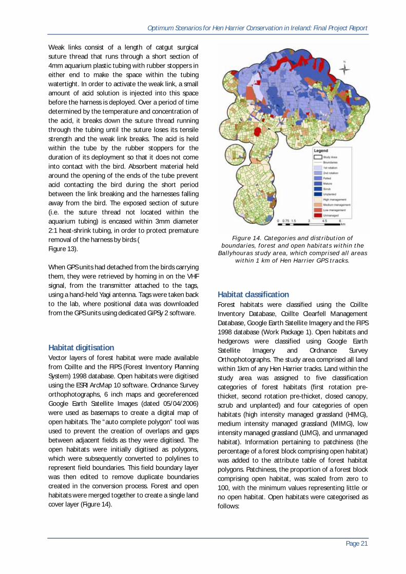


![Harrier [Crowood]](https://static.documents.pub/doc/80x56/577cd3b91a28ab9e789768ff/harrier-crowood.jpg)


