OPTIONS FOR FLOODS AND DROUGHT PREPAREDNESS IN BANGLADESH Dr Nehal Karim 1 Abstract: Bangladesh is a small country of 147,570 sq. km. with a huge population, the density of population is 855 per sq. km. and it has a low per capita income of US$ 386 per annum. It is one of the most natural disaster prone countries in the world. Over the last 30 years and especially after 1989 drought, 1991 cyclone, 1998 flood a methodology has been developed on the basis of considerable experiences and expertise in managing a wide range of disaster relief operations and measures to reduce vulnerability of disaster. Like other disaster floods and drought are also major natural disasters which Bangladesh experiences almost regularly. As Bangladesh remains primarily a rural country with almost 80% population living in rural area. Floods and drought mostly occur in Bangladesh silently or invisibly. Floods cause severe economic and social disruption to many people, specially living in flood prone areas. Like floods, the country faces unpredictable drought hazards in the dry monsoon due to inadequate and uneven rainfall. Though it varies from place to place, however, North-Western region suffers most from the drought. The main theme of this paper is to draw options for floods and drought preparedness in the context of Bangladesh. Key Words: Flood-proofing, Vulnerable, Community FLOOD PREPAREDNESS Current Status and Trends Historically, the population of Bangladesh lived with floods and adapted accordingly. Homesteads were built, as far as practicable, on higher parts of land free of flooding. Alternatively, strategies such as building houses on stilts or easily moveable buildings were also used. The traditional varieties of rice had evolved to grow in the flood conditions, which also brought fish. Transport was by boat. Over the last few decades with increasing urbanization and growth, many aspects of traditional life have changed. Homesteads have been more frequently constructed on land vulnerable to flooding. Many more roads have been constructed and now are vulnerable to floods. Considerable investment has been made in flood control 1 Nehal Karim, Ph.D, Professor of Sociology, University of Dhaka, Bangladesh, Phone No.: ++88-02-8618185, Fax: ++88-02-8615583, e-mail: [email protected]
Transcript
OPTIONS FOR FLOODS AND DROUGHT PREPAREDNESS IN BANGLADESH Dr Nehal Karim1 Abstract: Bangladesh is a small country of 147,570 sq. km. with a huge population, the density of population is 855 per sq. km. and it has a low per capita income of US$ 386 per annum. It is one of the most natural disaster prone countries in the world. Over the last 30 years and especially after 1989 drought, 1991 cyclone, 1998 flood a methodology has been developed on the basis of considerable experiences and expertise in managing a wide range of disaster relief operations and measures to reduce vulnerability of disaster. Like other disaster floods and drought are also major natural disasters which Bangladesh experiences almost regularly. As Bangladesh remains primarily a rural country with almost 80% population living in rural area. Floods and drought mostly occur in Bangladesh silently or invisibly. Floods cause severe economic and social disruption to many people, specially living in flood prone areas. Like floods, the country faces unpredictable drought hazards in the dry monsoon due to inadequate and uneven rainfall. Though it varies from place to place, however, North-Western region suffers most from the drought. The main theme of this paper is to draw options for floods and drought preparedness in the context of Bangladesh. Key Words: Flood-proofing, Vulnerable, Community
FLOOD PREPAREDNESS
Current Status and Trends Historically, the population of Bangladesh lived with floods and adapted accordingly. Homesteads were built, as far as practicable, on higher parts of land free of flooding. Alternatively, strategies such as building houses on stilts or easily moveable buildings were also used. The traditional varieties of rice had evolved to grow in the flood conditions, which also brought fish. Transport was by boat. Over the last few decades with increasing urbanization and growth, many aspects of traditional life have changed. Homesteads have been more frequently constructed on land vulnerable to flooding. Many more roads have been constructed and now are vulnerable to floods. Considerable investment has been made in flood control
1 Nehal Karim, Ph.D, Professor of Sociology, University of Dhaka, Bangladesh, Phone No.: ++88-02-8618185, Fax: ++88-02-8615583, e-mail: [email protected]
works which have blocked traditional monsoon navigation routes and road construction has further worsened this aspects.
Flood preparedness includes the following components:
• Organizations to respond to calamities in accordance with pre-established procedures
• Manpower, materials and emergency supplies available for allocation to afflicted areas
• Forecasting of floods and dissemination of warning to enable the potentially afflicted people to take mitigating measures
• Design and construction of basic infrastructure to be flood-resistant (GoB:1997)
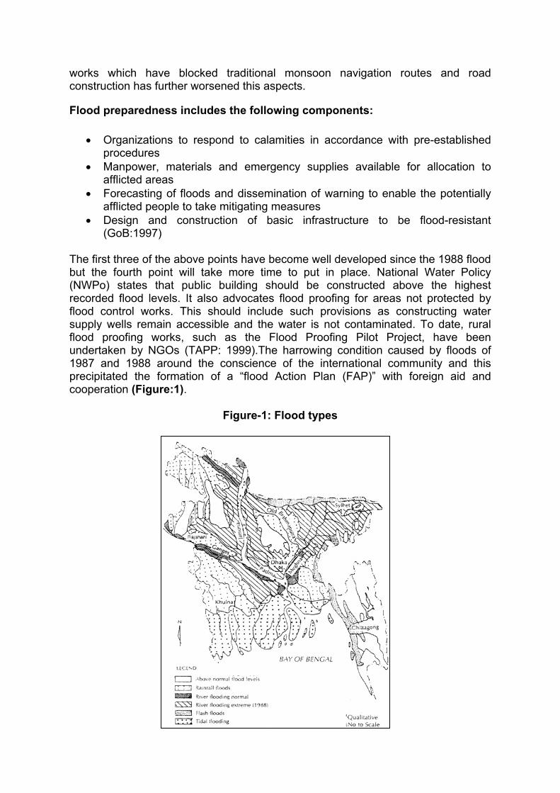
The first three of the above points have become well developed since the 1988 flood but the fourth point will take more time to put in place. National Water Policy (NWPo) states that public building should be constructed above the highest recorded flood levels. It also advocates flood proofing for areas not protected by flood control works. This should include such provisions as constructing water supply wells remain accessible and the water is not contaminated. To date, rural flood proofing works, such as the Flood Proofing Pilot Project, have been undertaken by NGOs (TAPP: 1999).The harrowing condition caused by floods of 1987 and 1988 around the conscience of the international community and this precipitated the formation of a “flood Action Plan (FAP)” with foreign aid and cooperation (Figure:1).
Figure-1: Flood types
Later on in 1998 despite the prolonged flood, for some reason, no standing order was made and no disaster warning formally issued. As a result, the disaster management strategy was not formally implemented. This indicates that while local people devise survival strategies, the overall nature of disaster response remains unfocussed.
Assessment of Needs Local people in flood prone areas are relatively attuned to flood. In 1998, however, many households were inundated who were not prepared for the deluge and the flood remained for a longer period, with the result that considerable stress was placed on residents and the ability of traditional strategies to cope with the hardship. The study recorded how people cope with flood by erecting macha (bamboo platforms), constructing bamboo walkways in front of doors and entrances of houses, taking refuge on embankments, storing food and fuel, by cooking/eating less food, and by surviving on dry food. Income and occupation adjustment strategies mentioned in consultations include distress sales, procuring relief, borrowing money from formal and informal sources and changing profession. There was no mention of crop losses incurred in 1998 flood. In 1992 as well, respondents to FAP 14 surveys outlined similar list of needs:
• Better access to storm and flood warning, emergency shelter, cooking fuel, safe drinking water and sanitation, access to food, cooking and eating facilities, animal care and fodder supply.
• Protection of crops and pond fish • Timely inputs in order to plant on time, or in case of loss, re-plant crops • Repair of infrastructure (homes, road, embankment) and • Access to health care facilities.
The degree to which these needs will be met in the future will be determined both by community preparedness and more locally specific, flood forecasting measures (GoB: 1995).
OPTIONS FOR DEVELOPMENT
Community Level Measures for Flood Preparedness A major strategy to alleviate impacts of flooding would begin at local level. Through joint community planning, floods that might be caused either by a sudden collapse or overtopping of embankments could be anticipated and measures taken to avoid
the necessity for emergency relief. Such activities could be encouraged nationally through wide-spread media campaigns. Subsidies of community-based flood-proofing measures (e.g. housing clusters/grain storage facilities/health care facilities etc.), could be provided, on condition that freely contributed labour be a proportion of community contribution and earth be provided by landowners whose land will become fish ponds free of charge. (To facilitate the task, mechanical dredging equipment might need to be brought in). Reliable water supply and sanitation facilities for men and women would also need to be installed in a flood proofed site, accessible from each para by agreed access routes (rivers or roads) in the event of a sudden flood. This could be operated and maintained by local paras (are with cluster of houses) at their own expense, again with the capital investment cost provided and allocated through local government as an incentive. In this case, the basic flood proofing would have to be carried out using local resources as proof of the community’s commitment to creating a flood proofed site within the village. Additionally, in particular flood prone areas, community buildings could be designated as flood refuges for both men and women, with special provisions made for the protection of vulnerable groups especially young girls. These would replace the currently precarious and unsustainable use of embankments as flood refuges. Such buildings would be fitted out with water supplies, sanitary facilities and basic medical facilities. As many women cannot take advantage of refuges for a variety of social and cultural reasons, the need for such a refuge and its management structure should be decided by local discussion on the basis of a consensus of opinion reached between men and women. Locally managed stores for food and fodder could be planned and community members asked to contribute to emergency rations to be placed in these stores in advance of the monsoon season (CDL:1990). As noted earlier, local communities have given top priority to the raising of roads and general flood proofing of country roads. Innovations in embankment design could be undertaken to devise stronger and more durable flood protection to rural and peri-urban infrastructure and roads could be placed at a considerable distance from the embankments to protect the movement of goods and people on these critical thoroughfares. This would help to alleviate the economic and commercial hiatus, which accompanies a flood and causes such distress to low-income families.
Flood forecasting Flood forecasting will need in the future to be oriented towards communities at risk not only from embankment failure or overtopping but at risk from flash flooding and also, people living in areas prone to prolonged water logging. For flood warnings in the monsoon season in areas where river and excessive rainfall are the cause of flooding, the warning system could be revamped to
communicate information from Flood Forecasting and Warning Centre (FFWC) directly to Disaster Management Committees and residents using shortwave radio/ or telephone. These can be used to broadcast warnings to volunteers/media centers or Grameen rural centers, etc. At community level, communities can also be encouraged to develop a local communication network to inform people of the problem using local dialect/mosque megaphones/colour coded warning signals in centers, etc, as well as mobile phones, Grameen Rural Phone networks can also be used in markets to communicate to other rural centers where mobile phones are used, so that word of the impending flood can spread quickly. Meanwhile, flood forecasting agencies can attempt to improve the lead time on flood warnings so that women can prepare fodder and food before the advent of the flood and save their livestock (GoB: 1996).
Planned Projects Work is already under way to improve the technical aspects of flood preparedness. A 5-year DANIDA funded project “Consolidation and Strengthening of Flood Forecasting and Warning Service” is expected to commence in January 2003 and includes the following objectives:
• Consolidation and capacity building; • Upgrade of hardware and software systems; • Upgrade of model set-ups applied including expansion of extent and
enhanced GIS applications; • Development of flood forecast and inundation modelling for all flood prone
areas of the country; • Expanded supermodel of all flood prone areas providing at least 50 flood
forecast points; • Improved rainfall forecasting system within Bangladesh using satellite
information, BMD and SPARRSO data; • Increased forecast lead-time by extensive training on better interpretation of
remote sensing and bilateral agreement with BMD for rainfall forecasts outside Bangladesh;
• Expand river data collection network to cover all flood prone areas of the country;
• Further development of dissemination services. The role envisaged for the Disaster Management Bureau needs to be clarified since it is identified as the focal point for dissemination. A Flood Preparedness Programmed is also currently under preparation by UNDP which will focus on training, public education/awareness and community mobilization. It will be essential that the two projects work closely together, particularly in the area of flood warning dissemination (GoB: 1994).
Flood Proofing of Infrastructure The National Water Policy has advocated greater emphasis on flood proofing. To date this has been undertaken by NGOs and an issue is whether and how GoB should support flood proofing. Should GoB have its own flood proofing projects or provide support to NGOs to continue with community level programmes? Should individuals be able to obtain subsidies to flood proof their own building? The community level approach is the most attractive, particularly in rural areas. NWPo requires that infrastructure and public buildings be constructed above the highest recorded flood levels. If this philosophy is applied then such works will become progressively more flood proofed as they are built or reconstructed. In addition to reducing damage and disruption during floods, these works can serve as flood refuges in times of emergency. It is less clear whether this approach must also be applied within urban areas which have flood protection, but to do so would reduce their vulnerability. Any works which may serve as flood refuges should have available water supply and sanitation facilities, with more specific attention given to issues of access and safety of women and children. Consideration must be given during the design and construction of embankments, for either roads or flood protection (or both) for their potential role as flood refuges. Widening of embankments to provide flood-proofed land for housing may be more cost-effective than raising nearly flood-proofed areas. However, due attention must be made to ensure that embankments do not increase flooding by impeding the passage of water.
Flood Proofing of Agriculture Traditional deep water (floating) flood rice is a flood compatible crop, which develops as the flood water rises. Unfortunately, it is not very high yielding and in some areas, pressure has been on farmers to grow higher-yielding but less flood tolerant varieties. This is not possible everywhere, however. In areas prone to flood, many farmers continue to grow local transplanted aman, or even deepwater aman, as their main rice crop. Some farmers also interplant different rice varieties so that they will get some crop whatever the flood conditions. Protection of farmland has been one of the main reasons for the past programmed of rural FCD schemes. However, the risk of embankments failing, public cuts, or water from internal rainfall not being able to drain away, has given rise to crop loss as the shorter-stemmed rice varieties and drowned. This risk of crop failure means that farmers are unwilling to invest heavily in crop inputs for monsoon season crops. There would be considerable advantage in devoting more agricultural research into improving the yields of the local rice varieties, which tolerate various levels of flooding and hence make agriculture less vulnerable to flood losses.
Forecasting and Information Dissemination A planned project to improve the existing flood forecasting and warning system has been described above. There are a number of related aspects, which may not be specifically covered by this project. A National Water Management Plan Project (NWMPP) comparison of the major floods on the Brahmaputra in Bangladesh against the E1 Nino/Southern Oscillation (ENSO) index has shown no significant correlation. However, it s possible, within the NWMP planning horizon, that improved understanding of global and regional weather patterns and their driving forces may enable reasonable predictions to be made of medium-term weather conditions. Improved local communications and dissemination of information would mean that not only flood forecasts be made easier to relate to local conditions, but also that the risk of embankment breaches and areas consequently at risk would become better known.
Review of Option Flood proofing is a combination of structural and non-structural options. If used together, they can substantially reduce the losses and distress, which regularly occur during and after the annual floods. In conjunction with support to make activities more flood proof, relief will be used more sparingly.
DROUGHT PREPAREDNESS
Current Status and Trends Every year Bangladesh experiences drought for 7 months, from November to May, when rainfall is normally low. During the 1998-1999 dry season, there was no rainfall at all for several months in some areas of the NW, the SW and Central Zones (Figure:2). This drought caused severe stress to both crops and fruit trees particularly in areas where water cannot be pumped from the shallow aquifer due to dropdown or increased salinity. However, the progressive development of groundwater for both water supplies and agriculture has meant that drought is not the major threat that it used to be. Dry season agriculture has been the main source of increased food production over the past 20 yeas (BBS: 1998).
Figure-2: Drought prone areas February to May 1990
During the last 50 years, Bangladesh is suffered about 20 times from drought conditions. The more important drought affected year was 1989 and so was in 1994-95. The persistent drought condition in NorthWestern (NW) Bangladesh in recent decades had led to shortfall of rice production of 3.5 million tones in the 1990s (Rahman and Biswas: 1995). See Figure:3.
Figure-3: Drought prone areas July to October 1990
However, increasing competition for groundwater and particularly drawdown of the groundwater below the suction limit for the domestic water supply hand pumps, means that there are still hardships in the dry season. Farmers also have the risk that their irrigation pumps will go dry before their crops are ready for harvest. Predictions of the effects of global climate change suggest that the dry seasons will become drier and hotter. Reduced rainfall would become the normal condition, although drought cannot become more severe once the rainfall reaches zero, except that higher temperatures increase water requirements. Relatively dry periods can also occur during the monsoon season and either a delayed start or an early finish to the monsoon rains can have significant implications for agriculture. At present there is no system for forecasting droughts although FFWC prepare low flow records for the major rivers. Records of groundwater levels show that below-average monsoon rainfall may not fully replenish the groundwater. This can be used to forecast above-average draw down of water levels during the following dry season. However, there is currently no system to collect and analyze post-monsoon groundwater level information quickly and disseminate the findings.
ASSESSMENT OF NEEDS The study has highlighted the problems with domestic water supplies during the dry season. However, this is a regular event and during drought, the situation is aggravated.
Options Drought is, to some extent, an annual event. So what is needed for drought preparedness to handle the exceptional rather than the normal conditions?
• A system for monitoring groundwater levels, particularly at the end of the monsoon season, which could then be used to forecast whether the water may drop below the pumping limits. The data is already being collected and the need is to communicate, analyze and disseminate the results quickly.
• Forecasting of medium-term weather so that exceptional droughts can be forecast with reasonable certainty.
• Establish procedures for reaction to actual or forecast exceptional drought with its implications for domestic water supplies and agricultural production.
• A mechanism to ensure that, under extreme conditions, priority is given to maintenance of supply for water for drinking.
• Identification of zones where drought is a possible risk • Zoning of areas according to the causes of and severity of the drought risk
(Karim: 1990).
The provision of drought-resistant domestic water supplies can be considered as drought-proofing rather than drought-preparedness. There is very little difference between the work needed to provide security of supply for the normal dry season conditions and for exceptional drought conditions if already there is need is for a change from a suction mode hand pump for normal conditions. A NWMPP comparison of drought conditions in Bangladesh against the E1 Nino/Southern Oscillation (ENSO) index has showed no significant correlation. However, it is possible that improved understanding of global weather patterns and their driving forces within the NWMP planning horizon may enable reasonable predictions to be made of medium term weather conditions.
Review of Option Even during droughts, Bangladesh has substantial groundwater resources and some flows in the three major rivers. Drought will become less of a problem provided systems are in place to ensure firstly, safe water for human consumption and, secondly, water for other uses. The underlying problem in the dry season is the increasing demand for water to meet, directly and indirectly, the various human needs of an increasing population. While severe drought is not yet a predictable event, it is more quantifiable than floods, and therefore more easily planned for, because the worst, but very improbable, case is zero rain for the whole of the dry season.
Bangladesh : Major Natural Disasters Year Type Disaster Deaths 1969-70 Drought + 1986-84 Drought + 1965-66 Drought in West Bengal, present + 1871 Floods (Rajshahi) + 1873-74 Drought 1885 1892 1896-97
1906-7 Floods in East Bengal 175,000 1918 Floods + 1922 Floods + 1943-44 Drought, irregular rain, transport
And War, includes West Bengal + 3,000.00
1955 Floods + 1972 Floods +
1974 Floods followed by famine 30,000 1975 Floods + 1978-79 Drought + 1982 Drought 2 1984 Floods + 1987 Floods 1,657 1988 Floods 2,379 1989 Drought + 1998 Floods lasting for nearly there months
covering 65% of land area 1000
CONCLUSION The flood in Bangladesh is a regular phenomenon and it is obvious that total flood control is not possible in our country. Because of the settlement pattern, people will continue to live outside protected areas and comprehensive planning and implementation of flood proofing measures can reduce the negative impact of floods and improve their standard of living. Lessons learned from the different flood proofing pilot projects will help the agencies involved in flood management to strengthen their programmes and to develop a range of flood proofing measures that would allow people living in those flood environments to improve their household livelihood security. From the above stated over-view on flood, it has been seen that drought is a recurrent feature of North-Western Bangladesh in recent decades. The reasons are related to both physical factors, such as, climatic anomalies affecting precipitation and drainage system of the basin areas, as well as impact of human population in terms of over irrigation by drawing sub-surface water, diversion of river water-both within and outside Bangladesh, deforestation, over cultivation etc. leading to excessive exposure of top-soil during dry season or in periods of low rainfall. However, to combat the drought, it is essential for Bangladesh to utilize its water resources, both surface and groundwater. Moreover, Bangladesh has increasing used her groundwater resources to such an extent that the depletion of groundwater resources as well as arsenic contamination is occurring at alarming rate in the groundwater resources due to over unplanned withdrawal.
REFERENCE: BBS (1998) Statistical Year Book of Bangladesh, 1999, Dhaka, Bangladesh CDL (1990) Flood\s in Bangladesh, Dhaka, Bangladesh GoB (1994) Standing Orders for Disasters (draft), Disaster Management Bureau (DMB), Dhaka, Bangladesh GoB (1995) FAP-14, Flood Response Study, Ministry of Water Resources, Dhaka, Bangladesh
GoB (1996) Summary on Loss and Damage of Cyclone of 1991, Flood of 1988, Drought of 1994 and Facts on Distribution of Relief, Ministry of Disaster Management and Relief, Bangladesh Secretariat Karim, Z et.al (1990) Drought in Bangladesh Agriculture and Irrigation Schedule for Major Crops, BARC Pub. No. 34, Dhaka, Bangladesh. Rahman, A and Biswas, P.R. (1995) Drought Devours Resources, Dhaka Courier, Bangladesh, 11(42). TAPP (1999) Support to Comprehensive Disaster Management Project, May, Dhaka, Bangladesh.