22
CORS/OPUS: Status & Future Prospects Richard Snay, Gerald Mader, & Neil Weston NOAA’s National Geodetic Survey CORS Users Forum 44 th CGSIC Meeting Long Beach, CA September 21, 2004

CORS/OPUS:Status & Future Prospects
Richard Snay, Gerald Mader, & Neil Weston
NOAA’s National Geodetic Survey
CORS Users Forum
44th CGSIC Meeting
Long Beach, CA
September 21, 2004

Continuously Operating
Reference Stations

CORS OVERVIEW
• Network contains 850+ sites as of Sep. 2004
• Growing at rate of 8 sites per month
• More than 130 organizations participate in the
CORS program
• Provides code range (C/A, P1, P2)
– and carrier phase observations (L1, L2)
• Provides meteorological data at some sites

CORS APPLICATIONS
• Postmission Static Positioning (cm-level
accuracy with a few hours of data, dm-level
accuracy with one minute of data)
• Postmission Kinematic Positioning (dm-level
accuracy for an aircraft, a boat, or a land vehicle)
• Geophysics / Crustal Motion
• Meteorology / Water Vapor in Atmosphere
• Space Weather / Free Electrons in Ionosphere

CORS Accomplishments
in FY 2004
• NGS orbits improved by 50% (8cm 4cm)
• NOAA‟s Forecast Systems Lab provides hourly
models for tropo delay
• OPUS accepts non-RINEX data files
• CORS West becomes operational
• Plate Boundary Observatory funded
• UFCORS offers „same-day‟ service

Accomplishments - continued
• NGS generates comprehensive map of 3-D
velocities for CONUS
• NGS and NOAA‟s Space Environment
Center develop capability to model the
distribution of free electrons in the
ionosphere
• OPUS enables users to select Coop CORS
sites for control stations

Accomplishments - continued
• National CORS network rapidly
approaching 500-station milestone
• Cooperative CORS network rapidly
approaching 100-station milestone
• NGS develops new software to
(1) manage CORS metadata
(2) monitor site status, and
(3) monitor data collection
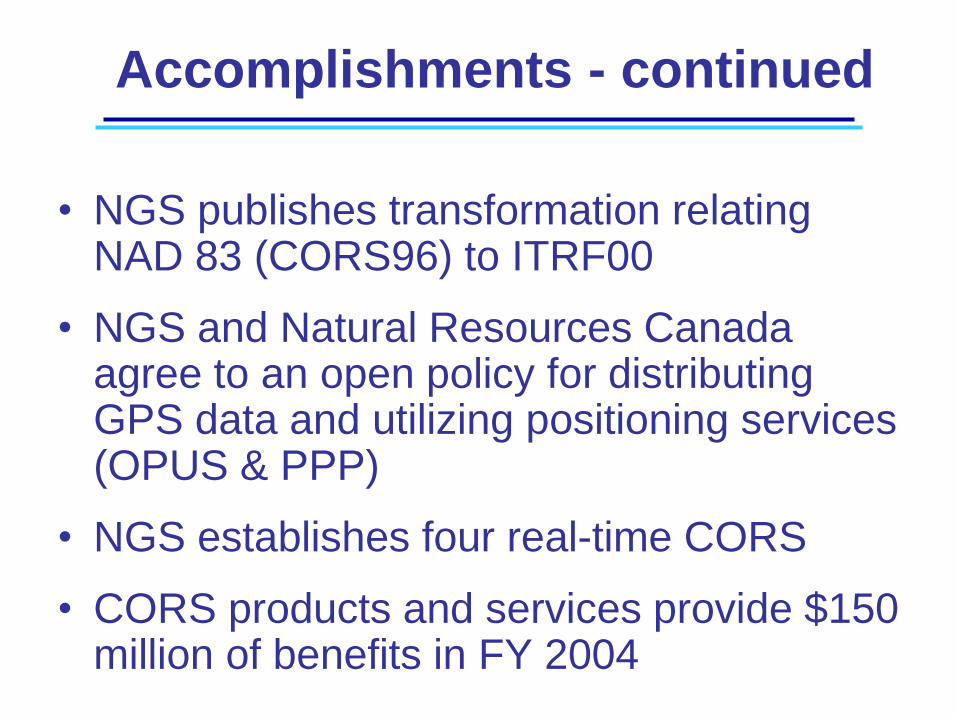
Accomplishments - continued
• NGS publishes transformation relating NAD 83 (CORS96) to ITRF00
• NGS and Natural Resources Canada agree to an open policy for distributing GPS data and utilizing positioning services (OPUS & PPP)
• NGS establishes four real-time CORS
• CORS products and services provide $150 million of benefits in FY 2004

Accolades
• GeoWorld magazine recognized OPUS as its Internet Resource of the month for March 2004
• Mark Meade published the article, “CORS: Still a national asset” in the September 2004 issue of Point of Beginning (POB) magazine

What is OPUS?
• Provide GPS users easier access to the
National Spatial Reference System
(NSRS).
• Direct connections to CORS network
• Consistency and reliability
• Intended for use in the conterminous U.S.
and territories.
It is NGS policy to not publish geodetic coordinates outside the
U.S. without the agreement of the affected countries.

How Does OPUS Work?• Submit GPS data files to NGS
– Through NGS web site – Uses NGS computers and software– Processed with respect to 3 CORS sites– Reported back to you via email in a few minutes
• Completely automatic - minimal information from user
– email address where you want the results sent – data file that you want to process
• Rinex or raw receiver formats• Multiple files in zipped/compressed format
– antenna type– height of the Antenna Reference Point (ARP)– Options
• state plane coordinate code• Specify CORS base stations• Extended output

Quick Link to OPUS
from NGS Home Page
www.ngs.noaa.gov


OPUS allows the antenna type, antenna height, SPC code, selected base stations and
extended option choices that you have just identified to be assigned to the email address
that you have entered. These entries & selections will be saved and used for your next
OPUS submission, saving time for multiple or repetitive submissions using the same
equipment and options configuration. When your profile is set, you will only need to
enter your email address and your data file and then upload. Your profile will
automatically supply the saved entries. When you data is finished uploading, the upload
page will display your profile entries.
To change and reset your profile, complete all the main page entries to gain access again
to the options page. You may also elect to delete your profile. (Hint: You might use
different email alias’s to identify different equipment and processing configurations that
you frequently use)
● Set / Reset my profile ○ Delete my profile
User Profile Option

OPUS solutions meeting certain criteria and
accompanied by metadata describing the site may
be eligible for publication as Data Sheets in the
NGS Integrated Data Base (NGSIDB). Users
submitting OPUS solutions to the NGSIDB must be
registered with NGS to receive a user ID and
password and agree to the terms of this
publication.
Option to Archive OPUS Results in NGS
Data Base under Consideration

OPUS – coming attractions
• Differential Range Solutions (2005)
– Meant to enhance handheld GPS
– Address GIS community
• Single Frequency Solutions (2005)
– Requires ionosphere modeling

How Does OPUS Compute Errors?
EW
S
Npeak-to-peak distances
1 σ standard deviation
peak-to-peak error
more conservative~ 2 σ
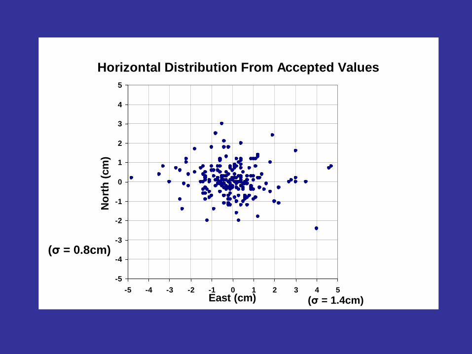
Horizontal Distribution From Accepted Values
-5
-4
-3
-2
-1
0
1
2
3
4
5
-5 -4 -3 -2 -1 0 1 2 3 4 5
East (cm)
No
rth
(cm
)
(σ = 0.8cm)
(σ = 1.4cm)

Vertical Distribution From Accepted Values
0
5
10
15
20
25
30
35
40
45
50
-6 -5 -4 -3 -2 -1 0 1 2 3 4 5 6
Difference (cm)
Nu
mb
er
(σ = 1.9cm)
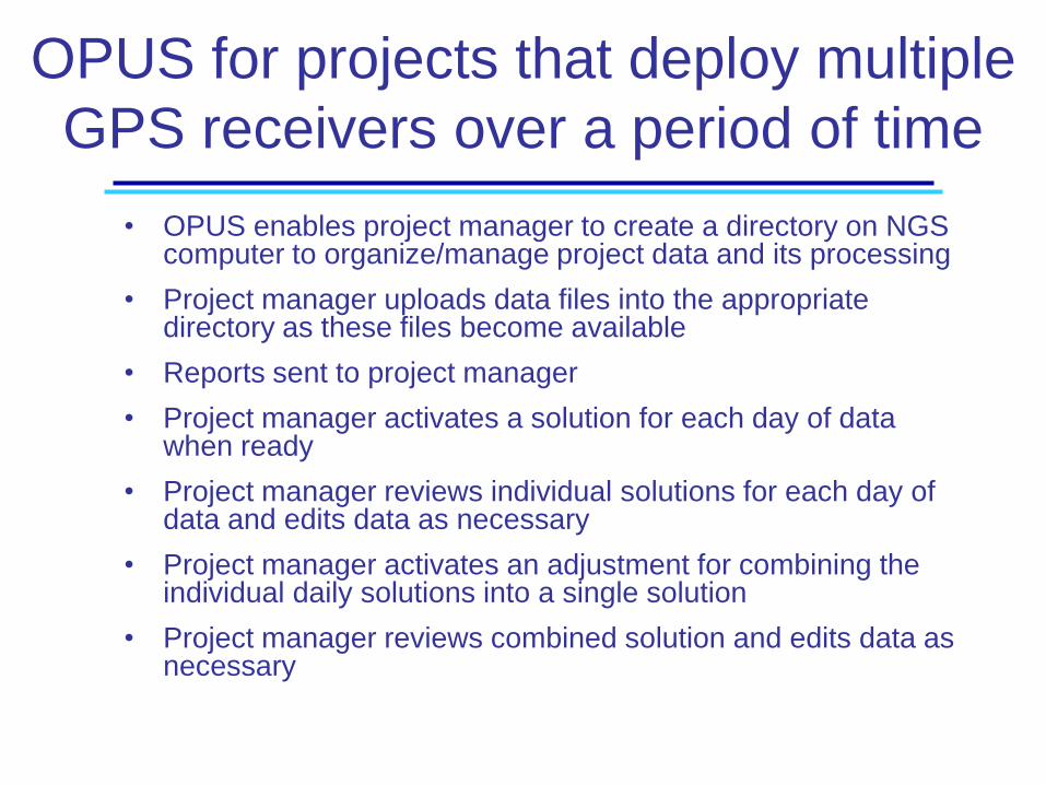
OPUS for projects that deploy multiple
GPS receivers over a period of time
• OPUS enables project manager to create a directory on NGS computer to organize/manage project data and its processing
• Project manager uploads data files into the appropriate directory as these files become available
• Reports sent to project manager
• Project manager activates a solution for each day of data when ready
• Project manager reviews individual solutions for each day of data and edits data as necessary
• Project manager activates an adjustment for combining the individual daily solutions into a single solution
• Project manager reviews combined solution and edits data as necessary

www.ngs.noaa.gov
OPUS ergo sum!


