72
ORCHARD GROVE Neighbourhood Concept Plan Stage 2 Report: Book 1- Planning Land Use Policies & Design Guidelines January 2012

ORCHARD GROVE Neighbourhood Concept Plan
Stage 2 Report: Book 1- Planning Land Use Policies & Design Guidelines
January 2012
Orchard Grove Neighbourhood Concept Plan
Contents
Introduction 1
Plan Area: Existing Neighbourhood 3
Foundation: Grandview Heights General Land Use Plan 4
Public Consultation 6
Vision and Guiding Principles 7
Key Land Use Features Identified in the Grandview Heights
GLUP 8
Sustainability 9
Placemaking 12
Grandview Heights Heritage & Environmental Assessment 15
Interface with Existing and Planning Neighbourhoods 16
Overview of Land Use Plan and Design Guidelines 18
Residential Land Uses and Design Guidelines 20
Large Lot Single Family or Large Lot Duplex 21
Small Lot Single Family w/wo Coach House 26
Single Family or Townhouse with Tree Preservation 31
Townhouse 33
Townhouse or Multi-Family with Tree Preservation 40
Multi-Family 42
Mixed-Use, Commercial & Residential Land Use & Design
Guidelines 49
Parks and Open Space – Land Use & Design Guidelines 56
Stormwater Detention Pond-Land Use & Design Guidelines 60
Special Streetscapes 62
Land Consolidation Areas 64
Population and Unit Dwelling Projections 66
Community Services and Amenities 67
Implementation Procedures 69
Acknowledgements: The City of Surrey Orchard Grove NCP team included: Catherina Lisiak (Project Manager), Nicholas Lai, Ron Hintsche,
Heather Kamitakahara & Stuart Jones of the Planning & Development Department; Sorina Mirea, Jeff Arason, Jeannie Lee & Mirjana Petrovic of
the Engineering Department; & Ted Uhrich of the Parks, Recreation & Culture Department.

Orchard Grove Neighbourhood Concept Plan 1
Introduction
The objective of this document is to outline the desired future land uses in Neighbourhood Area 5A of Grandview Heights in South Surrey called Orchard Grove. This document describes the proposed land use designations and accompanying policies, design and development guidelines that include place making and character defining elements. Together, these elements are intended to establish the foundation for the creation of a healthy and sustainable neighbourhood. Figure 1, the Land Use Concept Plan, has been developed through extensive consultation with the Citizen’s Advisory Committee (CAC), City staff, project consultants, other stakeholders and the public. The intent of this concept plan is to guide the development of a compact, environmentally friendly, and sustainable community.

Orchard Grove Neighbourhood Concept Plan 2
Figure 1:

Orchard Grove Neighbourhood Concept Plan 3
Plan Area: Existing Neighbourhood
The Orchard Grove NCP area is bounded by 164 Street to the West, 26 Avenue to the North, 168 Street to the East and 24 Avenue to the South. It contains 53 individual properties and approximately 30 hectares (76 acres) (Figure 2). The entire NCP area is currently designated Suburban in Surrey's Official Community Plan (OCP), and the majority of properties are zoned One-Acre Residential (RA).
Figure 2:

Orchard Grove Neighbourhood Concept Plan 4
Foundation: Grandview Heights General Land Use Plan
The Grandview Heights General Land Use Plan (GLUP) (Figure 3), approved by Council in 2005 provides the overall framework to guide the development, servicing and build-out of Orchard Grove as a comprehensively planned community. THE GLUP envisages Grandview Heights:
• “...as a complete community with a mix of residential densities, small commercial nodes, community facilities, schools, parks, pathways, trees and protected areas.”
The GLUP provides principles for consideration during the preparation of individual Neighbourhood Concept Plans (NCPs). In particular, the Vision and Guiding Principles developed for the Orchard Grove NCP builds upon Section 4.4 Sustainable Development Practices in the GLUP that states:
• “As Grandview Heights presents an ideal opportunity to implement principles of sustainability by
introducing standards and development practices consistent with global and regional sustainability objectives, detailed planning for the Grandview Heights area will incorporate principles of sustainable development, which are to be given attention in the development of the NCPs.”
• “The detailed NCP process for the five NCP areas in Grandview Heights will be expanded to explore
innovative servicing, storm water management, road standard and neighbourhood planning ideas.” The GLUP defines the boundaries for six separate NCP areas (Figure 3). Surrey City Council authorized the preparation of a Terms of Reference for the Orchard Grove NCP in Grandview Heights on July 28, 2008. Council approved NCP Area 1 -Morgan Heights in September 2006 and NCP Area 2- Sunnyside Heights in November 2010.

Orchard Grove Neighbourhood Concept Plan 5
Figure 3:

Orchard Grove Neighbourhood Concept Plan 6
Public Consultation
Planning for Orchard Grove began in the fall of 2008 and has been guided by a Citizens’ Advisory Committee (CAC). The CAC is a group of 16 residents and community association representatives. The planning process has included consultation with other area stakeholders and has been coordinated by City of Surrey staff. A start-up public open house was held on October 15, 2008, and a CAC was formed. On November 24, 2009, staff held a public open house to present two working draft land use options, including a preferred draft land use option proposed for the Orchard Grove NCP. As a result of the feedback from the open house, staff worked with stakeholders and area residents to make refinements to the plan in order to resolve outstanding issues concerning the plan. On July 20, 2010, staff held a third public open house to present a Draft Preferred Land Use Plan for Orchard Grove. Feedback from the public open house was reviewed and a Stage 1 Land Use Concept was forwarded to Council for consideration on September 13, 2010. A final public open house was held on November 29, 2011. Final changes to the land use plan were presented and feedback was incorporated prior to finalizing the Stage 2 component of the Plan. The planning process for the Orchard Grove NCP has included:
• Six meetings with the CAC, including two design workshops early in the planning process;
• Four public open houses held on October 18, 2008, November 24, 2009, July 20, 2010 and November 29, 2011; • Inter-agency referrals to Fisheries and Oceans Canada (DFO), Ministry of Transportation and Infrastructure
(MOTI), TransLink, Fraser Health Authority, Metro Vancouver, School District No. 36, Semiahmoo First Nation, Katzie First Nation, RCMP Surrey Detachment, FortisBC, BC Hydro, Surrey Board of Trade and the Surrey Fire Department; and
• Numerous discussions with internal and external stakeholders and area residents.

Orchard Grove Neighbourhood Concept Plan 7
Vision and Guiding Principles
Orchard Grove will contribute to creating a complete and sustainable City made up of quality, vibrant and inclusive neighbourhoods with a high degree of amenity and sensitivity to the natural environment by (Figure 4):
• Ensuring sensitive integration and connection with adjacent existing and planned neighbourhoods. • Fostering the creation of a high quality and walkable public realm that contributes to a unique
neighbourhood character & identity. • Exploring opportunities for providing local every day services and local employment for residents. • Fostering the creation of a neighbourhood that is inclusive, safe, healthy and diverse. • Providing opportunities for public recreation and social interaction. • Preserving valued habitat and natural open space. • Ensuring the greatest protection of ecological resources.
Figure 4:

Orchard Grove Neighbourhood Concept Plan 8
Key Land Use Features Identified in the Grandview Heights GLUP
The Grandview Heights GLUP identifies the following key land use features in Orchard Grove in order to guide future development of this area (Figure 5):
• A substantial landscape buffer along 26 Avenue between 164 Street and 166 Street. • A central North-South Street with a significant Greenway and Habitat Corridor running from 26 Avenue to 24
Avenue connecting North to an existing greenway in NCP 5 and connecting South to the Sunnyside NCP. • A multi-use pathway running along 24 Avenue and connecting West to the Morgan Heights NCP and East to
Future NCP 5. • A sensitive interface and density transition along 26 Avenue and 168 Street with the Suburban designated lands
to the North and East. • A mixed use, residential and commercial area identified at the intersection of 24 Avenue and 168 Street in the
Sunnyside NCP.
Figure 5:

Orchard Grove Neighbourhood Concept Plan 9
Sustainability
Sustainability principles and features have been incorporated into the Orchard Grove NCP. The key features of a sustainable community include the promotion of a range of densities to reduce the footprint of development and to provide for a transit-friendly and walkable neighbourhood. The network of pedestrian-oriented and human scale streets will create a safe and walkable community. The NCP framework provides for walkability and inter-connection, places for community gathering and social interaction, diversity of housing form and tenure, and protection of biodiversity through retention of mature trees. These elements are described below.
Examples of Sustainability Elements (Photos taken at Dockside Green, Victoria, BC)
Orchard Grove Neighbourhood Concept Plan 10
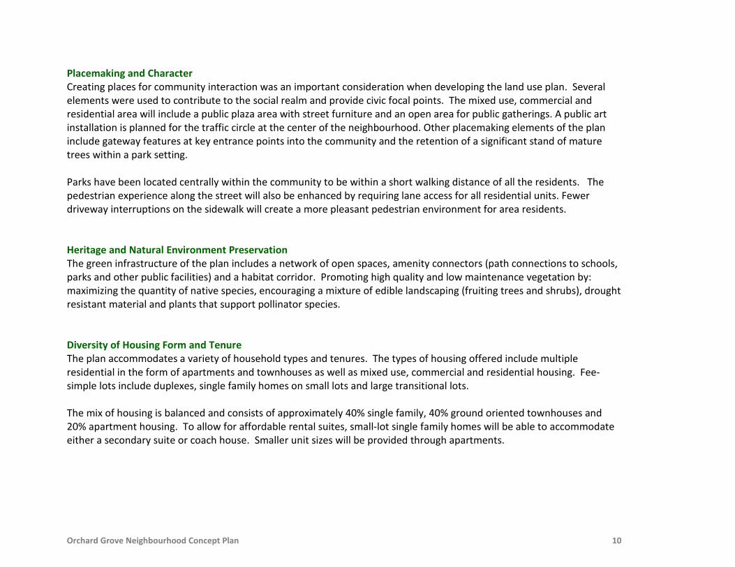
Placemaking and Character Creating places for community interaction was an important consideration when developing the land use plan. Several elements were used to contribute to the social realm and provide civic focal points. The mixed use, commercial and residential area will include a public plaza area with street furniture and an open area for public gatherings. A public art installation is planned for the traffic circle at the center of the neighbourhood. Other placemaking elements of the plan include gateway features at key entrance points into the community and the retention of a significant stand of mature trees within a park setting. Parks have been located centrally within the community to be within a short walking distance of all the residents. The pedestrian experience along the street will also be enhanced by requiring lane access for all residential units. Fewer driveway interruptions on the sidewalk will create a more pleasant pedestrian environment for area residents. Heritage and Natural Environment Preservation The green infrastructure of the plan includes a network of open spaces, amenity connectors (path connections to schools, parks and other public facilities) and a habitat corridor. Promoting high quality and low maintenance vegetation by: maximizing the quantity of native species, encouraging a mixture of edible landscaping (fruiting trees and shrubs), drought resistant material and plants that support pollinator species. Diversity of Housing Form and Tenure The plan accommodates a variety of household types and tenures. The types of housing offered include multiple residential in the form of apartments and townhouses as well as mixed use, commercial and residential housing. Fee-simple lots include duplexes, single family homes on small lots and large transitional lots. The mix of housing is balanced and consists of approximately 40% single family, 40% ground oriented townhouses and 20% apartment housing. To allow for affordable rental suites, small-lot single family homes will be able to accommodate either a secondary suite or coach house. Smaller unit sizes will be provided through apartments.

Orchard Grove Neighbourhood Concept Plan 11
Employment Opportunities The Orchard Grove NCP area is located in close proximity to the Grandview Corners/ Morgan Crossing Shopping Centre, consisting of approximately 92,900 square metres (one million square feet) of commercial space and the Highway 99 Corridor Local Area Plan. This Local Area Plan is primarily planned for Commercial and Business Park uses with approximately 6,000 new jobs at full build out. Given the close proximity to the Commercial and Business Park areas, the Orchard Grove NCP includes a small scale neighbourhood mixed use, commercial and residential area. The residential areas in the NCP will support these employment lands. Connectivity and Transportation Choice Transportation choice, including the possibility to walk, bike and use transit as alternative modes to car use are important components of creating complete and sustainable communities. A robust local road network designed to be safe for cycling and a multi-use trail along 24 Avenue will provide good cycling connections within the Orchard Grove NCP and beyond to other neighbourhoods in Grandview Heights. The plan provides for an inter-connected, fine-grained street network. This grid structure provides increased options to disperse traffic and avoid congestion. On average, block sizes are approximately 100 metres (328 feet) by 200 metres (656 feet). These block sizes promote walkability since pedestrians are able to avoid circuitous routes and reach destinations more directly.
A Flex Street (24A Avenue), a Green Street (167 Street) and a Special Commercial Street (167A Street) have been introduced into the plan in order to provide connectivity while responding to site-specific challenges. These streets provide flexibility by allowing for a variation in the alignment and cross-section so that public connections through the sites are possible. The Green Street design will ensure that the existing Douglas Fir trees on this street are retained. Green Building Green buildings and infrastructure will be promoted by recommending that all developments follow LEED (Leadership in Energy and Environmental Design) certification. The LEED Certification process uses a points-based rating system to assess building and site design against recognized sustainable measures and standards in the areas of sustainable sites, water efficiency, materials and resources, and indoor environmental quality.

Orchard Grove Neighbourhood Concept Plan 12
Placemaking Considerations
Several elements have been proposed to reinforce identity and to create a sense of place in the Orchard Grove NCP. There are opportunities for placemaking within the parks and open spaces, gateway features, the square in the mixed use site as well as the roads and designated walking and cycling routes. The proposed street network is a fundamental element where the majority of daily public interactions occur. An important component of the placemaking for this neighbourhood will be the protection of natural heritage by preserving forested areas and the remnant orchard farm.
Public Art in the Traffic Circle As a key pedestrian and vehicle route and the heart of Orchard Grove, a public art installation is planned for the traffic circle at the intersection of 166 Street and 25 Avenue. The installation will be funded by the Private Development Public Arts Program. The theme may be influenced by the orchard heritage in the neighbourhood. The design and construction details will be determined at the development application stage.
Public Art and Landscaping in a Traffic Circle (Photos taken at South Surrey Recreation Centre)

Orchard Grove Neighbourhood Concept Plan 13
Parks, Open Space and Natural Heritage The parks, open space and the preservation of natural heritage are central to creating a high quality, accessible and inclusive place. In particular, the development in Orchard Grove will build upon the following principles:
• Safety and inclusion by using best practices in Crime Prevention Through Environmental Design (CPTED) with
development fronting onto parkland and public open space. For example, residential units adjacent to the central park will require that the front of buildings face the park and have direct front door access to the park. This concept of "eyes on the park" will allow for natural surveillance and will ensure that the park spaces are safe for users throughout the day.
• Multi-tasked open space and access for all modes of transportation. The design of the parks will consider multi-uses including community gardening and other forms of food production that will have the ability to build food security and create a sense of community for the area residents. Bicycle parking, benches and trails will ensure that non-motorized travel is promoted in this area.
• Preserve natural features including trees stands identified in the 2008 Environmental Assessment and Tree
Survey. Square in the Mixed Use, Commercial and Residential Area The mixed use, commercial and residential area will include a space for a neighbourhood square and a public gathering space. This space is envisioned as a destination where the community gathers to socialize and take part in various activities. Amenities in this area may include seating, public art, outdoor cafes and activity spaces for community and cultural programming. In addition, the street network surrounding the mixed use area will be modified to a Special Commercial Street to improve the public realm by featuring on-street parking pockets, traffic calming, special pavement treatment and enhanced sidewalks.
Orchard Grove Neighbourhood Concept Plan 14
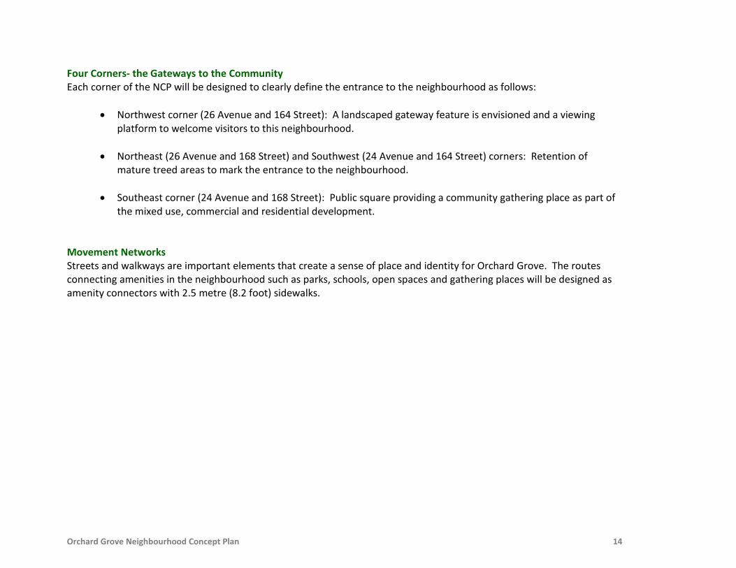
Four Corners- the Gateways to the Community Each corner of the NCP will be designed to clearly define the entrance to the neighbourhood as follows:
• Northwest corner (26 Avenue and 164 Street): A landscaped gateway feature is envisioned and a viewing platform to welcome visitors to this neighbourhood.
• Northeast (26 Avenue and 168 Street) and Southwest (24 Avenue and 164 Street) corners: Retention of mature treed areas to mark the entrance to the neighbourhood.
• Southeast corner (24 Avenue and 168 Street): Public square providing a community gathering place as part of the mixed use, commercial and residential development.
Movement Networks Streets and walkways are important elements that create a sense of place and identity for Orchard Grove. The routes connecting amenities in the neighbourhood such as parks, schools, open spaces and gathering places will be designed as amenity connectors with 2.5 metre (8.2 foot) sidewalks.

Orchard Grove Neighbourhood Concept Plan 15
Grandview Heights Heritage and Environmental Assessment
The land use plan for Orchard Grove has been developed to reflect and protect the heritage and natural environmental features of this area. Grandview Heights Heritage Study As part of the planning process for the Grandview Heights GLUP, a Heritage Study was prepared in 2005 by Donald Luxton and Associates to identify the historic sites in Grandview Heights and opportunities for heritage preservation. The historical trajectory of the area after European contact has been logging, followed by agriculture, and then rural residential development. A notable agricultural use was the growing of fruiting trees such as apple-pears and cherries. The study found that there are no heritage buildings in Orchard Grove; however, the study recommended that there were opportunities to celebrate the natural heritage of this area by using historical road and pioneer family names as well as preserving historical landscapes such as windbreaks, remnant orchards and specimen trees. Environmental Assessment and Tree Survey In 2008, an Environmental Assessment and Tree Survey were carried out by Madrone Consulting. The study provided an up-to-date inventory of all the vegetated areas, sensitive ecosystems, potential wildlife linkages, and other ecologically important features. There are no fish bearing watercourses in Orchard Grove NCP; however, several high value tree stands and associated wild-life values were identified. Building on the findings of the Environmental Assessment Report and the Heritage Study, the following natural heritage protection areas have been incorporated in the Land Use Concept Plan:
• Tree preservation on public property by the acquisition of an one hectare (2.3 acre) forested area consisting of high value Douglas Fir trees exceeding 30 metres (100 feet) in height.
• Promoting tree preservation on private property by offering density incentives when important tree clusters are protected.
• Commemoration and retention of a portion of a two hectare (5 acre) apple-pear orchard farm. • Promoting fruiting trees and vegetation on private property in order to establish a link to the agricultural past
of this area.

Orchard Grove Neighbourhood Concept Plan 16
Interface with Existing and Planned Neighbourhoods
The land use plan for Orchard Grove has been developed to be compatible with the existing and planned surrounding land uses (Figure 6).
164 Street - West Interface with the Morgan Heights NCP
The land uses proposed on 164 Street in Orchard Grove are planned to mirror the existing land uses across 164 Street such that small lot single family lots are planned between 26 and 25 Avenue, and townhouses are planned between 25 and 24 Avenue.
168 Street - East Interface with future NCP 5
The lands East of 168 Street are currently rural residential in character with larger homes on larger lots and substantial tree cover. Tree preservation along 168 Street is proposed to interface with current and future land uses.
24 Avenue - South Interface with the Sunnyside NCP To complement the proposed uses in the Sunnyside NCP, the highest residential densities and a small mixed use, commercial and residential area, are proposed on 24 Avenue within Orchard Grove. To help provide connectivity across 24 Avenue, key North-South roads have been aligned to allow connections to the North side (165, 166 and 167 Streets). Signalized intersections will be at 164 and 168 Streets.
26 Avenue - North Interface with future NCP 5 The lands North of 26 Avenue are estate residential in character consisting of larger homes on large lots. To respond to this existing sensitive interface, the proposed form and character of this interface will include a substantial landscape buffer along 26 Avenue and a lower density built form.

Orchard Grove Neighbourhood Concept Plan 17
Figure 6:

Orchard Grove Neighbourhood Concept Plan 18
Overview of the Land Use Plan and Design Guidelines
The Orchard Grove NCP outlines the desired future land uses. It is proposed to be a complete community that includes a range of residential housing forms, employment opportunities and preservation of natural heritage on a modified grid street network. Together, these elements are intended to establish the foundation for the creation of a healthy, affordable and special place to live and play. The NCP is consistent with the Vision and Guiding Principles and Grandview Heights GLUP as noted above. The key features and land use components are:
• A range of street-oriented and human-scale residential land uses including large lot single family, large lot duplex, small lot single family, townhouses and multi-family.
• A mixed use, commercial and residential area providing opportunities for public gathering and a community meeting place.
• Two parks including the protection of an one hectare (2.3 acre) forested area and the incorporation of the existing apple-pear orchard farm in the future development of this area.
• A Multi-Use Trail along 24 Avenue and amenity connectors providing transportation choice in the neighbourhood.
• A Habitat Corridor connecting North to an existing greenway and South to a proposed elementary school. • A landscape buffer on 26 Avenue to help transition between suburban and urban residential land uses. • A robust local road network providing increased connectivity in the neighbourhood. • A traffic circle with a public art installation at the center of the neighbourhood. • A Residential Flex Street, a Green Street and a Special Commercial Street promoting sustainability and
placemaking within the public realm of the neighbourhood. The following sections describe the land use designations, policies and design guidelines related to specific land uses. The purpose of the design guidelines is to achieve a pedestrian-friendly, high quality and coordinated neighbourhood that is consistent with the principles and objectives of sustainable development. The design guidelines describe the dominant characteristics that will be encouraged in these areas. Issues addressed by the guidelines include the relationship of buildings to streets, built form and character, and design considerations for crime prevention. These guidelines, along with Surrey’s Official Community Plan (OCP), the Grandview Heights General Land Use Plan and Surrey’s Zoning By-law will be used to guide development in Orchard Grove NCP. These guidelines will be used by City staff to guide the applicants in

Orchard Grove Neighbourhood Concept Plan 19
coordinating the design among individual development applications and to ensure that the desired neighbourhood character is achieved. For single family development, the design guidelines will be implemented through Building Schemes. Building Schemes will be approved by the City, registered on the lots and administered by design consultants hired by the applicants of each development site. For all other developments including duplexes, townhouses, multi-family and mixed use, commercial and residential developments, the design guidelines will be implemented through Development Permits. To avoid the isolation of any individual properties as development proceeds in the NCP area, consolidation will be required for the properties as shown on Figure 13. Further information regarding land consolidation requirements is located in the Land Consolidation Areas section of this document. For areas where a minimum land assembly is not required, concept plans may be required to demonstrate how adjacent properties can be developed with the intent that no properties are unduly isolated.

Orchard Grove Neighbourhood Concept Plan 20
Residential Land Uses and Design Guidelines
Approximately 18 hectares (45 acres) of Orchard Grove is proposed for residential use with a variety of densities and housing forms. The mix of housing is balanced and consists of approximately 40% single family, 40% ground oriented townhouses and 20% apartment housing. The residential land use designations are based on “net” density calculations. The guidelines for residential land uses promote the development of a range of housing types, densities, and forms that will provide a variety of housing options while ensuring a strong and unified character for the neighbourhood. The provision of a variety of housing types and densities from single family to apartments is intended to provide a range of housing choices for people across the spectrum of incomes and family types, and provide options for residents to remain in the neighbourhood as they age. Overall, the highest residential densities are located adjacent to 24 Avenue and decrease towards 26 Avenue. At full build out, it is projected that the Plan area will have between 700 and 1200 dwelling units. Site planning and landscaping for residential development should take into consideration principles of Crime Prevention Through Environmental Design (CPTED) by including opportunities for neighbourhood surveillance of pathways, corridors and parks.

Orchard Grove Neighbourhood Concept Plan 21
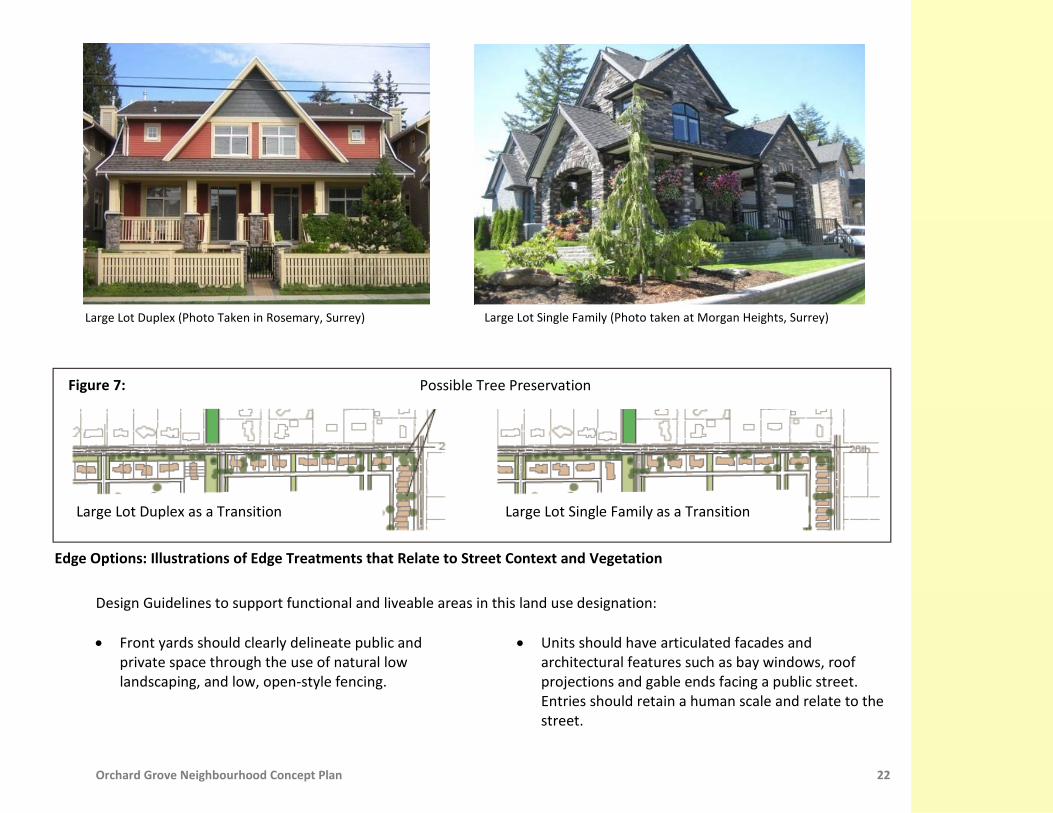
Large Lot Duplex or Large Lot Single Family The lowest residential densities, 2 to 10 units per acre (upa), are proposed along 26 Avenue as a transition to the form and character of the development across the street. Flexibility is provided to allow for large single family lots or large duplex lots, provided that the form and character already established on 26 Avenue is maintained (Figure 7). Where duplex lots are proposed, Development Permits are required in order to ensure that the form and massing of the proposed duplex units maintain the large lot single family character established North of 26 Avenue.
Existing Character-North Side of 26 Avenue (Photos taken at Orchard Grove)
Orchard Grove Neighbourhood Concept Plan 22
Design Guidelines to support functional and liveable areas in this land use designation: • Front yards should clearly delineate public and
private space through the use of natural low landscaping, and low, open-style fencing.
• Units should have articulated facades and architectural features such as bay windows, roof projections and gable ends facing a public street. Entries should retain a human scale and relate to the street.
Large Lot Duplex (Photo Taken in Rosemary, Surrey)
Large Lot Single Family (Photo taken at Morgan Heights, Surrey)
Figure 7:
Large Lot Single Family (Photo taken at Morgan Heights, Surrey)
Large Lot Duplex as a Transition Large Lot Single Family as a Transition
Edge Options: Illustrations of Edge Treatments that Relate to Street Context and Vegetation
Possible Tree Preservation
Orchard Grove Neighbourhood Concept Plan 23
• Front porches and verandas with overhangs that define a semi-private area in front of the unit are strongly encouraged.
• Steep gable roofs and dormers are encouraged. • Dwelling units should be designed to ensure a
maximum amount of natural light to penetrate the unit.
• Use of permeable surfaces for driveways and other
paved areas is strongly encouraged. • Houses on corner lots will be architecturally unique,
and shall face the street on both sides. • Garages and ancillary structures must be accessed by
a rear lane.
• Identify, preserve and incorporate existing trees where possible.
• Promoting high quality and low maintenance vegetation by: maximizing native species and drought resistant material, and planting fruiting trees and shrubs that support pollinator species. The following variety of fruiting trees and plants is recommended based on the local growing conditions: apples, pears, cherries, plums, walnuts, hazelnuts, strawberries and gooseberries.
• Promoting high quality materials and finishes (eg. wood, stone, masonry). Vinyl siding as the primary cladding material is not permitted.
• Promoting green building including: sustainable site development, water and energy efficiency, materials selection and indoor environmental quality.
Public Walkway A 10 metre (33 feet) wide public walkway is required between 26 Avenue and 25A Avenue. For developments directly adjacent to a public walkway, the maximum permitted height of fences is 1.2 metres (4 feet). To provide for natural surveillance, large windows and activity rooms such as living and dining rooms are encouraged to be located facing walkways.

Orchard Grove Neighbourhood Concept Plan 24
Transition Landscape Buffer on 26 Avenue A 10 metre (33 feet) wide landscape buffer is required adjacent to 26 Avenue to provide a smooth transition to the larger estate residential lots to the North. The planting within this area will be comprised of a staggered double row of fruiting trees and flowering shrubs as well as a meandering walkway. To minimize disruption of the landscape buffer, no driveways are permitted on 26 Avenue. The landscape buffer will be secured through a combination statutory right-of-way and No-Build Restrictive Covenant registered on the title of the lots. Developments adjacent to the landscaped transition buffer on 26 Avenue should ensure that residential units will:
• Face the transition landscape buffer with direct pedestrian access to 26 Avenue. • Clearly delineate public and private space through the use of natural low landscaping, and low, open-style fencing,
no higher than 1.2 metres (4 feet). • Provide windows and activity rooms such as living and dining rooms facing the landscape buffer to provide natural
surveillance. On-Site Stormwater Controls On-site stormwater controls are required for all developments in the Orchard Grove NCP. Relying heavily on sustainable, landscaped-based stormwater source controls, the intent is to maximize infiltration and evapo-transpiration of rainwater. For single-family residential lots, a minimum depth of 300mm of enhanced or amended topsoil is to be applied to all yards and pervious areas. This is to ensure that a minimum level of infiltration and rainfall absorption is designed into the lot development. Roof leader drains are to be disconnected from the piped storm sewer system and discharged onto landscaped areas. Single-family residential lots are also encouraged to incorporate additional forms of on-site controls to minimize the impervious lot coverage associated with paved driveways, patios, and pathways. These on-site controls may include porous pavement, rain gardens, and retaining existing tree cover. Layout, configuration, and construction of these additional controls should be done in accordance with the City of Surrey’s Best Management Practices. The Engineer of Record is to verify in writing that the amended topsoil meets the requirements of the guidelines and has been property installed and that roof leaders discharge to the ground, not to a storm sewer.

Orchard Grove Neighbourhood Concept Plan 25
Summary of Requirements for Developments in the Large Lot Single Family or Large Lot Duplex Designation:
Large Lot Single Family Large Lot Duplex
Net Density 2 to 6 upa Up to 10 upa
Minimum Lot Depth 35 metres (115 feet) + 10 metre (33 feet) SROW for Transition Landscape Buffer where required.
Minimum Lot Width 24 metres (79 feet) 12 metres (39 feet) + 12 metres (39 feet) = 24 metres (79 feet)
Lane Access Required. No front driveways to the public street are permitted.
Coach House Not permitted.
Development Permit Not required. The design guidelines in this land use designation will be implemented through registered
Building Schemes administered by design consultants hired by the developers and
approved by the City.
Required and subject to the design guidelines noted above in this section of the document.
Minimum Land Assembly
Not required. Although minimum land assembly areas are not required, concept plans may be required to demonstrate how adjacent properties may be developed with the
intent that no properties are unduly isolated.
Interface Conditions Design criteria for development adjacent to a Public Walkway or the Landscape Transition Buffer on 26 Avenue are outlined above in this section of the document.

Orchard Grove Neighbourhood Concept Plan 26
Small Lot Single Family with or without Coach House Residential densities of 10 to 15 units per acre will allow for small lot single family development with or without coach housing (suites above or next to lane-access garages). This land use designation is intended to provide for single family residential homes in a more compact neighbourhood. Design Guidelines to support functional and liveable areas in this land use designation: • Front yards should clearly delineate public and
private space through the use of natural low landscaping, and low, open-style fencing.
• Units shall have articulated facades and architectural features such as bay windows, roof projections and gable ends facing a public street. Entries should retain a human scale and relate to the street.
• Front porches and verandas with overhangs that define a semi-private area in front of the unit are strongly encouraged.
• Steep gable roofs and dormers are encouraged. • Dwelling units should be designed to ensure a
maximum amount of natural light to penetrate the unit.
• Houses on corner lots will be architecturally unique,
and shall face the street on both sides.
• Garages, ancillary dwellings (coach houses) and structures must be accessed by a rear lane.
• Use of permeable surfaces for driveways and other paved areas is strongly encouraged.
• Identify, preserve and incorporate existing trees where possible.
• Promoting high quality and low maintenance
vegetation by: maximizing native species and drought resistant material, and planting fruiting trees and shrubs that support pollinator species. The following variety of fruiting trees and plants is recommended based on the local growing conditions: apples, pears, cherries, plums, walnuts, hazelnuts, strawberries and gooseberries.
• Promoting high quality materials and finishes (eg. wood, stone, masonry). Vinyl siding as the primary cladding material is not permitted.
• Promoting green building including: sustainable site development, water and energy efficiency, materials selection and indoor environmental quality.

Orchard Grove Neighbourhood Concept Plan 27
Coach Houses Suites above or next to lane-access garages are permitted in this designation provided that: • A minimum lot depth of 38 metres (125 feet) is achieved in
order to ensure sufficient on-site parking and outdoor amenity space.
• Two additional parking spaces are provided. • The coach house is setback 1.2 metres (4 feet) from the lane
in order to provide additional on-site parking opportunities and to avoid a canyon effect in the lane.
• Additional outdoor space, such as balconies is provided for
the inhabitants of the coach house.
• Steep gable roofs and dormers are incorporated. Most of the habitable space of the coach house should be contained within the roof gable to minimize massing.
• A minimum separation of 6 metres (20 feet) is provided between a coach house and the principal unit. Breezeway connections to the principal building are not permitted.
• Where a coach house is situated near a public street or entrance to a lane, the façade should be articulated to address both the public street and the lane. The number and size of windows should be maximized. The lots at the intersection of a public street should be 13 metres (43 feet) wide in order to allow sufficient landscaping and articulation of facades.
Coach House at the Intersection of a Public Street (Photo taken at Garrison Crossing, Chilliwack, BC)

Orchard Grove Neighbourhood Concept Plan 28
Public Walkways A 10 metre (33 feet) wide public walkway is required between 26 Avenue and 25A Avenue and along the South side of the Stormwater Detention Pond. For developments directly adjacent to a public walkway, the maximum permitted height of fences is 1.2 metres (4 feet). Large windows and activity rooms such as living or dining rooms are encouraged to be located facing walkways to provide for natural surveillance of these spaces. For residential units adjacent to the Stormwater Detention Pond, the development should face the walkway with the primary entrance from the walkway. Transition Landscape Buffer on 26 Avenue A 10 metre (33 feet) wide landscape buffer is required adjacent to 26 Avenue in order to provide a smooth transition to the larger estate residential lots to the North. The planting within this area will be comprised of a staggered double row of fruiting trees and flowering shrubs as well as a meandering walkway. To minimize disruption of the landscape buffer, no driveways are permitted on 26 Avenue. The landscape buffer will be secured through a combination statutory right-of-way and No-Build Restrictive Covenant registered on the title of the lots. Developments adjacent to the landscaped transition buffer on 26 Avenue should ensure that residential units:
• Clearly delineate public and private space through the use of natural low landscaping, and low, open-style fencing, no higher than 1.2 metres (4 feet).
• Provide large windows and activity rooms facing the landscape buffer in order to provide natural surveillance. Habitat Corridor Developments adjacent to the Habitat Corridor should ensure that residential units:
• Face the Corridor with direct pedestrian access; and • Clearly delineate public and private space through the use of natural low landscaping, and low, open-style fencing,
no higher than 1 metre (3 feet). Additional design criteria for the Habitat Corridor are located in the Townhouse section of this document.

Orchard Grove Neighbourhood Concept Plan 29
On-Site Stormwater Controls On-site stormwater controls are required for all developments in the Orchard Grove NCP. Relying heavily on sustainable, landscaped-based stormwater source controls, the intent is to maximize infiltration and evapo-transpiration of rainwater. For single-family residential lots, a minimum depth of 300mm of enhanced or amended topsoil is to be applied to all yards and pervious areas. This is to ensure that a minimum level of infiltration and rainfall absorption is designed into the lot development. Roof leader drains are to be disconnected from the piped storm sewer system and discharged onto landscaped areas. Single-family residential lots are also encouraged to incorporate additional forms of on-site controls to minimize the impervious lot coverage associated with paved driveways, patios, and pathways. These on-site controls may include porous pavement, rain gardens, and retaining existing tree cover. Layout, configuration, and construction of these additional controls should be done in accordance with the City of Surrey’s Best Management Practices. The Engineer of Record is to verify in writing that the amended topsoil meets the requirements of the guidelines and has been property installed and that roof leaders discharge to the ground, not to a storm sewer.

Orchard Grove Neighbourhood Concept Plan 30
Summary of Requirements for Developments in the Small Lot Single Family with or without Coach House Designation:
Small Lot Single Family with or without Coach House
Net Density 10 to 15 upa
Minimum Lot Depth
35 metres (115 feet). 38 metres (125 feet) where a coach house is provided.
Minimum Lot Widths
9 metres (30 feet) to 12 metres (39 feet) + 10 metre (33 feet) SROW for Transition Landscape Buffer where required.
13 metres (43 feet) for lots at the intersection of a public street where a coach house is
provided.
Lane Access Required. No front driveways to public street are permitted.
Coach House Permitted, subject to additional design considerations for coach houses as outlined in this section of the document.
Development Permit
Not required. The design guidelines in this land use designation will be implemented through registered Building Schemes administered by design consultants hired by the developers and
approved by the City.
Minimum Land Assembly
Not required. Although minimum land assembly areas are not required, concept plans may be required to demonstrate how adjacent properties may be developed with the intent that no
properties are unduly isolated.
Interface Conditions
Design criteria for development adjacent to the Landscape Transition Buffer on 26 Avenue or a Public Walkway are located above in this section of the document.
In addition to the design criteria in this section, additional design criteria for Habitat Corridors
are outlined in the Townhouse section of this document.

Orchard Grove Neighbourhood Concept Plan 31
Single Family or Townhouse with Tree Preservation Located at the eastern edge of the neighbourhood, this designation provides for a single family form that transitions from the existing rural residential housing form on the opposite side of 168 Street to higher densities within the neighbourhood. There are some mature coniferous trees of significant size in this area. A townhouse development form would allow for greater tree preservation at the corners of 25 and 26 Avenues, with higher density as an incentive for this type of development. To achieve the maximum density permitted in this designation at 15 units per acre, land assemblies and tree preservation on private property are required. Where land assemblies and tree preservation are not feasible, the maximum permitted density in this designation is 10 upa. The intent of this land use designation is to ensure that tree preservation is encouraged and the form of development responds to the site specific natural environmental characteristics of the site.
Tree Preservation in Townhouse Developments (Photos taken at Rosemary and Morgan Heights, Surrey)
Orchard Grove Neighbourhood Concept Plan 32
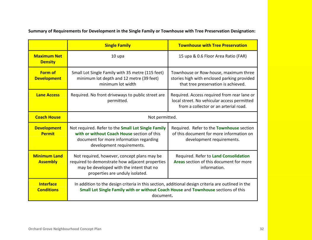
Summary of Requirements for Development in the Single Family or Townhouse with Tree Preservation Designation:
Single Family Townhouse with Tree Preservation
Maximum Net Density
10 upa 15 upa & 0.6 Floor Area Ratio (FAR)
Form of Development
Small Lot Single Family with 35 metre (115 feet) minimum lot depth and 12 metre (39 feet)
minimum lot width
Townhouse or Row-house, maximum three stories high with enclosed parking provided
that tree preservation is achieved.
Lane Access Required. No front driveways to public street are permitted.
Required. Access required from rear lane or local street. No vehicular access permitted
from a collector or an arterial road.
Coach House Not permitted.
Development Permit
Not required. Refer to the Small Lot Single Family with or without Coach House section of this document for more information regarding
development requirements.
Required. Refer to the Townhouse section of this document for more information on
development requirements.
Minimum Land Assembly
Not required, however, concept plans may be required to demonstrate how adjacent properties
may be developed with the intent that no properties are unduly isolated.
Required. Refer to Land Consolidation Areas section of this document for more
information.
Interface Conditions
In addition to the design criteria in this section, additional design criteria are outlined in the Small Lot Single Family with or without Coach House and Townhouse sections of this
document.

Orchard Grove Neighbourhood Concept Plan 33
Townhouse Residential densities of 15 to 30 units per acre in the form of townhouses and row-houses are proposed to be located in the interior of the plan area. The housing form built under the townhouse designation provides a suitable transition between the higher density multi-family housing to the South towards 24 Avenue and the lower density single family houses to the North towards 26 Avenue.
Photos taken at North Grandview Heights and Morgan Heights, Surrey
Orchard Grove Neighbourhood Concept Plan 34
Design Guidelines to support the development of functional and liveable areas in this land use designation: • Dwelling units should face the public street or lane
with direct pedestrian access. To encourage visual surveillance of public space, dwelling units should be designed to also address a walkway, Habitat Corridor or Park area that they are adjacent to or across from.
• Incorporate a habitable room associated with the front entrance for units facing a public street. Express a strong sense of individual entry by using a porch at the street level with weather protection over each entrance.
• Corner units exposed to side views should provide
sufficient architectural detailing in all street-fronting elevations.
• Emphasize the vertical expression of individual units. Break facades into smaller scale elements through the use of windows, bays, balconies and dormers. A block of no more than eight townhouse units is permitted.
• Dwelling units should be designed to ensure a maximum amount of natural light to penetrate the unit.
• Parking shall be provided in enclosed and secured garages attached to individual units or in secure underground parking. Tandem parking on end units is discouraged.
• Vehicular access shall be provided from a rear lane or from a well landscaped entrance off a local street. No vehicular access is permitted from a collector or an arterial road.
• Use of permeable surfaces for driveways and other paved areas is strongly encouraged.
• Rooftop decks and balconies are encouraged. • Fences are not desirable in the front yard area of
townhouse sites; shrubs and hedges are recommended. If fences are unavoidable, an open-style fence in combination with landscaping and a low stone or brick faced wall as a base is encouraged. Front yard fences should not be higher than 1 metre (3 feet).
• Common pedestrian access to adjacent walkways,
streets or the Habitat Corridor should be provided by clear, identifiable entryways differentiating between public and private lands. Permanently closed gates are not permitted.
• Outdoor and indoor amenity areas are required and should be located in close proximity to each other as well as centrally located to all residents. Where a site abuts the Habitat Corridor, the Corridor area may be used as the outdoor amenity area and considered as fulfillment of the outdoor amenity requirement.
Orchard Grove Neighbourhood Concept Plan 35
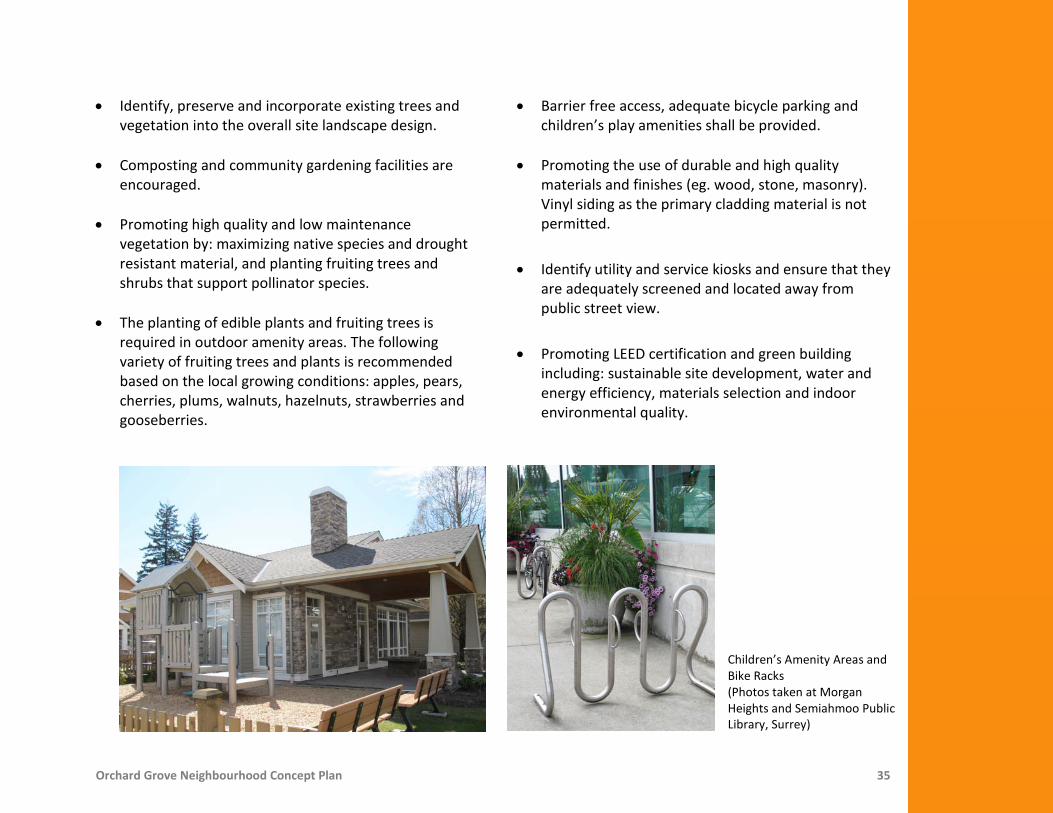
• Identify, preserve and incorporate existing trees and vegetation into the overall site landscape design.
• Composting and community gardening facilities are
encouraged. • Promoting high quality and low maintenance
vegetation by: maximizing native species and drought resistant material, and planting fruiting trees and shrubs that support pollinator species.
• The planting of edible plants and fruiting trees is
required in outdoor amenity areas. The following variety of fruiting trees and plants is recommended based on the local growing conditions: apples, pears, cherries, plums, walnuts, hazelnuts, strawberries and gooseberries.
• Barrier free access, adequate bicycle parking and children’s play amenities shall be provided.
• Promoting the use of durable and high quality
materials and finishes (eg. wood, stone, masonry). Vinyl siding as the primary cladding material is not permitted.
• Identify utility and service kiosks and ensure that they are adequately screened and located away from public street view.
• Promoting LEED certification and green building including: sustainable site development, water and energy efficiency, materials selection and indoor environmental quality.
Children’s Amenity Areas and Bike Racks (Photos taken at Morgan Heights and Semiahmoo Public Library, Surrey)

Orchard Grove Neighbourhood Concept Plan 36
Orchard Preservation and the Habitat Corridor The townhouse development fronting the 20 metre (66 feet) wide Habitat Corridor should look at opportunities to retain a portion of the existing orchard trees and incorporate the orchard trees into the outdoor amenity of any proposed development. The 20 metre (66 feet) wide Habitat Corridor will be secured through a combination statutory right-of-way and No-Build Restrictive Covenant registered on the title of the lots. Properties affected by the Habitat Corridor will be able to have this density transferred to the remaining portion of the lot. The Habitat Corridor will be constructed by the applicant of each development site and maintained by the strata corporation of each development site. The design will be regulated through the Development Permit approval process.
For portions of the Habitat Corridor that do not contain existing orchard trees, the planting will be comprised of a staggered double row of fruiting trees and flowering shrubs as well as a meandering walkway. Vegetation that contributes to foraging and nesting habitat for songbirds and provides opportunities for pollinator species is encouraged. To minimize disruption of the Habitat Corridor, no driveways are permitted to 166 Street.
Direct Pedestrian Access to Dwelling Unit through a Landscaped Area (Photo taken at Dockside Green, Victoria, BC)
Existing Apple-Pear Orchard (Photo taken at Orchard Grove)

Orchard Grove Neighbourhood Concept Plan 37
Developments adjacent to the Habitat Corridor should ensure that all proposed residential units will: • Face the Habitat Corridor with direct pedestrian access. In order to encourage public surveillance of the Habitat
Corridor, reduced setbacks may be considered for units fronting directly onto the Corridor. • Clearly delineate public and private space through the use of natural low landscaping. Fences are not desirable;
shrubs and hedges are recommended. If fences are unavoidable, a low and open-style fencing, no higher than 1 metre (3 feet) is encouraged.
• Provide windows and activity rooms facing the Habitat Corridor to provide natural surveillance. Public Walkway A 10 metre (33 feet) wide public walkway is required between 25A Avenue and 25 Avenue. For developments directly adjacent to a public walkway, the maximum permitted height of fences is 1 metre (3 feet). To provide natural surveillance, large windows and activity rooms such as living and dining rooms are encouraged to be located facing walkways.
Units Fronting directly onto a Pathway (Photos taken at Rosemary, Surrey)
Orchard Grove Neighbourhood Concept Plan 38
Public Art and the Traffic Circle As a key pedestrian and vehicle route at the heart of Orchard Grove, a 1,620 square metre (0.4 acre) traffic circle with a public art installation is planned for the center of the plan area. The public art installation will be funded by the Private Development Public Arts Program. The theme may be influenced by the orchard heritage in the neighbourhood. The detailed design and construction details will be determined through the development approval process. On-Site Stormwater Controls On-site stormwater source controls are required for all developments in the Orchard Grove NCP. Relying heavily on sustainable, landscaped-based stormwater source controls, the intent is to maximize infiltration and evapo-transpiration of rainwater. Multi-family residential developments are required to meet performance targets for on-site stormwater source controls. The recommended source control measures include:
• 300mm layer of enhanced or amended topsoil placed on all pervious areas of the site; • Absorbent landscaping that promotes the capture and retention of stormwater; • Infiltration galleries to provide a retention volume of 250 m3/ha of impervious area; and • Disconnected roof leaders that direct roof runoff to splash pads.
The specific mix of source control methods is up to each site owner to allow for integration into the site’s overall architectural and landscaping concept. Layout, configuration, and construction of these additional controls should be done in accordance with the City of Surrey’s Best Management Practices (BMPs). The Engineer of Record is to verify in writing that all BMPs have been designed in accordance with the Guidelines and properly installed.
Orchard Grove Neighbourhood Concept Plan 39
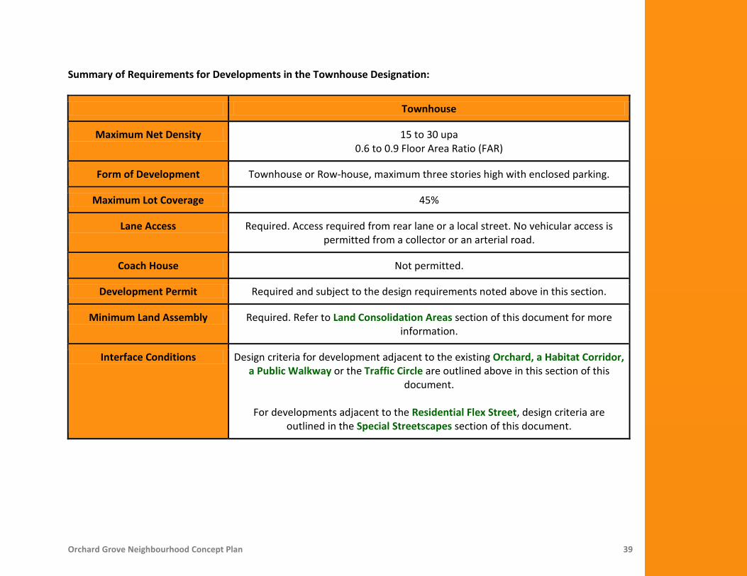
Summary of Requirements for Developments in the Townhouse Designation:
Townhouse
Maximum Net Density 15 to 30 upa 0.6 to 0.9 Floor Area Ratio (FAR)
Form of Development Townhouse or Row-house, maximum three stories high with enclosed parking.
Maximum Lot Coverage 45%
Lane Access Required. Access required from rear lane or a local street. No vehicular access is permitted from a collector or an arterial road.
Coach House Not permitted.
Development Permit Required and subject to the design requirements noted above in this section.
Minimum Land Assembly Required. Refer to Land Consolidation Areas section of this document for more information.
Interface Conditions Design criteria for development adjacent to the existing Orchard, a Habitat Corridor, a Public Walkway or the Traffic Circle are outlined above in this section of this
document.
For developments adjacent to the Residential Flex Street, design criteria are outlined in the Special Streetscapes section of this document.

Orchard Grove Neighbourhood Concept Plan 40
Townhouse or Multi-Family with Tree Preservation Located at the Southwest corner of the neighbourhood, this designation allows for either townhouses or multi-family residential development. Multi-family development with a higher density is the incentive for tree preservation at this gateway to the neighbourhood. Multi-family development would incorporate underground parking, with limited surface parking for visitors. To achieve the maximum density permitted in this designation at 30 units per acre, land assemblies and tree preservation on private property are required. Where land assemblies and tree preservation are not feasible, the maximum permitted density in this designation is 15 upa. The intent of this land use designation is to ensure that tree preservation is encouraged and the form of development responds to the site specific characteristics of the site.
Photos taken at Westbrook Place, UBC, Vancouver

Orchard Grove Neighbourhood Concept Plan 41
Summary of Requirements for Developments in the Townhouse or Multi-Family with Tree Preservation Designation:
Townhouse Multi-Family with Tree Preservation
Maximum Net Density 15 upa 0.6 Floor Area Ratio (FAR)
30 upa 0.9 Floor Area Ratio (FAR)
Form of Development Townhouse or Row-house, maximum three stories in height with enclosed parking.
Stacked Townhouses and Apartment Housing up to six stories high with
underground parking provided that tree preservation is achieved.
Maximum Lot Coverage
45%
Lane Access Required. Access required from rear lane or a local street. No vehicular access is permitted from a collector or an arterial road.
Coach House Not permitted.
Development Permit Required. Refer to the Townhouse section of this document for more information on design
requirements.
Required. Refer to the Multi-Family Residential section of this document for
more information on design requirements.
Minimum Land Assembly
Not required, however, concept plans may be required to demonstrate how adjacent
properties may be developed with the intent that no properties are unduly isolated.
Required. Refer to Land Consolidation Areas section of this document for more
information.
Interface Conditions For developments adjacent to the Multi-Use Trail on 24 Avenue, additional design criteria are outlined in the Multi-Family Section of this document.
For developments adjacent to the Residential Flex Street, design criteria are outlined in the
Special Streetscapes section of this document.

Orchard Grove Neighbourhood Concept Plan 42
Multi-Family The highest residential densities, 30-45 units per acre, are proposed along 24 Avenue and adjacent to the mixed use, commercial and residential area. These densities allow for a range of housing types from stacked townhouse units to apartment housing up to six stories high with underground parking.
Photos taken at Hawthorn Place, UBC, Vancouver and Morgan Heights, Surrey

Orchard Grove Neighbourhood Concept Plan 43
Design Guidelines to support the development of functional and liveable areas in this land use designation: • Units along a street frontage should have a strong
street-oriented character. Dwelling units should face the public street and units located on the ground floor shall have direct pedestrian access to the street to ensure a high degree of walkability.
• The massing and proportions of the buildings shall contribute to a human-scaled street edge through such means as porches, entryways, cornices and overhangs.
• Building facades should be articulated which clearly distinguish individual units while reinforcing a unified residential character.
• Dwelling units should be designed to ensure a maximum amount of natural light to penetrate the unit.
• Rooftop decks and balconies are encouraged.
• Parking shall be provided underground accessed from rear lanes, or from well landscaped entrances off local streets. No vehicular access will be permitted from a collector or arterial road.
• Private and public space should be clearly delineated,
without sacrificing opportunities for casual observation of public spaces.
• Fences are not desirable in the front yard areas of
multi-family sites; shrubs and hedges are recommended. If fences are unavoidable, an open-style fence in combination with landscaping and a low stone or brick faced wall as a base is encouraged. Front yard fences should not be higher than 1 metre (3 feet).
• Outdoor and indoor amenity areas are required and should be located in close proximity to each other as well as centrally located to all residents. Where a site abuts the Habitat Corridor, the Corridor area may be used as the outdoor amenity area and considered as fulfillment of the outdoor amenity requirement.
• Identify, preserve and incorporate existing trees and vegetation into the overall site landscape design.
• Promoting high quality and low maintenance vegetation by: maximizing native species and drought resistant material, and planting fruiting trees and shrubs that support pollinator species.
• The planting of edible plants and fruiting trees is required in outdoor amenity areas. The following variety of fruiting trees and plants is recommended based on the local growing conditions: apples, pears, cherries, plums, walnuts, hazelnuts, strawberries, and gooseberries.

Orchard Grove Neighbourhood Concept Plan 44
• Composting and community gardening facilities are encouraged.
• Barrier free access, adequate bicycle parking and children’s play amenities shall be provided.
• Provide a coordinated group of furnishings (bike racks, signs, benches and waste receptacles) to match the overall character of the development.
• Enclose loading and garbage areas within buildings, oriented away from public street view and provide overhead gates for security.
• Identify utility and service kiosks and ensure that they are adequately screened and located away from public street view.
• Incorporate measures to shield and mitigate noise generated from road traffic into buildings and developments that are near an arterial road.
• Promoting the use of durable and high quality
materials and finishes (eg. wood, stone, masonry). Vinyl siding as the primary cladding material is not permitted.
• Promoting LEED certification and green building including: sustainable site development, water and energy efficiency, materials selection and indoor environmental quality.
• Investigate opportunities for introducing geo-exchange heating and cooling systems.

Orchard Grove Neighbourhood Concept Plan 45
Multi-Use Trail on 24 Avenue The Multi-Use Trail on 24 Avenue (Figure 8) will accommodate a range of users and will connect the community to the Grandview Corners/Morgan Crossing Shopping Centre to the West and the future NCP 5 community to the East. The trail system will be accessible to all residents of the community through access points and will connect a variety of land uses, including residential areas.
The Multi-Use Trail will be a 4 metre (13 feet) wide paved meandering path, located within an 8 metre (26 feet) wide corridor on private property with trees and landscaping on either side. Existing trees and vegetation should be incorporated into the design of the trail where possible. Native vegetation and planting should be provided along either side of the pathway.
24 Avenue Multi-Use Corridor Cross Section
Figure 7:
Figure 8:

Orchard Grove Neighbourhood Concept Plan 46
The trail will be secured through a combination statutory right-of-way and No-Build Restrictive Covenant registered on the title of the lots. Properties affected by the trail will be able to have this density transferred to the remaining portion of the lot. The trail will be constructed by the applicant of each development site and maintained by the strata corporation of each site. The design will be regulated through the development approval process.
Seating areas should be provided at entrances to the trail by adjacent developments and maintained by the respective strata corporation. Seating should be placed in a manner that encourages both the visual surveillance of the trail as well as surveillance of the seating from the residential units.
The trail should be designed to encourage rainwater infiltration by using a permeable pavement surface or by ensuring runoff from the path flows onto a vegetated area. The path surface shall be designed to allow for use by bicycles, wheelchairs and strollers. The edges of the pathway should be well defined to avoid surface erosion and to reduce trail maintenance. Developments in this land use adjacent to a Park, Multi-Use Trail or Habitat Corridor should ensure that all proposed residential units will: • Face the Park, Multi-Use Trail or Habitat Corridor
directly with pedestrian access. To encourage public surveillance, reduced setbacks may be considered for units fronting directly onto a park, trail or corridor.
• Provide common pedestrian access to adjacent Parks, Multi-Use Trails and Habitat Corridors. The pedestrian access should have clear, identifiable entryways differentiating between public and private lands. Permanently closed gates are not permitted.
• Clearly delineate public and private space through the use of natural low landscaping. Fences are not desirable; shrubs and hedges are recommended. If fences are unavoidable, a low and open-style fencing, no higher than 1 metre (3 feet) is encouraged.
• Provide windows and activity rooms such as living or
dining rooms facing a park, trail or corridor.
• Provide pedestrian scale low-level lighting and wall mounted lighting on units adjacent to a park, trail or corridor.
Orchard Grove Neighbourhood Concept Plan 47
On-Site Stormwater Controls On-site stormwater controls are required for all developments in the Orchard Grove NCP. Relying heavily on sustainable, landscaped-based stormwater source controls, the intent is to maximize infiltration and evapo-transpiration of rainwater. Multi-family residential developments are required to meet performance targets for on-site stormwater source controls. The recommended source control measures include:
• 300mm layer of enhanced or amended topsoil placed on all pervious areas of the site; • Absorbent landscaping that promotes the capture and retention of stormwater; • Infiltration galleries to provide a retention volume of 250 m3/ha of impervious area; and • Disconnected roof leaders that direct roof runoff to splash pads.
The specific mix of source control methods is up to each site owner to allow for integration into the site’s overall architectural and landscaping concept. Layout, configuration, and construction of these additional controls should be done in accordance with the City of Surrey’s Best Management Practices (BMPs). The Engineer of Record is to verify in writing that all BMPs have been designed in accordance with the Guidelines and properly installed.

Orchard Grove Neighbourhood Concept Plan 48
Summary of Requirements for Developments in the Multi-Family Residential Designation:
Multi-Family Residential
Maximum Net Density 30 to 45 upa 0.9 to 1.3 Floor Area Ratio (FAR)
Form of Development Stacked Townhouses and Apartment Housing up to six stories high with underground parking.
Maximum Lot Coverage 45%
Lane Access Required. Access required from rear lane or a local street. No vehicular access is permitted from a collector or an arterial road.
Coach House Not permitted.
Development Permit Required and subject to the design requirements noted above in this section.
Minimum Land Assembly Required. Refer to Land Consolidation Areas section of this document for more information.
Interface Considerations Design criteria for development adjacent to the Multi-Use Trail on 24 Avenue are outlined above in this section of the document.
For developments adjacent to the Habitat Corridor, additional design criteria are
outlined in the Townhouse section of this document.
For developments adjacent to the Green Street or Special Commercial Street, design criteria are outlined in the Special Streetscapes section of this document.
Orchard Grove Neighbourhood Concept Plan 49
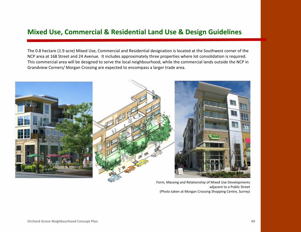
Mixed Use, Commercial & Residential Land Use & Design Guidelines
The 0.8 hectare (1.9 acre) Mixed Use, Commercial and Residential designation is located at the Southwest corner of the NCP area at 168 Street and 24 Avenue. It includes approximately three properties where lot consolidation is required. This commercial area will be designed to serve the local neighbourhood, while the commercial lands outside the NCP in Grandview Corners/ Morgan Crossing are expected to encompass a larger trade area.
Form, Massing and Relationship of Mixed Use Developments adjacent to a Public Street
(Photo taken at Morgan Crossing Shopping Centre, Surrey)

Orchard Grove Neighbourhood Concept Plan 50
This designation allows for a mixed use development form, with commercial and office store fronts located at ground level or the second floor and residential units above, up to six stories in height with underground parking. A public plaza that can serve as a community meeting place will be required to be incorporated into the development. This area is required to be pedestrian oriented in terms of street design as well as massing and orientation. Development in this land use designation is required to have a village-centre character with the following Design Guidelines:
• Provide a near continuous street frontage with
emphasis on the public realm through the use of compressed front setbacks along the street frontage, with the primary façade addressing the street. Create building forms with a strong street enclosure, particularly at corners.
• Pedestrian weather protection with a minimum width
of 1.8 metres (6 feet) shall be provided in the form of awnings or architectural overhangs on all ground-level commercial frontage facing the square and the surrounding public streets.
• Commercial units fronting onto the square and the
public streets shall be primarily glazed using see-through glass, and shall be directly accessed from the square or public street.
• Wall mounted lighting fixtures are encouraged on all
commercial developments. Decorative lamppost and luminaire lighting, designed for the pedestrian scale, should be used throughout the commercial area.
• Residential parking for the mixed use development shall be provided in underground garages. Limited commercial parking can be provided at street level.
• Parking should be accessed from the Special Commercial Street. No vehicular access is permitted from a collector or an arterial road.
• Signage and way finding should be integrated into the
design and detailing of the building, and should be scaled and oriented to pedestrians.
• Terraces or decks are encouraged on the upper levels of the building overlooking the neighbourhood square.
• Enclose loading and garbage areas within buildings, oriented away from public street view and provide overhead gates that are closed during non-business hours.
• Identify utility and service kiosks and ensure that they are adequately screened and located away from public street view.

Orchard Grove Neighbourhood Concept Plan 51
• Incorporate measures to shield and mitigate noise generated from road traffic into buildings and developments that are near an arterial road.
• Identify, preserve and incorporate existing trees and vegetation into the overall site landscape design.
• Promoting high quality and low maintenance vegetation by: maximizing native species and drought resistant material, and planting fruiting trees and shrubs that support pollinator species.
• Barrier free access, adequate bicycle parking and children’s play amenities shall be provided.
• Promoting the use of durable and high quality materials and finishes (eg. wood, stone, masonry). Vinyl siding as a cladding material is not permitted.
• Promoting LEED certification and green building including: sustainable site development, water and energy efficiency, materials selection and indoor environmental quality.
• Investigate opportunities for introducing geo-exchange heating and cooling systems.

Orchard Grove Neighbourhood Concept Plan 52
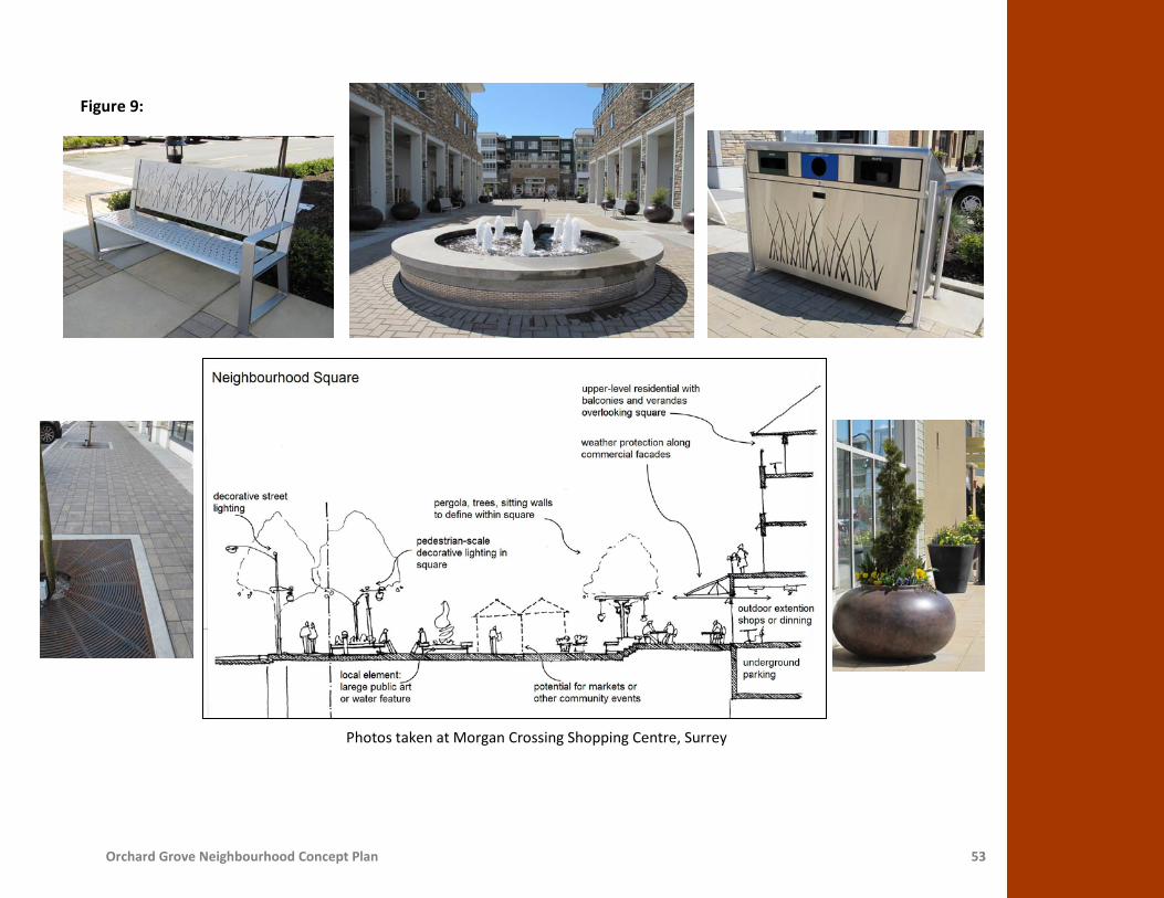
Neighbourhood Square A neighbourhood square is planned as part of the mixed use, residential and commercial designation at the corner of 168 Street and 24 Avenue. This square will face onto the Special Commercial Street. The objective of this square is to provide a combination of activities and spaces that give residents a vibrant and attractive place to come together. Important considerations for this square include elements such as access and connection to surrounding streets, public seating and a strong image and identity (Figure 9). Design Guidelines for the development of a Neighbourhood Square: • The square should include a central open space
appropriate for accommodating neighbourhood events and gatherings, along with smaller, more intimate areas defined through the use of canopies, trees, and trellises.
• A strong feature, such as a fountain should be included as a focal point in the square. This feature will provide the square with a strong image and identity.
• Outdoor extensions of cafes and restaurants into the square are encouraged.
• Commercial developments along the edges of the
square shall provide public seating. The public seating may be provided in multiple forms such as benches, sit-walls, ledges and steps.
• Provide a coordinated group of furnishings (bike racks, signs, benches and waste receptacles) to match the overall character of the development.
• The surface of the square shall have pavement with contrasting colours and textures for visual interest. Permeable and porous pavement is recommended.
• Commercial and directional signage should be
oriented to pedestrians and relate to the scale and character of the neighbourhood commercial area. Way finding signs should be installed.
• The square should be barrier free and allow multi-modal access.
• The Special Commercial Street adjacent to the square should include traffic-calming measures such as planted curb extensions, traffic buttons, parallel parking pockets and sidewalks. The intersection design should include contrasting colour and textured pavement for pedestrian crosswalks.
• Large surface parking lots are not permitted in the
square. Short-term may be considered.
Orchard Grove Neighbourhood Concept Plan 53
Figure 9:
Photos taken at Morgan Crossing Shopping Centre, Surrey
Orchard Grove Neighbourhood Concept Plan 54
On-Site Stormwater Controls On-site stormwater controls are required for all developments in the Orchard Grove NCP. Relying heavily on sustainable, landscaped-based stormwater source controls, the intent is to maximize infiltration and evapo-transpiration of rainwater. Mixed use, commercial and residential developments are required to meet performance targets for on-site stormwater source controls. The recommended source control measures include:
• 300mm layer of enhanced or amended topsoil placed on all pervious areas of the site; • Absorbent landscaping that promotes the capture and retention of stormwater; • Infiltration galleries to provide a retention volume of 250 m3/ha of impervious area; and • Disconnected roof leaders that direct roof runoff to splash pads.
The specific mix of source control methods is up to each site owner to allow for integration into the site’s overall architectural and landscaping concept. Layout, configuration, and construction of these additional controls should be done in accordance with the City of Surrey’s Best Management Practices (BMPs). The Engineer of Record is to verify in writing that all BMPs have been designed in accordance with the Guidelines and properly installed.

Orchard Grove Neighbourhood Concept Plan 55
Summary of Requirements for Development in the Mixed Use, Commercial and Residential Designation:
Mixed Use, Commercial and Residential
Maximum Net Density 30 to 45 upa 0.9 to 1.5 Floor Area Ratio (FAR) and the residential component does not exceed
67% of the total floor area
Form of Development Mixed use, with commercial and office space at the ground level or second floor and residential units above, up to a maximum six stories high with underground
parking.
Maximum Lot Coverage 45 to 80%
Lane Access Not required. Access required from Special Commercial Street. No vehicular access is permitted from a collector or an arterial road.
Coach House Not permitted.
Development Permit Required and subject to the design requirements noted above in this section.
Minimum Land Assembly Required. Refer to Land Consolidation Areas section of this document for more information.
Interface Conditions For developments adjacent to the Multi-Use Trail on 24 Avenue, design criteria are outlined in the Multi-Family section of this document.
For developments adjacent to the Special Commercial Street, additional design
criteria are outlined in the Special Streetscapes section of this document.

Orchard Grove Neighbourhood Concept Plan 56
Parks and Open Space - Land Use & Design Guidelines
A network of parks and open spaces throughout the NCP area is proposed to provide active and passive recreational opportunities for residents and to facilitate habitat connectivity and tree preservation (Figure 10). The proposed parks build on the existing foundation of City and community level open space provided or planned in the Grandview Heights area. These parks are proposed to be linked through amenity connectors.
The amount of parkland in the NCP has been determined by following the guidelines of the Parks, Recreation and Culture Strategic Plan requiring 1.2 hectares (3 acres) of active and passive neighbourhood parkland per 1000 people. Based on an estimated build out population of between 1,600 and 2,900 people in this NCP, a total of 2.5 hectares (6.2 acres) of parkland is provided in two parks. The Community and City level parks as described in the Strategic Plan are planned to be in the immediate area of Orchard Grove and are therefore not required in this NCP area. Surrey’s Parks, Recreation and Culture Department will manage and oversee the construction and maintenance of public parks. The Green Street running between the two park sites will be designed and built to maximize tree preservation and habitat connectivity, while minimizing disruption to the natural ecosystem, prior, during and after construction. The NCP area will be connected to the greater Grandview Heights community through wider sidewalks, signage and a Multi-Use Trail on 24 Avenue.

Orchard Grove Neighbourhood Concept Plan 57
Figure 10:

Orchard Grove Neighbourhood Concept Plan 58
Active Neigbhourhood Park Orchard Grove NCP contains a 1.5 hectare (3.8 acre) active neighbourhood park within approximately 400 metre (1,300 feet) walking distance of all residents in this neighbourhood. The active park will contain informal playing fields, playgrounds, walking trails and other active amenities, as well as enhanced natural areas to promote habitat connectivity and to allow for tree preservation. This kind of park could have amenities such as integrated and compact youth and early child play areas, a walking track around the park perimeter and community gardens. The park amenities will be determined based on community consultation at time of development. Crime Prevention Through Environmental Design (CPTED) will be considered in the design of the park. The park will be designed to be accessible for all residents of Surrey regardless of age or ability. The tree plantings and community garden will be designed to reflect the history and character of the area as an Orchard Grove. Community consultation and collaboration with the future residents of this Neigbhourhood will help guide the development to foster ownership of the park and its amenities.
Photos taken at Hawthorn Place, UBC, Vancouver

Orchard Grove Neighbourhood Concept Plan 59
Passive Park An one hectare (2.5 acre) passive park protecting stands of high value Douglas Fir trees is planned for Orchard Grove NCP. The emphasis of this park is natural area connectivity protecting valuable trees and preserving habitat for wildlife. The park will contain natural area trails connecting the active neighbourhood park to the West and the mixed use, commercial and residential area to the East. The trails will be designed to connect the community and visitors to and through the neighbourhood while allowing opportunities for: interpretive education, maximizing tree preservation and ensuring safety and accessibility.
Trees on 167 Street (Photos taken at Orchard Grove)

Orchard Grove Neighbourhood Concept Plan 60
Stormwater Detention Pond- Land Use & Design Guidelines
An one hectare (2.5 acre) stormwater detention pond is required to service the drainage needs of the Orchard Grove NCP. It is located at the corner of 26 Avenue and 164 Street, a gateway to the community. As part of the Engineering design and construction process, the stormwater detention pond will be designed to function as a community amenity with the following features: a viewing platform, a perimeter walking trail, and trees and landscaping (Figure 11).
Photos taken at Southmere Village Park and Morgan Heights Linear Park, Surrey
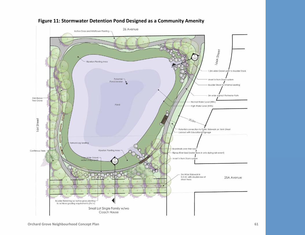
Orchard Grove Neighbourhood Concept Plan 61
Figure 11: Stormwater Detention Pond Designed as a Community Amenity

Orchard Grove Neighbourhood Concept Plan 62
Special Streetscapes
Orchard Grove will be a highly walkable and interconnected community with a fine grid street network, wider sidewalks (amenity connectors) and off street walkways. The street network provides increased options to disperse traffic and avoid congestion. On average, block sizes are approximately 100 metres (328 feet) by 200 metres (656 feet). These block sizes promote walkability since pedestrians are able to avoid circuitous routes and reach destinations more directly. Special Streets have been introduced into the plan to provide connectivity while responding to site-specific challenges. These local streets provide flexibility in the alignment and cross-section so that public connections through the sites are possible. The Special Streets include:
• A Special Commercial Street from 167A Street to 24A
Avenue with a road right-of-way changing between 14.5 metres (48 feet) and 16.5 metres (54 feet) including a sidewalk, parallel parking pockets, curb extensions and special pavement treatment. The intent of the Special Commercial Street is to ensure pedestrian safety and to provide on-street parking opportunities while allowing for vehicular access to the mixed use, commercial and residential area (Figure 12).
• A Residential Flex Street on 24A Avenue with a road
right-of-way of 14.5 metres (48 feet). The alignment of 24A Avenue is flexible between 164 Street and 166 Street provided that appropriate intersection spacing is maintained and the alignment follows the established pattern in the NCP.
Figure 12: Special Commercial Street
14.5m
14.5m 16.5m

Orchard Grove Neighbourhood Concept Plan 63
• A Green Street on 167 Street to protect existing mature Douglas Fir trees. The cross section, alignment, design and construction of 167 Street will need to ensure that there is maximum tree preservation and minimum disruption to the natural environment.
In addition to the Special Streets, Amenity Connectors are enhanced 2.5 metre (8 feet) wide sidewalks, and have been located throughout the neighbourhood. They have been placed where higher numbers of pedestrians are anticipated– adjacent to parks and through the central axes of the neighbourhood. The amenity connectors will require statutory right-of-way on adjacent lands.

Orchard Grove Neighbourhood Concept Plan 64
Land Consolidation Areas
Within the plan area there are a number of smaller acreage parcels and irregularly shaped lots. In several areas, lot consolidation areas have been identified to ensure:
• Development that results in the most efficient and feasible development of these properties. • Dedication of strategic road connections that support and ensure that plan objectives are realized. • Construction of offsite works and services and associated costs are distributed more equitably.
Pre-determined consolidation requirements are identified in this NCP as shown in Figure 13, Land Assembly Area Map, and additional consolidation opportunities may be determined on a case-by-case basis at the development application stage. These consolidation areas will avoid leaving remnant pieces that may be difficult to develop on their own, or that have significant portions of planned City infrastructure. Where challenges occur to secure the land assembly required, the onus will be on the applicant to:
• Demonstrate that reasonable efforts have been made to secure the lands identified in the Land Assembly Map.
• Prepare a development concept plan, to the satisfaction of the City Engineer and the Approving Officer, for the remaining properties in the absence of the identified land assembly, thus confirming that the remaining properties are not unduly isolated.
• Provide funding for the equitable distribution of road construction and land costs for roads fronting the identified land assembly area. The applicant’s Engineer will need to submit a preliminary design and cost estimate for the construction of all perimeter roads. These costs will be shared between the properties in a land assembly area based on the probable unit yield for each property.

Orchard Grove Neighbourhood Concept Plan 65
• yield for each property.
Figure 13:

Orchard Grove Neighbourhood Concept Plan 66
Population & Dwelling Unit Projections
The expected population of the Orchard Grove NCP, based on the Land Use Concept at full build-out, will be approximately 1,600 to 2,900 people in 700 to 1,200 dwelling units.
Breakdown of Dwelling Units and Population Projections:
Proposed Land Use Area
(Acres)
Total Number of Dwelling Units
Population Projections
Minimum Maximum Minimum Maximum
Large Lot Duplex or Large Lot Single Family (2-10 upa) 4.0 8 40 24 120
Small Lot Single Family w/wo Coach House (10-15 upa) 11.2 112 168 336 504
Single Family (10 upa) or Townhouse with Tree Preservation (15 upa)
2.4 24 36 72 108
Townhouse (15-30 upa) 14.7 221 441 553 1103
Townhouse (15 upa) or Multi-Family with Tree Preservation (30 upa)
2.9 44 87 110 218
Multi-Family (30-45 upa) 7.4 222 333 444 666
Mixed Use, Commercial & Residential (30-45 upa) 1.9 57 86 114 172
Total 44.5 688 1,191 1,653 2,891

Orchard Grove Neighbourhood Concept Plan 67
Community Services and Amenities
To address the amenity needs of the proposed new development in Orchard Grove, all development proposals at the time of rezoning or building permit issuance will be required to make a monetary contribution toward the provision of new police, fire protection and library services and toward the development of the parks, open spaces and pathways. The monetary contributions toward police, fire and library materials will offset the capital costs of providing these services to the new development and are applied on a standardized basis in all of Surrey's Neighbourhood Concept Plan areas. The monetary contributions toward parks, open spaces and pathway development are based upon an estimate of the capital costs of these improvements for this particular NCP area. All the monetary contribution amounts noted below are in 2011 dollars. Parkland Development The Orchard Grove community will contain two park areas. A major public art feature will be constructed within the traffic circle and a gateway feature will be constructed at 26 Avenue and 164 Street within the stormwater pond facility. The remaining entrance features will be constructed through private development. The estimated cost of developing park and related amenities in the Orchard Grove NCP is approximately $769,923.83. This results in a contribution of $1,099.89 per dwelling unit. Library and Library Material A study of library requirements in Surrey's new neighbourhoods has established that a contribution of $137.98 per dwelling unit (non-residential development is exempt) is necessary to cover the capital costs for library materials and services, which is sensitive to population growth. Consequently, a total of approximately $96,586.00 will be collected from Orchard Grove towards materials such as books, computers and CDs. Fire and Police Protection Future development in this neighbourhood will drive the need to upgrade existing fire and police protection facilities. A study of fire protection requirements in Surrey's new neighbourhoods has established that a contribution of $264.92 per

Orchard Grove Neighbourhood Concept Plan 68
dwelling unit and $1,059.70 per acre of non-residential development will cover the capital costs for fire protection. A contribution of $61.33 per dwelling unit and $245.26 per acre of non-residential development will cover the capital costs for police protection. This will result in a total capital contribution from Orchard Grove of approximately $187,457.43 toward fire protection and $43,396.99 toward police protection. Summary of Amenity Funding Arrangements A summary of the applicable amenity contributions (per dwelling unit or per acre) and the estimated revenue the City can expect to receive from the Orchard Grove NCP area is documented in the following table.
Per Unit Contribution for All Residential Dwelling Units
(in 2011 dollars)
Per Acre Contribution for All Non-Residential Uses
(in 2011 dollars)
Anticipated Revenue based on 700 dwelling units
and 1.9 acres non-residential Police Protection $61.33 per dwelling $245.26 per acre $43,396.99
Fire Protection $264.92 per dwelling $1,059.70 per acre $187,457.43 Development of
Park/Pathways and Placemaking Features
$1,099.89 per dwelling N/A $769,923.00
Library Materials $137.98 per dwelling N/A $96,586.00 Total Contribution $1,564.12 per dwelling $1,304.96 per acre
Total Anticipated Revenue $1,094,884.00 $2,479.42 $1,097,363.40 The above-noted per unit amenity contributions are derived from estimated base densities in the residential designations and the number of dwelling units (excluding any coach houses and secondary suites) anticipated. The estimated costs of the various amenities are distributed evenly to each dwelling unit. Therefore, if the number of dwelling units in a proposed development is lower than that anticipated by the NCP, the applicant will be expected to "top up" the amenity fees based on the number of the dwelling units used to calculate the amenity charge to ensure that there is no shortfall in the funding for the proposed amenities.

Orchard Grove Neighbourhood Concept Plan 69
Implementation Procedures
The following section outlines the implementation procedures for developments within the Orchard Grove NCP. OCP Amendments The entire area covered by the Orchard Grove NCP is currently designated Suburban in the OCP. Although the NCP Land Use Plan anticipates changes to the OCP designations in Orchard Grove, the determination of the precise boundaries of these changes cannot be established until a detailed survey plan is presented. It is, therefore, recommended that any necessary changes to the OCP designations in the Orchard Grove area proceed concurrently with site specific rezoning applications as has been the City’s normal practice. Rezoning The residential lands will need to be rezoned before development can proceed. Areas suitable for development will be rezoned when owners make application consistent with this plan. Subdivision Future subdivision will be consistent with both the NCP and the ultimate zoning. Detailed subdivision patterns will be determined at the subdivision application stage. Development Permit Area Guidelines All multiple residential developments will be reviewed in accordance with the Development Permit Guidelines of the Official Community Plan and the requirements of this NCP. Design Guidelines The NCP contains design guidelines for land uses that are intended to provide direction to achieve the desired neighbourhood character, preserve and enhance natural space, encourage pedestrian access to destination areas, and achieve the overall development objectives defined in the NCP.

Orchard Grove Neighbourhood Concept Plan 70
These guidelines will be used by City staff to guide and coordinate the design among individual development applications and to ensure that the desired neighbourhood character is achieved in Orchard Grove. The Design Guidelines will be implemented through Building Schemes for single family developments, which will be registered on the lots and administered by design consultants hired by the applicant for each development site and approved by the City. For all other types of development, the Design Guidelines will be implemented through Development Permits. Amenity Contributions Surrey’s policy is that NCPs address funding arrangements for the provision of community facilities, amenities, and services (such as park development, police, fire, and library materials) that are translated into specific contribution requirements and adopted by Council in the Zoning Bylaw. The amenity contribution is payable upon subdivision for single family subdivisions or upon issuance of building permits for other types of development. The bylaw provides that the base rates for amenity contributions are adjusted annually on March 1 based on Vancouver’s annual average consumer price index (CPI) for the preceding year. Zoning By-law Amendment To enact the amenity contribution requirements, the Zoning By-law requires an amendment to add Orchard Grove to the list of NCPs within which monetary contributions are required. NCP Amendments Any proposed major or minor amendments to this Neighbourhood Concept Plan must be undertaken in accordance with Council’s approved NCP amendment policy contained Surrey’s Official Community Plan (OCP).


