13091$ 5-21-13 I ORDINANCE NO. 7LJ I An ordinance amending Article 759, “PD 759,” of Chapter 51P, “Dallas Development Code: Planned Development District Regulations,” of the Dallas City Code; adding a new Section 51P- 759.103.1; amending the definitions and interpretations, main uses permitted, yard, lot, and space, design standards, and landscaping regulations in Sections 51P-759.103, 51P-759.106, 51P-759.108, 51P-759.109. and 51P-759.l 13 of Article 759; deleting the zoning map regulations in Section 51P-759.117; providing a new property description; providing a new conceptual plan; providing a penalty not to exceed $2,000; providing a saving clause; providing a severability clause; and providing an effective date. WHEREAS, the city plan commission and the city council, in accordance with the Charter of the City of Dallas, the state law, and the ordinances of the City of Dallas, have given the required notices and have held the required public hearings regarding this amendment to thc Dallas City Code; and WHEREAS. the city council finds that it is in the public interest to amend Article 759 as specified in this ordinance; Now, Therefore. BE IT ORDAIXED BY THE CITY COFOiCIL OF THE CITY OF DAT LAS:
Transcript
13091$5-21-13
IORDINANCE NO. 7LJ I
An ordinance amending Article 759, “PD 759,” of Chapter 51P, “Dallas Development Code:
Planned Development District Regulations,” of the Dallas City Code; adding a new Section 51P-
759.103.1; amending the definitions and interpretations, main uses permitted, yard, lot, and
space, design standards, and landscaping regulations in Sections 51P-759.103, 51P-759.106,
51P-759.108, 51P-759.109. and 51P-759.l 13 of Article 759; deleting the zoning map regulations
in Section 51P-759.117; providing a new property description; providing a new conceptual plan;
providing a penalty not to exceed $2,000; providing a saving clause; providing a severability
clause; and providing an effective date.
WHEREAS, the city plan commission and the city council, in accordance with the
Charter of the City of Dallas, the state law, and the ordinances of the City of Dallas, have given
the required notices and have held the required public hearings regarding this amendment to thc
Dallas City Code; and
WHEREAS. the city council finds that it is in the public interest to amend Article 759 as
specified in this ordinance; Now, Therefore.
BE IT ORDAIXED BY THE CITY COFOiCIL OF THE CITY OF DAT LAS:
29021130918
SECTION 1. That Section 51P-759.103, “Definitions and Interpretations,” of Article
759, “PD 759,” of Chapter 51P, “Dallas Development Code: Planned Development District
Regulations,” of the Dallas City Code is amended to read as follows:
“SEC. 51P-759J03. DEFINITIONS AND INTERPRETATIONS.
(a) Unless otherwise stated, the definitions and interpretations in Chapter 51 A applyto this article. In this article: [district,]
LU SHOPPING CENTER SIGN means a sign that identifies several owners,tenants, or occupants within the district.
(b) Unless otherwise stated, all references to articles, divisions, or sections in thisarticle are to articles, divisions, or sections in Chapter 51 A.
(c) This district is divided into three Subdistricts: Subdistrict I, Subdistrict Il-A, andSubdistrict TI-B.
4) This district is considered to be a nonresidential zoning district.”
SECTION 2. That Article 759, “PD 759,” of Chapter 5lP, “Dallas Development Code:
Planned Development District Regulations,” of the Dallas City Code is amended by adding a
new Section 5lP-759.l03.l. “Exhibit,” to read as follows:
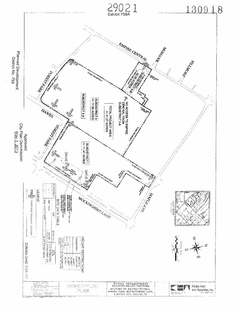
“SEC. 51P-759J03.1. EXHIBIT.
The following exhjit is incorporated into this article: Exhibit 759A: conceptual plan.”
- 1309189Q1
SECTION 3. That Section 51P-759.106, “Main Uses Permitted,” of Article 759, “PD
759,” of Chapter 51P, “Dallas Development Code: Planned Development District Regulations.”
of the Dallas City Code is amended to read as follows:
“SEC. 51P-759.106. MAIN USES PERMITTED.
Except as provided in this section, t[T]he only main uses permitted in this districtare those main uses permitted in the RR Regional Retail District, subject to the same conditionsapplicable in the RR Regional Retail District, as set out in Chapter 51 A. For example, a usepermitted in the RR Regional Retail District only by specific use permit (SUP) is permitted inthis district only by SUP; a use subject to development impact review (DIR) in the RR RegionalRetail District is subject to DIR in this district, etc.
Q) Multifamily uses are permitted by right in Subdistrict Il-A and Subdistrict Il-B.”
SECTION 4. That Section 51P-759.108, “Yard, Lot, and Space Regulations,” of Article
759, “PD 759,” of Chapter 51P, “Dallas Development Code: Planned Development District
Regulations,” of the Dallas City Code is amended to read as follows:
“SEC. 51P-759.108. YARD, LOT, AND SPACE REGULATIONS.
(Note: The yard. lot, and space regulations in this section must be read together with theyard, lot, and space regulations in Division 51A-4.400. If there is a conflict between this sectionand Division 5 IA- 4.400, this section controls.)
(a) ral.
jj Subdistrict 1. Except as provided in this section, the yard, lot, and spaceregulations for the RR Regional Retail District apply.
J Subdistnct H-A and_Subdistrict Ii Excent asm ed in this sectn.the yard, lot, and space regulations for the MF3( A) Multifamily District apply.
(b) Front yard. Minimum front yard is 15 feet at the boundaries of this district, asshown on the conceptual plan. Otherwise, no front yard setback is required.
(c) Side and rear yard. Minimum side and rear yard is 15 feet at the boundaries ofthis district. Otherwise, no side and rear yard setback is required.
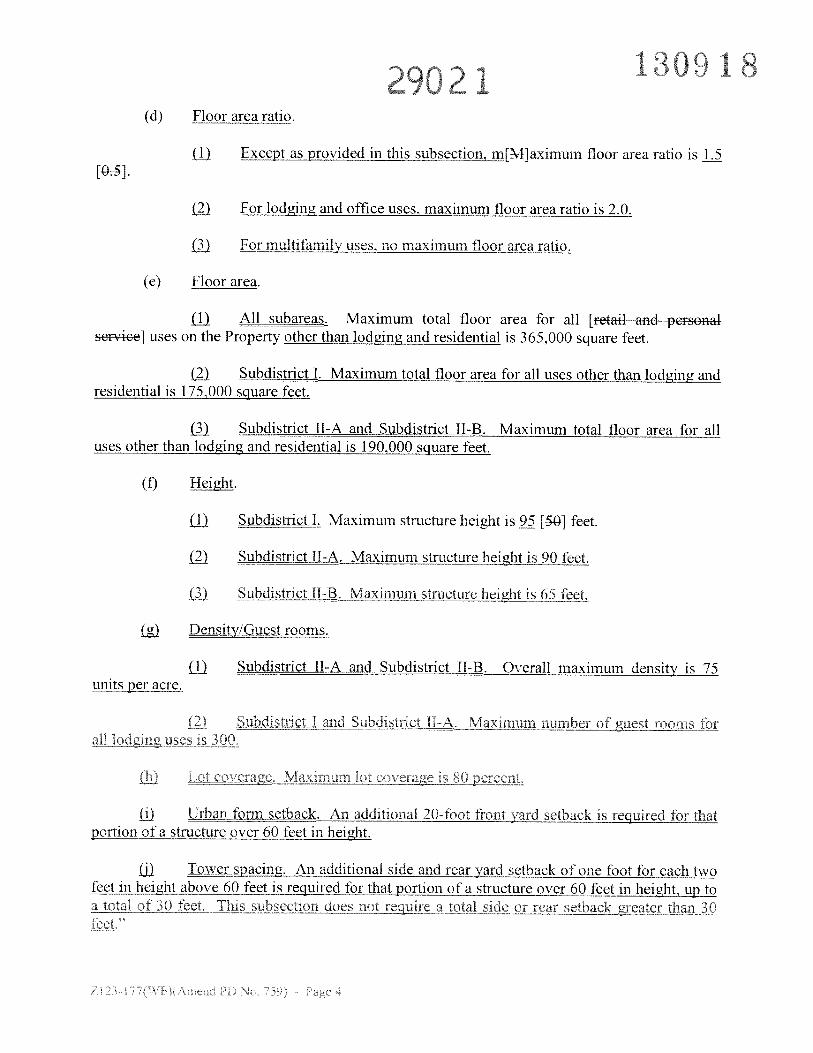
29021(d) Floor area ratio.
j) Except as provided in this subsection, m[M]aximum floor area ratio is 1.5[Os].
( For lodging and office uses, maximum floor area ratio is 2.0.
) For multifamily uses, no maximum floor area ratio.
(e) Floor area.
LU All subareas. Maximum total floor area for all [retail and personalservice] uses on the Property other than lodging and residential is 365,000 square feet.
) Subdistrict!. Maximum total floor area for all uses other than lodging andresidential is 175,000 square feet.
Subdistrict IT-A and Subdistrict TI-B. Maximum total floor area for alluses other than lodging and residential is 190,000 square feet.
(f) Height.
LU Subdistrict I. Maximum structure height is 95 [&O] feet.
) Subdistrict II A. Maximum structure height is 90 feet.
Subdistrict lI-B, Maximum structure height is 65 feet.
t’/Guestroprns.
LU Subdistrict 11-A and Subdistrict Il-B. Overall .maxj mdensit is 75units per acre.
( Subdistrict I and Subdistrict Il-A Maximum number of guest_rooms forall lo4gng uses is 300
U M xi irum 1 t co s pç
ti) Urban form setback, An additional 20-foot front yard etbaJ requird for thatportion of a structure over 60 feet in height.
j) Tawer spacing. An additional side and rear yard setback of one foot for each twofeet icjg3t above 60 fcfjs re uirçd f rtiftmrv’60 feet jict2a total of 30 feet fins subsection does not rçqre a total side or rear setback greater than 30
101829021
SECTION 5. That Section 51P-759.109, “Design Standards,” of Article 759, “PD 759,”
of Chapter 51 P. “Dallas Development Code: Planned Development District Regulations,” of the
Dallas City Code is amended to read as follows:
“SEC. 51P459.109. DESIGN STANDARDS.
(a) Except as provided in this section, the design standards and procedures in Section5lA-4605 apply to any retail uses, personal service uses, or combination thereof, totalling75,000 square feet or more of floor area and located within the same structure.
(b) Trees planted in planters count toward the tree planting requirements in Section51 A-4.605(a)(8)(F).
(c) The city plan commission, whether or not a specific use permit is required, mayapprove a site plan that does not comply with the requirements of the design standards providedthat:
(1) strict compliance with the design standards is impractical due to siteconstraints or would result in substantial hardship;
(2) the site plan complies with the spirit and intent of the design standards;
(3) the site plan furthers the stated purpose of the design standards; and
(4) the variation or exception from the design standards will not adverselyaffect surrounding properties.
For amendments to the design standards sitqpfuj[T]he city plan commission shall follow thesame procedures used for approval of minor amendments to development plans, and the fee for aminor plan amendment shall apply”
29021 130918SECTION 6. That Subsection (c), “Alternative Tree Mitigation,” of Section 51P-
759.113, “Landscaping,” of Article 759, “PD 759,” of Chapter 51P, “Dallas Development Code:
Planned Development District Regulations,” of the Dallas City Code is amended to read as
follows:
“(c) Alternative tree mitigation.
(1) [The building official shall allow an inch for inch tree mitigation credit forhealthy, growing trees located in the permanently reserved, publicly accessible open spaceshown on the conceptual plan.
-)j The building official shall allow an inch-for-inch tree mitigation credit forhealthy, growing, protected trees with a caliper of six inches or more that are transplanted intoparking lot islands or medians on the Property.
(2[3]) The building official shall evaluate the condition of trees used foralternative tree mitigation during the first landscape inspection on the Property.”
SECTION 7. That Section 51P-759.117, “Zoning Map,” of Article 759, “PD 759,” of
Chapter 5lP, “Dallas Development Code: Planned Development District Regulations,” of the
Dallas City Code s deleted as tollows:
“[SEC. 1P 759.117. ZONINC MAP.
SECTION 8. That the property description. Exhibit A. attached to Ordinance No. 26871
is replaced by the Exhibit A attached to this ordinance.
SECTION 9. That the conceptual plan, Exhibit 759A of Article 759, “PD 759,” of
Chapter 51P of the Dallas City Code, is replaced by the Exhibit 759A attached to this ordinance.
SECTION 10. That development of this district must comply with the full-scale version
of Exhibit 759A (conceptual plan) attached to this ordinance. A reducedsized version of this
130918Iplan shall be provided in Chapter 51P. Permits shall he issued based on information provided on
the full-scale version of the plan.
SECTION 11. That a person who violates a provision of this ordinance, upon conviction,
is punishable by a fine not to exceed S2.000.
SECTION 12. That Chapter 5lP of the Dallas City Code, as amended. shall remain in
full force and effect, save and except as amended by this ordinance.
SECTION 13. That the terms and provisions of this ordinance are severable and are
governed by Section 1-4 of Chapter 1 of the Dallas City Code, as amended.
SECTION 14. That this ordinance shall take effect immediately from and after its
passage and publication, in accordance with the Charter of the City of Dallas, and it is
accordingly so ordained.
APPROVED AS TO FORM:
THOMAS P. PERKINS, JR., City Attorney
By
MAy2220I3rasseu
29021 130918Exhthit A
G IS_Approved
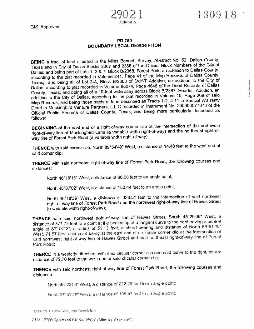
PD 759BOUNDARY LEGAL DESCRIPTION
BEING a tract of land situated in the Miles Bennett Survey, Abstract No. 52, Dallas County,
Texas and in City of Dallas Blocks 2367 and 2368 of the Official Block Numbers of the City of
Dallas; and being part of Lots 1, 2 & 7, Block 8/2368, Forest Park, an addition to Dallas County,
according to the plat recorded in Volume 241, Page 41 of the Map Records of Dallas County,
Texas; and being all of Lot 2-A, Block 8/2368 of Swif-T Addition, an addition to the City of
Dallas, according to plat recorded in Volume 85074, Page 4646 of the Deed Records of Dallas
County, Texas; and being all of a 10-foot wide alley across Block B/2367, Heartsill Addition, an
addition to the City of Dallas, according to the plat recorded in Volume 10, Page 269 of said
Map Records; and being those tracts of land described as Tracts 1-2, 4-11 in Special Warranty
Deed to Mockingbird Venture Partners, L.L.C recorded in Instrument No. 200900077070 of the
Official Public Records of Dallas County, Texas; and being more particularly described as
follows:
BEGINNING at the east end of a right-of-way corner clip at the intersection of the northwest
right-of-way line of Mockingbird Lane (a variable width right-of-way) and the northeast right-of-
way line of Forest Park Road (a variable width right-of-way);
THENCE with said corner clip, North 89°54’49” West, a distance of 14.48 feet to the west end of
said corner clip;
THENCE with said northeast right-of-way line of Forest Park Road, the following courses and
distances:
North 46°16’18” West, a distance of 96.08 feet to an angle point;
North 46°07’02” West, a distance of 150.44 feet to an angle point;
North 46°18’39” West, a distance of 329.51 feet to the intersection of said northeast
right-of-way line of Forest Park Road and the northwest right-of-way line of Hawes Street
(a variable width right-of-way);
THENCE with said northwest right-of-way line of Hawes Street, South 45°29’09” West, a
distance of 37172 feet to a point at the beginning of a tangent curve to the right having a central
angle of 89°18’13”, a radius of 51.13 feet, a chord bearing and distance of North 89°51’45”
West, 71.87 feet; said point being at the east end of a circular corner clip at the intersection of
said northwest right-of-way line of Hawes Street and said northeast right-of-way line of Forest
Park Road;
THENCE in a westerly direction, with said circular corner clip and said curve to the right, an arc
distance of 79.70 feet to the west end of said circular corner dip;
THENCE with said northeast right-of-way line of Forest Park Road, the following courses and
distances:
North 452353” West, a distance of 22229 feet to an angle point;
North 375228 West, a distance of 19547 feet to an anale point:
Z 123-177(WE)(Arnend PD No, 759>(Exhlbit Aj Page I of
29021-
Exhibit A 1 3 () 9 1 8G IS_Approved
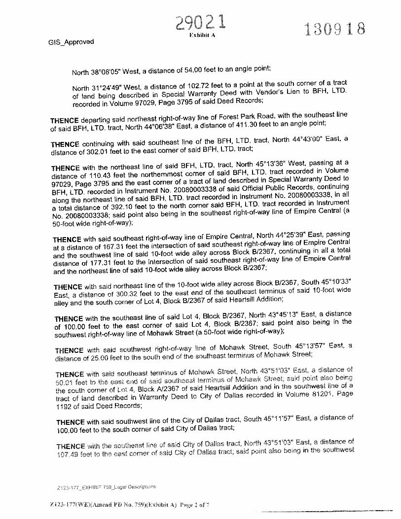
North 38°08’05” West, a distance of 54.00 feet to an angle point;
North 31 024t49 West, a distance of 102.72 feet to a point at the south corner of a tract
of land being described in Special Warranty Deed with Vendor’s Lien to BFH, LTD.
recorded in Volume 97029, Page 3795 of said Deed Records;
THENCE departing said northeast right-of-way tine of Forest Park Road, with the southeast line
of said BFH, LTD. tract, North 44°06’38” East, a distance of 411.30 feet to an angle point;
THENCE continuing with said southeast line of the BFH, LTD. tract, North 4443’00” East, a
distance of 302.01 feet to the east corner of said BFH, LTD. tract;
THENCE with the northeast line of said BFH, LTD. tract, North 45°13’36” West, passing at a
distance of 110.43 feet the northernmost corner of said BFH, LTD. tract recorded in Volume
97029, Page 3795 and the east corner of a tract of land described in Special Warranty Deed to
BFH, LTD. recorded in Instrument No. 20080003338 of said Official Public Records, continuing
along the northeast line of said BFH, LTD. tract recorded in Instrument No. 20080003338, in all
a total distance of 39210 feet to the north corner said BFH, LTD. tract recorded in Instrument
No. 20080003338; said point also being in the southeast right-of-way line of Empire Central (a
50-foot wide right-of-way);
THENCE with said southeast right-of-way line of Empire Central, North 44°25’39” East, passing
at a distance of 167.31 feet the intersection of said southeast right-of-way line of Empire Central
and the southwest line of said 10-foot wide alley across Block B/2367, continuing in all a total
distance of 177.31 feet to the intersection of said southeast right-of-way line of Empire Central
and the northeast line of said 10-foot wide alley across Block 8/2367;
THENCE with said northeast line of the 10-foot wide alley across Block 8/2367, South 45°i0’33”
East, a distance of 300.32 feet to the east end of the southeast terminus of said 10-foot wide
alley and the south corner of Lot 4, Block 8/2367 of said Heartsill Addition;
THENCE with the southeast line of said Lot 4, Block 8/2367, North 43°4513” East, a distance
of 100.00 feet to the east corner of said Lot 4, Block B/2367; said point also being in the
southwest right-of-way line of Mohawk Street (a 50-foot wide right-of-way):
THENCE with said southwest right-of-way line of Mohawk Street, South 45°13’57” East, a
distance of 25.00 feet to the south end of the southeast terminus of Mohawk Street:
THENCE with said southeast terminus of Mohawk Street, North 435103” East. a distance of
50.01 feet to the east end of said southeast terminus of Mohawk Street; said point also being
the south corner of Lot 4, Block A12367 of said Heartsibl Addition and in the southwest Hne of a
tract of land described in Warranty Deed to City of Dallas recorded in Volume 81201, Page
1192 of said Deed Records;
THENCE with said southwest line of the City of Dallas tract, South 451 1’57” East, a distance of
100.00 feet to the south corner of said City of Dallas tract;
THENCE with the southeast line of said City of Dallas tract, North 435i’03” East, a distance of
107.49 feet to the east corner of said City of Dallas tract; said point also being in the southwest
ZI23-I77(WE)(:4.jp P1) No, 759)(ExhIbitA) Page 2 of 7
a9021 1O18Exhibit AGIS_Approved
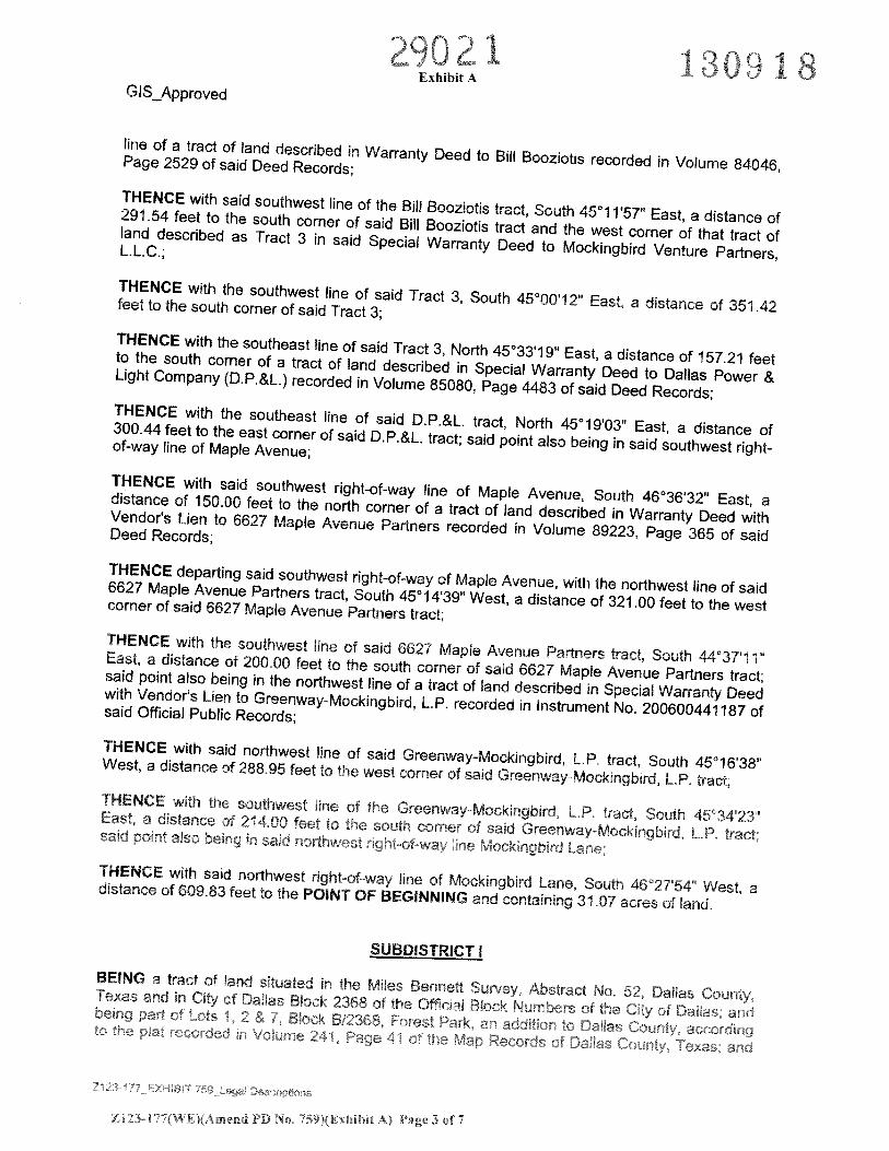
line of a tract of land described in Warranty Deed to Bill Booziotis recorded in Volume 84046,Page 2529 of said Deed Records;
THENCE with said southwest line of the Bill Booziotis tract, South 45°11’57” East, a distance of291.54 feet to the south corner of said Bill Booziotis tract and the west corner of that tract ofland described as Tract 3 in said Special Warranty Deed to Mockingbird Venture Partners,L.L.C.;
THENCE with the southwest line of said Tract 3, South 45°00’l 2” East, a distance of 351.42feet to the south corner of said Tract 3;
THENCE with the southeast line of said Tract 3, North 45°33’19” East, a distance of 157.21 feetto the south corner of a tract of land described in Special Warranty Deed to Dallas Power &Light Company (D.P.&L.) recorded in Volume 85080, Page 4483 of said Deed Records;THENCE with the southeast line of said D.P.&L. tract, North 45°19’03” East, a distance of300.44 feet to the east corner of said D.P.&L. tract; said point also being in said southwest right-of-way line of Maple Avenue;
THENCE with said southwest right-of-way line of Maple Avenue, South 46°36’32” East, adistance of 150.00 feet to the north corner of a tract of land described in Warranty Deed withVendor’s Lien to 6627 Maple Avenue Partners recorded in Volume 89223, Page 365 of saidDeed Records;
THENCE departing said southwest right-of-way of Maple Avenue, with the northwest line of said6627 Maple Avenue Partners tract, South 45°14’39” West, a distance of 321.00 feet to the westcorner of said 6627 Maple Avenue Partners tract:
THENCE with the southwest line of said 6627 Maple Avenue Partners tract, South 44°37’l 1”East, a distance of 200.00 feet to the south corner of said 6627 Maple Avenue Partners tract;said point also being in the northwest line of a tract of land described in Special Warranty Deedwith Vendor’s Lien to Greenway-Mockingbird, L.P. recorded in Instrument No. 200600441187 ofsaid Official Public Records;
THENCE with said northwest line of said Greenway-Mockingbird, L.P. tract, South 45°16’38”West, a distance of 288.95 feet to the west corner of said Greenway-Mockingbird, L.P. tract;THENCE with the southwest line of the Greenway-Mockingbird, LP. tract, South 45t3423East a distance of 214 00 feet to th sotb corner of sad Greenway-Mockngbrd L P tractsaid point also being in said northwest right-of-way line Mockingbird Lane;THENCE with said northwest right-of-way line of Mockingbird Lane, South 46°2T54” West, adistance of 60983 feet to the POINT OF BEGINNING and containing 31.07 acres of land.
SUBDISTRICT I
BEING a tract of land situated in the Miles Bennett Survey, Abstract No, 52, Dallas County,Texas and in City of Dallas Block 2368 of the Official Block Numbers of the City of Dallas; andeeirg Dart ef Lois 2 & 7 Boc B!368 Forest Park ar addwon to Dallas Coun” sr’ord rto the let recorded in V’jftrne 241 Page 41 of the Map Records of Dallas County, Texas.; and
29021Exhibit A
GIS_Approved
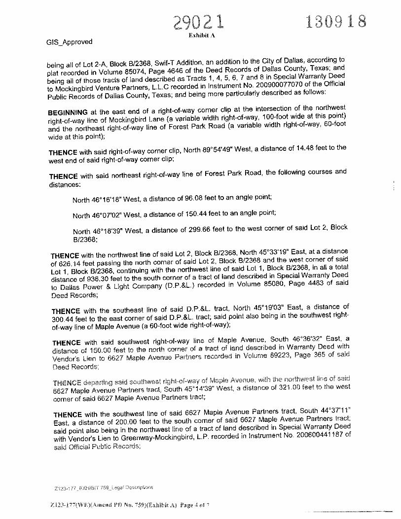
being all of Lot 2-A, Block B/2368, Swif-T Addition, an addition to the City of Dallas, according to
plat recorded in Volume 85074, Page 4646 of the Deed Records of Dallas County, Texas; and
being all of those tracts of land described as Tracts 1, 4, 5, 6, 7 and 8 in Special Warranty Deed
to Mockingbird Venture Partners, LLC recorded in Instrument No. 200900077070 of the Official
Public Records of Dallas County, Texas; and being more particularly described as follows:
BEGINNING at the east end of a right-of-way corner clip at the intersection of the northwest
right-of-way line of Mockingbird Lane (a variable width right-of-way, 100-foot wide at this point)
and the northeast right-of-way line of Forest Park Road (a variable width right-of-way, 60-foot
wide at this point):
THENCE with said right-of-way corner clip, North 89°54’49” West, a distance of 14.48 feet to the
west end of said right-of-way corner clip;
THENCE with said northeast right-of-way line of Forest Park Road, the following courses and
distances:
North 46°16’18” West, a distance of 96.08 feet to an angle point;
North 46°0T02” West, a distance of 150.44 feet to an angle point;
North 46°18’39” West, a distance of 299.66 feet to the west corner of said Lot 2, Block
B/2368;
THENCE with the northwest line of said Lot 2, Block B12368, North 45°33’l 9” East, at a distance
of 626.14 feet passing the north corner of said Lot 2, Block 8/2368 and the west corner of said
Lot 1, Block B/2368, continuing with the northwest line of said Lot 1, Block 8/2368, in all a total
distance of 936.30 feet to the south corner of a tract of land described in Special Warranty Deed
to Dallas Power & Light Company (D.P.&L) recorded in Volume 85080, Page 4483 of said
Deed Records;
THENCE with the southeast line of said D.P.&L tract, North 45°19’03” East, a distance of
300.44 feet to the east corner of said D.P.&L. tract; said point also being in the southwest right-
of-way line of Maple Avenue (a 60-foot wide right-of-way);
THENCE with said southwest right-of-way line of Maple Avenue. South 46°36’32” East, a
distance of 15000 feet to the north corner of a tract of land described in Warranty Deed with
Vendor’s Lien to 6627 Maple Avenue Partners recorded in Volume 89223, Page 365 of said
Deed Records;
THENCE departing said southwest right-of-way of Maple Avenue, with the northwest line of said
6627 Maple Avenue Partners tract, South 45”14’39” West, a distance of 321.00 feet to the west
corner of said 6627 Maple Avenue Partners tract;
THENCE with the southwest line of said 6627 Maple Avenue Partners tract, South 44°37’l 1”
East, a distance of 20000 feet to the south corner of said 6627 Maple Avenue Partners tract;
said point also being in the northwest line of a tract of land described in Special Warranty Deed
with Vendor’s Lien to Greenway-Mockingbird, L.P. recorded in instrument No. 200600441187 of
said Official Public Records;
Zi.23-177(WE)(Amend PD No, 759XExhibit A) Page 4 of 7
29021 1:30918Exhibit A
G IS Approved
THENCE with said northwest line of said Greenway-Mockingbird, L.P. tract, South 45°16’38”
West, a distance of 288.95 feet to the west corner of said Greenway-Mockingbird, L.P. tract;
THENCE with the southwest line of the Greenway-Mockingbird, L.P. tract, South 45°34’23”
East, a distance of 214.00 feet to the south corner of said Greenway-Mockingbird, L.P. tract;
said point also being in said northwest right-of-way line Mockingbird Lane;
THENCE with said northwest right-of-way line of Mockingbird Lane, South 46°27’54” West, a
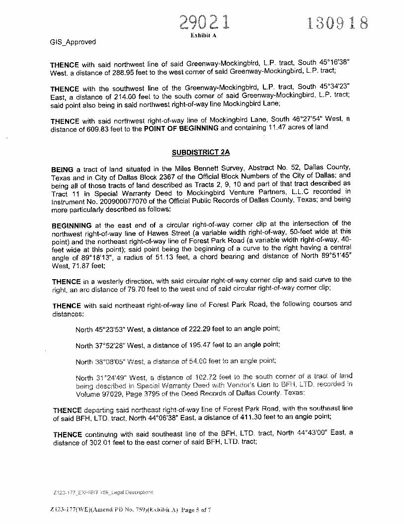
distance of 609.83 feet to the POINT OF BEGINNING and containing 11.47 acres of land.
SUBDISTRICT 2A
BEING a tract of land situated in the Miles Bennett Survey, Abstract No. 52, Dallas County,
Texas and in City of Dallas Block 2367 of the Official Block Numbers of the City of Dallas; and
being all of those tracts of land described as Tracts 2, 9, 10 and part of that tract described as
Tract 11 in Special Warranty Deed to Mockingbird Venture Partners, L.L.C recorded in
Instrument No. 200900077070 of the Official Public Records of Dallas County, Texas; and being
more particularly described as follows:
BEGINNING at the east end of a circular right-of-way corner clip at the intersection of the
northwest right-of-way line of Hawes Street (a variable width right-of-way, 50-feet wide at this
point) and the northeast right-of-way line of Forest Park Road (a variable width right-of-way, 40-
feet wide at this point); said point being the beginning of a curve to the right having a central
angle of 89°18’13”, a radius of 51.13 feet, a chord bearing and distance of North 89°51’45”
West, 71.87 feet;
THENCE in a westerly direction, with said circular right-of-way corner clip and said curve to the
right, an arc distance of 79.70 feet to the west end of said circular right-of-way corner clip;
THENCE with said northeast right-of-way line of Forest Park Road, the following courses and
distances:
North 45°23’53” West, a distance of 222.29 feet to an angle point;
North 37°52’28” West, a distance of 195.47 feet to an angle point;
North 3808’05” West, a distance of 54.00 feet to an angle point;
North 3i24’4S” West, a distance of 102.72 feet to the south corner of a tract of land
being described in Special Warranty Deed with Vendors Lien to BFH, LTD. recorded in
Volume 97029, Page 3795 of the Deed Records of Dallas County, Texas;
THENCE departing said northeast right-of-way line of Forest Park Road, with the southeast line
of said BFH, LTD. tract, North 44°06’38” East, a distance of 411.30 feet to an angle point;
THENCE continuing with said southeast line of the BFH, LTD. tract, North 44°43’OO” East, a
distance of 302.01 feet to the east corner of said BFH, LTD. tract;
ZI23-17WE(Arned PD No, 59)(ExhIbit A) Page 5 of 7
01 130318Exhibit A
GIS_Approved
THENCE North 49°5619” East, a distance of 328.31 feet to the south corner of a tract of land
described in Warranty Deed to City of Dallas recorded in Volume 81201, Page 1192 of said
Deed Records;
THENCE with the southeast line of said City of Dallas tract, North 43°51’03” East, a distance of
107.49 feet to the east corner of said City of Dallas tract; said point also being in the southwest
line of a tract of land described in Warranty Deed to Bill Booziotis recorded in Volume 84046,
Page 2529 of said Deed Records;
THENCE with said southwest line of the Bill Booziotis tract, South 45°1 1’57” East, a distance of
291.54 feet to the south corner of said Bill Booziotis tract; said point also being the west corner
of that tract of land described as Tract 3 in said Special Warranty Deed to Mockingbird Venture
Partners, L.L.C.;
THENCE, with the southwest line of said Tract 3, South 45°00’12” East, a distance of 351.42
feet to the south corner of said Tract 3; said point also being in the northwest line of Lot 1 Block
B12368, Forest Park, an addition to Dallas County, according to the plat recorded in Volume
241, Page 41 of the Map Records of Dallas County, Texas;
THENCE with the northwest line of said Lot 1, Block B12368, South 45°33’19’ West, at a
distance of 152.95 feet passing the west corner of said Lot 1, Block B/2368 and the north corner
of Lot 2, Block B/2368 of said Forest Park addition, continuing with the northwest line of said Lot
2, Block B/2368, in all a total distance of 779.09 feet to the west corner of said Lot 2, Block
B/2368; said point also being in said northeast right-of-way line of Forest Park Road (60-feet
wide at this point);
THENCE with said northeast right-of-way line of Forest Park Road, North 46°18’39” West, a
distance of 29.85 feet to the intersection of said northeast right-of-way line of Forest Park Road
and said northwest right-of-way line of Hawes Street;
THENCE with said northwest right-of-way line of Hawes Street, South 45°29’Og” West, a
distance of 371.72 feet to the POINT OF BEGINNING and containing 17.60 acres of land.
SUBDISTRICT 2B
BEING a tract of land situated in the Miles Bennett Survey, Abstract No, 52, Dallas County,
Texas and in City of Dallas Block 2367 of the Official Block Numbers of the City of Dallas; and
being part of that tract of iand described as Tract 11 in Special Warranty Deed to Mockingbird
Venture Partners, L.L.C recorded in instrument No. 200900077070 of the Official Public
Records of Dallas County, Texas; and being all of a 10-foot wide alley across Block B/2367,
Heartsill Addition, an addition to the City of Dallas, according to the plat recorded in Volume 10,
Page 269 of said Map Records; and being more particularly described as follows:
BEGINNING at the intersection of the southeast right-of-way line of Empire Central (a 50-foot
wide right-of-way) and the northeast line of said 10-foot wide alley across Block B/2367;
THENCE with said northeast line of the 10-foot wide alley across Block B/2367, South 45°10’33”
East, a distance of 300.32 feet to the east end of the southeast terminus of said 10-foot wide
alley and the south corner of Lot 4, Block B/2367 of said Heartsill Addition:
LI23-l7W[)(Amend PD o, 759)(Exhibit A) Page 6 of
9O21 13OqExhibit A 8
G IS_Approved
THENCE with the southeast line of said Lot 4, Block B/2367, North 43°45’13” East, a distance of
100.00 feet to the east corner of said Lot 4, Block B12367; said point also being in the southwest
right-of-way line of Mohawk Street (a 50-foot wide right-of-way);
THENCE with said southwest right-of-way line of Mohawk Street, South 45°13’57” East, a
distance of 25.00 feet to the south end of the southeast terminus of Mohawk Street;
THENCE with said southeast terminus of Mohawk Street, North 43°51’03” East, a distance of
50.01 feet to the east end of said southeast terminus of Mohawk Street; said point also being
the south corner of Lot 4, Block A12367 of said Heartsill Addition and in the southwest line of a
tract of land described in Warranty Deed to City of DaHas recorded in Volume 81201, Page
1192 of the Deed Records of Dallas County, Texas;
THENCE with said southwest line of the City of Dallas tract, South 45°1 1’57” East, a distance of
100.00 feet to the south corner of said City of Dallas tract;
THENCE South 49°56’19” West, a distance of 328.31 feet to the east corner of a tract of land
being described in Special Warranty Deed with Vendor’s Lien to BFH, LTD. recorded in Volume
97029, Page 3795 of said Deed Records;
THENCE with the northeast line of said BFH, LTD. tract, North 45°13’36” West, passing at a
distance of 110.43 feet the northernmost corner of said BFH, LTD. tract recorded in Volume
97029, Page 3795 and the east corner of a tract of land described in Special Warranty Deed to
BFH, LTD. recorded in Instrument No. 20080003338 of said Official Public Records, continuing
along the northeast line of said BFH, LTD. tract recorded in Instrument No. 20080003338, in all
a total distance of 392.10 feet to the north corner said BFH, LTD. tract recorded in Instrument
No. 20080003338; said point also being in said southeast right-of-way line of Empire Central;
THENCE with said southeast right-of-way line of Empire Central, North 44°25’39” East, passing
at a distance of 167.31 feet the intersection of said southeast right-of-way line of Empire Central
and the southwest line of said 10-foot wide alley across Block B/2367, continuing in all a total
distance of 177.31 feet to the POINT OF BEGINNING and containing 2.00 acres of land.
Bearing system for this survey is based on the North American Datum of 1983, Texas State
Plane Coordinate System, North Central Texas, Zone 4202,
This document was prepared under 22 TAC §663.21, does not reflect the results of an on the
ground survey, and is not to be used to convey or establish interests in real property except
those rights and interests implied or established by the creation or reconfiguration of the
boundary of the political subdivision for which ii was prepared.
ZI23-I77(WE)(Arne)d PD No. 759)( Exhibit A) Page 7 of 7