27
SPECIAL ORDINARY COUNCIL MEETING Attachments 14 February 2011 Ordinary Council 14/02/11 Item 10.1 refers Attachment 3 Draft Guidelines

SPECIAL ORDINARY COUNCIL MEETING Attachments 14 February 2011
Ordinary Council 14/02/11
Item 10.1 refers
Attachment 3
Draft Guidelines
SPECIAL ORDINARY COUNCIL MEETING Attachments 14 February 2011
Ordinary Council 14/02/11
Item 10.1 refers
Attachment 4
Modifications to the Scheme
Scheme Map Changes
Increase density to R20/40 along Kooyong Road between Macey Close to Great Eastern Highway.
Increase density to R20/40 to include lots on the northeast side of Fisher St between the Parks and Recreation Reserve and Fulham Street, and extending along the west side of Fulham Street to Belgravia Street and including No. 129 and No. 130 Arlunya Ave and No. 314 Belgravia St.
Increase density to maintain the R20/40 code for the entire street block bounded by Belgravia St, Gabriel St, Fisher St and Fulham St.
Increase density to R20/40 for No. 38 Wright Street and the balance of lots fronting each side of Wright Street, between Surrey Road and St Kilda Road.
Increase density to R20/40 for No. 70 Wright Street and the balance of lots fronting each side of Wright Street, between Surrey Road and St Kilda Road.
Retain R20 in Martin Ave (north east side) between No. 1 Martin Ave through to Tranby Primary School and also No. 14 Lot 51 Cleaver Tce.
Increase density to R20/40 for residential lots on the south west side of Epsom Avenue (between Durban St and GEH), and being all those lots including and between No. 64 Epsom Ave to No. 102 Epsom Ave.
Increase density to R20/40 for the street blocks bounded by : Epsom Avenue, Smiths Avenue, Moreing Street and Stanton Road; and Epsom Avenue, Smiths Avenue, Moreing Street and Victoria Street.
Increase density to R20/40 for 3, 4, 5, 6, 7, 8, 9, 10, 11, 12, 13, 14, 15 & 16 Priske Way; 94, 96, 100, 102, 104 & 106 Roberts Road; and 171, 173, 175 & 179 Surrey Road, Rivervale.
Increase density to R20/40 for the entire street block bounded by Keymer St, Stanley St, Hardey Rd, Durban St.
Increase density to R20/40 for all lots in Beagle Place and including and between No.3 to No.17 Williamson Ave and No.3 and No.5 Atwell Street, which is consistent with the balance of street block bounded by Williamson Avenue, Atwell St, Hardey Rd and Frederick St and to recode No. 8 and No. 10 Atwell Street to R20/40.
Increase density to R20/40 for all of No. 88, Lot 1171 Alexander Road. Retain No. 193, Lot 47 Acton Avenue with an R20 code.
Increase density to R20/40 for all lots fronting Pontiac Avenue and the south side of Oakland Ave (between Forster Park and Gabriel St), consistent with the balance of the street block.
Increase density to R20/40 for No. 90 Lot 100 Oats Street and No.324 Lot 101 Acton Street, cnr Oats.
Retain all lots on the south west side of Armadale Road between Campbell Street and Roberts Street as R20 (the R20/40 only relates to the existing R20/40 codes lots which front Fitzroy St and between Campbell and Roberts Street).
Rezone 1 and 3 Grand Parade, Redcliffe to Residential R20
Rezone Lot 43 (275) Belmont Avenue from Public Purpose to Mixed Use.
Show Lot 151 (No. 200) Great Eastern Highway, Ascot with an Additional Use designation.
Show Lot 288 (137) Kewdale Road, Kewdale with an Additional Use designation.
Amend Scheme Map Legend to refer to Schedule 12 for Development Areas.
Amend Scheme Map reference to „The Springs‟ Special Development Precinct to be uniform
with all the other special development precincts.
Amend Scheme Map reference to Notre Dame Primary School and St Maria Goretti Primary
School to PPS.
Amend Scheme Map cnr Fauntleroy and Redcliffe to delete reference to MTT and replace with
T (transperth or transport depot).
Amend Scheme Map Legend to remove reference to R Codes before Housing Strategy.
Scheme Text Changes Adding to clause 1. 6: (i) To protect and maximise efficacy of existing and future community infrastructure
needs. Correct typographical error page 4 Part 2.4.2 spelling of “local”. Modifying clause 4.2 „Objectives of Zones‟ for the Residential and Stables Zone as follows: The Residential and Stables Zone is intended to provide for compatible and environmentally responsible use of land in proximity to the Ascot Racecourse and the Swan River by residential accommodation and stables and ancillary functions of the horse racing industry. Amending Table 1 „Zoning Table‟:
The designation of „Office‟ within the Industrial zone be amended from „X‟ to „A‟. In the event that the Hon Minister does not support „Offices‟ as an „A‟ use, it is recommended that all properties fronting Abernethy Road be included in Schedule No. 2 Additional Uses whereby Council may approve the Additional Use of Office.
Logistics Centre should be added to Table 1 Zoning Table and made X in all zones with the exception of the Mixed Business zone (A) and Industrial zone (D).
Delete „Warehouse Retail‟ from the Zoning Table
Sex Related Use be made an „X‟ prohibited use in the Town Centre zone
Noxious Industry should be amended to an „A‟ use in the Industrial zone.
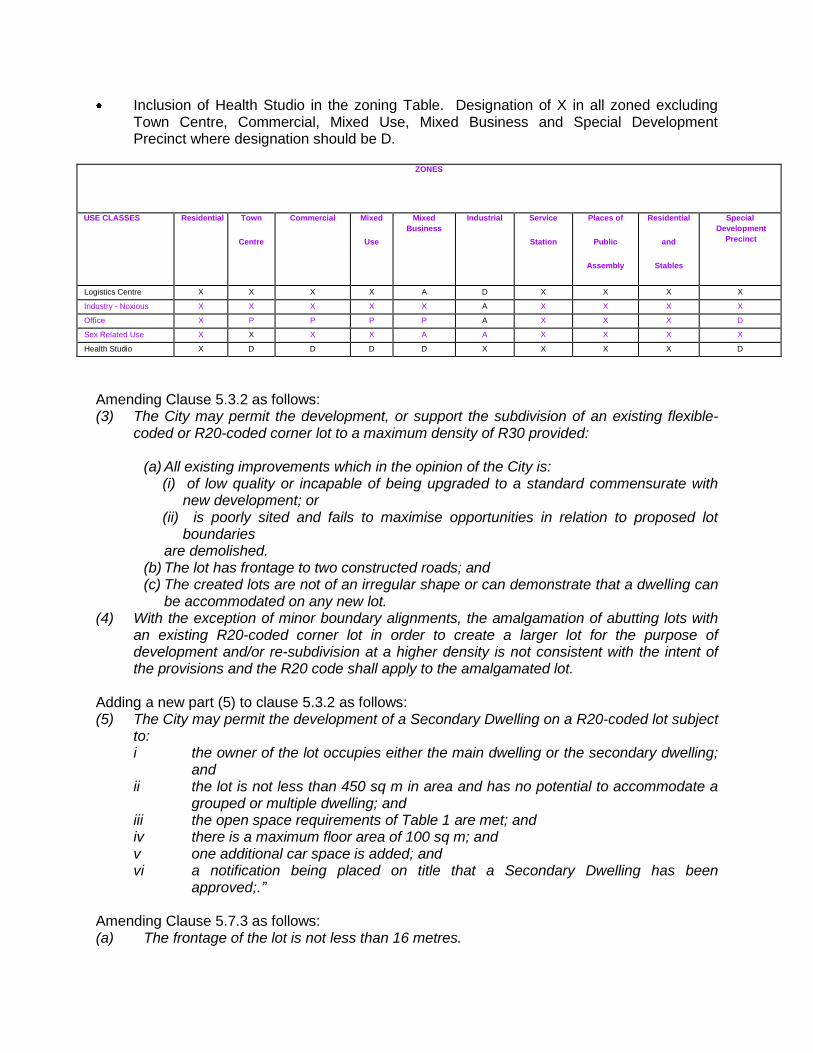
Inclusion of Health Studio in the zoning Table. Designation of X in all zoned excluding Town Centre, Commercial, Mixed Use, Mixed Business and Special Development Precinct where designation should be D.
ZONES
USE CLASSES Residential Town
Centre
Commercial Mixed
Use
Mixed
Business
Industrial Service
Station
Places of
Public
Assembly
Residential
and
Stables
Special
Development
Precinct
Logistics Centre X X X X A D X X X X
Industry - Noxious X X X X X A X X X X
Office X P P P P A X X X D
Sex Related Use X X X X A A X X X X
Health Studio X D D D D X X X X D
Amending Clause 5.3.2 as follows: (3) The City may permit the development, or support the subdivision of an existing flexible-
coded or R20-coded corner lot to a maximum density of R30 provided:
(a) All existing improvements which in the opinion of the City is: (i) of low quality or incapable of being upgraded to a standard commensurate with
new development; or (ii) is poorly sited and fails to maximise opportunities in relation to proposed lot
boundaries are demolished.
(b) The lot has frontage to two constructed roads; and (c) The created lots are not of an irregular shape or can demonstrate that a dwelling can
be accommodated on any new lot. (4) With the exception of minor boundary alignments, the amalgamation of abutting lots with
an existing R20-coded corner lot in order to create a larger lot for the purpose of development and/or re-subdivision at a higher density is not consistent with the intent of the provisions and the R20 code shall apply to the amalgamated lot.
Adding a new part (5) to clause 5.3.2 as follows: (5) The City may permit the development of a Secondary Dwelling on a R20-coded lot subject
to: i the owner of the lot occupies either the main dwelling or the secondary dwelling;
and ii the lot is not less than 450 sq m in area and has no potential to accommodate a
grouped or multiple dwelling; and iii the open space requirements of Table 1 are met; and iv there is a maximum floor area of 100 sq m; and v one additional car space is added; and vi a notification being placed on title that a Secondary Dwelling has been
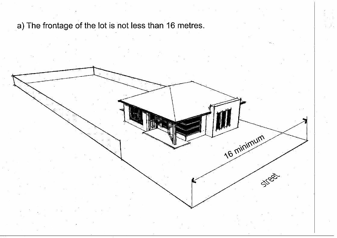
approved;.” Amending Clause 5.7.3 as follows: (a) The frontage of the lot is not less than 16 metres.
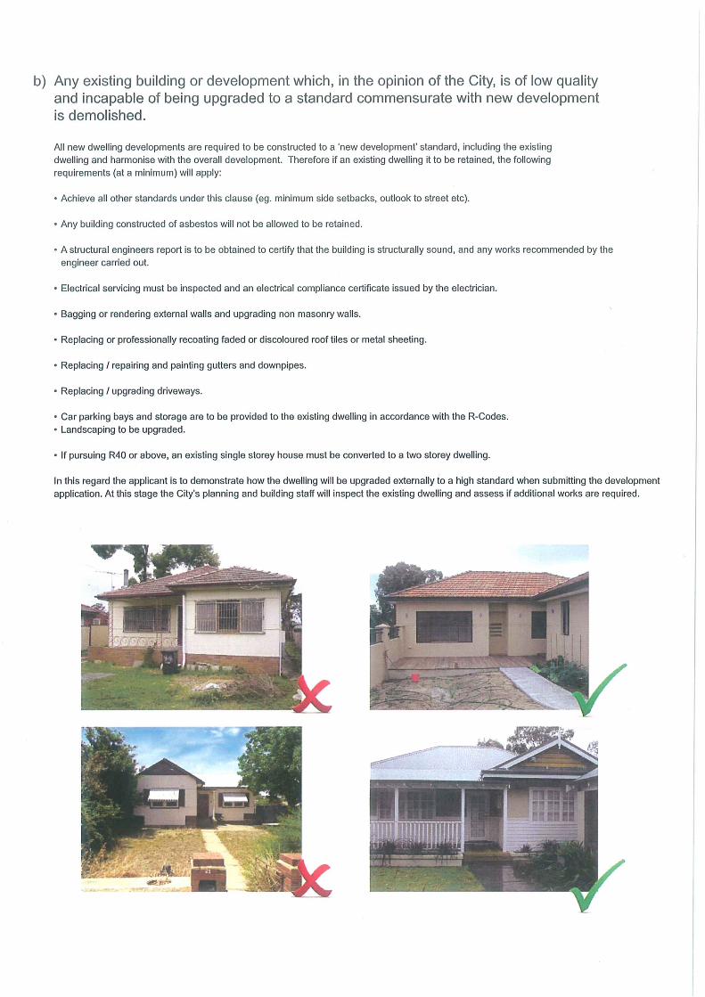
(b) Any existing building or development which, in the opinion of the City, is of low quality and incapable of being upgraded to a standard commensurate with new development is demolished; and
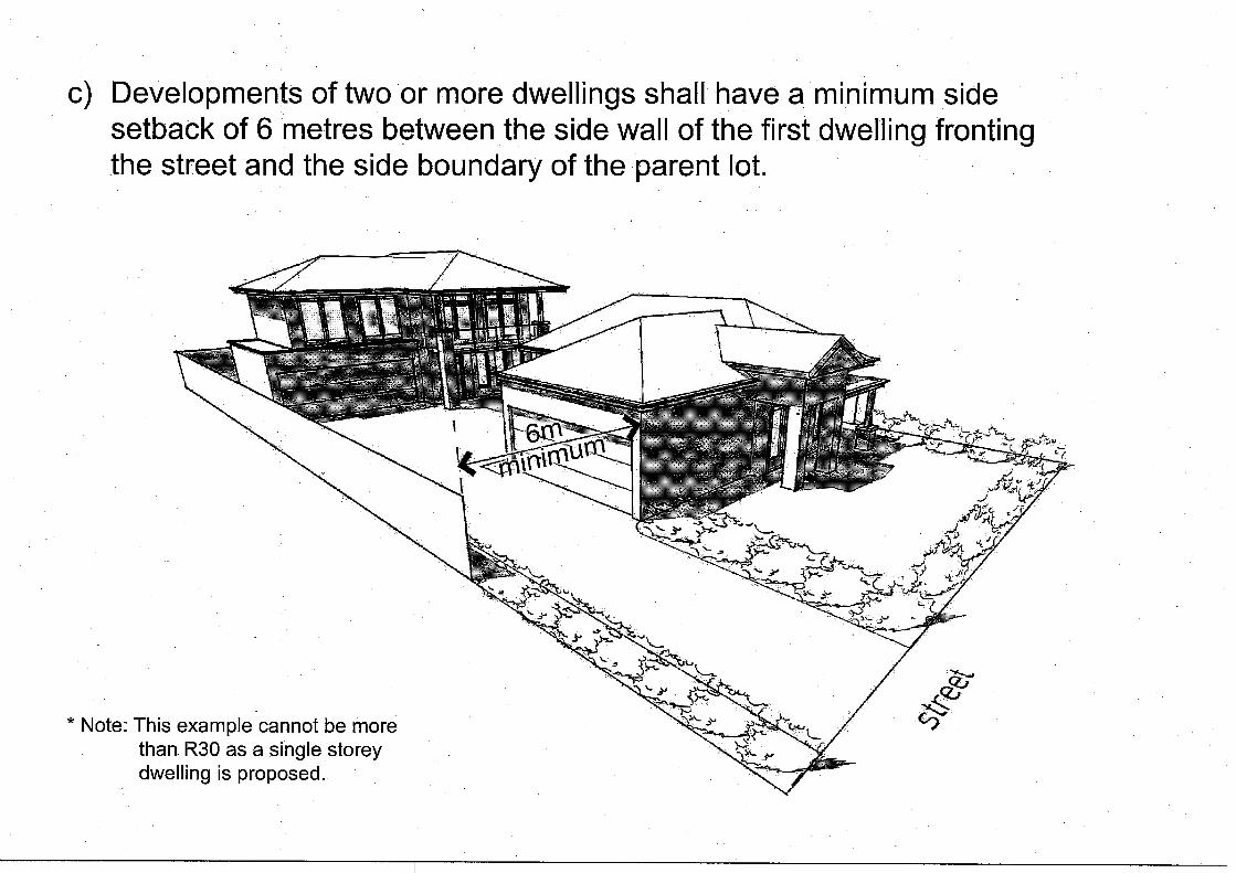
(c) Developments of two or more dwellings shall have a minimum side setback of 6 metres between the side wall of the first dwelling fronting the public street and the side boundary of the parent lot; and
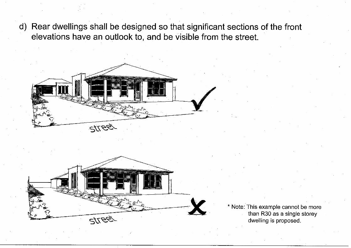
(d) Rear dwellings shall be designed so that significant sections of the front elevations have an outlook to, and be visible from the public street; and
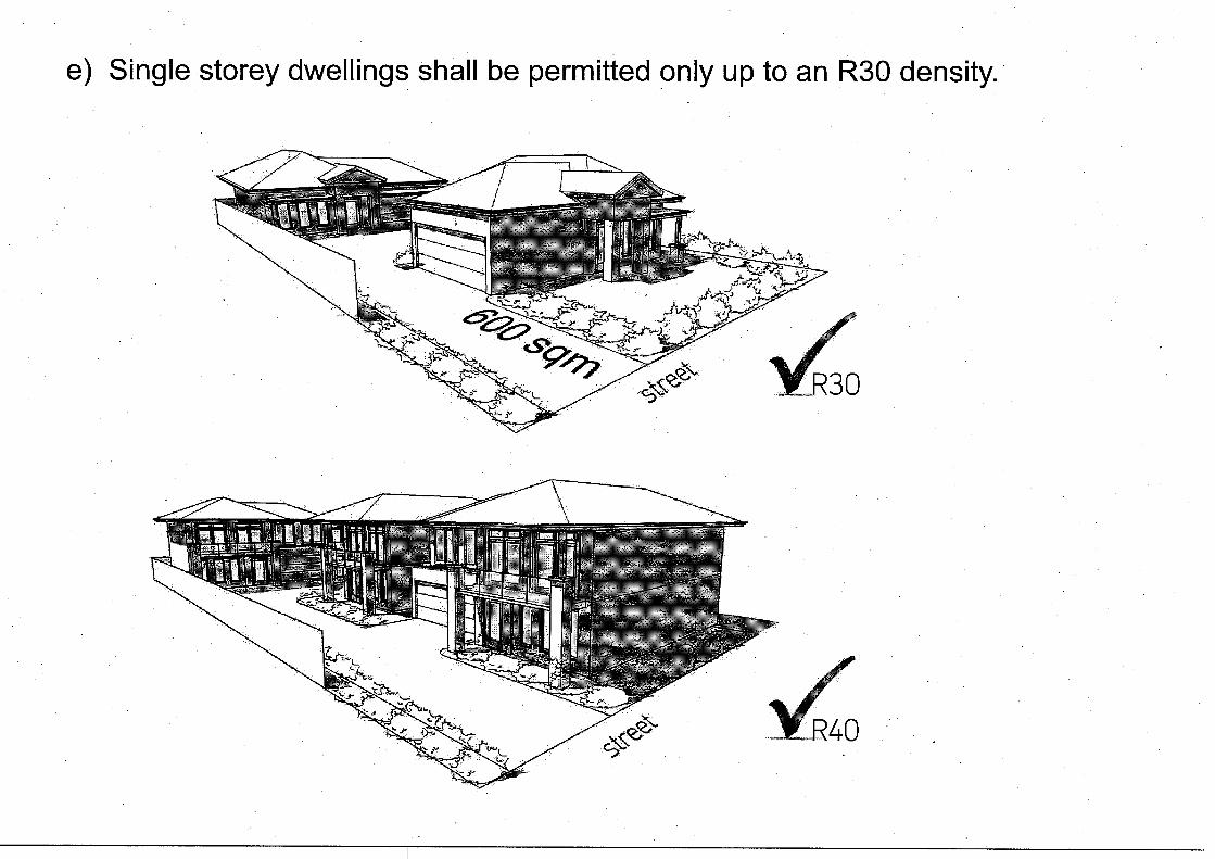
(e) Single storey dwellings shall be permitted only up to an R30 density with a mix of single and two storey dwellings up to a density of R40 provided that 50% or greater of the dwellings are two storey; and
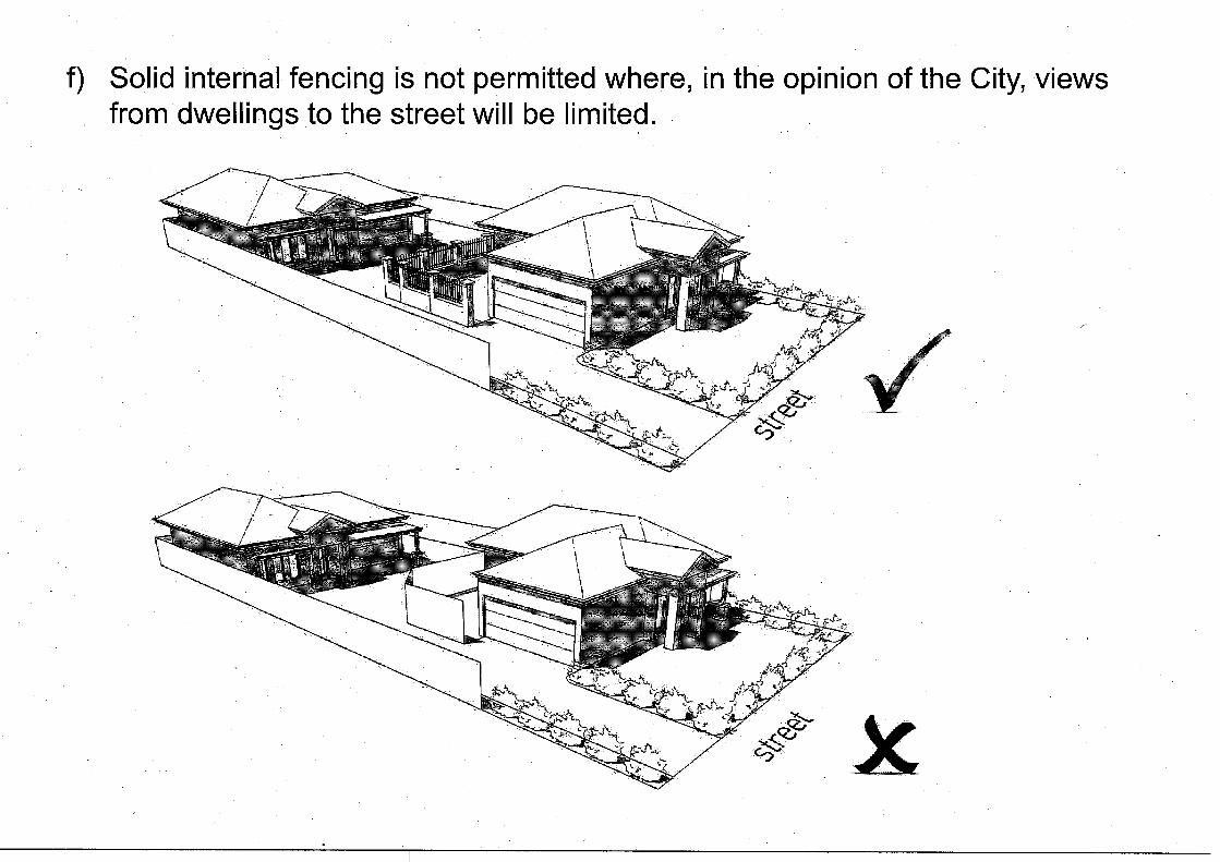
(f) Solid external or internal fencing is not permitted where, in the opinion of the City, views from dwellings to the public street will be limited; and
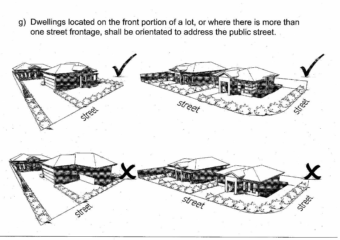
(g) Dwellings located on the front portion of a lot, or where there is more than one street frontage, shall be oriented to address the public street(s); and
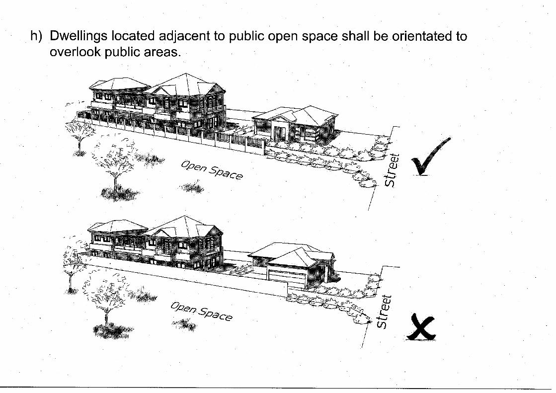
(h) Dwellings located adjacent to public open space shall be oriented to provide informal surveillance of public areas; and
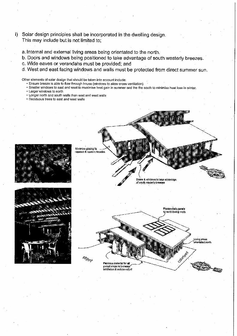
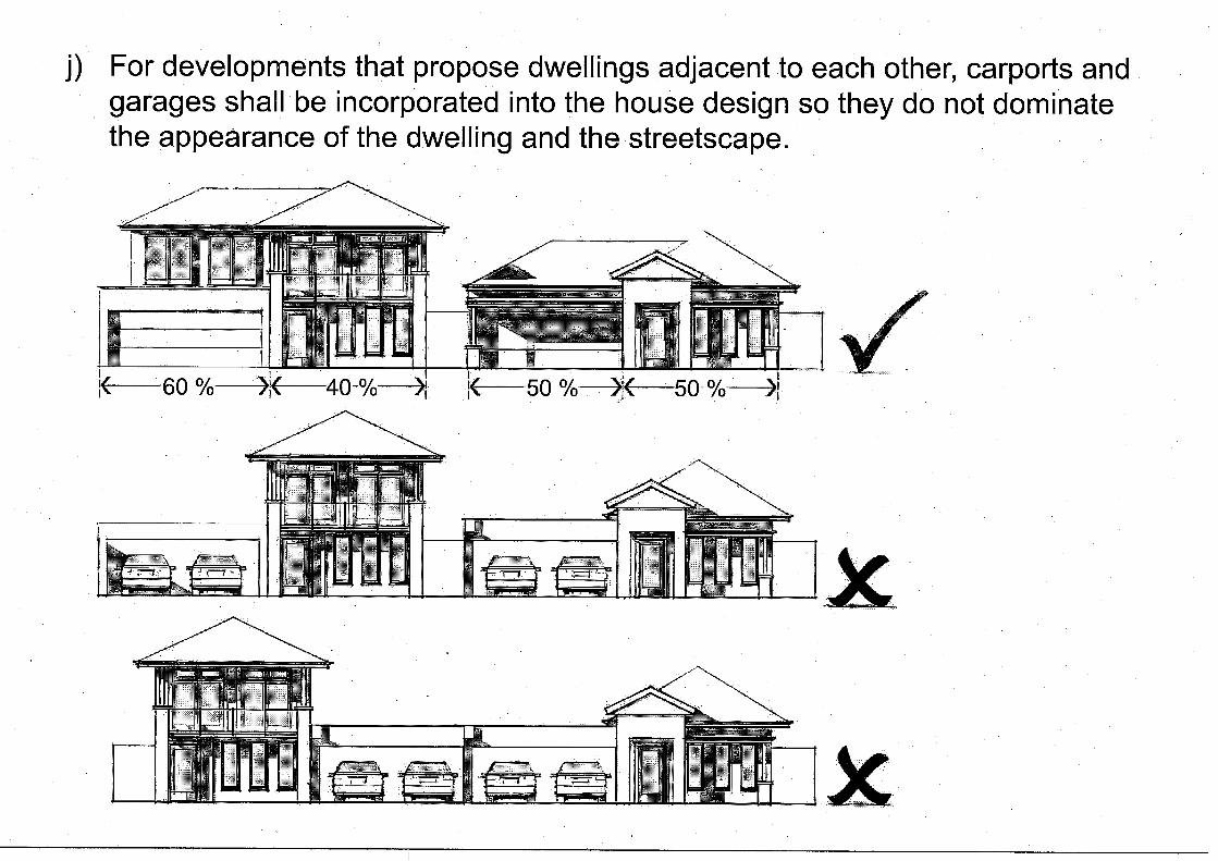
(i) Solar design principles shall be incorporated in the dwelling design. (j) For developments that propose dwellings adjacent to each other, carports and garages
shall be incorporated into the house design so they do not dominate the appearance of the dwelling and the streetscape; and
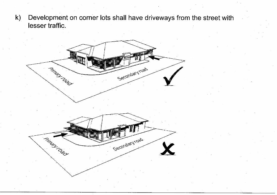
(k) Development on corner lots or lots with more than one frontage shall have driveways from the street with lesser traffic; and
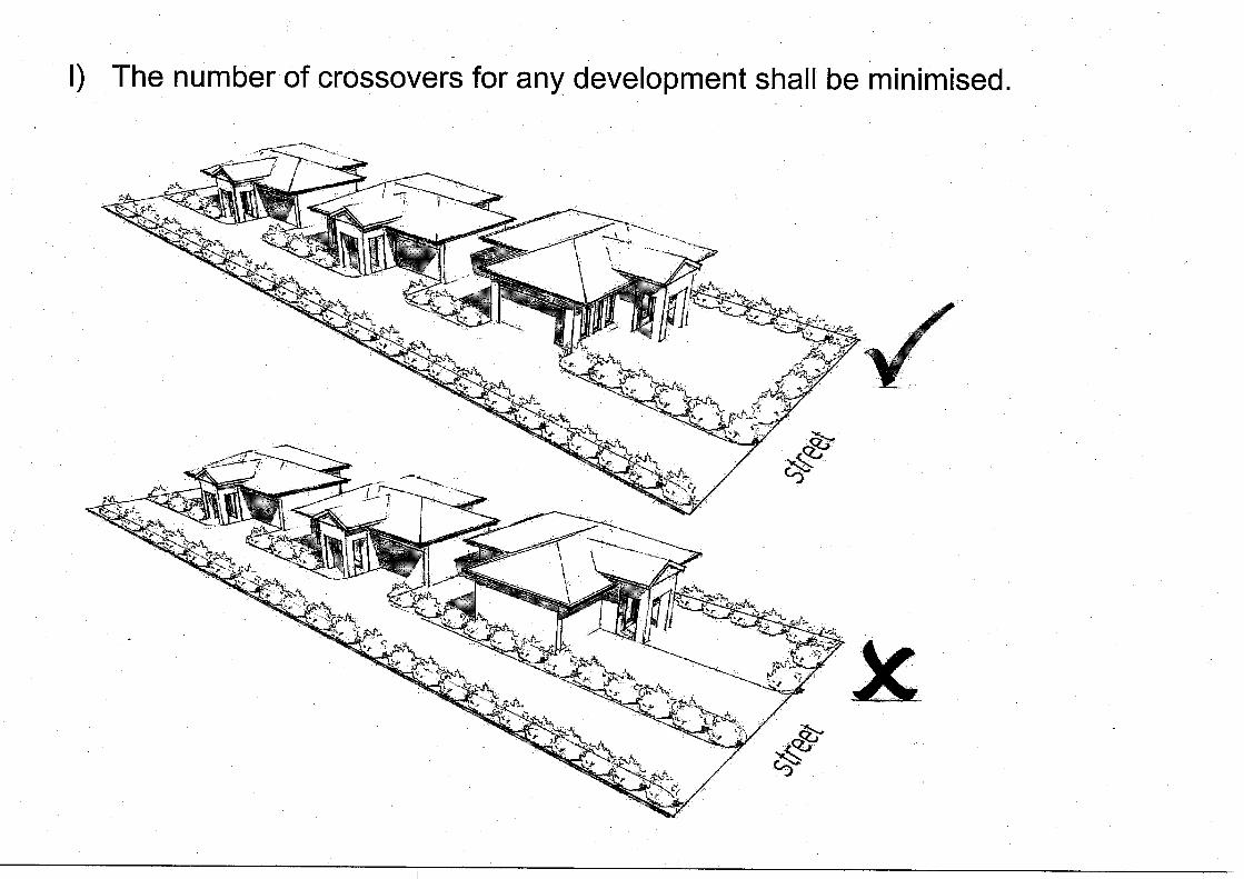
(l) The number of crossovers for any development shall be minimised. Amend Subclause 5.7.9 Floodway Limit Boundary as follows: “No building shall be constructed upon any land within the floodway limit boundary prescribed on the Western Australia Water-Authority Swan River Flood Study Review 1985 or those maps as modified by the Department of Water.” Amend clause 5.9.5 As follows: “An application for Planning Approval for a stables use only or a residence only shall comply with subclause 5.9.4 and make provision for the possibility of locating both a residence and a minimum of two stables on the lot.” Amend clause 5.16.4 (2) as follows: “Layout of parking spaces shall be in accordance with Schedule No. 11 or, at the discretion of Council, the relevant Australian Standard.” Amend Section 5.16.5, item 2, “bay size” by adding “standard” to car parking space and “construction cost” and adding “including the manoeuvring area and associated services” after “size”. The construction cost for the car bay shall include the aisle and reversing space, and servicing of the car parking facility. Delete of part (b) of clause 5.20. Amend Clause 6.3.1 Interpretation of Infrastructure to refer to Appendix 1 of the WAPC Statement of Planning Policy 3.6. Adding clause 7.1.7 as follows:
“Existing Heritage List Any Heritage List in existence at the time of the gazettal of the Scheme is to have the effect of a Heritage List under the Scheme provided it was made under procedures similar to those in the Scheme.” Modifying Clause 8.2 (b) as follows: "(vi) The development abuts the Development Control Area or in the opinion of Council is likely to impact the quality of waters In the DCA'. Correct formatting of numbers Part 8.2 items g, h, i & j. Amend Clause 8.2(k) as follows: “patios and pergolas for single, grouped or multiple dwellings where located behind the front setback notwithstanding any variance to the Residential Design Codes;” Modifying Note 2 for Subclause 9.1.2 to reference “the Minister responsible for the Swan and Canning Rivers Management Act 2006." Clause 8.2(g) (ii) to be reworded as follows: “The boundary fence is located in the street setback area in land zoned Residential or Residential and Stables where the fence is less than 1.8metres in height when measured from natural ground level and is not visually permeable from 1.2 metres above natural ground level; Formatting of numbers Part 8.2 items g, h, i & j to be corrected. Modifying Schedule No. 1 Dictionary of Defined Words and Expressions as follows:
Include in Schedule No. 1 General Definitions a definition of the Swan River Trust's Development Control Area “as defined under the Swan and Canning Rivers Management Act 2006”. The definition of „Warehouse‟ be amended as follows: “means premises used to store or display goods and includes premises on the same land used for — (a) the work of administration or accounting; (b) the selling of goods by wholesale; or (c) the provision of amenities for employees, incidental to any of those warehouse operations;” It is recommended that a new definition of „Logistics centre‟ be added to Schedule 1 of draft LPS 15 as follows: A Logistics Centre “means land within which all activities relating to transport, logistics, warehousing and the distribution of goods are carried out and includes premises on the same land used for - (a) the work of administration or accounting; (b) the provision of amenities for employees, incidental to any of those logistics operations;” Amend the definition of Industry – noxious (or noxious industry) as follows:
“means any industry which causes premises to be defined as “Prescribed Premises” or “Premises Subject to Registration” under the Environment Protection Act 1986;” Including a definition of „Secondary Dwelling‟ as follows: “means an additional dwelling or independent accommodation associated with a single house and on the same lot where: i the owner of the lot occupies either the main dwelling or the secondary dwelling; ii the lot is not less than 450 sq m in area and has no potential to accommodate a
grouped or multiple dwelling; iii the open space requirements of Table 1 are met; iv there is a maximum floor area of 100 sq m; and v one additional car space is added.”
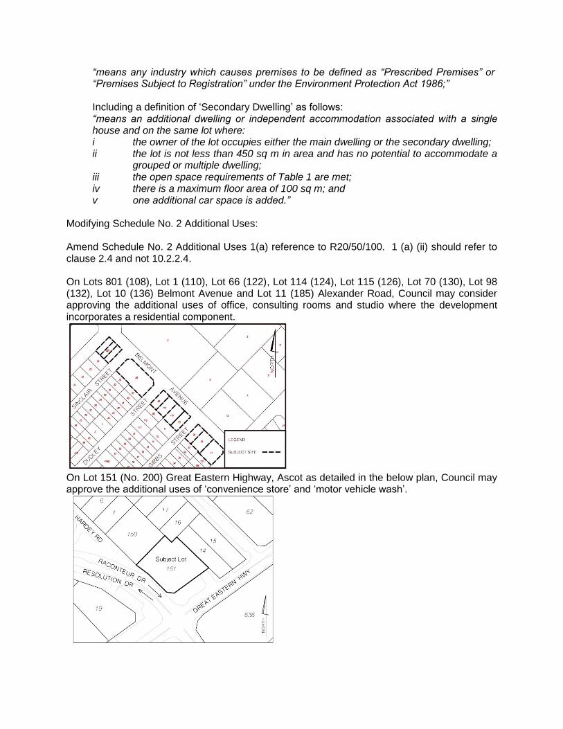
Modifying Schedule No. 2 Additional Uses: Amend Schedule No. 2 Additional Uses 1(a) reference to R20/50/100. 1 (a) (ii) should refer to clause 2.4 and not 10.2.2.4. On Lots 801 (108), Lot 1 (110), Lot 66 (122), Lot 114 (124), Lot 115 (126), Lot 70 (130), Lot 98 (132), Lot 10 (136) Belmont Avenue and Lot 11 (185) Alexander Road, Council may consider approving the additional uses of office, consulting rooms and studio where the development incorporates a residential component.
On Lot 151 (No. 200) Great Eastern Highway, Ascot as detailed in the below plan, Council may approve the additional uses of „convenience store‟ and „motor vehicle wash‟.
When considering applications for the establishment of the above uses, the following shall be taken into consideration:
The extent to which building(s) and structures on the site incorporate noise attenuation measures to limit the potential impact of noise on adjacent existing and future residential landuses.
Limiting the hours of operation of the „motor vehicle wash‟ so as to limit the impact of noise on adjacent existing and future residential landuses.
The extent to which the „motor vehicle wash‟ is designed to limit the potential for water spray impacts on adjoining existing and future residential landuses.
The extent to which the design and layout of proposed building/s and structures on the site are sympathetic to adjoining residential landuses.
The implementation of management measures on-site so as to assist with reducing the possibility of water-borne disease.
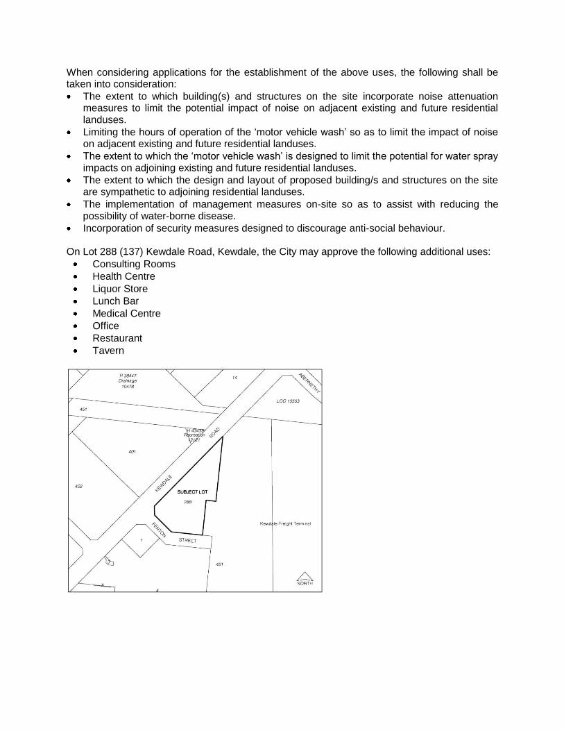
Incorporation of security measures designed to discourage anti-social behaviour. On Lot 288 (137) Kewdale Road, Kewdale, the City may approve the following additional uses:
Consulting Rooms
Health Centre
Liquor Store
Lunch Bar
Medical Centre
Office
Restaurant
Tavern
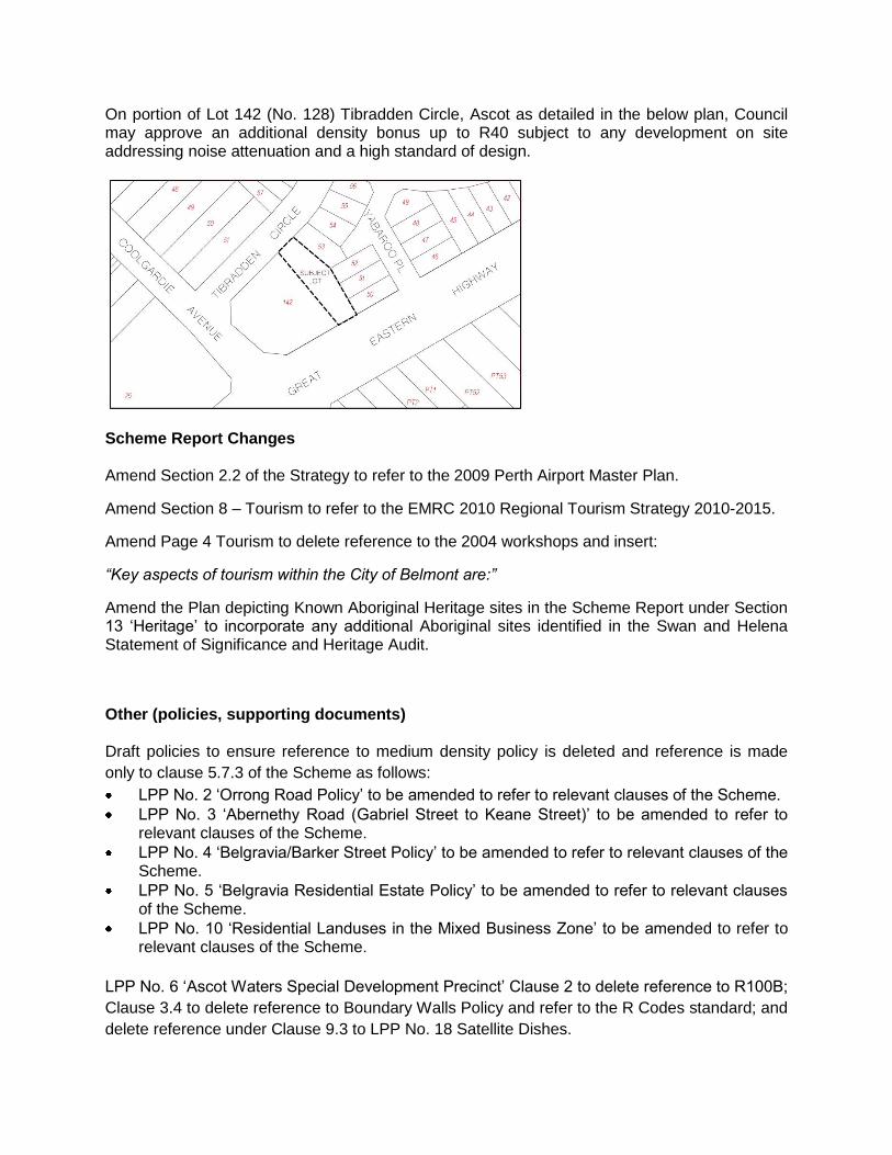
On portion of Lot 142 (No. 128) Tibradden Circle, Ascot as detailed in the below plan, Council may approve an additional density bonus up to R40 subject to any development on site addressing noise attenuation and a high standard of design.
Scheme Report Changes Amend Section 2.2 of the Strategy to refer to the 2009 Perth Airport Master Plan.
Amend Section 8 – Tourism to refer to the EMRC 2010 Regional Tourism Strategy 2010-2015.
Amend Page 4 Tourism to delete reference to the 2004 workshops and insert:
“Key aspects of tourism within the City of Belmont are:”
Amend the Plan depicting Known Aboriginal Heritage sites in the Scheme Report under Section 13 „Heritage‟ to incorporate any additional Aboriginal sites identified in the Swan and Helena Statement of Significance and Heritage Audit.
Other (policies, supporting documents) Draft policies to ensure reference to medium density policy is deleted and reference is made
only to clause 5.7.3 of the Scheme as follows:
LPP No. 2 „Orrong Road Policy‟ to be amended to refer to relevant clauses of the Scheme.
LPP No. 3 „Abernethy Road (Gabriel Street to Keane Street)‟ to be amended to refer to relevant clauses of the Scheme.
LPP No. 4 „Belgravia/Barker Street Policy‟ to be amended to refer to relevant clauses of the Scheme.
LPP No. 5 „Belgravia Residential Estate Policy‟ to be amended to refer to relevant clauses of the Scheme.
LPP No. 10 „Residential Landuses in the Mixed Business Zone‟ to be amended to refer to relevant clauses of the Scheme.
LPP No. 6 „Ascot Waters Special Development Precinct‟ Clause 2 to delete reference to R100B;
Clause 3.4 to delete reference to Boundary Walls Policy and refer to the R Codes standard; and
delete reference under Clause 9.3 to LPP No. 18 Satellite Dishes.
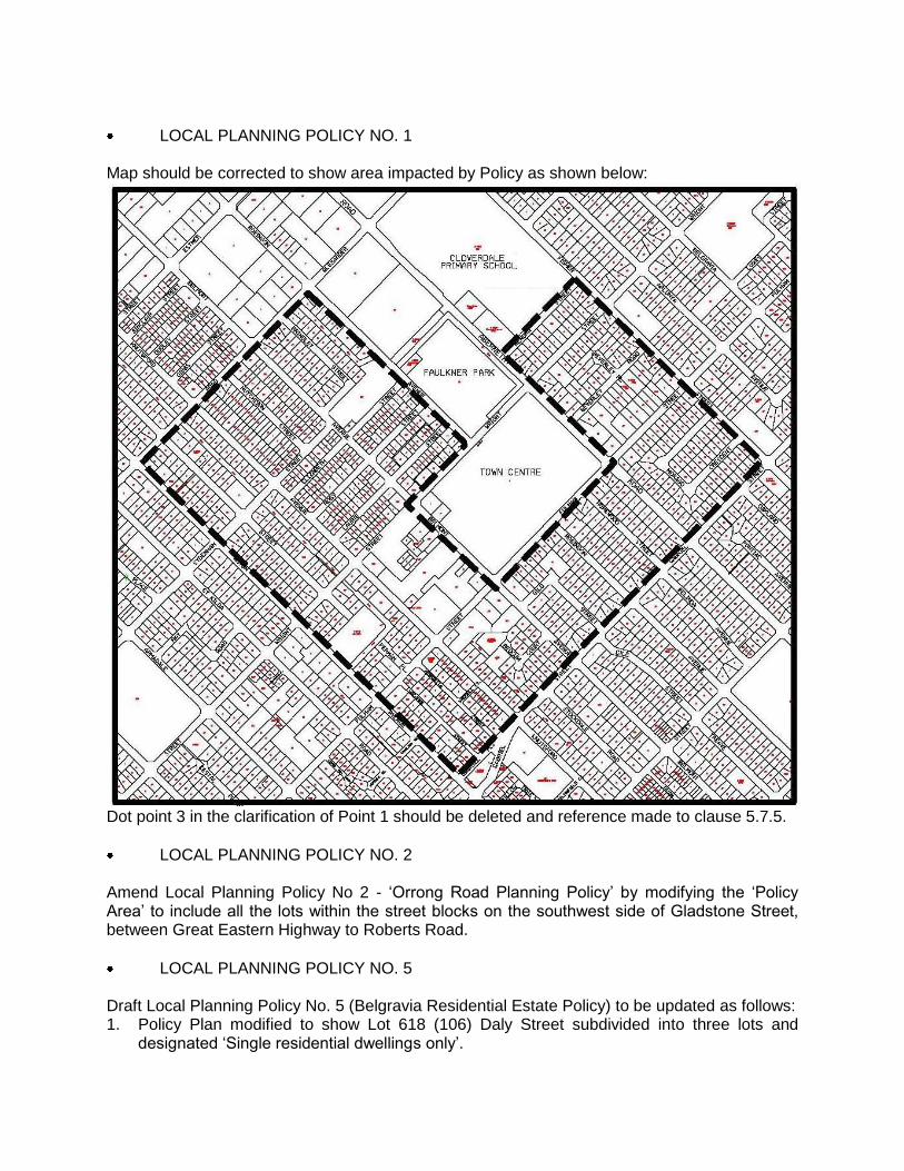
LOCAL PLANNING POLICY NO. 1 Map should be corrected to show area impacted by Policy as shown below:
Dot point 3 in the clarification of Point 1 should be deleted and reference made to clause 5.7.5.
LOCAL PLANNING POLICY NO. 2 Amend Local Planning Policy No 2 - „Orrong Road Planning Policy‟ by modifying the „Policy Area‟ to include all the lots within the street blocks on the southwest side of Gladstone Street, between Great Eastern Highway to Roberts Road.
LOCAL PLANNING POLICY NO. 5 Draft Local Planning Policy No. 5 (Belgravia Residential Estate Policy) to be updated as follows: 1. Policy Plan modified to show Lot 618 (106) Daly Street subdivided into three lots and
designated „Single residential dwellings only‟.
2. Policy Plan modified to show Lot 695 (65) Belgravia Street subdivided into three lots. The subject lot is designated Mixed Use in LPP22 Policy Plan and zoned Mixed Business with an Additional Use – Corner Store under the City‟s Town Planning Scheme No. 14.
3. Attachment A to the Policy (as shown below from Attachment No. 4 „Revised LPP22‟) – Policy Plan modified to show changes to Lot 618 (106) Daly Street and Lot 695 (65) Belgravia Street, Belmont.
4. Policy Statement modified to include point (i) Mixed Use Development guidelines which provides policy provisions relating to design, height, roof pitch, setbacks, parking, and landscaping requirements to facilitate a mix of high quality office and residential development on Lot 695 (65) Belgravia Street.
5. Attachment B to the Policy (refer to Attachment No. 4 „Revised LPP22‟) – Concept Plans Mixed Use Site to be inserted.
ENVIRONMENT SUPPORTING DOCUMENT
Updating Section 3.3.6 referencing the Swan and Canning Rivers Management Act
Updating Section 3.3.23 to include reference to the Better Urban Water Management document.
Replacing references to Perth Airport Corporation with Westralia Airports Corporation (Page 1- dot point 2, Page 43- fourth last dot point and Page 51- dot point 2)
Deleting reference to `Environmental Enhancement Strategy' should be deleted.
Updating list of 'projects and initiatives' as below:
Cities for Climate Protection - change to 'Achieving Carbon Emission Reduction (ACER) Program'.
Delete reference to the Local Government NRM Policy Project and this project has ended.
Include new dot point: 'Environmental Maintenance and Restoration Projects'.
Page 3 replacing the last paragraph with: `The above mentioned projects and initiatives are subsidiary to the Environment Plan, which is the main strategic document directing environmental, management within the City. This Scheme Supporting Document- Environment has been developed to collate and simplify those actions that relate directly to land use planning and development control.
Page 6 - Section 3.2.2- Updating the last paragraph to reflect the current Environment Plan 2010-15:
Amend the last paragraph of section 3.3.3 as follows: 3.3.3 Environmental Protection (Unauthorised Discharges) Regulations 2004 These regulations provide for a strict liability offence for the unauthorised discharge of potentially environmentally harmful materials without the need to demonstrate actual or potential environmental harm. Any planning and development approvals that include the potential for discharges to the environment (by solid, liquid or gaseous materials) should take into account the Environmental Protection (Unauthorised Discharge) Regulations 2004 and any relevant DEC guidance statements or other requirements.
Page 8 - References to `Department of Environment' to be replaced by 'Department of Environment and Conservation' (Page 8- several references and Page 48- Section 4.5).
Page 8 - Update the second last paragraph with the following text: “3.3.5 Sites Act 2003 The Act sets out requirements for reporting, classifying and reporting known or suspected contaminated sites. The Act is supported by the Contaminated Sites Regulations 2006. Under the Act the following persons are required to report any site they know or suspect to
be contaminated: “an owner or occupier of the site, (and) any person who suspects that he or she caused or has contributed to the contamination”. The provisions of the Act apply equally to local governments as to any other owner. The City has a policy of reporting to the DEC any site it becomes aware of as being a known or suspected contaminated site. This policy is based on a duty of care to the environment and to current and future owners and occupiers of the site and adjacent sites - irrespective of whether there is a statutory requirement to report the site under the Act. A process map administered by the Coordinator - Environment is in place for determining whether a site needs to reported under this policy. After receiving a report of contamination or suspected contamination of a site, the DEC will investigate assign a classification to the site based on their findings. All sites classified, including local government sites, will be identified on a public database administered by the Department of Environment. Certain classifications of sites will result in Memorials being registered on titles identifying their classification level and a high level of disclosure to potential owners and occupiers of any classified land. The Act requires that a local government shall not grant approval for any development on any site for which a Memorial has been registered under the Act without first consulting the DEC. The Act requires the DEC to give written notification to any relevant public authority of any classification of a site under the Act. As such the City receives written notification of the classification of any site in the City of Belmont local government area. The City maintains a database of all classified sites for which notification has been received. For sites requiring remediation, the person(s) responsible for remediation may include the person causing the contamination, any person proposing to change the current land use, or the current owner of the site. The Department of Environment can issue investigation, clean up or hazard abatement notices. Under the Act, the Department of Environment has significant powers to enforce compliance with the provisions of the Act.”
Add to section 3.3.6: `The Swan River Trust is developing a River Protection Strategy and management programmes for the Riverpark, as required under the Act. This strategy will provide an overarching framework to guide future management actions to protect and enhance the ecological and community benefit and enmity of the Swan and Canning rivers system'.
Revising Section 3.4.1 as the method of distributing NHT and NAPSWQ funding has changed, and Swan Region NRM has been renamed Perth Region NRM.
Amending section 3.4.4 to include the following text at the end of the section `The EMRC is currently in the stages of developing a new Regional Environmental Management Strategy for 2010-15. The City will contribute towards this through membership on a Regional Environmental Advisory Committee'.
Amend Section 3.5.2 to refer to the new Environment Plan 2010-15 as follows:
“3.5.2. City of Belmont Environment Plan The objectives of the City of Belmont Environment Plan 2010-15 act as a guide to policy and action in the management of the City and the promotion of good environmental practices by the City, other stakeholders and the broader community. The City of Belmont's specific environmental objectives as they relate to the Environment Plan include:
protect surface and groundwater quality and manage stormwater runoff
To promote water conservation and efficiency and ensure sustainable use of groundwater
To respond to air quality and noise issues within the City
To ensure the impact of future development on the environment is considered through land use planning and development control
To protect, manage and enhance the biodiversity values of the natural environment
promote the efficient use of energy and a reduction in greenhouse gas emissions; To plan and implement measures to future proof' against the predicted impacts of
climate change
To minimise the amount of waste disposed to landfill and promote the 4Rs of reduce, reuse, recycle and recover
To increase community awareness of environmental issues and encourage participation in environmental enhancement programs
To minimise the risk of pollution incidence arising from businesses and the community
To integrate environmental considerations into core business activities.
Amend Part 4.2 - first paragraph reference to 'bank hardening' to `bank regrading and stabilisation'.
Reword reference to the Ascot Working Group (AWG) as work is being undertaken by Planning Services, Engineering, Environmental Health, Works & Environment Sections to improve water quality within the Ascot Stables area.
Amend Page 46 - Last paragraph to: “The City currently monitors stormwater quality in a number of catchments, including the Ascot stables catchments and Ascot Racecourse lakes. The former have been monitored since 1999, and the latter since 2005. Action is underway to improve water quality within the Ascot Stables area through a review of the Health (Stables Premises) Local Laws, researching `best practice' requirements to ensure protection of ground and surface water quality”.
HOUSING STRATEGY Amending the Housing Strategy Map to reflect the zoning changes as detailed under Scheme Map changes.

This page
has purposely
been left
blank


