OREGON GEOLOGY published by the Oregon Department of Geology and Mineral Industries VOLUME 56. 4 IN THIS ISSUE: Hydrothermal alteration, SUNEDCO d r ill hole at Breitenbush and Geothermal exploration in Oregon, 1992·1993 JULY 1994
Transcript
OREGON GEOLOGY published by the Oregon Department of Geology and Mineral Industries
VOLUME 56. NUMBE~ 4
IN THIS ISSUE: Hydrothermal alteration, SUNEDCO d rill hole at Breitenbush
and Geothermal exploration in Oregon, 1992·1993
JULY 1994
OREGON GEOLOGY (lSSN 0164-3304)
VOLUME 56, NUMBER 4 JULY 1994 Published bimonthly in January, March, May, July. September, and November by the Oregon Department of Geology and Mineral Industries. (Volmnes I through 40 were entitled The Ore Bin.)
Governing Board Ronald K. Culbertson, Chrur . . . Myrtle Creek John W. Stephens . . . . . . . . . Portland Jacqueline G. Haggerty-Foster Weston Mountain
State Geologist . . . . . . . Donald A. Hull Deputy State Geologist John D. Beaulieu Publications Manager/Editor . Beverly F. Vogt Associate Editor . . . . . Klaus K.E. Neuendorf
Main Office: Suite 965, 800 NE Oregon Street # 28, Portland 97232, phone (503) 731-4100, FAX (503) 731-4066.
Baker City Field Office: 1831 First Street, Baker City 97814, phone (503) 523-3133, FAX (503) 523-9088. Mark 1. Ferns, Regional Geologist.
Grants Pass Field Office: 5375 Monument Drive, Grants Pass 97526, phone (503) 476-2496, FAX (503) 474-3158. Thomas J. Wiley, Regional Geologist.
Mined Land Reclamation Program: 1536 Queen Ave. SE, Albany 97321, phone (503) 967-2039, FAX (503) 967-2075. Gary W. Lynch, Supervisor.
The Nature of Oregon Information Center: Suite 177, 800 NE Oregon Street # 5, Portland, OR 97232, phone (503) 731-4444, FAX (503) 731-4066, Donald 1. Haines, Manager.
Second class postage paid at Portland, Oregon. Subscription rates: 1 year, $8; 3 years, $19. Single issues, $2. Available back issues of Ore Bin/Oregon Geology through v. 50, no. 4, $1. Address subscription orders, renewals, and changes of address to Oregon Geology, Suite 965, 800 NE Oregon Street # 28, Portland 97232. Pennission is granted to reprint infonnation contained herein. Credit given to the Oregon Department of Geology and Mineral Industries for compiling this infonnation will be appreciated. POSTMASTER: Send address changes to Oregon Geology, Suite 965, 800 NE Oregon Street # 28, Portland 97232.
Information for contributors Oregon Geology is designed to reach a wide spectrum of readers
interested in the geology and mineral industry of Oregon. Manuscript contributions are invited on both technical and general-interest subjects relating to Oregon geology. Two copies of the manuscript should be submitted, typed double-spaced throughout (including references). If manuscript was prepared on common word-processing equipment, a file copy on diskette should be submitted in place of one paper copy (from Macintosh systems, high-density diskette only). Graphic illustrations should be camera-ready; photographs should be blackand-white glossies. All figures should be clearly marked, and all figure captions should be together at the end of the text
Style is generally that of U.S. Geological Survey publications. (See USGS Suggestions to Authors, 7th ed., 1991, or recent issues of Oregon Geology.) Bibliography should be limited to references cited. Authors are responsible for the accuracy of the bibliographic references. Include names of reviewers in the acknowledgments.
Authors will receive 20 complimentary copies of the issue containing their contribution. Manuscripts, letters, notices, and meeting announcements should be sent to Beverly F. Vogt, Publications Manager, at the Portland office (address above).
Cover photo contest What do you see? Where is it? -How well do you know Ore
gon?--Send your answer by mail or FAX to editor Klaus Neuendorf (address above) before the next issue is released. If you are correct, your name will be entered in a drawing for a one-year free subscription to Oregon Geology, applicable to your current subscription. If you are a subscriber and use your win as a gift to a new subscriber, we'll double the winnings: a free subscription for two years.
The photo is one ofthe many masterful aerial photographs taken by the late Leonard Delano of Portland and (hint, hint) shows a view to the northwest. Copyright photo courtesy of Delano Horizons, Inc. D
74
Ian Madin honored by Metro Ian Madin of the Oregon Department of Geology and Mineral
Industries (DOGAMI) received one of seven Regional Hazard Mitigation Awards presented by Metro (the Portland area regional government) on June 17, 1994, at the Disaster Preparedness Conference held at the Monarch Hotel in Portland.
Madin received his award for the development of the Portland earthquake hazards map project that provides the key link between geologic earthquake information and practical mitigation opportunities. According to Metro, "Mr. Madin has been instrumental in interpreting the evolving scientific information concerning the earthquake threat in the metropolitan area to the needs of a general, nontechnical audience."
Other awards were given to (1) the City of Gresham, for construction of the emergency operations center (EOC), which can serve as a model for other jurisdictions; (2) Ms. Sherry Grandy, Emergency Manager for the City of Beaverton and Tualatin Valley Fire and Rescue, for her championing of coordination and cooperation among regional emergency managers; (3) Holliday Park Plaza in northeast Portland, for retrofitting the 15-story retirement community building for seismic protection; (4) Mr. Roger McGarrigle, volunteer Chair of the Oregon Seismic Safety Policy Advisory Commission, for advancing the cause of hazard mitigation in both his professional capacity as a structural engineer and in his many volunteer activities; (5) the Oregon Trail Chapter of the American Red Cross, for consistent excellence in its work on hazard mitigation training and neighborhood-organization programs, and in its booklet Before Disaster Strikes; and (6) U.S. Bancorp, for voluntarily upgrading its downtown Portland Plaza Building to Zone 4 earthquake standards, rather than the required Zone 3 standards, and for building a new data facility in Gresham to higher-than-required seismic safety standards. D
Culbertson to chair DOGAMI Board of Governors
The Governing Board of the Oregon Department of Geology and Mineral Industries has elected Board member Ronald K. Culbertson of Myrtle Creek as Chair for a term of one year beginning in July. He served as Chair once before, in 1991-1992, during his fIrst term as a member of the Board.
Culbertson has been serving on the Board since 1988. His appointment as a Board member was renewed by Governor Roberts in 1992 and will extend until mid-1996. D
Subscription rates to increase October 1 Oregon Geology must raise its prices to stay alive in a world
where almost nothing is cheap and certainly nothing is getting cheaper. In fact, as a subscriber to journals you may have gotten used to paying more every time you renew these days. We hope for your understanding and will do our best to continue offering what is of interest to you in Oregon's geology in the manner to which you have become accustomed.
We also want to give you a chance to renew at the old prices. Remember that your renewal will go into effect only after your current SUbscription expires-there is no overlap and no loss. So we are letting you know now that, effective October 1, 1994, the price for a single issue of Oregon Geology will be $3, the subscription price for six issues (one year) will be $10, and the subscription price for 18 issues (three years) will be $22.
The September issue of Oregon Geology will be the last one to show the current prices. Use the renewal form on the back cover now and let us have your renewal by October 1 at the old price! D
OREGON GEOLOGY, VOLUME 56, NUMBER 4, JULY 1994
Hydrothermal alteration in the SUNEDCO 58-28 geothermal drill hole near Breitenbush Hot Springs, Oregon by Ke;lh E. Bargar. U.S. Geological Survey, 345 Mjddlefield Road. Menlo Pork, CA 94025
ABSTRACT In 1981 , a 2,457-m-deep geothermal exploration drill hole, des
ignated SUNEDCQ 58-28, was completed about 3 km southeast of Breitenbush HOI Springs near the High Cascade-Western Cascade boundary in northwestern Oregon. A non-equil ibrium temperature of aboot \41 ·C was recorded at the boltom of the drill ho le, but the actual bottom-hole temperature may be nearer 150·C. Cuttings from the driJ1 hole consist mostly of luffs and tuffaceous sedimentary rocks of the Oligocene and lower Miocene Breitenbush Tuff. Several lava flows and occasional intrusive intervals are interspersed within the volcaniclastic deposits. The late Tertiary volcanic and volcaniclast ic drill cutt ings contain at least 26 hydrothermal minerals. Of the seven zeolite minerals identified, laumontite and heulandite occur most frequently. Calcite was found throughout most of the dri ll hole, but siderite is rare. In the upper 2,0CKl m of the drill hole, smectite and celadonite are the predominant clay minerals with lesser amounts of sepioli te(?), mixed-layer chlorite-smectite, chlorite, and w rrensite(?); below 2 ,000 m, ill ite and a serpentinekaolinite mineral are the main clay minerals along with minor chlorite. Chalcedony and crystal fragments of quartz were found throughout the drill hole, whereas cristobalite was identified only in a single sample. Pyrite crystals and red iron-oxide staining occur in many of the examined samples, but chalcopyrite and magnetite were each found in a single dril1-cutting specimen. Several samples contain traces of epidote, and a few specimens have colorless anhydrite crystal fragments. Garnet(?), which could not have formed under the present moderately low-temperature conditions, was tentat ively identified in one specimen. Some of the pyrite, quartz and chalcedony and all o f the epidote also appear to have formed in a previous geothermal system and were transported latcr to the site of the SUNEOCO 58-28 drill hole. Fluid inclusion studies suggest that the drill hole probably penetrated the same shallow aquifer that feeds the Breitenbush Hot Springs. A second aquifer with significantly higher salini ty may occur near the bottom of the dri ll hole.
INT RODUCTION The SUNEDCO 58-28 geothermal drill hole is located about 3
km southeast of Breite nbush Hot Springs (Figure I ) at an elevation of 899 m (Conrey and Sherrod, 1988). near the Western CascadeHigh Cascade boundary in northwestern Oregon . Drilling of the 2,457-m-deep exploration hole by Sunoco Energy Development Company beglU,1 on October 2,1981 , and was completed December 11, 1981 (A. E Waibel. unpublished data, 1982). The maximum reported near-equilibrium temperature for the drill hole is 129.3"C at a depth of 1.715-m (B lackwell and others 1986; Blackwell and Baker, 1988). APruett KusterTool Survey non-equilibrium temperature of about 141"C was recorded at the drill -hole bottom (AE Waibel, unpublished data, 1982); however, Blackwell and Baker (1988) estimate that the actual bottom-hole temperature may have been 145"-150"C.
The upper - 100 m of the SUNEDCO 58-28 drill-hole cuttings consist of middle and upper Miocene basalt and basaltic andesite (Priest and others, 1987; Conrey and Sherrod, 1988). The remainder of the drill hole penetrated the volcanic and volcaniclastic deposits of the Breitenbush Tuff of Oligocene and early Miocene age (Priest and others, 1987; Sherrod and Conrey, 1988). In the SUNEDCO 58-28 drill hole . this formation consists predominantly of ash-flow tuffs (some welded), tuffaceous sedimentary rocks, and basaltic to
OREGON GEOLOGY, VOLUME 56, NUMBER 4,JULY 1994
122"15' 121 "45'
r::f Austin '- 45"00' ~oISP(ingS
"'gby HoiSprings
~
Nonh Sant>an"l Mining 0isIrict
" od<y Breilenbush ... OIallie
TOP ... Hot Springs
'"" SUNEDCO-$ 44"45'
58-28 -. ... 0 10 Km Moo" , , ~ Jefferson
Figure I. Map showing the location of geothermal drill hole SUNEDCO 58-28. as well as hot springsand theCfGH-1 geothermal exploflltion hole in the Breitenbush-Austin Hot Springs area of nOr/hem Oregon.
andesitic lava fl ows. These units are intruded locally by minor basalt to diorite sills or dikes of the same age (Figure 2) (Priest and others. 1987; Conrey and Sherrod. 1988). Primary minerals (both phenocryst and groundmass) in most lava flows are plagioclase aod magnetite crystals. Hornblende phenocryslS were observed in some of the lava Hows, and A.E Waibel (unpublished data, 1982) reports that accessory minerals in other flows consist of olivine or pyroxene crystals. The tuffs range from lith ic- to crystal-rich; one crystal-rich tuff zone contains embayed subhedralto euhedral quartz crystals. Primary plagioclase was generally identified in these samples; magnetite occurs commonly, but other accessory mafic minerals e ither were not observed or were altered. One basaltic sill. included in the drill-cutting samples for this study, contains plagioclase, magnet ite. and pyroxene (hypersthene?). Another d ioritic intrusion contained primary plagioclase; no mafic minerals were identified, but refl ections for chlorite in one X-ray diffractio n (XRD) analysis suggest that they may be altered.
METHODS The entire depth of the SUNEDCO 58-28 hole was rotary-drilled
with drill-cutting samples collected for nearly all -3-m intervals. Drill cuttings are useful in providing rock samples from decp wi thin the earth that would not otherwise be available for examinatio n; however, the samples frequently have been ground to a very small size (in many samples, the grains are <I mm in diameter, although occasional samples contain fragments as large as - 1 cm), aod details of crystal morphology. paragenesis, and lithological occurrence of the hydrothermal minera ls often are obscured. Other problems that
7S
1;:; UJ u..
2000
~ 4000
~ UJ o
6000
o
II
I
TEMPERATURE, IN DEGREES CELCIUS 50 100 150
i!!! =. =-
Ii I
11-
-
ill!! Ii 1-~I-~ - -
I=~=~ ~\
= =!
200
i~
r II
til
"" 1000 ~
2000
LJ.J :::;: ~
~ LJ.J o
fluid-inclusion-bearing crystals were very sparse. Hydrothermal minerals most suitable for fluid-inclusion work were a few calcite and anhydrite crystal fragments. These broken crystals are very small, and the cleavage chips utilized in the study are either unpolished or polished only on one side. Only limited information on the salinity of the fluids trapped within the fluid inclusions was obtained from the unpolished samples. A few positive melting-point temperature measurements (Tm) (a clathrate or gas hydrate, which typically melts at positive temperatures, was not observed) for these low-salinity, low-temperature inclusions indicate that the fluids within some of them are metastable and do not provide reliable salinity estimates (Roedder, 1984). This was observed when the vapor bubble disappeared upon freezing and did not reappear by the time the last ice melted during warming of the fluid inclusion.
I~ E 8000~~ ____________ ;~ ________________ ~iL-__ " ______ ~_
In order to locate appropriate minerals for fluidinclusion study, it was necessary to examine many of the drill-cutting samples in great detail; accordingly, every -3-m sample interval from four zones (Figure 2; extreme right column) was closely scrutinized and described. Throughout the remainder of the drill hole, cuttings from only -30.5-m intervals were studied. Most mineral identifications were made by routine binocular and petrographic microscope methods. Using a Norelco X-ray unit and Cu-K!X. radiation, 196 XRD analyses were obtained from selected samples that commonly contain clay or zeolite minerals. A few hydrothermal minerals were studied by a Cambridge Stereoscan 250 scanning electron microscope (SEM) equipped with an energy dispersive spectrometer (EDS) in order to discern mineral paragenesis and semiquantitative chemical compositions. Electron microprobe analyses of some of the zeolite minerals were obtained from a JEOL JXA-8800L electron probe microanalyzer using a 25-llm beam diameter and 7.5-nA beam current.
~ ~
z ::J 0 u ..
~ ~. ~ w :t !O' .... g w w
.... Z Z
~ w := !::: :;; v; ;::
~ 0 ~ ~ g iii ; :>: ':l ~ 0 g§ ~ ::J --' Z ~ .. " ill ~ :J: :J: 0 ;;j .. u v; u u u
• LAVA FLOWS INTRUSIONS D TUFF AND TUFFACEOUS SEDIMENTARY ROCKS
Figure 2. Distribution of hydrothermal minerals with depth in the SUNEDCO 58-28 drill hole. Left column shows a stratigraphic section of rock units penetrated by the drill hole (modified from Conrey and Sherrod, 1988). Right column shows the distribution of samples studied. Solid temperature curve is from Blackwell and others (1986); dashed part of the temperature curve connects the data from Blackwell and others with a bottom-temperature measurement of 141°C reported by A.F. Waibel (unpublished data, 1982).
HYDROTHER~NUNERALOGY Hydrothermal minerals in the SUNEDCO 58-
28 drill-hole samples were listed by A.F. Waibel (unpUblished data, 1982), and brief, generalized
hinder reliance upon drill cuttings for geologic information include contamination due to slumping of grains from higher in the well and mixing of drill chips from within each sample interval, so that precise delineation of lithologic boundaries is impossible.
Extensive lithologic descriptions of the drill-cutting samples and a comprehensive stratigraphic column for the drill hole were compiled by A.F. Waibel (unpublished data, 1982). Conrey and Sherrod (1988) published a generalized lithologic column for the SUNEDCO 58-28 hole based on the unpublished descriptions of A.F. Waibel. The stratigraphic column shown in Figure 2 is an abbreviated version of the Conrey and Sherrod (1988) compilation.
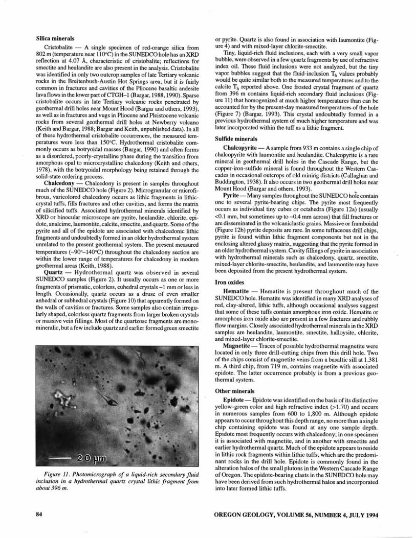
This study was undertaken primarily to obtain fluid inclusion homogenization temperature (Th) data, using a Linkam1 THM 600 heating/freezing stage and TMS 90 controller, from the lower half of the SUNEDCO 58-28 drill hole in order to determine how past temperatures compare with the present measured temperature proftle shown in Figure 2. Some hydrothermal quartz was observed, but
IAny use of trade, product, or firm fUlmes in this paper isfor descriptive purposes only and does not imply endorsement by the U.S. Government.
76
descriptions of the hydrothermal alteration were given in Conrey and Sherrod (1988) and Keith (1988). In the present investigation, about 42 percent (335) of the drill-hole samples was examined, and only a few previously unidentified hydrothermal minerals were recognized, mostly from XRD analyses. In the drill cuttings studied, several hydrothermal zeolite minerals and clay minerals were identified; other hydrothermal minerals include calcite, siderite, cristobalite, chalcedony, quartz, chalcopyrite, pyrite, epidote, anhydrite, magnetite, and iron oxide (Figure 2).
In addition to showing previously formed crystals of primary minerals and fragments of volcanic rocks, many of the tuff samples contain small lithic grains composed of hydrothermal chalcedony (± epidote) or grains with tiny pyrite crystals. This chalcedony and pyrite is obviously from a fossil hydrothermal system, but it is included in Figure 2 because at least some of it undoubtedly formed from geothermal activity that postdates the lithic tuffs. The very small grain size of other drill cuttings precludes distinguishing between minerals from possible late Tertiary fossil hydrothermal systems and those from subsequent hydrothermal systems, including the present active one.
OREGON GEOLOGY, VOLUME 56, NUMBER 4, JULY 1994
Zeolite minerals
Seven zeolite minerals (analcime, epistilbite, heulandite, laumontite, mordenite. scolecite, and stilbite/stellerite) have been idcntified in dr ill cuttings from the SUNEDCO 58-28 drill hole; laumontite and heulandite occur most frequently (Figure 2). Late Tertiary outcrops in the Breitenbush-Austin Hot Springs area contain many of these same hydrothermal zeolite minerals plus several additional zeolites. Formation temperatures for several hydrothermal zeolite minerals generally are thought to be about the same as the temperatures reported in studies of modern geothermal areas (summarized in Figure 2 of Keith, 1988). However, because of the Tertiary age of the rocks in the SUNEDCO 58-28 drill hole (Conrey and Sherrod, 1988), it is emphasized that favorable comparisons between measured temperatures at which zeolite minerals occur in th is drill hole and the published formation temperatures is not unequivocal cvidence that the minerals actually formed in the present thermal regime.
Analcime, Nal,(A ll ,Sin0 9') - 16H202- Analcime. in association with heulandite, laumontite, smectite(?), and halloysite, was identified in XRD analyses of several small greenish si liceous-appearing grains, light-gray lithic tuff fragments, and composite zeolite chips at 716-780 m. Analcime (plus laumontite, heulandite, and smectite) was found in two altered lithic tuff samples at 900 m. In addition. a single hornblende andesite sample from 1.787 III contains two isotropic. colorless crystal frag ments with a refractive inde;o:. of - 1.49 that probably are analcime; laumonti te, calcite, chalcedony. pyri te, chlorite, and epidote(?) also are present in this sample.
Several outcrops of Oligocene and lower Miocene volcanic and volcaniclastic rocks in the Breitenbush-Austin Hot Springs area contain colorless . euhedral, trapezohedral analcime crystals lining vugs and fractures. An average electron microprobe analysis of one of these samples shows that the mineral is nearly a pure analcime containing essentially Na as the e;o:.changeable cation (Table I ). Electron microprobe analyses of analcime from -744-m depth in the SUNEDCO 58-28 drill hole also contain Na as the principal exchangeable cation. Some deviation from the stoichiometric formula g iven above is present in both outcrop and drillhole analyses, but the balance errors for all analyses are within acceptable limits for zeolite minerals (Passaglia. 1970). These analyses indicate that the mineral is a nearly pure end member of the analcime-wairakite solid-solution series. Colorless, euhedral analcime crystals also line fractures and vesicles in drill core from geothermal drill hole CTG H-l.located about 14 km northeast of theoSUNEDCO 58-28 dri ll hole (Figure 1); EDS semiquantitative chemical analyses of this analcime show that sign ificant Ca is present in addition to Na, and the mineral is not a pure analcime end member (Balgar. 1990).
Analcime is a common mineral in geothermal areas, where, according to Kpsakabe and others (1981). its formation appears to be favored by increasing the fluid pH and Na+ concentration. In Iceland geothermal areas, analcime forms over a wide temperature rangeof about 70"C to ncar 3000C (Kristmannsd6nir and Tomasson, 1978). If analcime in the SUNEDCO 58-28 drill hole crystallized under presellt conditions, measured temperatures (-110"-130"C) indicate that the formation temperature was Ilear the lower end of the Icelandic temperature range.
Epistilbite, Ca)(AI,Si180 48) - 16H20 - An XRD analysis of white zeolite grains from the basaltic sill at 1.411 m contains reflections for cpistilbite and quartz. Epislilbite is not a rare mineral, but it has not been frequen tly reported in the Oregon Cascade Range. Bargar and others (1993) identified epistilbite ill a few geothermal test drill holes and one outcrop in Tertiary volcanic rocks of the Mount Hood area. Electron microprobe analyses of the
2Slciciziomc/ric formulas after Gou.ardi and Galli (/985).
OREGON GEOLOGY, VOLUME 56, NUMBER 4, J ULY 1994
Mount Hood epistilbite indicate that it is lower in Si and higher in Al and Ca than the stoichiometric formula. XRD analyses of samples from a few Tertiary outcrops in the Breitenbush-Austin Hot Springs area also contain reflections for epistilbite (Bargar, unpublished data).
Kristmansd6t1ir and Tomasson (1978) report that epistilbite in Iceland geothermal arcas occurs at measured temperatures ranging from 80" to 170"C. The single occurrence of epistilbite in the SUNEDCO 58-28 drill hole was at a depth where the present-day temperature is near 120"C (Figure 2); thus it could be compatible with current thermal conditions.
Heulandite, (Na,K)Ca4(AI~i270n) - 24H20 - Heulandite was identified by XRD from numerous samples throughout the middle portion of the drill hole (Figure 2). Many tuff grains contain heulandite that probably formed due to alteration of glass. Heulandite also occurs as open-space vesicle and micro fracture fillings, where it frequentl y has a salmon to orange color. Other associated minerals identified in the XRD analyses are analcime, laumontite. smectite, mixed-layer chlorite-smC(;tite. chlorite, celadonite, cristobalite. pyrite. chalcopyrite. and iron oxide. Only a few samples contained euhedral heulandite crystals as shown in Figure 3.
Electron microprobe analyses of one heulandite specimen from 939 m in the drill hole showed that it is Ca-rich heulandite (Table I) rather than Na+K-rich clinoptilolite. This identification was confirmed by heating eight of the samples to 450"C for 24 h (Mumpton . 1960). After heating. the XRD020 reflections for heulandite at -9 "disappeared. One sample appeared to have retained a very low XRD peak at - 8.6 A. indicative of intermediate heulandite (Alietli, 1972). Both heulandite and intermediate heulandite have been identified from Tertiaryoutcrop samp[es in the Breitenbush-Austin Hot Springs area (Bargar. unpublished data). An average microprobe analysis for one late Tertiary heulandite specimen is given in Table I; the analysis shows that the mineral consists almost entirely ofCa, AI. and Si, and is closer to the stoichiometric formula than are the analyses for heulandite from the SUNEDCO hole. Cation balance errors for all of the analyses fall within acceptable limits (Passaglia. 1970).
Figure 3. Scanning electron micrograph of randomly orienJed, tabular to blocky, ellhedral !lel/landile crystals from ahoul 77/ m.
77
Both heulandite and dinoptilolite were identified from vesicles_ frM:tures. and between breccia fragments in late Tertiary basaltic drill-core samples from nearby geothermal well CTGH- I (Bargar. 1988, 1990). The measured temperatures at the depths where heulandite in the SUNEOCO hole occurs range from 800-l30·C. These temperatures are within the range «700 to - 170' C) for heulandile in Iceland geothermal areas (Kristmansd6ttir and T6masson . 1978). In contrast, clinoptilolite and heu1andite occur al significantly lower temperatures (_300_96°C) in the CTGH-l dri ll hole (Bargar, 1990).
Laumontite, Ca4(A lsS il '0~) • 16H10 - Soft. milky-while laumontite was seen in most samples studied between 768 m and 1,98 1 m in Ihe SUNEDCO hole (Figure 2). Some samples from a depth below 2,000 m conlain a few grains of laumontite that might have sloughed from higher in the dri ll hole. Laumontite is readily dehydrated to form the minerallconhardite. which is designated as "only a variety" of laumontite (Gollardi and Gall i, 1985). While lconhardi te may occur in the drill -cutting samples from this drill hole. no attempt was made to distinguish between the two minerals, and only the name " laumontite" is used in this report. The presence of laumontite in whole-rock XR D analyses of severaltufr samples suggesls that some occurrences may have formed due to alteration of glass fragments or matr ix. However, most laumontite occurs as euhedral crystals that formed in open spaces of fractures and vugs and between lithic fragmen ls (Figure 4). Olher hydTOl:hermal minerals ide ntified in association with laumonti te in the drill hole samples are analcime. heulandite. calci te, siderite. quartz, pyrite,
Figure 4. Scanning electron micrograph offrocfllred to broken Imunontite (1.,) crystals in USsocialion with earlier. euhedrul qm:/Tfz (Q) crystalsfrom atxmll.454 m . See also Figure 8.
Table I . Electron microprobe (lnalyses of zeolite minerals from the SUNEDCO 58-28 drill hole and OIl/CropS in the Breitenbush-Al4stin HOI Springs (lrea. Reponed OlltCrop lInlllyses (Ire avemges of5 analyses. - = not (lnalyzed. Bal. error is detemrined by me/hod of Prusaglia (1970). (Contimled on next page)
Minerai Ana lflme Heulandite [.aumlllltite
SO COL- SOOGF. SUNt:OCO Samplena. SUN F.OCO 58--28 2440 2040A SUN EOCOS&-18 3080 lO76F 58-1.8 4230 Analysis nil. I I 3 I , 3 • , I 2
chalcopyrite, hematite, smectite, celadonite, and mixed-layer chlorite-smectite. SEM studies indicate that laumontite formed later than quartz, mixed-layer chlorite-smectite, and siderite and was deposited earlier than smectite and heulandite.
Laumontite is a very common hydrothermal mineral and has been found over a wide temperature range (43°-230°C) (Kristmannsd6ttir and T6masson, 1978; McCulloh and others, 1981) in many geothermal areas. The present-day temperature range at which laumontite was identified in the SUNEDCO hole is very narrow (110°-130°C).
Electron microprobe analyses of laumontite from about 1,289 m in the SUNEDCO hole showed that the mineral contains only small amounts of elements other than Ca, AI, and Si (Table 1). During related field studies of the Breitenbush-Austin Hot Springs area, laumontite was collected from several late Tertiary outcrops. Electron microprobe analyses of laumontite from two of the widely separated outcrops in this area (Table 1) are very similar to the SUNEDCO 58--28 analyses. Both drill-hole and outcrop analyses of laumontite do not quite match the stoichiometric formula given above; however, cation balance errors for all of the analyses are within acceptable limits (Passaglia, 1970).
Mordenite, Na3KCa2(AlsSi40096) • 28H20 - XRD analyses of a few milky-white siliceous fragments from depths of 518 m and 579 m contain reflections for mordenite. These two samples are the only oneS in which mordenite was identified; however, mordenite occurs in several late Tertiary outcrops in the Breitenbush-Austin Hot Springs area and is common in drill core from the lower part of the nearby drill hole CTGH-l (Bargar, 1988, 1990). In these occurrences, mordenite is a late hydrothermal
mineral deposited in open spaces of fractures and vugs together with heulandite and chalcedony.
In SUNEDCO 58--28, mordenite was found where the measured temperature is -80°C. In Icelandic geothermal areas, mordenite is found over a temperature range of 80°-230°C (Kristmansd6ttir and T6masson, 1978); however, in drill hole CTGH-l, mordenite was identified at depths where present-day temperatures are 60°-96°C.
Scolecite, Cag(AI16Si240g0) • 24H20 - Two samples at 1,280 m and 1,289 m contain a few grains of hard, white, fibrous scolecite; laumontite and smectite occur in the same samples. Scolecite also has been found in a few late Tertiary outcrops in the BreitenbushAustin Hot Springs area. The mineral is identified as scolecite (Ca-rich) because it exhibits inclined optical extinction; structurally similar mesolite (Na+Ca) and natrolite (Na-rich) both have parallel extinction. Electron microprobe analyses of scolecite from the Mount Hood area (Bargar and others, 1993) are consistent with the stoichiometric formula given above.
Ca-rich scolecite was reported from drill hole CTGH-l (temperature is -30°-4Q°C) (Bargar, 1990); however, subsequent electron microprobe analyses (Bargar, unpUblished data) show that the mineral contains significant N a and is meso lite. The measured temperature at the depth where scolecite was found in the SUNEDCO hole is about 120°C. From their studies ofIcelandic geothermal areas, Kristrnannsd6ttir and T6masson (1978) reported scolecite (and mesolite) only from drill holes in low-temperature areas at <70°-100°C.
in two zones: 844--1,009 m and 1.405-1.454 m (Figure 2). XRD analyses indicate that the mineral is either stilbite or structurally similar stellerite between which a complete solid-solution series exists (Passaglia and others, 1978). A few specimens are associated with hydrothermal quartz, laumontite. or dark-green clay (both smectite and mixed-layer chlorite-smectite). Occasional cuttings show thin veins filled with late, colorless, tabular. broken stilbite/stellerite crystals oriented perpendicular to earlier dark-green clay-lined margins.
Electron microprobe analyses of several stilbite/stellerite crystals from about 1,006 m are given in Table I along with stilbite/stellerite from late Tertiary outcrops in the Breitenbush-Austin Hot Springs area. The analyses listed in Table I show that ea is the dominant cation. suggestive of stellerite rather than stilbite, but these two very similar minerals are distinguishable with confidence only by single-crystal XRD analysis (R.C. Erd, written communication, 1992), which was not attempted for any of these stilbite/stellerite specimens.
Stilbite/stellerite occurs in the SUNEOCO hole at present-day temperatures of about 110°C to 120"C. In Iceland. stilbitc is found at 70°-170°C (Kristmannsd6ttir and T6masson, 1978).
Carbonate minerals
Cald te- Samples throughout the SUNEDCO hole contain soft, white, cloudy, or colorless calcite (Figure 2). II usually ()C(:urs as monomineralic crystal fragments; complete crystals or crystal clusters (Figure 5) are uncommon. Calcite is seldom associated wi th other hydrothermal minerals. only rarely with laumontite. Calcite commonly fi lls fractures, vesicles, and cavities between tuff breccia fragments in the Oligocene and lowcr Miocene rocks of the Breitenbush-Austin Hot Springs area. and presumably its occurrence is similar in the SUNEDCO hole. In contrast. dri ll hole CTGH-1 contains only traces of calcite, mainly in early Pliocene lava flows (Bargar, 1988,1990).
Liquid-rich secondary(?) fluid inclusions (Figure 6) were observed in several colorless to cloudy calcite crystal fragments. These fragments were too small and fragile to polish, although it was
Figure 5. Scanning electron micrograph of twinned(?) caldte crystals from about 1,787 m.
8.
•
20 •
Figure 6. PhOlomicrog mph of liquid-rich, secondary fluid inclusions in an anpolished caldte cleavage chip from abow 1,470 m.
possible to obtain some fluid inclusion data. No melt ing-point temperatures (T m) were obtained because. when the fluid inclusions were frozen, the tiny vapor bubbles disappeared and reappeared at temperatures as high as + 3.9°C, indicating that the fluid inclusions were metastable and did not yield reliable salinity data (Roedder, 1984). However, 42 fluid inclusions in calcite from four sample depths yielded homogenization temperatures (Til) ranging from 114" to 173°C (Table 2). Comparison of the fluid-inclusion Til values with the measured temperatures in the SUNEDCO hole (Blackwell and others, 1986) in Figure 7 shows that (I) maximum fluid-inclusion Til values record past temperatures that were at least as high as 1520C (one measurement is 173°C) and (2) minimum Til measurements plot very close to the present-day temperatures at several depths within the drill hole. Close correspondence between minimum fluid-inclusion Til values and present measured temperatures within other geothcnnal drill holes led Taguchi and others (1984) to conclude that minimum fluid-inclusion Til can be used to estimate present-day temperatures within dri ll holes. Thus. fluid inclusions in calcite from this drill hole indicate that at least some of the trapped fluids are related to the present geothermal system. It may also be concluded that the geothermal system has cooled by about 35DC.
Siderite - Orange siderite was identified in five samples from 244 to 305 m, 796 m, and 2,280 m. SEM analysis of an open-space (fracture?) filling at 796 m (Figure 8) shows that colloform clusters of rhombic siderite crystals formed earlier than laumontite and smectite; an EDS analysis of this deposit detected the presence of Fe, Ca, and Mn. Siderite has not been foun d in outcrops examined in this area, but it occurs in a few drill-hole and outcrop samples in the Mount Hood area (Bargar and others, 1993) and in several geothermal core holes at Newberry volcano (Bargar and Keith, unpublished data). In U.S. Geological Survey (USGS) drill hole Newberry 2, siderite is found at temperatures ranging from 60" to 130"C (Keith and Bargar, 1988). Siderite occurs at present-day temperatures of 40D_I40DC in the SUNEDCO hole.
Clay minerals
Ten clay minerals were identified in theSUNEDCOsamples. The distribution of clay minerals shown in Figure 2 is based on XRD analyses of 124 clay-bearing specimens.
• Multiple calibration measurements. using fynthetic fluid inclusions (Bodnar and Stemer, 1984) and chemical compoonds with known mehing-point temperaturef recommended by Roedder (1984). fuggest that the Tb measurements should be accurate to beller than ±2.0'C and that the T m valuef fhould be accurate to within ±O.2·C .. Positive Tm values indicate metastability, and the fluid inclusions cannot be used for salinity calculations (Roedder, 1984). **. Salinity values are not corrected for C02-
0 ... .
r- ~
r-
<000 f- -
~ S8?C ............ \ -z I;: .&k -0
~ \ , .L~
2000 f- 1 -, , , , , ~ rul.I'-1o
" I
0 100 200 300
TEMPERATURE ("C)
o Hydrothermal Quartz . Anhydrite· [J Cillcite 0 Primilry Quartz
Figure 7. Depth verSIlS homogenization temperatures for fluid inclusions in hydrothermal quartz, calcite, (md anhydrite crystals, and primary quartz phenocrysts from drill hole SUNEDCO 58-28. Dolle(1 cllrve labeled SBPC is (/ theoretical reference boiling poinl cllrve for pure water drawn to the ground sllrface. Solid curve shuws a measured-temperature profile using data in Blackwell and others (1986); the continuing dtlshed fine is an estimate of temperatures in the luwer part of the drill hole based on a bollom-hole temperature oj - 141QC given by A.F. Waibel (unpublished data, 1982). Individllal fh measurements, shown by different patterned boxes keyed to type of mineral analyzed, are plolled al 5Q C intervals as histograms with sample depth /.IS II baseline.
OREGON GEOLOGY, VOLUME 56, NUMBER 4. JULY 1994
Figure 8. Scalllling electron micrograph showing spherical clusters oj rhombic siderite (S) crystals along with laler euhedral laumonlite (L) prismatic crystals and smectite (Sm) from abom 796 m.
Sepiolite(?) - In a hornblende andesite lava flow at 1,762-1,780 m, a few soft, white, rounded chips of a clayey mineral that has a fibrous habit in SEM are present. The chips show a single XRD reflection at about 12.6 A thai remains unchanged fo llowing glycolation; however, no reflections are present after heating al 4OO"C for I h. These analyses suggest that the mineral is sepiolite (Starkey and others, 1984). Carame1-colored clay, also tentatively identified as sepiolile, occurs in cuuings from one geothermal drill hole in the Mount Hood area (Bargar and olhers. 1993). Hydrothermal sepiolite ha~ been reported elsewhere in veins of mafic igneous rock, where it occurs as an alteration prodU(;t of magnesium carbonates or silicates (Phillips and Griffen, 1981 ). Sepiolite formation by alteration of either of these two mineral groups would not appear compalible wi th conditions within either the Mount Hood or the SUNEDCO drill holes. Several oflheMounl Hood drill holes contain abundant foreign materials, including drilling mud, added to facilitate drilling. Sepiolite is commonly used in drilling fluids for geothermal drill holes because
81
it does not flocculate at high temperatures (Greene and Goodman. 1982). Although the SUNEDCO cuttings studied were thoroughly washed, and foreign material was only occasionally observed, it seems likely thai the sepiolite was introduced during drilling.
Celadonite - In field studies of hydrothennai alteration in the Breitenbush-Austin Hot Springs area, only one celadonite-bearing specimen was found in outcrops of late Tertiary rocks. However, chips of blue-green altered lithic tuff or clay were observed throughout much of the middle portion of the SUNEDCO hole at depths of 777-1,521 m. Celadonite. identified by XRD along with associated heulandite, smectite, laumontite. and milled-layer chlorite-smectite. occurs aI depths where present-day temperatures are I 10"-1 3O"C. In the lower part of the CTGH- I drill hole. blue'green, clayey celadonite and tiny micaceous books of celadonite were found at measured temperatures of 65"-96"C (Bargar, 1988. 1990).
Smectite - Most samples above about 1.920 m contain vari·
82
Left and above:
Figure 9. Scanning electron micrographs showing iron-rich platy smectite crystals thatformed (a) in random orienlation (-7/6 m), (b) as radiating elI/siers of crystals (-1,411 m), or (c) as fracture or vein fillings oriented perpendicular 10 rhe fracture surface (-1.411 m).
colored (predominantly reddish and greenish) smectite that formed by precipitation from hydrothermal solutions in open spaces of fractures and cavities during alteration of glass or mafic minerals in lithic-crystal tuffs. Smectite shows a major XRD reflection at - 15 A that shifts to - 17 A following exposure to ethylcne glycol vapors at 6O"C for I h; heating to 550DC for 0.5 h results in collapse to - 10 A. Many of these clays are poorly crystalline, which results in low, broad. asymmetrical XRD ret1ections. Associated hydro· thermal minerals are pyrite, halloysite, chalcedony, kaolinite, heulandite, hematite, criSlObalite. celadonite. laumontite. scolecite. calcite. and chlorite. The green color of many of the clays in this drill hole suggests that iron-rich nontronite probably is the prcvalent smectite-group mineral; this is confinned by semiquantitative EDS analyses indicating that Fe is the dominant cation present. The smectite commonly occurs as randomly oriented platy crystals (Figure 9a). However. it occasionally forms platy rosettes (Figure 9b) or vein fillings with plates oriented perpendicular to the vein margins (Figure 9c).
Mixed-layer chlorite-smectite - Mixed-layer chlorite-smectite was identified from the middle part of the SUNEDCO hole at 1.280--1,457 m. These medium· to dark-green clays have a strong (001) XRD reflection at-14.5 A and a weaker (0Q2)peakat -7.2 A. which. following ellposure to ethylene glycol vapors at 6O"C for 1 h. show slight expansion to - 15.0 A and - 7.3 A. respectively. According to the identification guidelines for mixed-layer clay minerals (Hower, 1981). mixed-layer chlorite·smectite appears to
be randomly interstratified and consists of - 80 percent chlori te. An
OREGON GEOWGY, VOLUME 56, NUMBER4. JULY 1994
SEM study of one mued-layer chlori te-smectite specimen from about 1,426 m shows random o rientation of the platy crystals and the presence of Si, AI, Fe, Ca, Mg, TI, and Mn in EDS. Several of the milled-layer chlori te-smectite drill chips are shiny or striated and appear to have originated in fractures. The mineral sometimes is associated with later laumontite, heulandite. or stilbite/stellerite. Other associated hydrothermal minerals identified in the XRD analyses are calcite. quartz, and celadonite.
This mixed-layer chlorite-smectite in the SUNEDCO holeoccurs where measured temperatures are I lOo-130'C. Similar mixed-layer chlorite-smectite was found near the bottoms of several geothennal drill holes at Newberry volcano at temperatures of l100- 265°C (Keith and Bargar. 1988).
C hlorite - A few specimens from three zones in the drill hole, 1,417- 1 ,472m, 1,753-1 ,911 m,and2,225-2,286m (Figure2).show broad, weak (001) XRD reflections at about 14.4 A and slightly stronger (002) reflections at about 7.1 A. For most specimens, the location of these reflections did not appear to change posi tion significantly following glycolation. and the mineral is identified as chlorite. However, some sl ight apparent shifts in the (001) peaks noted for a few specimens suggest that a small smectite component is also present. The only other associated hydrothennal minerals identified by XRD analysis are laumontite, calcite, illite, and heulandite. Chlorite occurs over a wide range of temperatures in modem geothennal areas (Hulen and Nielson, 1986). In the SUNEDCO hole, the chlorite occurs attcmperatures of 120°-140°C. In USGS Newberry 2 drill hole, the main chlorite zone occurs at temperatures between 120° and 265°C (Keith and Bargar, 1988).
Corrensite(?) - Five reddish lithic tuff samples from 1,800 to 1,950 m have a higher order reflect ion at about 25.3 A and a subordinate reflection near 12.2 A, which, after treatment with ethylene glycol vapors at 60°C for 1 h, shift to about 28.5 A and 13.5 A, respectively. Determination of the ell3ctlocations of these reflections is difficult because the peaks are mostly low, broad, and asymmetrical. Reflect ions for smectite and hematite are also present in some of the XRD analyses. For one of the samples containing smectite. heating t04000C for 0.5 h resulted in destruction of all the reflections ellcept for the - IO-A smectite peak. Although these XRD data do not correspond to minerals with higher order reflections such as corrensite (a regular interstratifi· cation of chlorite and vermiculite), todusite, or rectorite (Starkey and others, 1984), somewhat similar XRD data, with glycolated refl ections in the range of about 27 A to 31 A. were interpreted as an interstratification of corrensite and smectite by Inoue and others (19S4). Tomita and others (1969) also report an interstrat ified mineral (chlorite·montmorillonite with another mued·layer mineral?) having reflections at 26.8 A and 12.6 A that ellpand to 28.5 A and 13.4 A with ethylene glycol treatment; after heating at 5()(yC for 1 h only a 10-A reflection remained. The mineral referred to in this report as corrensite(?) may be a complex interstratification of corrensile and smectite o r possibly a mixture of other interstratified clay minerals.
Illite - Illite was identified by XRD analysis in samples from 1,426 m and in light-green clay chips and greenish clay.altered tuff fragments below 1,950 m. The majority of ill ite -1O.2-A reflections are low, broad, asymmetrical peaks that shift to 10.0 A following glycolation. Reflections slightly greater than 10 A may indicate the presence of a very small amount of interlayered smectite, but no indication of smectite was observed on diffractograms of glycolated samples. and the mineral is referred to here as ill ite. Other hydrothermal minerals' in the same XRD analyses are hematite, corrensi te(?), chlorite, calcite, and a serpentine·kaolinite group mineral . Illite in the SUNEDCO hole occurs at temperatures of 1200-1400C. Hulen and Nielson (1986) indicate that illite in modern geothermal areas occurs at temperatures as low as about 1200C and as high as 33~C.
OREGON GEOLOGY, VOLUME 56, NUMBER 4,JULY 1994
Serpentine.kaolinite group minerals - Scattered samples from the upper part of the drill hole, at depths 0'£ 274.-747 m (Figure 2) contain clay·altered tuff fragments or chips of red, gray, or green clay that have XRD reflections for halloysite and kaolin ite. Most of these specimens have low. broad, asymmetrical (001) reflections at - 7.2 A, characteristic of halloysite (Brindley. 1980). However. a few specimens are less disordered and have (002) reflections near 3.57 A in addition to the (ool) reflections that are much sharper; the mineral probably is kaolin ite. The XRD patterns show no change with glycolation, but the reflections are destroyed by heating to 550"C for 0.5 h. Other associated hydrothennal minerals identified on these X-ray diffractograms are smectite, hematite, analcime, and heulandite. Both kaolinite and halloysite were identified during studies of hydrother· mal alteration near Mount Hood, where they probably fonned by fumarolic al teration close to the summit of the mountain (Bargar and others, 1993). Thesekaolin minerals in the SUNEDCO holeare found at temperatures between about 40"C and IIO"C, which according to Hulen and Nielson (1986) is the appropriate range for kaolinite.
Another serpentine·kaolinite group mineral identified in many samples near the bottom o f the drill hole below 2,164 m (temperature - 140°C) is berthierine(?). Greenish metamorphosed tu ff frag ments in which this mineral occurs show fairly sharp (001) and (002) XRD reflections at about 7 . 1 A and 3.54 A, respectively, and semiqualitative chemical analysis by EDS on the SEM shows only Fe, AI. and Si. Other associated hydrothermal minerals identified in the same X·ray analyses are illite. siderite, calcite, and smectite. A mineral with similar charac teris tics was found in one specimen from a deserted mining area near Mount Hood (Bargar and others, 1993). An analogous serpentine-kaolinite group mineral referred to as septechlorite (no longer an accepted mineral name) was reported from USGS research drilling in the Mud Volcano area of Yellowstone National Park at temperatures of 11 0 o- 190'C (Bargar and Muffler, 1982).
Figure 10. Scanning electron micrograph of drusy subhedral quartz crystals that formed in a fracture or cavity filling at about 802 m.
83
Silica minera ls
Cristobalite - A single specimen o f red-orange sil ica from 802 m (temperalUre near I IOOC) in the SUNEDCO hole has anXRD renection at 4.07 A. characteristic o f cristobalite; reflections for smectite and heulandite are also present in the analysis. Cristobalite was identi fied in only two outcrop samples of late Tertiary volcanic rocks in the Breitenbush-Austin Hot Springs area. but it is fairly oommon in fractures and cavi ties of the Plicx:ene basaltic andesite lava nows in the)owerpart ofCfGH-1 (Bargar, 19S8. I990).Sparse crislObalite occurs in late Tert iary volcanic rocks penelrated by geothermal dril l holes near Mount Hood (Bargar and others, 1993). as well as in fractures and vugs in Pliocene and Pleistocene volcanic rocks from several geothermal dri ll holes at Newbeny volcano (Keith and Bargar. 1988; Bargar and Keith, unpublished data). In all o f these hydrothermal cristobali te occurrences. the measured temperatures were less than 1500C. Hydrothermal cristobalite commonly occurs as botryoidal masses (Bargar. 1990) and o ft en forms as a disordered, poorly·crys talline phase during the transition from amorphous opal 10 microcrystal line chalcedony (Ke ith and others, 1978), with the botryoidal morpho logy being retained through the solid·state ordering process.
C halcedony - Chalcedony is present in samples throughout much o f the SUNEDCO ho le (Figure 2). Microgranular or microfi brous, varicolored chalcedony occurs as lithic fragments in lithiccrystal tuffs. fills fractures and other cavities. and forms the matrix of si licified tuffs. Associated hydrOlhermal minerals identified by XRD or binocular microscope are pyrite. heulandite. chlorite, epidote, analcime. laumontite, calcite. smectite, andquaru.. Someofthe pyrite and all of the epidote are associa ted with chalccdonic lithic fragments and undoubtedly formed in an older hydrothermal system unrelated 10 the present geothermal system. The present measured temperatures (-9O"-14O"C) throughout the chalcedony section are within the lower range of temperatures for chalcedony in modem geothermal areas (Ke ith, 1988).
Quartz - Hydro the rma l quanz was o bserved in several SUNEDCO samples (Figure 2). It usually occurs as one or more fragments of prismatic, colorless, euhedral crystals - I mm or less in length. Occasionally. quartz occurs as a druse of even smaller anhedral or subhedral crystals (Figure 10) that apparently formed on the walls of cavities or fractures. Some samples also contain irregularly shaped, colorless quartz fragments from larger broken crystals or massive vein fillings. Most of the quartzose fragments are monomineralic, but a few include quartz and earlier formed green smectite
Figure II . Photomicrograph of a liquid-rich secondary fluid inclusion in a hydrothermal qllOrtz crystal lithic fragment from aboul396 m.
84
or pyrite. Quanz is also found in association with laumontite (Figure 4) and with mixed. layer chlorite-smectite.
Tiny. liquid· rich nuid inclusions. each with a very small vapor bobble, were observed in a few quartz fTagments by use of refractive index oil. These nuid inclusions were not analyzed, but the tiny vapor bubbles suggest that the nuid·inclusion Tb values probably would bequite similar both to the measured temperatures and 10 the calcite Th reported above. One frosted crystal fragment of quanz from 396 m contains liquid-rich secondary n uid inclusions (Fig. ure II) that homogenized at much higher temperatures than can be accounted for by the present-day measured temperatures of the hole (Figure 7) (Bargar, 1993). This crystal undoubtedly formed in a previous hydrothermal system of much higher temperature and was later incol"jXlrated within the tuff as a lithic fragment .
Sulfide minera ls
Chalcopyrite - A sample from 933 m contains a single chip of chalcopyrite with laumo ntite and heulandite. C halcopyrite is a rare mineral in geothermal drill holes in the Cascade Range, but the copper-iron·sulfide minera l is found throughout the Western Cascades in occasional o utcrops o f o ld minirig districts (Callaghan and Buddington, 1938). It also occurs in two geothermal drill holes near Mount Hood (Bargar and OIhers. 1993).
Pyrite - Many samples throughout the SUNEDCO hoie contain one to several pyrite-bearing chips. The pyrite most frequently occurs as individual tiny cubes or octahedra (Figure 12a) (usually <0.1 mm. but sometimes up to -0.4 mm across) that fill fractures or are disseminated in the volcaniclastic grains. Massive IT framboidal (Figure 12b) pyrite deposits are rare. In some tuffaceous drill chips. pyrite is found within lithic fragment components but not in the enclosing altered glassy matrix, suggesting that the pyrite formed in an older hydrothermal system. Cavity fi llings of pyrite in association with hydrothermal minerals such as chalcedony, quartz, smectite. mixed· layer chlorite· smectite. heulandite, and laumontite may have been deposited from the present hydrOlhermal system.
Iron oxides
Hematite - Hematite is present througho ut much of the SUNEDCO hole. Hematite was identified in many XRD analyses o f red, clay-altered, lithic tuffs. although occasional analyses suggest that some of these tuffs contain amorphous iron oxide. Hematite or amorphous iron oxide also are present in a few fractures and rubbly flow margins. Closely associated hydrothermal minerals in the XRD samples are heulandite. laumontite. smectite . halloysite , chlorite. and mixed-layer chlorite-smectite.
Magnetite - Traces of possible hydrothermal magnetite were located in o nly three drill -cutting chips from this drill hole. Two of the chips consist of magnetite veins from a basaltic sill at 1.381 m. A th ird chip. from 7 19 m, contains magnetite wi th associated epidote. The latter occurrence probably is from a previous geothermal system .
Other minerals
Epidote - Epidote was identified on the basis of its distinctive yellow-green color and high refractive index (> 1.70) and occurs in numerous samples from 600 to 1,800 m. Although epidote appears to occur throughout this depth range. no more than a single chip containing epidote was found at anyone sample depth. Epidote most frequently occurs with chalcedony; in one specimen it is associated with magnetite. and in another w ith smectite and earlier hydrothermal quartz. Much o f theepidote appears to res ide in lith ic rock fragments within lithic tuffs, which are the predominant rocks in the dri ll hole. Epidote is commonly found in the alteration halos of the small plutons in the Western Cascade Range of Oregon. Theepidote·bearing clasts in the SUNEDCO hole may have been derived from such hydrothermal halos and incorporated into later formed lithic tuffs.
OREGON GEOLOGY, VOLUME 56, NUMBER 4, JULY 1994
Figure 12. SeaMing electron micrographs showing (aJ oe· tahedral pyrite crystals and later dusting of smectite fram about J.37 J m, and (b)framboidal clusters of pyrite crystals and casts of the spherical crystal clUSlers of pyrite in later smectile from about 1.423 m.
OREGON GEOLOGY. VOLUME 56, NUMBER 4, JULY 1994
Anhydrite - A few small, soft, tabular, colorless cleavage chips of anhydrite were identified from two narrow zones (1,792-1,817 m, and 1,908-1,920 m) in the lower pan of the drill hole. Some of the unpolished anhydrite chips contain liquid-rich secondary(?) fl uid inclusions with very small vapor bubbles (Figure 13). The Th for 22 of these nuid inclusions in five sample chips (Table 2) range from 123e to 133°C, which is very close to the temperature-depth curve given in Blackwell and others (1986) (Figure 7). However, three primary(?) nuid inclusions from another sample chip have Th of 152"C, 179°C, and 191 ·C, which indicates that this anhydrite crystal may have formed at significantly higher temperatures. Melting point temperatures for five of the anhydrite fluid inclusions are quite variable and are as high as + 1.5°C. The fluid inclusions appear 10 be metastable (Roedder. 1984) .
•
•
• •
Figure 13. PhOiomicrograph of liquid-rich secondary fluid inclusions in an anhydrite cleavage chip from aboul/,9/0 m.
Titanife(?) - A single grain from 1,759 m contains tiny wedgeor diamond-shaped crystals of titanite(?) (Figure 14) that consist of Ca. 11. Si, and Al in EDS. Other hydrothermal minerals in the mixture of hornblende andesite and crystal-lithic tuff drill chips are laumonli te. calcite. smectite and hematite. Authigenic titanite has been reported from New Zealand (Boles and Coombs, 1977) and the Cerro Prieto geothennal field of Mexico (Schiffman and others, 1985). Schiffman and others (1985) indicate that Al and Fe3+ substitute for 11, and the titanite they described is very AI-rich. Aluminum- and iron-rich titanite was tentatively identified in drill cunings from a geothennal drill hole near Mount Hood (Bargar and others, 1993). Schiffman and others (1985) indicated that the Cerro Prieto titanite probably formed at temperatures below 150·C, which is similarto the conditiOfls for the occurrence of titanite(?) in the SUNEDCO hole.
Garnet(?) - Two drill chips from a lith ic tuff unit at 1,369 m contain anhedral to subhedral crystals of a yellow-orange mineral containing Ca, Fe, ± AI, and Si in EDS. Crystal morphology (Figure 15) and the semiquantitative chemislry suggest that the mineral might be andradite garnet. Associated hydrothermal minerals in these chips are calcite, pyrite, and laumontite; celadonite and mixed-layer chlorite-smectite were also identified from this sam ple depth. GarnelS are reported from several active geothermal systems where temperatures exceed 3OO"C (Bird and olhers, 1984). If the mineral is garnet, it most likely formed in an older, higher temperature hydrothermal system and was later incorporated inlO the lithic tuff unit.
85
Figure 14. Scanning electron micrograph of subhedral titanite(?) crystals from aboul 1,759 m. Some of the titanite(?) crystals appear to be wedge slulped.
DISCUSSION The 2,457-m-deep SUNEDCO 58-28 drill hole penetrated late
Tertiary volcanic and volcaniclastic rocks, as well as a few minor intrusions. Drill cUllings from this geothermal exploration hole are altered to zeolites (analcime, epistilbite, heulandite, laumontite. mordenite, scolecite, and stilbite/stellerite), carbonates (calcite and siderite), clays (smectite, celadonite, mixed-layer chlorite-smectite, chlorite, serpentine-kaolinite group minerals. corrensite[1], and sepiolite]?!), silica minerals (cristobalite. chalcedony, and quartz), pyrite, iron oxide, and trace amounts of a few other hydrothermal minerals including epidote, chalcopyrite, anhydrite, magnetite, garnet(?), and titaniter?). Glassy material in the tuffs is altered tozeolites and clays; these minerals along with other hydrothermal minerals also appear to have formed in fractures and cavities throughout most of the drill hole. Hematite and amorphous iron oxide occur as open space deposits and alterat ion of mafic minerals.
A nOfle<J:uilibrium temperature of -141 °C (A.F. Waibel, unpublished data, 1982) was measured at the bottom of the drill hole, although the actual bottom-hole temperature may have been near 150"C (Blackwell and Baker, 1988). Homogenization temperatures (Th)for secondary liquid-rich fluid inclusions in calcite, and anhydrite suggest that these fluid inclusions may have formed in the present-day geothermal system, because the minimum Th values are nearly coincident with the measured temperatures at the fluid-inclusion sample depths (Taguchi and others, 1984). The fluid inclusions in calcite and anhydrite have mostly (only a single exception) maximum Th values of less than the 174°C geothermometer temperature that lngebritsen and others (1989) reponed for the aquifer supplying the nearby Breitenbush Hot Springs dilute Na-CI waters (Mariner and others, 1993). The T h measurements for fluid inclu-
86
Figure 15. Scanning electron micrograph of sllbhedral garnet( ? ) crystalsfrom about 1,369 m.
sions in primary quartz crystals from near the bottom of the drill hole range from near the estimated temperature at the sample depth to as much as 42"C higher than the geothermometer temperature for the Breitenbush Hot Springs water. This suggests that these fluid inclusions trapped water from a different aquifer than the one fceding the thermal springs. Also, limited T rn measurements for the near-bottom Iluid inclusions indicate that the trapped water is from an aquifer that has a significantly greater salinity than Breitenbush Hot Springs.
Except for some mineral paragenesis observations in SEM. the se<J:uence of mineral formation is difficult to determine from the dri ll -cutting samples. Although trace amounts of epidote are widespread in the cuttings, which might suggest temperatures of at leasl 230"C (Seki, 1972), petrographic observations indicate that the epidote, along with several other hydrothermal minerals including garnet(?), some pyrite, quartz, and chalcedony, is confined 10 lithic fragments in tuffs and tuffaceous sedimentary deposits and was incorporafed by fragmentat ion of older geothermal halos. It has previously been pointed out that someof the hydrothennal alteration minerals (especially epidOle) in the SUNEDCO 58-28 chips formed at higher temperatures than were measured in this drill hole (Keith, 1988). Other misleading picces of evidence for higher temperatures in this drill hole are (I) the presence of garnet(?), which forms at temperatures above 300°C (Bird and others, 1984), and (2) fluid inclusion Th values of 232°-274"C for a quartz fragment from the shallower part (396 m) of the drill hole.
CONCL USIONS Hydrothermal-mineralogy and fluid- inclusion studies of the
SUNEDCO 58-28 drill hole samples indicate that most of the alteration minerals probably formed in the present-day geothermal system. The majority of hydrothermal minerals precipitated from Na-CI water sim ilar to that of nearby Breitenbush Hot Springs. However, some hydrothermal chalcedony, quartz, pyrite. and, especially, epidote and garnet(?) formed from one or more older, higher temperature geothermal systems. These minerals occur in lithic rock fragments that were either eroded or broken up by explosive volcanic activity and later were incorporated into the tuffaceous units penetrated in the SUNEDCO drill hole. A change in clay mineralogy from smectite/celadonite to illite/serpentine-
O REGON GEOLOGY, VOLUM E 56, NUMBER 4, J ULY 1994
kaolinite along with slightly higher fluid-inclusion Th values and lowerT m values at about2,OOO m suggest that a second, more saline aquifer may be present near the bottom of the drill hole.
ACKNOWLEDGMENTS This study was aided by electron microprobe analyses provided
by P. Weston and scanning electron micrographs supplied by R.O. Oscarson. Special thanks goto A.F. Waibel. Columbia Geoscience. Hillsboro. Oregon, for making the SUNEDCO 58-28 drill hole samples available for this study. Reviews by R.A. Bailey and M.H. Beeson improved the manuscript and are gratefully acknowledged.
REFERENCES CITED Alietti. A .• 1972. Polymorphism and crystaJ-chemistry of heutandites and
clinoplilolites: American Mineralogist, v. 57, p. 1448-1462. Bargar, K.E .. 1988. :kcoodary mineralogy of core from geothennal drill hole
CTGH-I. Cascade Range. Oregon. in Sherrod. D.R .. ed .. Goology and geothennal resources of the Breitenbush.Austin Hot Springs area. Clack· amas and Marion Counties, Oregon: Oregon Depanment of Geology and Mineral [ndu"ries Open· File RefXlR 0-88-5. p. 39-45.
---1990. Hydrothermal alteration in geothermal drill holeC"rGH-I. High Cascade Range. Oregon: Oregon Geology. v. 52. no. 4. p. 75--81 .
--1993. Fluid-inclusion evidence for previous higher temperatures in the SUNEDCO 58-28 driU hole near Breitenbush Hot Springs, Oregon: Geothermal ResOUrtts CoUllCil Transactions. v. 17. p. 83-$9.
Bargar, K.E., Keith. T.E.C., and Beeson. M.H., 1993, Hydrothermal alteration in the MowlI Hood area, Oregon: U.S. Geological Survey Bulletin 2054, 70.
Bargar, K.E., and Muffler, LJ.P., 1982, Hydrothermal alteration in research drill hole Y-II from a vapor-dominaled geothermal system al Mud Vo[cano, Yello .... stone Nalion.al Park, Wyoming: Wyoming Geological Anocialion Annual Field Conference, 33rd, Mammoth IlotSprings, Wyoming, Guidebook. p. 139-152.
Bird. O.K .. Schiffman, P .. Elders. W.A .. Williams. A.E.. and McDowell. S.O .. 1984. Calc_silicate mineralization in active geothermal systems: Economic Geology, v. 79. p. 671~9S.
Blackwell. D.O., and Baker, S.L., 1983, Thermal analysis of the Austin and Breitenbush geotllennal systems, Western Cascades, Oregon, in Sherrod, D.R., ed .. Geology and geothermal resources of the Breitenbusli-Austin HOI Springs area, Oackamas and Marion Countie$. Oregon: Oregon Department of Geology and Mineral Industries Open·File Report 0-88-5. p. 47~2.
Black .... ell. D.O .. Black. G.L.. and Priest, G.R., 1986, Geothermal_gradient data for Oregon (1982-1984): Oregon Departmoot of Geology and Mineral Industries Open-File Report 0-86-2, 107 p.
Bodnar. RJ., and Sterner, S.M., 1984, Synthetic fluid inclusions in nalural quanz I; compositional types synthesized and applications to experimental geochemistry: Geochimica et Cosmochimica Acta, v. 48, p. 2659-2668.
Boles. J.R.. and Coombs. O.S., 1977 .Zeo ~te facies alteration of sandstones in the Soiithland Syncline, New Zealand: American Journal of Science, v. 277, p. 982-1012.
Brindley, G.W., 1980, Order·disorder in clay mineral structures, in Brindley, G.w.. and Brown. G .. eds .. Crystal structures of c lay minerals and their X-ray identification: Loodon, Mineralogical Society. Monograph 5, p. 125-195.
Callaghan, E., ~d Buddington, A.F., 1938, Metalliferoos mineral deposits of theCascadeRangein Oregon: US. Geological Survey Bulletin 893, 141 p.
Conrey, R.M., and Sherrod, D.R .. 1988. Stratigraphy of drill hOles and geocllemistry of surface rocks., Breitenbush HOI Springs IS-minute quadrangle, Cascade Range, Oregon, in Sherrod, DR, ed., Geology and geothermal resources of the Breitenbush-Austin Hot Springs area. Clackamas and Marion Counties, Oregon: Oregon Department of Geology and Mineral Industries Open-File Report 0-88-5. p. 15-29.
Gotlardi. G., and Galli, E., 1985, Nalural zeolites: Berlin, Springer· Verlag, 409 p.
Greene, K., and Goodman, L., 1982. Geothermal well drilling and completion, in Edwards, L.M., Otilingar, G.V., Rieke. H.H., III. and Fen!, W.H., eds .. Handbook of geothennal energy: Houston, Tex., Gulf Publishing Company, chpl. S. p. 243-263.
Ho .... er, J., 1981, X-ray diffraction identification of mixed· layer clay minerals: Mineralogical Association of Canada Sllon Course, p. 39-59.
Hulen. J.8.. and Nielson. D.L., 1986. Hydrolllermal alteration in the Baca geothennal system, Redondo Dome, Valles Caldera, New Mexico: Journal
OREGON GEOLOGY, VOLUME 56, NUMBER 4, JULY 1994
of Geophysical Research. v. 91, no. B2, p. 1867-1886. Ingebritsen, S.E., Sherrod, D.R., and Mariner, R.H .. 1989. Heat flo .... and
hydrothermal cireulalion in the Cascade Range, north·central Oregon: Science, v. 243, p. 1458-1462.
Inoue. A., Utada, M., Nagata, H., and Walanabe, T.. 1984. Conversion of lrioctahedral smectite 10 interslralified dllorite/smeaite in Pliocene acidic pyroclaslic sediments of lIle Ohyu District, Akita Prefecture. Japan: Clay Science, v. 6, p. 103-116.
Keith, T.E.C., 1988. Regional pattems of hydrothermal a lteration, Breitenbush-Austin Hot Springs area, Cascade Range. Oregon. ill Sherrod. D.R.. ed .. Geology and geothermal resources of the Breitenbush_Austin Hot Springs area, Oackamas and Marion Counties. Oregon: Oregon Depllnment of Geology and Mineral Industries Open·FiIe Report 0-88-5, P. 31-37.
Keith. T.E.C., and Bargar. K.E .. 1988, Petrology and hydrothermal mineralogy of U.S. Geological SUlVey Newbeny 2 drill core from Newbeny caldera, Oregon: Journal of Geophysical Research. v. 93. no. B9, p. 10,174-10,190.
Keith. T.E.C.. White. DE. and Bccson, M.H .. 1978, Hydrothennal alteration and self-sealing in Y _7 and Y -8 drill holes in nonhern pan of Upper Geyser Basin, Yellowstone Nalionai Park. Wyoming: U.s. Geological Survey Professional Paper IOS4-A. 26 p.
KrisllTlannsdcinir, H., and Tomasson, J., 1978, Zeolite zones in geothennal areas in Iceland, ill Sand, L. 8., and Mwnpton. F.A., MS., Nalural uolites: ocomence, properties. use: Elmsford. New York. Pergamon Press, p. 277-284.
Kusakabe, H .. Minato. H., Utada, M., and Yamanaka, T., 1981, I'hase relaliom of clinoptilolite. mordenite, analcime and albite with increasing pH, sodium ion coocentration and temperature: Scientific papers of the College of General Education. University of Tokyo. v. 31. p. 39-59.
Mariner, R.U., Presser, T.S .. and Evans. w.e., 1993. Geothennomeuy and water-rock interaaion in selected thermal systems in the Cascade Range and Modoc Plaleau. western United States: Geothennics, v. 22, 00. I, p. 12-1 5.
McCUlloh. T.H .. Frizzell. VA. Jr .. Ste .... art. R.J .. and Barnes. L, 1981, Precipitation of laumontite with quartz. thenardite. and gypsum at Sespe Hot Springs, western Transverse Ranges, California: Clays and Clay Minerals, v. 29, no. 5, p. 353-364.
Mumplon, EA., 1960. Clinoptilolite redefined: American Mineralogist, v. 45. p.3S1-369.
Passaglia, E .. 1970. The crystal chemislry of chabazites: American Mineralogist, v. 55. p. 1278-1301.
Passaglia, E., Galli, 1:.., Leoni, L., and Rossi, G., 1978, The crystal chemistry of slilbites and stellerites: Bulletin de Mineralogie. v. 101, p. 363-375
Pilillips. W.R., and Griffen, D.T .• 1981. Opiical mineralogy: the nonopaque minerals: San Francisco, W.H. Freeman and Company, 677 p.
Priest. G.R., Woller, N.M .. and Ferns. M.L., 1987. Geologic map of the Breitenbush River area, Linn and Marion CoWlties, Oregon: Oregon Department of Geology and Mineral Industries Geotogical Map Series GMS-46. scale 1:62.500.
Roedder, E., 1984, Fluid inclusions, in Ribbe, P.H., ed., Reviews in Mineralogy, v. 12: Washinglon, D.C.. Mineralogical Society of America, 644 p.
Schiffman, P .. Bird. O.K .. and Eldm. WA.198S. Hydrothermal mineralogy of calcareous sandstones from the Colorado River delta in the Cerro Prieto geothennal system, Baja California, Muioo: Mineralogical Maguine, v. 49. p. 435-449.
Seki, Y., 1972, Lower-grade stability limit of epidote in the light of nalural ocolITences: Journal of the Geological Society of Japan, v. 78, 00. 8. p. 405-413.
Sherrod. O.R.. and Conrey, R.M., 1988. Geologic setting of the BreitenbushAustin HOI Springs area, Cascade Range, nonh-cenual Oregon, ill Sherrod, O.R., ed., Geology and geothermal resources of the Breitenbush-Austin Hot Springs area, Oack.arnas and Marion Counties. Oregon: Oregon Department of Geology and Mineral Industries Open·File Report 0-88-5, p. 1- 14.
Starkey, H.C., Blackmon,P.D., and Hauff, P.L., 1984, The routine mineralogi· cal analysis of clay_bearing samples: U.s. Goological SllIvey Bulletin 1563,32p.
Taguchi. 5., Hayashi, M., Mimura, T.. Kinoshita, Y., Gokou, K., and Abe, L, 1984, Auid inclusion temperature of hydrothermal minerals from the Kirishima geothennal area, Kyushu, Japan lin Japanese with English abstractl: Japan Geothennal Energy Association Journal. v. 21, p. 55-65.
Tomita, K., Yamashita, H., and Oba, N., 1969, An interstratified mineral found in altered andesite: Journal of the Japanese Associalion of Mineralogists. Petrologists. and Eoonomic Geologists. v. 61, 00. I, p.25-34. 0
87
Geothermal exploration in Oregon, 1992-1993 by Dermis L. Olmstead, Oregon Department o/Geology ond Mineral /ndus/ries, Portland, Oregon 97232-2162
INTRODUCTION After several years of dedining activity, geothermal activity in
Oregon increased in the past two years. There was no change in the low level o f leasing, but drilling picked up substantial ly in two areas:
Table L Geothermal leases in iligon. cun~aJive. /992, and 1993
Pueblo Valley and Vale.
LEASING There were no geothennal lease sales during 1992 or 1993.
Table 1 shows leasing trends for these years. In 1992, all new acreage was in the Newberry volcano area, Deschutes County. In 1993. leased acreage was in the Newberry area, elsewhere in Deschutes County. and in the Vale area, Malheur County.
DIRECT-USE PROJECTS The Goo-Heat Center at the Oregon Institute of Technology
(OIT), Klamath Fall~. received in 1992 a contract from the U.S. Department of Energy to study increasing the use of geothermal energy. The study is concentrating on furthering the use of low- and moderate-temperature hydrothermal resources and of geothermal heat pumps. The objective of the Geo-Heat Center is to provide technical assistance to anyone who is interested or involved in the development of geothermal energy for direct-use applications.
The Geo-Heat Center has studied the effect of the fa ll 1993 earthquakes in the Klamath Falls area on the local gC(l{herma1 resource (LienaU and Lund, 1993). Approximately 500 wells tap geothermal fluids from 500 10 II00C (1220 to 2300F) at depths from 30 to 600 m (100-1,970 ft). Water levels in hOi-water wells have increased since the earthquakes. At the same time, water levels in
Types of leases
Cumutative-[.e.ases issued sinoe 1914:
N'mcOOlpetitive. USFS Noncompetitive. US BLM KGRA, USFS KGRA. USBLM
Federal income from geotheTmalleases, 1992 Federal income from geotheTmatle.ases. 1993
Numbers
'85 274
18 66
265 26'
7
" 7 , 9
2 7
12
120 10 II II
Figure /. Anadarko Petroleumjlow-test well 66-22A, located near Fields in southern Harney COMly.
A,~
718.861 415,718
18.388 t25.740
561.112 405.215
11,825 101.243
7,197 8,072 90464
3,094 8,981
29,582
151,755 10.563 6.563
23,897
$153.634 $110,637
88 OREGON GEOLOGY, VOLUME 56, NUMBER 4, J ULY 1994
five monitored cold~water wells decreased dramatically. Changes have been from 0.9 to 2 m (3-7 ft ). The Klamath Medical Clinic well started an artesian flow of 115 Umin (30 gal/min) before the earthquakes and increased to 570 U rnin (150 gaVrnin) afterwards with no change in temperature_ Some wells did change in temperature, and one well developed a hydrogen sulfide odor.
In 1992, the Klamath Falls heating district discovered it would need additional buildings hooked up to the system to remain economically viable. The S20 C (I gooF) water was used by a total of 14 public buildings in the downtown district. The Geo-Heat Center at OIT developed a marketing strategy to address rates, customer retrofit costs, financing, system reliability, and other factors . Since that time, eleven additional buildings have been or are about to be served by hot-water heat. Early last year, the city of Klamath Falls encouraged property owners to more quickly take advantage of the state's business energy tax credit to encourage investment in energysaving technology, recycling, and conversion to renewable energy sources like geothermal for space heating. Through tax credits, the state will reimburse property owners 35 percent of investment for these purposes over five years, g iving downtown businesses an incentive to use geothennal energy.
Liskey Farms Greenhouses. just south of Klamath Falls, has expanded from about 0.7 acres to approximately 1.5 acres. Tomatoes and jalapeno peppers are grown. Near Craine Prairie, east of Burns, Geo-Culture, Inc., is planning a 21.S-acre greenhouse operation to grow tomatoes. A test well has been dri lled for installation of a downhole heal exchanger.
OREG ON DEPARTMENT Of ENERGY (ODOE) OOOE was active in several programs dealing with geothennal
energy. The agency is contractor for the Geothennal Education Office, a nonprofit organization working to educate today's youth about geothermal energy and its place in the energy picture. Targeting grades four through nine, a self-contained educational unit is being designed to teach the following aspects of geothermal energy: geologic origin , how it is used, environmental impacts, and place in Pacific Northwest energy use.
ODOE continues to compile all available information and documentation on operations at geothennal power plants in the United States. Data for 64 power plants are collected and stored electronically. Field visits and inleIViews were conducted over the past two years at new geothermal plants at Brady and Steamboat in Nevada. The updated database is submitted to the Bonneville Power Administration (B PA) annually.
The agency regularly communicates with Northwest environmental organizations to support advocacy of tcchnologies for renew-
Geothermal dri lling activity in Oregon
•
Figure 2_ Geothermal well permits and drilling since 1980. Geothermal wells are deeper than 2,000 ft-
OREGON GEOLOGY, VOLUME 56, NUMBER 4, J ULY 1994
able energy such as geothermal. It is also an ex-officio member of the Central Oregon Citizens Working Group. advising on Newberry volcano development issues.
ODOE performed a feasibility study to detennine under what circumstances a ground-coupled heat pump program could meet BPA cost-effectiveness standards and other billing-credit criteria. Such a program was found not to be feas ible, in spite of some utility support_ Impediments, such as the high system capital cost. were identified and included in the findings.
OREGON WATER RESOURCES DEPARTMENT (WRD) WRD has been working with the City of Klamath Falls and the
Department of Environmental Quali ty to streamline the process for obtaining the necessary permits for reinjection weUs. Users of the resource in Klamath Falls have, for the most part, switched to injection of spent geothennal effluent.
OREGON DEPARTMENT Of GEOLOGY AND MINERAL INDUSTRIES (DOG AMi)
Agencies of 10 western states are compiling geothermal databases for wells and springs. [X)GAMI is funded through a subcontract from the OIT Geo-Heat Center for its part of the project entitled "State Geothennal Energy Research. Development, and Database Compilation." Prime funding is from the U.S. Department of Energy, Geothennal Division. This project is phase 1 of the low-temperature geothennal resources and technology transfer program. The purposes of the project are to (I) update the inventory of the nation's low- and moderate-temperature geothennal resources, (2) study the location of the resources relat ive to potential users, and (3) collect and disseminate infonnation necessary to expand the useof geothermal heat pumps_ [X)GAMI's involvement is primarily the first task listed; the agency shares responsibility with OIT for the second task.
[X)(JAMI has published an open-fil e report on the power-generation potential of Newberry volcano and on deep thermal data from the Cascades (Black, 1994; Blackwell, 1994). The "rain curtain" effect is also discussed in the report.
REGULATORY ACTIONS AND INDUSTRY DRILLING ACTIVITIES
Table 2 shows active state geothennal permits during 1992 and 1993, including wells pennitted and drilling activity that occurred. In 1992, drilling activity included the deepening of a well by California Energy Company in the Bend Highlands area of Deschutes County (Permit 147D). The well has since been plugged and abandoned. In 1993, drilling included the deepening of a 1989 well
Geothermal prospect drilling activity in Oregon
'" 01"011._
, . - ..... ";....,od
•
•
Figure 3. Geothermal prospect-well permits and drilling since 1980. Prospect wells are 2,000 ft or less in depth_ One prospect permit may include several wells
8.
and the drilling of two additional geothennal wells by Anadarko Table 2. Geothermal permits and drilling activity in Oregon,
Petroleum Corporation in the Pueblo Valley of Harney County, in 1992-1993 (continued) sec. 22, T. 27 S., R. 33 E. A press release by the company in November 1993 indicated that one of the wells reached a total depth Permit Operator, well, Status, proposed or of 724 m (2,376 ft) and was flow-tested at an average rate of 1,100 no. API number Location actual total deptb L/min (290 gal/min) with a wellhead temperature of 147°C (296°P). Temperatures in the wellbore exceeded 150°C (3000 P). This well
156 Trans Pacific Geothennal NE\.4 sec. 33 Pennitted; and the offset wells were completed for long-term observation of reservoir temperatures and pressures during possible development ESI-A-LAlt T. 37 S.,R 45E. PID 2,134 m
of the field for electric power generation. Anadarko holds 8,120 net 36-045-90007 Malheur County (7,OOOft).
lease acres at the Pueblo Valley discovery site. 157 Trans Pacific Geotbennal NEV. sec. 33 Drilled and Concurrently with drilling and testing, Anadarko monitored ESI-A-S Alt T.18S.,R 45E. suspended;ID
nearby Borax Lake water quality and quantity conditions, as 36-045-90008 Malheur County 1,755 m (5,757 ft). required in the federal environmental assessment. Monitoring
158 Trans Pacific Geotbennal SE\.4 sec. 33 Pennitted; included air temperature, shallow water temperature, deep vent ESI-B-L T.18S.,R 45E. PTD 2,134m temperatures, water depth using a pressure transducer, and water 36-045-90009 Malheur County (7,000 ft). temperature at a hot spring north of the lake.
159 Trans Pacific Geotbennal SEV. sec. 33 Pennitted; In addition to the activity reflected in Table 2, DOGAMl and the ESI-B-S T.18S.,R 45E. PID 1,524 m 36-045-90010 Malheur County (5,OOOft).
Table 2. Geothermal permits and drilling activity in Oregon, 160 Trans Pacific Geotbennal NE\.4 sec. 34 Pennitted; 1992-1993 ESI-C-L T.18S.,R 45E. PID2,l34 m
36-045-90011 Malheur County (7,OOOft).
Permit Operator, well, Status, proposed or 161 Trans Pacific Geotbennal NEV. sec. 34 Pennitted; no. API number Location actual total deptb
ESI-C-S T.18S.,R 45E. PID 1,524m 36-045-90012 Malheur County (5,000 ft).
ll8 Geo Operator SWY. sec. 25 Abandoned; 162 Trans Pacific Geotbennal NWV. sec. 33 Pennitted; N·l T. 22S.,R 12E. 10-27-92. ESI-D-L T.18S.,R 45E. PID 2,134 m 36·017-90013 Deschutes County 36-045-90013 Malheur County (7,000 ft).
125 Geo Operator NEV. sec. 29 Abandoned; 163 Trans Pacific Geotbennal NW\.4 sec. 33 Pennitted; N-2 T.15S.,R 12E. ll-02-92. ESI-D-S T.18S.,R 45E. PID 1,524m 36-017-90018 Deschutes County 36-045·90014 Malheur County (5,000 ft).
126 GEO Operator NW\.4sec.24 Abandoned; 164 Trans Pacific Geotbennal NWY. sec. 33 Pennitted; N-3 T. 20S.,R 12E. 10-25-92. ESI-D-LAlt T.18S.,R 45E. PID 2,134 m 36-017-90019 Deschutes County 36-045-90015 Malheur County (7,OOOft).
131 GEO Operator NEV. sec. 35 Abandoned; 165 Trans Pacific Geotbennal NWI/. sec. 33 Pennitted; N-4 T.21S.,R 13E. 10-28-92. ESI-D-S Alt T.18S.,R 45E. PTD 1,524m 36-017-90023 Deschutes County 36-045-90016 Malheur County (5,OOOft).
132 GEO Operator NEv. sec. 8 Abandoned; 166 Trans Pacific Geothennal NEV. sec. 4 Pennitted; N-5 T. 22S.,R 12E. 10-30-92. ESI-E-L T. 19S.,R 45E. PID 2,134 m 36-017-90024 Deschutes County 36-045-90017 Malheur County (7,000 ft).
147D Calif. Energy Co. NEV. sec. 20 Application to 167 Trans Pacific Geothennal NEV. sec. 4 Pennitted; CE-BH-7 T. 17 S.,R 1OE. deepen;PID ESI-E-S T. 19S.,R 45E. PTD 1,524m 36-017-90032 Deschutes County 1,677 m (5,500ft). 36-045-90018 Malheur County (5,000 ft).
150 Anadarko Petroleum NW\.4sec.22 Canceled; 168 Trans Pacific Geothennal SE\.4 sec. 3 Pennitted; Pueblo Valley 52-22A T. 37 S., R 33 E. 8/13/93. ESI-F-L T.19S.,R 45E. PID 2,134 m 36-025-90007 Harney County 36-045-90019 Malheur County (7,000 ft).
151 Anadarko Petroleum SE\.4sec.22 Canceled; 169 Trans Pacific Geothennal SEV. sec. 3 Pennitted; Pueblo Valley 66-22A T. 37 S., R 33 E. 8/13/93. ESI-F-S T.19S.,R 45E. PID 1,524m 36-025-90008 Harney County 36-045-90020 Malheur County (5,000 ft).
152 Vulcan Power Co. NE\.4 sec. 29 Application; 170 Trans Pacific Geothennal NW\.4 sec. II Pennitted; VP-83-29 T. 21 S.,R 12E. PTD3,050m ESI-G-L T.19S.,R 45E. PID 2,134 m 36-017-90034 Deschutes County (10,000 ft). 36-045-90021 Malheur County (7,OOOft).
153D Anadarko Petroleum NW\.4sec.22 Deepening; 171 Trans Pacific Geothennal NW\.4 sec. II Pennitted; Pueblo Valley 25-22A T. 37 S.,R 33 E. ID not released. ESI-G-S T. 19S.,R 45E. PID 1,524m 36-025-90009 Harney County 36-045-90022 Malheur County (5,000 ft).
154 Anadarko Petroleum NE\.4 sec. 22 Drilled and 172 Trans Pacific Geothennal NEV. sec. 11 Pennitted; Pueblo Valley 52-22A T. 37 S., R 33 E. suspended; ESI-H-L T.19S.,R 45E. PID2,l34 m 36-025-90010 Harney County ID not released. 36-045·90023 Malheur County (7,000 ft).
155 Anadarko Petroleum SEV.sec.22 Drilled and 173 Trans Pacific Geothennal NE\.4sec.11 Pennitted; Pueblo Valley 66-22A T. 37 S., R 33 E. suspended; ESI-H-S T.19S.,R 45E. PID 1,524m 36-025-90011 Harney County ID 724 m (2,376 ft). 36-045-90024 Malheur County (5,000 ft).
90 OREGON GEOLOGY, VOLUME 56, NUMBER 4, JULY 1994
u.s. Bureau of Land Management (BLM) issued permits to Trans-Pacific Geothermal Corporation for 21 temperature gradient wells in the Vale area in Tps. 18-19 S., R. 45 E., and 17 were dri lled for temperature data to fine-tune the location for dri lling a deep geothermal well. The deep test well, ESI-A-S Alt (Permit 157), was drilled in February 1994 and is suspended at this time. Figures 2 and 3 show the geothermal pennitting and drill ing statistics since 1980.
During 1992. DOGAMl and BLM abandoned five temperature gradient wells around Newberry volcano. using txmds posted by the operator, Geo-Opcrator_ The company had left the wells deserted. and the DOGAMJ Governing Board had declared the wells to be unlawfully abandoned.
U.S. G EO LOGICAL SURVEY (USGS) Keith Bargar has been conducting studies of hy
drothermal alteration of drill cores from Newberry volcano. The cores are from thc USGS N-2 hole in the caldera as well as some industry wells on the flanks of the volcano. The results of the study will be presented in a USGS Bulletin. probably in 1995. Bargar conducted similar studies on drill-hole cUllings from the geothem131 exploration well SUNEDCO 58-28 ncar the High Cascade-Western Cascade boundary at Breitenbush Hot Springs in Marion County. These are discussed in his report beginning on p. 75 of this issue.
Charlie Bacon is preparing a 1:24.000 geologic map of the Mazama caldera (Crater lake area) on the basis of his field mapping over the past years. The map will include photographic panoramas as colored geologic sections. (See also Bacon. 1992; Bacon and others, 1992.)
USDA FOREST SERVI CE (USFS) In 1993, USFS released two draft environmental
impact statements (DEIS) for the Newberry volcano area, the Newberry National Volcanic Monument Comprehensive Management Plan (12/93) and the Newberry Geothemwl Pilot Project ( 1/94). Both have undergone comment periods and are being prepared in final form. Majorconcerns expressed in public comments have been air emissions, impacts to ground water and hot springs, staged vs. cumulative development, effect on the Monument, and decommissioning.
The latter DEIS is in response to a proposal by CE Exploration Company of Portland to build and operate a geothermal pilot project and supporting facilities
Figure 4. Installing blOWOIIJ preventers on lhe Trans-Pacific Geothermal well ESI-A-S All near Vale, Malheur County, during Febfllary 1994.
capable of generating 33 megawatts (MW) of electric power in the Deschutes National Forest. The facilities would include a power plant , access roads, exploration and production wells, a power transmission line, and a switchyard. The project would be located on the west flank of Newberry volcano on federal geothermal leases. In the DElS, the USFS alternative identified 20 well-pad locations. 14 of which cou ld be used, and three power plant locations. A single-pole transmission line design and a route away from the Forest Service road were proposed.
U.S. BUREAU OF LAND MANAGEMENT (BLM) The above-mentioned drilling ac tivity at Pueblo Valley was
performed under an environmental assessment (EA) written by BLM in 1990. The EA had been appealed to the Interior Board of Land Appeals (IDLA) by seven interest groups, due to the pro:dmity to Bora;o;. Lake and the Borax lake chub. These interest groups felt that the proposed project warranted an environmental impact state-
OREGON GEOLOGY, VOLUME 56, NUMBER 4, J ULY 1994
ment (ElS). ln May 1993. the ffiLA upheld the BLM decision. which consisted of a "finding of no significant impact." and stated that an EIS would not be needed until further geothermal development is contemplated.
BLM conducted its own baseline environmental data monitoring of Borax Lake before. during. and after the dri lling of the Anadarko wells in 1993. The USGS assisted in the design of this monitoring. This work satisfied requirements of the environmental assessment and included a monitoring station at the lake to measure air temperatures and deep vent temperatures hourly. Additional measurements included shallow water temperatures and water depths. for which a pressure transducer was used. Recorded data were electronically available at BLM offices. Visual assessment of the lake and springs to the north was also conducted. Values measured allhe monitoring stalion. including air temperature. shallow water temperature. deep vent temperature, and water depth, were rocorded and. periodically. water temperatures at the hot springs. Samples were taken of the
9I
effluent of the lake during flow tests for general water chemistry determination. Analyses included carbonate, bicarbonate, hydroxide, total alkalinity, cation/anion balance, bromide, chloride, conductivity, fluoride, nitrate, pH, silica, sulfate, total dissolved solids, and turbidity. Trace element analysis was also conducted, including 15 elements.
BLM also conducted several additional studies in and around Borax Lake. These included census of the Borax Lake chub, alga and invertebrate studies in the lake, update of the 1987 chub recovery plan and the 1987 chub habitat management plan. In addition, the agency has contracted with the USGS and the U.S. Bureau of Mines to do a mineral assessment of parts of southeast Oregon in the Burns and Malheur districts.
In September 1993, BLM administratively enlarged the boundaries of the Newberry Known Geothermal Resources Area (KGRA) by 13,345 acres. Added acreage includes sees. 7, 8, and 9, T. 21 S., R. 13 E.; sec. 18, T. 22 S., R. 13 E.; secs. 9,10,12,16,17,20,30, 31, and 32, T. 21 S., R. 12 E.; and secs. 5, 6, 8,13,14,15, and 16, T. 22 S., R. 12 E.
BLM is currently undertaking a mineral assessment of parts of the B urns and Malheur districts with the help of the Bureau of Mines and the USGS. No plans for publication of the results have been announced.
BONNEVILLE POWER ADMINISTRATION (BPA) The main goal of BPA's geothermal program is to initiate
geothermal development in the Pacific Northwest, to make sure it will be available to meet the region's energy needs. The program has focused on developing pilot power projects at sites with potential to support at least 100 MW of capacity. As an incentive to developers, BPA offered to buy the output from up to three projects. Two of the projects are in Oregon: the 30-MW project of CE Exploration Co. (CEE) at Newberry volcano and a 30-MW project by Trans-Pacific Geothermal Corp. at Vale. The Eugene Water and Electric Board (EWEB) is a partner in the Newberry project, and the Springfield Utility Board is a partner at Vale. Trans-Pacific's Vale leasehold is in the Vale Known Geothermal Resource Area, which extends from 1 to 5 mi southeast of Vale, near the Idaho border. A "plan of exploration" to drill and test up to 10 wells was approved by BLM at the latter project in October 1993. An exploration well was drilled in February 1994 (details elsewhere in this report). For the Newberry project, CEE and EWEB undertook an innovative public involvement program aimed at informing community leaders in the Bend-Sunriver-LaPine area about the project. The Central Oregon Geothermal Working Group (COGWG) represented a wide range of interests, from the Sierra Club to the Lodgepole Dodgers, a snowmobile club. The group met monthly. Each meeting centered around a topic or issue, such as environmental baselines or air emissions, usually featuring an outside speaker.The group also traveled to California's large geothermal producer, The Geysers, to view an operating field.
The pilot projects were supported by over 30 other activities aimed at increasing public knowledge and acceptance of geothermal technology. These activities included environmental studies, economic impact studies, public education projects, videos, technology development, outreach to environmental groups, and geothermal heat pump projects.
RELATED ACTIVITIES The Newberry National Volcanic Monument Advisory Council
has been meeting bimonthly to track the USFS process. The discussion is primarily driven by issues concerning threatened and endangered species and vegetation management. In its public-involvement program, CE Exploration has continued to hold informational meetings of its working group to educate key individuals and groups on what to expect of geothermal development.
The Nature Conservancy, an organization that buys land for
92
conservation purposes, purchased 320 acres of property including Borax Lake and several hot springs to the north of the lake. The sale price was $320,000, and the sale was final in October 1993. The group has taken chub counts every fall since 1986.
Michael Cummings and Anna St. John, both of Portland State University, prepared a report for the Bonneville Power Administration on the hydrogeochemical characterization of the Borax Lake area. The report discussed the geologic and topographic evolution of the Alvord Desert, development of a sinter cap at the lake, lithology types at various hot-spring reservoirs based on strontium and radium isotopes, and the geochemistry of Alvord, Mickey, and Borax Hot Springs. It calculated reservoir temperatures for the three hot springs based on measurements by chemical and isotope geothermometers, the nature of the geothermal system, and water source and residence times.
ACKNOWLEDGMENTS Numerous individuals and organizations have contributed to this
report. Jackie Clark of BLM provided the federal leasing data. George Darr of BPA, Alex Sifford ofODOE, Gene Culver ofOIT, and Jerry Black and George Priest of DOGAMI provided information on their agencies' activities. For other contributions we thank Keith Barger and Charlie Bacon of the USGS and Michael Zwart of the Oregon Water Resources Department.
SELECTED REFERENCES Bacon, C.R., 1992, Partially melted granodiorite and related rocks
ejected from Crater Lake caldera, Oregon: Transactions ofthe Royal Society of Edinburgh, Earth Sciences, v. 83 (also GSA Special Paper 272), p. 27-47.
Bacon, C.R., Newman, S., and Stolper, E.M., 1992, Water, C02, Cl, and F in melt inclusions in phenocrysts from three Holocene explosive eruptions, Crater Lake, Oregon: American Mineralogist, v. 77, p.1021-1030.
Black, G.L., 1994, Geothermal electrical-power generation potential of Newberry volcano and the Oregon Cascade Range: Oregon Department of Geology and Mineral Industries Open-File Report 0-94-07, p.I-73.
Blackwell, D.D., 1994, A summary of deep thennal data from the Cascade Range and analysis of the "rain curtain" effect: Oregon Department of Geology and Mineral Industries Open-File Report 0-94-07, p. 75-131.
Bruggman, P.E., Bacon, C.R., Mee, J.S., Pribble, S.T., and Siems, D.P., 1992, Chemical analyses of pre-Mazama silicic volcanic rocks, inclusions, and glass separates, Crater Lake, Oregon: U.S. Geological Survey Open-File Report 93-314, 20 p.
Cummings, M.L., and St. John, A.M., 1993, Hydrogeochemical characterization of the Alvord Valley Known Geothennal Resource Area, Hamey County, Oregon: Bonneville Power Administration Report DOE/BP-19408-1, 272 p.
Kamata, H., Suzuki-Kamata, K., and Bacon, C.R., 1993, Defonnation of the Wineglass Welded Tuff and the timing of caldera collapse at Crater Lake, Oregon: Journal of Volcanology and Geothennal Research, v. 56, p. 253-266.
Lienau, PJ., and Lund, J.W., 1993, Ground-water anomalies associated with the Klamath Basin earthquakes of September 20-24, 1993: Geo-Heat Center Quarterly Bulletin, v. 15, no. 2, p. 17-19. Revised reprint: Oregon Geology, v. 56, no. 1 (January 1994), p. 7-9.
Lienau, P.J., and Ross, H., 1993, Low-temperature resource assessment program update: Geo-Heat Center Quarterly Bulletin, v. 15, no. I, p.17-21.
Nakada, S., Bacon, C.R., and Gartner, A.E., 1994, Origin of phenocrysts and compositional diversity in pre-Mazama rhyodacite lavas, Crater Lake, Oregon: Journal of Petrology, v. 35, pt. I, p. 127-162.
Suzuki-Kamata, K., Kamata, H., and Bacon, c.R., 1993, Evolution of the caldera-forming eruption at Crater Lake, Oregon, indicated by component analysis of lithic fragments: Journal of Geophysical Research, v. 98, no. B8, p. 14,059-14,074.
U.S. Department of Energy, 1993, Geothennal progress monitor: Report 15, DOEjEE-0014, 84 p. 0
OREGON GEOLOGY, VOLUME 56, NUMBER 4, JULY 1994
MLR recognizes outstanding reclamation The Mined Land Reclamation Program (MLR) of the Oregon
Depanment of Geology and Mineral Industries presented reclama· tion awards to six mine operators during the Oregon Concrete and Aggregate Producers Association annual convention in Sunriver. Oregon,on Saturday, May 21 , 1994. The awards and the winners are listed and described below.
• Outstanding Operata- Award: A lie between Karban Corporation, WashinglOrl County, and Eagle-Picher Minerals, Inc .. Harney County
• Smal l Operator Award: o & S Quarry Products. Tillamook County
• Outstanding Reclamat ion Award: Bonnanza Mining. Inc .. Baker County
• Exploration Award: CrunbicJ(, Josephine County
• Good Neighbor Award: Clackamas Sand and Gravel. Clackamas County
Outstanding Operator Award (two winnen): The outstanding operalOr award is given for excellence in mine development and operation on a daily basis, such as paying exceptional attention to detai l. maintaining on-site controls 10 prevent or minimize degradation of water quality, going beyond reciamatKm requirements o f Oregon laws and administrative rules, using innovative techniques that improve the quality of operation and enhance: environmental protection, and operating in a manner that reduces reclamation liability by complet ing concurrent reclamation on sand and gravel or industrial mineral si tes.
Joint winners of the Outstanding Operator Award for this year are Karban Co!p)ration, for its aggregate operation near Timber in Washington County, and Eagle-Picher Minerals. Inc., for its diatomaoeous eanh mining complex located about40 miles westof Rurns in Harney County.
Karban received its award because of its pTOa(:tive approach to solving problems. Karban developed a major regional quarry along Pennoyer Creek, which drains into Salmonberry River, considered by some fi sheries biologists to be one of the most pristine and produetive watersheds in Oregon. During the rainy winter season, Karban went to great efforts to stabilize a large stockpile, trap fine sediment above storm water ponds, and improve the water quality of the storm-water discharge. The operators monitored their own activities and did not wai t for regulatory agencies to tell them they had a problem that needed attention. Consequently they were able to prevent problems before they developed.
Eagle.Picher received its award because the operators have been extremely successful in conducting concurrent reclamation at the STeede Desert site. Soil and overburden are stripped and hauled to an area undergoing reclamation, thereby reducing the amount of stockpiled material, keeping disturbed acreage to a minimum , in· creasing species diversity by keeping any seed in thesoil viable, and reducing handling costs. Theoperator has established vegetat ion tcst plots to dctermine which seed mix works best in the relat ively harsh environment and is attempting to establish squaw applcs in order to develop deer browse.
Smal l Operator Award: This award is given forthesamecriteria as for the Outstanding Operator Award (listed above), except on a smaller scale.
Winner of this award is 0 & S Quany PnxIucts. a family-owned quany located on a 175-aere family rarm in Tillamook County. Although the quarry was near the highway. it was hidden from view by a topographic barrier. After quarrying was complc-.ted, the owners backfilled the quarry wall into a slope and created a shallow wetland by hand-transplanting vegetat ion and introducing frogs from nearby
OREGON GEOLOGY, VOLUME 56, NUMBER 4, J ULY 1994
ponds into the pond that filled the depress ion left in the pit floor. This outstanding reclamation was particularly nOlewonhy because it was done with limited resources.
Outstanding Reclama tion Award: This award is given to an operator who goes beyond minimum requirements for reclamation or who uses an innovative or creative approach to reclamation. Examples are the establishment o f wildlife habitat or riparian area, creation of wetland, voluntary reclamation on land that is not required to be reclaimed, development of public access and recreation opportunities on reclaimed land. and coUection and use of native species o f plants.
Winner of this award is Bonnanza Mining, Inc., located on USDA Forest Service land along Pine Creek near Halfway in northern Baker County. Mining to extract free gold from a glacial till deposit began on this property in 1986 and was completed in the fall of 1992. Reclamation began in 1988. Prior to mining, soil cover was stripped and stockpiled separately from the overburden. Because of earlier mining at the site, some of the area had no soil cover. To improve revegetation, new soil material was created by mixing sand and silt that had been separated from gravel during the mining wi th straw and manure obtained from nearby farms and ranches. During the reclamation, more than 5.000 conifers were planted along with numerous native plants including dogwood. black cottonwood, chokecherry, wikl rose. snowberry, willows. cattai ls, and alder. Wetlands created at the site are now filled with thousands of frog s, and blue heron have been observed at the s ite. Bonnanza re«ived this award because of its outs tanding rt;c1ama· tion project and its willingness to address any problems identified by MLR inspectors.
Exploration Award: This award is given to an explorationiSl who reclaims exploration roads and drill pads to pre.mine topogra· phy. revegetates the exploration si te toblend in with the surrounding vegetation, and follows established dri ll -hole aban<klnment proce. dures to protect ground water.
Cambiex received this award for a gold exploration site located about 5 miles east o f the community of Wolf Creek in northern Josephine County. This site was in a Douglas fir forest on a steep hillside on Bureau of Land Management and JosephineCounty land. To reach the site, the company used bulldozers to clean out old roads and build one long road and several shorter ones. Upon completion of the exploration, the original contour o f the land was restored along the long road by a backhoe. Roads bui lt on county land were left for logging aC(:ess. To minimize erosion, the surface was recontoured and left in a rough condition, and fallen branches and organic material were incorporated into the slope. Straw mulch was spread over the si te. The area was not reseeded, because few grasses grow in the forest environment. and seeds already in the soi l revegetated the area wi th native species. Cambiex was given this award for its successful reclamation on a difficult site.
Good Neigbbor Award: This award is given to an operator who unselfishly works with neighbors and the community in a spirit of cooperation to reflect a posit ive image of the mining industry.
The award was given this year to Clackamas Sand and Gravel Company, who worked with 20 at-risk students from a local alternative high school, giving them hands-on experience in reclaiming e ight acres in the Clackamas Industrial Center east of Milwaukie in C lackamas County. The students were taken to thesite for four hours a day, two times a week, for six woeks. They learned about native plants, river ecology, and propagation techniques from experts and then used their newly acquired environmental education to create an artificial wetland in an abandoned gravel pit. Clackamas Sand and Gravel produced a video documenting lheactivities. Thecompany's willingness to work with these students to reclaim an area earned it the Good Neighbor Award. 0
93
Camp Carson Mine site to be reclaimed
Funding for a reclamation project located 20 miles south of La Grande, Union County, along Tanner Gulch Creek in the Wallowa Whitman National Forest was approved at the last meeting of the Strategic Water Management Group in Salem on June 14. Three agencies will work cooperatively to clean up the abandoned Camp Carson Mine site to protect critical salmon habitat in the upper Grande Ronde River. Cooperating agencies are the USDA Forest Service, which will contribute $45,000 to the project; the Bonneville Power Administration, which will contribute $20,000; and the State of Oregon Watershed Health Program, which will contribute $45,000. The Oregon Department of Geology and Mineral Industries and the USDA Forest Service will jointly do the actual reclamation work.
Design of the reclamation project is scheduled to begin immediately. The completion date is set for June 30,1995. DOGAMI staff geologist Dan Wermiel said, "Steps must be taken immediately to protect the spawning habitat in the upper Grande Ronde River and downstream reaches from getting a heavy load of sediment from the Camp Carson area."
Gold mining at the Camp Carson Mine, one of the largest hydraulic placer gold mines in Union County, fIrst began in 1872. Although the most intense mining took place in 1893 and 1894, mining occurred over a period of many years at the site. In the early 1980s, the operator who was mining at the site abandoned it, leaving silts, claystone, and gravels on the edge of a steep hillside. This material is being washed into Tanner Gulch Creek, which will eventually affect salmon spawning habitat. In addition, cracks that are appearing in the slope suggest that a massive landslide may be imminent. Plans to reduce the amount of sediment washed into Tanner Gulch, to stabilize the slide, and to reclaim the site include recontouring the land, revegetating the hillsides to stop runoff, dewatering the slide, and building structures to contain both the slide and sediments coming from it. 0
GISI AGII AESE offer geowriting course The Geoscience Information Society (GIS), the American Geo
logical Institute (AGI), and the Association of Earth Science Editors (AESE) will cosponsor the short course "Geowriting: Guidelines for Writing and Referencing Technical Articles" at the 1994 Geological Society of America annual meeting in Seattle in October.
The morning session of the course will focus on technical report writing. As a resource and text it will use the newly revised book Geowriting, which was published by AGI and has gone through several editions since its first appearance in 1973. Discussion will cover organization, getting started, editing, common grammatical problems, graphic presentation of data, and a brief introduction to common software packages available for word processing and computer graphics.
The afternoon session will focus on library research and referencing: the use of library catalogs and bibliographic databases, the compilation of references, and the use of software for compiling references and bibliographies.
The short course will be given on Saturday, October 22, 1994, 8 a.m. to 5 p.m., at the Seattle Sheraton Hotel. The number of participants is limited to 35, and preregistration is required. The fee, which includes handouts and a copy of Geowriting, is $140 ($120 for early registration prior to August 1). For students, the fee is $99.
Contact for more information and registration is Julie Jackson, American Geological Institute, 4220 King Street, Alexandria, VA 22302; phone 703/379-2480; FAX 703/379-7563; internet email [email protected]. ---GIS news release
94
DOGAMI PUBLICATIONS
Open-file report presents two geothermal studies The Oregon Department of Geology and Mineral Industries
(DOGAMI) has released two geothermal studies of the Cascade Range and of Newberry volcano just east of it in central Oregon. One report provides estimates for electrical generation potential; the other report helps in determining where and how deep future exploratory drill holes should be to provide useful thermal data.
The two studies have been released as one report, DOG AMI Open-File Report 0-94-7. Gerald L. Black produced the report Geothermal Electrical-Power Generation Potential of Newberry Volcano and the Oregon Cascade Range; and David D. Blackwell produced A Summary of Deep Thermal Data From the Cascade Range and Analysis of the "Rain Curtain" Effect. Preparation of the reports was funded by the Bonneville Power AdRlinistration as part of a program to identify and characterize geothermal resources in Oregon.
Both reports are based on all relevant drilling data that have been produced so far. Black's report evaluates geothermal potential on a township-by-township or, for Newberry volcano, on a st:Ction-bysection basis. Blackwell's report summarizes and evaluates data of 17 deep geothermal exploration wells from Washington to northern California and of 12 deep wells from the Newberry volcano area. While temperature gradients cannot be determined except by drilling, the evaluation of previously collected data allows more systematic planning of future exploratory wells. The significance of the "rain curtain effect," which describes the influence of shallow ground-water flow on geothermal temperature data, appears to have been overestimated in the past.
Open-File Report 0-94-7 sells for $9. The order form on the back cover of this issue has detailed ordering information.
New tsunami brochure available The Oregon Department of Geology and Mineral Industries
(DOGAMI) has prepared a brochure telling Oregonians and visitors to the state what to do in case of a tsunami. Entitled "Tsunami!" and printed by Portland General Electric Company, the brochure describes the causes of tsunamis, tells what to do ahead of time to prepare for such a disaster, and gives instructions on what to when a tsunami occurs. The brochure also presents facts about other tsunamis that have affected Oregon and other parts of the world, and lists names and addresses of emergency organizations and other sources of information about both earthquakes and tsunamis.
A tsunami caused by an offshore earthquake could strike the Oregon coast just minutes after the ground shaking stops and before there is time for an official warning. The earthquake may be the only warning that a tsunami is coming. Soitis important that people know of the danger and what to do to protect themselves.
Although tsunamis are infrequent, they occur often enough around the world to warrant attention and preparation. Last year, for example, a tsunami generated by an offshore earthquake hit the Japanese island of Okushiri fIve minutes after the earthquake, generating waves from 10 to 100 ft high. Although the tsunami devastated a city on the island, only 200 people died, because the Japanese have been trained to go inland and uphill after an earthquake, even if there is no official warning, and most of the citizens saved their lives by doing so.
The tsunami brochure is available through coastal emergency offices and other locations on the coast. Single copies may be obtained by sending a self-addressed and stamped legal-size envelope to the Nature of Oregon Information Center, Suite 177, 800 NE Oregon Street #5, Portland, OR 97232. Organizations wanting larger numbers of copies should contact the Center, phone 731-4444. 0
OREGON GEOLOGY, VOLUME 56, NUMBER 4, JULY 1994
AVAILABLE PUBLICATIONS OREGON DEPARTMENT OF GEOLOGY AND MINERAL INDUSTRIES
GEOLOGICAL MAP SERIES Price t/ GMS-S Powers 15' quadrangle, Coos and Curry Counties. 1971 4.00 GMS-6 Part of Snake River canyon. 1974 8.00 GMS-8 Complete Bouguer gravity anomaly map, central Cascades. 1978 __ 4.00 __ GMS-9 Total-field aeromagnetic anomaly map, central Cascades. 1978 __ 4.00 __ GMS-I0 Low- to intermediate-temperature thermal springs and wells. 1978 _ 4.00 __ GMS-12 Oregon part, Mineral 15' quadrangle, Baker County. 1978 4.00 GMS-13 HuntingtonlOlds Ferry 15' quads., Baker/Malheur Counties. 1979_ 4.00 __ GMS-14lndex to published geologic mapping in Oregon, 1898-1979. 1981 _ 8.00 __ GMS-IS Gravity anomaly maps, north Cascades. 1981 4.00 GMS-16 Gravity anomaly maps, south Cascades. 1981 4.00 GMS-17 Total-field aeromagnetic anomaly map, south Cascades. 1981 __ 4.00 __ GMS-18 Rickreall, Salem West, Monmouth, and Sidney 7\12' quadrangles,
Marion and Polk Counties. 1981 6.00 GMS-19 Bourne 7\1{ quadrangle, Baker County. 1982 6.00
as set with GMS-44 and GMS-45 11.00 GMS-44 Seekseequa Junct./Metolius B. 7\1z' quads., Jefferson C. 1987 __ 5.00 __
as set with GMS-43 and GMS-45 11.00 GMS-4S Madras West/East 7\1z' quads., Jefferson County. 1987 _____ 5.00
as set with GMS-43 and GMS-44 11.00 GMS-46 Breitenbush River area, Linn and Marion Counties. 1987 7.00 GMS-47 Crescent Mountain area, Linn County. 1987 7.00
GMS-48 McKenzie Bridge 15' quadrangle, Lane County. 1988 9.00 GMS-49 Map of Oregon seismicity, 1841-1986. 1987 4.00 GMS-SO Drake C~ing 7\1{ quadrangle, Marion County. 1986 5.00
GMS-Sl Elk Prairie 7\1z' quadrangle, Marion and Clackamas Counties. 1986 _ 5.00 __
GMS-S2 Shady Cove 7\1{ quadrangle, Jackson County. 1992 6.00
GMS-76 Camas Valley 7\1z' quadrangle, Douglas and Coos Counties. 1993 _ 6.00 __ GMS-77 Vale 30x60 minute quadrangle, Malheur County. 1993 10.00 __ GMS-78 Mahogany Mountain 30x60 quadrangle, Malheur C. 1993 ___ 10.00 __ GMS-79 Earthquake hazards, Portland 7\1z'quadrangle, Multnomah C. 1993 _20.00 __
GMS-80 McLeod 7\1z'quadrangle, Jackson County 1993 5.00
SPECIAL PAPERS 2 Field geology, SW Broken Top quadrangle. 1978 _______ 5.00 3 Rock material resources, Clackamas, Columbia, Mul1nomah, and
Washington Counties. 1978 8.00 4 Heat flow of Oregon. 1978 4.00 __ 5 Analysis and forecasts of demand for rock materials. 1979 4.00 __ 6 Geology of the La Grande area. 1980 6.00 7 Pluvial Fort Rock Lake, Lake County. 1979 5.00 __ 8 Geology and geochemistry of the Mount Hood volcano. 1980 ___ 4.00 __ 9 Geology of the Breitenbush Hot Springs quadrangle. 1980 5.00 __
10 Tectonic rotation of the Oregon Western Cascades. 1980 4.00 __ 11 Theses and dissertations on geology of Oregon. Bibliography and
index, 1899-1982. 1982 7.00 __ 12 Geologic linears, N part of Cascade Range, Oregon. 1980 4.00 __ 13 Faults and lineaments of southern Cascades, Oregon. 1981 5.00 14 Geology and geothermal resources, Mount Hood area. 1982 ___ S.OO __ IS Geology and geothermal resources, central Cascades. 1983 ____ 13.00 __ 16lndex to the Ore Bin (1939-1978) and Oregon Geology (1979-1982).
1983 __ --:-:--_____ "C"=-:-:-:--::-::-:--:-:-:-c-____ 5.OO 17 Bibliography of Oregon paleontology, 1792-1983. 1984 7.00 __ 18 lnvestigations of talc in Oregon. 1988 8.00 __ 19 Limestone deposits in Oregon. 1989 9.00 __ 20 Bentonite in Oregon. 1989 7.00 __ 21 Field geology of the NW \14 Broken Top IS-minute quadrangle,
Deschutes County. 1987 _______________ 6.00 __ 22 Silica in Oregon. 1990 8.00 __ 23 Forum on the Geology of lndustrial Minerals, 25th, 1989,
Proceedings. 1990::-:::: ___ -:--=--:-_-=--:-_:-:-::-::-_-:-_10.00 __ 24 lndex to the first 25 Forums on the Geology of lndustrial Minerals,
1965-1989.1990--,-:,-::-:-_____________ 7.00_ 25 Pumice in Oregon. 1992 9.00 __ 26 Onshore-offshore geologic cross section, northern Coast Range to
continental slope. 1992 ______________ 11.00
OIL AND GAS INVESTIGATIONS 3 Preliminary identifications of Foraminifera, General Petroleum Long
Bell #1 well. 1973 4.00 __ 4 Preliminary identifications of Foraminifera, E.M. Warren Coos
County 1-7 well. 1973 4.00 5 Prospects for natural gas, upper Nehalem River Basin. 1976 ___ 6.00 __ 6 Prospects for oil and gas, Coos Basin. 1980 10.00 __ 7 Correlation of Cenozoic stratigraphic units of western Oregon and
Washington. 1983 9.00 __ 8 Subsurface stratigraphy of the Ochoco Basin, Oregon. 1984 ___ 8.00 __ 9 Subsurface biostratigraphy of the east Nehalem Basin. 1983 ___ 7.00 __ 10 Mist Gas Field: Exploration/development, 1979-1984. 1985 ___ 5.00 __ 11 Biostratigraphy of exploratory wells, western Coos, Douglas, and
Lane Counties. 1984 7.00 12 Biostratigraphy, exploratory wells, N Willamette Basin. 1984 ___ 7.00 __ 13 Biostratigraphy, exploratory wells, S Willamette Basin. 1985 ___ 7.00 __ 14 Oil and gas investigation of the Astoria Basin, Clatsop and
northernmost Tillamook Counties, 1985 8.00 __ 15 Hydrocarbon exploration and occurrences in Oregon. 1989 ___ 8.00 __ 16 Available well records and samples, onshore/offshore. 1987 ___ 6.00 __ 17 Onshore-offshore cross section, from Mist Gas Field to continental
shelf and slope. 1990 10.00 18 Schematic fence diagram of the southern Tyee Basin, Oregon Coast
Range. 1993 9.00 __
95
OREGON GEOLOGY Suite 965, 800 NE Oregon Street # 28, Portland, OR 97232
Second Class Matter
POSTMASTER: Form 3579 requested
AVAILABLE DEPARTMENT PUBLICATIONS (continued) BULLETINS Price t/ 33 Bibliography of geology and mineral resources of Oregon
(1st supplement, 1936-45). 1947 4.00 36 Papers on Foraminifera from the Tertiary (v. 2 [parts Vll-VIn] only). 1949 4.00 44 Bibliography of geology and mineral resources of Oregon
(2nd supplement, 1946-50). 1953 ____________ 4.00
46 Ferruginous bauxite, Salem Hills, Marion County. 1956 4.00 53 Bibliography of geology and mineral resources of Oregon
(3rd supplement, 1951-55). 1962 ____________ 4.00
65 Proceedings of the Andesite Conference. 1969 11.00 67 Bibliography of geology and mineral resources of Oregon
(4th supplement, 1956-60).1970 ____________ 4.00
71 Geology oflava tubes, Bend area, Deschutes County. 1971 6.00 78 Bibliography of geology and mineral resources of Oregon
(5th supplement, 1961-70). 1973 ____________ 4.00 81 Environmental geology of Lincoln County. 1973 10.00
82 Geologic hazards of Bull Run Watershed, Multuomah and Clackamas Counties. 1974 8.00
87 Environmental geology, western CooslDouglas Counties. 1975 10.00 88 Geology and mineral resources, upper Chetco River drainage, Curry and
Josephine Counties. 1975 5.00 89 Geology and mineral resources of Deschutes County. 1976 8.00
90 Land use geology of western Curry County. 1976 10.00 91 Geologic hazards of parts of northern Hood River, Wasco, and Sherman
Counties. 1977 9.00 92 Fossils in Oregon. Collection of reprints from the are Bin. 1977 5.00 93 Geology, mineral resources, and rock material, Curry County. 1977 __ 8.00 __ 94 Land use geology, central Jackson County. 1977 10.00 95 North American ophiolites (lOCP project). 1977 8.00 96 Magma genesis. AGU Chapman Conf. on Partial Melting. 1977 ___ 15.00 __ 97 Bibliography of geology and mineral resoures of Oregon
Directory of mineral producers in Oregon, 1993 update, 56 p. (OFR 0-93-9) 8.00
Geothermal resources of Oregon (published by NOAA). 1982 _____ 4.00 Mining claims (State laws governing quartz and placer claims) Free __ Back issues of Oregon Geology _______________ 2.00
Color postcard: Oregon State Rock and State Gemstone 1.00
Separate price lists for open-file reports, tour guides, recreational gold mining information, and non-Departmental maps and reports will be mailed upon request. The Department also sells Oregon topographic maps published by the U.S. Geological Survey.
96
ORDER AND RENEWAL FORM Check desired publications in list above or indicate how many copies and enter total amount below. Send order to The Nature of Oregon Information Center, Suite 177, 800 NE Oregon Street, Portland, OR 97232, or to FAX (503) 731·4066; if you wish to order by phone, have your credit card ready and call (503) 731·4444. Payment must accompany orders of less than $50. Payment in U.S. dollars only. Publications are sent postpaid. All sales are final. Subscription price for Oregon Geology: $8 for I year. $19 for 3 years.
Renewal_ / new subscription_ to Oregon Geology: 1 year ($8) or 3 years ($19) $ ________ _ Total amount for publications marked above: $ _________ _ Total payment enclosed or to be charged to credit card as indicated below: $ _________ _