DEPARTMENT OF THE INTERIOR Hubert Work, Secretary U. S. GEOLOGICAL SURVEY George Otis Smith, Director Bulletin 782 ORE DEPOSITS OF THE JEROME AND BRADSHAW MOUNTAINS QUADRANGLES, ARIZONA BY WALDEMAR LINDGREN WITH STATISTICAL NOTES BY V. C. HEIKES WASHINGTON GOVERNMENT PRINTING OFFICE 1926
Transcript
DEPARTMENT OF THE INTERIORHubert Work, Secretary
U. S. GEOLOGICAL SURVEYGeorge Otis Smith, Director
9. Photomicrographs of thin sections showing ores : A, Pyritic ore from 1,500-footlevel, United Verde mine ; B, Ore from 1,000-foot level, Blue Bell mine 72 - - -
16. Longitudinal section of Blue Bell mine 144 - - - - - - - - - - - - - - - - - - - - - - - - - -17. Photomicrographs of polished sections showing ores : A, Ore
from De Soto mine; B, Ore from Blue Bell mine 146 - - - - - - - - - - - - - - - - - - 18. A, View looking south from Blue Bell mine across Turkey Creek toward
10. Longitudinal section of ore lenses in De Soto mine 163 - - - - - - - - - - - - - - - - - - 68508—26—2
ORE DEPOSITS OF THE JEROME AND BRADSHAWMOUNTAINS QUADRANGLES, ARIZONA
By Waldeman Lindgren
INTRODUCTION
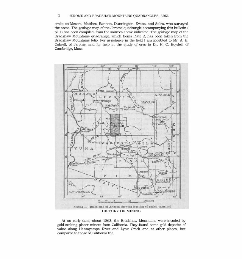
In the summer of 1922, at the request of the Director of the United StatesGeological Survey, I undertook an examination of the ore deposits in the Jeromeand Bradshaw Mountains quadrangles, Ariz. (See fig. 1.) The object of this workwas not a detailed investigation of each deposit but rather a coordination andclassification of the occurrences and an attempt to ascertain their origin andeconomic importance. Almost all the deposits occur in pre-Cambrian rocks or inrocks that are not readily differentiated from the pre-Cambrian. In the northernpart of the Jerome quadrangle there are large areas of almost horizontalPaleozoic beds, and in both quadrangles there are also large areas of lava flowsof Tertiary age. Finally there are wide spaces occupied by Tertiary tuff andlimestone, or by Tertiary and Quaternary wash filling the valleys between themountain ranges. But all these rocks except the pre-Cambrian are practicallybarren of ore deposits, and the problem therefore narrowed itself to anexamination of the pre-Cambrian areas. This task was greatly facilitated by thecareful work of Jaggar and Palache, set forth in the Bradshaw Mountains folio,lin which the southern quadrangle of the two under present consideration ismapped geologically and described, and which also includes a comprehensivethough brief discussion of the mineral deposits. There is no published geologicmap of the Jerome quadrangle, but I had the opportunity through the courtesyof Dr. G. M. Butler, Director of the Arizona Bureau of Mines, to use amanuscript map of this area prepared for the State by Mr. L. E. Reber, jr., andMr. Olaf Jenkins.
It would have been desirable to include the Congress quadrangle, to the west,in this reconnaissance, but the time and funds available did not permit thiswork. The topographic maps of the two quadrangles examined are ofconspicuous excellence and reflect great
1 Jaggar, T. A., jr., and Palache, Charles, U. S. Geol. Survey Geol. Atlas, BradshawMountains folio (No. 126), 1905.
1
2 JEROME AND BRADSHAW MOUNTAINS QUADRANGLES, ARIZ.
credit on Messrs. Matthes, Bannon, Dunnington, Evans, and Stiles. who surveyedthe areas. The geologic map of the Jerome quadrangle accompanying this bulletin (pl. 1) has been compiled .from the sources above indicated. The geologic map of theBradshaw Mountains quadrangle, which forms Plate 2, has been taken from theBradshaw Mountains folio. For assistance in the field I am indebted to Mr. A. B.Colwell, of Jerome, and for help in the study of ores to Dr. H. C. Boydell, ofCambridge, Mass.
HISTORY OF MINING
At an early date, about 1863, the Bradshaw Mountains were invaded bygold-seeking placer miners from California. They found some gold deposits ofvalue along Hassayampa River and Lynx Creek and at other places, butcompared to those of California the
"
FHa: •• I.-Index map or ArllQlla sbowlng locatioD or region u"mlned
HISTORY OF MINING 3
gravels were not rich, and this early placer mining left no permanentimprint on the region. Conditions were unfavorable as to trans-portation, and mining was handicapped by hostile Indians.
The first lode mining began about 1875, when many of the richsilver-gold mines were located—for instance, the Tiger, Tiptop, WarEagle, Del Pasco, Peck, Silver Belt, and Bigbug. The earliest locationsin the Verde district, near Jerome, are said to have been made in1876. This second epoch of discoveries and mining was initiated byprospectors from the Comstock and other recently discovered richsilver camps in the Western States. The development was, of course,stimulated by the building of the Southern Pacific and Atchison,Topeka & Santa Fe railroads in 1881. The transportation of ore,which had been laboriously and expensively sent to Swansea, Wales,by way of Colorado River and the Gulf of California, now becameeasier, and the shipments were sent to Denver and San Francisco.Many small mills and smelting works were built. Such smelters werelocated at Copper Mountain, Walker, Blue Dick, Briggs, Whipsaw,Mayer, and other places, but most of them were failures. The earliestsuccessful plant was the one near Mayer, built in 1901 by the ValVerde Copper Co. The mills were more productive; pan amalgamationand plate amalgamation were tried in succession and were laterfollowed by the cyanide and flotation process. The larger part of thegold and silver produced in the earlier years was derived from localmills.
About 1885 many of the rich oxidized ore bodies were worked outand leaner ore was found in depth. However, the activity continued,with many failures, to about 1905. Since that time a gradual declinehas taken place in the Bradshaw Mountains, while the Jeromedistrict has risen to predominance by the development of the UnitedVerde mine, which may be said to date from 1894. Spurred by theUnited Verde discovery a great and more or less continuous activityhas been shown near Jerome in attempts to find similar large copperdeposits. Most of these attempts have been failures, but in 1914 thesearch was rewarded by the discovery of the phenomenally rich orebodies now worked in the United Verde Extension mine. At presentJerome is the center of the mining activity in the region, completelyovershadowing the older Bradshaw area.
In 1922, when this examination was undertaken, the Bradshawarea showed evidence of decline and neglect. Many of the old roads,in good condition in 1900, are now impassable, and the trails, over-grown by brush, can hardly be followed. The population has de-creased, and many properties are abandoned, cattle seeking shelter
4 JEROME AND BRADSHAW MOUNTAINS QUADRANGLES, ARIZ.
in the old mill buildings and the wind rattling with dismal effect in the sheet-iron roofs.
At Jerome two first-class copper mines are producing heavily, with aconsiderable output of gold and silver as by-products. The ores from thesemines are reduced in two smelters near Clarkdale, in the Verde Valley, belowthe mines. (See pl. 12, A.) The rest of the Black Hills is making only a negligibleproduction, though containing many small deposits.
The southern, western, and northern parts of the Jerome quadrangle areunimportant so far as mining is concerned.
In the Bradshaw Mountains quadrangle most of the mines were idle, andonly one small mill was in operation in 1922.
The mainstay of the region is the Humboldt smelter, a few miles north ofMayer. This plant had been closed during the war, but the furnaces werestarted again in July, 1922, by the Southwest Metals Co., successors to theConsolidated Arizona Smelting Co. The principal source of ore for this smelteris the Blue Bell mine, which with the De Soto and Binghampton mines has inlater years furnished a large amount of pyritic copper ore. Such of the smallermines as are in operation generally ship their ore to this smelter. Most of theshipments are small, but in the aggregate they form a considerable quantity.
Parcels of rich oxidized ore are still coming in from many districts, but thefact is, and it might as well be faced, that the primary, sulphide ores aregenerally of a grade dangerously close to the lower limit. This statement appliesquite generally to the Bradshaw Mountains but of course is not universallytrue. The Sheldon mine, at Walker, for instance, finds it profitable to ship itssulphide ore to Humboldt. The very unfavorable conditions of wartime closedmany mines that may well be reopened with profit. Perhaps this would be trueof some of the mines on veins in the Hassayampa district near the Senatormine, some that have yielded well in the vicinity of Chaparral and McCabe, andperhaps some in the Crown King district. Nevertheless, ores containing $5 to$10 to the ton are much more plentiful than those of higher grade. This grade,of course, is prohibitively low for shipment to a smelter, and progress should bedirected to the construction of proper mills able to concentrate cheaply. Freegold will have to be amalgamated, but in the deeper ores the proportion of thismaterial is usually small.
The war, the scarcity of miners, and the high prices of supplies naturallyaccount to some extent for the present depressed state of the industry. Betterconditions may be hoped for, and with careful and economical work a numberof deposits may be expected to prove remunerative. It would be unfortunate ifthe Humboldt
PRODUCTION 5
smelter should find the available ore supplies insufficient to justify continuedoperation. In that event ores and concentrates would be shipped to Douglas,Ariz., or to El Paso, Tex. A branch road from Prescott to Humboldt, Mayer, andCrown King now serves the central part of the region. For some time the servicefrom Mayer to Crown King was practically suspended.
PRODUCTION
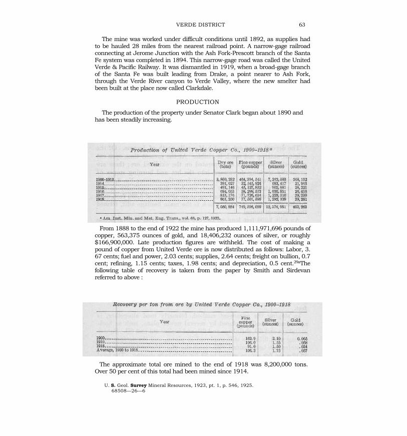
The two quadrangles here described contain the greater part of the workabledeposits in Yavapai County. In the adjacent Congress quadrangle, to the west,also in this county, there are a considerable number of mines, though most ofthem are now closed. Among these are the Octave and Congress gold mines,which about a decade or two ago were notable producers. Of late years theproduction of Yavapai County is not far from representing that of the Jeromeand Bradshaw Mountains quadrangles. This yield is annually recorded by theUnited States Bureau of Mines through V. C. Heikes, of Salt Lake City, who is incharge of the statistics for Arizona and certain other Western States. The figuresof the mine production are recorded below. For the earlier years no separaterecord of the several metals was kept, and the figures given are taken from there-ports of the Director of the Mint. They are incomplete and often omit the goldand silver produced from lead and copper bullion. Since 1894 the productionfrom the United Verde mine and since 1915 that from the United VerdeExtension have overshadowed the production from the Bradshaw Mountainsalmost completely. In the Jerome quadrangle practically the whole production isderived from these two mines, but that from the Bradshaw Mountainsquadrangle is obtained from about a hundred small mines.
Gold and silver produced in Yavapai County, Ariz., 1883-1901
[From reports of the Director of the Mint]
6 JEROME AND BRADSHAW MOUNTAINS QUADRANGLES, ARIZ.
Gold, silver, copper, lead, and zinc produced an. Yavapai County, Ariz.,1902—1924
(From V. C. Heikes, in U. S. Geological Survey Mineral Resources]
a Large companies closed owing to depression, but now operating.
The whole production of the two quadrangles to the end of 1923probably approaches $300,000,000, including the total value of gold,silver, copper, lead, and zinc. No other metals are produced innoteworthy amounts. Jaggar and Palache2 estimate the total pro-duction of gold and silver in the Bradshaw Mountains quadrangle tothe end of 1901 at $9,500,000, which I am convinced is too low. Theoutput scarcely reaches $1,000,000 in any one year and in many yearsit falls very much below that figure. From the approximately knownproduction of 23 mines in this quadrangle I have obtained the sum of$14,000,000, and I believe that the total gold and silver from 1875 tothe end of 1923, or almost 50 years, is not less than $18,000,000,which would represent an average annual output of $360,000. Ofcourse the production has fluctuated greatly and some placer gold wasproduced before 1875.
MINING DISTRICTS NEAR AREA HERE DESCRIBED
Yavapai County includes a number of mining districts not describedin this report, which is confined to the Bradshaw Mountains andJerome quadrangles. East of these quadrangles are the Squaw Peakdistrict, 10 miles south of Camp Verde, and the Copper Creek andSquaw Creek districts, east of the Black Canyon district, none ofwhich have made any notable production. On the southwest side
2 U. S. Geol. Survey Geol. Atlas, Bradshaw Mountains folio (No. 126), 1905.
GENERAL GEOLOGY 7
of the Bradshaw Mountains quadrangle are the Red Picacho, White Picacho,Blue Tank, and Black Rock districts. The Black Rock district includes a numberof gold and silver mines, some of which have been more or less productive. TheWalnut Grove district, a short distance west of Copperopolis, includes a greatnumber of small properties and some placer ground. The Copper Basin district,west of Prescott, has a fairly large output of copper and some molybdenum to itscredit. The Weaver and Martinez districts, still farther west contain, respectively,the Octave and Congress mines, which have been large producers from goldquartz veins but are now idle. In the extreme western part of the county lies theHarcuvar district, and in the northwest corner the Ochocomo and Eurekadistricts. The Eureka contains the Bagdad mine, which has a large copperdeposit far distant from rail communication and is not extensively operated.
GENERAL GEOLOGY
P H Y S I O G R A P H Y
The area here described is approximately 70 miles long from north to southand 28 miles wide and lies between parallels 34° and 35° and meridians 112°and 112° 30'. The altitude ranges from 1,900 feet at the most southerly point ofAgua Fria River to 7,971 feet on the summit of Mount Union, in the BradshawMountains.
According to Ransome, Arizona may be divided into three physiographicprovinces trending northwest—the plateau region of flat-lying Paleozoicsediments; the mountain region, an area of irregular mountain masses, lyingsouthwest of the plateau; and the desert region of short ranges trending north ornorthwest and separated by wide stretches of desert plains. The limit betweenplateau and mountain is sharply marked by recessed cliffs of horizontalPaleozoic beds, which are prominent in the landscape and are known as " thebreaks." From northwest to southeast there are in succession many suchbreaks, beginning on Colorado River with the Grand Wash Cliffs, which aresucceeded in turn by Music Mountain, by the Verde breaks, in the area herediscussed, and by Mogollon Mesa, farther southeast.
The area considered in this paper extends across the Verde breaks andincludes a part of the mountain region. It presents many physiographicproblems of the first magnitude, which can only be briefly touched upon.
We have to deal with comparatively few units, already referred to on page 1.The flat-lying Paleozoic beds occupy the larger part of the northeastern section ofthe Jerome quadrangle. They rest
8 JEROME AND BRADSHAW MOUNTAINS QUADRANGLES, ARIZ.
on the peneplaned surface of the pre-Cambrian, and their thickness, from thebasal beds (Cambrian) to the top of the Coconino sandstone (Permian), amountsto 2,500 feet. Gradually thinned out by erosion, the southern outliers rest onpre-Cambrian granite in the south end of the Black Hills.
Strong fault lines of recent date mark the eastern slope of the Black Hills—infact, the Verde fault, with a throw of at least 1,700 feet—can be tracedcontinuously across the whole northeastern part of the Jerome quadrangle farinto the plateau province. It is scarcely to be doubted that other older faultsoutlined the western slope of the Black Hills and all four sides of the BradshawMountains. The plateau province is thus adjoined by a series of pre-Cambrianfault blocks, and few areas offer as good an opportunity to investigate therelation of mountain to plateau.
The top of the plateau attains 6,000 feet in the northeast corner of the Jeromequadrangle. The mountain region includes two main masses - the Black Hillsand the Bradshaw Mountains. The Black Hills consist of an irregular orographicblock capped in part by flat Paleozoic beds and Tertiary lavas, trending north-northwest for about 20 miles and 8 to 12 miles wide. This block is doubt-lessoutlined by faulting and merges on the north into the flat plateau rocks. On theeast it is delimited by the deep Verde Valley, filled by late Tertiary deposits; onthe west by the higher plains of Lonesome Valley.
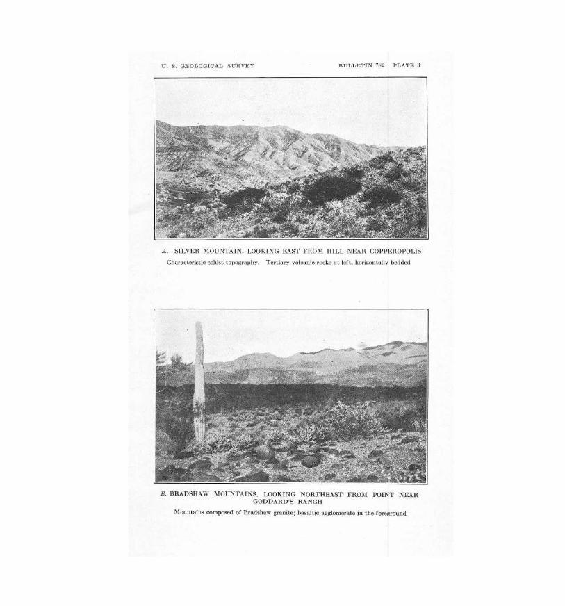
South of this range rises the irregular block of the Bradshaw Mountains,occupying about the whole of the Bradshaw Mountains quadrangle. (See pl. 3,B.) Essentially these mountains are a series of broad ridges trending north ornorth-northwest and dissected by a vast number of valleys and gulches thatgenerally drain southward. At the south end of the quadrangle the ridges dipbelow the lava flows of the lower Agua Fria River, and the topography of the low-lying pre-Cambrian rocks becomes an intricately dissected landscape ofirregular ridges and sharp points or " picachos."
The drainage is southward toward Gila River, by Hassayampa, Agua Fria, andVerde Rivers. The Hassayampa drains the western edge of the BradshawMountains quadrangle, and the Agua Fria the central part. Stream captureeffected by the active southward drainage is much in evidence. Thus the AguaFria has captured the drainage of Lonesome Valley, and the Verde through asharply incised canyon has captured streams draining much of the plateauregion in the northern part of the Jerome quadrangle.
The Tertiary lavas (see pl. 3, A) occupy scattered areas on the plateau in thenorth and also much of the eastern half of the
U. 8. GEO[,OGlC A L SURVE Y BUL LETIN 78 2 PLA TE S
.1 , SI LVER ~ ' OUNTAIN , LOOKING EAST FROM HiLL NEAR COPPEROPOLIS
Characteristic ""hi.t t ol"'llraploy. Tertiary volcanic r()(Ju at left, horiz<>Dtati)' t..,Jded
B. IJRA DSHAW MOUNTAI NS. LOOKI NG NonTIlEAST FRO.\{ POINT NEAR GOOOAHO'S RANCH
Mountains oomposed <;If Bradshaw If'"anil~ ; haonltic agglomerate in the fOl"'egrODOd
GENERAL GEOLOGY 9
Bradshaw Mountains, which drops off sharply from the pre-Cambrianridges of the western half. In the latter region they form a dissectedplateau with a surface altitude of about 4,000 feet. The advent of thelate Tertiary lava flows modified the drainage to a considerable extent.Thus probably the whole of the lower Agua Fria was laid out along anew course over the flows in the eastern part of the BradshawMountains quadrangle. But in the main the drain-age far antedates theflows.
PALEOZOIC SEDIMENTS
The series of flat Paleozoic sandstones and limestones as exposed inthe northeast corner of the Jerome quadrangle has a thickness of about2,500 feet. The approximate succession as recorded by Ransome,3 withchanges in age assignment to accord with present classification, is asfollows :
Section of Paleozoic formations in Jerome quadrangleFeet
These beds are in full view from points near Jerome on the upperslopes of the Black Hills, across the Verde Valley, and present awonderful geologic panorama. The Tapeats sandstone forms a narrowbrown band rarely to be observed from a distance.The Devonian beds are pale yellow and gray; above them rests the whiteRedwall limestone, and this in turn is covered by the Supai sandstones,which gleam brilliantly red when illumined by the rays of the settingsun. The level top of the plateau in the extreme corner of thequadrangle is surmounted by a narrow dark fringe of the pine forests,and the slopes below are bare and sculptured by erosion into a series ofsalients and recesses, with battlements and towers alternating withgentler slopes.
This section is materially thinner than those obtained along theGrand Canyon; at Tovar the strata measure 3,600 feet up to the top ofthe Coconino. The Devonian, however, which is represented
in the Grand Canyon by 100 feet or less of Temple Butte limestone,
3 Ransome, F. L., Some Paleozoic sections in Arizona and their correlation : U.S. Geol. Survey Prof. Paper 98, pp. 159-162, pl. 25, 1916.
4 The basal quartzite at Jerome has not been definitely identified as theTapeats (Cambrian) formation.
10 JEROME AND BRADSHAW MOUNTAINS QUADRANGLES, ARIZ.
appears to be thicker here, although some of the 500 feet of lime-stone soclassified may not be of Devonian age. Both sections agree in that they arerelatively thin compared with the 30,000 feet of Paleozoic beds in easternNevada. Furthermore, both sections in Arizona, though apparentlyconformable, include several unconformities, so that there are many gaps inthe succession.
The region here described is part of a large positive element of the crust,which in general has tended to rise. It is not a part of any geosyncline.
PRE-PALEOZOIC PENEPLAIN
The Paleozoic beds were laid down on a surface peneplaned by long erosion.As the sea advanced it destroyed any surface debris that might haveaccumulated, and a basal sandstone or fine con-glomerate was laid down, firstknown as the " Tonto " sandstone and determined as Cambrian in severalsections. Along the Grand Canyon these beds are several hundred feet thickand are overlain by 200 or 300 feet of Cambrian shale. In the Jerome sectionthe " Tonto " (now called Tapeats) sandstone averages only 50 feet and, indeed,in places thins out almost entirely. It is overlain by a slight thickness of shale,which may represent the Bright Angel shale of the Grand Canyon section, andabove this is the so-called Devonian limestone. The age of the sandstone atJerome has not been proved, but it looks like the Tapeats sandstone of theGrand Canyon area, which contains Cambrian fossils. Just north of LonesomeValley the Tapeats (?) is again exposed, and here it appears to be somewhatthicker than at Jerome.
We may assume, then, that the Cambrian sea advanced south-ward,transgressing over the pre-Cambrian peneplain, which gradually rose in thisdirection. Whether the Paleozoic beds up to the top of the Coconino sandstonecovered the whole of these two quadrangles is a question open to discussion.The lowest Supai red beds form the uppermost part of the Paleozoic section inthe Black Hills and directly underlie the Tertiary basalt.
RELATION OF THE PLATEAU PROVINCE TO THE MOUNTAINREGION
The pre-Cambrian peneplain now lies at an altitude of 3,400 feet in theBright Angel and Vishnu quadrangles of the Grand Canyon region. In theShinumo quadrangle,5 adjoining the Bright Angel on the west, the samehorizon lies at 2,400 to 3,400 feet, the contact being very irregular in spots,though comparatively level as a whole.
5 Noble, L. F., The Shinumo quadrangle, Grand Canyon district, Ariz.: U. S. Geol. SurveyBull. 549, 1914.
GENERAL GEOLOGY 11
Southwest of Ash Fork, on the main line of the Atchison, Topeka & Santa FeRailway, we find the same peneplain at an altitude of 4,800 feet. This is about65 miles south of the Grand Canyon. About 25 miles farther south the base ofthe Tapeats crops out along Verde River at altitudes of 4,400, 4,200, 3,700, and3,600 feet; the lowest figure was obtained at Packard's ranch, 6 miles north ofClarkdale. About 8 miles farther south, at the north edge of Lonesome Valley,the same basal plane lies considerably higher, at, 5,200 to 5,300 feet. Stillfarther south, on the west side of the Black Hills, we find it at 6,000 to 6,400feet, and at the south end of the hills, near Cherry, at 5,600 feet. On the eastside of the Black Hills the Tapeats rests on the pre-Cambrian at 6,000 feet, butjust east of the Verde fault, as shown in the Edith shaft of the United VerdeExtension mine, it is thrown down to 4,230 feet.
In the Verde Valley, at the smelters of Clarkdale and Clemenceau, boringsthrough the white lake beds of the Verde formation have encountered the pre-Cambrian at a depth of 1,200 feet,6 or an altitude of 2,000 feet. Evidently thereis here a deep depression in the pre-Cambrian surface, but it may possibly bedue to more intense erosion of the pre-Cambrian beds in this particular arearather than to faulting.
To sum up, it appears that the position of the top of the pre-Cambrian isabnormally high in the Black Hills and abnormally low in the Verde Valley.
It would seem at first glance that the cliffs that mark the edge of the plateauprovince and stand up above the surrounding country indicate an uplift of theplateau. This is not so, however. Along the Grand Wash Cliffs runs a deep faultalong which the country to the east has been relatively thrown down, andpoints in the Kingman and Hualpai ranges, to the southwest, stand high abovethe Tapeats horizon. W. T. Lee' interprets the structure in this area, southwestof Music Mountain, to the effect that the southwest side has been broken upinto eastward-tilted fault blocks, from which an enormous erosion has removedthe Paleozoic blocks. According to Ransome,8
South of Ash Fork the continuity of the plateau escarpment is interrupted byflaws of basalt that poured down from the plateau to the valley of the Verde,forming a slope that has been utilized by the Santa Fe, Prescott & PhoenixRailway between Ash Fork and Jerome Junction.
East of this slope the escarpment again begins, forming the " Verde breaks,"already referred to as visible from Jerome.
6 Finlay, J. R., The Jerome district of Arizona : Eng. and Min. Jour., vol. 106, Sept. 28and Oct. 5, 1918.
7 Lee, W. T., Geologic reconnaissance of a part of western Arizona : U. S. Geol. Survey :Bull. 352, 1908.
8 Ransome, F. L., op. cit., p. 134.
12 JEROME AND BRADSHAW MOUNTAINS QUADRANGLES, ARIZ.
All this is interpreted as follows: Between the Grand Canyon and the upperVerde Valley the pre-Cambrian peneplain is fairly uniform, ranging from 3,600to 4,800 feet in altitude over a distance of 100 miles. The Black Hills form anuplifted block, perhaps slightly tilted, separated by an obscure fault line fromLonesome Valley and by a well-marked fault, the Verde fault, from thedepressed block on the west side of the Verde Valley. The Verde fault is laterthan the basalt and the Verde beds and is therefore of very late Tertiary or post-Tertiary age. It trends north-north-west and breaks into the plateau countrywhere it crosses the upper canyon of the Verde. The downthrow amounts to 1,700 feet, and the fault has several branches, according to the mapping by Jen-kins and Reber. Near the base of the slope in the vicinity of Clarkdale there isprobably another parallel fault of unknown magnitude. In the block or "horst "of the Black Hills the base of the Tapeats lies abnormally high - that is, from 5,300 to 6,400 feet above the sea. The conclusion is that the block of the BlackHills has been lifted or tilted, and at the same time there has been a downwardmovement of a block underlying the Verde Valley. The effect is a relativedepression of the edge of the plateau.
It is likely that there are other block faults, probably of earlier formation.Almost certainly one runs from north to south dividing the lava-flooded easternpart of the Bradshaw Mountains quadrangle from the higher mountainousregion of the western half. The highest altitudes in this quadrangle lie between7,000 and 8,000 feet. It is clear that if Paleozoic rocks rested on top of thesehighlands they would have attained a height at least equivalent to a presentaltitude of 10,000 feet. On any supposition the mountain province has risenrelatively to the edge of the plateau. Actually, I think, the Paleozoic beds thinnedout very much toward the south, and the Bradshaw highlands may never havebeen covered.
Supporting evidence for this suggestion is found in the followingconsiderations : There are in the Bradshaw Mountains several stocks ofgranodiorite, some of them several miles in diameter, which are believed to be ofMesozoic age. Their present exposures reach an altitude of 7,500 feet and couldhardly have been less than 3,000 feet below the Mesozoic surface. That surfacemay have been formed by flat Paleozoic beds or by the partly eroded pre-Cambrian peneplain. Furthermore, the Bradshaw Mountains are intersected byone of the most remarkable systems of dikes in the world, which reach at least7,500 feet in altitude and which must have penetrated to the surface andproduced volcanic flows of vast extent. Of these flows there are now no traces.This system of rhyolite dikes is genetically con-
GENERAL GEOLOGY 13nected with veins of epithermal to mesothermal type, most probably formed atdepths not less than 3,000 feet.
All in all, I see no escape from the conclusion that the present exposures inthe Bradshaw Mountains are about 3,000 feet or more below the pre-Cambrianerosion surface and that at the end of Paleozoic time these mountains projectedas a vast dome above the edges of the transgressing sediments.
The only alternative would be to assume strong faulting or de-formationbetween the Black Hills and the Bradshaw Mountains, which may havechanged their relative elevations. Some such faulting may have occurred but isprobably not sufficient to explain the absence of Paleozoic strata in theBradshaw Mountains.
POST-PALEOZOIC EROSION
An enormous erosion intervened in the northern part of the mountainprovince between the deposition of the Kaibab limestone and the next notableevent—the outpouring of the Tertiary basalt and allied rocks. The basalt restson the Supai formation only in the northeast corner of the Jerome quadrangleand the northern part of the Black Hills. Elsewhere it rests mostly on theDevonian limestone or the Tapeats sandstone, or, as in parts of the Black Hillsand over the whole of the Bradshaw Mountains, on the pre-Cambrian rocks.
The second period of erosion was postbasaltic and post-Tertiary. It also wasof tremendous extent. It included the excavation of the main Verde Valley, bothsides of the uplifted fault block of the Black Hills, and the whole upper VerdeRiver above Packard's ranch and the trenching of the Bradshaw Mountains bydeep canyons, which are best measured around Bigbug Mesa. It included thecutting of the new canyon of the Agua Fria and its capture of Lonesome Valley ;also the capture by Verde River of its whole upper drainage system in thenorthern part of the Jerome quadrangle. Rarely can such vast physiographicchanges be observed.
VOLCANIC FLOWSThough the Tertiary flows were well scattered over the whole area (see pls. 1
and 2), they were not of great thickness, probably nowhere more than 700 or800 feet, and as a rule much thinner. In the Jerome quadrangle they consistmainly of basalt, but in the Bradshaw Mountains there are also some andesiteand rhyolite and much mixed volcanic agglomerate. Feeders such as necks anddikes are to be seen in many places, but no volcanoes or craters remain. Theage of the flows, according to Robinson's determination in the San Franciscanfield, is believed to be Pliocene.
14 JEROME AND BRADSHAW MOUNTAINS QUADRANGLES, ARIZ.
The main flows descended toward Lonesome Valley and the BlackHills from the plateau in the vicinity of Flagstaff and Bill WilliamsMountain. Another vast flow covered the depression in the east half ofthe Bradshaw Mountains quadrangle and no doubt followed theTertiary equivalent of Agua Fria River. Still another line of flows maybe observed along the western margin of the same quadrangle andmay be considered as filling a branch of the Tertiary equivalent of theHassayampa.
VERDE FORMATION
The main Verde Valley is now filled to a depth of at least 1,500 feetby the white lake beds which Reber 9 and Jenkins 10 have called theVerde formation. The valley from Packard's ranch down to a pointbeyond the limits of the Jerome quadrangle may have been outlinedby the pre-basalt erosion, but in late Tertiary or Quaternary timedislocations parallel to the edge of the plateau caused it to sink like adeep graben. The whole of Verde River is therefore a comparativelylate development. The lake beds rest on the faulted blocks. On Plate 1the Verde formation is classified as Pliocene, but it may be ofPleistocene age.
LATEST FORMATIONS
The most recent formations include certain low river terraces andalluvial deposits in the Verde and Lonesome valleys.
PRE-CAMBRIAN ROCKSGENERAL FEATURES
The pre-Cambrian rocks occupy large areas in the southwesternhalf of Arizona. They emerge from under the flat Paleozoic rocks of theplateau province along the diagonal line of "the breaks," as is wellillustrated in the northeastern part of the Jerome quadrangle. Southof this line they appear in nearly every mountain range from Clifton,Globe, and Bisbee to Kingman, Yuma, and Parker. Toward the norththese rocks are not exposed for long distances except where they arelaid bare in the narrow trench of the canyon of Colorado River.
W. P. Blake,111 when Territorial geologist of Arizona, first de-scribed them in 1883. Since then they have been investigated by
9Reber, L. E., jr., Geology and ore deposits of the Jerome district : Am. Inst. Min. andMet. Eng. Trans., vol. 66, pp. 8-11, 1922. Adopts Jenkins's proposed name Verde forma-tion.
10 Jenkins, O. P., Verde River lake beds near Clarkdale, Ariz.: Am. Jour. Sci., 5th ser.,vol. 5, pp. 65-81, 1923.
11Blake, W. P., Geology of the Silver I{ing mine : Eng. and Min. Jour., vol. 35, pp. 238-239, 1883; also in the reports of the Governor of Arizona, 1896-1899, particularly in reportfor 1899, p. 139.
GENERAL GEOLOGY 15
many geologists, particularly by Jaggar and Palache12 in the BradshawMountains; by Ransome13 at Ray, Miami, and Bisbee and in the MazatzalMountains; by Lindgren14 at Clifton; by Schrader15 and Bancroft16 in thewestern part of the State adjoining Colorado River; by Bryan17 and Ross18 insouthwestern Arizona.
The pre-Cambrian rocks of Arizona may be divided as follows:Grand Canyon series : Algonkian, probably of the same age as the Belt series of
Montana and Idaho. Bedded sediments. Not definitely recognized except inGrand Canyon.
Mazatzal and other quartzites : Probably late pre-Cambrian.Dike intrusions: Diorite porphyry (Jerome), diabase porphyry (Blue Bell mine).
Latest pre-Cambrian. Not schistose.Granites : Large widely distributed masses of intrusive normal granite with more
or less pegmatite. In the region here described it is called the Bradshawgranite. In places gneissoid.
Diorite, "quartz porphyry," and monzonite : Smaller masses intrusive in schistand probably a fades of the granite.
Schists: Highly compressed, intruded by the granites. They are known as the Pinalschist at Globe, Ray, Clifton, and Bisbee, where they are pre-dominantly ofsedimentary origin. Near granites they are metamorphosed and may containandalusite, sillimanite, and staurolite. They are known as the Yavapai schist inthe Bradshaw Mountains quadrangle, where they are in large part also ofsedimentary origin. They are known as the Vishnu schist in the Grand Canyon,where they unconformably underlie the Grand Canyon series. There is noreason to doubt that in the main these schists represent the same formation.The name "Arizonian schist " would, in my opinion, suit all these occurrencesvery well.
The schists are the earliest known pre-Cambrian rocks, though theoccurrence in them of conglomerates made up of granite, quartzite, and otherrocks would indicate that there existed an older series from which they werederived. At present all the granite with which they are in contact is intrusive.
The pre-Cambrian also includes certain flat-bedded sediments, consisting ofslate, quartzite, limestone, and amphibolite, found near Parker on ColoradoRiver and in the Harcuvar Range. They rest on older gneissoid and graniticrocks, and their correlation is
12Jaggar, T. A., Jr., and Palache, Charles, U. S. Geol. Survey Geol. Atlas, BradshawMountains folio (No. 126), 1905.
13 Ransome, F. L., Geology of the Globe copper district : U. S. Geol. Survey Prof. Paper 12,1903; Geology and ore deposits of the Bisbee quadrangle, Ariz.: Prof. Paper 21, 1904 ; Thecopper deposits of Ray and Miami, Ariz.: Prof. Paper 115, 1919 ; Quicksilver deposits of theMazatzal Range, Ariz.: Bull. 620, pp. 111-128, 1916.
14 Lindgren, Waldemar, The copper deposits of the Clifton-Morenci district, Ariz. : U. S.Geol. Survey Prof. Paper 43, 1905.
15 Schrader, F. C., Mineral deposits of the Cerbat Range, Black Mountains, and GrandWash Cliffs, Mohave County, Ariz.: U. S. Geol. Survey Bull. 397, 1909.
16 Bancroft, Howland, Reconnaissance of the ore deposits in northern Yuma County, Ariz.:U. S. Geol. Survey Bull. 451, 1911.
17 Bryan, Kirk, Erosion and sedimentation in the Papago country, Ariz.: U. S. Geol. Survey
Bull. 730, pp. 19-90, 1922.18 Ross, C. P., Geology of the lower Gila region, Ariz. ; U. S. Geol. Survey Prof. Paper 129,
pp. 183-197, 1922.
16 JEROME AND BRADSHAW MOUNTAINS QUADRANGLES, ARIZ.
not known. They are not identical with the Yavapai schist nor with the GrandCanyon series, and they are not intruded by granite. In this region theunderlying granite is much more gneissoid than elsewhere. Whether or not itis of the age of the Bradshaw granite it uncertain.
DIKE INTRUSIONS
Dikes intruded at just about the end of the pre-Cambrian period ofmineralization and probably of the age of the Bradshaw granite have beenfound in several places but are of small extent. At Jerome they are narrow,strike east, and seem to be related to diorite porphyry. They are greatlydecomposed and cut across the diorite, schist, and pyritic deposits. Thepersistent dike that cuts across the Blue Bell mine is a panidiomorphic dikerock with labradorite, augite, brown hornblende, and a little sericite andchlorite. Possibly it is later than the pre-Cambrian.
BRADSHAW GRANITE
The typical rock of the Bradshaw granite is white, of coarse to mediumgrain, and forms large rounded outcrops of yellowish-gray color. It is uniformover large areas and is rarely gneissoid, though evidence of strain iscommonly observed in thin sections. In color it differs from the pre-Cambriangranite at other places—that at Clifton, for instance, which is dark reddish. Iteverywhere contains quartz, orthoclase, and microcline, and in placesperthite, with some plagioclase, which may be zoned, and which is generallyan oligoclase-albite. The dark constituents are scarce and consist of biotiteand rare hornblende. The accessories are apatite and zircon, but there is notitanite. A type locality is in the vicinity of Prescott. Reddish varieties occur inplaces, but differ little in composition from the normal type. Here and therethe rock is porphyritic, having larger microcline crystals. Jaggar andPalache, in the folio already cited, give a partial analysis of granite fromCrooks Canyon, as follows: Silica, 74.62 per cent; lime, 1.06; potash, 3.90;soda, 3.99. They say : "Pegmatitic facies are extremely abundant in the greatsouthern stock, particularly along the east-ern contact, where extensiveareas, practically all of pegmatite, are found." The vicinity of the Tiptop minewell illustrates this statement. Many of the pegmatite dikes containtourmaline.
The granite in the southern part of the Jerome quadrangle is normal, butin Lonesome Valley, in the Coyote Hills, and also at the north side of the samevalley there are many smaller masses of medium-grained granite poor in mica,some of it pegmatitic and of a yellowish to reddish color. In many places thesemasses are mixed with included masses of schist.
GENERAL GEOLOGY 17DIORITE AND MONZONITE
The smaller masses of diorite in the Bradshaw Mountains quad-rangle are fully described by Jaggar and Palache. They show a veryhard and dark medium-grained rock, which may be regarded .as afacies of the granite or at least a closely allied intrusive. Thesmaller masses of diorite at Jerome and the dikes at the Shea mine,south of Jerome, and the Yaeger mine, on the west side of the Black
Hills, are similar and are more fully described on pages 57, 92,and 98.
The gneissoid monzonite of Battle Flat is also fully described inFolio 126 and is probably of about the same age.
YAVAPAI SCHISTBRADSHAW MOUNTAINS QUADRANGLE
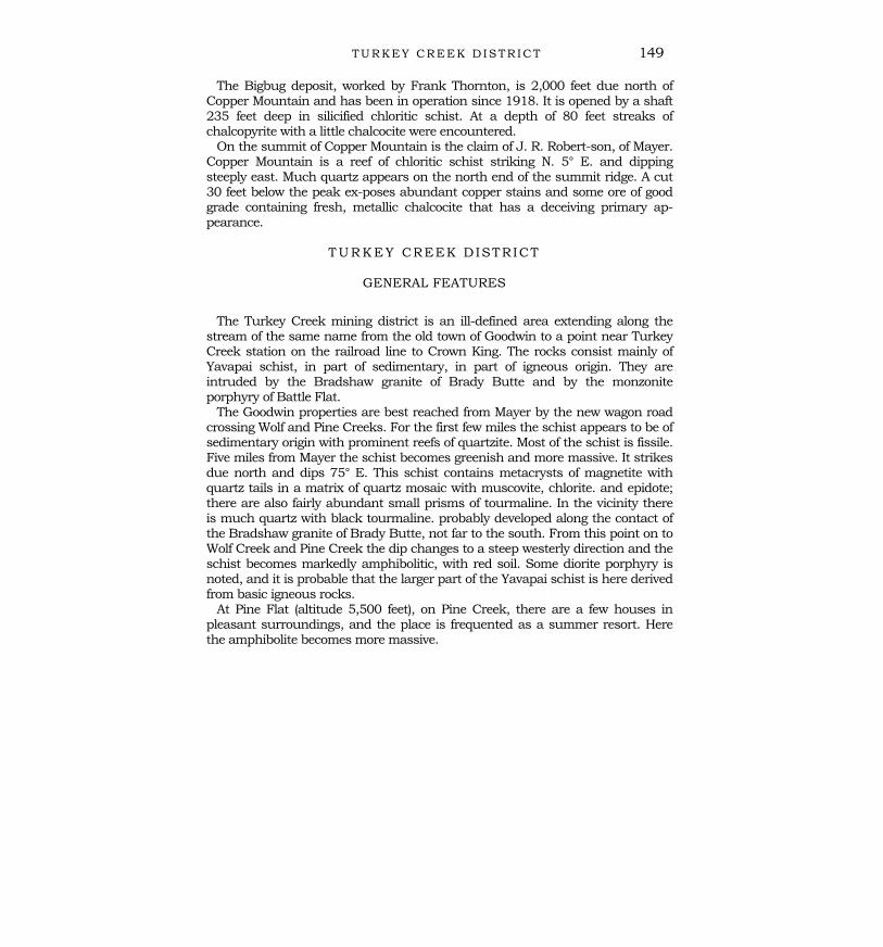
The schists, which occupy large areas in the Bradshaw Mountainsquadrangle, with a general northerly trend, were named the Yavapaischist by Jaggar and Palache. They continue northward into theJerome quadrangle, though here the exposures are much smaller. Theformation is described as follows by the authors cited :
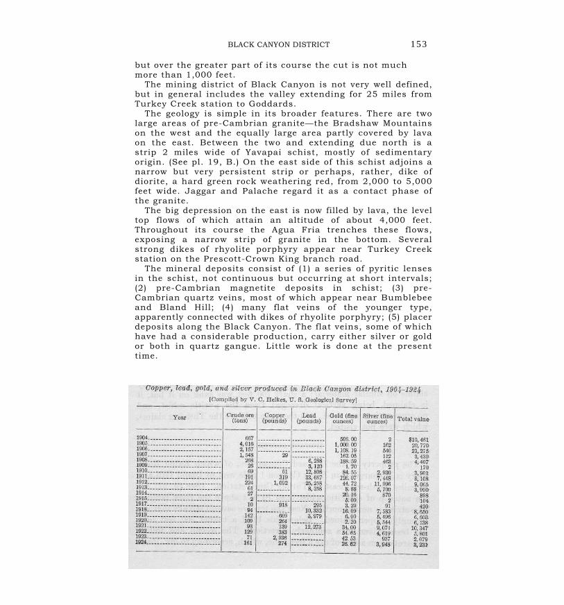
Chiefly phyllite, mica schist, and hornblende schist, with limestonelenses, quartzite, and siliceous schist lenses. * * Within the schist areasare conglomerate and sandstone bands and lenses, and zones of intensemetamorphism where the rocks are amphibolitic and contain epidote,garnet, zoisite, tourmaline, andalusite, and mica in various amounts. [There are also lenses containing much magnetite.] The typical phyllite asdeveloped in the great body of Yavapai schist which occupies thenorthern half of the center of the quadrangle is a finely foliated blue orsilvery schist consisting chiefly of quartz and the form of muscovite micaknown as sericite. The foliation is pronounced, but the surfaces of thepartings are not plane, so that nowhere are truly cleavable slates found.The rock consists largely of interlocking quartz grains, producing amosaic, the sericite being woven in between the grains or forming layerswrapped about individual grains. Occasionally single large roundedgrains of quartz are seen, their edges granulated. Plagioclase, calcite,epidote, zoisite, pyrite, and magnetite are often found in scattered grains.
The rocks are interpreted as a recrystallized and metamorphosedsedimentary series, and the conclusion is confirmed by the occurrence
of lenses of quartzite, conglomerate, and, more rarely, limestone.Certain rare facies of the schist, however, contain so much feldspar incrystal form that a local derivation of the schist from granite porphyryor some such rock seems likely.
The hornblende schists are a varied assortment. They includeamphibolites of doubtful derivation, some diabasic rocks, and some
schists in which the hornblende seems to be derived by contact meta-morphism. Near the granite staurolite, andalusite, and tourmalineappear.
18 JEROME AND BRADSHAW MOUNTAINS QUADRANGLES, ARIZ.
The schists have been altered by regional metamorphism and extremecompression, but also to a considerable extent by the contact-metamorphicaction of intrusive granite. The total thickness of the formation is in doubt. Anestimate based on sections is from 5,000 to 7,000 feet.
The preceding paragraphs summarize the conclusions of Jaggar and Palache.My own studies are far less extensive than theirs, but included detailedexaminations in each of the mining districts, and the general results are setforth as follows :
The first impression given by any typical section is that of very monotonoussilvery-white schists, the outcrops looking very much alike. An inspection ofmine workings, however, soon shows that this appearance is deceptive, foralthough a great variety of rocks present this appearance on the surface, thefresh rocks below vary greatly and are greenish, dark green, and brown frombiotite mica. The pure sericite schists do not predominate. The quartzite lensesare very characteristic, especially in the central part of the Bradshaw Mountainsquadrangle. I should say the predominating variety is chloritic mica schist, inpart doubtless of sedimentary origin. There are also small lenses of limestone,usually only a few feet thick and,. on the whole, very rare. Banded magnetitesoccur in many places. Some of them, as those near Copper Mountain, are redjasperoids, very similar to those of Lake Superior.
The amphibolites and allied greenstones are more abundant than the map inthe folio cited would indicate. In small part they may owe their origin to contactmetamorphism, but most of them are schistose and altered basic igneous rocks,probably effusive. Agglomerates with a dip differing from that of the normalschistosity are present—for instance, at the Binghampton mine, near Stoddard..A large part of the schists west of Wolf Creek, in the northwestern part of thequadrangle, have this origin.
Most prominent, however, are the schistose rhyolites or rhyolite porphyries;they are present in abundance in most of the districts examined, and wherethey have been pressed are almost indistinguishable from the normal chloriticschists. I suspect that the large quartz grains of which Jaggar and Palachespeak are really de-formed phenocrysts. Practically all the rocks at theBinghampton mine are of this character. They occur also at the Blue Bell mine,.in the Black Canyon, and at many other places, but in all these places realsediments are also present.
It would be fair to say, it is believed, that the Yavapai schist corn-prises aseries of sedimentary beds with a large amount of inter-bedded, supracrustaligneous rocks and tuffs. To what extent the-series contains intrusive rocks isdifficult to say; they are undoubt-
GENERAL GEOLOGY 19
edly present here and there and have been made schistose with the rest. Iwould not dare to assign a definite thickness to the series.
This mainly supracrustal series was closely folded and appressed andsubjected to regional metamorphism. The intrusion of the granite tends to followthe schistosity, so that great bands of schist are embedded in the granite with ageneral northerly direction. The effects of contact metamorphism are stronglymarked. Next to the granite coarse schists appear with andalusite andstaurolite, and in places probably also some amphibolite. Farther away brownmica seems to be the predominating mineral. In a few places, as at the Rainbowmine, in the Turkey Creek district, there are masses of epidote and garnet withpyrite, which seem to be contact-metamorphosed limestones. The effects mayextend for a mile, or even several miles, from the contact. Tourmaline developedfrequently, a mineral characteristic of granitic emanations. The tourmalinefound in the schist is, indeed, invariably later than the regional metamorphism.
JEROME QUADRANGLE
The southwesterly area of Yavapai schist between Prescott and Dewey isgreatly injected with granite, which in places is rudely gneissoid. The injectionalong the western border of this area is so extensive that it is difficult in placesto separate the two formations. Near the granite the rocks are mainlyamphibolites, black and lustrous, as at the Bullwhacker mine, but farther east,at the bridge across Lynx Creek, there are fissile slates and cherty beds intrudedby granite.
A long north-south belt about 1 mile wide of fissile, almost vertical schistscontinues northward from the Bradshaw Mountains quadrangle and is wellexposed on the Cherry Creek road, at the Shylock mine, at the Yaeger mine,and finally in a narrow strip below the Tapeats sandstone on the west side of theBlack Hills. Where the road from Dewey to Cherry Creek crosses this belt fromwest to east it consists first of brown and red volcanic agglomerate, followed bypurple schists and finally by a belt 500 feet wide of the usual chlorite-sericiteschist, all members striking N. 20° E. and standing about vertical. Below theShylock mine the same fissile schists appear, adjoined on the east bygreenstone schists and granite. Similar conditions are found below the Yaegermine.
In Lonesome Valley, north of the wagon road to Jerome, rises a complex oflow hills that consist in part of a massive light-colored reddish or yellowishgranite poor in dark minerals and rather fine-grained. In places the rocks showschistose structure; the granite injects numerous patches of strongly alteredschist. Similar rocks are found in the northern foothills of Lonesome Valley, butwithin a short distance to the north the pre-Cambrian rocks are covered by
20 JEROME AND BRADSHAW MOUNTAINS QUADRANGLES, ARIZ.
the Paleozoic sediments. In Yaeger Canyon on the road to Jerome thegreenstone series consists of fine-grained tuffs with interbedded masses offragmental greenstone, the series dipping 45° E. and having the usualschistosity superimposed.
In the Jerome district and adjacent parts of the Black Hills the Yavapai schisthas a distinctly differing facies. The greenstones are rudely schistose, rarelyfissile, and in several places show bedding by gently dipping layers of volcanicagglomerate. In the northern part of the district, about the town of Jerome,there is much rhyolite schist, usually light colored and poor in chlorite; some ofit is almost massive, the schistosity varying sharply in intensity. The rhyolite isin part clearly intrusive into the greenstone, but some of it may possibly consistof supracrustal flows. The areas of this rock are irregular, and in places it isintimately interlocked with the greenstone schist. The strike of the schistosity isgenerally north-northeast, but is subject to sharp variations.
In the southern part of the district fine-grained granitic rocks are found, alsointrusive in the greenstone schists. Reber thinks that there may be transitionsbetween the aplitic granite and the rhyolite porphyry, but I do not believe thatthis is proved. It seems more likely that the porphyry antedates the granite,which I believe is to be correlated with the Bradshaw granite.
The smaller areas and dikes of diorite at the United Verde, Shea, and Yaegermines are probably also to be considered as fades of the Bradshaw granite.Masses and streaks of clay slate, quartzite, banded chert, and other clearlysedimentary rocks are inter-bedded in the schists near Jerome, particularlynear the United Verde mine. It is believed that they are earlier than orcontemporaneous with the supracrustal volcanic rocks that make up the largerpart of the greenstone series.
CORRELATION
There seems to be no reason why the rocks near Jerome should be separatedfrom the Yavapai schist. They are predominantly volcanic and largelysupracrustal, but if it is admitted that the same schists in the BradshawMountains also contain large amounts of such rocks any distinction seemsfutile. I believe that all these schists, including the Pinal schist and the schists inthe Mazatzal Mountains and at many other localities in central Arizona, are ofapproximately the same age, and that Blake's name " Arizonian " would beeminently suitable for them as a whole. In detail they differ greatly : some arealmost entirely sedimentary ; others contain many different kinds of igneousschistose rocks. It is hopeless to separate them except locally. From this seriesshould be excluded the distinctly later intrusive rocks such as the diorite, the
GENERAL GEOLOGY 21Bradshaw granite, and other granites, which on the whole present amuch more massive appearance.
ROCKS OF DOUBTFUL AGE GRANODIORITE (QUARTZ DIORITE)
Jaggar and Palache called attention to certain bodies of quartz dioritein the Bradshaw Mountains quadrangle which differ strikingly from theother intrusive rocks here present. There are four areas of these rocksforming rounded intrusive masses at most a few miles wide. They arethe Groom Creek, Walker, McCabe, and Crown King areas. These rocksare conceded to be the youngest among the intrusive masses in thequadrangle. There are no rocks of this appearance in the Jeromequadrangle.
The typical quartz diorite is a medium-grained light-gray rock ofgranitic appearance, composed predominantly of snow-white triclinicfeldspar, together with more or less interstitial quartz and a variableamount of hornblende and biotite, the latter sometimes whollyreplacing the hornblende. The rock is noticeably free from banded orgneissic structures, and, as shown by microscopic study, itsconstituents are free from evidence of unusual strain. * * * Its mostmarked characteristic in the field is the way in which it weathersinto spheroidal forms. * * * Its outcrops always occupy basins [with sandy disintegrated soil]. * * * The quartz diorite is known tobe the youngest plutonic intrusive in the region [because it showsintrusive contacts with all the known pre-Cambrian rocks].
It is medium to coarse grained, with hypidiomorphic texture. Bothhornblende and biotite are usually present and show a tendency tocrystal form. Oligoclase feldspar is the dominant mineral. Quartz,orthoclase, and microcline fill the interstices between oligoclase andferromagnesium silicates. Titanite is always present, with somemagnetite, apatite, and zircon.
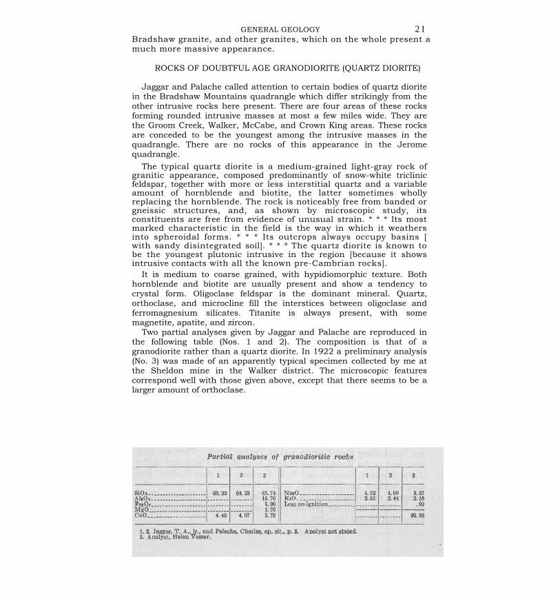
Two partial analyses given by Jaggar and Palache are reproduced inthe following table (Nos. 1 and 2). The composition is that of agranodiorite rather than a quartz diorite. In 1922 a preliminary analysis(No. 3) was made of an apparently typical specimen collected by me atthe Sheldon mine in the Walker district. The microscopic featurescorrespond well with those given above, except that there seems to be alarger amount of orthoclase.
22 JEROME AND BRADSHAW MOUNTAINS QUADRANGLES, ARIZ.
According to the quantitative system the first two analyses indicate a tonaloseand the third corresponds to an adamellose. Which of these represents theaverage composition of the intrusive rock must be left an open question.
The pre-Cambrian of Arizona contains few if any rocks of this composition,but the rock agrees closely with the intrusives of Jurassic or later age which areso abundant in the western coast region of North America. The probability isstrong that these masses were intruded in Cretaceous or early Tertiary time.
BASIC DIKE ROCKS
Basic dike rocks are not abundant in these quadrangles. There are somediorite dikes, closely affiliated with the pre-Cambrian diorite. Dikes of diabaseare found at several places. Dike rocks of camptonite were observed by Jaggarand Palache at Battle Flat, at the Creek mine (near Goodwin), near Alexandra, atthe Crooks mine, and in Crooks Canyon.
There is no direct evidence of the age of these dikes, but it is believed thatthey may well be Cretaceous or younger.
DIKES OF RHYOLITE PORPHYRY
Dikes of acidic rocks are very common. Many of aplite and more of pegmatiteare associated with the Bradshaw granite. There are also dikes of granite that isnot aplitic, as at the head of Bear Creek and Peck Canyon, which are probablyrelated to the granodiorite.
The most abundant dikes are those of rhyolite porphyry. They are of late origincompared to the other rocks of the pre-Cambrian complex, and they intersectthe granodiorite, which is believed to be of Cretaceous or later age. They occurchiefly in the western part of the Bradshaw Mountains quadrangle. Some ofthem can be traced for several miles. They usually strike north-northeast,roughly following the strike of the Yavapai schist. From the south the first onesare seen north of Copperopolis, also near the Tiptop mine and the Simpsonranch; the main belt continues northward across the granodiorite of the CrownKing district, and the dikes are found along Peck Canyon and at Turkey Creek.They are very abundant in the Hassayampa district, near Mount Union and inthe Tillie Starbuck, Senator, and N. C. 4 mines; also near Walker; and theycontinue northwestward across Hassayampa River into the Congress quadrangleand up to the Copper Basin district. They are intrusive in all the pre-Cambrianschists. The dikes are rarely more than 50 feet in width.
GENERAL GEOLOGY 23
The rock is dull white, locally porous, and usually more or lessdecomposed. I t shows small quartz and feldspar phenocrysts, alsobiotite, in a gray fine-grained or flinty groundmass. Generally it isstrongly altered by the development of sericite and calcite. None ofthese rocks can be mistaken for the rhyolite porphyry at Jerome orelsewhere in the Yavapai schist. A comparatively fresh dike nearTurkey Creek station shows fine embayed quartz phenocrysts andpartly altered crystals of orthoclase, with a little brown biotite, in amicropoikilitic groundmass of quartz and short feldspar laths,probably plagioclase.
The dike at the south portal of the Poland tunnel is a dull, light-gray, fine-grained rock with phenocrysts of feldspar. In thin section itshows many large and small crystals of feldspar, many of orthoclasebut some of andesine. There are also muscovite foils, pseudomorphicafter biotite. The groundmass is microcrystalline and consists ofquartz and feldspar. Much sericite and calcite indicate strongalteration. Entirely similar to this is a dike from the summit of theroad to the Mount Union mine from Prescott.
Another dike observed near the Tiptop shaft, in the Tiptop district,is a dull-white rock with a few phenocrysts of orthoclase, which inthin section prove to be strongly sericitized. The ground-mass ismicrocrystalline and consists of quartz and orthoclase, the latterlikewise much, sericitized. There are also pseudomorphs of muscoviteafter biotite.
Different from this is the wide dike at the Springfield mine, in theCrown King district, which intersects granodiorite. This dike consistsof a coarse porphyry with very abundant phenocrysts of quartz,orthoclase, and oligoclase-andesine in a rather coarse holocrystallinegroundmass of quartz and orthoclase. The quartz phenocrysts con-tain plentiful large fluid inclusions with bubbles and colorless cubes,probably of an alkaline chloride. A similar rock is the porphyry atCopper Basin, 12 miles west of Prescott.
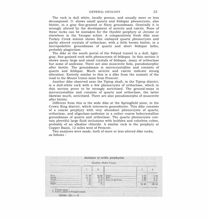
Two analyses were made, both of more or less altered dike rocks,as follows :
24 JEROME AND BRADSHAW MOUNTAINS QUADRANGLES, ARIZ.
The rocks are greatly altered; it is clear, however, that the rock from theTiptop mine is a rhyolite porphyry and that from the Poland tunnel approachesmuch more closely a trachytic composition.
The acidic dike rocks are most intimately connected with the latermineralization of the Bradshaw Mountains quadrangle. The evidence of thatmineralization points definitely to lesser depths and lesser temperatures thanthose prevailing in the mineralization that followed the intrusion of theBradshaw granite. It is concluded that the dikes were introduced after the regionhad undergone a great deal of erosion. It is also certain that the dikes are muchlater than the Bradshaw granite. As they are also later than the granodiorite wemay tentatively conclude that they were intruded in Cretaceous or Tertiary time.
I have not seen the thick dike of rhyolite porphyry in the New RiverMountains, described by Jaggar and Palache. It is situated in the extremesoutheast corner of the quadrangle, and they state that it differs but little fromthe [Tertiary] rhyolite flows of the same vicinity. No ore deposits have beendiscovered near by.
On the map (pl. 2) the quartz diorite and the rhyolite porphyry dikes areindicated as " probably Algonkian." This was the view of Jaggar and Palache.
ORE DEPOSITSMINERALS OF THE ORE DEPOSITS
The deposits of this region are not remarkable for variety and beauty ofminerals. Only 51 species have been identified.
Quartz.—As usual, quartz is the most abundant gangue mineral. In thepre-Cambrian veins the quartz has a glassy appearance and forms a coarsegranular mass. Druses and vugs as well as comb structure are absent. Locally,as near the Monarch mine, in the Black Hills, large crystals are found, but theseoccurrences rather indicate a transition to pegmatite. In much of the rock thegrains are extremely crushed, as indicated by their optical character, and full offluid inclusions, with moving bubbles which do not disappear on gentle heating.They are, therefore, not fluid carbon dioxide.
The quartz in the pyritic replacement deposits is of finer grain and lesscrushed than in the veins just described.
In the later (post-Cambrian) veins the quartz is milky white and shows littleoptical deformation. Druses, vugs, and comb structure are characteristicallypresent. The crystals are small, the largest individuals observed, in the Tiptopmine, reaching only 2 or 3 inches in length in the comb aggregates.
ORE DEPOSITS 25In some of these deposits, as at the Tillie Starbuck and Davis mines, the
quartz is fine grained. Vugs are coated with thin layers of bluish chalcedony atthe Tiptop mine. The quartz of the Springfield copper deposit at Crown Kingcontains large fluid inclusions with inclosed colorless cubes, probably an alkalinechloride.
Rutile.—Rutile is present in the ores of some pyritic replacement deposits.Calcite.—In some of the later veins calcite is not uncommon but is usually the
latest gangue mineral, covering the quartz and containing no sulphides. Itoccurs also in the pyritic replacement de-posits and in the Yavapai schist.
Siderite.—Some of the pre-Cambrian veins in the Black Hills (Shea, Yaeger,and others) contain siderite in abundance. It is of yellowish color and isassociated with tennantite, bornite, and other sulphides.
Ankerite.—The isomorphous mixtures of the carbonates of calcium,magnesium, and iron are here placed together under the term ankerite. Theyform the most common gangue mineral next to quartz and occur in practicallyall the later veins, though usually more abundant in the veins carrying muchsilver. The ankerite is dull white with a brownish or pale-pink tinge and is verycommonly intergrown with sulphides.
Dolomite.—Dolomite is found in many of the veins; it is common in some ofthe pyritic replacement deposits.
Barite.—Though not a common gangue mineral in this region, barite hasbeen observed in some silver-bearing deposits (N. C. 4, Silver Belt, andTuscumbia veins). It is associated with tetrahedrite, galena, and sphalerite.
Fluorite.—Fluorite is rare. A purple variety occurs in small quantities in theEvening Star silver vein, at Venezia; the Spring-field copper deposit, at CrownKing; and the Swallow mine, near Copperopolis.
Sericite.—In the later veins sericitic alteration of the country rock is verycommon and in places the sericite is intergrown in small aggregates with thequartz.
Adularia.—As a rule adularia is foreign to the veins in this region. It wasobserved, however, intergrown with magnetite and specularite in the unusualassociation of the Cash veins, described in some detail on page 122. The veinsare of the later type. Adularia was also noted in thin sections from theSpringfield mine.
Albite.—Albite is an abundant gangue mineral in the Springfield copperdeposit, at Crown King, where it forms a granular mass intergrown with quartz.Many of the grains show no polysynthetic twinning. This is the only occurrenceof albite noted in the ore deposits of the region.
26 JEROME AND BRADSHAW MOUNTAINS QUADRANGLES, ARIZ.
Chlorite.—Chlorite occurs in places as a product of alteration of the wall rocksbut is rarely found in the vein itself. A dark-green, almost black, dense varietywhich is rich in iron occurs in some of the pyritic schist deposits—for instance,at the United Verde—and is here properly a gangue mineral.
Epidote.—Though occurring in altered wall rocks near some veins, epidote isnot a common gangue mineral. It is associated with pyrrhotite in the Rainbowdeposit, at Turkey station, and in the Boggs mine, at Mayer, but in both of theseplaces it apparently resulted from the action of high-temperature emanations onlime-stone lenses in the Yavapai schist.
Garnet.—A grossularite or andradite garnet forms with epidote the gangue atthe Boggs mine, at Mayer. In places it occurs with magnetite in the Yavapaischist, probably as a product of igneous metamorphism.
Actinolite.—At the Boggs mine radial actinolite occurs with garnet, epidote,and sulphides.
Tourmaline.—Black tourmaline is characteristic of the emanations resultingfrom the intrusion of the Bradshaw granite into the Yavapai schist. Near thecontact much of the schist contains microscopic tourmaline, which alwaysshows its later introduction. Tourmaline is also found near the contact inpegmatite dikes and in quartz injections. The pre-Cambrian veinscharacteristically carry black tourmaline intergrown with quartz. The mineral isnot always readily recognizable; much of it appears as black or dark-green denseaggregates identifiable only under the microscope. Such tourmaline occurs, forinstance, in the Richinbar, Lehman, and Cherry Creek mines. Tourmaline isabsent from all the pyritic schist deposits and from all the later veins.
Specularite.—Specularite (hematite) is found occasionally, with magnetite, inthe pyritic schist deposits but is not characteristic. In the pre-Cambrian veins itis absent, but it appears with magnetite in the unusual Senator type of the laterveins. It also occurs as a product of oxidation of pyritic deposits—for instance, atthe United Verde, at the Cherry Creek veins, and near Copperopolis. (See pl. 15,A.)
Magnetite.—Magnetite is found at some places in the Yavapai schist, inconsiderable masses, though probably not of economic importance (p. 33). In thepyritic deposits it occurs here and there—for instance, at the United Verdemine—but is not abundant. In the veins it is absent except in those of theunusual Senator type, where it is an early vein mineral associated with adulariaand specularite.
Pyrite.—As usual, pyrite is present in practically all the deposits. It is veryabundant in the pyritic schist ores and occurs in greater or
ORE DEPOSITS 27
less abundance in all veins. It is locally crystallized in cubes and pyritohedronsand is everywhere one of the very earliest metallic minerals. Pseudomorphs oflimonite after pyrite in cubes 1 or 2 inches on a side were noted in a specimenfrom a vein near the Monarch mine, in the Black Hills.
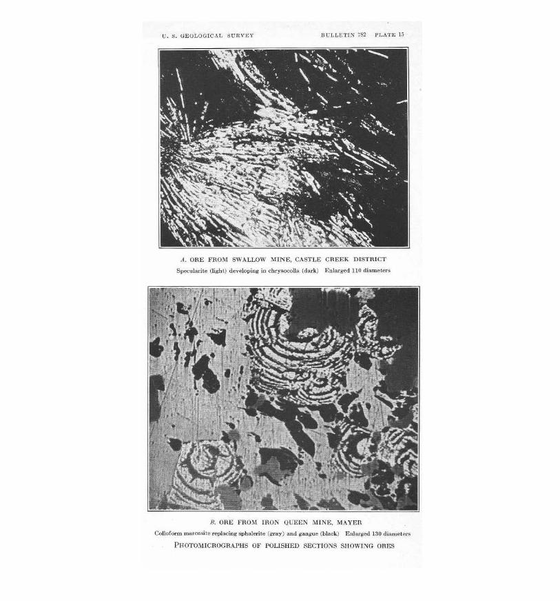
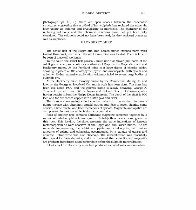
Marcasite.—The only known occurrence of marcasite is at the Iron Queenmine, where it replaces the other sulphides as rounded and reniform aggregates,evidently crystallized from a colloidal state (p. 140; pl. 15, B).
Pyrrhotite.—Pyrrhotite is rare but is found in massive form at the Rainbowdeposit, near Turkey Creek station.
Chalcocite.—As a product of sulphide enrichment by descending waters at orabove the water level chalcocite, usually in sooty or dull aggregates, is found inalmost every deposit where the primary ore carries chalcopyrite, bornite, ortetrahedrite. Few of the veins or deposits in this region show a well-definedchalcocite zone. The mineral is fairly abundant in the upper levels of the UnitedVerde mine and in a thin but well-marked zone in the Copper Chief mine, southof Jerome. Very large masses of chalcocite occur in the pre-Cambrian enrichedzone in the United Verde Extension mine, with cuprite and native copper. Heresome of it is massive and has a metallic luster. The massive form also occurs atthe Pittsburg Tunnel, on Mescal Gulch at Jerome, and at Copper Mountain,near Mayer.
Covellite.—Except in minute aggregates with chalcocite, covellite is rarely seenin the region. Very fine specimens were, however, obtained from the UnitedVerde Extension mine.
Molybdenite.—There are practically no important occurrences ofmolybdenite in the two quadrangles. Just west of the Bradshaw Mountainsquadrangle, in Copper Basin, considerable quantities of the mineral occur in oneof the deposits of the younger type in connection with granite porphyry. It ishere associated with pyrite and chalcopyrite, and shipments of the mineral havebeen made from this locality. Molybdenite is said to occur in a presumably pre-Cambrian quartz vein on a ridge west of Venezia.
Sphalerite.—The isometric zinc sulphide is one of the commonest minerals inall ore deposits in the area described, but it is rarely of economic importance. Itis present in many pre-Cambrian quartz veins; it is also common in the pyriticdeposits in schists, and zinc concentrates have been shipped from theBinghampton mine. It is abundant in the United Verde mine and is present inpractically all the deposits of the younger type, mainly fissure veins. Usually it isdark brown; more rarely, as at the De Soto and United Verde, both pyritic schistdeposits, it is of lighter color. According to V. C.
28 JEROME AND BRADSHAW MOUNTAINS QUADRANGLES, ARIZ.
Heikes,'' the shipments of zinc in crude ore or concentrates fromYavapai County amounted to 357,380 pounds in 1918, 1,717,000pounds in 1919, 1,437,296 pounds in 1920, and none in 1921, 1922,and 1923. The zinc is always a by-product.
Galena.—The lead sulphide is almost as widely distributed assphalerite. It occurs in a few of the pre-Cambrian veins and is rarelyseen in the pyritic schist deposits but is most common in the veins ofthe younger type, from which shipments of crude ore and concentratesare made in many districts. In these veins it is associated with drusyquartz, ankerite, and more rarely with barite. Galena is always one ofthe youngest ore minerals in any given association.
Shipments of lead in crude ore and concentrates from Yavapai Countyamounted, according to Heikes, to 348,389 pounds in 1918, 237,605pounds in 1919, 238,296 pounds in 1920, 172,150 pounds in 1921, 82,199 pounds in 1922, and 216,612 pounds in 1923. The lead also maybe considered as a by-product.
Argentite.—Although argentite was doubtless of common occurrencein the now largely exhausted rich oxidized silver ore, it was rarely seenduring the present examination. In some of the galena (Arizona Nationalmine) it is rather abundant, in microscopic crystals. and it was observedin a polished section of partly oxidized ore from the Cougar mine, atCrown King, as a peripheral replacement of galena and sphalerite (pl.14, B).
Stibnite.—Radial aggregates of stibnite were observed at the 76 mine,in the Tiptop district. Stibnite is also reported from a vein in the BattleFlat area and from the White Spar mine, on the west side ofHassayampa River, in the Congress quadrangle. It is confined to veins ofthe younger type associated with Mesozoic (? ) intrusive rocks.
Bismuthinite.—A specimen of bismuthinite was obtained from theSwallow mine, in the Castle Creek district, probably also one of theyounger type of deposits. It is a crystalline coarse fibrous aggregatelargely altered to bismuth ocher and surrounded by radiating quartzcrystals.
Bournonite.—The only known occurrence of bonrnonite in this area isat the Boggs mine, near Mayer, which has been idle for many years. It isintergrown with calcite in imperfect crystals a few millimeters thick andis associated with arsenopyrite and the more common sulphides. Itseems to be the latest mineral in this association. The occurrence ismentioned in Dana's " System of mineralogy."
Tennantite.—In the pre-Cambrian pyritic deposits tennantite is notuncommon, though it rarely occurs in large quantities. It is
19 U. S. Geol. Survey Mineral Resources.
ORE DEPOSITS 29
found with ankerite or siderite, locally in later veinlets and smallmasses, but nowhere in distinct crystals. It is most abundant at theUnited Verde mine, where the mineral contains a notable amount ofsilver.
Tetrahedrite.—In the later gold-silver veins tetrahedrite is of commonoccurrence, though there is rarely much of it. It is in-variablyargentiferous and in places strongly so. It usually contains somearsenic. Crystals have not been observed. Together with argentite ingalena, tetrahedrite is the source of silver enrichment by descendingsolutions. It is found in the N. C. 4 vein (with barite), practically allthe veins in the Crown King district, the McCabe vein, the Sheldonvein, and many others. The variety freibergite was identified inspecimens from the Buzzard mine and the Black Warrior and SilverPrince (Swastika mine). It is commonly associated with sphaleriteand galena (Arizona National mine). It also occurs in pyriticreplacement deposits, and here it always contains some arsenic, asat the Binghampton, Kay, and other deposits. Considerable amountsof tetrahedrite ore have been shipped from the Shea vein, a pre-Cambrian deposit.
Arsenopyrite.—Many, if not all, of the pyritic schist deposits con-tain a little arsenopyrite, in places well crystallized (Boggs mine). TheUnited Verde, Binghampton, Blue Bell, and De Soto are among themines where this mineral was noted. Larger aggregates of massivearsenopyrite occur in the Blue Dick, Mark Twain, and Buzzard veinsand may possibly be of some economic importance. Arsenopyrite isalso found in some of the veins of the later series, as at Tiptop,Sheldon, and other places.
Chalcopyrite.—Chalcopyrite is the most common and most valuableore mineral of the region. It is of universal occurrence in the pyriticschist deposits, appears here and there in the pre-Cambrian quartzveins, and is almost invariably present in the veins of the later series,though here not of much economic value. In the lead-silver veins withbarite or ankerite gangue it is scant or absent, and its place is takenby tetrahedrite. It nowhere shows crystal forms.
Bornite.—Bornite is not a common mineral in this region. Finespecimens of the massive mineral were collected from the ore pile ofthe Yaeger mine, near the road from Prescott to Jerome. A littlebornite was seen in polished sections from the Tiptop mine. It hasbeen observed in the United Verde mine and in the Cherry Creekveins.
Pyrargyrite and proustite Both ruby-silver minerals were ob-served, proustite perhaps more commonly than pyrargyrite. As aprimary mineral proustite was noted in the Davis and Tillie Star-buckmines, on Mount Tritle, and at a few other places. Pyrargyrite wasnoted in specimens from the Thunderbolt mine, in Black Can-
30 JEROME AND BRADSHAW MOUNTAINS QUADRANGLES, ARIZ.
yon. Ruby silver is commonly reported as having occurred more orless abundantly in many of the rich oxidized silver ores formerlymined—for instance, at the Tiptop, Tiger, and other places where it isnow absent in the primary ore. It is believed that these minerals arein part of supergene origin (deposited by descending waters). No well-developed crystals were observed.
Gold.—Native gold of ordinary fineness (about 0.850) is found in theplacer deposits along recent streams. Coarse gold of deep yellow coloris often seen in the pre-Cambrian quartz veins, particularly at theMonarch mine, in the Black Hills. In the pyritic schist deposits visiblegold is apparently absent, though it has been set free in many of theoxidized outcrops. In the veins of later type free gold is rarely seen,except in the zone of oxidation. Coarse gold appeared with sulphidesin the Crown King mine, but in most places it is probablydisseminated in the sulphides in microscopic or submicroscopicparticles.
Silver.—Native silver occurs so far as known only in the partly orwholly oxidized silver ores of the later veins (Arizona National mine). Itis reported from almost all the mines noted for such rich ores.
Copper.—Native copper is not uncommon in the oxidized ores of allkinds, particularly in the pyritic schist deposits. It is particularlyabundant in the United Verde Extension mine, where it occurs withchalcocite and cuprite.
Cuprite.—Cuprite is often found in the oxidized ores of copperdeposits, particularly in those of the pyritic bodies in schist. It occursabundantly and well crystallized, in part as chalcotrichite, in theUnited Verde Extension mine.
Copper carbonates.—Malachite and azurite are common, thoughrarely in quantity, in the oxidized ores, particularly in those of thepyritic schist deposits.
Chrysocolla.—The oxidized ores of the veins in the Castle Creekdistrict, which is situated in the "torrid zone," carry characteristicallyblue chrysocolla, copper pitch ore, native copper, limonite, andsecondary specularite. Chrysocolla is the important ore mined in thegravel of the Dundee-Arizona mine at Jerome.
Anglesite and cerusite.—As oxidation products of galena angle-siteand cerusite are not uncommon, though rarely of any economicimportance. Anglesite on galena was particularly noted in a specimenfrom the Big Lead vein, at Copperopolis.
Vanadinite.—Vanadium minerals are rare; one occurrence ofvanadinite is reported from a prospect just north of the Silver Beltline, at Humboldt.
Wolframite.—Tungsten minerals are rare in this region. They havebeen found thus far only in the Tiptop district (p. 180), where
ORE DEPOSITS 31
the tungstate occurs in brown prisms as the earliest mineral in silverveins of the later type. The material has not been analyzed, but itsappearance points to hiibnerite rather than to wolframite.
Limonite.—Limonite, generally earthy, is common in the oxidized zone.Rarely it is accompanied by pyrolusite or wad.
Kaolin.—Kaolin is naturally present in much of the oxidized ore. It wasnever observed as a constituent of primary ore.
Gypsuan.—Gypsum is often found in the oxidized zone. It is abundantin the decomposed dikes of the United Verde mine.
GENERAL CLASSIFICATION
The discussion of the mineral deposits in the region is naturallylimited to ore deposits, as the nonmetallic minerals are of little value. Alittle limestone may be used here and there for burning, and the bandedtravertine, or " onyx marble," in the Quaternary hot-spring deposit atMayer has been employed to some extent for flux and ornamental stones.Of building stones there is a good supply of granite and locally of rhyolitetuff, but there is little demand. A large deposit of sodium sulphate occursin the Verde lake beds near Camp Verde and has been described by W.P. Blake and O. P. Jenkins. (See p. 14.)
The ore deposits may be divided as follows :Pre-Cambrian ore deposits :
Pyritic copper deposits in schist.Magnetite deposits.Contact-metamorphic deposits.Gold-quartz veins.Gold-quartz tourmaline replacement deposits.Quartz veins carrying silver, copper, and lead.
Later gold and silver veins (Mesozoic? or early Tertiary?).Quartz veins carrying gold and silver.Silver veins :
Veins with barite gangue.Veins with quartz gangue.
There are no ore deposits in the region to which an age later than thatof the Tertiary volcanic flows can be assigned.
PRE-CAMBRIAN ORE DEPOSITS
The evidence for the age of the deposits listed as pre-Cambrian is inpart direct and positive, in part indirect. In the Jerome district thePaleozoic sediments cover the oxidized and chalcocitized pyriticreplacement deposits, and there is no evidence of any mineralization ofthe limestones. In the Cherry Creek district the quartz veins do notpenetrate up into the Paleozoic basal beds. In the Bradshaw Mountains quadrangle the evidence is not so positive,owing to the absence of Paleozoic beds, but the character
68508—26 4
32 JEROME AND BRADSHAW MOUNTAINS QUADRANGLES, ARIZ.
of the deposits themselves is clear enough. They are of a deep-seated type, theyare in part identical in genesis with those of Jerome and Cherry Creek, andtheir relationship with the Bradshaw granite is too evident to be overlooked.
The deposits have this in common—that they were formed long before thedevelopment of the pre-Cambrian peneplain upon which the Paleozoic bedswere laid down. Their present outcrops are in many places at or close to thatpeneplain, the development of which was not accompanied by anymineralization except oxidizing and enriching processes. A great thickness, inplaces probably many thousand feet, was eroded before the present outcropswere exposed to daylight.
PYRITIC COPPER DEPOSITS IN SCHIST
GENERAL CHARACTER AND FORM
The pyritic copper deposits are the most valuable in the region and haveproduced far more than all other deposits put together, the combined value ofthe output certainly being above $130,000,000. They are replacement depositsin schist and contain pyrite, chalcopyrite, sphalerite, arsenopyrite, andtetrahedrite or tennantite in a gangue of quartz, dolomite, ankerite, and sericite.The replaced rocks may be rhyolite schist, greenstone schist, biotite schist, orchlorite-sericite schist of probably sedimentary origin. The form is tabular,lenticular, or more or less rudely cylindrical. The principal deposit at the UnitedVerde mine (fig. 4) is a steeply dipping cylindrical body 700 or 800 feet indiameter extending down to a depth of 2,400 feet, or 3,100 feet counted fromthe level of the pre-Cambrian peneplain; that of the United Verde Extension is asmaller body, gradually tapering, greatly enriched by pre-Cambrian descendingsurface waters. The deposit at the Blue Bell includes a number of thin, in partoverlapping lenses which have been followed down to a depth of 1,500 feet andwhich are traceable for 1,600 feet horizontally. Similarly the De Soto depositconsists of seven over-lapping lenses of tapering form, most of them coming to apoint 900 feet below the outcrop.
The Binghampton mine has three lenses 10 to 15 feet in maximum width,one of which, at least, is 100 feet long and extends down to the 600-foot level.
The mineralization tends to follow the schistosity, which is pre-served inmuch of the ore. There is almost everywhere strong evidence of crushing andfracturing after the deposition of the pyrite, and the chalcopyrite in many placesoccupies the fractures.
The ores contain as much as 10 per cent of copper, though most of the mineshave yielded ore containing from 3 to 5 per cent. In places, as at the UnitedVerde, there are large masses of pyrite with
ORE DEPOSITS 33
very little chalcopyrite in which the copper ores occur as shoots that follow theschistosity. There are also lenses and masses of slightly mineralized schist andof strongly silicified schist.
In the Jerome quadrangle the deposits center at Jerome (see pl. 4), thoughthere are also scattered occurrences of somewhat mineralized schist in thecentral part of the Black Hills, along their western foothills and the north edge ofLonesome Valley.
In the Bradshaw Mountains quadrangle most of the deposits follow theeastern schist belt by Copper Mountain, Blue Bell, and Black Canyon and downto the mouth of Agua Fria Canyon. A few deposits are also found in the westernschist belt, among which that of the De Soto mine is the most important.
CHARACTER OF REPLACEMENT
The raw material on which the metal-bearing solutions worked waseverywhere schist. In part the rocks were chlorite-sericite schists of uncertainorigin; in large part they were schistose rhyolite porphyry, as at the UnitedVerde, Binghampton, and Blue Bell (in part), and probably also at the Howardcopper mine. In part they were of undoubted sedimentary origin, as at theUnited Verde and the Blue Bell (in part). The ores have in many places inheritedthe schistose structure, but no schistosity has been superimposed upon them.The ores are similar in character throughout.
The action began by replacement of the schist minerals by quartz andcarbonates; the carbonates are in part calcite, but more commonly dolomite andankerite ; siderite is not common. The result is a quartz mosaic of varying grain,the individuals being rarely crushed or optically deformed. The carbonates are inthe main later than the quartz, but deposition of gangue minerals accompaniedthe sulphides also. Toward the end—that is, with the deposition of tetrahedriteand tennantite—little quartz but a considerable amount of dolomite wasdeposited. Though many ores contain some sericite, not much of this mineralwas formed, and there is no extensive sericitization such as is so common inother deposits. A dark-green chlorite with fairly strong birefringenceaccompanied the deposition of the sulphides in many places, particularly justbefore the introduction of chalcopyrite. This chlorite is apparently a variety richin iron, allied to prochlorite or aphrosiderite.
The final result is a mosaic of quartz and dolomite or a similar carbonate withor without chlorite, in which are embedded cubes and anhedrons of pyrite andanhedrons of other sulphides. The sulphides are deposited in unvarying order,the later replacing the earlier sulphides or the gangue.
34 JEROME AND BRADSHAW MOUNTAINS QUADRANGLES, ARIZ.
Arsenopyrite in scattered crystals is probably the earliest sulphide, though itsage relatively to pyrite is not always easy to determine. It is invariably present,though in very scant amount.
Pyrite came next, in small cubes or anhedrons. In places quartz seems toradiate from it in straight or curved streamers. The deposition of pyrite wasalmost everywhere followed by the fracturing and shattering before mentioned,which really was the effect of closely spaced jointing, locally in three directions.
Magnetite, replaced in part by specularite, is normally absent but appears insome parts of the United Verde ore body. Here these minerals followed the pyriteand were replaced by later sulphides. Benedict 20 suggests that their presencemay have been caused by a heat wave produced by the many dikes of dioriteporphyry that were injected into the deposit during the mineralization.
Sphalerite, closely followed by chalcopyrite, was next introduced. It replacespyrite extensively and is present in all deposits; it is very abundant in certainparts of the United Verde mine. The sphalerite is usually of light-brown color,but in slides from the United-Verde mine it is pale yellow or gray with a darkrim, which is in no way indicated in the corresponding polished section. There isno disseminated chalcopyrite in the sphalerite. The mineral was depositedaround the. periphery of the pyrite and also replaced it, so that a mass of thezinc sulphide may contain many rounded residuals of pyrite.
In some specimens (pl. 10, A) veinlets of quartz with sphalerite and a littlechalcopyrite cut across the products of the earlier mineralization. In the samespecimens there are still later veinlets of calcite with a little sphalerite andchalcopyrite.
A streaky or banded appearance is common and is determined by pyrite,sphalerite, or chalcopyrite following the lines of schistosity.
The chalcopyrite followed the sphalerite and replaced the earlier minerals ofgangue and sulphides. It is found mainly in the shattered pyrite, replacing itand filling the interstices (pl. 11, A ) . In many places where it occurs inabundance it is associated with the confused radial masses of iron chlorite andmay replace that mineral.
Galena occurs scantily in small scattered grains and seems to have followedchalcopyrite and tennantite.
One of the last minerals to form was tennantite (United Verde) or arsenicaltetrahedrite; it replaced any of the older- minerals and occurs in small amountsin almost every one of the deposits. Frequently it is seen in veinlets cuttingacross the deposits formed by the older mineralization and is associated withdolomite.
20Benedict, P. C., unpublished thesis, Massachusetts Inst. Technology, 1923.
ORE DEPOSITS 35
ORIGIN OF THE REPLACEMENT DEPOSITS
There is some difficulty in interpreting the origin of these pyritic replacementdeposits. Their great similarity is striking, as is the fact that they can not beconnected with any definite rock. Clearly the schists and the supracrustaligneous rocks they contain have nothing to do with the origin of the deposits,whose wide distribution and similar character would seem to indicate an originfrom some deep-seated source. There is nothing to connect them definitely withthe Bradshaw granite or its dioritic facies, though at the United Verde the dioriteis the latest intrusive, having been injected after the schistosity had developed. Atother places, however, there is no granite or diorite in the vicinity of thesedeposits. The pipelike form of the principal deposit, that of the United Verde mine(fig. 4), and the fact that it persists down to a level at least 3,200 feet below thepre-Cambrian peneplain certainly indicate mobile solutions ascending undertremendous pressure.
At first glance the mineralization gives no clue to the origin, but the absence ofstrongly marked sericitization and the presence of an iron-rich chlorite point to ahigh temperature. Certainly the de-posits were not derived from thedifferentiation products of the Bradshaw granite, like the tourmalinic gold quartzveins. Probably they came from greater depth, perhaps from the granitic magmabut from levels where mineralizers like fluorine, boron, and phosphorus had notyet separated to any great degree. These magmatic fluid emanations penetratedthe rocks along lines or channels of weakness and diffused through the rocks ontheir upward path. They deposited their load of sulphides and quartz and rapidlytook up the waste products of replacement, thus changing their compositionfrom magmatic fluids to mixed fluids, which probably did not differ greatly fromsome of the deep-seated thermal springs that now in many places on the earthdischarge their waters at the surface.
MAGNETITE DEPOSITS
At several places in the region the schists contain magnetite, here and thereso much that they may be considered iron ores, though it is unlikely that theywill ever be utilized. The gangue is quartz and silicates, so that they are notsuitable for flux. These magnetite ores are generally banded and locallycontorted and alternating with red jasper, and they seem to be of sedimentaryorigin. In fact, some specimens found near Copper Mountain and also at theUnited Verde mine are very similar to the Lake Superior iron formations. Jaggarand Palache describe material from a place 2 miles southwest of Buena,which is essentially a banded quartzite with small amounts of
36 JEROME AND BRADSHAW MOUNTAINS QUADRANGLES, ARIZ.
garnet, epidote, hornblende, and tourmaline and streaks of magnetite. Here themagnetite makes up about 50 per cent of the rock.
Another occurrence is 11/4 miles north of White's ranch, in Minnehaha Flat,where a mica schist is rich in sharply crystallized garnet and in magnetite.
Other very similar occurrences of banded magnetites were found during thepresent examination on Turkey Creek 1 mile southeast of Turkey Creek stationalong the road and in Black Canyon 1 mile south of the Howard Copper Co.'sproperty. At both places the magnetite is associated with quartzite and containssiliceous material.
Many of the Yavapai schists contain metacrysts of magnetite with tails ofquartz (pl. 5, A) and tourmaline, and it is thought that these two minerals,which are distinctly later than the general schistosity, were introduced bysolutions emanating from the Bradshaw granite at the time of its intrusion.Just what part this metamorphism played in the development of the magnetiteschists is not certain. It is certain, however, that indications of igneous meta-morphism appear in the schists at many places, especially where they containcalcareous material. In fact, it seems clear that almost the whole of the Yavapaischist body has been more or less penetrated by granitic emanations.
CONTACT-METAMORPHIC DEPOSITS
The deposit on Turkey Creek known as the Rainbow lode (p. 154) bears theearmarks of a lens of contact-metamorphic limestone. It is a lenticular body ofpyrite, pyrrhotite, and a little chalcopyrite, with an abundant gangue of coarseepidote and residual calcite. There is also a little deep-brown biotite andmagnetite. At the Blue Bell mine the schists are calcareous and contain smalllenses of limestone. I understand that Prof. Charles P. Berkey, who rendered areport to the company on the rocks of the deposits, found some garnet, whichhe regards as part of the schist series and as having no direct relation to thedeposit.
Near Mayer are the old pyritic schist deposits of the Hackberry, Boggs, andIron Queen mines, all now closed and inaccessible. In the dump of theHackberry mine, besides prevailing chloritic schist, was found granularmagnetite with radial amphibole. At the Iron Queen mine the chloritic schistcontains thin bands of andradite or grossularite garnet with a little magnetite.At the Boggs mine specimens were obtained showing yellow garnet, actinolite,epidote, and residual calcite; all these silicates have replaced the quartz mosaicof the schist. The mosaic and the calcic silicates are replaced by sphalerite,chalcopyrite, and, magnetite. It is thought that this material represents a type ofcontact-metamorphic
ORE DEPOSITS 37
ore which was already in existence when the main pyritic replacement depositin chloritic schist was formed. In other words, the schist contained thinlimestone lenses which were metamorphosed by granitic emanations, and laterthe pyritic ores, on which the mine was worked, came into existence.
A specimen of apparently amphibolitic wall rock from the Henrietta mine, 2miles north of Mayer, proved to be a quartz mosaic with some albite whichcontained much diopside, some magnetite, and residual calcite—evidently acontact-metamorphic product of an original calcareous rock.
In conclusion, the widespread soaking of the Yavapai schist in graniticemanations is evident. It is believed that all the scattered tourmaline in the schisthas this origin. Valuable deposits would probably have been developed had theoriginal sediments contained more than a few thin lenses of limestone.
GOLD-QUARTZ-TOURMALINE REPLACEMENT DEPOSITS
The absence of tourmaline from the normal type of pyritic re-placement orescarrying copper has already been noted. There is one deposit, however, of theunusual type containing gold, quartz, and tourmaline.
The Iron King mine (p. 127), in the Yavapai schist about a mile west of theHumboldt smelter, has been worked for gold and silver and is said to containconsiderable low-grade ore. The deposit forms a series of overlapping lenses, inall 75 feet wide, in which the schist is highly silicified and banded by theintroduction of fine-grained sulphides, mainly pyrite, with a gangue of granularquartz, tourmaline, and some dolomite. The sulphides are, in order of age,arsenopyrite (oldest), pyrite, sphalerite, and galena. Intergrown with thesulphides are abundant prisms of bluish tourmaline.
This deposit is regarded as of the same age as the gold-quartztourmalineveins and is believed to have been formed by the emanations from the granite.
GOLD QUARTZ VEINS
GENERAL
CHARACTER
There are many gold quartz veins in this region. Among them there are anumber which stand out with rather definite characteristics. They occur ingranite or schist but not, so far as known, in granodiorite; the quartz is massive,without druses; a rude banding of the various constituents is locally apparent,but there is no crustification. The mineralization is simple; besides predominat-ing quartz there may be a little ankerite or siderite; tourmaline has
38 JEROME AND BRADSHAW MOUNTAINS QUADRANGLES, ARIZ.
been found so often that it is considered a typical though usually scant ganguemineral. The quartz is invariably strained and crushed and occurs in lensesalong the course of the vein. The sulphides consist of pyrite, chalcopyrite,sphalerite, and galena, but they occur scantily. Free gold is present, much of itin visible particles. The alteration of the country rock is slight. In regions wherethe Paleozoic beds cover the pre-Cambrian, these younger beds are barren,showing no mineralization whatever.
These veins have been classed as of pre-Cambrian age, and their geneticconnection with the intrusion of the Bradshaw granite may be regarded asproved. Besides the structure, which points unerringly to deep-seatedconditions, the presence of tourmaline points directly to the granites. Theintrusion of this rock was accompanied by boron emanations, which producedtourmaline that is not only disseminated in the schists near the contact but alsois characteristic of the many pegmatite veins that are found along the contacts.The pegmatites, however, form a distinct and separate unit, and no transitionsbetween pegmatites and gold quartz veins have been found.
PRODUCTIONUndoubtedly the disintegration of the gold quartz veins has contributed a
considerable amount of the coarser free gold to many of the placer deposits. Thispart of the production has been considerable but is difficult to estimate, foryounger veins have also yielded much placer gold. The gold occurs in smallshoots, and few of these pre-Cambrian veins have been worked continuouslyand profitably. Many of them are certainly poor. The Richinbar mine, in AguaFria Canyon, has perhaps yielded more than any other deposit. The CherryCreek veins, including the Monarch, have contributed some, and the Mesa vein,on upper Bigbug Creek, was a noted producer. Many others have been workedintermittently, at first by arrastres using the ores in the oxidized zone, whichwere richer owing to the setting free of the fine gold in the sulphides throughdecomposition by surface waters. Silver is present besides gold.
The total production from these veins in this region has probably notexceeded $1,000,000.
DISTRIBUTION
In the Jerome quadrangle these veins occur north of Lonesome Valley ("Peters silver mine "), in the Coyote Hills in the same valley (p. 102), in the CherryCreek district (p. 103), and east of Prescott in the southern foothills of LonesomeValley (p. 108). In the Bradshaw Mountains quadrangle they are present at theMesa mine, near the head of Bigbug Creek (p. 136) ; at the Ruth mine, on theJersey
ORE DEPOSITS 39
Lily road (p. 116) ; at the Jersey Lily mine (p. 117) ; on the divide between BlackCanyon and Bumblebee Creek; along the road to Can-yon, south of Bumblebee;at the Richinbar mine (p. 157) ; at the Button and Boaz mine, south ofMinnehaha Flat (p. 177) ; and at the Lehman mine, north of Copperopolis. Withfew exceptions, the veins are not scattered, are not contained in any particularrock, and do not form continuous belts, except perhaps at Cherry Creek.
STRIKE, DIP, AND THICKNESS
The strike and dip of these veins are irregular; probably the most commonattitude is a northerly strike and steep dip. The Cherry Creek deposits generallydip at moderate angles to the west. The quartz occurs in lenticular shoots with amaximum width of 10 or 15 feet, usually much less. The country rock next tothe veins is in places sheared, as at the Ruth mine (p. 116).
MINERALIZATION
The principal features of the mineralization have already been mentioned.There seem to be two classes of deposits—one with bunches and pockets of freecoarse gold and another in which the principal value lies in the sulphides, whichcarry finely disseminated gold. Generally some cyanide process has beenapplied after the workings have descended below the water level. The ores, asidefrom rich bunches of free gold, generally average below $20 a ton in value. Someof the Cherry Creek mines, for instance, in 1909 yielded amalgamating oreaveraging 1 ounce in gold and about half an ounce in silver to the ton, besides200 pounds of concentrates that contained 40 ounces in gold and 115 ouncesin silver to the ton. In other years the ore produced would average about $12 aton. The principal difficulty appears to be the small size and irregularity of theshoots. The tourmaline is locally abundant, as in the deposits at the Ruth mineand east of Prescott on the road to Dewey. But more commonly the tourmalineoccurs as very fine-grained black streaks in the quartz which can be identifiedonly under the microscope. With a hand lens they look like streaks of chlorite.The wall rock is rarely extensively altered to sericite. Siderite and ankerite occurin smaller amounts.
UNUSUAL TYPES OF PRE-CAMBRIAN VEINS
In the Black Hills are found several veins that differ markedly from those justdescribed. They are represented by the Shea mine (p. 92), the Brindle Pup andMingus Mountain mines (p. 100), the Yaeger mine (p. 98), and the Shylockdeposit (p. 99). It can
40 JEROME AND BRADSHAW MOUNTAINS QUADRANGLES, ARIZ.
not be doubted that these veins are of pre-Cambrian age, for the absence of anykind of mineralization in the near-by Paleozoic strata is striking. They strike inan easterly direction and generally dip south or southeast at angles of 40° to60°. The width reaches 10 feet, and the ore occurs in lenticular masses. Most ofthe veins carry argentiferous tetrahedrite or tennantite, some of it containing100 ounces of silver to the ton. The quartz is coarse and massive; there isalways some siderite or ankerite and sulphides like arsenopyrite, pyrite, zincblende, galena, and bornite, in places rudely banded but nowhere crustified.
In the Yaeger mine there are also some calcite, hematite, chlorite, andepidote, though the epidote may not be directly connected with themineralization. The country rock may be granite, granite porphyry, diorite, orgreenstone schist. Close to the vein the Shea mine at least shows markedsericitization. Possibly this mineralization had some genetic connection withthe diorite intrusions. At any rate it was later than the granite and pre-Paleozoic.
The Yaeger mine, in the western foothills of the Black Hills, is easily the mostprominent. The deposit contained an extensive shoot of high-grade bornite ore,with some secondary chalcocite and oxidized copper minerals, and it is said tohave yielded about $1,000,000 in copper, $50,000 in gold, and $77,000 insilver, which is more than can be credited to any other pre-Cambrian depositoutside of the pyritic replacement group represented by the United Verde,United Verde Extension, Blue Bell, and others.
In the Bradshaw Mountains quadrangle there are some veins probably also ofpre-Cambrian age that differ markedly from the ordinary type. Like theexamples from the Black Hills above mentioned they carry silver, though notinvariably copper. The most prominent examples of this class are the veins inthe Blue Dick, Mark Twain, and Buzzard mines, in the Hassayampa district (p.117) . It is indeed not certain that these veins are of pre-Cambrian age, thoughthe massive quartz, which under the microscope proves to be greatly crushedand deformed, points strongly to such a conclusion. The veins strike north anddip east and are contained in a dull greenstone. They carry quartz with mucharsenopyrite, minor amounts of other simple sulphides, and locally alsotetrahedrite rich in silver. The oxidized ore was very rich, and the Blue Dickdeposit has produced ore to a value of at least $200,000. The Dunkirk deposit,close by (p. 119), may belong to the same group ; the Jersey Lily, some distancetoward the west, is a pre-Cambrian gold-quartz deposit.
Among the pre-Cambrian deposits should also be classed the massivesiderite, pyrite, magnetite, and chalcopyrite ore that occurs on
ORE DEPOSITS 41
the Fairview claim, on the trail from Crown King to the Peck district. A similarore was observed at the Blue Bird mine, on the old road between the twodistricts. I believe that these siderite ores form lenticular masses in the schist.Little is known regarding the extent of the deposits.
LATER GOLD AND SILVER VEINS
GENERAL FEATURES
Besides the certainly pre-Cambrian quartz veins and pyritic replacementdeposits there are in this region a great number of other quartz veins that carrychiefly gold or chiefly silver or considerable quantities of both metals. They arewidely scattered in the Bradshaw Mountains quadrangle but absent from theJerome quadrangle, except for some small veins in schist on the road fromPrescott to Walker. In the Bradshaw Mountains quadrangle they are absentfrom the eastern half, but in the western part they begin near the southernboundary, in the Tiptop, Humbug, and Copperopolis districts, and continueafter a short interval northward through the Crown King, Turkey Creek, Bigbug,Walker, Groom Creek, and Hassayampa districts, nearly to the north boundaryline. The veins in the Hassayampa district continue beyond the westernboundary and across Hassayampa River into the Congress quadrangle, endingon the north at Copper Basin. Probably they will also be found in the centralpart of the Congress quadrangle, about the Congress and Octave mines.
The deposits are typical fissure veins, usually straight and narrow, with well-defined walls. The strike is usually north, northeast, northwest ; the veins, withfew exceptions, have a steep dip. The gangue is as a rule mainly quartz of milkycolor and drusy structure that in places grades into well-defined combstructure. Ankerite is present in most of the veins, and barite is often found inthe silver veins. Fluorite is found in three places, albite in one, adularia in one.High-temperature minerals are absent, except for magnetite and specularite,which are developed, apparently abnormally, in the Senator group in theHassayampa district. The sulphides occur in no great volume and comprisearsenopyrite, pyrite, sphalerite, chalcopyrite, galena, commonly tetrahedrite,and less commonly ruby silver; in the Tiptop district wolframite occurs as theearliest mineral. Sericitization and carbonatization of the country rock is therule. The base metals are of little value except as by-products. Free gold ispresent in the oxidized zone, together with native silver, argentite, andoccasionally ruby silver, with more or less of the chloride or bromide of silver. Inthe primary ore free gold is probably everywhere present, but morecommonly in intimate and micro-
42 JEROME AND BRADSHAW MOUNTAINS QUADRANGLES, ARIZ.
scopic intergrowth with the sulphides than as visible particles, so that of lateyears the cyanide process has usually been employed in the treatment. Thegalena carries included grains of argentite.
It is impossible to deny that all these veins are very closely related in origin,irrespective of their varying contents in gold or silver. Their structure andmineral composition point clearly to their being a product of the intermediatezone, though in one or two places there may be indications of highertemperature and though a few of the deposits approach in character thoseformed near the surface.
In the main they certainly bear the characteristics of deposits of themesothermal (intermediate) zone,21 formed by thermal solutions ascendingtoward the surface. Their characteristics differ markedly from those of the veinsthat have been determined as having a genetic connection with the Bradshawgranite. The latter were formed long before the great pre-Cambrian erosion andthe development of the pre-Cambrian peneplain. There is no direct evidence ofthe age of the later veins, for in the region where they abound there are noPaleozoic rocks.
Three groups of these veins—those in the Groom Creek Walker, and CrownKing areas—are very clearly related areally to the small granodiorite intrusionsdescribed above, as has already been pointed out by Jaggar and Palache.However, there are many districts far distant from these areas in which this veintype is developed as characteristically. The veins are found in granodiorite, ingranite, or in Yavapai schist of any type.
A few of the veins follow basic lamprophyric dikes—for example, the MountUnion and Crooks veins—but this is evidently exceptional. The one rock that isuniversally present is rhyolite porphyry (p. 22), in dikes that range from a fewfeet to 200 feet in thickness. These dikes accompany the mineralized rock in alldistricts and traverse the whole western part of the quadrangle, beginning nearCopperopolis and continuing northward, some short, some traceable for mileswith a general northerly or northeasterly trend. It has already been explainedthat these dikes were in all probability intruded. after the development of thepre-Cambrian peneplain, which is not likely to have been more than 500 or 1,000 feet above the present highest points in the quadrangle. If we add a scant 2,000 feet for the Paleozoic cover it is fair to conclude that these veins were formedunder 3,000 or 4,000 feet of rocks, at most. The dikes described are surelyearlier than the late Tertiary volcanic rocks in the region, and they are hereregarded as probably late Mesozoic or early Tertiary. What part the granodioritehas played in the later mineralization
21Lindgren, Waldemar, A suggestion for the terminology of certain mineral deposits :Econ. Geology, vol. 17, pp. 292-294, 1922.
ORE DEPOSITS 43
may be left undecided. This rock also is here regarded as Mesozoic orearly Tertiary but of a decidedly earlier epoch than the rhyoliteporphyries, which cut the rocks of every other type except the Terti-ary lava.
This remarkable system of dikes, without the presence of largerintrusive masses of the same type, stands unique, at least in my ex-perience, in its clearly manifested genetic connection with an impor-tant system of veins. Almost all the dikes are strongly sericitized, andmany of them are impregnated with pyrite and a little calcite ordolomite.
Jaggar and Palache estimated the total production of the depositsin the Bradshaw Mountains quadrangle to the end of 1901 to be $9,500,000, and almost the whole of this sum was derived from the laterquartz veins. At that time the pyritic replacement deposits had notbeen worked extensively, and a scant million dollars is a liberalestimate for the pre-Cambrian deposits in this quadrangle. I thinkthat the estimate referred to is too moderate and that the actualfigures are almost twice as large as the amount indicated.
The silver veins, the gold veins, and those containing both gold andsilver are not separated in distinct areas. There seem to be all kindsof transitions between them, and it looks as if they were simply phasesof one mineralization.
SILVER VEINS
The silver veins are widely scattered. They occur in the Hassa-yampa, Bigbug, Peck, Black Canyon, Turkey Creek, Tiger, Pine Grove,and Tiptop districts.
The silver veins may be divided into those containing mainlyankerite or allied carbonates and barite as gangue, with more or lessquartz, and those containing mainly quartz gangue. In both classesthe oxidized zone has yielded most of the ore.
VEINS WITH BARITE
The veins of the first class are poor in pyrite but contain galena,sphalerite, and tetrahedrite. The structure is crustified with manyrugs, but the minerals are fairly coarse in texture. Ankerite orsiclerite usually appears next to the walls and .the sulphides in thecenter. The galena contains inclusions of argentite and the tetra-hedrite is everywhere argentiferous. Ruby silver (pyrargyrite) occursmore rarely and is in many places probably supergene. The mostcommon supergene and enriching minerals are argentite, cerargyrite,bromyrite, and native silver, besides oxidized copper and leadminerals. In most of the deposits the rich oxidized zone has beenmined and work was suspended when it reached the water level
44 JEROME AND BRADSHAW MOUNTAINS QUADRANGLES, ARIZ.
or, at a short distance below this level, the primary sulphides. However, fromthe Arizona National and the Black Canyon veins much sulphide ore, perhapsenriched to some degree, has been shipped. The rich oxidized ores have beenamalgamated or cyanided; the sulphide ore is shipped crude or concentrated.Much of the oxidized ore carried $50 to $100 to the ton. The primary ores aremuch poorer:.
Among the notable mines on deposits of this type are the Silver Belt, ArizonaNational, and adjacent properties in the Bigbug district (p. 128) ; the Peck andSwastika, in the Peck district (pp.161—162); the N.C. 4, in the Hassayampadistrict (p. 117) ; and the Tuscumbia, in the Bradshaw district (p. 176). Dikesof rhyolite porphyry occur in all the districts. They are abundant near the N. C.4 and Peck mines.
VEINS MAINLY WITH QUARTZ GANGUE
The silver-quartz veins are narrow, with comb structure or drusy quartz andin places some ankeritic carbonates. They contain more pyrite than the bariteveins, also a little chalcopyrite, rarely tetrahedrite. Here and there a comb ofquartz crystals coats the walls.
Among these veins may he mentioned that worked in the Tiger mine (p.172), in the district of the same name. It is contained in granodiorite. Here thequartz attains a width of several feet and it is less drusy than elsewhere. Thesulphides are sparse and comprise pyrite, sphalerite, galena, and tetrahedrite.The oxidized ore was very rich, much of it containing $100 to the ton. Deeperand poorer ore, said to have yielded 0.07 ounce of gold and 22 ounces of silverto the ton, was mined in 1910. In depth the ore appears to be of decidedly lowergrade.
East of the Tiger is the Gray Eagle lode, which in its southern part containsmuch gold, but its northerly extension carries more silver. Oxidized oresenriched by horn silver and argentite were shipped in 1922. One lot of 2 tonscontained $2 in gold and 454 ounces of silver to the ton and 15 per cent of lead(p. 175).
The Tiptop vein (p. 180) is another old-time producer of somewhat unusualtype. It is at most 6 feet wide. The quartz shows coarse comb structure nearthe walls but is finer grained in some parts, and the druses are coated withchalcedony. The scanty ore minerals consist of wolframite (earliest and alongthe walls), arsenopyrite, pyrite, sphalerite, bornite, and galena, formed in theorder given. Here too the oxidized ore was very rich, and work was stopped atthe 800-foot level.
There remain to be mentioned the flat veins of the Black Canyon district, notfar from Turkey Creek station. These narrow veins dip 20° to 35° in anydirection and usually are contained in Yavapai
ORE DEPOSITS 45
schist. The Thunderbolt and the Howard Silver are the principal producers (p.158). The War Eagle, Bueno, Goodwin, and Morgan veins, in the Turkey Creekdistrict, are of the same or similar type.
Rhyolite porphyry dikes occur near the Morgan mine and at the Tiptop mine.GOLD AND GOLD-SILVER VEINS
PROPORTION OF GOLD TO SILVERBy far the greater number of veins in the Bradshaw Mountains quadrangle
are gold-silver deposits. The relative amount of each metal may vary in thesame vein. The gold quartz veins properly so called are few in number. TheSenator group, the Walker veins, and some of the veins of the Crown King (Pine Grove district) may be counted in this class, and even here the " free "gold, recoverable by amalgamation, probably averages only one-third of thetotal gold value. The Mudhole mine, in the Walker district, for instance,yielded concentrates which averaged, it is said, $70 in gold and 5 ounces insilver to the ton and some lead. The Crown King mine, in the Pine Grovedistrict, has ore reported to average $10 in gold and 4 ounces of silver to theton, though some of it was much richer in gold. The McCabe ore (Bigbugdistrict) carried about 1 ounce of gold and 10 ounces of silver to the ton.
By weight silver always greatly exceeds the gold in the ore; by value eithergold or silver may predominate. Copper, lead, and zinc have been recovered asby-products in the concentrates from many mines.
It has already been pointed out that the gold in the silver veins may varyconsiderably along a single vein. In the same way the mineralization may vary,silver being'succeeded by gold. For instance, the gold veins of the Humbugdistrict appear to have had essentially the same origin as the silver veins ofthe adjacent Tiptop district.
ASSOCIATED ROCKS
The veins appear in the Yavapai schist and more rarely in the Bradshawgranite. In the Walker and Pine Grove districts. they occur in granodiorite, andthese veins appear to contain more gold than others. Dikes of rhyoliteporphyry are found in almost all the districts. They are abundant in theHassayampa district, especially about the Senator, Tillie Starbuck, Venezia,and Mount Union mines. They are likewise abundant in the lower Walkerdistrict, in the Bigbug district in the western part of the Pine Grove district, inthe northern part of the Black Canyon district, and in the Tiptop, Humbug,and Castle Creek districts. Some of the veins follow the porphyry, as in theMudhole and Starlight mines, but the only
46 JEROME AND BRADSHAW MOUNTAINS QUADRANGLES, ARIZ.
-consistent connection is that the dikes occur in the same vicinity as the veins.The dikes and the veins have in the main the same strike—that is, north-northeast.
MINERALIZATION
The general type of mineralization has already been indicated. Drusystructure or comb structure of milky quartz with later carbonates is the generalrule. After the first quartz deposition the sulphides followed in order—arsenopyrite (oldest), pyrite, chalcopyrite, sphalerite, galena, and tetrahedrite.The gold is usually associated with the two oldest sulphides, the silver with thetwo youngest. The gold is rarely in visible form. Druses in the center of the veinsmay be filled by ankerite or similar carbonates. The silver is containedchemically bound in the tetrahedrite and in part also in the galena; inclusions ofargentite are always found in richer galena.
The structure of the vein is usually banded, but does not have the delicateconcentric banding of the epithermal deposits (formed near the surface).
The alteration of the country rock tended to develop sericite and carbonatesbut rarely extended far from the vein.
DISTRIBUTION
The veins appear in the northwest corner of the Bradshaw Mountainsquadrangle and continue outside of it in the Copper Basin district and west ofHassayampa River, coming to an end in the Thumb Butte district, a few mileswest of Prescott. At Copper Basin there is a special type of copper mineralizationconnected with granite porphyry, and the smaller veins are mostly silver veins(p. 27).
Beginning at the northwest, the Groom Creek district, south of Prescott, isthe first district of importance in the Bradshaw Mountains quadrangle. Herethe narrow quartz veins carry gold and silver but little native gold. The strike isnorth-northeast, parallel to porphyry dikes. The country rock is Yavapai schistbetween two :areas of granodiorite. Next south is the 'Walker district, in whichnarrow veins containing principally gold occur in granodiorite and strikenortheast. These veins are continued farther southwest by the Senator-Cash-Storm Cloud vein system, on the upper Hassayampa, which is remarkable forcarrying magnetite and specularite and which is also rich in gold.
South of the Senator group near Venezia post office are two prominent veins,the Crook and the Mount Union, both gold-silver veins intimately connectedwith rhyolite porphyry dikes. They have a northerly strike.
ORE DEPOSITS 47
The next important vein system extends from the Silver Belt and McCabemines southwestward toward Providence and Poland. The transition of silverveins to gold veins is well illustrated here. Many porphyry dikes run parallelto the veins.
Markedly different from this system are the Henrietta veins, with anortherly strike, which carry much chalcopyrite in the quartz and smallamounts of gold and silver.
The veins in the Turkey Creek and Bradshaw districts strike more nearlynorth but are mainly silver veins.
The next noteworthy vein system is that extending from the Peck minethrough the Pine Grove and Tiger districts (Crown King) for 10 milessouthward. It is the most persistent vein system of the quadrangle and isfollowed with equal persistence by parallel dikes of rhyolite porphyry. Thesystem begins at the north as silver veins, but gold increases southward tothe Wild-flower, Del Pasco, and Crown King vein complexes. In the southernpart, in the Tiger and Gray Eagle systems, silver reappears in large amounts.Close to the last-named veins the porphyry dikes are apparently not present,as the main dike system courses a mile or two westward. The quartz veinsare typical and strike north-northeast in the northern part of the district andnearly north in the southern part. The dip is here, as elsewhere, generallywest or west-northwest at steep angles.
A series of smaller veins appear in the northern part of the Black Canyondistrict, southeast of Turkey Creek station. These veins are very flat, andmany show marked comb structure. They contain silver only in the south, inBlack Canyon, but change to gold-silver veins farther north, in the Silver Cordand the veins of the " gold belt." Porphyry dikes are present.
There remain to be mentioned the gold quartz veins in the Hum-bugdistrict, just west of Tiptop, where silver prevails. Porphyry dikes areabundant, but there is no granodiorite.
On the whole there are three or four distinct vein systems with a north-northeast to northeast direction; there are also some veins that trend north.The dip is generally toward the west or west-northwest. Only in the Walker-Senator system do steep eastward dips appear.
ORE SHOOTS
The shoots of oxidized ore, which have been mined extensively, give littleinformation as to the attitude of the primary shoots, for they are likely toextend in a horizontal direction over wider spaces than those occupied by theunaltered ores. Such information as is available indicates that the pitch ofthe shoots is usually to the north or northeast at angles of about 45° to 60°.Only in
48 JEROME AND BRADSHAW MOUNTAINS QUADRANGLES, ARIZ.
the McCabe and Mount Union mines, in the Bigbug district and in the Senatormine, is there some evidence of southward or south-westward pitching shoots.The shoots are generally short, few of them exceeding 200 feet in length.
UNUSUAL TYPESAmong the unusual types of vein formation the Senator-Cash-Storm Cloud
veins stand out. Although otherwise conforming to the type here discussed, theycontain magnetite, in large part altered to specularite, the plates of which projectthrough the other sulphides. The succession seems to be pyrite (oldest),magnetite, specularite, chalcopyrite, sphalerite, and galena. The specularite isshown in Plate 14. A. (See also fig. 7.) It is said that in the Senator mine ore ofthis type contained much free gold. It is evident that this vein system exhibitstwo phases of ore deposition. In the older phase pyrite, magnetite, specularite,and chalcopyrite were deposited; in the younger phase pyrite, sphalerite, andgalena.
The succession of minerals is well shown in specimens from the Cash mine.The country rock next to the ore, probably a schist, has here been altered toquartz and adularia, the latter in short prismatic crystals. The altered rock alsocontains calcite, ankerite, chlorite, pyrite, magnetite, and apatite in confusedtextures. There is some residuary albite and probably also some secondaryalbite. The structure of the ore is further discussed on pages 121-122.
The copper deposit of the Springfield mine, in the Crown King district, iscontained in a mass of granite porphyry allied to the rhyolite porphyry. Itcontains only a small amount of gold. It is of interest because of its greatsimilarity to the larger deposits at Copper Basin, in the Congress quadrangle.There are small gash veins of quartz and chalcopyrite, and the porphyry hasbeen replaced in the vicinity to a coarse albite aggregate, with some fluorite,exactly as at Copper Basin.
The gold-bearing veins in the Castle Creek district are quartz veins in graniteor schist which have suffered deep oxidation. The specularite is distinctlysecondary and embedded as platy sheaves and bunches in the chrysocolla (pl.15, A). The primary ore contains much chalcopyrite, but gold is present infair amounts. There is also, as in the Swallow mine in the adjacent Congressquadrangle, some fluorite and bismuthinite. I am uncertain regarding the originof these veins. There is no granodiorite and few dikes close by, but the veinssuggest by their appearance a comparatively late origin.
ORE DEPOSITS 49
WATER LEVEL AND OXIDATIONThroughout this mining region the water level is irregular and rather deep,
ranging from 80 to 400 feet below the surface, except in the valleys withpermanent water, where, of course, it does not lie so deep. In the Iron Kingmine (Bigbug district) the water table stands at 140 feet below the surface; inthe Binghampton (Agua Fria district) at 80 feet; in the Blue Bell at 400 feet; inthe Tiptop (Tiptop district) at 400 feet; in the Cumberland (Turkey Creekdistrict) at 90 feet; and in the Halfmoon (Agua Fria district) at 300 feet.
The water below the water table is small in quantity, and much of it isdistributed in pockets. The Blue Bell mine, in which the depth is 1,200 feetand the workings extensive, pumps 100 gallons a minute. The Sheldon minepumps 33 gallons a minute from 600 feet. The United Verde, 2,500 feet deep,derives only 52 gallons a minute from very extensive workings. The Yaegermine at 1,300 feet made 14 gallons a minute. That the water tends todiminish with increasing depth is clearly shown in the deep mines at Jerome.
In an area like this, with irregular water level and scant supply, it is notsurprising that the limit between oxidized and primary ore may be indefinite.Residual sulphides may be found close to the surface, and in places oxidationreaches below the water level and gradually fades out. Chalcocite, covellite,and argentite may be found high up in the oxidized zone wherever someprimary sulphides are preserved.
An example of the replacement of sphalerite by argentite 75 feet below thesurface is shown in Plate 14, B. In most places there is no chalcocite zoneproper or only a thin layer of enriched material.
The oxidized zone is thus from 100 to 400 feet thick. As a rule the zone isrich in gold and silver, except that the silver may be leached for a shortdistance below the surface. In many of the silver veins the oxidized zone wasextremely rich, the ore ranging from $50 to $400 a ton and containingcerargyrite, bromyrite, argentite, and in all probability secondary ruby silver.This content was usually found to contrast with poverty of the underlying pri-mary ore, which may contain only $8 to $10 a ton. In the gold veins a similarconcentration has taken place, but with consider-able less intensity, enrichedore with $20 to $50 a ton contrasting with much poorer primary ore.
All this is explained by the fact that erosion has been progressing steadilyin the region ever since the Paleozoic beds were first stripped from theunderlying pre-Cambrian rocks. It has not been progressing with extremerapidity and has been checked at intervals by raising of the base-level (by lavaflows, for instance). At times
50 JEROME AND BRADSHAW MOUNTAINS QUADRANGLES, ARIZ.
in the Verde district it has been quickened by faulting or by lowering of thebase-level.
The remarkable silver enrichment speaks for a long-continued accumulationfrom portions of the veins now eroded. If the oxidized zone is several times asrich as the primary ore, this indicates an erosion of at least several times thedepth of the present oxidized zone. The compact rocks would minimize thelateral scattering of the silver solutions.
Gold has been less enriched, it is believed, because its downwardtransportation by solutions has been far less marked. Successive erosionscattered the gold over the surface. The gold in the oxidized zone is easilyrecoverable by amalgamation, for to the free gold of primary origin was addedthe invisible gold in the sulphides, set free by decomposition and segregated tovisible particles.
CHALCOCITE ZONES
The conditions of erosion, climate, and water level have not been favorable inthis region for the development of a chalcocite zone in copper deposits. Erosionhas run too close on the heels of disintegration and descending solutions.Chalcocite may be found at any place above the water level where fresh primarysulphides happen to remain, and massive chalcocite appears at the very top ofCopper Mountain in silicified schist, though oxidized ore occurs much lowerdown.
In the Bradshaw Mountains quadrangle none of the copper mines havedisclosed a supergene sulphide zone. In the Blue Bell oxidation extends to adepth of 400 or 500 feet, and chalcocite may be found in places in the lowerpart of that zone. There is no chalcocite zone in the De Soto and Binghamptonmines. In places a thin concentration of copper sulphides, with an enrichmentof gold and silver, appears close to the water level—for instance,, in the Iron Kingmine (p. 127).
In the Jerome quadrangle similar conditions exist. The deposits lie mostly ona steep slope exposed to rapid erosion and oxidation. The whole of the UnitedVerde deposit is really now exposed to oxidizing conditions.
In the Copper Chief mine there is a deep oxidized zone which, considerablyabove the present water level, is underlain by a chalcocite zone only a few feetthick and with greater silver than copper concentration. The United Verdedeposit, which crops out at an altitude of 5,500 feet, has an oxidized zone 200feet deep, though partial oxidation and scattered chalcocitization haveproceeded to the 500 or 600 foot level.
ORE DEPOSITS 51
These are the conditions prevailing since the pre-Cambrian was exposedbelow the Paleozoic beds that once covered it.
Before this time, during the development of the pre-Cambrian peneplain, theconditions for the development of a deep chalcocite zone were ideal—deep waterlevel, hot climate, flat relief, and extremely slow erosion. The Copper Chief andUnited Verde deposits now exposed below the pre-Cambrian peneplain, haddoubtless both extremely rich chalcocite zones many hundreds of feet in depth.These zones have been rapidly destroyed since the exposure of the pre-Cambrian and there is little left of them now.
Fortunately, one of these pre-Cambrian chalcocite zones—that in the UnitedVerde Extension mine—has been preserved underneath the sedimentary coverto the east of the Verde fault. A description is given on page 84, and it issufficient to say here that the deposit is one of the largest masses of chalcociteknown. The surface later covered by the Cambrian sea was deeply andcompletely leached of copper down to a depth of about 300 or 400 feet, thoughin places outside of the main ore body there may be some residual chalcocitenearer to the surface. The chalcocite zone descended at least 400 feet, perhaps600 feet, below its top—that is, at least 800 feet below the pre-Cambrianpeneplain. The old, now destroyed, chalcocite zone of the United Verde had adepth of 700 feet below the same level and the chalcocite body itself wasprobably 400 feet deep.
PERSISTENCE I N DEPTH
The subject of persistence in depth of an ore deposit is assuredly not easy todiscuss: nevertheless it must be approached. I think it may be regarded asproved that all the veins and replacement deposits in the region were formed bysolutions which were ascending from igneous bodies far below the presentsurface and from which, owing to a disturbed equilibrium, certain more or lessvolatile constituents were being eliminated. These solutions may not haveascended straight upward. Their pathway may indeed have been very irregular,jumping sideways or even locally downward. Therefore, although it is concludedthat the mineralization continued far below present levels, it may not havefollowed down every little fissure in which the deposits now occur.
That the solutions were probably for the most part under heavy pressure frombelow is shown by the way in which the replacement spread and the fissureswere kept open. Regarding their physical nature we know little. The pre-Cambrian quartz veins were probably very rich in silica but carried somecarbon dioxide, boron, and other mineralizers. They were deposited by thegranitic juices pressed out from the parent magma. These veins may continuebe-
52 JEROME AND BRADSHAW MOUNTAINS QUADRANGLES, ARIZ.
yond our ken, but their ore shoots are small and irregular, and it is doubtfulwhether they will pay for mining in depth.
The origin of the pyritic replacement deposits has been discussed on page 35.One of these deposits goes down as a gigantic pipe to a depth of 2,500 feet andprobably continues below this depth. What its total length was above thepresent bottom can not be determined, but it must have been more than 4,000feet. Within the portion now known there is practically no filling of open spaces;simply a replacement by sulphide, quartz, carbonates, and chlorite, effected bysolutions rising through and penetrating this pipe, whose position was mostprobably determined by the intersection of several fractures. Nothing butsolutions, perhaps concentrated but assuredly very mobile, subject to diffusionand osmotic action, could have formed this deposit. To talk about an "oremagma" in such a case is to play with words.
Some of these pyritic replacement deposits, then, go down to great depths.But it can not be denied that some of them tend to assume a funnel-like shapeor a form of tapering lenses, and it is believed that this tendency, which has ledto the abandonment of some deposits, points to lateral movement of the oresolutions. In the larger deposits the bodies richer in copper form shoots orlenses in the more abundant pyrite, the lenses generally following the schis-tosity of the rock. In places the grade of the ore in the deposit runs perilouslyclose to the lowest permissible limit, but I do not think that anywhere a gradualfading of value takes place in depth.
It is quite possible that new pyritic replacement deposits will be discovered.Prospecting for them is expensive, however.
Lastly we have to consider the later (Mesozoic?) gold and silver veins. Theirdrusy and crustified structure has been described sufficiently above, and theconclusion has been adopted that they were deposited by solutions ascendingfrom a rhyolitic magma, which also furnished the material for the numberlessdikes of the region. In their typical development they show more or lesssericitized and carbonatized walls, poor in gold and silver, and a filling consistingof a deposit of long, slender quartz crystals projecting inward into. a mass ofmixed sulphides molded on the crystal points. In the center are drusy masses ofankerite, dolomite, or calcite. Or the whole vein may consist of such granularankerite or dolomite with druses of thin barite plates and bands of coarsesulphides.
Does this picture look like crystallization from an injecting magma? Thediffusion of the aqueous and gaseous parts of the solution into the rock and theretention of its other constituents in the fissures are entirely like phenomenathat we observe close to the surface and that were assuredly produced by verymobile aqueous solutions.
ORE DEPOSITS 53
Now, it is certainly a fact that much of the oxidized ore was rich; also that ina great number of mines the mining operations ceased when the limit of theoxidized ores was reached—for instance, the Henrietta, Silver Belt, Tiptop, Tiger,Crook, and Peck. The primary ore proved to be at least close to the limit of thelocal definition of ore. Certainly this does not prove that richer ore does notoccur in shoots in the generally low-grade primary ore, nor that workingconditions can not be improved and processes cheapened so that many oresnow unavailable may be used. More or less oxidized ore may remain, but thegreat bulk of it has been mined. For permanency the primary ore must berelied on.
It is also true that in many mines this primary ore has proved profitable. TheMcCabe mine has yielded a large production from arsenical gold ores. TheSenator has been worked to a depth of 600 feet; in the Cash mine similarprimary ore has been extracted successfully. The Crown King mine containedshoots of rich and medium-grade ore below water level. The Sheldon mine hasrecently produced good gold ore below the oxidized zone, as the Mud-hole didsome years ago.
Many mines have doubtless been closed because of wasteful and ill-advisedoperation. It would be rash indeed to condemn a region because every depositdid not carry ore shoots of the first order.
Ore will no doubt be mined in the Bradshaw Mountains for a long time tocome, but the generally narrow veins and low-grade ores will require goodjudgment and technical skill.
PLACER DEPOSITS
The mining industry in Yavapai County began by the discovery of placers in1863. For a short time they yielded well, and, indeed, they are not yet whollyexhausted. A few thousand dollars' worth of placer gold is still produced in thecounty each year.
The deposits are almost wholly confined to Quaternary gravel along thepresent streams. It is true that some Tertiary gravel intercalated in the volcanicflows along the western boundary of Bradshaw Mountains quadrangle containsa little gold, but attempts to work it have not been successful.
Gold-bearing gravel was found all along Hassayampa River, almost up to itsheadwaters. The generally fine gold in this gravel was derived from the erosionof both pre-Cambrian and later veins. Little or no work is now done on theupper Hassayampa.
Lynx Creek, which heads in the Walker district, was the richest stream in theregion. The district contains a great number of post-Cambrian veins, and theirdisintegration set free large amounts of fine gold, which has been mined allalong the creek for many miles
54 JEROME AND BRADSHAW MOUNTAINS QUADRANGLES, ARIZ.
below Walker. Some placer gold is still recovered here annually (say$1,000), and the total output is estimated at $1,000,000, a small sumcompared to the yield from other famous camps. It is stated on goodauthority that there is some comparatively shallow dredging groundon the lower Lynx Creek. If this statement is correct, it is probablythe only deposit of its kind in the region.
Placer gravel has been worked in Minnehaha Flat and on GroveCreek; on Chaparral Gulch and the adjoining ravines, near Mc-Cabe:in Bigbug Creek as far down as Mayer; in Black Canyon from thevicinity of Turkey Creek station to the junction of Turkey Creek withAgua Fria River; in several gulches of the Humbug district, near thesouth border of the quadrangle; and in Castle Creek, in ravines nearCopperopolis.
No single class of primary deposits forms the source of the placergold, but the pre-Cambrian veins, which carry coarse free gold,added to the contents of the gravel at many places. The fine goldcomes in large part from the oxidation of the gold contained in veryfine form in the sulphides of the post-Cambrian veins.
A little placer gold has been mined at Del Rio, in the Jeromequadrangle, but on the whole, except on the lower Lynx Creek, thatarea is barren of deposits of gold-bearing gravel.
D E T A I L E D D E S C R I P T I O N S
V E R D E D I S T R I C T 2 2
SITUATION
The Verde district is the most important mining center in theregion here described, for it contains two mines of unusual richness,the United Verde and the United Verde Extension. It lies on theeastern slope of the Black Hills, extends north-northwest, andoccupies an area about 7 miles long and 3 miles wide. This area liesabout parallel to the broad valley of Verde River. The principal townis Jerome, situated high on the eastward-facing slope, and in thevalley 2,000 feet below lie the two smelter towns of Clarkdale andClemenceau.
2 2 Emmons , S. F., The secondary enrichment of ore deposits : Am. Inst. Min.Eng. Trans., vol. 30, p. 192, 1900. Graton, L. C., U. S. Geol. Survey MineralResources, 1907, pt. 1, p. 597, 1908. Ransome, F. L., in Emmons, W. I3., Theenrichment of sulphide ores : U. S. Geol. Survey Bull. 529, p. 192, 1913. Provot,F. A., Geological reconnaissance of the Jerome district (abstract) : Eng. and Min.Jour., vol. 125, p. 1028, 1916. Finlay, J. R., The Jerome district of Arizona :Eng. and Min. Jour.. vol. 100, pp. 557-362, 605-610, 1918. Tovote, W., Certainore deposits of the Southwest: Am. Inst. Min. and Met. Eng. Trans., vol. 61, p.54, 1920, with discussion by P. D. Wilson and W. G. Mitchell. Reber, L. E., jr.,Geology and ore deposits of the Jerome district : Am. Inst. Min. and Met. Eng.Trans., vol. 66, pp. 3-26, 1922.
VERDE DISTRICT 55GENERAL GEOLOGY
The main geologic features are displayed on a magnificent scale. The summitof the Black Hills is covered by a thick flow of Tertiary basalt, which on the flatMingus Mountain reaches an altitude of 7,720 feet, or 4,500 feet above VerdeRiver. The basalt rests on horizontal Paleozoic limestones, here about 1,000 feetthick and having a sandstone layer at the base (Tapeats sandstone). Below thePaleozoic succession, which is barren of ore deposits, are the pre-Cambrianpeneplaned rocks, which contain the metallic wealth of the district. Each ofthese terranes is beautifully exposed, with the surface forms characteristic ofactive erosion on a steeply sloping surface. The dark bluffs of the basalt flows,the pale-yellow or reddish salients of the horizontal sedimentary beds, and therough, irregular black or brown outcrops of the old pre-Cambrian rocks—allcombine to present a scene of rare beauty and grandeur.
The pre-Cambrian rocks form a wedge-shaped area whose point is a shortdistance north of the United Verde mine—say three-quarters of a mile north ofJerome—and which gradually reaches a width of 2 or 3 miles in the south end ofthe district. The rocks generally have a red or dark-brown color due to slightoxidation and are more or less schistose. The greatest area is formed by thegreen-stone complex described below, but intrusive in this rock are smallermasses of rhyolite porphyry (" quartz porphyry ") and diorite. Schistose rocks ofsedimentary origin, such as jasper, quartzite, and slate, are locally embedded inthe greenstone schist. The largest exposure of rhyolite porphyry is on CleopatraMountain, which rises west of Jerome, to an altitude of 6,052 feet. The largestmass of diorite is exposed just north of the United Verde mine.
Jerome appears perilously perched on the steepest portion of the generalslope of the mountain, where the gulches become abrupt and steep-gradedcanyons afford admirable cross sections of the crystalline rocks, exposed by thegreatest single structural feature of the district, the Verde fault, which istraceable with a north-northwesterly direction across the whole northwesternpart of the Jerome quadrangle. (See pl. 1, in pocket.) This fault is thewesternmost but the best exposed of a series of faults along which the west sideof the Verde Valley has been successively lifted, probably in all about 4,000 feet (p. 12). The Verde fault, by exposing the pre-Cambrian rocks has made possiblethe exploitation of the ore bodies. It has rejuvenated the transverse drainage andproduced the striking physiographic features of the district. In the Edith shaft ofthe United Verde Extension mine the peneplaned pre-Cambrian surface lies atan altitude of 4,230 feet. Above Jerome the
6 8 5 0 8 — 2 6 — 5
56 JEROME AND BRADSHAW MOUNTAINS QUADRANGLES, ARIZ.
same surface—at the base of the Tapeats sandstone—lies at 6,000 feet, makingan approximate throw of 1,770 feet. East of the fault line the down-thrownTertiary basalt flows of the summit of the range crop out, and below these,exposed in favorable places, are the down-thrown Paleozoic sediments. Theslope below tine fault is more or less covered by Quaternary gravel. In placesbelow and above the basalt is Tertiary gravel earlier or a little later than thebasalt. Thus on the down-thrown side the pre-Cambrian is deeply hiddenunderneath lava, gravel, and Paleozoic beds. Mining operations striving touncover ore bodies in this down-thrown block have exposed the greenstonecomplex and allied rocks at many places—for instance, in the United VerdeExtension mine (fig. 6). The faulting is placed in the late Tertiary or earlyQuaternary; after the faulting the deep trough of the Verde Valley was deeplyfilled with limestone debris, forming the soft lake beds of the Verde formation,now exposed all along the lower slopes of the valley.
PRE-CAMBRIAN ROCKSThe pre-Cambrian at Jerome corresponds to the Yavapai schist of the
Bradshaw Mountains, though it shows a slightly different facies. In places theschistosity is less well marked and varies in direction, and the sediments areless in volume, but in the main it is the same series of rocks.
The bedded sediments comprise quartzite, banded jasper, and slate. They arehighly altered and are evidently older than any of the other rocks, for they lieinclosed in the greenstone complex in small patches and irregular areas. Thebeds can not be followed far and have a steep dip. The largest area is found nearthe United Verde mine. Reber 23 mentions a small lens of limestone and atuffaceous conglomerate belonging to the same series.
The greenstone complex comprises greenish-gray, generally schistose rocks,which strike from north-northwest to west. The common feature of thegreenstone is the finely disseminated chlorite; only rarely is any definite texturevisible. In general, I believe these rocks to be supracrustal—that is, theyoriginally formed lava flows, tuffs, and agglomerates. In places this ancientstructure is still visible, as in Yaeger Canyon and Mescal Gulch. The beds offiner and coarser agglomerates dip about 45° north or west, and the schistosityis superimposed. Some, but not all, of the greenstones are of basic nature; partof the material was more or less acidic, as in Deception Gulch.24
23Reber, L. E., jr., Geology and ore deposits of the Jerome district : Am. Inst. Min. andMet. Eng. Trans., vol. 66, pp. 3-26, 1922.
24 Finlay, J. R., The Jerome district of Arizona : Eng. and Main. Jour., Sept. 28 and Oct. 5,1918. Benedict, P. C., The geology of Deception Gulch and the Verde Central mine (unpublished thesis, Massachusetts Inst. Technology, 1923).
VERDE DISTRICT 57The greenstones mainly contain fine-grained chlorite, sericite, and quartz;
rarely are there any feldspar phenocrysts left unaltered. At Deception Gulch thegreenstone schist is a "quartz porphyry" with typical phenocrysts of quartz,though it is distinctly earlier than the normal intrusive " quartz porphyry " ofthe district.
The "quartz porphyry " or rhyolite porphyry forms a large area south of theUnited Verde mine, including Cleopatra Mountain, where it is intrusive into thegreenstone complex. Good exposures are found along the new Prescott road.Many dikes of rhyolite porphyry occur in the same complex on the east side ofthe fault. Dikes of the same rock are found in the southern part of the district,though, as Reber remarks, the rock is here coarser grained, going over into afine-grained granite. The schistosity is present to a varying degree, some of theporphyry being almost massive, whereas other parts show intense schistosity.Benedict holds that the schistosity is in general parallel to the inclosing rocks.
The fresh nonschistose rock is hard and slightly greenish gray and containsabundant quartz phenocrysts from 1 to 3 millimeters in diameter. Feldsparcrystals are small and indistinct. The groundmass is very fine grained. Fluidalstructure is seldom seen.
Under the microscope the quartz-sericite alteration is strongly marked. Mostof the phenocrysts are converted to sericite, and the groundmass is a fine-grained felt of quartz, sericite, and a little chlorite. Such feldspars as remainunaltered are albite, according to Benedict. Reber 25 states that " the usualcomposition is that of a normal rhyolite, often an albite rhyolite and rarely adacite." The groundmass is also variable as to size of grain, though usually fine.Benedict states that it is always finer near the contacts. Most of the rhyolitenear the ore bodies in the United Verde mine is schistose, and much of it isimpregnated with pyrite.
Reber believes that the rhyolite is clearly intrusive and regards it as a faciesof the Bradshaw granite. It is doubtful whether this is the true correlation; thisrhyolite magma was probably intruded much nearer to the surface than themain granite batholith, and I should incline to consider it a part of the Yavapaischist.
Smaller masses of diorite are intruded into the older schists. The largest ofthese masses is found just north of the United Verde mine and in fact forms thehanging wall of the ore body. Reber believes that this also is a facies of theBradshaw granite; be that as it may, it surely is one of the youngest of the pre-Cambrian rocks. The rock is dark green and of medium grain and is composedof about equal parts of augite and feldspar, with more or less of alterationproducts such as chlorite and epidote. Though it has suffered
250p. cit., p. 13.
58 JEROME AND BRADSHAW MOUNTAINS QUADRANGLES, ARIZ.
somewhat from deformation it is rarely schistose; near the contacts a faintschistosity may be observed. Alteration has masked the true character of thefeldspar; it is probably andesine or oligoclase. The alteration tended towardsaussuritization—that is, to the formation of an aggregate of zoisite and albite.There was also some sericitization of the feldspars. The augite is colorless,rudely idiomorphic, and extensively altered to chlorite with much epidote andsome actinolite.
The dikes, which cut through all older rocks and the ores as well, are bestexposed in the United Verde mine. They are narrow, with an easterly strike andmore or less nearly vertical attitude. They are in general completelydecomposed, with clay gouge along the walls, and contain much secondarygypsum in veins. In places they form a clayey mass and only rarely can rocksbe found which are suitable for thin sections. Reber calls them andesite dikesbut a more suitable name would probably be diorite porphyry. Some of themare slightly mineralized by the introduction of disseminated pyrite or veinletsof chalcopyrite and dolomite. They are clearly later than the diorite and alsolater than the main ore bodies.
The freshest specimens of the dikes show now only feldspar, with muchchlorite, calcite, and some sericite and " leucoxene." The feldspars are more orless clearly lathlike and are determined as andesine. No primaryferromagnesian silicates remain.
PALEOZOIC SEDIMENTS26
The Verde fault has divided the Paleozoic section near Jerome into twoparts. The easterly section is poorly exposed but has been opened by miningoperations at several places, notably in the workings of the United VerdeExtension and Dundee mines. The westerly section is magnificently exposedon the slopes above Jerome. It lies on top of the peneplaned surface of the pre-Cambrian and is in turn covered by black Tertiary lava, which here forms thesummit of the range. The white or yellowish beds lie almost horizontal, exceptwhere tilted by faulting, and have a general very slight northward dip. Thelowest formation exposed is the Tapeats sandstone of Cambrian age with amaximum thickness of 80 feet. Above this lies about 500 feet of thin-beddedlimestone, becoming sandy toward the top, in part at least of Devonian age,succeeded by 250 feet of white Redwall limestone, which is exposed in placestoward the north below the lava. The thick Supai formation (Pennsylvanianand Permian) of red sandstone crops out in part
26 Reber, L. E., jr., op. cit. Ransome, F. L., Some Paleozoic sections in Arizona andtheir correlation : U. S. Geol. Survey Prof. Paper 98, p. 161, 1916.
VERDE DISTRICT 59
below the lava west of Jerome but is beautifully exposed across theVerde Valley.
TERTIARY LAVAS
Basaltic lava, generally referred to as "malpais," covers the summitsof the Black Hills west of Jerome. On Mingus Mountain it forms aconsiderable plateau, heavily forested with yellow pine. The maximumthickness is about 700 feet. Occasionally dike feeders of this flow arefound in the limestone. Below the lava a slight recrystallization of thelimestone is noted here and there. The basalt was poured out over asomewhat dissected surface, which in places was covered by well-washed prebasaltic gravel. Some of this gravel is now found on the highshoulders below the lava. Below the Verde fault it may also beobserved—for instance, in Mescal Gulch, a short distance south ofJerome. Here the faulting has produced a tilting of the coarse gravelbeds.
TERTIARY LAKE BEDS
The faulting which so plainly left its marks on Jerome topography andcaused the great depression of the Verde Valley took place after theTertiary flows and is assigned to Pliocene or post-Pliocene time.Damming of the Verde Valley by basalt flows produced a lake in whichwhite calcareous sediments from the surrounding limestone hillsaccumulated to great depth. These lake beds, named by O. P. Jenkinsthe Verde formation, are at least 1,500 feet thick and crop outprominently on the east side of the valley and to some extent also on thewest side.
Reber 27 says :
The interrupted drainage of the lake period and the relief produced byfaulting promoted the formation of extensive deposits of poorly sorted gravelsand boulders, differing from those underlying the lava chiefly in the presenceof abundant fragments and boulders of basalt. These younger gravels mergeinto the margins of the lake beds in some localities. Following the restorationof normal drainage, the present channel of the Verde River and numeroustributary gulches have trenched the Verde formation and the gravel deposits.
The Verde fault is well exposed at the portal of No. 5 tunnel, UnitedVerde mine. At this place it sharply separates limestone on the east fromamphibolitic greenstone on the west. Immediately above the limestonerests prebasaltic gravel, and above this is basalt. The fault gouge, whichis only about 1 foot wide, is red in the hanging wall and green in thefootwall. The fault plane dips 60° ESE.
27 Reber, L. E., jr., op. cit., p. S.
60 JEROME AND BRADSHAW MOUNTAINS QUADRANGLES, ARIZ.
In the mine the fault is exposed at two places on the 500-foot level. The gougeis here again only 1 to 2 feet wide and is stained deep red. Much crushing is inevidence in the vicinity. At one place fragments of pyrite are inclosed in thegouge.
The fault is also exposed in the United Verde Extension mine. Here it is muchwider and accompanied by sheeting and drag of chalcocite ore.
ORE DEPOSITS
The whole production of the Verde district, aside from a little oxidized copperore in Quaternary gravel and in the limestone, is derived from deposits in thepre-Cambrian terranes. Four mines have contributed to this output--the UnitedVerde, the United Verde Extension, the Copper Chief (and Equator), and theJerome Verde. The great bulk of the production has come from the first two.Roughly the production since 1883 amounts to $126,000,000 in copper, $12,000,000 in silver, and $9,000.000 in gold, and a little zinc—in all about $147,000,000. Most of this output has been produced since 1894, and much thelargest part has come from the United Verde mine. Few districts can equal thisrecord—none from so few producing mines.
The ore bodies are pyritic replacement deposits in schist, generally in rhyoliteporphyry schist. Some of them are elongated along the schistosity, but thelargest deposits are vertical or steep chimneys, with irregularly rounded outline.The ore minerals are pyrite and chalcopyrite, the gangue quartz, and earthycarbonates.
There are also irregular quartz veins with coarse pyrite and chalcopyrite andthe same gangue minerals, but these have contributed little or nothing to theproduction. Through descending waters enriched zones have been formed belowthe pre-Cambrian peneplain, and large bodies of chalcocite of this origin havebeen mined, particularly in the United Verde Extension.
The deepest ore body is that of the United Verde mine, which has beenfollowed to a depth of 2,500 feet.
There is also a third type represented by the Shea, Yaeger, and Shylock mines,the last two in an adjoining district. These deposits form well-defined fissureveins striking east and dipping south ; they are really lenses of quartz whichpresent a different type and may be of somewhat later age than the pyriticdeposits. They carry in a quartz-ankerite-siderite gangue such minerals astetrahedrite, bornite, arsenopyrite, galena, and sphalerite but have contributedcomparatively little to the production.
A discussion of the origin of all these deposits will be found on pages 35, 39,and 40.
The mine operated by the United Verde Copper Co. is situated just north ofthe town of Jerome, on the eastern flank of the Black Hills, at an altitude ofabout 5,500 feet above sea level. (See pl. 6.) The mine and the town are on asteep hillside sloping to the valley of Verde River. The smelting works are atClarkdale, on Verde River, 4.1 miles distant in an air line from the mine and atan altitude of 3,560 feet. The two places are connected by the Verde Tunnel &Smelter Railroad, a standard-gage line 11 miles long, almost three times thedistance by air line. At Clarkdale this line connects with the Verde Valley branchof the Atchison, Topeka & Santa Fe Railway.
The United Verde deposit is beyond doubt the largest pyritic copper deposit inthe United States and certainly one of the largest in the world. In tonnage it isexceeded by the ore body of the Utah Copper Co. at Bingham, Utah, and othermore or less blanket-shaped deposits that owe the origin of their low-grade ore toconcentration by descending waters, but I know of no other single primarypyritic mass of ore which equals it in size and richness. The mechanicalequipment of this mine is probably better than that of any other copper mine inthe world.
Altogether, it merits a monograph rather than a few pages, and I amconscious that my description fails to do justice_ to it.. Fortunately the mineand its geology have been very fully described in the two admirable papers,already cited, by L. E. Reber, jr., geologist, and by II. DeWitt Smith and W. H.Sirdevan, engineers. The following description is based on several visits to theworkings under the guidance of Mr. Reber, but I have frequently borrowed fromthe papers mentioned, as I realize fully that their authors know the mine farbetter than I.
HISTORYThe history of the district is largely the history of the United Verde mine. The
earliest locations in the district were made in 1876. According to Rickard :29
The claims now forming the United Verde are said to have been worked forsilver between 1880 and 1885. No silver-redaction plant, however, was
28 Reber, L. E,, jr., Geology and ore deposits of the Jerome district : Am. Inst. Min. and Met.Eng. Trans., vol. 66, pp. 3-26, 1922. Smith, H. D., and Sirdevan, W. II., Mining methods andcosts at the United Verde mine: Idem, pp. 127-181. Tally, R. B., Mine-fire methods employedby the United Verde Copper Co.: Idem, vol. 55. pp. 186-195, 1917. Rice, Marion, Petrographicnotes from the ore deposits of Jerome, _Ariz.: Idem, vol. 61, PP. 60-65, 1920. Weed, W. H., TheMines Handbook, pp. 419-423, 1922.
29 Rickard, T. A., The story of the U. V. X. bonanza: Min. and Sci. Press, vol. 116, p. 9,1918.
62 JEROME AND BRADSHAW MOUNTAINS QUADRANGLES, ARIZ.
erected. The ore was smelted for copper as early as 1883, when a 42-inch water-jacket furnace was erected. The president of the company that operated theUnited Verde at that time was F. A. Tritle, formerly governor of Arizona and stillearlier the manager of the Yellow Jacket mine on the Comstock lode. Thesecretary and the treasurer of the company was Eugene Jerome, of New York, andit was after him that the town of Jerome was named. This company produced aconsiderable quantity of copper, in the form of black copper and matte, until1887, at which time the resources of the mine appeared to be depleted. In 1889William A. Clark, subsequently Senator from Montana, bought the property andstarted fresh exploratory work.
The report by H. C. Burchard, Director of the Mint, on the pro-duction of the precious metals in the United States for 1884, page 61,contains this passage:
The mines owned by the United Verde Copper Co., at Jerome, have proved aseries of surprises to the owners. The properties were purchased and worked ascopper properties, but as they have been developed they are found to containsilver in large quantities—in fact, so large that the silver is sufficient to pay all therunning expenses of the mine, leaving the copper as a profit to the owners.
Superintendent Thomas writes that another rich strike has been made in theWade Hampton, one of the company's mines, on a drift from the 100-foot level 25feet north of the last body of ore struck on the same level. The extent of it had notbeen ascertained, but the first samples taken assayed 20 per cent copper and richin silver. In every direction that drifts or crosscuts have been run ore bodies havebeen encountered. The furnace has run up to October 1 1884, 289 days, andSuperintendent Thomas gives the product by assays at the mines 4,396,951pounds of refined copper and 237,951 ounces of silver. Estimating the averageprice of copper at $250 per ton, the gross yield of copper amounts to $548,500,and the silver at its coining value, $1.29 per ounce, amounts to $307,655.
In the same report (p. 32) it is stated that the United Verde CopperCo. paid a dividend of $60,000 in 1884.
Rickard makes the interesting statement that Senator Clark'sattention was first drawn to the mine by seeing some specimens of itsore at the New Orleans Exposition in 1884, and that a few years laterhe sent Joseph L. Giroux, well known in the annals of westernmining, to examine the deposit. He found that Dr. James Douglas hadan option, which, however, Douglas decided to let lapse because theore was deemed "spotty." After personal inspection Senator Clarkpurchased the property, and it is understood that to this day he ownspractically all of the stock.
It is also interesting to observe that Senator Clark, like DoctorDouglas at Bisbee, failed to recognize the full possibilities of thedistrict, and it fell to a son of Doctor Douglas to discover the secondbonanza of the district, the United Verde Extension.
The first dividend under the Clark regime was paid in 1892.
VERDE DISTRICT 63
The mine was worked under difficult conditions until 1892, as supplies hadto be hauled 28 miles from the nearest railroad point. A narrow-gage railroadconnecting at Jerome Junction with the Ash Fork-Prescott branch of the SantaFe system was completed in 1894. This narrow-gage road was called the UnitedVerde & Pacific Railway. It was dismantled in 1919, when a broad-gage branchof the Santa Fe was built leading from Drake, a point nearer to Ash Fork,through the Verde River canyon to Verde Valley, where the new smelter hadbeen built at the place now called Clarkdale.
PRODUCTION
The production of the property under Senator Clark began about 1890 andhas been steadily increasing.
From 1888 to the end of 1922 the mine has produced 1,111,971,696 pounds ofcopper, 563,375 ounces of gold, and 18,406,232 ounces of silver, or roughly$166,900,000. Late production figures are withheld. The cost of making apound of copper from United Verde ore is now distributed as follows: Labor, 3.67 cents; fuel and power, 2.03 cents; supplies, 2.64 cents; freight on bullion, 0.7cent; refining, 1.15 cents; taxes, 1.98 cents; and depreciation, 0.5 cent.29aThefollowing table of recovery is taken from the paper by Smith and Sirdevanreferred to above :
The approximate total ore mined to the end of 1918 was 8,200,000 tons.Over 50 per cent of this total had been mined since 1914.
U. S. Geol. Survey Mineral Resources, 1923, pt. 1, p. 546, 1925.68508—26—6
64 JEROME AND BRADSHAW MOUNTAINS QUADRANGLES, ARIZ.Dividends were begun in 1892 on the basis of 25 cents a share monthly. Recentdividends have been as follows :
DEVELOPMENT
The deposit crops out about half a mile north of Jerome. Of the originaloutcrop not much is visible. At the present time open-cut steam-shovelworkings are operated on the oxidized ore; these are gradually workingdownward into the hot and burning stopes of the upper levels. Two shaftsextend from the surface; No. 3, starting at an altitude of 5,509 feet, reachesdown vertically to the 1,950-foot level, and No. 4, starting at an altitude of 5,530feet, only attains the 1,000-foot level, which is the main haulage adit, termed theHopewell tunnel.
An adit 1,200 feet long on the 500-foot level gives general access to thedeposit, and from this level No. 6 shaft is sunk to the 1,950-foot level. Stillanother shaft, called No. 5, extends from the 800-foot to the 2,500-foot level. Theore body is opened to the 1,950-foot level, but diamond-drill holes have exposedit to the 2,700-foot level. The Hopewell tunnel is 6,600 feet long, trends north-northeast, and serves as a general outlet for the ore mined. Figure 2 illustratesthe relations of these principal developments.
The levels are 150 feet apart. Drifts and other workings on the several levelsaggregate many miles in length. The cross section of the rudely cylindrical orebody measures approximately 700 by 800 feet.
In stoping the square-set method, formerly used altogether, is now almostwholly replaced by several newer plans, such as horizontal cut and fill,shrinkage and fill, and incline cut and fill. Square setting with filling is stillemployed in places, and the surface ores, as stated, are being mined with steamshovels. The cost ranges from $3.12 a ton for square setting to $2 for shrinkagestoping. The total cost per ton of ore delivered at the smelter is $5.29.
The hoisting is done by skips, and the transportation levels are provided withlarge ore pockets. Electric haulage is used in the tunnels, and the cars measure18 cubic feet. The equipment in the
VERDE DISTRICT 65
way of hoisting, compressing, and pumping is unsurpassed, and most of it iselectrically driven. The generating plant at Clarkdale is supplemented by powerfrom the Arizona Power Co.
Diamond drilling is used extensively by the company at a general cost ofabout $5 a foot.
The crushing plant formerly situated at the mouth of the Hopewell tunnel isnow transferred to Clarkdale.
The system of ventilation is complete and modern and has been fullydescribed by Tally in his paper on mine fires, already cited. Owing to severalexpensive mine fires it has been found necessary to devote much attention tothis subject. As the ore is rich in sulphur it is liable to spontaneouscombustion or to fires due to acci-
dent or friction. A fire on the 400-foot level has been burning since 1897, andthe mine is on fire in various levels from the 900-foot upward. Mining in the firezone has been in progress for several years under the plenum system, by whichair under pressure is introduced into the workings. As far as possible the firesare isolated by bulkheads. In order to reach the burning sulphides, steamshovels were introduced in 1919 to remove 14,000,000 cubic yards ofoverburden, which will permit the mining down to the 500-foot level of some 4,000,000 tons of ore said to average 4 per cent of copper.
PRECIPITATION OF COPPERMost of the copper-bearing mine water is derived from the natural surface
drainage through the oxidized zone and the old filled stopes above the 500-footlevel, and the average flow is about 25 gallons a
66 JEROME AND BRADSHAW MOUNTAINS QUADRANGLES, ARIZ.
minute. This water is carried to a concrete reservoir on the 1,000-foot levelthrough a series of diamond-drill holes. From this reservoir the water isconducted in 8-inch copper-wound redwood pipes through the Hopewelltunnel to a precipitation plant at the portal. The intake assay shows 53.1grains of copper to the gallon, the discharge 1.2 grains, and the averagerecovery is 97.6 per cent. The average grade of the precipitates is 87.6 per cent
SMELTING OPERATIONS 30
The smelter at Clarkdale (pl. 12, A) has a capacity of 5,000 tons of ore a day.It consists of a crushing plant and sampler; a calcining plant of twelve 21½-foot Wedge furnaces with dust chambers and a Cottrell precipitating plant; six20 to 25 by 100 foot reverberatory furnaces; four 48 by 320 inch blastfurnaces; seven stands with eight shells of Great Falls converters; andnecessary pumps and compressors.
MINE WATER
According to Smith and Sirdevan the average flow of water in the mine is asfollows : Copper-bearing water above the 1,000-foot level, 178 gallons a minute;barren water above the 1,000-foot level, 36 gallons a minute; barren waterbelow the 1,000-foot level, 52 gallons a minute. During heavy rains the waterabove the 1,000-foot level is greatly in excess of the figure given. The waterbelow this level rarely 'exceeds 60 gallons. The United Verde is thus a compara-tively dry mine, and little water comes in from the lower levels.
GEOLOGYThe main features of the geology of the Verde or Jerome districts have already
been described. The following paragraphs refer more specially to the UnitedVerde mine. (See figs. 3 and 4.)
In general the ore body replaces "quartz porphyry." It has a rudely circularoutline and pitches steeply northwest. It has a diameter of about 800 feet andis bordered on the northwest by the concave outline of the diorite. Broadlyspeaking it lies between diorite and " quartz porphyry." The rocks presentcomprise metamorphosed sediments, " quartz porphyry," andesite dike rocks,pyritic replacement rocks, gangue including a jasper (schist re-placed by silica),and black schist (chloritic replacement). The Paleozoic beds and the basalticflows occupy parts of the surface near the mine but need not be consideredhere.
Metamorphosed sediments.—In the Bradshaw Mountains quadrangle theYavapai schist is made up largely of metamorphosed sedimentary rocks,including fine-grained quartzite, chloritic, and
30 Parsons, L. A., Min. and Se]. Press, Oct. 16, 1920 ; June 25, 1921.
VERDE DISTRICT 67
micaceous schist, and some limestone. In this vicinity these meta-morphosed sediments are present only in small volume. Embedded in "quartz porphyry " or more commonly in greenstone schist are
closely folded slates and cherty rocks, dipping steeply but not stronglyschistose. Reber mentions the occurrence of one bed of crystal-linelimestone 20 feet thick. A mass of cherty rocks supposed to be alteredsediments lies between diorite and ore on the west side.
• z QU]i ~ .' "-5-z "' ... « . E .. ...I .'.2: 0... • • ~
~ ~
• . .
• • . . • •
• • " • " 1\1 ";: In III • ~$ • o ,
~ , ~ u s, <n' 0 • I
• . . " . , . . - ~ . " . .. . •
, . • •
68 JEROME AND BRADSHAW MOUNTAINS QUADRANGLES, ARIZ.
On some levels it is several hundred feet long and 10 to 20 feet thick. A sectionof a specimen of jasper from the 1,500-foot level is a dense dark-gray rock withconchoidal fracture containing disseminated small aggregates of pyrite andspecularite. The quartz is fine grained but variable in size of grain, interlocking,with undulous extinction, and contains rude rhombohedrons or rounded massesof ankerite or siderite, replacing quartz. Grains and rude cubes of pyrite alsoreplace quartz, and the pyrite is replaced by irregular or lamellar specularite.The microscope does not show positively whether it is an altered sedimentaryrock or a schist replaced by
quartz. At any rate the pyrite and specularite have been introduced during themineralization. The contact with the diorite is sharp ; in some places there is afew feet of what appears to be schistose diorite between jasper and massivediorite. The largest area of the metamorphosed sedimentary rock is indicated byReber just north of the United Verde mine, but all of them are small.
There is little doubt that these fragments represent the oldest rocks in thedistrict.
"Quartz porphyry."—The rocks of the greenstone complex (p. 20) are notextensively represented in the United Verde mine, but the acidic porphyries,erupted at a later date than the greenstones, are found over a large areaadjoining the diorite at the south and ex-
VERDE DISTRICT 69
tensively exposed in the mine workings (fig. 3). The rock is light colored in tintsof gray, yellowish, buff, and brown; it is fine grained, with phenocrysts ofquartz and feldspar of varying size. " The usual composition is that of a normalrhyolite, though often an albite rhyolite and rarely a dacite." 31 In the mine therock is in general markedly schistose, locally almost fissile, and over a largearea it is also affected by silicification and pyritization. The schistosity variesconsiderably in degree. The strike is usually N. 20° W.
Diorite.—The diorite, which forms a mass about three-quarters of a milelong and half a mile wide, appears mainly on the north or northwest side ofthe ore body. It is held by Reber to be later than the "quartz porphyry" and hasbeen termed by him the United Verde diorite. The diorite is a dull grayish-green medium-grained rock with a somewhat porphyritic structure.Plagioclase feldspar, a little quartz, and chlorite are the principal minerals,besides sericite, calcite, and other products of decomposition. Reber refers to itas " an augite diorite with diabasic phases." The specimens I have are so muchaltered that neither feldspar nor ferromagnesian minerals can be determined,but the outlines of the chlorite aggregates suggest pyroxene. The diorite isgenerally massive and is practically no-where mineralized, rarely containingpyrite even. Near the contacts it shows a slightly schistose structure.
Dike rocks.—All the rocks described above are cut by a series of dikesranging in thickness from a foot or two up to 30 feet. They are not found in theoverlying Paleozoic rocks; hence they must be pre-Cambrian. They are notschistose and generally cut through the ore bodies as well as the rocks.Usually they are soft and kaolinized, contain gypsum, and are known as "watercourses." Fresh material is very scarce. At best a dull-green fine-grainedchloritic rock is obtained which in all probability should be classified as adiorite porphyry. The relation of these dikes to the mineralization is set forthon page 58.
THE ORE BODY
The ore body is a rudely elliptical mass, about 800 by 700 feet in horizontalsection, pitching steeply north-northwest. It is developed to a vertical depth ofabout 2,500 feet. The upper or north-west side of the ore body is bordered bythe concave side of the diorite called United Verde diorite by Reber; the loweror south side is bordered by " quartz porphyry," some of which projects intongues into the ore. Reber 32 describes the diorite as "a steeply pitching,inverted trough of relatively impervious material, which
31Reber, L. E., jr., op. cit., p. 13.
32 Idem, p. 23.
70 JEROME AND BRADSHAW MOUNTAINS QUADRANGLES, ARIZ,
would tend to draw together and localize the deep-seated solutions in theirupward course."
The greater part of the material in the ore body is " quartz porphyry," more orless replaced by pyrite and chalcopyrite. There is much massive pyrite of finegrain and low grade in copper. In this pyritic mass are richer masses containing5 to 6 per cent of copper. They are irregularly distributed but generally elongatedtoward the north or N. 20° W.; they may be several hundred feet long and asmuch as 200 feet wide; many of them continue through several levels; theattitude of these rudely platy masses is approximately vertical.
Each horizontal section of the deposit is similar to the next yet somewhatdifferent.
The ore body lies about 800 feet west of the main fault and no-where reachesit, though the fault is exposed in three places in the workings.
The total area of stoping ground developed to date on four representativelevels is shown in the following table, given by Smith and Sirdevan. Nothingcontaining less than 2½ per cent of copper is considered ore. To maintain theore reserves and to produce 80,000,000 pounds of copper annually it will benecessary to average 100 feet of development in depth each year.
LOCAL ORE CLASSIFICATION
The ore is essentially a schistose "quartz porphyry " replaced by silica, pyrite,and chalcopyrite. It should be again emphasized that there are in the depositvast masses of pyrite containing 1 to 2 per cent of copper which are not utilizedat present. Locally there are masses of not fully replaced schist, of cherty orjaspery gangue, and of "black schist" (see p. 66), usually high in copper. Theclassification of the ore is given by Smith and Sirdevan33 as follows:
For the convenience of smelter operations the ores mined are divided into four classes. Eachclass must be handled separately in all mining operations.
33Smith, H. D., and Sirdevan, W. H., Am. Inst. Min. and Met. En g. Trans., vol. 66, pp.127-181, 1 9 2 2 .
VERDE DISTRICT 71
Oxide ore is mined from the oxidized zone above the 160-foot (48-meter) level. It containsa small amount of unaltered primary sulphides but in general has a low copper content. Anaverage assay shows the precious-metal content to be about 0.2 ounce gold and 8.0 ouncessilver per ton.
Iron ore is mined from the stopes within the massive sulphide areas of the mine. If thesilica content is 15 per cent or more it is classed as silica ore and is diverted to the silica-orebins.
The ore from all black-schist stopes and from quartz-porphyry stopes assaying less than50 per cent free silica is also classed as silica ore. The analysis given in the table followingshows that the term silica ore is somewhat of a misnomer, as the iron content is often inexcess of the free silica contained.
An ore high in free silica is essential for use as a flux in the converters and for fettling thereverberatory furnaces. A small tonnage of ore meeting this requirement is mined from stopesin quartz porphyry near contacts with the sedimentary schists. The main supply, however, ismined from a low-grade secondary-enrichment ore body in quartz porphyry located somedistance from the main ore bodies and extending from the 160-foot to the 600-foot level.
THE ORES IN DETAILGeneral character.—The ores of the United Verde mine are very
similar in character throughout. They are fine-grained aggregates ofpyrite with quartz, dolomite, and chlorite as gangue and minor
72 JEROME AND BRADSHAW MOUNTAINS QUADRANGLES, ARIZ.
quantities of sphalerite, chalcopyrite, arsenopyrite, and tennantite. (See pls. 7,A, B; 8, A, B; 9, A; 10, B; 11, A, B.) They are throughout the productsof replacement, mainly of schistose rhyolite porphyry, less commonly ofsedimentary rocks such as chert and slates.
A banded structure is visible in much of the ore, owing to the parallelarrangement of pyrite, gangue, chalcopyrite, or sphalerite, but this banding isnowhere very conspicuous. It is caused mainly by the influence of schistosity onreplacement, but may also be caused by fracturing which took place mostlyafter the deposition of the pyrite. There is one major direction of fracturing,which appears to be parallel to the schistosity, and two others at about 45° tothe major direction. Most of the ore is to all appearance a massive sulphide,but search along the outlines of the ore bodies discloses all stages of transition.Many of the ores still contain the quartz phenocrysts of the original rhyoliteporphyry.
Paragenesis of minerals.—Quartz occurs in small grains, the largestbeing the residual phenocrysts. Most of the quartz forms interlockingaggregates; minute grains show undulous extinction and fibrous (chalcedonic?)texture. Some of the quartz is residual from original rock (rhyolite porphyry,quartzite, chert, slate) ; some, however, is later than pyrite and may surround itas coarsely fibrous aggregates. The deposition of quartz continued with de-creasing intensity after that of sphalerite and to some extent even .after that ofchalcopyrite and tennantite. Dolomite or ankerite replaces quartz in irregularaggregates or more or less well-defined rhombs. Siderite was not observed, butcalcite is present here and there and is in part of very late origin.
Sericite in the usual foils, shreds, or aggregates is commonly present and isabundant in some schist ores. The mineral replaces feldspar and quartz and isone of the earliest of the secondary constituents. Residual feldspar is very rare.
Chlorite appears with sericite, particularly in the ores clearly derived fromrhyolite porphyry schist. In such ores it is inter-grown with sericite, replacesolder silicate minerals and quartz, and has the usual optical characteristics,appearing nearly dark between crossed nicols.
Ferriferous chlorite in dark-green, almost black aggregates and minute foils isa very characteristic gangue mineral of some types of schist ores. Usually it isaccompanied by much chalcopyrite. This chlorite was undoubtedly formed bythe ascending solutions and appears under the microscope as light-greenconfused fibrous aggregates, having light-gray colors of the first order betweencrossed nicols.
t. S. GEOLOGIC .... J.. SUR"E" IlI)LL~Tl" 782 PL.\T~;
A. OHE f"HO.\l 500·FOOT LEVE L
I'yrite (black) and "phalerite (st ipl'led ) in II1H!ri~ of dolomite
B. ORE FAOM I.00O-FOOT LE VE L
1')'rite, 8phaJerite. 3Dd chalwpyr;te (hiack). ""rUy aUne<!. in 'lu~ rU _ic wi th a little dolol..,!e
PtiOTOMICROGH" PHS O~' THI N SECTIONS SHOWI NG PVRITIC ORE FAOM
U. S. GEOLOGICAl. SU RVEY II U Ll.ETI'\" 1~'2 !'l.ATE 12
.... VIEW LOOK l iXG EAST FRO~I J EROME AC ROSS VE!lOE VALLEY
Showing Edith .haf, oJ U"it.ed Verde Ex l<l""ion mine. Clarkda l~ .melt .... in bottom of valley
B. VIEW LOOKING NORTH . ·RO;\l IlIGlJUG Cn EEK
HenrieW. mine ill b3c~lroul1l1
VERDE DISTRICT 73
Rutile in milky, opaque aggregates and well-developed small crystalsis common in all schist ores that do not contain too much pyrite; it isderived from the original titaniferous minerals of the rock.
Pyrite occurs normally in minute cubes or aggregates of small grainsand is in part alined in rude bands or streaks. The pyrite re-placesquartz, though it was also followed by later quartz and is the oldest of thesulphides. After the deposition of the pyrite many of the aggregates wereshattered and minutely fractured.
Magnetite and specularite occupy a peculiar position in this ore body.They are not normal constituents of the ore but appear here and there, inthe jaspery masses between diorite and ore or in the schist ore. Both aredistinctly later than the pyrite but earlier than the other sulphides.Where they occur together the specularite is invariably the later andincloses residual fragments of magnetite.
Arsenopyrite in small crystals is embedded in quartz and is found inalmost every specimen in scant amount. It seems to be a little later thanthe pyrite.
Sphalerite is relatively abundant. It occurs both in the low-grade pyritemasses and in the ore, locally in so great amounts as to suggest thepossibility of utilization. It is pale yellow or grayish white and has adarker rim. The polished sections give no clue to the nature of this darkpigment. It is probably not caused by iron. The purity of the sphalerite inan ore so rich in pyrite is puzzling. The mineral is distinctly later thanthe pyrite, which it replaces and surrounds. It is often alined in parallelstreaks with later quartz and ankerite. Small grains of galena in placesaccompany sphalerite but are of later origin.
Chalcopyrite is later than sphalerite, though it evidently belongs in thesame phase of mineralization. It replaces all the earlier minerals and isparticularly common in shattered pyrite aggregates. It forms linearstreaks in some of the ore.
Tennantite is distinctly the latest ore mineral, though not much laterthan the chalcopyrite. It replaces any of the older minerals and is usuallyaccompanied by dolomitic coarse-grained gangue, in places formingveinlets in the ores. In polished section where in-closed in chalcopyrite ittakes on a bluish tinge.
The secondary minerals include calcite, abundant gypsum, chal-cocite, cuprite, and residual quartz. They are referred to in more detail inthe paragraph on the oxidized ores.
Types o f pyr i t i c ores.—The most common dense pyritic ore is anaggregate of pyrite in small cubes and grains between which lies a fineaggregate of quartz of various ages. Rude banding by streaks of pyrite,chalcopyrite, and sphalerite is not uncommon, and in
74 JEROME AND BRADSHAW MOUNTAINS QUADRANGLES, ARIZ.
some of the ore there are finer and thinner streaks of sphalerite. Thechalcopyrite is not conspicuous. The quartz everywhere contains more or lessankerite. A less common type of ore shows only pyrite with smaller amounts ofother sulphides embedded in a scant matrix of dolomite or ankerite.
Less abundant are also the ores that replace a fine-grained quartzite andthose that replace schists and jaspers of undoubted sedimentary origin. Theseores in places show banding by pyrite, which occurs in a fine-grained quartz-sericite matrix with small rhombs of dolomite or ankerite.
Most of the ores so far described appear very fine grained in specimens,irrespective of the proportion of chalcopyrite present, and form what is knownat the mine as " iron ore." Their average composition is given on page 71.
The so-called "converter ore" is simply a partly replaced highly siliceousrhyolite porphyry with as much as 2 per cent of copper. In part it is mined onthe upper levels (down to the 600-foot level) and contains in addition to pyriteand chalcopyrite some secondary chalcocite.
The so-called " silica ore " or " schist ore " deserves some special comment.The term "silica ore" is a misnomer and is used merely to indicate that thematerial contains more silica than the normal "iron ore." The average silicacontent is in fact only 19 per cent. These ores have been produced by thereplacement of schist in which there has been formed an unusually largeamount of the ferriferous chlorite described above. They occur locally in pointsof schist projecting into the usual pyritic ores and contain proportionately morechalcopyrite, some of it in considerable masses of the pure mineral. These oresare rather more coarsely crystalline than the ordinary ore, as the pyrite andsphalerite occur in larger individuals. Their average copper content is 5.05 percent. In many places they appear as black schistose masses with veins andaggregates of coarse chalcopyrite. According to the above table they areestimated to contain about 38 per cent of chlorite, which is to be considered asa gangue mineral and is somewhat earlier than the chalcopyrite. In places arefound pseudoamygdaloid rocks made up of fine felted chlorite and roundedreplacing aggregates of dolomite. Rutile is common in these ores.
It is entirely possible that in part these schist ores are derived fromsedimentary slates, and it is not always easy to distinguish their origin. Oneilluminating specimen shows a fine-grained dark-gray chloritic rock containingsmall disseminated pyrite cubes; the specimen is cut by a vein of chalcopyrite 8millimeters thick with a little quartz, lined on both sides with radially arrangedchlorite foils about 1 millimeter wide. The chlorite is light green and has a
3t op. cit., p. 17.
VERDE DISTRICT 75
small optical angle. This occurrence closely connects the chlorite with theslightly later chalcopyrite and indicates a rather distinct phase of copper-bearingsolutions.
Oxidized ores.—Of the actual outcrop of the United Verde ore body there islittle to be seen at the present time. Reference has been made above to the minefires, which have been raging above the 500-foot level in the upper sulphidestopes, and to the mining of such stopes by the plenum method. A few years agoit was decided to mine the whole upper part down to the 400-foot level by theopen-cut method, using steam shovels. This plan is well under way now, and ofcourse both the outcrops and much of the surrounding rock have beenremoved. Figure 5 shows the extent of this plan. In 1922 the shovels had alreadybegun to reach the hot areas, and sulphur fumes were ascending in the cracksand fissures.
For the character of the outcrop we are largely dependent upon thedescriptions of Reber and earlier authors. It will be remembered that theoutcrops were located at an altitude of about 5,520 feet and that the nearestoutcrops of the former cover of basal Paleozoic sandstone are 500 feet above this.The destruction of the oxidized zone had therefore progressed far when miningoperations began.
The oxidized ores are considered to reach to the 160-foot level, where thesulphides begin without any well-marked chalcocite zone. The composition ofthe oxide ore given on page 71 shows 28 per cent of quartz, 46 per cent of ironoxides (limonite and specularite), 2 per cent of chalcocite, 1 per cent of cuprite,malachite, etc., and 15 per cent of silicate. The ore averages only 1.42 per cent ofcopper. It is considerably higher in gold and silver than the pyritic ores,containing about ten times as much gold and four times as much silver. Thefigures given for the oxide ore are 0.225 ounce of gold and 8.37 ounces of silverto the ton ; for the sulphide ore 0.025 ounce of gold and 1.94 ounces of silver.The minerals contained are quartz, limonite, specularite, native copper, cuprite,malachite, azurite, covellite, chalcocite, residual pyrite, silver, sericite, kaolin,and various sulphates of copper, iron, and lime.
There are large masses of fine-grained jaspery material, mostly gangue ofleached ore; these contain limonite and secondary specularite and are usuallyvery hard. Malachite is not abundant.
Reber 34 states that " sometimes a thin layer of high-grade silver ore, in whichnative silver is conspicuous, immediately overlies the sulphides."
From the level where the massive sulphides begin down to the 600-foot levelthere is some chalcocite in the ore, probably in part of
76 JEROME AND BRADSHAW MOUNTAINS QUADRANGLES, ARIZ.
pre-Cambrian, in part of post-Tertiary age. The amount decreases gradually. Inthe so-called converter ore, which is a partly re-placed and somewhatchalcocitized rhyolite porphyry occurring outside of the main body, we findchalcocite down to the 600-foot level. This ore averages 2.06 per cent of copperand 0.061 ounce of gold and 2.32 ounces of silver to the ton; both gold andsilver are somewhat higher than the normal for pyritic ore. Besides chalcocitethe converter ore contains a little pyrite, chalcopyrite, and sphalerite.
At the present time oxidizing conditions extend along the dikes or"watercourses" to the bottom of the mine and cause the formation of muchgypsum, kaolin, and probably some calcite. In the main sulphide bodies theoxidation is not noticeable below the 600-foot level.
FIGURE 5.-Section showing outcrop of United Verde mine and proposed operations ofsteam shovel. After Lewis A. Parsons (Min. and Sci. Press, April 2, 1921)
ORIGIN OF THE DEPOSIT
The genesis of this great deposit is not easy to discuss in a few lines, and,indeed, there are many problems in connection with it which are still unsolved.
The ore body forms a rudely cylindrical mass pitching steeply north-northeastand maintaining its size as far as it has been followed to a depth of 2,500 feet.The diameter is about 700 feet. It lies in pre-Cambrian rocks on the west orupthrown side of the great Verde fault. The Paleozoic sediments rest horizontallyon the pre-Cambrian about 500 feet above the outcrops of the ore body. Theupper part of the body, having been exposed since the fault movement toerosion and oxidation, has been leached and oxidized down to a depth of severalhundred feet below the out-crop. Below this are massive sulphides.
The ore body has for its sharply defined upper, concave wall the invertedtrough of the diorite called United Verde diorite by Reber.
VERDE DISTRICT 77
This rock is massive and hard and is practically unaffected by anymineralization. At the lower boundary, also concave, lies schistose rhyoliteporphyry, in places projecting in points into the sulphide mass.
The ore body mainly replaces rhyolite porphyry ("quartz porphyry") andoutside of the ore body this rock is in places more or less mineralized. Allthese rocks and the ore itself are cut by east-west narrow dikes of "andesiteporphyry," which in places contain disseminated pyrite and veinlets ofsphalerite, chalcopyrite, tetrahedrite, dolomite, and quartz.
The main ore body has a scant gangue of fine-grained quartz with more orless of ferruginous chlorite, dolomite, ankerite, and cal-cite. The main orebody contains, in the order of introduction,. arsenopyrite, pyrite, magnetite,specularite, sphalerite, chalcopyrite, and a little tennantite. The latersulphides fill and replace fractured pyrite and quartz. The association of richermasses of chalcopyrite with chlorite (" schist ore," in part) is locally char-acteristic. Each later sulphide or oxide replaces earlier sulphides or oxides.
On the basis of these facts we obtain the following succession of eventsfrom older to younger :
1. Deposition of bedded pre-Cambrian sediments.2. Flows of " greenstones."3. Intrusion of rhyolite porphyry (" quartz porphyry ").4. Dynamic metamorphism expressed in schistosity.5. Intrusion of diorite.6. Continued static metamorphism of preceding rocks.7. Pyritic mineralization, evidently by ascending solutions in crushed zone of
rhyolite porphyry adjoining diorite.8. Intrusion of dikes of " andesite porphyry."9. Extensive fracturing of pyritic mass.10. Continued mineralization by magnetite, specularite, sphalerite,
chalcopyrite, and tennantite, chiefly affecting already present pyritic masses.11. Long pre-Cambrian to Devonian (?) period of peneplanation, oxidation, and
development of chalcocite zone. Chalcocite penetrating at most to depth of 800feet below surface, under conditions of arid climate and deep water level.
12. Sealing of deposit by deep Paleozoic sedimentation.13. Late (postbasalt) dislocation of 1,700 feet or more, followed by erosion.
Deposit and particularly its gossan and chalcocite zone laid bare.14. Rapid oxidation resulting in the destruction of the enormous chalcocite
zone, leaving residual ferruginous jasper, limonite, cuprite, etc., with someresidual chalcocite. Oxidation penetrating along dikes to great depth but leavingmost of sulphide mass unaffected.
Several questions suggest themselves in considering this chronology.There can scarcely be any doubt that the intrusion of diorite preceded themineralization, and yet it is difficult to explain the absence of mineralizationfrom the diorite. The evident explana-
78 JEROME AND BRADSHAW MOUNTAINS QUADRANGLES, ARIZ.
tion would be that the rock was so hard and massive that the solutions couldnot penetrate the smooth wall which it presented to the adjoining rhyoliteporphyry schist.
Another question relates to the dikes. It is evident that they were intrudedduring the later phases of mineralization, but like the diorite they were notreadily penetrated by the solutions. The peculiar position of the scant magnetiteand specularite in the table of succession of minerals is noteworthy. Usuallythey are older than pyrite. Benedict35 has suggested, probably correctly, thatthese minerals were formed during a temporary increase of temperature causedby the intrusion of the dikes. The formation of this specularite should not beconfused with the development of the same mineral in the gossan duringweathering under conditions of a torrid climate.
It is concluded that the deposit was formed at a considerable depth below thesurface existing at the time of genesis and under conditions of hightemperature and pressure. The absence of minerals of distinctly high-temperature origin is noteworthy, as is also, on the other hand, the absence ofbarite, which is so common in massive pyrite deposits like those of Rio Tinto,Rammelsberg, and Shasta County. The ores of United Verde, with their fine-grained banded texture, are otherwise very similar to those of the localities justmentioned.
Beyond doubt the United Verde ore body was formed by ascending solutionsof deep-seated origin. At least, as Reber remarks, the burden of proof is on thosewho would assert otherwise. In attempting to answer the question from whatparticular source, or place of concentration, these solutions were derived it iswell to go slowly. The most probable conclusion is that these solutions sep-arated from a magma in a deep-seated reservoir. They were certainly notderived from the rhyolite porphyry, nor from the diorite, nor from the dikes nowadjoining the ore body.
We know that this whole pre-Cambrian complex is underlain by a vastbatholith of Bradshaw granite, and to this batholithic magma, or to one derivedfrom it, we must look for the origin of the hot ascending solutions.
The deposit is explored to a depth of 2,500 feet below the outcrop, or 3,000feet below the pre-Cambrian peneplain. It is known below this depth bydiamond drilling. Probably not less than 2,000 feet of this long inclined rod-shaped chimney has been removed by pre-Cambrian erosion. It follows that itstotal length must have exceeded 5,000 feet. The probability is strong that itextends far below the present deepest soundings, at least if the presentstructural conditions persist in depth.
35 Benedict, P. C., Geology of Deception Gulch and Verde Central mine (thesis, Massa-chusetts Inst. Technology, 1923).
VERDE DISTRICT 79
UNITED VERDE EXTENSION MINING CO.36
LOCATION AND HISTORY
The property of the United Verde Extension Mining Co., of which James S.Douglas is president and George Kingdon general manager, mainly adjoins onthe east that of the United Verde Cop-per Co., though in part the claimsbelonging to the Hull Copper Co. and that of the Jerome Verde DevelopmentCo. intervene. The company owns 1,200 acres, of which four claims, known asthe Little Daisy group, include the main ore body and the development work;besides this the company owns several outside properties and, it is understood,has an option on the lands of the Jerome Verde Development Co. The LittleDaisy group is situated at- an altitude a few hundred feet lower than theproperty of the United Verde Copper Co. The Edith and Audrey shafts are 4,908 feet above sea level (fig. 6). The company is usually known in the districtas the " U. V. X."
The first location of the Little Daisy Fraction was made by J. J. Fisher in1900, according to T. A. Rickard. In 1902 the United Verde Extension Co. wasorganized, and it acquired besides the Little Daisy four full adjoining claims,formerly belonging to the Hull Copper Co. The Little Daisy shaft was sunk 300feet through lava and limestone and 500 feet deeper into the pre-Cambrian,where some promising material was found but no ore bodies. It should berecognized that the U. V. X. mine is just east of the Jerome fault, where theolder rocks are deeply buried under "malpais" (basalt) and Paleozoic limestone.Undoubtedly the organizers of the company were looking for the upper, down-faulted part of the United Verde ore body. Partly leached ore was found in1911 in a winze below the 800-foot level, and much leached ore on the driftson the same level. The exploratory drifts on the 800-foot level had nowreached 1,000 feet or more east of the shaft. Another patch of chalcocite orewas encountered on the 700-foot level.
In 1912 James S. Douglas, son of the late Dr. James Douglas, of Phelps,Dodge & Co., became favorably impressed with the property and obtained anoption. Several reports had been made, many of them unfavorable. It is easynow to condemn these mining engineers who reported adversely, but theenormous amount of money spent in the district in the vain attempt to findore outside of the United Verde was a discouraging consideration, and theknown facts probably did not clearly point to underlying ore bodies. Withsome difficulty money was provided—$225,000, it is said—to carry
36 Weed, W. H., Mines Handbook, vol. 15, pp. 423-426, 1922. Rickard, T. A., The Story ofthe United Verde Extension bonanza : Min. and Sci. Press, vol. 116, pp. 9-16, 47-52, 1918 (an excellent description of the mine). Finlay, J. R., The Jerome district of Arizona : Eng.and Min. Jour., vol. 106, Sept. 28 and Oct. 5, 1918.
80 JEROME AND BRADSHAW MOUNTAINS QUADRANGLES, ARIZ.
out further exploration, and a new shaft was sunk 1,740 feet east of the LittleDaisy shaft.
The Edith shaft (altitude of collar 4,908 feet) was sunk through 180 feet oflava, 400 feet of limestone, and 90 feet of Tapeats sand-stone, and reached thepre-Cambrian at 678 feet, which was equivalent to the 800-foot level of theDaisy shaft. (See pl. 12, A.) Resultless explorations were extended into theclaims of the Jerome
l'IGuRE 6.-Plan of initial workings of the mine of the United Verde Extension Co.After T. A. Rickard (Min. and Sci. Press, vol. 116, p. 15, 1918)
Verde Co. on the 800 and 1,200 foot levels. The search for ore in U. V. X. groundlikewise proved disappointing. The Edith shaft was deepened to 1,400 feet. Noore was found in the Jerome Verde ground, and assessments were called for, allto no avail. At this time, Rickard states, the services of an eminent geologist wereobtained. This gentleman, " whose name is purposely withheld," condemned themine and advised his clients to withdraw. I am not sure but that sympathyshould be extended to this geologist. One
VERDE DISTRICT 81
may wonder how other " experts " would have reported on the prop-erty. Anyway, the management happily persevered a little longer,though its resources were practically exhausted, and in 1914 a chalco-cite body 5 feet wide and containing 45 per cent of copper was dis-covered on the 1,200-foot level, 500 feet south of the Edith shaft. Thisproved to be a part of an ore body extending for 120 feet horizontallyand reaching a little above the 1,100-foot level. About $600,000 worthof ore was mined from this body in 1915. A drift was then- extendedsouth on the 1,400-foot level and finally encountered the main orebody 900 feet south of the Edith shaft. On this level the width of thiswonderful mass of chalcocite ore was 269 feet and its greatest length440 feet. In April, 1917, Rickard relates, it produced 6,991,480pounds of copper, worth, at the high prices then prevailing, $2,167,358. "During 1916," he continues, " the U. V. X. produced 36,402,972pounds of copper from 77,461 tons of ore, ar_ average of 23.5 per centcopper, besides 2,570 ounces of gold and 128,468 ounces of silver, thetotal output being worth $9,949,918, of which $7,400,000 was profit.I t had proved a glorious bonanza ! "
DEVELOPMENTSFor orientation the following altitudes are given :
The principal levels in the Edith and Audrey shafts are at depths of800, 1,200, 1,300, 1,400, 1,500, 1,600, and 1,700 feet below the collar ofthe Little Daisy shaft. A drainage tunnel 12,000 feet long swingssouthward from the main shafts, passes by the Texas shaft, and thenturns northeast. I t drains the mine at the 1,300-foot level, or 1,100feet below the collar, and serves also as an outlet for the ore to theClemenceau smelter in the Verde Valley, a few miles south of thesmelter of the United Verde mine at Clarkdale. The total length of theworkings amounts to more than 10 miles.
The ore is mined in heavy ground by the square-set method andelsewhere by the Mitchell method.
WATERThere appears to be no regular water level in the ground. A local
heavy flow of water had been encountered on the 1,200-foot level 'of theold workings, though the Edith shaft was dry at the 1,400-foot
82 JEROME AND BRADSHAW MOUNTAINS QUADRANGLES, ARIZ.
level. Pumps were installed on the 1,400-foot level. At the present time thewater drains through the main adit on the 1,300-foot level, and little water isencountered on the deeper levels.
PRODUCTION AND DIVIDENDSThe following table gives the production of the mine since 1916. The figures
are given in the annual reports of the company and in the articles on the mineproduction of Arizona in the volumes of Mineral Resources published by theUnited States Geological Survey.
Recent dividends have been as follows
GEOLOGY
As the U. V. X. property lies on the slope below the main fault, the ore bodiesfound thus far are entirely in the hanging wall of this dislocation. The faultitself has been exposed in various parts of the workings, including the 1,700-foot level. The pre-Cambrian rocks were encountered at a depth of 670 feet. Inthe upper levels these rocks are mainly schistose, reddish, and more or lessoxidized. On the lower levels, to which oxidation has not penetrated, the pre-vailing rock is greenstone schist, intruded in places by "quartz porphyry." "Quartz porphyry " was observed underneath the ore body where it approachesthe fault and at several other places. Apparently the big ore body is almostwholly in this rock. Strong kaolinization was noted at the edges of the ore body.Diorite is seen only in a small area on the 1,200-foot level.
The predominant rock is thus a greenstone schist, very similar to that ofother parts of the Jerome district. It has a dull dark-green
VERDE DISTRICT 8 3
color and its individual minerals are rarely visible. The schistosity iswell defined, but the rock is not fissile.
The "quartz porphyry," which undoubtedly is intrusive into thegreenstone, is as shown by a specimen from the 1,650-foot level apurplish-gray schistose rock in which small feldspar crystalsand many quartz phenocrysts may be seen; the quartz crystals aver-age perhaps 1 to 2 millimeters in diameter. Though now holocrys-talline it presents the appearance of a rock solidified within a shortdistance of the surface.
J . R. Finlay 37 states that the " quartz porphyry " forms a largeirregular mass, the outlines of which are but vaguely known. Itextends along an approximately east-west course from a pointsouthwest of the United Verde to and beyond the Texas shaft, adistance of 2 1/2 miles.
The north boundary of this mass cuts across the schistosity of the green-stone nearly at right angles and forms a rude plane which dips generallynorthward at an angle of perhaps 600. * * * This porphyry, which in itscenter approaches a granite in texture, has been strongly sheared, and apronounced schistosity has been developed in a large part of it. Some por-tions, however, especially in the southwestern part, have been much lessaffected by shearing and are still massive. * * * The schistosity has a strikeof about N. 20° W. and occurs in bands of greater or less intensity. So far asknown at present the intrusions of United Verde diorite do not penetrateinto the mass of the quartz porphyry but seem to follow along its contact.Sometimes the diorite cuts across branching arms of the quartz porphyryand in places comes in contact with the main mass. * * * It would appearthat the greenstones near the contact formed a weak zone, which wasfollowed, at least in a general way, by the diorite intrusions. * * * The dioriteis strikingly fresher than the older rocks, and the contrast between itsmassive structure and the extremely schistose parts of the quartz porphyryattracts immediate attention. * * * All the known valuable ore bodies of theJerome district occur in the greenstone schists which form the border of thequartz porphyry or are within the latter rock, within its periphery.
There is much jaspery material connected with the ore bodies. Ihave seen no definitely recognizable rocks of sedimentary origin.
The schistosity trends about N. 20° W. and is not exactly parallelto the fault, which trends more northwesterly.
ORE BODIES
The main ore body was found about 900 feet south of the shafts,which are close together. The highest point of this body is at the 1,250-foot level, or at an altitude of 3,650 feet, though lenses arefound above this level. On the whole the shape of the ore body is
37 Eng. and Min. Jour., vol. 106, p. 562, Sept. 28, 1918.
84 JEROME AND BRADSHAW MOUNTAINS QUADRANGLES, ARIZ.
rounded; on the 1,400-foot level it measures about 440 feet from east to westand 269 feet from north to south. Above the 1,250-foot level the ore is replacedby leached siliceous material. Below the 1,400-foot level it gradually tapers andapproaches the main fault but again slopes east without reaching it.38
From the ore body there extend two schistose and mineralized streaks about150 feet apart, trending about N. 20° W. One of these was found on the 1,200foot level 500 feet south of the shaft; it extended for about 120 feet horizontallyand reached a little above the 1,100-foot level, but it was not found on the 1,400-foot level. Another of the smaller ore bodies was found near the Jerome-Verdeline 500 feet west of the Edith shaft, in greenstone schist on the 1,200-foot level.Several fissures were crossed trending N. 45° W., parallel to the main fault. InJune, 1922, the drift showed 6 feet of ore containing chalcocite, cuprite, andnative copper and averaging 40 per cent of copper. The ore body here trendsnearly due north, and the rock adjacent to the ore is a reddish and soft, partlyoxidized "quartz porphyry." The main fault is 300 feet distant to the west.
The siliceous capping above the 1,250-foot level has approximately the sameoutline as the ore body—that is, it measures about 500 by 300 feet. Thesulphides come in sharply 50 feet below the 1,200-foot level. Immediately abovethe capping a raise would enter volcanic conglomerate and lava, the limestonebeing here eroded.
At one place a drift reaches the fault. Drag of chalcocite is found along thefault, but otherwise the ore lies flat 50 feet below the 1,200-foot level.
On the 1,300-foot level the massive chalcocite ore is exposed. In a raise abovethis level the sharp line was exposed between the sooty chalcocite and the redoxidized rock. The material in the stopes aver-aged 15 per cent of silica and 45per cent of massive pyrite. Smaller masses of sulphide ore have been stoped inplaces up to the 1,100-foot level. The 1,400-foot level shows the richest andwidest ore. On the northwest side of the ore body lenses begin. The first comeswithin 40 feet of the main ore body and contains chalcocite and native copper.On the 1,300-foot level this lens is 400 feet long and 5 to 40 feet wide, and theore from it averaged 40 per cent of copper. This lens was stoped up to the 1,100-foot level but was not so wide there. The rake or plunge is to the northwest.Where the ore
38J. R. Finlay states that the great ore body lies apparently at the intersection of twomineralized faults, one striking N. 65° E. and the other N. 70° W. I have not seen thesefaults, but Mr. O. Wenstr5m states that one of them, the Florenzia fault, is well exposed in theworkings of the Jerome Verde Development Co. It strikes N. 70° E. and dips 80° SSE. The U.V. X. ore body lies in the angle between the Florenzia and Verde faults.
VERDE DISTRICT 85
is poorer pyrite appears, and the grade may descend to 3 or 4 per cent of copper.Rich ore was found below this point, on the 1,400-foot level.
On the 1,500-foot level the rocks are decidedly harder and more compactthan above. At one point on the 1,500-foot level the ore body almost touches thefault. In the stopes above this level a sharp contact with kaolinized schist wasobserved. The ore contained soft chalcocite and averaged 10 per cent of copper.On the 1,500-foot level ore is also obtained in lenses northwest of the main orebody by raising some distance above the level.
The fault is well exposed on this level. Low-grade massive pyritic ore is shownat some places between the lenses and the fault. A body of pyrite 60 feet widelies against the fault and is sheeted by it. Parts of this body are said to average 3per cent of copper. Most of the output of the mine in June, 1922, came from the1,500-foot level.
On the 1,700-foot level the lower part of the main ore body apparently tendsto dip away from the fault. Prospecting operations were in progress 700 feetwest of the shaft in search of the Jerome Verde ore body seen on the 1,200-footlevel.
THE ORENo complete study of the ores has been attempted, as such a study would
plainly require a detailed examination of the mine. On the whole, thecomposition is simple. Fine-grained cherty quartz with a little obviously very latecalcite forms the gangue. There is much pyrite, though it is more or lessconcealed by the abundant chalcocite, which has probably replaced chalcopyriteand to some extent the pyrite. (See pl. 13, A.) Native copper is abundant in somestopes; apparently it is a later mineral, which, like the locally abundant cuprite,has developed from chalcocite. Covellite is of still more localized occurrence.Magnetite is found in places and appears to be later than pyrite. No chalcopyriteor sphalerite was found, nor would they be expected, in view of the extensivechalcocitization.
The capping is composed of a dense siliceous, cherty material, much of it redfrom hematite, and in part cavernous and cellular, showing the leaching of thesulphides. A distinct enrichment in silver is evident just above the line of themassive sulphides. Although the average chalcocite ore contains less than 2ounces of silver to the ton (considerably less than the ore of the United Verde),the material for about 7 feet above the sulphide ore con-
86 JEROME AND BRADSHAW MOUNTAINS QUADRANGLES, ARIZ.
tains from 10 to 12 ounces and has rich spots containing as much as 100ounces to the ton.39
The pyrite is massive and fine grained and forms aggregates em-bedded infine-grained quartz. Many of these grains are sharply defined cubes.
The chalcocite is in part sooty and soft, but in many stopes it is also massiveand of dark-gray color and metallic luster.
The cuprite is in part massive, in part crystallized in combined cube anddodecahedron, also in part in cavities crystallized as chalcotrichite.
Large specimens of massive covellite were obtained.A specimen of low-grade ore collected above the 1,300-foot level shows a
streaky hard flinty rock of dark color consisting of parallel but irregular bands ofextremely fine-grained pyrite in dark cherty gangue. Under the microscope itconsists of a fine-grained aggregate of quartz in which each minute and ill-defined grain shows undulous extinction. Grains and small cubes of pyrite areembedded in this jaspery material, which I take to be the product of areplacement of schist. Veinlets and irregular masses of distinctly later, coarser-grained quartz are contained in the jaspery quartz-pyrite mass, and in some ofthese veinlets small grains of magnetite occur, the magnetite being thusundoubtedly later than the pyrite.
The ore contains about 10 per cent of chalcocite, which in part replaces thepyrite and in part occurs between the grains of pyrite and quartz, giving theimpression of having replaced an earlier sulphide, probably chalcopyrite. Tosome extent the chalcocite also replaces quartz. (See pl. 13, B.)
ORIGIN OF THE ORE
It is not necessary to argue at great lengths regarding the original character ofthis remarkable ore body. Contained in schistose pre-Cambrian rocks andoverlain by the Paleozoic sedimentary column, it is clearly pre-Cambrian and inits origin identical with the other ore bodies in the district, particularly that of theUnited Verde mine. It replaces greenstone schist and quartz porphyry ; it wasformed after the schistosity had been imposed upon this rock and the earliergreenstone. Its relations to the probably later diorite remain somewhat clouded.The site of the main ore body may have been determined, as Finlay suggests, bythe intersection of two mineralized shear zones. Some of the smaller ore bodiescertainly seem to follow the general direction of schistosity. There are in the minelarge masses of pyritic schist, which in places go over into massive pyrite, as inthe United Verde mine.
39 I am informed that in 1923 a considerable body of gold ore, a sugary, evidently leachedquartz with $13 in gold to the ton, was encountered on the 1.200-foot level about 500 feetnorthwest of the bonanza and above the general level of the chalcocite zone.
U. S. GEOLOGICAL S1:RYEY B1CLLETL\" 782 PLATE n
A. ORE FROM 1,650-FOOT LEVEL
Pyrite (rounded grains, strong relief) fractured and replaced by chalcocite (white)
B. ORE FROM SA:vIE SPECIMEN AS A
Chalcocite (ce) replacing pyrite (p) and gangue (g)
PHOTo:vnCROGRAPHS OF POLISHED SECTIONS SHOWING ORE FROM
EXITED YERDE EXTENSION MINE
Enlarged 130 diamctera
U. S. GEOLOGICAL SURVEY
A. ORE FROM CASH :\lINE
Pyrite (p), chalcopyrite (cn). and specularite (8). The specularite inclo.ses irregular areas of Inagnetite. Pits in specimen show black. Enlarge(i 110 diameters
B. OXIDIZED ORE FROM COUGAR YEIN 75 FEET BELOW SURFACE
Sphalerite marginally replaced by argentite. Enlarged 130 diameters
PHOTOMICROGRAPHS OF POLISHED SECTIOKS SHOWING ORES
VERDE DISTRICT 87
The suggestion has often been advanced that the large ore body may be thedownfaulted upper part of that of the United Verde; but, as pointed out byRickard and Finlay, this is improbable, be-cause its trend and plunge aredifferent and because its projection upward, after allowing for the 1,700-foot slipalong the main fault, would bring it above the town of Jerome, or a long distancesouth or southeast of the United Verde body.
Nevertheless, it must be pointed out that lateral as well as vertical movementhas certainly taken place along the fault and that this lateral movement has notyet been correctly determined. This ore body may therefore originally have beencloser to or farther away from the United Verde than is indicated by a straightnormal fault with its slip parallel to the dip.
The ore of the United Verde Extension differs materially from that of theUnited Verde. It contains no chalcopyrite nor sphalerite. Its principal ore mineralis massive or sooty chalcocite, with incidental native copper and cuprite. Itcontains, however, much pyrite—more than is apparent at first glance. It is avery high grade chalcocite ore. Much of the ore shipped averaged 27 per cent ofcopper; the ore smelted in the local works averaged from 15 to 22 per cent. Thebody contains many lean bars with much pyrite, dense streaky masses in darkjaspery quartz, and more or less chalcocite. The ore on the lower levels probablyaverages of lower grade than that near the siliceous and leached capping. I havebeen told that the copper content of the ore on the 1,500-foot level averages 15per cent.
The siliceous capping extends for 400 feet below the basal Paleozoicsandstone. Then along a horizontal plane rich chalcocite ores begin, reachingtheir maximum development on the 1,400-foot level and gradually contractingbelow. If chalcopyrite occurs in the lower levels I have not seen it.
All these relations summarized here prove beyond doubt that we have to dowith a normal chalcocite zone due to descending surface waters. It is whollyimpossible that the chalcocitization was effected after the thick Paleozoic blankethad been deposited, and the inevitable conclusion, already pointed out by themen who have written on the district, is that the ore body of the United VerdeExtension represents a chalcocite zone of pre-Cambrian age.
For untold ages before the transgression of the Paleozoic sea the rocks anddeposits were subjected to oxidation by descending waters, which decomposedthe silicates and sulphides and allowed the copper sulphate to percolate slowlydownward to a level where it replaced the unaltered pyrite by chalcocite. Theslow erosion
68508—26—7
88 JEROME AND BRADSHAW MOUNTAINS QUADRANGLES, ARIZ.
could not keep step with this process; gradually the leached zone becamethicker and the chalcocite zone deeper and richer. No oxidized copper ores couldpersist in the leached zone.
In imagination we can see the red wastes, bare of vegetation and covered bydeep soil, worn down almost to a plain by rivers and gulches and sheet floods.This plain extended under a burning sun in an arid climate, with a deep waterlevel, where a million years or so still farther back in time imposing mountainranges had been piled up by lateral pressure and by mighty intrusions ofgranite, now termed the Bradshaw granite.
Again for countless revolutions around the sun the sea swept over thisground, receding and transgressing. Thousands of feet of sediments weighedheavily on the deposit. Action by descending surface water ceased, and quietreigned.
The earth had grown older. Forests covered the lands, and the evolution of lifeinto intelligence was well on its way when the waters receded from the placewhere the bonanza was resting. Uplift of the sea bottom started erosion.Destruction followed deposition, and between the erosion and the rending,settling motion of the crust the sunburnt top of the pre:Cambrian again sawlight. Before the ever-recurring cycles of oxidation, decomposition, anddestruction could reach it again, and before erosion could scatter it over theplains, evolution had produced intelligence. Intelligence needed metals.Intelligence found the bonanza.
JEROME-VERDE DEVELOPMENT CO.
The Jerome-Verde Development Co. was incorporated in 1921 to take over theproperty of the Jerome-Verde Copper Co. It holds 28 patented claims to thenorth and northeast of the town of Jerome, of which the most promising arethose adjoining the Little Daisy group of the United Verde Extension Co.
Earlier work comprised the Columbia shaft, in the southern part of theproperty, 1,000 feet southeast of the Edith shaft of the U. V. X. The Columbiashaft is 1,060 feet deep and connects with 12,000 feet of workings, mainly onthe 1,100-foot level, which is equivalent to the 1,400-foot U. V. X. level. Thealtitude of the collar is 4,749 feet, and it is said that the pre-Cambrian rockswere encountered at a depth of 426 feet. The property lies on the east side of thefault, and attempts have been made in cooperation with the United VerdeExtension Co. to discover ore bodies on this side which may be connected withthose of the U. V. X. mine. In 1919 and 1920 considerable ore was shipped tothe Humboldt smelter. Weed 40 estimates the amount at 10,000 tons, containing
40 Weed, W. H., Mines Handbook, 1922, p. 309.
VERDE DISTRICT 89
from 8 to 12 per cent of copper. This ore came from an ore body extending on aslip about parallel to the main fault from a point 30 feet above the 1,000-foot levelfor 250 feet along the dip upward. This ore body was stoped to the U. V. X.boundary.
In 1922 operations were resumed from the United Verde Extension 1,100, 1,400 (equal to the 1,100-foot from Columbia shaft), and 1,700-foot levels, theground explored being principally under the Maintop and Signal claims. In 19223,060 feet of development work was done, but thus far no valuable ore bodieshave been discovered.
In his report for 1922 Olof Wenstrom, the engineer of the company, states thatearlier work on the 800-foot level (Edith shaft), at a small depth below thesedimentary capping, had opened a large body of copper-bearing but leachedmaterial on the Maintop claim, which was held to indicate the existence of orebelow.
The sheared zone of schist to the southeast within the U. V. X. property hasbeen found to contain valuable ore bodies on several levels. These ore bodies aregrouped along two "veins" about 200 feet apart, and one on the " West vein "extends into the Maintop claim for a short distance between the 1,100 and 1,300foot levels. The object of the exploration of the upper as well as of the lower levelsis to trace the northwest extension of these two ore zones. Down to the 1,400-footEdith level the mineralized material encountered is mostly oxidized and leached,the most favorable horizons evidently being below this level. Drifts on the 1,700-foot Edith level have now explored the southern part of the Maintop claim andthe southwestern part of the Signal claim. The main fault, dipping 60° NE., hasbeen cut in two crosscuts on the 1,700-foot level at points 230 feet apart. Asheared zone of " quartz porphyry " and greenstone, about 150 feet wide, extendsalong the hanging-wall side of the fault; on the footwall side the rock is massive "quartz porphyry." The schist is locally pyritized and contains a few veinlets ofchalcopyrite.
Wenstrom says :During my visit to the U. V. X. mine in June, 1922, the ore body close to the
line of the Jerome Verde on the 1,200-foot level had just been struck, showing 6feet of 40 per cent ore in quartz porphyry, but apparently it did not extend farinto the latter property.
The workings on the 1,700-foot level, in which the continuation downward ofthis ore body was looked for, were also visited, but nothing of value had thus farbeen encountered.
90 JEROME AND BRADSHAW MOUNTAINS QUADRANGLES, ARIZ.
DUNDEE-ARIZONA COPPER CO.
The property of the Dundee-Arizona Copper Co. consists of two claimsbetween the Jerome Verde and the United Verde Extension, a short distanceeast of and below the town of Jerome.
The deposit is unusual and interesting. It consists of a gravel bed in a streamof Tertiary age which had its headwaters, before the faulting, in the vicinity ofthe present United Verde mine, or some what north of it.. This gravel bed, orconglomerate, contains boulders as large as 2 feet in diameter of basalt andlimestone and is impregnated with copper to a width of 900 feet and a depth of5 feet. The impregnation is not uniform, however. It is claimed that 69,000 tonsof this ore that will average 4 to 5 per cent of copper is developed. Experimentswith leaching processes have been carried on, and several carloads of this orehave been shipped. This conglomerate crops out boldly along Deception Gulchat an altitude of about 4,500 feet, 150 feet above the bottom of the gulch.
The shaft of the property is at an altitude of about 4,600 feet. It was sunk in1920 and passed through basalt conglomerate into tilted limestone and finallyinto the underlying pre-Cambrian rocks. The shaft is 950 feet deep. The lateraldevelopments on the 950-foot level amount to 2,750 feet. The shaft passedthrough 100 feet of conglomerate and 10 feet of copper-bearing conglomerate.At 500 feet below the collar it reached the base of the Tapeats sandstone. It wassunk 450 feet farther in pre-Cambrian rocks.
The conglomerate, which rests on limestone, consists of abundant bouldersand pebbles of basalt and limestone, well worn and rounded. There are alsomany well-polished boulders of a hard limonite-quartz mixture, with somehematite, which evidently came from the outcrops of the United Verde orebody.
The ore mineral is almost exclusively a blue-green chrysocolla, that coats andreplaces the pebbles, both of limestone and basalt. Similar stains and coatingsof the same mineral are found on the joints of the limestone, which here formsthe bedrock of the Tertiary gulch.
The chrysocolla forms a mammillary coating on the pebbles. Under themicroscope it shows evidences of colloidal deposition, indicated by concentriclines. Some chalcedony is associated with the chrysocolla. The chrysocolla hasa distinct pleochroism ranging between pale green and clear bluish green, thelatter when the fibers are parallel to the principal section of the microscope.The interference colors are bright and of the first and second orders. Thechrysocolla also replaces both limestone and basalt, forming a bright-greenshell on the outside or even replacing some pebbles completely. The copper-bearing solutions must have carried cupric sulphate
VERDE DISTRICT 91
with a great abundance of silica. Only in this way can the replacement oflimestone by chrysocolla be explained. In places the chrysocolla is stained deepbrown. probably by manganese. Fissures in the limestone carry some malachiteor chrysocolla and strike N. 45° E.
COPPER CHIEF MINING CO.
The Copper Chief is one of the few producing mines in the district. It consistsof 21 claims 3 miles south-southeast of Jerome, and the lower tunnel is at analtitude of 5,300 feet. The developments consist of a shaft 350 feet deep, with 2,225 feet of drifts on various levels. The equipment includes a cyanide mill havinga capacity of 125 tons. The total output from 1916 to 1918 (by the HaydenLeasing Co.) was 71,849 tons of ore, which returned $875,800, or about $12 aton. The mine is accessible by trail from Jerome or by wagon road by way of theVerde Valley, 12 miles from Jerome.
The rocks include greenstone and a flat-lying granite porphyry. Thegreenstone is cut by several porphyry dikes striking north. The deposit appearsto lie in an east-west shear zone between porphyry and greenstone, thegreenstone showing only slight schistosity.
The ore body crops out on the north side of Silver Spring Gulch 200 feet abovethe road, at an altitude of 5,750 feet. The outcrop is divided between the CopperChief and the adjoining Iron King claim of the Equator Mining & Smelting Co.The ore was oxidized down to 230 feet below the collar of the shaft. It thenturned to sulphides, now wholly in Equator ground, and contracted to thevanishing point above the lowest workings, at an altitude of 5,400 feet. However,during 1922, in the lowest tunnel, about on the level with the mine office,massive sulphides with some copper were en-countered in the breast, 1,200 feetfrom the portal.
Weed 41 says that less than half of the oxidized material was ore, and thatabout 15 per cent of the sulphide body could be mined at a profit. The tunnel,driven northward, cuts across greenstone with dikes of granite porphyry, alsosome jaspery material. The conditions are complicated by a rather remarkableflat fault, which is exposed in the tunnel and is believed to continue southwardto the Grand Island property. The lower part of the ore body may therefore havebeen faulted. In places there is a little quartz on the fiat fault. L. E. Reber, jr.,believes that the throw is considerable, perhaps 300 feet.
The oxidized ore. is siliceous and contains a little copper carbonate andplaces cerusite, indicating that galena must have occurred in the primary ore.The ore milled yielded 0.3 ounce of gold and about 6 ounces of silver to the ton.
41Weed, w. H., Mines Handbook, vol. 1 3 p . 400, 1918.
92 JEROME AND BRADSHAW MOUNTAINS QUADRANGLES, ARIZ.
The main sulphide body is above the lowest tunnel and has a northerly dip of45°. It was exposed 50 feet above the tunnel level and forms a large mass about80 feet wide and several hundred feet long, mostly of low grade. The footwalldips 30° to 45'; the hanging wall is nearly vertical. In places the low-grade pyritecontains chalcopyrite and is banded by streaks of sphalerite. In the stopes 50feet above the tunnel the pyritic ore near the footwall contains thin streaks ofchalcocite. The ore in the lowest tunnel is a dense pyrite with veinlets ofchalcopyrite and sphalerite. (See pl. 10, A.) The sulphides are cut by very thinveinlets of calcite. (For further description see p. 34.) The line between thesulphide and the oxidized ore, as shown in these stopes, 100 feet above thetunnel, is extremely sharp. The pyrite is sandy, and just above this is a blackpowdery mass, at most 5 feet thick, which contains some chalcocite and wasmined during the time of visit in 1922. This chalcocite ore is reported to containas much as 40 ounces of silver and 0.75 ounce of gold to the ton. The coppercontent is only about 1 or 2 per cent, in part as chalcocite, in part as carbonate.The sulphide ore was mined by the Equator Co. in 1905 and was smelted in alocal plant, which is still standing. The Copper Chief Co. also mined somesulphide ore and shipped it to the Humboldt smelter.
EQUATOR MINING & SMELTING CO.
The property of the Equator Mining & Smelting Co., owned by Senator Clark,is sufficiently described above in connection with the Copper Chief property.
SHEA COPPER CO.
The property of the Shea Copper Co. is just south of the Copper Chief, atabout the same altitude, and consists of five claims. It is developed by an inclinesunk on the dip of the vein for 600 feet to the tunnel level and for 200 feet belowthis level. The workings on the several levels aggregate about 5,000 feet. Themine was idle when visited, but it is reported that work has since been resumed.Silver-copper ore has been shipped from this mine to the United VerdeExtension smelter at Clemenceau.
The deposit is a vein contained in a dark-green, very dense and massivedioritic rock, the original character of which is now scarcely recognizable onaccount of the development of chlorite, epidote, sericite, and quartz. This rock iscut by dikes of medium-grained pinkish granite, the feldspars of which arealmost wholly sericitized. Next to the vein the sericitization has converted therocks to a dense pale yellowish-brown material consisting of residual quartz, fullof fluid inclusions. and wholly sericitized feldspars,
VERDE DISTRICT 93
With the sericite are grains of carbonate, evidently both ankerite and calcite.Small crystals of pyrite are contained in this rock. The vein strikes east and dips300—50° S., the dip increasing with the depth. It pinches and swells; itsmaximum width is 5 or 6 feet. The ore structure is rudely banded, the quartzcontaining bands of siderite and ankerite with narrower streaks of sulphides.
The sulphides consist of pyrite, tetrahedrite, chalcopyrite, and arsenopyrite,also a little galena. In the best part of the ore lens, west of the shaft on the 200-foot level, the banded tetrahedrite ore contained as much as 100 ounces ofsilver to the ton. A few car-loads of this ore were shipped. Quartz predominatesand is white, coarsely crystalline, and almost glassy. Large aggregates of sideriteand ankerite are present. The tetrahedrite contains some arsenic.
The lowest level was not visited but is said to show a vein 1 to 2½ feet wide,from which some good assays were obtained.
The flat fault observed in the Copper Chief and in the Grand Island isbelieved by L. E. Reber, jr., to cross the vein just at the collar, where the veinshows shearing and flattens.
PROSPECTING OPERATIONS IN THE VERDE DISTRICT
An enormous amount of exploratory work has been done south of Jerome inthe hope of finding ore bodies similar to those at Jerome. The aggregate cost ofthis work runs into millions of dollars. Most of these properties are now closedand inaccessible, and much of the following information is derived from Weed.42
The Grand Island Mining Co. owns 14 claims in the southern part of theVerde district, south of the Shea mine. The developments consist of a shaft 520feet deep, with a southwest crosscut on the 200-foot level. The claims show aquartz vein 4 feet wide on the surface and 8 feet wide on the 200-foot level inporphyry schist and sheared diorite. The country rock consists of diorite andgreenstone. Some ore was found in a flat fault near the surface, the same faultthat passes through the Shea property.
The Jerome Copper Co. owns five claims north and west of the GreenMonster property, which are developed by a tunnel 1,025 feet long and by 1,800feet of crosscuts and drifts. The rocks comprise diorite and greenstone schist.There is also a large outcrop of jaspery or cherty material on the property. Thediorite and schist contact is said to be exposed about 860 feet from the portal.
The Green Monster Mining Co.'s property of 68 claims is mainly 3 to 4 milessoutheast of Jerome, but two of the claims are 1 mile south of Jerome. Themain shaft, 930 feet deep, is said to bottom in diorite. On the 500-foot level thenorthwest crosscut reached the
42 Mines Handbook, vol. 15, 1922.
94 JEROME AND BRADSHAW MOUNTAINS QUADRANGLES, ARIZ.
Revenue vein and at 600 feet encountered the "quartz porphyry " contact, whichcontained some chalcocite and chalcopyrite in a highly kaolinized leached zone.The Gorge tunnel is on the Cliff claim, north of the Equator property, and wasonce owned by the George A. Treadwell Mining Co. The tract contains severallarge jasper outcrops, and that of the Cliff claim shows commercial ore at thesurface. The Cliff shaft connects with the Gorge tunnel. Drifts started both eastand west on a mineralized contact of "quartz porphyry," and diorite developed alow-grade ore body which, 100 feet below in the tunnel, seemed to be bottomingin " quartz porphyry." Work on the property was discontinued in 1919. TheBrookshire tunnel, in the northern part of the property, is 3,000 feet long on thecontact of greenstone and diorite belonging to the same complex. Quartz withmuch chalcopyrite is exposed on the dump.
The Jerome Del Monte Copper Co.'s property lies north of the Green Monsterand includes 41 claims, mainly east of the fault. A three-compartment shaftsunk in limestone had attained a depth of 500 feet in 1917. Much water wasencountered.
The Gadsden Copper Co. owns 39 claims west of the Jerome Del Monte andabout 11/2 miles southeast of Jerome. The extensive developments comprise afour-compartment shaft 1,200 feet deep, with 5,619 feet of drifts and crosscuts.The shaft is sunk in limestone east of the fault and reached schist at a depth of400 feet. The crosscut west on the 1,200-foot level cut the Jessie fault 1,800 feetnorth-west of the shaft and in a southwest drift opened up ore running 8 to 10per cent of copper, with 3 ounces silver and $3 in gold to the ton. Operationswere discontinued in 1920.
The Verde Combination Copper Co. has 33 claims south of Mescal Canyon, 1mile southeast of Jerome, and west of the Gadsden. The developmentscomprise a shaft 1,300 feet deep sunk in green-stone a short distance west ofthe Jessie fault. Some work was in progress in 1922. The shaft connects withextensive workings in Mescal tunnel, which shows the great Verde fault, also 2feet of 5 per cent copper ore in a fissure vein, and two promising contacts withstringers of copper ore. The old workings at the south end of the tract includetwo shafts, 640 and 500 feet deep, showing diorite with stringers of copper ore,and a 75-foot tunnel that opens a 3-foot quartz vein.
The Pittsburgh-Jerome Mining Co. owns 21 claims on the upper part ofMescal Gulch, west of the property of the Verde Combination Copper Co. Thedevelopments consist of a tunnel 1,279 feet long and a connecting shaft 900feet deep, sunk 1,000 feet west of the portal. The rocks all the way up MescalCanyon consist of a greenstone complex; the schistosity strikes N. 20° W. Thebedding
VERDE DISTRICT 95
of the volcanic agglomerate is visible in places, dipping 45° N. Several veins thatwere cut were said to show leached ore averaging 2 per cent of copper. On thedump is some malachite ore in bleached kaolinized rock and stringers ofmassive chalcocite of primary appearance. The management hoped to findbetter ore below the water level, which apparently was not reached. The altitudeof the tunnel is about 5,400 feet. Prospecting operations were carried on here for16 years at great expense, but work ceased in 1921.
The Verde Venture Mining Co. sunk a shaft in greenstone a short distancebelow the Pittsburgh-Jerome tunnel but found no ore.
The Cleopatra Mining Co., controlled by the United Verde Copper Co., has 11claims on Cleopatra Mountain adjoining Deception Gulch half a mile south ofJerome. The workings are extensive. The principal adit is the Dillon tunnel, 3,200 feet long. The rocks are greenstone and "quartz porphyry" containingseveral more or less irregular veins of copper ore, in part with a high percentageof copper and silver. A body of sulphide ore was found north of the gulch on theSilent claim. Some of this ore was shipped, and a small smelter was erected atone time in the lower part of Deception Gulch, above the fault. The Dillon tunnelpasses northward into the property of the Hull Copper Co.
The Calumet & Jerome Copper Co. owns seven claims on Deception Gulch,adjoining the Cleopatra property on the southeast. The developments include avertical shaft 600 feet deep on the Remington claim and several tunnels. Acrosscut is said to extend 1,800 feet west from the 600-foot level, mainly ingreenstone schist. The shaft is sunk through the covering basalt and is said topass through the main fault into mineralized greenstone schist. Headings on the600-foot level are said to show schist impregnated with pyrite and chalcopyrite.Good indications, consisting in chloritic schist rich in chalcopyrite, werereported in 1922. The total underground workings are said to amount to 7,000feet.
The Verde Central Mines (Inc.)43 was prospecting actively in 1922 on itsproperty of 20 claims on upper Deception Gulch, about a mile southwest ofJerome. The principal workings consist of a 60° inclined shaft in DeceptionGulch near the wagon road from Jerome to Prescott, at an altitude of about 5,600 feet. The shaft is 800 feet deep on the incline and connects with four levels.The workings aggregate 2,000 feet. The shaft follows a fault vein all the waydown, with bunches of quartz and. local copper staining and more or less pyriteand chalcopyrite. A red gouge accompanies the fault. The country rock isgreenstone with intrusive tongues of
43 Studied in detail by P. C. Benedict (thesis for degree of M. S., Massachusetts Instituteof Technology, Cambridge, mass.).
08508—26—S
96 JEROME AND BRADSHAW MOUNTAINS QUADRANGLES, ARIZ.
quartz porphyry, both more or less schistose and difficult to separate. The veinstrikes N. 45°—60° W. and dips 60° NE. The schistosity strikes N. 20° W. Inplaces there is much disseminated ore through 15 or 20 feet of schist, with acopper content of 1 to 3 per cent. There is little water and oxidation is generalalong the main fissures. On the 600-foot level strongly mineralized rock wasalso found at the contact between greenstone and "quartz porphyry" 200 feetsouthwest of the shaft. This also appears to be a fault contact. On the whole themost favorable places to look for primary ore bodies in this vicinity are probablyalong contacts rather than along fault fissures, which in part may be of fairlyrecent or Tertiary age.
The former Verde Grande Copper Co., now reorganized as the Jerome-GrandeCopper Co., has nine claims on the south slope of Smelter Hill, over the crestfrom the United Verde, which is on the north slope. The claims are on DeceptionGulch at an altitude of 5,900 feet, a short distance above the Verde Centralmine. The Jerome-Verde shaft is 838 feet deep and connects with about 2,000feet of workings. The collar is in sedimentary slate, but the sump is said to be indiorite with some "quartz porphyry." It is said that on the 800-foot level, 560 feetfrom the shaft, a contact of diorite and "quartz porphyry" was cut, showing somepyrite and chalcopyrite. The mine was opened with the object of finding thesouthward extension of the United Verde ore bodies, but this object was notattained. The shaft has been idle for many years, and the buildings are decayed.
The property of the Hull Copper Co. lies west of the Cleopatra and comprises21 claims. It is developed by the Dillon tunnel on the Cleopatra, which is over 5,000 feet long. The Dillon tunnel extends completely around two sides of theUnited Verde Copper Co.'s property. Some copper ore has been found onveinlets and slips, but little commercial ore seems to have been developed. Boththe United Verde and the United Verde Extension companies appear to holdinterests in this property.
The Arkansas & Arizona Copper Co. owns 14 claims directly north of theproperty of the United Verde Copper Co. They are developed by a shaft 1,600feet deep and by workings aggregating 6,000 feet. The shaft is reported to havepassed through Tertiary basalt and limestone and to have struck the pre-Cambrian at a depth of 800 feet and continued in it to the bottom. The mainfault was intersected on the 1,600-foot level 400 feet west of the shaft. Weedstates that an ore body said to be 85 feet wide with chalcopyrite and somebornite was met on the 1,400-foot level. Others have stated that no ore wasfound. The rocks are said to be diorite and
BLACK HILLS DISTRICT 97
"quartz porphyry" cut by basalt dikes. The property is reported to be controlledby the United Verde Extension Co. It was closed in 1917. Its strategic positionnortheast of the United Verde invests it with some interest, as it seems possiblethat the United Verde ore bodies might in depth enter this ground.
The West United Verde Co.'s property of eight claims, formerly owned by theJerome-Victor Extension Copper Co.. adjoins that of the United Verde CopperCo. on the west. The developments are said to show "lenticular ore bodies indiorite schist reported. to be 3 to 19 feet wide and traceable for 2,000 feet." TheHaynes shaft is 1,200 feet deep, with 2,000 feet of drifts on the 700-foot leveland 800 feet on the 1,200-foot level. No work has been done since 1914 and theproperty has now been taken over by the United Verde Extension Mining Co.Other informants aver that there was some rock showing pyrite on the 1,200-foot level but nothing else of value. Undoubtedly this property also has astrategic position.
The Jerome Superior Copper Co. owns a large area of 202 claims north ofthe United Verde. Here a shaft 900 feet deep is said to have an encouragingshowing of chaleocite and copper-iron sulphides. The water in the shaftamounted to 160,000 gallons in 24 hours, or about 110 gallons a minute. Theproperty was closed in 1920.
BLACK HILLS DISTRICT
The Black Hills district occupies the western slope of the Black Hills fromCherry Creek to Dewey and northward by Mingus Mountain to points a fewmiles north of Yaeger Canyon on the Jerome-Prescott automobile road. Itincludes many widely scattered prospects but practically only one producingmine, the Yaeger. Indications of copper are common but so far have been founddisappointing. The whole southeastern part of the district is occupied by normalBradshaw granite, its yellowish-white rounded outcrops visible from afar. Thisgranite sends out embayments far north-ward, as at the Shylock mine, andsouth of Black Canyon there is a smaller isolated area of the same rock. Thewestern foothills are occupied by a persistent belt of fissile chloride and sericiticschists trending northward from Texas Gulch east of Dewey to GrapevineGulch, the Shylock mine, the Yaeger mine, and northward. Adjoining this schistis a parallel belt in which the ``greenstone complex'' of altered amphiboliticrocks predominates. with smaller inclusions of slate and jasper.
98 JEROME AND BRADSHAW MOUNTAINS QUADRANGLES, ARIZ.
YAEGER MINEThe Yaeger mine. in the western foothills of the Black Hills about a
mile south of the road from Prescott to Jerome, at an altitude of 5,400feet. was idle in 1922, except for some shipments of rich copper orefrom the dump. For many years copper ore has been shipped from thisdeposit. It is now the property of the Shannon Copper Co., A. L. Ferris,manager. Up to 1919 the yield is said to be 9,627,987 pounds ofcopper, 2,466. ounces of gold, and 77,134 ounces of silver.4l The mineis developed by an inclined shaft to the 1,300-foot level. with driftsextending mostly to the east a maximum distance of 750 feet. In 1922,800 tons of copper-silver ore was shipped to the Humboldt smelter.The property has been dismantled and all work discontinued.44a
The brown, brushy hills around the Yaeger mine are of complexstructure. Below the mine white fissile sericitic schists crop out. At themine is exposed a dioritic fine-grained rock showing veinlets of epidoteand also veinlets of calcite and bornite; above the mine are verticalgreenish slates striking due north and also much of a massivefragmental rock that is perhaps a diabase tuff. The " diorite " shows inthin section as a somewhat sheared diorite porphyry with largephenocrysts of oligoclase-andesine in a trachytic ground-mass ofminute feldspar laths. There is a great deal of secondary chlorite,epidote, and calcite.
The deposit is a fissure vein striking east and having a dip of 35° S.The width is as much as 7 feet; in places there was 3 feet of clearbornite. The ore contains calcite, quartz, bornite, and ten-
44 Weed, W. H., Mines Handbook, 1922, p. 390. 44a U. S. Geol. Survey Mineral Resources, 1922, pt. 1. p. 516, 1924.
BLACK HILLS DISTRICT 99
nantite, with a little pyrite. There is some secondary chalcocite, and alsofine azurite and malachite. The structure of the ore is mainly massive,with rather large aggregates of both bornite and tennantite. In placesthese two minerals are intergrown. More or less oxidized ore occurs nearthe surface. There is no chalcocite zone, properly so called. A polishedsection of the rich ore shows quartz (oldest), tennantite, partly replaced bybornite, and the bornite in turn cut by narrow veinlets of chalcopyrite.The mine makes about 18,000 gallons of water a day. The ore is said tocontain 0.65 ounce of silver to 1 per cent of copper. Much of the ore hasbeen of high grade. The ore shoot pitches to the east beginning near thecollar of the shaft; it is apparently 200 to 300 feet long in the middlelevels but becomes small on the 1,300-foot level. The composition of theore is unusual, and there is no definite evidence the age of the deposit.Probably it is pre-Cambrian.
SHYLOCK MINE
The Shylock mine, idle for many years, is in the eastern foothills of theBlack Hills, 4 miles due south of the Yaeger mine. It is accessible by anold road from Grapevine Gulch. The altitude is 5,800 feet. The mine isdeveloped by an inclined shaft said to be 1,500 feet deep. Yavapai slates,in places fissile form the principal country rock; an embayment of themain Bradshaw granite area reaches up from the south nearly to themine. There are also green-stone schists in the vicinity. The Shylockshaft appears to be sunk on a vein striking east-northeast and dipping60° S. To judge from the dump the ore contained quartz, tetrahedrite,galena, and sphalerite. I t is not known whether any shipments weremade.
Further information regarding the prospects in this vicinity has beenkindly supplied by Mr. P. C. Benedict, of Jerome, who writes as follows :
Near the Shylock mine the Yavapai schist seems to be divisible into threeparts:
1. The fissile sedimentary schists, brown or red, forming a continuousbelt along the lowest foothills. The strike is northerly, the dip vertical.These phyllites contain some beds of sandstone and thin conglomerates, withsteep dips.
2. A "greenstone" occupying the hills east of the Shylock and appearingagain in Grapevine Creek, east of the granite contact. This is in part anandesite, in part perhaps a fine-grained diorite.
3. A sedimentary rock, apparently inclosed in greenstone, east of thegranite contact on Grapevine Creek. It is a blocky dense rock of dark-brown color similar to the "bedded sediments" of the pre-Cambrian atJerome. The bed-ding is flat, and the rocks contain thin strata ofhematite.
100 JEROME AND BRADSHAW MOUNTAINS QUADRANGLES, ARIZ.
The Bradshaw granite in Grapevine Gulch is somewhat less acidic thanusual and contains hornblende. The granite south of the Shylock mine showsaplitic border facies and aplite dikes.
The deposits are mainly quartz veins containing calcite or other carbonates,tetrahedrite, sphalerite, and galena. The strike of these veins is north-north-east or even northeast, the dip east or southeast from 50° to 90°. They occurin granite or in the Yavapai schist.
The Shylock mine is developed by a shaft 1,053 feet deep on a dip of 60°,with drifts amounting to 2,000 feet. The water level is 200 feet below thesurface. The gangue is mainly massive white quartz, with some ankerite, andthe irregularly distributed ore minerals are tetrahedrite or tennantite, galena,and sphalerite. In part the ore is oxidized, and besides the usual products thepresence of cinnabar was positively established. It is probably derived fromthe decomposition of a mercurial tetrahedrite and occurs as coatings andfillings of cracks. In the two upper accessible levels the width of the quartzreached 5 or 6 feet, and it was usually bordered by gouges. The deposit lookslike a quartz lens pinching in both directions from the shaft. The quartz isgenerally poor, but some specimens rich in tetrahedrite gave higher assays, asmuch as 180 ounces a ton.
The Kansas, Money-Metal, and Bessie Belle prospects are located on similartetrahedrite veins in fissile slate or in granite and show the same north-north-east strike. A somewhat similar mineralization occurs in the Thorne &Sweeney prospect.
At the Cobalt shaft, sunk in greenstone with aplite dikes, about half a milesoutheast of the Shylock mine, cobaltiferous arsenopyrite (danaite) has beenfound. The character of the deposit is uncertain, but it appeared to pinch outin depth.
HINGES MOUNTAIN COPPER CO.
The property of the Mingus Mountain Copper Co. is in the BlackHills, 12 miles south of Jerome, at the head of Ash Creek, at an alti-tude of 6,400 feet. I t has been idle for some years. The developmentsconsist of four shafts, the deepest 430 feet deep, and 4,240 feet ofworkings.4' The deposit is said to be a vein striking northeast anddipping 60° SE., in which the ore occurs in bunches and streaks, withgood surface showings of oxidized ore. The property was not visited.Evidently the deposit is of a type similar to that of the Shea andYaeger mines.
BRINDLE PUP MINEOne or two miles east of the Mingus Mountain Copper Co.'s prop-
erty, on the south side of Black Canyon, at an altitude of 6,200-feet,are some decayed workings on a vein dipping east or southeast about50°. The ore is massive and shows quartz, ankerite, pyrite, galena,and sphalerite. The country rock is granite, which near the veinshows chloritic alteration.
4,5Weed, w. H., Mines Handbook, 1922, p. 340.
BLACK HILLS DISTRICT 101
BLACK WARRIOR PROSPECT
From the old wagon road from Jerome to Prescott a road, more or lesspassable for automobiles, leads up Ash Creek over granite with massive roundedoutcrops. A few miles north of the main road it enters the greenstone complex,consisting of massive and schistose amphibolite and locally jaspery material withmagnetite. A side gulch from the northwest leads up to the Black Warriorprospect, where two shafts have been sunk, the deeper one about 200 feet deepin a greenstone showing bunches of quartz, copper stains, and a littlechalcopyrite.
OTHER PROSPECTS
The new road from Jerome to Prescott ascends and crosses the Paleozoicstrata and, at the summit, the basaltic flows that cover them. The road thendescends over the same formation and 2 miles from Carter's ranch enters theunderlying pre-Cambrian greenstone and schist. At the bridge there is aninteresting exposure of bedding: fine-grained rocks, apparently consisting oftuffaceous material, are interstratified with beds of greenstone, the whole seriesdipping 45° E. Where Yaeger Canyon debouches into Lonesome Valley there is abelt of more or less fissile chloritic schist, but it is here largely covered byQuaternary debris. This same schist belt continues northward along thewestern base of the Black Hills and in several places shows copper stainsindicating pyritic impregnations. Little prospecting has been done in this area,but 3 miles north of the road are a couple of old shafts in schist andagglomerate.
A series of low hills, with a greatest altitude of about 5,700 feet, rise out ofLonesome Valley 3 to 5 miles west of the point where the road emerges fromYaeger Canyon. They trend northward and are made up mainly of granite,variable in grain, locally schistose and red or yellowish. North of the point wherethe automobile road crosses Coyote Wash many prospect holes are seen in thesehills. The most prominent line of outcrops appears at and north of Emmit'sranch. The veins are from 6 inches to 2 feet thick and contain glassy quartz, withsmall cubes of pyrite and a few copper stains. They strike N. 25°–40° W. An oldengine foundation and a caved shaft were seen at Emmit's ranch. The veins areof the pre-Cambrian type and appear to have been prospected for gold. There aresome indications of old placer work in Coyote Wash. It is not likely that theseveins will yield rich returns.
North of Davis station on the now abandoned United Verde & Pacific Railroadline the hills of the Tapeats sandstone begin to come down to the valley, andtheir flat-topped outlines covering red granite are seen far to the north andnorthwest. Three miles north-
102 JEROME AND BRADSHAW MOUNTAINS QUADRANGLES, ARIZ.
west of Davis, at the edge of the foothills, chloritic schists again appear, injectedwith granite. Some of these schists, as at Ford's copper prospect, show greenstains, and shafts have been sunk in them.
Close by, 4 miles from Davis, is the " Peters silver mine," on what proves to bea pre-Cambrian quartz vein about 2 feet thick, contained in red shearedgranite. The quartz carries a little pyrite, galena, and sphalerite as well as blackstreaks of felted tourmaline. This vicinity, with parts of the Black Hills adjacenton the east, is known as the Mineral Point mining district. Near Russell andBodkin, stations farther east on the abandoned railroad, are other copperprospects in schistose rocks.
C H E R R Y CREEK DISTRICT 46
GEOLOGY
The Cherry Creek district, which contains many gold-bearing veins, occupiesthe southeast corner of the Jerome quadrangle, where the Black Hills arecrossed by the old wagon road from Prescott to Jerome. In this vicinity themain ridge drops off sharply toward the east with a descent of 2,500 feet in 2miles. Cherry Creek breaks across this scarp in an abrupt canyon but in itsupper course forms a broad, flat basin at altitudes of 5,000 to 5,500 feet. Theore deposits occur in this basin and also on the steep slope facing the VerdeValley. A discussion of the interesting physiography of the Black Hills is givenon page 8.
Most of the country is covered by chaparral, which is especially dense on thesouthward slopes south of the Cherry Creek basin. At 5,000 or 5,500 feet abovethe sea the chaparral gives way to pine forests, which cover the higher part ofthe ridge.
The country rock of the deposits is the normal Bradshaw granite, massive andforming large rounded outcrops of a yellowish-white tinge. This rock occupies abroad area about 10 miles wide, cutting through the Yavapai schist, whichforms the greater part of the Black Hills. On the southeast the Yavapai schistappears again in Cherry Creek canyon. Toward the south and southeast thegranite is covered by Tertiary volcanic flows, which slope southward and occupymuch space in the northeast corner of the Bradshaw Mountains quadrangle.
Reid, who visited the district in 1905, before the deeper levels had beenopened but while the upper workings were accessible, states that the veinsfollow shattered or sheared dikes of granite porphyry extending in a northerlydirection and dipping west at
46 Reid, J. A., A sketch of the geology and ore deposits of the Cherry Creek district,Ariz.: Econ. Geology, vol. 1, pp. 417-436, 1906.
CHERRY CREEK DISTRICT 103
moderate angles. A few dikes, he says, dip at low angles to the east or north. Thelargest dike is the most easterly one, at the Pfau mine.
Several flat-topped hills in the basin are capped by the Cambrian basalsandstone (Tapeats), thin, lying almost horizontal, and covered by Devonianlimestone. The same Paleozoic beds also cap some of the higher ridges to thenorth of the basin.
QUARTZ VEINS
The Cherry Creek quartz veins are worked mainly for gold. Some productionis reported from the district, but the total is not large and is very difficult toestimate. In 1922 the Monarch mine was being worked on a small scale and theLogan mine was being reopened. There are five or six small gold mills in thedistrict. Most of the work appears to have been done about 1907, though theMonarch mine has been worked since 1883.
All the veins are similar in character and are contained in normal massiveBradshaw granite. They are shear zones, usually 2 to 4 feet wide, with bunchesof quartz. They strike from north to N. 20° F. and dip as steeply as 40° W.
The quartz is massive and milky white, with a greasy luster, and in at leasttwo of the properties, the Logan and Inspiration, contains little greenish-blackstreaks and bunches that look like chlorite but proved to contain small prismsof tourmaline. Probably this mineral will be found in all of the quartz. Free goldis common, usually in visible particles in the massive quartz, but some gold isderived from oxidized sulphides. The ore forms pockets or irregular smallshoots.
Massive irregular sulphide grains are intergrown with the quartz ; in placesthere are also cubes of limonite pseudornorphous after pyrite. Chalcopyrite,bornite, sphalerite, and galena were observed in small quantities. Theconcentrates after amalgamation are said to contain gold to the value of $80 to$100 to the ton, also some silver.
The workings are mainly tunnels and inclined shafts. None of the shafts aremore than 350 feet deep on the incline. The operations seem to have come to astandstill when the wholly unoxidized ore was reached.
These veins are undoubtedly high-temperature deposits of the quartz-tourmaline type. They were formed during pre-Cambrian time, after theintrusion of the granite and long before erosion had planed down the surface onwhich the Cambrian Tapeats sand-stone was laid down. Remnants of thissandstone are found in the
104 JEROME AND BRADSHAW MOUNTAINS QUADRANGLES, ARIZ.
Cherry Creek basin at about the same altitude as some of the veins.As no veins or any indications of mineralization are observed in thissandstone, the age as well as the physical conditions of veinformation are clearly proved in this district.
Reid states that the water level is found at about 60 feet below thesurface, but that complete oxidation extends far below this level. Healso comments on the absence of oxidized copper ores from the upperlimonitic zone. This is in keeping with the fact that this oxidized zonewas developed on the pre-Cambrian peneplain, long before thedeposition of the Paleozoic beds. The leaching of copper has beencomplete in upper levels. In the oxidized zone, which appears to havereached to about 300 feet below the surface, scattered remains ofsulphides are seen, with much limonite, abundant solution cavities,and in places many visible specks of native gold. Some of the solu-tion cavities are filled with a secondary mixture of quartz, limonite,and probably also hematite, and on this dark-brown mass smallquartz crystals have again been deposited, all during the progress ofoxidation. Some of the veins close to Cherry Creek station containedmuch of this limonite, which was mined as a free-milling gold ore.
HISTORY
The district contains many properties that have made some pro-duction, and some of them were in operation at the time of visit.Many of them appear to have a certain resemblance in their history.There was the discovery, the arrastre stage, the sinking of a shaft to adepth of 200 or 300 feet. followed by the erection of a small mill, andnext usually a prolonged rest, with a watchman in charge. Thepockety character of the ore is the cause of this stoppage of explora-tion. Whether any large ore shoots will be found is probably doubtful.
Many of the mines, the Monarch property in particular, wereoperated in a small way in the early days, their ore generally beingreduced in arrastres. About 15 years ago mills were built on manyproperties. In the volumes of Mineral Resources published annually bythe United States Geological Survey there are, since 1907, severalnotes on the district, compiled by V. C. Heikes in connection withstatistics of production.
In 1907 seven properties were in operation, with six mills. Somehigh-grade ore containing as much as $60 or even $100 to the ton wasextracted. In 1908 six mines yielded 464 tons, from which wasobtained $5,775 in gold and 86 ounces of silver, a total value of $12 tothe ton. In 1909 four mines produced 330 tons yielding 329 ounces ofgold and 127 ounces of silver, together with 29 tons of concentratesyielding 40 ounces of gold and 115 ounces of silver.
CHERRY CREEK DISTRICT 105
In 1910 seven mines produced 1,332 tons, from which was obtained$6,352 in gold and 93 ounces of silver ; this ore was obviously of lowgrade. In 1911 the district yielded $9,402 from 531 tons of ore, orabout $17 to the ton. The producers were the Etta, Federal, Hillside,and Leghorn mines. In 1912 the Monarch and two other propertiesproduced gold. In 1914 the production was $2,866 from fourproperties. In 1915 ore was mined from the St. Patrick, Garford, andEsmeralda claims. In 1916 two properties produced a little bullion,and a shipment of copper ore was made. Since then little work hasbeen done. In 1922 operations were again begun at the Monarch andthe Logan. The Arizona Copper-Gold Co. developed a copper prospectnear Cherry. For information I am indebted to Mr. J. T. Sessions, anold-time resident of the district.
MONARCH MINE
The Monarch mine, also known as the Mocking Bird, lies at the footof the eastern slope of the Black Hills, 12 miles south-southeast ofJerome, at an altitude of about 4,500 feet. I t is owned by the VerdeMines Development Co., and is an old-time property, worked atintervals since 1886. The place is reached by going down the mainroad in the Verde Valley about 12 miles south of Clarkdale and thenturning up to the foot of the mountains, about 3 3/4 miles distant.The mine has been operated at intervals and has yielded probablymore than any other mine in the district. There are two mills, onewith five stamps and the other with ten. Most of the old tunnels arecaved.
The country rock is a sandy light-colored granite containing quartz,feldspar, and a little biotite and hornblende, with a few veinlets ofepidote. There are several veins striking N. 10°—20° E. and dipping32°—45° W. The country rock close to the veins shows practically noalteration. The coarsely crystalline white quartz occurs in lensesseveral feet in maximum width, and carries bright-yellow native goldin wholly irregular pockets and small shoots. One such shoot wasmined in 122 from a vein about 150 feet above the mill. The goldoccurs mainly as particles in the solid quartz. The ore is said toaverage $20 to the ton and yields some concentrates of galena andchalcopyrite. I t is mostly free milling. The quartz shows solutioncavities filled with hematite and limonite.
MINES NEAR THE MONARCH
From the Monarch mine the mineral belt extends southwestwardacross the divide to the vicinity of Cherry Creek. There are severalproperties southwest of the Monarch, among which the best knownare the Etta, the Gold Ring, and the Conger. Some production is
106 JEROME AND BRADSHAW MOUNTAINS QUADRANGLES, ARIZ.
reported from all these mines. The Etta is mentioned in the Mint report for 1887as a quartz vein 5 to 6 feet wide, developed to a depth of 200 feet, and containingore of a value of $29 to the ton.
The road to Cherry Creek leads off a few miles farther south in the valley atAultman. A line of sycamores indicates the position of Verde River, and the oldPrescott road turns to the west over the uplands and flat mesas of the Verdeformation of Tertiary lake beds, sparsely covered by mesquite. Within a shortdistance the road reaches heavy beds of Quaternary conglomerate, whichcontinue up to a gap at an altitude of 5,400 feet, where the Verde fault brings upthe granite of the main ridge of the Black Hills. A little to the south of the roadCherry Creek, on its way to Verde River, has incised a canyon 500 feet deep, theerosion having been accelerated by the great fault. At the gap is the BlueMonster property, the shaft of which, 400 feet deep, is sunk almost on the faultline, at first in gravel, then in lava, and finally apparently cutting into the granite.Why it was sunk is not clear, probably with a wild hope of striking a copperdeposit. A mile to the north is the Pfau mine, which was being operated in 1904on a quartz vein in granite and from which some production was obtained.Locally the Pfau mine is known as having been the scene of some interestingsampling operations a number of years ago. Two or three miles farther on theread leads into the pretty basin of upper Cherry Creek (altitude 5,000 feet), inwhich most of the properties of the district are situated.
GOLDEN IDOL MINE
The Golden Idol mine, owned by the Verde Inspiration Co., is the propertyformerly known as the Hillside, 11/2 miles north-northeast of Cherry, at analtitude of 5,400 feet. There appear to be three veins on the property and on oneof them an incline 375 feet long has been sunk at a dip of 35° W. A stamp milland a cyanide plant are on the property, which was worked from 1907 to 1910.Pits near the shaft show a 4-foot vein of sheared granite with bunches of quartz.The quartz shows bluish-black streaks of microscopic tourmaline, also a littlepyrite and chalcopyrite. It contains solution cavities with limonite. The ore is saidto have contained $7 to $12 to the ton.
CONGER AND INSPIRATION MINES
The Conger mine lies to the northeast of the Golden Idol, across the divide.These two may well be on the same vein system as the Monarch mine. Thegeneral strike would be N. 30° E. and the dip to the west.
PRESCOTT DISTRICT 107FEDERAL MINE
The Federal mine, about a mile north of Cherry, at an altitude of 5,600 feet,is said to be owned by Mr. Wombacher, of Cherry. The vein dips south orsouthwest and is opened by 260-foot incline. It was worked about 1907. Thecountry rock is red and white granite.
LEGHORN MINE
The Leghorn mine, now owned by the Arizona Copper-Gold Mines Co., issituated about 2 miles north of Cherry, at an altitude of 5,800 feet. The vein iscontained in granite and-has been opened by an incline 600 feet long, dipping35° W. In Weed's Mines Handbook for 1922 it is stated that there are 6,000 feetof workings. A Chilean mill has been erected on the property. The mine has hadsome production. The vein is said to average 2 feet in width. The quartz containschalcopyrite and gold, but it is probable that difficulties were encountered belowthe zone of oxidation. Specimens from the dump show abundant solutioncavities filled with hematite and secondary quartz. Above the Leghorn is the AnnC. mine, which has similar ore. A short distance north of Cherry a prospect wasopened in 1922 by the same company at an altitude of about 5,250 feet, on asheared vein 4 feet wide, striking north and dipping 45° W. This vein containsgood bunches of quartz with heavy copper stain, and the ore is said to assay wellin copper, gold, and silver.
LOGAN MINE
The Logan mine is about 2 miles southwest of Cherry. The vein, like theothers, is in granite and dips 50° W. The shaft is 286 feet deep on the incline.Decomposed granite and much slightly copper-stained quartz lie on the dump. Itis claimed that 6,000 tons of ore are blocked out. There is a small mill on theproperty, and it was being reopened in 1922 by a company with the suggestivename of the New United Verde Copper Co., which also owns the Lucky domeproperty not far away.
PRESCOTT DISTRICT
GEOLOGY
The Prescott district includes the northern foothills of the BradshawMountains between Prescott and Agua Fria River. Prescott lies in the basin ofGranite Creek, in the area of massive Bradshaw granite that occupies thesouthwest corner of the Jerome quadrangle. The granite is adjoined on the eastby the north end of a great mass
108 JEROME AND BRADSHAW MOUNTAINS QUADRANGLES, ARIZ.
of Yavapai schist, which, however, is tremendously injected by granite andpegmatite. The exposures on the road to Dewey, on Agua Fria River, are good,and there is in many places a question whether the granite or the schistpredominates. Much of the granitic rock shows a rude schistosity. At the westerncontact of the schists the rock seems to be mainly a dense amphibolite. At thebridge across Lynx Creek the exposures show fissile schist with cherty bedsinjected by granite. In the granite are seen veins of quartz which are themselvescut by veinlets of epidote.
East of the schist the Bradshaw granite reappears, forming a belt about 2miles wide, which is in turn adjoined by schist extending to Agua Fria River.Tertiary volcanic tuffs cover a few areas on the hills near Prescott. From theirrelation to the present drainage it is clear that the valley of Granite Creek hasbeen eroded only to a depth of about 300 feet since the volcanic epoch.
To the north and east, toward Agua Fria River, bench gravel rests on the barefoothills and rises about 200 feet above the present streams. Along Lynx Creekabove the bridge the small areas of bench gravel lie 30 to 40 feet above thestream channel.
QUARTZ VEINS
The only lode deposits observed in these foothills are quartz veins ofundoubted pre-Cambrian age. On the divide between Granite and Lynx Creeksis the Bullwhacker prospect, on which some work has been done. Here a vein ofmassive quartz is several feet wide and trends N. 18° E., probably with theschist. It is contained in a black, dense amphibolite, cut by dikes of a dioriticrock, probably a contact facies of the Bradshaw granite, which begins only a fewhundred feet to the west. The massive milky-white quartz contains a little pyritein crystals and stringers. The deposit has evidently been prospected for gold andhas been opened by a shaft, now caved but probably 100 feet deep.
East of the Lynx Creek bridge there is a considerable area of dark dioriteadjoined on the east by more schist, which continues as far as the eastern bodyof granite. In the granite just before the road descends into the open valley thereare several prospects, evidently opened for gold on rather thick quartz veins bothnorth and south of the road. These veins contain, besides quartz, some siderite,chlorite, and pyrite, also much black radial tourmaline.
PLACER DEPOSITS
Lynx Creek is noted as one of the most productive gold-bearing streams ofthe State. It heads in the Walker district (p. 109), in the northern part of theBradshaw Mountains, and discharges
WALKER DISTRICT 109
its waters into Agua Fria River 2 miles north of Dewey. Gold is foundin its gravel along its whole course, undoubtedly all set free from thegold quartz veins of the Walker district. I t is a small stream linedwith patches of bench gravel in the middle and lower parts of itscourse. Gravel spread out along the lower course is reported tocontain enough gold for dredging.
The placers were discovered about 1863, it is said, and the richestparts were soon exhausted. In Raymond's report for 1874 the pro-duction of placer gold from Lynx Creek is given as only $10,000.
In the eighties of the last century an Englishman, Barlow Massick,took out placer gold by hydraulic mining about 12 miles be-lowWalker.
A steam shovel was in operation from 1892 to 1895 about 1 1/2miles below the Lynx Creek bridge, on a gravel flat of 10 to 20 acresin the bottom of the creek. Below this locality the dredging ground isreported to be 400 feet wide and extends for 3 miles down the creek.The depth to bedrock is said to be about 15 feet, and the averagevalue of the gravel is reported as 18 cents to the cubic yard.Difficulties of consolidation are said to have prevented extensiveworking by modern methods. At the present time small operators atseveral points below Walker take out a little placer gold, perhaps tothe value of a couple of thousand dollars a year.
The total production from the gravel of Lynx Creek is estimated at$1,000,000, most of which was extracted in the early days of thedistrict.
At Walker the placers yielded nuggets worth as much as $80,about $16 an ounce. Lower Lynx Creek produced a finer-grained goldof higher value, worth about $18 an ounce. Such an enrichment inthe value of the gold is common and indicates a solution of the silverby the waters.
WALKER DISTRICT
The Walker district lies in the upper valley of Lynx Creek, 7 milessoutheast of Prescott, at an altitude ranging from 6,200 to 7,000 feet.I t is one of the oldest camps in the region, as the ore was_ found bythe placer miners working up from the lower placers. In the earlydays ore from many of the outcrops of the oxidized veins was workedin arrastres. Any of the numerous vein croppings will show gold inthe pan. Later, mainly before 1910, a considerable amount of deepmining was done on the Sheldon, Mudhole, Amulet, and otherproperties. In the mint report for 1887 it is stated that 161 tons ofore from the district averaged $10.65 a ton. In Mineral Resources for1908 it is stated that 142 tons was shipped containing 262 ounces ofgold and 455 ounces of silver. Mills treated 450 tons,
110 JEROME AND BRADSHAW MOUNTAINS QUADRANGLES, ARIZ.
which yielded 726 ounces of gold and 446 ounces of silver, with pyriticconcentrates of 69 tons containing 160 ounces of gold and 202 ounces of silver.In 1922 the Sheldon mine was reopened with good results and some leasingwas done on other properties. Preparations were made to reopen the tunnel toPoland, through which it was in-tended to ship the ore from the Sheldon mineto the Humboldt smelter.
The veins are mainly confined to a small stock of quartz diorite (granodiorite) 2miles long and 1 mile wide, intruded in the Yavapai schist on the northwest andin the Bradshaw granite on the southeast. The diorite forms white roundedoutcrops. The schist in the lower part of the district contains numerous strongdikes of rhyolite porphyry. One of these at the crossing of Lynx Creek about amile below Walker is 200 feet wide. Some of them also occur in the granodiorite.The veins are fissure deposits with quartz and sulphides containing both goldand silver ; there is more free gold in the oxidized material than in depth, Theores have been worked in mills, but the unoxidized ore is now generally shippedto smelters. The dip is steep, and the width reaches several feet; within thisthickness there are usually several streaks of quartz rich in sulphides.
The total production of the district from the lode mines is probably not morethan $1,500,000. No exact figures are available.
SHELDON MINE
The Sheldon property of 11 patented claims is situated in granodiorite in thesouthwestern part of the district near the gulch, at an altitude of 6,500 feet. Thedeposit is a normal fissure vein with
WALKER DISTRICT 111
a strike of N. 30° E.; the dip is 81° SE. near the surface, but soon flattens to 70°.The developments consist of a vertical shaft 650 feet deep with drifts extendingfor several hundred feet on the 250, 450, and 650 foot levels. The old shaft is500 feet southwest of the present working shaft. The old stopes, from whichmore or less oxidized ore has been mined, are above the 200-foot level andextend in places to the surface.
The total production of the mine up to 1922 is estimated at about $200,000,but there are no definite data. In 1923 the mine had a large production. Most ofthe work above the 200-foot level was done prior to 1898; in that year the minewas worked by W. I. Casey. For 20 years lessees had been at work on theproperty. At the present time it is opened by the Sheldon Mining Co. under thedirection of A. R. Ackerman. The shaft makes about 45,000 gallons of water in24 hours.
The minerals consist of quartz and some calcite, with more or less pyrite,sphalerite, chalcopyrite, galena, and tetrahedrite. The quartz is milky white andcontains vugs with small projecting crystals. In the upper levels there is somechalcocite coating the chalcopyrite.
The gold and silver seem to be associated with the galena and tetrahedrite;the chalcopyrite also carries gold. Not more than 30 per cent of the gold andsilver in the primary ore can be amalgamated. The sericitic and pyritic granitecontains only $2 or $3 to the ton, but the quartzose ore in the shoots yieldsperhaps $20 to $30. Most of the value of the ore is in gold. Usually it containsbut a few ounces of silver to the ton. According to a report by C. H. Dunning theore now mined is said to average about 2.76 per cent of copper, 3.5 per cent oflead, and $5 in gold and 8.5 ounces of silver to the ton. The best ore developedseemed to be on the 450-foot level north of the crosscut, where the vein in oneplace widens to 16 feet, though the average is 4 to 5 feet. The stope length is saidto be 700 feet. The same shoot is shown in the north drift on the 650-foot level.Here there is 5 feet of sericitic granodiorite with a few inches of high-grade quartzstreaks along the sharply defined hanging wall and footwall. In places the veincloses down to a seam. The shoot appears to pitch north parallel to the striationson the walls, which dip 60° in that direction.
The Sheldon vein can be traced for at least half a mile to the southwest andseveral hundred feet to the northeast. A crosscut is now driven on the 650-footlevel in the hanging wall to a parallel vein named the " Capitol."
112 JEROME AND BRADSHAW MOUNTAINS QUADRANGLES, ARIZ.
MUDHOLE MINE
The Mudhole mine lies on the south side of the creek betweenWalker post office and the Sheldon mine. I t is a well-known property,which is reported to have yielded $480,000 in gold and silver, chieflyfrom 1897 to 1903, although before that time more or less ore wasextracted by lessees. In 1900 a mill was built for amalgamation andconcentration. I t is now reported to be controlled by 'W. I. Casey andC. T. Joslin, of Prescott. The property was idle in 1922, and, in fact,no work has been done on it since 1912. Ore and concentrates wereshipped to Humboldt, El Paso, and Needles.
Jaggar and Palache state that at this mine there are two parallelveins, each 6 to 8 feet wide, in gneissoid granite. They also state thatbetween the veins is a white dike of rhyolite porphyry. In part,however, the veins are certainly in a dark dense amphibolitic hornfelswith much magnetite, striking N. 60° E., and belonging to the Yavapaischist.
The main north shaft is near Walker post office and is 740 feet deepon the incline of 47°. Apparently most of the workings were inhornfels. The south shaft and tunnel are about 2,000 feet from themain shaft. I t is difficult to obtain reliable information as to theconditions on the lowest levels; probably the veins narrowed down inharder rock. The dumps at the tunnel show seams rich in galena andsphalerite with some chalcopyrite and pyrite in bleached hornfels.
The ore is said to have contained from $7 to $15 to the ton in goldand silver, mostly in gold. Shipping ore would contain $50 to the ton.The concentrates were rich, averaging $70 in gold, 5 ounces of silver,and $6 in lead to the ton. Other statements credit these concentrateswith an average of $125 to the ton.
AMULET MINE
On the ridge on the Chaparral Creek side, 1 mile northeast ofWalker post office, is the Amulet mine, near the contact of the Brad-shaw granite and the Yavapai schist. Jaggar and Palache state thatrich silver ore was obtained from a contact breccia between the twoformations. Work was done on the Amulet in 1887 to 1891. High-grade ore shipped is said to have contained 459 ounces in silver and46 per cent lead.
According to W. I. Casey the Amulet is the extension of the Mudholeveins. The shaft was sunk in recent years to a depth of 200 feet, butlittle further exploratory work was done. The dump shows mainlyquartzite schist with disseminated pyrite and chalcopyrite.
GROOM CREEK DISTRICT 113
OTHER PROPERTIES NEAR WALKER
The granodiorite contains very many veins, most of them with northeaststrike; those west of the Sheldon are said to dip west. Many of them have beenworked on a small scale. Among them are the Victory vein, N. 30° W. from thenorth Mudhole shaft, across the valley toward Groom Creek; the PineMountain vein, in the same direction, on which there is a vertical shaft 500feet deep and which is said to have a shoot of ore 300 feet long; the BlackDiamond, 1 mile north of the same point; and the Mark Twain, also 1 mile alittle east of north.
PROPERTIES NORTH OF WALKER
Near the wagon road from Prescott to Walker, a few miles from Walker, areseveral small mining properties. Among them are the Big Dome and the Dintyon the south side of the wagon road, the former said to show a narrow vein ofrich silver ore. In the schist there are many pre-Cambrian lenses of quartz butnone of much value.
To the east of Lynx Creek is the Jenkins vein, 2½ miles northeast ofWalker, in amphibolite and diorite; it shows pyrite and chalcopyrite scatteredin a quartz lens of pre-Cambrian age. About 1½ miles northeast of thisproperty is the Arizona Daisy, reported to contain silver and copper. Threemiles northeast of the Jenkins mine is the Banner mine, which is said to have ashaft 325 feet deep with drifts on four levels; the deposit is a quartz vein withgold and silver.
GROOM CREEK DISTRICT
The Groom Creek district, which is only a few miles south of Prescott, hasbeen worked for many years but has not yielded a large output. The prospectslie mainly on upper Groom Creek in the Yavapai schist adjoining a stock ofquartz diorite (granodiorite). The schists are mainly quartz-sericite schists ofsedimentary origin. The quartz veins carry both gold and silver but are narrowand appear to have been worked with profit mainly in the upper oxidized zone.The most prominent properties are the Empire, King-Kelly-Monte Cristo,Victor, Home Run, and Midnight Test. None of them were actively worked in1922. The Victor was worked in 1902–3, the Empire about 1902-1907, theMidnight Test about 1919, the Climax about 1905–1907 and 1914-1920.The Monte Cristo is reported to have made a considerable production in 1920.
The King-Kelly fissure strikes N. 15° W.; it is a narrow vein containing fine-grained drusy quartz and sparsely disseminated pyrite and a little galena,with vertical or steep westerly dip. The
114 JEROME AND BRADSHAW MOUNTAINS QUADRANGLES, ARIZ.
adjoining schist contains a notable amount of nearly colorless tourmaline.The Empire vein, close by, strikes N. 20° W. It is developed by a shaft sunk to
water level, at a depth of 300 feet. A considerable amount of ore from theoxidized zone has been milled; the ore be-comes pyritic in depth. At the surfacethe vein crops out in quartzitic schist and diorite. It has not been worked since1910. A 10-stamp mill with plates and concentrators is on the property. Theore contains about equal values of gold and silver.
The Midnight Test vein, which near the surface carried a small shoot of richsilver ore, is situated high up near the Groom Creek-Walker divide. It is a 2-footvein in schist and has been opened to the 400-foot level. The production isreported to be $100,000.
HASSAYAMPA DISTRICT
In the highest and wildest part of the Bradshaw Mountains lies theHassayampa district. It is a region of heavily forested ridges and long slopescovered with dense brush. The deeply incised canyons of the headwaters ofHassayampa River and its tributaries, Slate Creek and Crooks Canyon, drain itto the southwest. From the spruce-clad heights of Mount Union and MountTritle, nearly 8,000 feet above sea level, the district reaches down to the river ofthe wonderful water,47 3,500 feet lower. From the summits the view extends farwestward across the desert valleys to the great blue dome of HarquahalaMountain, in the far distance. The district occupies the northwest corner ofthe Bradshaw Mountains quadrangle and borders on the northeast the GroomCreek and Walker districts. On the southeast it is adjoined by the TurkeyCreek district.
The area includes many mines of considerable production, mostly in silverand gold.
The Bradshaw granite of Mount Union forms a broad dikelike massextending northeastward between two areas of Yavapai schist. In the extremenorthwest corner of the Bradshaw Mountains quadrangle the same pre-Cambrian granite appears again and. continues northward to Prescott. Thebelt of Yavapai schist between these two granite areas contains most of themines, though some are also found in the easterly granite area south of MountUnion.
The Yavapai includes sericitic, chloritic, and amphibolitic schists, but theamphibolitic type predominates. The schists are intruded by several smallermasses of diorite or gabbro and also, in the Groom Creek basin, by a largermass of granodiorite (quartz diorite, ac-cording to Jaggar and Palache). Thestrike of the schists is north-northeast, the dip steep. Granite and schist areintruded by a series
" He who drinks of the waters of the Hassayampa will never leave Arizona and willnever again be able to tell the truth."—Old saying.
HASSAYAMPA DISTRICT 115
of light-colored dikes of rhyolite porphyry, which stand in closestrelation to the ore deposits. The strike of these dikes ranges fromnorth to northeast. Few of them are wider than 100 feet.
The ore deposits are almost exclusively fissure veins and carry goldand silver, generally both, though some yield only gold and some onlysilver.
The pre-Cambrian gold veins are represented by the Ruth andJersey Lily mines and by several deposits in the lower part of CrooksCanyon. Probably the Blue Dick, Mark Twain, Buzzard, and Dun-kirkbelong to the same category. Another group of mines, some of whichhave had a large production, center about the northern slopes ofMount Trifle and Mount Union. They are on gold-silver veins that areclosely connected with the rhyolite porphyry dikes, and the Senator isthe best known among them. These veins. are much younger than thepre-Cambrian deposits and probably are of Tertiary age. Similar tothese are the long veins on the south slopes of Mount Union,extending down to Venezia. Some of these deposits indicate aformation at higher temperature; others recall the features of veinsformed near the surface and carry mostly rich silver minerals.
During the last 10 years there have been from 10 to 15 producingproperties each year. Placer deposits have been worked alongHassayampa River.
BIG PINE MINE
The Big Pine mine, 6 miles south of Prescott, on the Hassayampa,visible from Groom Creek, has four tunnels between altitudes of 7,000 and 7,400 feet and a 200-foot shaft with drifts 200 and 350
116 JEROME AND BRADSIIAW MOUNTAINS QUADRANGLES, ARIZ.
feet long. There is a cyanide plant on the property, which apparentlyhas had little production. Mr. C. H. Dunning states that the veinoccupies a fracture in quartz diorite and contains quartz and pyrite.The oxidation is said to be deep, and the ore shoots long and irregu-lar. The vein strikes N. 35° W. and dips 70° NW. The ore is reportedto contain $9 to the ton in gold and silver, about half of each byvalue. About half a mile above the Delta camp on the Hassayampa,according to Mr. Dunning, is the Howard or Harlan property, atwhich in 1900 three pockets of gold were extracted to the value of$40,000. The deposit is said to be a fissure in diorite.
On the lower Hassayampa 1 mile below the bridge at the westmargin of the Bradshaw Mountains quadrangle is the mine of theUnited Gold & Silver Mining Co. It appears to be a quartz vein of pre-Cambrian type, and Mr. Tomlinson states that in former years hehas extracted gold ore to the value of $100,000 from it.
RUTH MINE
The Ruth mine, the property of the Arizona-California Mining Co.,has been worked for gold on a quartz vein three-quarters of a milenorth of Hassayampa River on the Jersey Lily road. Thedevelopments consist of a shaft 300 feet deep and a gold mill. Therewas some production in 1911, 1912, 1913, and 1916. The concentrateis reported to contain 30 per cent of zinc, 55 per cent of lead, and 30ounces of silver to the ton.
The vein, which dips steeply to the east, is contained i i the Brad-shaw granite. The rock is schistose close to the walls, which are soft,probably sericitized, and impregnated with narrow seams oftourmaline and small crystals of pyrite. The quartz is milky andcoarse grained. There is some banding by reopening near the walls,and along these planes are streaks of pyrite, ankerite, andtourmaline.
The ore shows much tourmaline in small black needles containedin the quartz, and tourmaline is also inclosed in the massive sul-phides. The sulphides, which occur in irregular bunches, coin-prisepyrite and chalcopyrite, with some galena and sphalerite. Smallseams of chalcopyrite in places cut across the quartz. The tourmalineis mainly deposited along the walls.
From the Ruth mine the road crosses Hassayampa River, wherethere is plenty of evidence of old placer work on a small scale. TheBradshaw granite is here darker than usual and cut by dikes ofwhiter granite. About 300 feet above the river to the south someschist appears, and beyond it is a considerable area of coarse, darkpyroxenite or gabbro. Beyond this area the Yavapai schist pre-dominates, intruded in places by dikes of light-colored rhyolite por-
HASSAYAMPA DISTRICT 117
phyry, particularly above the N. C. 4 mine. The road follows the 6,300-foot contour for some distance and affords a wide view to thewest over the brushy Hassayampa slopes. The rocks consist of theYavapai schist, in part chloritic, in part distinctly like clay slate.
N. C. 4 MINE
About 300 feet below the road in a deep gulch is the N. C. 4 mine,almost exactly on the western boundary of the Bradshaw Mountainsquadrangle. The N. C. 4 mine is credited with a notable production ofvery rich silver ore. The developments consist of a tunnel and a shaft300 feet deep, both on a nearly vertical vein that appears to follow thecountry rock, a fissile clay slate, in part silicified. There was no one atthe mine when it was visited, but the shaft had recently been inoperation. Several typical dikes of rhyolite porphyry are exposed alongthe road that leads down to the mine.
The ore of this narrow fissure vein carries barite, in part crystal-lized, some quartz of fine-grained appearance, and some calcite. Theore minerals are tetrahedrite and azurite, with some galena and alittle pyrite.
JERSEY LILY MINE
The road continues southward to the Jersey Lily mine, which is ona ridge at an altitude of 6,000 feet, overlooking the Hassayampadrainage basin. I t is about 3 miles due south from the N. C. 4 mine.The rocks first encountered along the road are amphibolite schists,but near the mine there are slaty and fissile rocks with north strikeand steep dip. In the shaft, however, the schist has a decidedlyamphiholitic appearance.
The deposit is a thick pre-Cambrian gold quartz vein of low gradewhich contains scattered rich spots. The production is said to amountto $7,000. The quartz is milky white and massive, with a few smallcrystals and irregular, stringlike veinlets of pyrite. It also shows somestains of chromium mica. The vein apparently conforms in strike anddip with the slates. No work was done on the property in 1922. It issaid to be owned by Hill & Burmister, of Prescott.
BLUE DICK AND MARK TWAIN MINES
The Blue Dick and Mark Twain veins are on a narrow ridge, at analtitude of 6,500 feet, that separates the Slate Creek drainage fromthat of the main Hassayampa. They are about 2 miles west of MountTritle, and the dumps of the Dos Oris are visible across the canyon tothe east. The Blue Dick, now owned by Judge Bushnell, of Cleveland,Ohio, is a silver mine of old reputation and has
118 JEROME AND BRADSHAW MOUNTAINS QUADRANGLES, ARIZ.
scattered over many years a considerable production to its credit--perhaps$200,000. Most of the ore came from the upper levels and was shipped to asmelter. Many years ago an attempt was made to smelt the ore in a local plant,and some loads of limestone used as flux still testify to this futile attempt.
The Blue Dick is developed by a tunnel about 200 feet below the crest of theridge, on the east side. No work was being done in 1922, and little could be seenin the old workings as far as accessible.
The country rock is a dense dull greenstone, in places schistose, evidently anamphibolite of the Yavapai schist. The deposit appears to be a fissure veinstriking north and dipping east. The Mark Twain is a parallel vein not far distanton the west side. It is stated that these veins can be traced for a mile north of thepresent workings. The Mark Twain vein is developed by tunnels on the west sideof the ridge. The ore, as can be seen from the dumps, consists of heavysulphides in a gangue of massive quartz, not drusy, and showing strong effectsof pressure, also some ankerite. The sulphides consist of pyrite andarsenopyrite, with smaller amounts of sphalerite, galena, and chalcopyrite, inplaces also tetrahedrite. The sulphide aggregates are coarse.
Most of the ore apparently came from the oxidized shallow zone, and thesurmise would be reasonable that the ore had proved disappointing in suchexplorations as had been made below the tunnel level. The vein is probably ofpre-Cambrian age.
BUZZARD MINE
Half a mile south of the Mark Twain and probably in continuation of thatdeposit is the Buzzard mine. Here there is a small shaft 135 feet deep, not nowworked. The ore is of the same kind as in the Mark Twain and shows extremelycrushed quartz with abundant small crystals of arsenopyrite and later cubes ofpyrite. Associated with the quartz is some coarse ankerite. Mr. Tomlinsoninformed me that ore worth about $25,000 has been extracted from the mineand presented me with a specimen of the rich ore. This proved to be freibergite,rich in silver, which replaces arsenopyrite, pyrite, and sphalerite.
DOS OBIS MINE
The Dos Oris (probably intended for Dos Horas) is a small but rich deposit halfa mile east of the Blue Dick, at an altitude of 6,300 feet, on the headwaters ofSlate Creek. It is mentioned in the Mint report for 1883 as a vein 5 feet wideyielding " chloride, black sulphurets, native silver, and streaks of galena." The orewas rich, much of it containing $1,000 or $1,500 to the ton, mainly in silver. Themine was then in operation, and it is said that there
HASSAYAMPA DISTRICT 119was a shaft 420 feet deep. In later years work has been done here at differenttimes, but apparently no continuation of the de-posit was found in depth. Mr.Tomlinson states that the total production was about $440,000, though otherstatements credit the mine with a production of only $216,000. The rich silverore came from a stope near the surface. The lowest tunnel is said to be barren.Only a few dumps indicate the old position of this bonanza. The country rock isa greenstone schist.
DAVIS MINE
The Davis property is about half a mile east of the Dos Oris and at asomewhat higher altitude. The production is said to have been about $200,000.The Davis mine is first mentioned in Raymond's report for 1874. It is stated therethat 35 tons of ore when shipped from this mine to San Francisco brought $16,455 for the silver contained. The Davis is working on a wide vein with severalstreaks of ruby silver ore. It is now owned by Mr. Caspari, a well-known miningman of Prescott.
The ore consists of fine-grained quartz with many small druses and includedgreenish fragments of sericitic country rock. The ore minerals are sparse pyriteand yellow sphalerite in small aggregates. There are many grains of arsenicalruby silver (proustite) and a black mineral identified as polybasite. The silverminerals appear to be primary. The vein is distinctly of the shallow type usuallyassociated with volcanic rocks.
DUNKIRK MINE
The Dunkirk mine is in the same gulch as the Davis, at the end of the wagonroad from Mount Union pass, at an altitude of about 7,200 feet. The countryrock is diorite. The vein strikes N. 60° E. and is said to be continuous for a mileto the west of the tunnel. The ore consists of quartz with much pyrite andchalcopyrite, and it carries some gold and silver. It is the property of the Murphyestate.
TILLIE STARBUCK MINE
The Tillie Starbuck mine is on the south slope of Mount Tritle, at theheadwaters of Slate Creek of the Hassayampa drainage system, at an altitude ofabout 7,000 feet.
The country rock is Yavapai schist intruded by dikes of light-colored rhyoliteporphyry. The footwall is said to be followed by a dike of light-colored rhyoliteporphyry 10 feet wide, in which few quartz grains are visible. The strike of thevein is N. 10° W., the
68508—26—9
120 JEROME AND BRADSHAW MOUNTAINS QUADRANGLES, ARIZ.
dip 80° E.; the width 2 to 17 feet. The outcrop is persistent on the high ridge tothe south, where the ore is largely oxidized. There are three ore shoots withbacks of about 700 feet above the lowest tunnel level. This lowest tunnel is firsta crosscut southeast to the vein for 640 feet and continues on the vein for 1,000feet. It is claimed that 100,000 tons of $10 ore has been developed in the vein.
The ore, which is mainly quartzose, contains from $10 to $17 to the ton, ofwhich two-fifths is gold and three-fifths silver. The ore carries free gold and panscolors. The quartz is rather fine grained, is milky with many small druses, andincludes numerous sericitized rock fragments. Larger cavities are coated with alater dolomitic or ankeritic carbonate in small rhombohedrons. The ore mineralsare sparse pyrite and sphalerite in small grains and in places specks ofpyrargyrite, which appears to be of hypogene origin.
SENATOR MINE
The old and well-known Senator mine, situated on the headwaters of theHassayampa, has been the property of the Phelps Dodge interests since 1889.It was worked from 1883 to 1899. It is principally a gold property consisting ofseveral parallel veins striking north-northeast. Among them are the Senatorvein, carrying lead-zinc ores only and containing mostly gold with some silver ;the Ten Spot vein, which carries mainly pyrite; the Tredwell vein, carrying heavypyrite with specularite and gold; and the Snoozer vein, carrying copper ores withspecularite. The shipping ore yielded $30 in gold and silver to the ton. There is asmall mill on the property in which the ore from the Senator shoot was worked.The total production is said to be about $530,000 net, almost all of which camefrom the Senator ore shoot. Of this about $330,000 was extracted since 1890.
Most of the veins crop out near the loop in the wagon road, which hereascends the Mount Union pass, at an altitude of about 7,000 feet. The Senatorveins cut across the road a short distance below the Mount Union pass (altitude7,188 feet) and also crop out on the ridge a short distance to the west. Here themain shaft was sunk 635 feet deep to the tunnel level (altitude about 6,500 feet).Below this tunnel, which extends eastward to the Cash mine, the shaft iscontinued for 200 feet, giving a total depth of 835 feet.
The geology is complicated. There are lenses of diorite, amphibolite, andYavapai conglomeratic schist, all traversed by dikes of rhyolite porphyry. Onedike of this kind, about 40 feet wide, cuts the Yavapai schist along the road ashort distance below the Mount Union pass. A vein striking N. 40° E. fromwhich a shipment was recently made crosses near the same place. It is probablythe Ten
HASSAYAMPA DISTRICT 121
Spot vein. The ore here, as exposed in a tunnel of quartzose ore, carriespyrite, chalcopyrite, and specularite.
According to information kindly given by Mr. J. S. Douglas, whooperated the mine between 1891 and 1893 and from 1896 to 1899, therewas only one profitable ore shoot in the Senator properties, that of theSenator vein. This shoot starts just to the west of the old Senator shafton top of the hill and pitches southward until on the tunnel level, 600feet below the collar of the shaft, the center of the shoot is 450 feet southof the shaft. The shoot had a stope length of 250 feet and averaged 18inches in width. The Senator shoot carried milling ore with free goldassociated with quartz, pyrite, galena, and zinc blende. Magnetiteoccurred in the vein only north of the shoot, where it crosses MapleGulch.
The Ten Spot, Snoozer, and Tredwell veins contained low-gradeshipping ore with magnetite, specularite, chalcopyrite, and gold, but inthe Senator property none of this material was extracted at a profit.
CASH MINE
About a quarter of a mile to the east of the wagon road on the northside of the Mount Union pass is the Cash vein. I t lies about 1,000 feeteast of the outcrops of the Senator group and is probably the extensionof one of the Senator veins. In the Mint report for 1883 it is mentionedas being developed by three shallow shafts and having a 9-foot vein withlow-grade ore. Since that time it has been extensively developed,particularly from 1900 to 1902, but was idle from 1912 to 1922, when itwas again opened. It is reported to be the property of the Petty O'NealMining Co., of Nevada. The mine is developed by a shaft 400 feet deepand has a 10-stamp mill with plates and concentration. The value of thetotal production could not be ascertained.
Amphibolite schist crops out on the road between the Senator veinsand the Cash. The shaft dump shows Yavapai schist injected withdiorite. Dikes of normal rhyolite porphyry about 10 feet wide crop outalong the road to the mine. The vein strikes N. 40° E. and dips 60° SE.
Jaggar and Palache48 describe the vein. which was being worked in1900, as follows :
The ore body in this mine is in the form of a series of well-definedlenses that have a maximum thickness of 21/2 feet and occur in sericiteschist which is in places black and graphitic. The ore is rich in sulphides,chiefly galena, sphalerite, pyrite, and chalcopyrite, contains some tetrahedritein quartz, and is characterized by comb and banded structure, the centerof the vein, being generally open and lined with beautiful crystals of all thevein minerals. A
48 U. S. Geol. Survey Geol, Atlas, Bradshaw Mountains folio (No. 126), 1905.
122 JEROME AND BRADSHAW MOUNTAINS QUADRANGLES, ARIZ.
rich body of free gold ore was found in this mine at a depth of 200 feetfrom the surface.
The ore seen on the dumps in 1922 contains predominating quartz withsome calcite and more or less pyrite, sphalerite, and chalcopyrite. Some of thesphalerite is coated with covellite. On the main ere dump was noted banded oreof magnetite and pyrite like that in parts of the Senator mine.
Although the underground workings could not be visited, it seems clear thatthere are here two different kinds of veins, one of which contains magnetite,specularite, and adularia, in addition to pyrite, chalcopyrite, sphalerite, andgalena, the place of the iron oxides in the succession being between pyrite andchalcopyrite. Figure 7
shows in twice the natural scale the relation between the ore minerals. It appearsthat the deposition began with magnetite, quartz, and calcite, after which pyritewith quartz and calcite was deposited in small crystals and crystal aggregates.Then followed specularite in long laths in quartz; parts of the laths and massesof specularite consist of magnetite, suggesting that all of the specularite hadpassed through an earlier magnetite stage. Chalcopyrite is distinctly the lastmineral. (See pl. 14, A.) Ore of a second type carries apparently onlychalcopyrite, galena, and sphalerite.
STORM CLOUD MINE
The Storm Cloud mine is east of the Cash, in a gulch on the northwesternslope of Mount Union, at an altitude of about 7,200 feet. The main tunnel withthe ore bodies is about three-quarters of
HASSAYAMPA DISTRICT 123
a mile from the main road above the Cash mine. The shaft is 200 feet abovethe tunnel. The property appears to belong to the Betty O'Neal Mining Co.,which also controls the Cash mine. The deposit could not be examined—infact, it has not been worked since 1910. A considerable amount of gold-silvershipping ore (profitable limit, $30 a ton) has been produced. and it is said thereis also a vein containing free-milling gold. This ore was freighted to Walker andthence to the Humboldt smelter.
The country rock is amphibolitic schist. though the granite con-tact shouldbe close by toward the east. The ore contains pyrite, specularite, chalcopyrite.galena. and sphalerite in a quartz gangue.
MINES NEAR CHICAGO MILL
Above the Senator mill. on the old road that led over to Walker, are severalprospects that have not been worked for many years. Among them are thePickerell mine, which had a shaft 800 feet deep. and a 200-foot shaft near thesite of the Chicago mill. No definite information concerning these propertiescould be obtained.
STARLIGHT GROUP
In the vicinity of Venezia, in Crooks Canyon, are a number of veins. includingthe Venezia. Crook. Starlight, and Mount Union, some of which are well-knownproducers, though idle at the present time.
The country rock is the Bradshaw granite, cut by numerous dikes. Thestrike of the veins is generally north or slightly east of north.
The three claims of the Starlight group lie about half a mile east of Venezia, atan altitude of about 6,600 feet. They were formerly owned by an Englishcompany, but are now the property of Tomlin-son & Son. The developmentsconsist of three short tunnels with a vertical interval of 200 feet. In the uppertunnel the vein strikes N. 30° E. and dips 60° W.
The upper tunnel runs along the vein for 300 feet. The vein is 4 or 5 feet wideand carries several 6-inch streaks of heavy galena and zinc blende. These solidstreaks are said to yield high assays in gold and silver. Some ore has beenpacked up to the Mount Union mill for treatment. There is said to be a shoot270 feet in length along the tunnel.
The gangue is quartz filling with an indication of comb structure. In part thevein has been reopened and brecciated. Other gangue minerals are ankeriteand fine-grained fluorite. Pyrite with coarse-grained black sphalerite and moreor less galena make up the ore minerals. A dike of rhvolite porphyry of normalappearance shows
124 JEROME AND BRADSHAW MOUNTAINS QUADRANGLES, ARIZ.
in some places along the vein. Some of the breccia is cemented by galena andsphalerite.
The lower tunnel, 390 feet long, is inaccessible, but near the portal showsgranite in the footwall and a rhyolite porphyry dike on the hanging wall side. Ithas not yet reached the ore shoot.
On the summit of the ridge east of Venezia, I am informed, there is amolybdenite-quartz vein, evidently of pre-Cambrian age but probably not ofeconomic importance.
CROOK VEIN
The Crook is one of the strongest and most continuous fissure veins in theHassayampa district. It has been worked with much success in the upper levelssince the early days of the district. It crops out on the Crook claim, at an altitudeof about 7,000 feet, in the upper part of Crooks Canyon east of the wagon road toVenezia. It is continued southward in the Harrison and is here 300 feet west ofthe Mount Union vein. The same vein is said to crop out at the Venezia mill andis here only 30 feet west of the Mount Union vein (Starlight group).
The country rock is mainly the Bradshaw granite, which here is decidedlygneissoid. The vein strikes N. 10° W. and dips 75° W. It has been worked alongthe outcrop, mainly by arrastres, for a distance of 4,700 feet, according to Mr. J.B. Tomlinson. In the main shoot of the Crook claim it has in places been workedto a vertical depth of 220 feet. The workings are thus mainly in the upperoxidized zone; attempts to work the lower levels have not been generallysuccessful. The vein follows a persistent 15-foot dike of dark-green rock, whichlies on the hanging wall. The sulphide ore carries much galena and zinc blendeand is generally like that of the Star-light veins (p. 123).
The last company that attempted the working of this vein was the PanAmerican Mining Co., whose operations ceased in 1902. The Crook Tunnel, at analtitude of about 6,700 feet, crosscuts the vein 160 feet below the outcrop, anddrifts extend both ways. Since 1902 much work has been done on a small scaleby lessees. The total production is estimated at $250,000.
Along the outcrop there is much oxidation, which probably no-where reachesto a greater depth than 200 feet. The vein is said to be locally enriched bycrossing fissures. There were no opportunities for examining the deeperworkings. Ore from a 100-foot shaft near the main tunnel proved to containquartz veins 4 to 6 inches wide, with slender quartz crystals along the walls and alater filling of pyrite, galena, and sphalerite, in part altered to chalcocite. Thesesulphides are covered by crusts of later fine-grained quartz. The
HASSAYAMPA DISTRICT 125
country rock here is a quartzose schist, only partly sericitized, composed ofquartz and feldspar, perhaps a schistose phase of the granite.
Just below Venezia is Tomlinson's 20-stamp mill, erected to treat ore from theCrook vein. The vein has here crossed the canyon and has been developed by a200-foot shaft. Apparently the enterprise did not prove successful.
About half a mile below Venezia, in granite, the vein has been opened by ashort tunnel on the west side just above creek level. The vein is here about 2feet wide and was worked in 1922 under lease from Mr. Tomlinson. Very richore was encountered, consisting of quartz and sulphides, and several tons wassacked ready for shipment. A dike of rhyolite porphyry crops out in the creekbed below the tunnel.
There are several prospects in Crooks Canyon above Venezia in which theoxidized ore pans free gold.
MOUNT UNION MINE
From the divide a road turns off to the east which circles around the southbase of Mount Union and ultimately reaches Poland Creek. The road crossesover into the Bradshaw granite, and many dikes of rhyolite porphyry appearalong it as far as the Mount Union mine, which lies in a gulch 200 feet belowthis road. It is a quarter of a mile southwest of the summit of Mount Union, atan altitude of 7,400 feet, being thus the highest mine in the whole region. Sev-eral pre-Cambrian quartz-tourmaline veins also cut the granite. The vein, whichis supposed to be an extension of the Starlight vein at Venezia, in CrooksCanyon, is developed by a shaft 800 feet deep and a lower tunnel. It has beenclosed for many years but was productive in 1906, yielding a lead concentratewith gold and silver. There is a small Huntington mill, which was run for ashort time. The production was not large, though some statements assign aproduction of $200,000 to the mine. The gold is said to have been difficult toamalgamate, and the ore is reported to be of low grade. The vein does not showwell on the surface. The ore on the dump contains pyrite, sphalerite, and galenain quartz, in part well crystallized in long prisms, which project into thesulphides. There is also a dark-green pyritic rock on the dump which may havecome from a dike following the vein. Close by a typical rhyolite porphyry dikecrops out. It is reported that there were two veins in the property, one of themfrom 6 to 10 feet wide.
East of the Mount Union there are no evidences of mineralization until PolandCreek is reached.
126 JEROME AND BRADSHAW MOUNTAINS QUADRANGLES, ARIZ.
CONSOLIDATED BODIE MINE
The old Consolidated Bodie mine, now belonging to the Murphyestate, is 4 miles below Palace station, in Crooks Canyon. I t is men-tioned in the Mint report for 1883, with the note that the ore is richin lead, assays being given as 40 per cent of lead and 61 ounces ofsilver to the ton. There was then a tunnel 480 feet long and a shaft100 feet deep. Since then there has been considerable development.The vein is contained in a large area of the Crooks complex and isprobably of pre-Cambrian age. This property was not visited.
OTHER PROPERTIES
Four miles below the Bodie is the Circle Cross property. showing a2-foot vein, with native gold and pyrite. The ore is said to be rich inplaces along foot and hanging walls. The strike is north-east, the dipvertical. E. W. Blaylock is the owner.
In the same vicinity are the 14 claims of the Arizona CentralMining Co., with headquarters on Crooks Canyon about a mile belowPalace station. Some of the quartz veins, if not all, are of pre-Cambrian age. The Kentuck, 1 mile below Palace station, is a quartzvein as much as 2 feet wide, carrying some pyrite and chaleopyrite,with a little molybdenite. Assays of $15 in gold and 3 ounces of silverto the ton are claimed. The strike is N. 10° E., and the dip steep tothe west.
There are several other veins of similar character which were notvisited, and a " cross fissure" striking north. said to have a " lime-quartz " gangue. On the Tom and Dick claim, to the east, towardTurkey Creek, is a 2-stamp mill and a shaft 175 feet deep, with a500-foot drift on two levels.
BIGBUG DISTRICT GENERAL FEATURES
The Bigbug district, which is one of the oldest in the region, lies onthe northeast slopes of the Bradshaw Mountains, extending fromBigbug Mesa down to the foothills of the Agua Fria valley. Its watersflow into Agua Fria River, and the altitude ranges from 7,000 to 4,500 feet. The upper slopes are timbered, but the foothills aregenerally open country. Some of the mines center about Poland, notfar from the Walker district; others lie west of the Humboldt smelter.Still others, mainly copper deposits in schist, lie between Humboldtand Mayer.
The predominating formation is the Yavapai schist, which here ismainly of sedimentary origin, with numerous embedded quartzite
BIGBUG DISTRICT 127
lenses. In many places, however, it contains interbedded schist of igneousorigin. The schist, which strikes north-northeast, is intruded by theBradshaw granite west of Poland and by a small mass of granodiorite (quartzdiorite, according to Jaggar and Palache). There are also many dikes ofrhyolite porphyry, with which certain of the deposits appear to be geneticallyconnected. Basaltic flows later than any mineralization cover the top of BigbugMesa.
The ore deposits belong to five classes. (1) Pyritic copper de-posits in schistsare represented by the Blue Bell, Hackberry, Butternut, Boggs, and othermines. (2) Pre-Cambrian quartz veins are represented by the old Mesa mine,near Poland, and probably by several veins near McCabe. The age of some ofthese is in doubt. (3) A gold-silver replacement deposit, the Iron King, nearHumboldt, carries tourmaline and is of an unusual type,(4) Veins of later date, most probably connected with the rhyolite dikes, arebest exposed in the vicinity of Poland and Providence. The rich silver depositswith barite and calcite gangue about 2 miles west of the Humboldt smelteralso belong to this group.(5) Placers have been worked in several gulches around McCabe.
DEPOSITS NEAR M 'CABE (CHAPARRAL DISTRICT)IRON KING MINE
A little more than a mile west of the Humboldt smelter, in the openfoothills, is the Iron King mine, now owned by the Southwest Metals Co.,which also owns the Humboldt smelter. To the officers of that company I amindebted for most of the following informa-
68508—26—10
128 JEROME AND BRADSHAW MOUNTAINS QUADRANGLES, ARIZ.
tion. The deposit, which carries gold and silver, forms a replacementzone in the Yavapai schist, but it differs from the normal copperdeposits that are so numerous farther to the south in the same schist.I t was worked about 1906 and 1907. The production in 1907 was 1,253 ounces of gold, 35,491 ounces of silver, and 3,933 pounds ofcopper.
The deposit is developed by two shafts 750 feet apart and 435 and225 feet deep. Several thousand tons of ore averaging $8 a ton in goldand silver has been shipped to the neighboring smelter. I t is claimedthat the ore in sight amounts to 20,000 tons and that the depositcontains much low-grade siliceous material averaging $1 or $2 in goldto the ton. The ore is reported to contain from $6 to $8 in gold and 4to 23 ounces in silver to the ton. Some diamond drilling has beendone; the cores in the ore body contained $8 in gold and 9.60 ounces ofsilver to the ton, 32 per cent of iron, and 14 per cent of insolublematter. Other parts of the ore body contain as much as 70 per cent ofinsoluble constituents.
The deposit forms a series of lenses, in part overlapping, in highlysilicified schist, which strikes N. 21° E. and dips 75° W. These lensesare 150 to 500 feet long and 5 to 10 feet wide. The whole mineralizedzone is 75 feet wide.
The water level was found at a depth of 140 feet, and near this levelin one ore body there was some enriched copper ore containing 4 to 5per cent of copper.
The ore is a steel-gray flinty schist containing a crushed quartzmosaic of coarser and finer grain intergrown with some dolomiticcarbonate and abundant prisms of bluish-gray tourmaline. Thesulphides are disposed in streaks and consist of fine-grained arsen-opyrite, pyrite, light-colored sphalerite, and a little chalcopyrite andgalena. The arsenopyrite is the oldest of the metallic minerals.
SILVER BELT MINE
The old producer called the Silver Belt, which has been idle formany years, lies a few thousand feet southwest of the Iron King, inthe same kind of schist. I t is, however, a very different kind ofdeposit, carrying rich silver ore and being more or less similar to thedeposit at the Peck mine, another of the old-time producers.
The Silver Belt was located about 1870 and was sold in 1878 toThorne & Simms. There were three shafts, one of them sunk to adepth of 252 feet in ore. The total production is estimated at 300,000ounces of silver with more or less lead, but local statements run ashigh as 700,000 ounces. The vein was worked from 1870 to 1880, andthus the mine is one of the oldest in the State. The ore was shipped toEhrenberg and carried down Colorado River and thence to SanFrancisco. Later it was smelted at a local plant at Humboldt. In
BIGBUG DISTRICT 129.
1906 the mine was reopened by H. B. Clifford, who was then sponsoringmany mining enterprises in this region, and the shaft was sunk to 400 or 480feet, but no rich ore was found. The vein is said to be 15 to 20 feet wide; thewidth of the ore was from 3 inches to 3 feet.
The country rock is amphibolitic schist, the strike of which is followed by thevein, N. 30° E. The only feature now visible is a large scattered dump, evidentlysorted over many times. The ore is mainly oxidized and dark by blackenedmanganese carbonate; it contains much manganiferous ankerite and muchbarite, with minor quantities of galena and sphalerite. Here, as at the Peckmine, the extreme concentration of oxidized silver ore near the surface and theevident poverty in depth are very remarkable.The Cabinet claim adjoins the Silver Belt on the north, and a few carloads of
silver ore has been shipped from it. Vanadium minerals are reported to havebeen found on the Lincoln claim, a short distance northeast of the Silver Belt.
Many of these statements referring to the Silver Belt were obtained from Mr.R. H. Burmister, the present owner, and from Mr. George Olsen, an old-timeminer of the district.
ARIZONA NATIONAL MINE
About half a mile south-southwest of the Silver Belt is the Arizona Nationalmine, which is owned by Anderson & Co. and has been worked for 7 years. Themine is developed by a shaft 230 feet deep, from the bottom level of which there isa winze 185 feet deep. The property is equipped with a 50-ton ball mill and con-centrating tables. High-grade ore and concentrates were shipped in 1922 and1923.
The country rock consists of blocky amphibolite and some massive fine-grained diorite. The vein strikes N. 20° E., dips 70° IV., and ranges in width from afew inches to several feet. The ore contains a little drusy milk-white quartz, somecalcite, much pale-brown ankeritic carbonate, with manganese and some barite.The ore minerals are galena and sphalerite, with a little pyrite and chalcopyrite.The massive galena contains about 100 ounces of silver to the ton, and theconcentrates yield about 24 cents in gold. The source of the silver is seen inabundantly disseminated argentite in the galena, visible as microscopic dots afteretching. There is also a black brittle mineral, which is later than the galena andgives reactions for silver, antimony, and copper. It was identified as silver-bearingtetrahedrite. Black coatings of argentite and abundant wire silver are visible in thecavities where secondary action has begun.
130 JEROME AND BRADSHAW MOUNTAINS QUADRANGLES, ARIZ.
It is not certain whether this vein is the southward extension of the Silver Belt. At any rate itbelongs to the same type of deposit and affords excellent evidence of the character of the primaryore in these rich silver veins.
LOOKOUT MINE
About 1,500 feet south-southwest of the Arizona National is the Lookout mine, evidently on thesame or a closely parallel vein. The vein strikes N. 40° E. and dips 80° W. A shaft 200 feet deepreveals similar ore to that in the Arizona National. The high-grade ore is reported to contain a littlemore gold, say $2 or $3 a ton, besides the predominating silver content.
This property is owned by Raible & Mischeles, of Prescott. A concentrating test of 180 tonsyielded 8 tons of concentrates containing $80 to the ton. The Lookout vein can be traced 1,500 feettoward the McCabe mine, and some believe it is the same vein.
McCABE-GLADSTONE MINE
The McCabe-Gladstone mine, on Galena Gulch, is one of the deepest in this region and has a largeproduction to its credit. It was closed in 1922 and has not been operated since the period from 1898 to1913, when it was continuously worked by the Ideal Leasing Co. In 1907 the production was 12,000ounces of gold and 117,500 ounces of silver, having a total value of $397,212. The present ownersare reported to be Arthur Turnbull and Charles M. Chapin, of New York City. I am informed by Mr.Turnbull that the total joint production of the Gladstone from 1903 and the McCabe from 1906 tothe present is $1,541,673. Mr. Turnbull believes that the production prior to that time would rangebetween $1,000,000 and $1,500,000.
The property, which includes eight claims extending northeast-ward, consists of two principalmines, the McCabe, on the east, and the Gladstone, on the west. It is developed by two shafts, theGladstone, 1,100 feet deep, and the McCabe, 900 feet deep. They are about.800 feet apart. The totaldevelopments aggregate several miles in length. (See fig. 8.)
The country rock is an amphibolitic schist, intruded a short distance to the south by a small massof coarse-grained quartz diorite. Between McCabe and Huron siding a 20-foot dike of rhyoliteporphyry intersects the schist, and between the two shafts there is another dike of the same rockabout 20 feet wide and having a northerly strike. The vein strikes N. 54° E. and dips 79°SE., but between the two shafts it is interrupted by the porphyry dike justmentioned. The geologic relations are not clear at present, the workings beinginaccessible. Apparently the veins are deflected toward
BIGBUG DISTRICT 131
132 JEROME AND B ADSHAW MOUNTAINS QUADRANGLES, ARIZ.
the south by the dike, but where they pass through this dike the ore seems to be, in part at least, of normal grade.
There are five ore shoots. along the vein, each of which has a stope length of200 to 500 feet. At least two of the shoots appear to reach the 1,100-foot level inthe Gladstone mine. These shoots pitch steeply toward the west. The averagewidth of the ore is somewhat less than 1 foot; the vein averages 31/2 feet in totalthickness.
The ore contains quartz, which is rather massive but is drusy in places.Jaggar and Palache say that it is distinctly banded, the sulphides occupying thecentral part of the fissure. There are considerable amounts of sulphides, mainlypyrite and arsenopyrite, with a little sphalerite, galena, and chalcopyrite. Thepresence of tetrahedrite is suggested by the analysis. The analyses of theshipping ore and the concentrates are about alike and run some-what asfollows :
The mill concentrates contained in 1907, for instance, 1.1 ounces of gold and4.1 ounces of silver to the ton. The ore is said to contain also some bismuth.
PROPERTIES NEAR THE GLADSTONE
The Gladstone is adjoined on the southwest by three claims—the GladstoneWestern Extension, Little Kicker, and Rebel. These lie in a wedge of schistincluded in quartz diorite and have not been worked for many years. Jaggar andPalache say that the Rebel vein occupies a zone of brecciation in quartz dioriteor alkali granite and contains largely gold in sphalerite, galena, and pyrite ;quartz and dolomite form the cementing matrix.
There are many other properties on the divide between Galena Gulch andChaparral Creek. Among them the Little Jessie, Dividend, and Lelan are thebest known. The Jessie, which at one time was consolidated with the Union,was worked more or less continuously from 1903 to 1915. Up to 1903 it is saidto have had a total production of $750,000. Between the 500 and 600 foot levels
BIGBUG DISTRICT 133
much high-grade auriferous pyrite was encountered. The shaft is 659 feet deep.The ore contains from $10 to $20 in gold to the ton and very little silver.
The Dividend and the Lelan were worked more or less from 1900 to 1914.They are provided with a 10-stamp mill, which is reported to be dismantled. Theore production is probably at least 10,000 tons, containing from half an ounceto 3 ounces of gold to the ton. The ore contains also a little silver and somecopper and lead.
All the veins mentioned above have an east-northeasterly strike. Going northfrom the McCabe one crosses successively the Little Jessie, Dividend,Paymaster, and Lelan or Union veins. The Little Jessie is about 1,700 feet southof the Union vein. The Lelan and Dividend properties are owned by Judge Wells,of Prescott.
UNION MINE
The Union mine was in active operation in 1922 by the Union ConoolidatedMines Co., R. C. Kaiser, in charge. It is claimed that the Little Jessie and Unionproperties when consolidated had a total production of $800,000. The presentworkings are in the upper part of Chaparral Gulch at an altitude of about 5,000feet. There is a 50-ton flotation mill on the property.
From McCabe up to the Union mine the country rock is a fissile amphibolite.At the Union mine the principal rock is sheared Bradshaw granite, but theYavapai schist is not far away.
The property is developed by a 1,200-foot tunnel that penetrates the ridge.The main portal and the mill are on the north side. The Union vein, which is thenortheast continuation of the Lelan vein, is cut about 200 feet from the northportal, and drifts have been run upon it for 800 feet toward the southwest and ashorter distance toward the east. A shaft has been sunk from the tunnel level ata point 500 feet west of the crosscut to a depth of 200 feet, but so far only onelevel, 77 feet below the tunnel, has been opened from this shaft.
The vein strikes about N. 70° F. and dips steeply southeast. In places thequartz is 10 feet thick. It is followed by a basic dike about 4 feet wide; evidentlythe dike is intruded in the vein and it may be found on either side of the vein. Itis fresh and nonmineralized except for some films of pyrite on the contacts.
The ore consists mainly of massive glassy quartz, as much as 10 feet thick,with irregularly disseminated pyrite, arsenopyrite, sphalerite, and galena; thequartz is not drusy and not banded. The gold is not free except in the oxidizedzone. On the tunnel level and on the 77-foot level the ore shoot is cut and is saidto be 250 feet long and to pitch about 30° SW.; ore has also been found in thenortheast
134 JEROME AND BRADSHAW MOUNTAINS QUADRANGLES, ARIZ.
face of the 77-foot level. The lower limit of ore is said to be about $10a ton.
Near the north portal the Blaine vein has been intersected; here itis close to the Union vein but toward the east it diverges. I t strikes N.50° E. and has a steep northwest dip. This is a narrow vein withdolomitic gangue; in places it carries a 6-inch streak on the footwallwith partly oxidized tetrahedrite, said to contain 150 ounces of silverto the ton. Evidently the Blaine vein differs in age from the Unionvein, and probably it is much younger.
PROPERTIES ON BIGBUG CREEK NEAR PROVIDENCE AND POLAND
The general southwest strike of the McCabe and Chaparral veinsystems carries them toward the headwaters of Bigbug Creek. AtProvidence and Poland there has been considerable activity in thepast. Very little work was done in 1922. Repairs were made on the oldtrack from Poland Junction to Poland and on the 11,000-foot tunnelthat traverses the ridge to Walker to form an outlet for the ores ofthat district. The wagon road up Bigbug Creek to Poland had beenallowed to go to ruin, and Poland was accessible only by trail. This isa striking example of the decay of the district.
Up Bigbug Creek a small area of quartz diorite is crossed about amile below Providence; here the rock is darker than elsewhere andshows uneven grains. Near the east contact is a dike of "quartzporphyry " mineralized to some extent and showing copper stains. Theore is of low grade, and there are few developments. On the west sideof the quartz diorite the country rock is a blocky green-stone, showingagglomerate structure in places and only slight schistosity whereexposed in the creek bed. On the slopes the rocks show much moreclearly the inherent schistosity.
Providence has the sad aspect of a practically defunct mining town,though at one time it evidently presented a scene of great activity.
A number of claims on veins striking east-northeast lie on thesouth side of the gulch. Among them are the Sterling and theSeventy-nine. The Sterling vein is stated to have yielded a con-siderable amount in bunches of gold-silver-copper ores, and is de-veloped to a depth of 400 feet. I t is mentioned in the Mint report of1886, when a gold mill was erected. The oxidized ores of many ofthese veins have been worked by arrastres, and this species ofreduction plant is not wholly extinct in the vicinity. At present themost productive veins near Providence are the Mammoth-Belcher-Red Rock vein and the Fortuna vein.
The Fortuna, now the property of the Boone County Mining &Milling Co., strikes east-northeast and is about half a mile northeastof Providence, on the north side of the creek. I t is parallel to the RedRock vein and lies about a quarter of a mile east of it. The
BIGBUG DISTRICT 135
Fortuna is developed by a shaft and several tunnels and has a 10-stamp mill erected about 1915. The vein is 2 to 3 feet wide and showsmuch drusy quartz and pyrite in good crystals. The center of the veinis in places filled by calcite. and the quartz is brecciated by it. Thisvein continues west-southwest down to a point near Bigbug Creek.
The Red Rock vein, on the slope above Providence, is contained infissile weathered amphibolite schist. The vein, which follows theschist, strikes N. 35° E. and dips steeply southeast. I t was workedabout 1906 and is developed by several tunnels, all now more or lesscaved. On the Belcher claim, farther northeast, is a shaft 235 feetdeep, which is tapped by the lowest Red Rock tunnel along the rail-road track. Where seen the vein was 2 feet wide, was partly oxidized,and contained veinlets of drusy comb quartz with well-crystallizedpyrite and some zinc blende. Most of the ore mined came from theoxidized zone, which is richer in free gold. I t was reduced in anamalgamating mill with tables, still visible on the property. Theprimary ore is probably of low grade. It is reported to contain from$4 to $5 to the ton in gold.
From Providence to Poland, a distance of 2 miles, not muchmineralization is seen. However, half a mile above Providence theroad crosses a 30-foot dike of normal rhyolite porphyry, and a fewfeet away, in the schist, is a prospect on a silver vein, with man-ganese and barite.
On the slopes north of the road are two veins, the Postmaster andthe Merchants Home, both striking northeast, which have beenworked to some extent. Ore from the Postmaster was still lying on theplatform of the Oriental custom mill, close by the road. This oreshows crusts of quartz crystals on which are deposited darksphalerite. galena, and pyrite. Mr. Ed. Block, of Prescott, whooperated the Merchants Home as the Merchants Mining Co., statesthat the shaft is 300 feet deep, with levels at 100, 165, and 240 feet.The ore carries mainly silver, and in places 2 feet of massive galenashowed. On the 300-foot level the vein is said to have been 20 feetwide. In all, I am informed by Mr. Block, 1,000 tons of crude ore wasshipped from the property. The Taylor property, close to the road, isof the same general type. The Lottie is another vein in this vicinity onwhich much shallow work has been done.
The Copper Dike property lies 2,000 feet west of the MerchantsHome. According to Mr. Block this property is located on a copper-bearing schist belt 75 to 100 feet wide. Specimens show coarseamphibole, with some quartz, chalcopyrite, azurite, malachite, nativecopper, and bornite. The property is developed by a 250-foot tunneland a crosscut.
136 JEROME AND BRADSHAW MOUNTAINS QUADRANGLES, ARIZ.
Near Poland the appearance of the country becomes attractive andpicturesque. The forested slopes rise boldly on the south to the Bigbug basaltmesa, which attains an altitude of 7,000 feet; the summers are cool, and thereare several little clearings with alfalfa and fruit. A switchback carries therailroad track up to the south portal of the 11,000-foot tunnel. Here theamphibolite borders against the somewhat schistose Bradshaw granite,through which the tunnel is driven. Just west of the portal a 75-foot dike ofrhyolite porphyry crops out (p. 23), striking N. 30° E. The tunnel intersectedseveral veins, which have been somewhat extensively worked.
The Poland vein was cut 800 feet from the south portal, and the Poland,Hamilton, and Belle claims are located on it. The Poland property is owned bythe Murphy estate. Quartzose ore from this vein still lies on the dump. It showsdrusy quartz crusts with pyrite and some sphalerite and galena. The veinstrikes northeast and dips steeply northwest. A 20-stamp mill on the propertywas started in 1900 and worked intermittently until about 1912. In 1905 theoutput was about 75 tons of ore a day. In 1907 it is recorded as producing$130,465 in gold and 16,609 ounces of silver. There has been a greatproduction, probably mostly in silver ; the value of the output is estimated at$750,000. A shaft was sunk, it is said, to a depth of 325 feet below the tunnellevel.
The Accidental vein, carrying gold, silver, and lead, is said to have been cut500 feet from the north or Walker portal; from accounts this was similar to thePoland vein and was followed to a depth of 200 feet below the tunnel level. Ithad some production.
The old Mesa mine is on the slopes south of Poland. There is little to seethere now, but it is stated that the ore worked in arrastres yielded aconsiderable production of gold in the early days. It is now owned by Ed. Block,of Prescott. A 700-foot tunnel was driven by Mr. Block in 1904 and showed thevein 4 to 6 feet wide disturbed by basaltic dikes. The quartz was spotted butfree milling, and the total yield from the deposits is said to have been about$40,000. The gold was of high grade, $19 to $20 an ounce, and placer gravelwas found below the vein. Evidently this vein is of pre-Cambrian age.
In the canyon above Poland are several veins, which have been prospected atintervals. They were not visited. The Blue Rock and Money Metals veins are 1mile above Poland; the Express, a parallel vein, is half a mile above the town.Several of these veins have some ore production to their credit.
BIGBUG DISTRICT 137
HENRIETTA MINE
The Henrietta mine, now belonging to the Big Ledge Copper Co., is an old-timeproperty on the north slope of Bigbug Creek, where the stream turns from aneasterly to a southerly direction. (See pl. 12, B.) It is about 4 miles north-northwest of Mayer. The old workings show on the upper slopes on the ridge,and much ore was extracted from them. This mine is the same that in the oldMint reports of 1883 and 1884 is referred to as the Big Bug mine, then the mostprominent producing property in the country. The total production, mainly fromthe oxidized gold ores from the upper levels, is high. The vein, unlike most of theothers in this district, strikes north, and dips about 70° W. There is also a spurstriking north-northeast, called the Invincible. The Henrietta claim is continuednorthward by the Gopher, and these are the two principal claims.
The old developments consist of a shaft 500 feet deep sunk from the summitof the ridge at an altitude of 5,700 feet. The upper tunnel, at 5,480 feet, is about1,800 feet long and traverses the ridge. The lower tunnel, at 5,150 feet, is 2,200feet long, and near its end a vertical shaft is sunk to a depth of, 600 feet, withlevels extending a few hundred feet northward (fig. 9).
The northern extension on the Gopher claim is developed by several shafts,each a few hundred feet in depth, and these workings are almost entirely in theoxidized zone. The ore shoots appear to dip steeply northward. The main shaft atthe end of the lower tunnel penetrates primary ore, and there are said to bestopes on the several levels (fig. 9) down to the 450-foot level.
The mine was worked extensively in early days, when the deep oxidized zoneprovided gold ore. It was also in operation from 1914 to 1919.
There is a 100-ton flotation mill on the property, consisting of a crushingplant, tube mills, and flotation cells, but this mill is reported to be dismantledsince 1922.
In 1922 the property was idle. The present company has done most of thedeeper development work.
To the manager of the company, Mr. W. W. Lytzen, I am indebted for muchinformation.
The rock containing the vein is, according to Jaggar and Palache, ahornblendic variety of the Yavapai schist, on the east side of a small area ofquartz diorite. There seems to be much complication, however. Most of the rockis a dark fine-grained diorite or amphibolite, and massive rather than schistose.One specimen proved to consist of abundant quartz mosaic with irregularlydistributed diop-
138 JEROME AND BRADSHAW MOUNTAINS QUADRANGLES, ARIZ.
side or light-colored augite and magnetite, looking like a product of igneousmetamorphism on calcareous rocks.
The deposit is a well-defined quartz vein about 6 feet wide between walls. Inthe lower tunnel it is small and locally pinched almost to the interior shaft. Herea solid quartz vein 2 feet wide with massive sulphides was exposed. In stopes onthe 150-foot level a 5 to 6 foot vein was exposed, still showing slight oxidation.The lower levels were inaccessible. About 60 per cent of the ore consists ofsulphides, mainly pyrite and chalcopyrite, with lesser amounts of a light-coloredsphalerite and galena. The ore is said to average $8 to $10 in gold and 5 per centin copper. The quartz is massive, rarely showing drusy texture. In places itcontains later calcite. The sulphides are locally arranged to form a rude banding.The ore in the back of the stopes from the 600 to the 450 foot level is said to havegiven average assays as follows : Copper, 3.2 per cent; iron, 14 per cent;insoluble matter, 60 per cent; gold, 0.2 ounce to the ton ; silver, 2.7 ounces to theton.
The northward continuation of the Henrietta would intersect the McCabe vein.It is evident that the primary ore is of low grade, but it may be found to beworkable. I am not entirely certain as to the classification of this deposit. It is notlike the normal pre-Cambrian veins, and it differs in many respects from thedrusy veins that are so common in the district and are distinctly related to therhyoliteporphyry dikes.
Evidently the ore has been greatly enriched by oxidation.
BOGGS MINE
North of the old Iron Queen dumps, 1,500 feet across Boggs Flat, is the Boggsmine. For many years this property, with the Iron Queen, Hackberry, andSenator, was operated by the Commercial Mining Co. (present Phelps Dodgeinterests), and the ore was treated in a local smelter near Mayer. From about1905 to 1909 the properties were worked by the George A. Treadwell Co., andthe ore was treated in a new 250-ton smelter at Mayer. The buildings still standsouth of the town. Since this company went into bankruptcy the mines haveremained closed.
The dumps are extensive and show many varieties of rock. Most of the schist,however, is of sedimentary origin and appears as siliceous brownish hornfelsweathering to light-colored sericitic schist. Some of the schist is chloritic andamphibolitic. The strike, as usual in this region, is N. 20° E., and the dip steep tothe east. Much copper ore has been extracted from the mine. The deepestworkings are on the 500-foot level; here some good ore still remains, it is said,though the bulk of it seemed to go over into soft pyrite.
140 JEROME AND BRADSHAW MOUNTAINS QUADRANGLES, ARIZ.
It is not possible to present a full description of this deposit, but the specimensfrom the dump show several interesting features. Most of the ore wasundoubtedly of the type similar to that of the Blue Bell mine—that is, schistreplaced by pyrite and chalcopyrite. The schist is largely quartzose and consistsof a quartz mosaic, with mica, chlorite, and amphibole, but there are alsoveinlike masses of white coarse quartz, surrounded by rims of garnet, epidote;and a fine felted radiating amphibole. These masses contain sphalerite andarsenopyrite in crystals; locally there are also masses of calcite with crystallizedbournonite. This occurrence is mentioned in Dana's " System of mineralogy."
Evidently the schist contained calcareous bands, and these have beenconverted to lime silicates by the injection of high-temperature siliceoussolutions, followed by some mineralization. The silicates replace the quartzmosaic, and the sulphides replace both quartz and silicates. The deposit thusshows the effect of mineralization at two periods, and perhaps a third isindicated by the calcite and hournonite.
IRON QUEEN MINE
The former activities at the Iron Queen mine, on the south side of Boggs Flat,are now indicated only by extensive dumps. The property once operated by theCommercial Mining Co. has been idle for many years. The shaft is 300 feet deep.The country rock, as shown on the dumps, is rusty schist impregnated withpyrite. The rock is a fine-grained hornfels. A thin section of one specimenshowed a fine-grained aggregate of quartz, albite, and chlorite. Replacing thisgroundrnass are aggregates of fine-grained calcite. Both matrix and calcite arereplaced by irregular masses of yellowish garnet, some epidote, needles ofactinolite, and some magnetite. The rocks, are thus very similar to those of theBoggs mine. The ore minerals, which replace all others, are pyrite, chalcopyrite,sphalerite, and a little galena and specularite. Here too the dynamic metamor-phism of calcareous and siliceous sediments was probably followed by igneousmetamorphism producing garnet and some sulphides, and by a third alterationresulting in impregnation of the schist by pyrite and chalcopyrite. The ore was oflow grade, containing 2 to 23/4 per cent of copper, 38 per cent of iron, and 50cents in gold and 1 ounce of silver to the ton. It was used mainly as a flux forricher ore.
The occurrence of marcasite in this ore is an interesting feature. This mineralis found in the partly oxidized ore, and possibly its development just precededthe active oxidization and it was formed by descending solution. The marcasiteoccurs in small reniform masses, which replace spha,]erite, pyrite. and gangue.As shown by the
U. S . GEOLOGICAL SURVEY BULLETI:O> 7,,2 PI.ATt: 15
A. onE FROM SWALLOW "liNE, CASTLE CRE~;K DISTRICT
Spec"larit" (light) d6vel(lping in cht)'8000Ua (.tark ) Enlarged ItO diarne\.er;l
PHOTO;\IICROGRAPHS OF POLISHED SECTIONS SUOWING OR ES
BIGBUG DISTRICT 141
photograph (pl. 15, B), there are open spaces between the concentricstructures, suggesting that a colloid of iron sulphide has replaced the minerals,later taking up sulphur and crystallizing as marcasite. The character of thereplacing solutions and the chemical reactions have not yet been fullyelucidated. The solutions could not have been acid, for they replaced quartz aswell as sulphides.
HACKBERRY MINE
The schist belt of the Boggs and Iron Queen mines extends north-wardtoward Humboldt, near which the old Huron mine was located. There is little tobe seen of these old workings.
To the south the schist belt passes 2 miles north of Mayer, just north of theold Boggs smelter, and continues northwest of Mayer to the Mayer-Pentland andHackberry mines. At the Pentland mine is a large dump of chlorite schist,showing in places a little chalcopyrite, pyrite, and arsenopyrite, with quartz andankerite. Rather extensive exploration evidently failed to reveal large bodies ofsulphide ore.
At the Hackberry mine, formerly owned by the Commercial Mining Co. andlater by the George A. Treadwell Co., much work has been done. The mine hasbeen idle since 1909 and the gallows frame is slowly decaying. George A.Treadwell opened it with W. S. Logan and Colonel Green, of Cananea, afterhaving bought it from the Phelps Dodge interests. The depth of the shaft is 900feet, and the ore carries copper with a little gold and silver.
The dumps show mainly chloritic schist, which in thin section discloses aquartz mosaic with abundant parallel strings and foils of green chlorite, somesericite, a little biotite, and later metacrysts of epidote. Magnetite and apatite arealso present. In part the schist is distinctly quartzitic.
Rock of another type contains abundant magnetite cemented together by amosaic of radial amphibolite and quartz. Probably there is also some garnet inthis rock. This locality, therefore, presents the same indications of igneousmetamorphism as were observed at the Boggs and Iron Queen mines. The oreminerals impregnating the schist are pyrite and chalcopyrite, with minoramounts of galena and sphalerite, accompanied by a gangue of quartz andankerite. Tetrahedrite was also observed. The mineralization was essentiallythat typical for these deposits, and it is . believed that actinolite and magnetiteare products introduced at an earlier date before the sulphide mineralization.
It looks as if the Hackberry mine had produced a considerable amount of ore.
142 JEROME AND BRADSHAW MOUNTAINS QUADRANGLES, ARIZ.
BUTTERNUT MINE
Another belt of mineralized schist lies about 2 miles west of theBoggs-Hackberry line. Outcrops of this belt are shown near Huronsiding in some old workings with oxidized ore containing chrysocolla.More work has been done at the Butternut mine, about a mile southof the Henrietta at Bigbug, by the Big Ledge Copper Co. The oxidizedzone at the Butternut is said to have been rich in gold, and in theearly days many shipments of such ores were made. The devel-opments include an inclined shaft 425 feet deep, starting with a dip of70° and flattening out somewhat below. The lowest level extendsabout 600 feet north and south of the shaft.
The deposit crops out on the upper slopes of a rolling ridge be-tween Grapevine and Bigbug creeks. The outcrops consist of silvery-white sericite schist—" gravestone schist "—and the beds strike N. 50°E. and dip 70° SW. In depth the rocks become less schistose andassume a dark-gray, green, or brown tinge. Thin sections show thatboth igneous and sedimentary rocks are present. Some are clearlybasic igneous rocks altered by dynamic metamorphism. They containchlorite, magnetite, quartz, albite, and epidote and smaller amountsof sericite, titanite, apatite, and tourmaline. The general matrix is afine mosaic of quartz and albite with patches of chlorite and mag-netite. Other rocks are quartz-chlorite-sericite schist, which is surelyof sedimentary origin.
The ore minerals occur in lenticular streaks with quartz mosaic andchlorite and consist of pyrite, chalcopyrite, sphalerite, and a littlearsenopyrite. The ore is said to be of low grade, though some of it hasbeen shipped. The mine is reported to contain some reserves of suchlow-grade ore.
POCAHONTAS MINE
The property of the Pocahontas Copper Queen Mining Co. is 3 milessoutheast of Mayer, where a patented group of four claims carries agold-copper ore, apparently belonging to the pyritic impregnations inschist. A 200-foot shaft is sunk on this deposit.
The Spar group of 10 claims is developed by two shafts 100 and200 feet deep. A 50-ton concentrating mill is erected on the property.This deposit is a 21/2-foot vein of uncertain relations, dipping 55° NW.and occurring in a dark schist. The ore contains tetrahedrite thatcarries gold and silver; it also contains galena and pyrite. The gangueis quartz and calcite. Selected samples yield as much as $150 a ton,and the ore is said to average $49. This small mill was in operation in1922. Under former management shipments of 23 carloads gavesufficient returns to pay the purchase price and cost of
BIGBUG DISTRICT 145
such walls a groove structure is noted which conforms with the southwardpitch of the shoot.
The ore.—The most common country rock is a chlorite-biotite schist.Within the silicified zone it may, however, be difficult to recognize the originalcharacter of the rock. The silicified material may contain sparse sulphides, butas a rule the ore is well defined. The ore is classified as heavy smelting ore andsiliceous concentrating ore and averages 3 per cent in copper. The smelting orecontains also 1.5 ounces of silver and 0.05 ounce of gold to the ton; thesiliceous ore averages 1 ounce of silver and 0.03 ounce of gold to the ton. As arule the siliceous ore contains a little less gold and silver than the smelting ore.
The smelting ore is usually massive and rather fine-grained ; it consists ofpyrite intergrown with more or less chalcopyrite and containing spots of quartzand imperfectly replaced schist. A little calcite is universally present, but a fine-grained quartz mosaic re-placing the schist is the principal gangue. Thesiliceous ore usually shows the schistose structure of the original rock andcontains streaks of replacing sulphides. The minerals are pyrite and chal-copyrite, with very small amounts of arsenopyrite, sphalerite, and galena. Notetrahedrite was observed.
Polished sections show rude crystals and rounded grains of pyrite, fractured,cemented, and replaced by chalcopyrite and the other scant sulphides, amongwhich dark sphalerite is the most abundant. (See pis. 9, B; 17, B.)
The ore shows less ankerite and more quartz than usual in the schistreplacement deposits, but the succession of minerals is the same : quartz andcarbonates are the oldest, followed by pyrite and later by chalcopyrite. Thesame dark-green iron-rich chlorite that was observed at Jerome appears hereagain in places.
Oxidation and water.—At the surface the ore is leached and rustybrown; there is no chalcocite zone proper, but a little chalcocite may be foundin places down to the 1,200-foot level. On the 400-foot level a little oxidation isobserved, and 1,800 feet farther north on the 500-foot level the driftencountered a 2-foot vein of chrysocolla and cuprite fully oxidized andcontaining no silver. The workings are rather warm, and the mine water isacidic and contains much copper. The original water level was probably at the400-foot level; the mine makes little water, say 150,000 gallons in 24 hours.
146 JEROME AND BRADSHAW MOUNTAINS QUADRANGLES, ARIZ .
A G U A F R I A DISTRICTGENERAL FEATURES
At the end of the Tertiary epoch of lava flows Agua Fria River laidout a new course for itself over the desolate waste, and now instead ofcontinuing in the open Bigbug Valley it runs in a moderately abruptcanyon, which trenches the Yavapai schist and is about 700 feetdeep. The rocks exposed are thus mainly schists, though north ofStoddard there is an intrusive embayment of the large granite area ofthe Jerome quadrangle. Farther east lava flows cover the wholecountry.
The Yavapai schist here contains a number of quartzite lenses, andits composition is very complex, as described more fully in the sectionon the Binghampton mine. I t contains several deposits of the schistreplacement type, of which the most valuable are the Binghamptonand the Stoddard. There has been a considerable production ofcopper ores, in part smelted, in part shipped, and in partconcentrated.
BINGHAMPTON MINE
Equipment and production.—The Arizona-Binghampton Mining Co.owns 10 claims north of the river about a mile above the Stoddardranch. (See pls. 18, B ; 19, A . ) The property is owned by W. Reynolds,of New York, and managed by George W. Johnson. The mine and millare 300 feet above the creek, and offices and residences are in theriver bottom.
The mine has a modern electrical equipment. The developmentsinclude a 600-foot shaft, 1,000 feet of adit, and about 4,000 feet ofother workings in connection with these. A 3-compartment shaft hasbeen sunk to a depth of about 1,000 feet. There is a 250-ton flotationmill on the property.
The mine was productive from August, 1916, to March, 1919, andalso for some time in 1920. Unfavorable working conditions necessi-tated its closing, but ore was shipped again in 1923. In all 8,000,000pounds of copper was sold in the form of concentrates. The mineproduction up to 1922 was 150,000 tons of 3 per cent ore, carrying 2ounces of silver to the ton. In addition to 25 per cent of copper, theconcentrates yielded 33,197 ounces of silver and about 200 ounces ofgold. The concentration is in the proportion of 7:1. The mine is said tocontain a considerable amount of developed ore.
Geology.—The road from Mayer to the mine is 4 miles long andleads over gently sloping bare or brushy hills that afford good ex-posures. Most of the rock is a fissile grayish-green schist. The road iscrossed by one well-defined brownish-gray quartzite reef, and
U. S. GEOLOGICAl, SUItV.:\, DUI, [.!;TIN 782 PLATE 17
A. OIIE HIO!>I DE SOTO MINE
~"d . phale';le (dark ~r8)'); lhe .vhnlc';lc "'JJI~<l<o.J lJy v"h,l~t" or galena. Enlarged 130 di"me<en<
B. ORE ~·RO .\I BLUE BELL !>lINE
I>),ri l,> (p) (melU""'. tilled in. Qlld ",,,1800ti by chalcopyrile ('p). 9. G""gue. Enlarged IIG d iamete0"8
PUOTOM ICIIOGRAPHS OF POLISHED SECTIONS SHOWI NG ORES
U. S. GF.OI.O(;[CAL SUR VEY IlCI.LETIN 78:2 PI-ATE I~
A . Vt~:W [nOK ING SOUTII FIlOl\1 BLUE neLL MI Nt: ACHOSS TURKEY CREEK l'OWA HO tl llADSIlAW MOUNTA INS
n. Bl NGIiAMPTO:>< MINE. AGUA FillA DlSTHICT
O"I<:ropo of ach;', a. leh
BIGBUG DISTRICT 143
development. The mill was installed in 1920 and is reported to yield aconcentrate containing 44 ounces of silver and $10 in gold to the ton,besides 6 per cent of copper and 11 per cent of lead.43
BLUE BELL MINE
History.—The Blue Bell mine has for many years been the propertyof the Consolidated Arizona Smelting Co. and has yielded a largequantity of low-grade pyritic copper ore. I t is now held by thesuccessor of this company, the Southwest Metals Co., which alsooperates the Humboldt smelter. Jaggar and Palache in 1901 men-tioned the property briefly, but it was not until 1906, when the minewas transferred to the Consolidated Arizona Smelting Co., that it beganto acquire importance. Since then it has developed into the largestproducer in the Bradshaw Mountains. The total production of ore to1921, inclusive, was 800,000 tons of copper ore, with an average grossvalue of $10 a ton. In common with many other mines the property wasidle in 1921, but it reopened in 1922 at the same time as the Humboldtsmelter.
Development.—The Blue Bell mine is 4 miles south of Mayer, at analtitude of 4,500 feet. (See pl. 18, A . ) It has modern, electrically drivenequipment and is connected with the railroad siding by an aerial tram1 mile long. There is a concentrating plant of 350 tons capacity at theHumboldt smelter. The developments consist of a vertical shaft 1,400feet deep in 1922 with almost 30,000 feet of workings north and south.There are five smaller shafts.
Productiom The total output since 1906 of about 900,000 tons hasin recent years been distributed as follows, according to the publishedfigures of, the company :
144 JEROME AND BRADSHAW MOUNTAINS QUADRANGLES, ARIZ.
Geology.—The deposit is contained in the Yavapai schist, which here is ofcomplex character, including ledges of quartzite, biotite schist, small lenses ofcrystalline limestone, chloritic schist, clay slate, and schistose quartz porphyry.The strike is N. 27° 30' W. and the dip 70° W.
A reef of brownish quartzite crops out prominently at the village below themine, and close by is some light-gray fissile clay slate. Quartzite also occurs onthe 1,400-foot level. Another specimen collected from the same level is a dark-green dense schist which looks like hornfels and contains dirty-green biotite,magnetite, zoisite, chlorite, and quartz mosaic. Still another specimen from thesame level is a greatly crushed quartz porphyry with microcrystallinegroundmass of quartz and orthoclase, with some microcline, albite, and sericite.The quartz phenocrysts are also greatly crushed.
Veinlets of calcite and quartz are abundant in the mine. A persistent dike isexposed on all levels and is not affected by schistosity. A thin section of this dikeshows partly idiomorphic augite, brown hornblende, some of it with kernels ofaugite, lathlike labradorite, magnetite, and apatite. Secondary chlorite andsericite are present. The grains average 1 to 2 millimeters in size. This is agranular dike rock related to camptonite. This dike is generally vertical andintersects ore about 200 feet south of the shaft. It shows no mineralization.
The ore body.—The ore body is essentially a silicified and mineralized zonethat conforms to the schist. The width is about 100 feet. The ores form a seriesof about six flat lenses within the zone; in part they overlap and they pitch about75° S. in the zone. These lenses are as much as 40 feet wide and occur on bothfoot and hanging walls.
The stopes stand well; some of them are 80 feet high and 20 feet wide.Relatively to the walls of the zone, each shoot keeps its position well. Most ofthem continue from points near the surface down. The surface is generallybarren, probably as a result of leaching. The fourteenth level was just opened in1922. The developed length of the deposit is 1,600 feet. (See pl. 16.)
Structure.—The ore bodies are intersected by several faults that dip 30°–40°NW., thus intersecting the lenses at an oblique angle. The faults are of thereverse type and show a slip of 50 to 100 feet. One fault observed on the 500-foot level strikes east and dips 60° S., and the fault plane shows striationsparallel both to strike and dip. The faults cut the ore cleanly and show no min-eralization.
The walls of the ore shoots are mostly well defined, but in some places theyshow transitions to silicified country rock. Locally on
[;. S . GEOI.OGICAL SURVEY BULLETl .... 78'2 PLATE 19
.L MILL OF AIHZONA _BINGHAMl'TON CO" "GUA FRL~ D ISTR ICT
B. OUTCHOPS OF YA VA PAI SCH IST IN !lLACK CANYON
U. s. OEor,OGIC,\.i. !lUUVEr IIUi.i.ETTI>' ~S2 1'1.,\.TE 20
A. QUARI.l I T~: OUTCROPS I N YAVA!'.\ I SCIIIST ON flO.\ O F IIO;\T MAVEn TO STOODAR O
R. VAV.\I',\.1 selllST SIJ OWING ·'CflAn.:5TONE" OUTcn Ol'S ON RO'\'O I"fl O;\1 MA VEil TO STOOO,\. AO
AQUA FRIA DISTRICT 147
several others are seen in the distance. The quartzite is shattered in places andfilled with white quartz. On both sides of the quartzite is a yellowish-whiteschistose quartz porphyry. (See pl. 20, A, B.) On the east side is also a mass ofglassy quartz 40 feet wide with thin streaks and masses of felted blacktourmaline. The quartzite and the quartz in places are said to contain a littlegold.
In going up to the mine from Agua Fria River the rock first encountered isgreenstone schist, in places looking very much like a sheeted volcanicagglomerate. Then follows fissile chloritic schist, appearing like clay slate. At themill this slate contains a lens of crystalline limestone about 300 feet long and15 feet wide. It in-closes veinlets of quartz with fine bluish tourmaline. A littlefarther east, near the Copper Queen office, outcrops show schistose and in partfissile greenish quartz porphyry with phenocrysts of quartz. The clump of theCopper Queen mine shows mainly a greenstone schist, some specimens ofwhich have small phenocrysts of quartz.
In the Binghampton mine the schist strikes N. 10° W. and dips 70° The schistis greenish and consists mainly of a pressed quartz porphyry ; in places it canonly be determined as chloritic schist.
The ore.—The ore occurs in three shoots, or lenses, in places over 10 feet wide.The 105 shoot is 100 feet long and extends down to the 600-foot level. The 91shoot is 50 feet long and at most 10 feet . wide. The shoots have resulted from thereplacement of schist by fine-grained quartz, not much crushed. The replacedmaterial contains more or less pyrite but not so much as is usual in thesedeposits. There is much chalcopyrite, in part embedded in the schist but inconsiderable part in veinlets with dolomite and quartz. Tetrahedrite with somearsenic is unusually abundant, particularly in shoots 91 and 94, and it seemsparticularly associated with a white dolomite containing very little iron. Othersulphides are rare. The ore contains much recrystallized chlorite, of which thereare two varieties—one with faint double refraction, the other in larger aggregatesand dull-yellow interference colors.
The succession of events was as follows : Chlorite was the earliest mineral andwas followed by quartz and later by dolomite. The sulphides are in the mainlater, and the latest of these are sphalerite and the very rare galena.Arsenopyrite was observed in the ore from the adjoining Copper Queen.. Muchof the chlorite contains small grains of siderite.
Oxidation and water.—The water level stood 80 feet below the surface,and the oxidation had not penetrated any deeper. The chalcocite zone, ifpresent, was very thin. A considerable area of rusty schist is exposed southwestof the mine, and the intention
148 JEROME AND BRADSHAW MOUNTAINS QUADRANGLES. ARIZ.
is to explore this rock as indicating a probable zone of sulphideimpregnation.
COPPER QUEEN MINE
The Copper Queen mine adjoins the Binghampton on the east andcomprises about 25 claims, owned by the Copper Queen Gold MiningCo. The mine is developed by two tunnels 593 and 600 feet long, a500-foot inclined shaft, and about 8,000 feet of workings. I t is statedthat there are two ore bodies 7 to 12 feet wide on the 900-foot level,containing chalcopyrite and tetrahedrite with some gold and silver. A100-ton flotation mill was recently erected. I t was not operated in1922. The ore and country rock are very similar to those of theBinghampton mine.
STODDARD MINE
The Stoddard mine is one of the earliest locations in Arizona. Muchoxidized ore was mined in the early days and in part reduced in asmelter erected near Stoddard's ranch, on the Agua Fria. At presentthe mine is owned by C. M. Stoddard. The last work was done about1919, but no ore was shipped then. The deposit crops
t out on a north spur of Copper Mountain at an altitude of 4,900 feet,or about 1,000 feet above the river. The developments consist of ex-tensive upper workings, a lower tunnel about 700 feet long at analtitude of 4,470 feet, and a 300-foot winze below this level. The uppertunnel has an altitude of 4,690 feet. The ore body appears to have atapering form, and it is almost wholly oxidized down to the tunnellevel. The mine was closed in 1922, and the workings were notaccessible. The production has been considerable, as some of theoxidized ore was rich.
The country rock consists of chloritic schist with lenses of quartz-ite; also, in places, cherty bands and some schistose quartz por-phyry.
OTHER PROPERTIES
The Halfmoon property, 1 mile south of the Binghampton, at analtitude of 4,300 feet, or 460 feet above the river, has a vertical shaft535 feet deep with drifts from the 500-foot level. Bunches ofchalcopyrite, chalcocite, and tetrahedrite with some specularite werefound. The water level stands at 300 feet below the collar, though thecollar is 50 feet lower than that of the Binghampton shaft. Thecountry rock is chloritic schist and some pressed quartz porphyry.
The Hall mine, from which some ore has been shipped, is half amile southwest of the Stoddard.
TURKEY CREEK D ISTRICT 149
The Bigbug deposit, worked by Frank Thornton, is 2,000 feet due north ofCopper Mountain and has been in operation since 1918. It is opened by a shaft235 feet deep in silicified chloritic schist. At a depth of 80 feet streaks ofchalcopyrite with a little chalcocite were encountered.
On the summit of Copper Mountain is the claim of J. R. Robert-son, of Mayer.Copper Mountain is a reef of chloritic schist striking N. 5° E. and dippingsteeply east. Much quartz appears on the north end of the summit ridge. A cut30 feet below the peak ex-poses abundant copper stains and some ore of goodgrade containing fresh, metallic chalcocite that has a deceiving primary ap-pearance.
T U R K E Y CREEK DISTRICT
GENERAL FEATURES
The Turkey Creek mining district is an ill-defined area extending along thestream of the same name from the old town of Goodwin to a point near TurkeyCreek station on the railroad line to Crown King. The rocks consist mainly ofYavapai schist, in part of sedimentary, in part of igneous origin. They areintruded by the Bradshaw granite of Brady Butte and by the monzoniteporphyry of Battle Flat.
The Goodwin properties are best reached from Mayer by the new wagon roadcrossing Wolf and Pine Creeks. For the first few miles the schist appears to be ofsedimentary origin with prominent reefs of quartzite. Most of the schist is fissile.Five miles from Mayer the schist becomes greenish and more massive. It strikesdue north and dips 75° E. This schist contains metacrysts of magnetite withquartz tails in a matrix of quartz mosaic with muscovite, chlorite. and epidote;there are also fairly abundant small prisms of tourmaline. In the vicinity thereis much quartz with black tourmaline. probably developed along the contact ofthe Bradshaw granite of Brady Butte, not far to the south. From this point on toWolf Creek and Pine Creek the dip changes to a steep westerly direction and theschist becomes markedly amphibolitic, with red soil. Some diorite porphyry isnoted, and it is probable that the larger part of the Yavapai schist is here derivedfrom basic igneous rocks.
At Pine Flat (altitude 5,500 feet), on Pine Creek, there are a few houses inpleasant surroundings, and the place is frequented as a summer resort. Herethe amphibolite becomes more massive.
150 JEROME AND BRADSHAW MOUNTAINS QUADRANGLES, ARIZ.
CUMBERLAND MINE
The Cumberland mine is 1 mile north of Pine Flat and was last inoperation about 1908. The owner is W. Woodburn, of Boone, Iowa.According to information from Mr. T. Roach, of Pine Flat, this is agold quartz vein striking a little east of north and dipping west. Theshaft is 350 feet deep and there are short drifts. The shoot on thenorth is said to have continued to the lowest workings ; it contains oreof $40 grade, which was treated in a 10-stamp mill at Pine Flat. Thegold is reported as free and visible in places. The water level wasfound at a depth of 90 feet.
It is probable that here, as in many other places, the conditionsbecame unfavorable when the workings reached the sulphide orebelow water level. There is said to be placer ground in the vicinity ofthe Cumberland mine.
COPPER DEPOSIT
Just west of Pine Creek is a small area of diorite porphyry whichalong the creek bed contains chalcopyrite disseminated in seams andspots. I t resembles the Copper Basin occurrence, west of Prescott.On the ridge the rock is soft and decomposed and shows quartz seamsand a little chalcocite.
WAR EAGLE MINE
About 21/2 miles from Goodwin on the road toward Prescott, butstill in the Turkey Creek drainage area, is the War Eagle, an oldproperty of four claims, in which the oxidized ore has been workedfrom time to time. It is first mentioned in Raymond's report of 1874.In 1822 Erickson & Grant were leasing from the owner, Mr.
TURKEY CREEK DISTRICT 151
McMaster, of Gallup, N. Mex., and were prospecting the vein south ofthe old workings. Last year, it is reported, ore to the value of $20,000was extracted from the William and Mary claim. Undoubtedly theproperty has had a considerable production.
The old shaft from which work was done 30 or 40 years ago is 300feet deep and the stopes are principally within 100 feet of the surface.
The vein, which strikes north and dips steeply west, is contained inmixed rock looking like the Crooks complex but made up chiefly offine-grained granite. No porphyry dikes were observed. The vein isnarrow, at most 2 feet wide, and contains drusy comb quartz withgalena, sphalerite, and tetrahedrite, also some chalcopyrite. Theoxidized ore is reported rich in chlorides.
GOLD NOTE GROUP
The Gold Note property is about 1 mile north of the War Eagle, in theTurkey Creek drainage basin. I t was not visited, but the data givenbelow were extracted from an apparently reliable report. The claimswere sold in the early eighties to the Turkey Creek Gold & Silver Co.for $75,000. Later on, after much money had been spent, the propertywas abandoned. It is now owned by G. R. Guynne. The vein, which issaid to be traceable for 3,000 feet, is developed by a shaft 270 feetdeep and an adit 100 feet below the collar. The ore contains silver,gold, and lead, with siderite gangue. There are two stopes, but norecord was found of the shipments except 12 tons that averaged 52ounces of silver and $2.40 in gold to the ton, with 72 per cent of lead.The ore is thus somewhat different from that in the War Eagle. Northof the Guynne place is the Dolphin prospect, which is provided with anold gold and silver mill.
GOODWIN PROPERTIES
Along the road from the War Eagle to Goodwin the rocks look likethe Crooks complex. Aplite, granite, and schistose diorite are mixed,but schistose amphibolite prevails and continues to and beyondGoodwin. No porphyry was observed. The properties extend from thevicinity of Goodwin for a mile or more up toward the slopes of BigbugMesa in a northerly direction.
The Goodwin claim has yielded considerable ore. The Roach claim,next toward the north, has produced about $60,000 gross, accordingto Mr. Tom Roach, an old-time miner of the district. He also statesthat he has sent out a carload averaging $600 a ton. The claims northof the Roach are owned by R. Burmister, of Pres-
68508—26—11
152 JEROME AND BRADSHAW MOUNTAINS QUADRANGLES, ARIZ.
cott. Oxidized ore from these claims, said to be of high grade, was trucked tothe Humboldt smelter by lessees in 1922.
Of the primary ore in this long vein not much is seen. It is probably composedof quartz, tetrahedrite, and galena. The oxidized ore yields chlorides and nativesilver. Whether the sulphide ore in depth will be of shipping grade is uncertain.
In the same vicinity north of Goodwin is also the Bully-Bueno silver mine, anold property mentioned in 1883. There was an old mill, now razed, built for thisproperty below Goodwin on Turkey Creek.
MORGAN MINE
The old Morgan mine is on Pine Creek 1 mile above its confluence withTurkey Creek. At the time I visited the district I was not aware of the existenceof this property, and the following notes are obtained from a report by Mr. W.W. Lytzen, mining engineer of the Henrietta mine. The Morgan mine is also oneof the old-time producers and is said to have shipped ore to the value of $50,000 or $100,000 about 20 or 30 years ago. The vein strikes N. 20° E., dips 53°W., and is developed by a 125-foot incline. On the surface it has been workedfor a distance of 2,000 feet. Work has lately been resumed. The ore carriesvuggy quartz and ruby silver, with some galena and sphalerite but practicallyno pyrite. The country rock is schist, and the vein follows a light-colored dike600 feet wide. It almost adjoins the granite area of Brady Butte.
A short distance to the southeast in the granite is the Franklin group of twoclaims, located on a northeastward-striking fissure vein dipping northwest,which carries lead, zinc, and silver. The vein is said to be 5 to 7 feet wide and isdeveloped by a 100-foot shaft and a 350-foot adit, 400 feet below the collar ofthe shaft. A sample of the 18-inch vein yielded 41 ounces of silver to the ton.
Both groups are owned by Charles Bate and J. E. O'Brien, of Mayer.
BLACK CANYON DISTRICTTOPOGRAPHY AND GEOLOGY
The east side of the great granite mass of the Bradshaw Mountains isdrained by the stream in Black Canyon. This stream is formed by theconfluence of Poland and Turkey Creeks; farther south it receives BumblebeeCreek from the east, and near Goddards the Black Canyon debouches in AguaFria River. The main drainage is in general north to south and is determined bythe junction of the lava flows of the Agua Fria with the slopes of the BradshawMountains. The altitude ranges from 4,000 to 2,000 feet. The upper course ofthe canyon is deeply incised into the granite,.
BLACK CANYON DISTRICT 153
but over the greater part of its course the cut is not muchmore than 1,000 feet.
The mining district of Black Canyon is not very well defined,but in general includes the valley extending for 25 miles fromTurkey Creek station to Goddards.
The geology is simple in its broader features. There are twolarge areas of pre-Cambrian granite—the Bradshaw Mountainson the west and the equally large area partly covered by lavaon the east. Between the two and extending due north is astrip 2 miles wide of Yavapai schist, mostly of sedimentaryorigin. (See pl. 19, B.) On the east side of this schist adjoins anarrow but very persistent strip or perhaps, rather, dike ofdiorite, a hard green rock weathering red, from 2,000 to 5,000feet wide. Jaggar and Palache regard it as a contact phase ofthe granite.
The big depression on the east is now filled by lava, the leveltop flows of which attain an altitude of about 4,000 feet.Throughout its course the Agua Fria trenches these flows,exposing a narrow strip of granite in the bottom. Severalstrong dikes of rhyolite porphyry appear near Turkey Creekstation on the Prescott-Crown King branch road.
The mineral deposits consist of (1) a series of pyritic lensesin the schist, not continuous but occurring at short intervals;(2) pre-Cambrian magnetite deposits in schist; (3) pre-Cambrian quartz veins, most of which appear near Bumblebeeand Bland Hill; (4) many flat veins of the younger type,apparently connected with dikes of rhyolite porphyry; (5) placerdeposits along the Black Canyon. The flat veins, some of whichhave had a considerable production, carry either silver or goldor both in quartz gangue. Little work is done at the presenttime.
154 JEROME AND BRADSHAW MOUNTAINS QUADRANGLES, ARIZ.
RAINBOW LODE
The Rainbow deposit, the property of J. P. Cleator, of Turkey Creek station,lies in fine-grained biotite schist 1½ miles northeast of the station, on the westside of Townsend Butte. It is a lenticular mass of pyrite, pyrrhotite, and a littlechalcopyrite in a gangue of epidote, calcite, magnetite, and a little brown mica;the mass is about 200 feet wide. A shaft 100 feet deep has been sunk on astringer east of the main deposit. The ore is of low grade. Undoubtedly this oreis of contact-metamorphic origin, and represents alteration of a limestone lensby emanations from the Bradshaw granite or perhaps an underlying mass ofthat rock not visible on the surface.
Near Turkey Creek station and in Crazy Basin, where the granite breaksacross the strike of the schist, the contact metamorphism is very strong. Nearthe contact the schist is coarse, with silvery luster, and contains many irregularquartz veins with coarse tourmaline. There are many quartzite ledges whichhere form a part of the series; also, lenses of magnetite (pp. 35–36) probablyformed in part by contact-metamorphic processes. Farther north, up toward theBlue Bell mine, the schist is amphibolitic and forms gravestone-like outcrops.
PYRITIC DEPOSITS EAST OF TURKEY CREEK STATION
About 2 miles east of Turkey Creek station the schist contains muchdisseminated pyrite and chalcopyrite. Many claims in this vicinity are owned byS. M. Parker. One shaft just north of the road on the Great Republic claim is 50feet deep and is sunk on a rusty outcrop 15 feet wide. In the bottom partlyoxidized pyrite was found. Half a mile south of this place is a group of manyclaims on similar material ; a shaft 700 feet was sunk on it but, it is claimed,being vertical diverged from the pyritic schist, and no crosscutting was done. Onthe same belt are the Theising claims, which were not visited.
HOWARD COPPER CO.
The property of the Howard Copper Co., of which Ralph Rose-berry is incharge, is in Black Canyon 1 mile west of Bland Hill and 16 miles south-southeast of Turkey Creek station. (See pl. 21, A.) An outcrop of chloritic schistrises 70 feet above the river bottom. The strike is nearly north. Near the top areseveral streaks that are strongly copper stained. Below this bluff a tunnel 560feet long has been driven in a southerly direction. The second and fourthcrosscuts open a lens of ore 5 feet wide, which, according to Mr. Rose-
BLACK CANYON DISTRICT 155
berry, yields 9.5 per cent of copper, with $2.80 in gold, and 1 ounceof silver to the ton. The mineralized material is about 20 feet wide andis said to assay 1 to 2 per cent in copper. A shaft is now being sunkfrom the top of the bank about 100 feet above the river. In 1924favorable reports were published in the press.
The copper occurs as narrow streaks of chalcopyrite, with somepyrite and ankerite, in a light-green fissile chloritic schist. Under themicroscope the ore proves to be made up of light-green chlorite flakesdistributed in streaks in a quartz mosaic. The sections contain someruble and a few prisms of tourmaline, evidently later than thedynamic metamorphism. Probably it was introduced by the emana-tions of the granite. None of the schists are beyond doubt of sedi-mentary origin. A mile below the camp there is some schistose greenquartz porphyry.
KAY COPPER CORPORATION
The property of the Kay Copper Corporation, of Phoenix, is about amile south of Canyon, on Agua Fria River, near the mouth of BlackCanyon Creek. I t is considerably south of the Black Canyon districtproper. The company owns many claims and has developed thisproperty by an older incline 600 feet deep, with crosscuts anddiamond-drill holes, on the west side of the river, and a new verticalshaft, now 1,500 feet deep, on the east side a little farther down. Inthe report for 1925 it is stated that the developments comprise 15,045feet of tunnels and shafts and 17,906 feet of diamond-drill holes. Thealtitude is about 1,850 feet. A heavy flow of water was struck in thenew shaft on the 850-foot crosscut to the ore body.
A large body of commercial ore is said to have been disclosed,stated in Weed's Mines Handbook for 1921 as 296,000 tons. Theproperty was temporarily closed when visited in 1922. The ore is saidto average 1½ to 3 per cent in copper and $2.50 to the ton in gold andsilver. Late reports, in Mineral Resources for 1923 (p. 545), claim anore reserve of 71,000 tons with a large amount of probable ore.
The property south of the Kay is held by the Harris Copper Co.The country rock is a more or less fissile chloritic schist striking N.
20° E. and dipping 70° WNW. Under the microscope the schist provesto be made up of a fine-grained quartz mosaic with much foliatedchlorite and some ruffle. I t is in part replaced by ankerite, in parttraversed by veinlets of pyrite and chalcopyrite. Tetrahedrite ortennantite is abundant in some specimens. The veinlets also containsome quartz. Some schist specimens are densely impregnated withpyrite.
156 JEROME AND BRADSHAW MOUNTAINS QUADRANGLES, ARIZ.
MAGNETITE DEPOSITS
The Yavapai schist in places contains so much magnetite that itmay be properly called magnetite schist. Jaggar and Palache50 de-scribed magnetite schist from Blind Indian Creek, 2 miles southwestof Bueno, here the magnetite forms about 50 per cent of a quartziticschist, with more or less garnet and epidote. Another locality is 11/2miles north of White's ranch, near Minnehaha.
In the Black Canyon district two very remarkable occurrences ofmagnetite schist were found, but neither will probably ever be ofeconomic importance. One of the new localities is on the east side ofTownsend Butte, 1 mile east of Turkey Creek station. Some mag-netite is also found on the west side of the butte, below the Rainbowdeposit (p. 151). A heavy lens of quartzite at the east foot of the butteis adjoined by a belt 200 feet wide in which the schists are extremelyrich in nagnetite and hematite. The other locality is1 mile below theHoward Copper Co.'s camp in Black Canyon. Here the magnetite isaccompanied by red jasper, and the banded and contorted materiallooks very much like some of the Lake Superior iron ores.
PRE-CAMBRIAN QUARTZ VEINS
Within the Black Canyon district there are several quartz veinsbelonging to the older (pre-Cambrian) series. One of these at TurkeyCreek station is in the Yavapai schist and is the property of J. P.Cleator. A 50-foot shaft is the only opening on this vein. The strike isnorthwest, the dip 70° SE. It is a 2-foot vein of coarse glassy quartzwith a small amount of sulphides and is said to carry free gold. Othersimilar veins are found near by, and these deposits have undoubtedlyyielded most of the gold found in shallow placers on the flat.
Similar veins are found in granite on Bland Hill and in schist ordiorite at the Nigger Brown and Blanchiana properties, 3 and 4 milessouth of Bumblebee. At the Blanchiana some high-grade gold ore hasbeen extracted and treated in arrastres. The Nigger Brown (Valencienne?) mine is developed by a shaft, and ore bins have beenerected, indicating an intention to ship.
At 4 1/2 miles south of Bumblebee, 2 miles south of the NiggerBrown mine and 1 mile east of the Blanchiana, is the Gillespie mine,formerly owned by Mr. May r. From this property $80,000 in gold issaid to have been extracted in early days.
50 U. S. Geol. Survey Geol. Atlas, Bradshaw Mountains folio (No. 126), p. 11, 1905.
BLACK CANYON DISTRICT 157
RICHINBAR MINE
Though not in the Black Canyon district, the Richinbar mine, onAgua Fria River, is appropriately described here. It seems to be one ofthe best of the pre-Cambrian veins; and much work has been done onit. The mine is at an altitude of 3,500 feet on the brink of the AguaFria Canyon, 4 miles east of Bumblebee. The vein crops out in graniteat the edge of a basaltic mesa, and from the property a beautiful viewis obtained across the abrupt trench of the river, 1,000 feet deep, farto the east across similar basaltic flows. At present the mine is idle.The owners are Merriweather & Brodenax, of Kansas City, Mo. Someof the following information was obtained from Mr. E. M. Walker, ofMayer, who worked in the mine.
There are two parallel veins at the Richinbar, striking north anddipping steeply to the west. The shaft is 480 feet deep and vertical;there are no deep tunnels from the canyon, but the vein is said to betraceable southward across the canyon. All levels from the shaft areextended northward. At its best in the stopes the vein is 30 feet wide;this is said to be at a depth of 140 feet. A 20-stamp mill provides forthe reduction of the ore. This mine has been worked by three differentcompanies. Five years ago it was unwatered and retimbered. Noinformation is available as to the total production, but it is evidentthat much ore has been milled. I t is reported that from 1905 to 1908about 8,000 tons of ore containing about $6 in gold to the. ton and alittle silver was mined.
The ore occurs in irregular vertical shoots and consists of coarsemassive quartz with some chalcopyrite, pyrite, galena, and sphalerite. Athin section shows that the large quartz grains in the ore are crushed;dark-green fine-grained aggregates associated with the sulphidesprove to consist of minute prisms of blue, brown, or colorlesstourmaline.
The gold is said to be free in the oxidized zone; below this zone theore is not so easily reduced.
PLACERS
Placers have been worked at several places in Black Canyon,particularly below the Howard Copper Co.'s property. A few years agoa Portuguese is said to have taken out $20,000 near the old stonecabin 1 mile below Howard. There are also small placer deposits nearTurkey Creek station, and every year more or less dry washing is doneby Mexicans in this locality.
158 JEROME AND BRADSHAW MOUNTAINS QUADRANGLES, ARIZ.
"GOLD BELT" NEAR TURKEY CREEK STATION
About 2 miles east of Turkey Creek station, in the flat at an altitudeof 3,100 feet, are numerous openings on several very flat quartz veins.The country rock is schist, and the veins cut squarely across theschistosity. These veins are said to extend up to Dripping Spring onthe north. They are as much as 6 inches wide and are formed ofquartz filling with excellent comb structure and a little pyrite andgalena. Some of this ore is said to contain $100 in gold to the ton.Much mining has been done on a small scale, and a considerableamount of ore has been shipped. One of these deposits is known asthe Hidden Treasure. The veins observed dipped 10°—30° E. The golddoes not appear to be free except in the oxidized portions.
SILVER CORD VEIN
About a mile southeast of Turkey Creek station is the Silver Cordvein, said to be traceable through six claims. It dips south orsoutheast at an angle of less than 20°. This vein contains both silverand gold, together with some pyrite, galena, and chalcopyrite. Thedeposit was operated for several years, and 20 or 30 carloads ofshipping ore is said to have been produced. In 1912, it is reported,224 tons was shipped containing $40.67 a ton in gold, silver, copper,and lead. Among the properties on the Silver Cord vein is theAmerican Flag, or the Old Brooks mine. Mr. Cleator, of Turkey Creekstation, states that he shipped about 12 carloads from this property.The first-class ore contained $75 to the ton; the second-class ore $18or more.
THUNDERBOLT MINE
The Thunderbolt is a flat vein in amphibolite schist, 31/2 milessoutheast of Turkey Creek station, on the east side of Black Canyon,close to the wagon road to the property of the Howard Copper Co.Once the property of D. J. Thompson, an old-time miner of the dis-trict, it is now owned by the Black Canyon Mining Co., of Kansas City,Mo. It is opened by a tunnel 1,800 feet long with its portal on theSilver Zone property; the tunnel connects with a shaft on the hill 240feet above. There is a 20-ton flotation mill on the property. Smallshipments have been made of high-grade silver ore with at most $1 ingold to the ton; it is said that they amounted to 150 tons in all. A runof 600 tons was made, but mine and mill were closed in 1922. Smallshipments have also been made from the Silver Zone.
BLACK CANYON DISTRICT 159
The vein, which is said to be traceable for a mile across the schist, dips N. 20°W. and is several feet in maximum width. The ore has a quartz gangue withsome ankerite, together with galena and sphalerite. The high-grade ore containsproustite (ruby silver), and the oxidized ore yielded chloride and native silver.Ruby silver appears to have been the principal rich ore mineral. A consider-abletonnage of milling ore is said to be blocked out.
HOWARD SILVER CO.
A little farther south along the road from the Thunderbolt, about 1 mile fromthe mine of the Howard Copper Co., is the Howard Silver Co.'s property. Thedeposit here is a flat vein in amphibolite, which strikes N. 50° W. and dips 25°NE. An incline 200 feet long opens the deposit, and drifts have been extended for200 feet west. No work was being done in 1922. The vein is about 2 feet wideand consists of quartz filling with fine comb structure and much galena andlight-brown sphalerite deposited on the quartz comb. It is said that about 1carload of silver ore has been shipped, and some ore was treated in the SilverZone mill. A flotation mill was erected on the property in 1924.
A parallel vein, the Iron Age, lies a quarter of a mile to the southeast. Anothervein, the D. J. H., belonging to the same company, is a short distance to thewest in granite. This is developed by a tunnel about 300 feet long; and an inclinesloping 35° E. descends 190 feet from the tunnel level. The deposit carries ore ofthe same kind as the Howard vein, and according to information received fromMr. W. W. Lytzen shipments have been made from two narrow ore shootspitching northeast. The vein strikes N. 25° W. and dips north-northeast.
FRENCH LILY MINE
The French Lily property, owned by Grove Brothers, of Mayer, is another ofthese peculiar flat veins. It was not visited but appears to be 2 miles southwest ofTurkey Creek station, probably in granite. This vein, which is about 2 feet wide,dips 30° N. and is developed by an incline 190 feet long, with 250 feet of drifts onthe second level. The best ore is said to contain 50 per cent of zinc and 1 1/2ounces of gold to the ton. One carload has been shipped, and it is claimed that800 tons has been developed. The ore shows a filled quartz vein with combstructure. A considerable amount of ore was shipped from this property in 1923.In Mineral Resources for 1923 this ore is credited to the Turkey district.
68508—26—12
160 JEROME AND BRADSHAW MOUNTAINS QUADRANGLES, ARIZ.
PECK DISTRICT
The Peck mining district occupies a few square miles in the drain-age areas ofPeck Canyon and Bear Creek, both of which debouch into Turkey Creek. Thealtitude ranges from 5,000 to 6,000 feet. It is a region of high, rugged ridges,well wooded in the higher parts, and sharply incised canyons. Toward the eastthe country drops off to the deep depression of Crazy Basin, whose altitude is,about 4,000 feet. The branch road from Mayer to Crown King rums up CrazyBasin, and the district is served by the Peck siding. A station on this railroadand a good wagon road connect the siding with the Peck mine. An old road, nowin disuse, leads into the district from Crown King.
The principal formation in the district is the Yavapai schist, which here formsa belt about 2 miles wide between areas of Bradshaw granite on the east andwest. The schist is partly of sedimentary and partly of igneous origin butcontains also one or two large dikes of light-colored porphyry, injected into theschist parallel to the strike, and at least one prominent ledge of quartzite. Theore deposits are largely silver-bearing veins, but the district includes onedisseminated copper deposit of importance.
PROPERTIES SOUTH OF THE PECK MINE
From the heights of Crown King the traveler descends along the dilapidatedwagon road by the Lincoln mine over schistose Bradshaw granite, with a wideoutlook across the deep depression toward the east. Below the Lincoln mine arethe Blue Bird and Gold King properties, which are noted in the section on thePine Grove district. The trail continues to the Peck mine over clay slate andamphibolite.
PECK DISTRICT 161
PECK MINE
The Peck is one of the old-time silver bonanzas and at present isowned by O. Tawney, of the Swastika mine, near by. The Peck deposit,according to Raymond's reports, was discovered June 16, 1875, by E.G. Peck. Rich ore was found from the start. In the early days 10 tonswas sold at Prescott for $13,000, which was considered much belowthe actual value.
In the Mint report of 1883 the mine is mentioned as highly pro-ductive. At that time the levels aggregated 1,400 feet in length, and ashaft 400 feet deep was sunk. There was a 10-stamp mill on theproperty. About $1,000,000 to $1,500,000 in silver is the reportedproduction between 1875 and 1885. Since then there has been someintermittent work by lessees, and in 1922 steps were taken to reopenthe property.
The country rock is quartzite, a lens in the Yavapai schist, withsome amphibolite schist. There are three veins, parallel and followingthe strike and dip of the schist; that is, N. 25° E. and 75° W. Aporphyry dike 50 feet wide is said to have been cut between the Peckand Occident veins. For the most part the ore appears to have made inthe quartzite. The outcrops of the vein appear in a bold quartzite bluffin the creek, rising about 50 feet above the stream grade. The tunnelsfollowing the veins start from creek level, and there are two shafts, atthe north and south ends of the property. The northerly shaft, now inoperation, is 387 feet deep, and the collar is 50 feet above the creek.
The veins are in places several feet wide. The ore consists mostly ofdark-brown quartzite partly replaced by limonite. From the tunnel atcreek level good specimens were obtained coated with green bromyrite,also containing a little iodine. A specimen rich in native silver wasobtained from Mr. Tawney. The principal ore mineral was evidentlybromyrite. The principal gangue minerals are siderite or ankerite, nowalmost wholly converted to limonite. Barite is also present.
According to Mr. Tawney much rich oxidized ore was taken out fromthe shaft below the water level, though little of value was found in thelower levels. A specimen of sulphide ore from the 300-foot level is saidto have contained 19.75 per cent of copper, 24 per cent of antimony,and 3,800 ounces of silver to the ton. Some zinc is also reported fromthe lower levels.
The extraordinary concentration of value in the oxidized zone of thisvein is certainly remarkable, and it would seem possible that furtherexploration might reveal ore, though probably of lower grade in depth.No maps of the old workings are available.
162 JEROME AND BRADSHAW MOUNTAINS QUADRANGLES, ARIZ.
SWASTIKA MINE
A mile east of the Peck along the road to Peck siding are the BlackWarrior and Silver Prince veins, now owned by Frank W. Giroux, ofMayer) under the name of the Swastika Silver & Copper Co.
The Silver Prince is mentioned in Raymond's report of 1877 vith thestatement that the cost of packing the ore to Prescott was $50 a ton.The Mint report for 1883 mentions both veins, stating that the BlackWarrior was 2 to 3 feet wide, that $40,000 in silver had seen extractedso far, and that 8 tons a day was milled in a 4-stamp mill for a yield of113 ounces of silver to the ton. About 1885 the mine was consideredexhausted, and it was idle until reopened by F W. Woods in 1910.From 1910 to 1915 the mine produced 600,000 ounces of silver. Thetotal production is stated to be about 1,000,000 ounces. Since 1915the mine has been in intermittent operation. Mr. Woods states thatfrom 1875 to 1908 the Silver Prince had yielded $480,000 and theBlack Warrior $385,000. The later production came wholly from theSilver Prince.
The country rock consists of Yavapai schist, mostly fissile andsericitic, with lenses of quartzite, but the outcrops are deeply oxi-dized. The two parallel veins strike due north and dip 60° W., with theschist. The Prince lies 300 feet west of the Black Wax rior. Betweenthe two ,here is a 50-foot dike of light-colored porphy: y.
The Silver Prince is developed by tunnels and a 400-foot .haft about600 feet to ,he north. The vein is at most a few feet wid• and carriesdark-brown limonitic ore. There is a little quartz, bu the principalgangue mineral is a sideritic carbonate, with native silver, chloride,and some sulphides. The sulphides consist of a partly decomposedtetrahedrite rich in silver and a little chalcopyrite. The ore, whichcontains a little lead, was sold to El Paso and the lead smelter atNeedles in 1914 and later shipped to Salt Lake City.
The shaft on the Black Warrior is said to be only 125 feet deep. Thelowest levels were not visited, but it is evident that the ore on them ispoorer. Here, too, the conditions are similar to those at the Peck,namely, an extraordinary concentration in the oxidized zone andimpoverishment below. Considering the history of this mine, it wouldbe rash to say that it is exhausted. More comments on theconcentration in the oxidized zone of these deposits are found on page49.
DE SOTO MINE
The outcrops o the De Soto copper mine lie 2 miles northeast of thePeck mine, on the summit of the high ridge separating Peck Canyonfrom Crazy Basin. The altitude is about 5,800 feet. The main tunnel is600 feet below the outcrop, and from it an incline
PECK DISTRICT 163
leads down to Middleton station on the Crown King branch road. The propertyis owned by the same interests that control the Humboldt smelter (SouthwestMetals Co.), to which the ore has been shipped. Work was discontinued in1922, the ore bodies being considered exhausted. Most of the informationgiven below was obtained from Mr. J. E. White, of the staff of the smelter.
The Yavapai chloritic schists strike N. 23° E. at the Mine and dip 70° NW.The ore bodies, which carry pyrite-chalcopyrite ore and are contained in achloritic schist, have yielded a total of 180,000 tons, averaging about 3.75 percent of copper with 1 ounce of silver and 0.02 ounce of gold to the ton. The lastore treated contained 2.25 per cent of copper. There is less pyrite than at theBlue Bell
S. N.
mine, some sphalerite and galena, and occasional specimens of tetrahedrite. (See pl. 17, A.) A few prisms of arsenopyrite were observed.
The gangue is fine-grained quartz. There are also lenses of coarser quartz,much of it crushed and showing undulous extinction.. Gangue and sulphidesreplace the schist, which is mainly chloritic with a little biotite.
The ore occurs in overlapping lenses. (See fig. 10.) On the upper levels therewere seven such lenses close together, with an individual width of as much as50 feet and a greatest length of 250 feet. Exploration extended to a depth of 300feet below the main tunnel level, and at this depth only one small lens persisted.The total length of the ore zone is 350 feet; the total width 200 feet.
164 JEROME AND BRADSHAW MOUNTAINS QUADRANGLES, ARIZ.
The ore bodies are said to have been cut off in depth by a flat fault 250 feetbelow the surface. The small bodies found below this depth are believed torepresent the continuation of the ore below the fault. The ore bodies are shownin Figure 10, each separately, in a longitudinal projection, for they overlap sothat they can not be indicated in their correct relative position.
OTHER PROPERTIES
The veins of the Gold King group, in the southern part of the district, are saidto be the extension of the Gladiator vein, which is in the Pine Grove district.Near by is the Blue Bird vein. Both these deposits are in Yavapai schist.
PINE GROVE DISTRICT
The Pine Grove district lies in the heart of the Bradshaw Mountains, in awell-timbered region, at an altitude of 6,000 to 7,500 feet. (See pl. 21, B.) Itshighest point is the diorite mass of Towers Mountain. Most of the claims lie in abasin-like depression on the east side of the ridge. The district is reached by anautomobile road from Prescott, 40 miles long, and by a branch railroad fromMayer, which ascends Crazy Basin and Poland Creek in a series of switch-backs. It is an old mining region, and many of the veins were very rich near thesurface. The earliest properties worked were the Del Pasco, Gladiator, and WarEagle. The ores carry silver and gold.
Most of the mines are situated in granodiorite (quartz diorite, according toJaggar and Palache), which forms a rounded mass 3 to 4 miles in diameter,intruded into Bradshaw granite and still earlier Yavapai schist. The granodioriteis cut by a series of dikes which trend north-northeast across the center of thearea. In part these dikes are rhyolite porphyry, in part granite porphyry. Thereare also some light-colored granitic dikes which seem to be affiliated with thegranodiorite; the others just mentioned appear to represent a distinctly laterintrusion.
There are three prominent vein systems, which trend north-north-east andgenerally dip about 60° WSW. The shoots have a tendency to pitch northward.They occur mostly in the granodiorite but continue also to the north in Yavapaischist, diorite, and mixed areas (Wildflower mine), though these harder rocks areas a rule less favorable. Few of the veins are more than 5 feet in width, and theycontain a filling of predominant quartz, with some ankerite and calcite.
Much of the quartz is drusy and contains more or less pyrite, chalcopyrite,zinc blende, and galena, with some tetrahedrite. In places free gold occurs in theprimary ore. Most of the ore extracted
11. VIEW LOOKTNn NORTHEAST FROM CROWN KING STATION TOWAnn CHAZY BASIN
BPLLETI"I 7S2 PLATE 21
PINE GROVE DISTRICT 165
has been partly oxidized, and some of the ore is very rich, both in gold and silver,reaching assay values of $100 a ton. Either silver or gold may predominate, orthey may be present in equal quantities. Where there is much silver there is alsolikely to be much ankerite. The primary ores are not rich, as a rule. In few placesdo they seem to average better than $10 a ton. The water level is deep. In theCrown King mine the water now stands at 250 feet below the surface.
All these veins are of a similar type, and it is believed that they have a geneticconnection either with the granodiorite or with the system of rhyolite porphyrydikes. They are almost surely post-Cambrian and probably Mesozoic or earlyTertiary.
Unusual types are the Springfield copper deposit in granite porphyry, whichpresents some similarity to the deposit at Copper Basin, near Prescott, and isconsidered Mesozoic; and the sideritesphalerite deposits in Yavapai schist onthe headwaters of Bear Creek and Peck Canyon, which are probably pre-Cambrian. No pre-Cambrian quartz veins were seen in the district.
The location of the veins is shown in Plate 22.It is difficult to give an estimate of the production of the district. Much of it
was extracted in the early times. Probably it has not reached $3,000,000. Thetable on page 172 shows the combined production of the Pine Grove and Tigerdistricts.
SPRINGFIELD GROUP
About 2 1/2 miles west of Crown King, near the divide between Poland Creekand Pine Creek, is the Springfield group of copper claims, now owned byHarrington, Sweet & Nelson. The altitude is from 6,400 to 6,500 feet.
The principal rock is granodiorite (quartz diorite), but as shown on thegeologic map it is cut by several long dikes of light-colored porphyry with a north-northeast trend. The conditions are more complicated than is shown on themap. A short distance west of the point where the Prescott road crosses thedivide are four parallel dikes of fine-grained quartz porphyry. A little farther east,where Crown King comes into view from this road, is a larger mass of graniteporphyry, which occupies some flat-topped hills on the Springfield claims andwhich contains the prospects.
The Springfield shaft is 175 feet deep and connects with a 200-foot tunnel 80feet below the collar. The shaft discloses apparently a chimney filled with gashveins containing chalcopyrite, pyrite, and quartz, with a little purple fluorite.Two carloads of 12
166 JEROME AND BRADSHAW MOUNTAINS QUADRANGLES, ARIZ.
per cent ore were shipped from this small ore body, which is perhaps 30 feet indiameter. The chalcopyrite is superficially covered by chalcocite. Muchtrenching has been done just north of the shaft, but although disseminatedchalcopyrite occurs in many places there is apparently no commercial ore inlarge amounts. South of the shaft is the Gorilla claim, on which a tunneldiscloses a body of chalcopyrite ore of similar occurrence occupying a space ofabout 20 by 50 feet.
The country rock in both places is a granodiorite porphyry with phenocrysts oforthoclase, plagioclase, quartz, and biotite in a scant coarse groundmass oforthoclase and quartz. The predominating feldspars are oligoclase-andesine.Apatite is present in unusually large crystals, also magnetite and titanite. Thequartz crystals contain fluid inclusions, some dark and showing, besides gasbubbles, small cubes of a colorless salt.
There are small quantities of sericite, calcite, and chlorite, but the principalproduct of mineralization consists of granular aggregates of albite and quartz, sothat in many places near the irregular vein-lets the rock has been entirelyconverted to an aggregate of these two minerals; the albite grains are 1 to 2millimeters in diameter. The chalcopyrite veinlets are very irregular andintersect the albite rock. This is a deposit of rather unusual character and verysimilar to the irregular deposits at Copper Basin, 12 miles west of Prescott,where the same coarse porphyry appears.
WILDFLOWER MINE
The Wildflower group of 13 patented claims lies the farthest northwest of theproperties in the Pine Grove district, and the principal vein is covered bylocations for 2 miles. The mine is 3,000 feet east of Towers Mountain, at analtitude of about 6,800 feet. The vein is opened for 4,400 feet. The developmentsconsist mainly of a shaft 700 feet deep inclined 60° WNW., with levels at 110,200, 300, and 480 feet. The 480 level connects with the Wildflower tunnel, atotal distance of 3,100 feet. The mine is connected with the mill at Crown Kingby an aerial tramway 2 miles long. The mine was worked from 1917 to 1919, andthe production amounted to $104,000. About 13,000 tons was milled, averaging$9 a ton. The operating company, organized by Randolph Gemmill, was calledthe Bradshaw Reduction Co. High expenses incidental to war times are said tohave been the cause of closing. At the time of operation the costs could hardlybe brought below $7 a ton. According to a report by W. H. Weed in 1918, thereare two ore shoots; the north
P INE GROVE DISTRICT 167
shoot contained 22,000 tons, and the south or Sabronje shoot was estimated tocontain 32,000 tons. The Sabronje shoot yields ore assaying $1.20 in gold and 6ounces silver to the ton, 21/2 per cent of copper, and 12 per cent of zinc.
Weed notes that the hanging wall is smooth, with striations pitching northlike the shoots. He also holds that there was an earlier pyritic mineralization thatintroduced gold and a late reopening that brought in silver, lead, and zinc.William A. Farish, who also made a report on the property, notes that there areseven distinct veins in the group.
The country rock at the Wildflower is much mixed, quartz diorite, diorite,quartz porphyry, and amphibolite being observed.
The Wildflower is a well-defined fissure vein, with quartz-sulphide filling, inwhich the sulphides occur in considerable abundance. The stopes average 5 feetin width. The ratio of concentration is said to have been 5: 1.
Though the mine was not accessible in 1922, there was plenty of ore on theclump. The deposition was clearly accomplished by filling, drusy and combquartz being common. The country rock is sericitized and contains particles ofsulphides. In the quartz sphalerite, chalcopyrite, and pyrite are abundant in theorder given. There is also a little chalcopyrite. After the sulphides and quartz hadbeen deposited ankeritic carbonates and also calcite were de-posited in thecenter of the vein. There is much crushing in places, suggesting a period ofreopening of the fissure.
DEL PASCO GROUP
About 4,000 feet east of the Wildflower is the Del Pasco vein, an old-timeproperty which was worked in the early days and which has yielded aconsiderable production. It is first mentioned in Raymond's report of 1874. Thepresent owner is said to be Mrs. L. M. Jackson, of Prescott. The Del Pasco strikesnorth-northeast, like the other veins in this vicinity, and dips 70° W. The mainworkings are on the south side of the ridge, at an altitude of 6,300 feet. Anothertunnel enters from the north slope and taps the vein at an altitude of 6,600 feet.The dump at the north tunnel showed ore not unlike that of the Wildflower, withmuch sphalerite, pyrite, and galena. The ore is said to contain gold with littlesilver. An upper tunnel on the north slope at an altitude of 6,700 feet exposed avein said to be a branch of the Del Pasco, called the Jackson Strata. This wasworked in 1922 by Reoff & Carner, who were also operating
168 JEROME AND BRADSHAW MOUNTAINS QUADRANGLES, ARIZ.
an arrastre. This vein is 2 to 3 feet wide and occurs in dioriteintruded by a dike of typical rhyolite porphyry. The quartz is partlyoxidized and is said to contain $40 a ton.
CROWN KING GROUP
The Crown King group of eight claims includes the Crown King vein,which has yielded a higher production than any other deposit in thedistrict. The figure given is $1,200,000. The vein lies east of the DelPasco and has the same north-northeasterly strike with a westerlydip.
The early owners were Place, Sheckels & Harrington. In 1914 themine was bought by a Mr. Murphy, and it is now controlled by theMurphy estate under the name Yavapai Consolidated Gold-Silver-Copper Co. In 1916 the shaft was reopened and exploration work wasdone on the 480-foot level. The last work was done in 1917-1919,when R. Gemmill, as lessee, re-treated the tailings, which yielded aproduction of $160,000. In 1922 the mine was under bond to D. M.Locey.
The mill at Crown King consists of ball mills, classifiers, eightWilfley tables, flotation cells, and electric motors. The main period ofproduction fell between 1893 and 1900, when $474,000 was extractedas bullion. The concentrates probably yielded more than the bullionduring this period. The average value of the ore was about $40 a ton.Lawsuits for accounting brought against the old Crowned King Co. in1892 continued for ten years. Mr. Murphy bought the property fromthe court for $35,000 cash and $35,000 in shares of the YavapaiConsolidated Gold-Silver-Copper Co.
The Crown King mine is developed by a shaft 480 feet deep, a 913-foot tunnel 150 feet below the collar, at an altitude of about 6,400feet, and a main shaft sunk from the tunnel level, at 525 feet from theportal, to a depth of 500 feet. There are five levels about 100 feetapart, each extending north about 1,200 feet and south from 200 to500 feet. The water stands 250 feet below the tunnel level. All ore issaid to be extracted down to the third level; some ore remainsbetween the third and the fifth. The vein averages 2 feet in width. Theore is said to average 0.5 ounce of gold and 4 ounces of silver to theton. Some of it was very rich with coarse gold. Assay books for 1900,toward the end of the active period, show heads ranging from $20 to$5. Toward the north the vein splits. There were two ore shoots, bothpitching northward at fairly flat angles.
The vein cuts across the contact between granodiorite and Yavapaischist. The schist is of sedimentary origin and in places
PINE GROVE DISTRICT 169
quartzitic. At the level of the outside shaft a strong dike of rhyolite porphyry wasobserved. The ore consists of quartz filling with much sphalerite and pyrite andsome chalcopyrite and native gold. The tailings from the old amalgamation millare said to have contained 0.3 ounce of gold and 4.5 ounces of silver to the ton,with 11 per cent of zinc, 0.8 per cent of copper, 10 per cent of iron, and 53 percent of insoluble matter. The zinc product carried 43 per cent of zinc, 10 percent of iron, 4.5 per cent of copper, and 15 ounces of silver and 0.6 ounce of goldto the ton. The iron product carried 1.5 ounces of gold and 10 ounces of silver tothe ton, 2.5 per cent of copper, 12 per cent of zinc, and 30 per cent of iron.61
PHILADELPHIA MINE
The property of the Philadelphia Mining Co. (G. P. Harrington, manager, andJ. P. Sweet, superintendent) includes a number of claims covering the Nelsonand Gladiator veins. The War Eagle-Gladiator is a persistent vein traceable onthe surface for at least 5,000 feet and developed by shafts and tunnels. It hasdoubtless yielded a considerable production of gold from oxidized quartzose orenear the surface. The strike is N. 20° E. Its extension in depth is now looked forin the Philadelphia tunnel (altitude 5,975 feet).
A short distance to the east of this fissure is the Nelson ,vein, also traceablefor a considerable distance and striking N. 10° E. It is exposed at the shaft 250feet deep near the top of the ridge at an altitude of 7,000 feet and has also beenopened by the Philadelphia tunnel at 800 feet from the portal. The tunnel followsthis vein for 3,000 feet but without reaching ore. The same vein is also openedby an upper tunnel 280 feet above the Philadelphia adit. In these workings,however, the Nelson vein shows with a filling 2 to 5 feet thick, consisting ofankerite (carbonate of calcium, magnesium, and iron), with scant sulphides; itdips generally 60°–80° W., but in places steeply east. If the Nelson vein isidentical with the vein at the shaft 1,000 feet higher up on the ridge, a changehas taken place in the filling, for here it shows a quartz gangue with gold andsilver amounting to $20 a ton.
Further explorations have been made to find the Gladiator vein on the tunnellevel, but so far without definite result. From the Nelson vein a crosscut of 600feet has been driven to a fault, which here appears to have cut off the mainGladiator vein. The tunnel is almost entirely in hard hornblendic Yavapai schist,which has been
61 Weed, W. H., Mines Handbook, 1918, p. 380.
170 JEROME AND BRADSHAW MOUNTAINS QUADRANGLES, ARIZ.
contact metamorphosed by the intrusion of the granodiorite of theCrown King district.
FAIRVIEW TUNNEL
The Fairview vein, now owned by Ed. Block, of Prescott, lies high onthe ridge 2 miles north of Crown King. The southerly end line of theclaim has an altitude of about 7,200 feet. This vein is considered tobe an extension of the Nelson vein. From this locality the outcropsdrop sharply, and the lower tunnel, about 1,300 feet farthernorthward, is at an altitude of about 6,900 feet. This lower tunnel,which is 230 feet long, shows 3 to 4 feet of oxidized vein matter withseams of iron-stained quartz. The fissure strikes N. 40° E. and dips70° W. It is supposed to be an extension of the Dividend and LoneJack veins. The quartz, which is generally massive, with a few smalldruses, contains some pyrite and chalcopyrite. A carload of oresacked at the portal was reported to contain $30 a ton, mostly ingold.
The country rock is generally a black clay slate of probable sedi-mentary origin, striking N. 30° E. and dipping steeply east. In placesit contains ledges of quartzite and also several narrow dikes of light-colored granite porphyry of coarser texture than the rhyoliteporphyry connected with so many of the ore deposits in this region.This association of rock was found to continue down to Dicky's ranch,on War Eagle Gulch, a ruin of a pioneer's cabin 1 mile north from thedivide.
A short distance north of the Fairview tunnel a shaft is sunk on theeast side of the gulch on a deposit containing siderite, magnetite,pyrite, and chalcopyrite; it looked like a lenticular mass in the slate.
LINCOLN MINE
The Lincoln vein is the most easterly in the district and in generallies parallel to the others. The main workings are 2 miles north-northeast of Crown King, at an altitude of about 7,000 feet, facing thesteep slope toward Poland Creek. A good road, steadily ascending,leads up to the tunnel and mill from Crown King. The mine was idlein 1922. A 15-stamp mill with plates and concentrating tablesprovides for the reduction of the ore. The mine was worked in 1902and from 1905 to 1908, and 10,000 tons of ore is said to haveproduced $133,000, net value.
The property, now in the hands of Charles T. Joslin, of Prescott,comprises four claims on the vein. It is opened by a tunnel at the milland by a tunnel from the first gulch crossed by the Crown
PINE GROVE DISTRICT 171
King road, at an altitude of 6,500 feet. The upper tunnel is a crosscut for 400.
feet, whence the main level runs 1,627 feet south-westward to an old shaft 115feet deep. The ore shoot pitches north-ward and is said to have a horizontallength of 400 feet. All ore from the surface to a depth of 100 feet below the tunnellevel is said to have been extracted. The vein should be opened from the lowertunnel, which of course would necessitate moving the mill.52
The vein is contained in Yavapai schist near the contact with the great graniticarea on the east. The strike is N. 18° E.; the dip steep to the west. The schist isamphibolitic in part and contains a little tourmaline, probably derived from theadjoining Bradshaw granite. Near the vein alteration has replaced the rock byserieite and ankeritic carbonates.
The ore is reported to average 5 to 6 feet in width. In the main it is similar tothe ore of the Wildflower, Crown King, and other parallel veins. The gangue ischiefly earlier ankerite and later drusy quartz, between the crystals of which thesulphides are filled in. The sulphides are pyrite, chalcopyrite, sphalerite, galena,and tetrahedrite. The ore is reported as of good grade; the concentrationcontained 1 to 4 ounces of gold and 10 to 24 ounces of. silver to the ton and 15per cent of copper.
OTHER PROPERTIES
Two miles east of Crown King, in Horse Thief Canyon, is the deposit of theAlgonkian Mines Co. No. work was being done there in 1922, and the place wasnot visited. It lies in the main area of Bradshaw granite. Weed's Mines Handbookof 1922 gives the following information :
Development by tunnels and shaft totals 2,400 feet. The lower orAlgonkian tunnel, 1,100 feet, runs along the dike contact, on theAnaconda claim. For 350 feet it is reported to follow the apex of an oreshoot ; a raise run from the tunnel to the surface at 322 feet is said to beon the ore body. This air shaft continues as a 50-foot winze below thetunnel, and a drift north from the. bottom shows galena with occasionalbunches of glance and chalcopyrite.
The Silver Crown Mining Co. has the North Boulder, South Boulder, andBlack Bear claims, not far east of the Crown King mill, adjoining the ToughMountain property of the Crown King Co. The vein, which strikes north-northeast, appears to lie in the extension of the Oro Belle line of lodes in theTiger district. The claims are developed by a tunnel 950 feet long in which somegood silver ore has been found. The ore shows drusy quartz and later ankerite,with galena and pyrite.
52 These data are in part from a report dated 1920 by E. A. Wetmore, a mining engineer,who died at Crown King in the same year.
172 JEROME AND BRADSIHAW MOUNTAINS QUADRANGLES, ARIZ.
TIGER DISTRICT
The Tiger district adjoins the Pine Grove district on the south and drainssouthward into Humbug Creek. The northern part is occupied by thegranodiorite (quartz diorite) of the Crown King district, and at the south endthis rock borders with intrusive contact against Bradshaw granite and anintercalated belt of Yavapai schist. The schist here is largely of sedimentaryorigin and near the granite contact contains many pegmatite veins.
The veins form in general the southerly extension of the Crown K ing fissuredeposits. The most westerly is the Standard group. Next east is the Tiger vein,which may be the extension of the Crown King system. On the east of this isthe Oro Belle system, the continuation of which would extend just east of theCrown King mill. The deposits yield predominantly silver ores. The subjoinedtable shows the combined production of the Tiger and Pine Grove districts:
TIGER MINE
The Tiger, an old-time property, now belongs to the Yavapai ConsolidatedGold-Silver-Copper Co., practically the Murphy estate. It is mentioned in theearly Mint reports and in Raymond's reports. The total production, mostly insilver, is estimated at $750,000. After having been closed for many years, themine was bought by the Murphy estate from F. E. Harrington and partners. In1918
TIGER DISTRICT 173
the tailings were eworked by the Randolph-Gemmill Co. and gave a yieldof about $59,293. The heads are said to have assayed 13 ounces of silver tthe ton, and the concentrates obtained averaged $150 a ton. The last workdone in the mine was in 1910 and 1911. During this period 440 tons wasshipped, yielding $40,700 net. About 13,000 tons vas milled and averaged0.07 ounce of gold an 22 ounces of silver to the ton. These data wereobtained from a report by William A. Farish. So far as can be ascertained,there is 1ittle ore of workable grade showing in the mine.
The Tiger mine is 2 miles south-southwest of Crown King. The road thatleads to it ascends over white outcrops of granodiorite to a divide 6,600feet in altitude, from which there is a beautiful view southward toward thebrushy slopes of Silver Mountain. From this divide the road descends toan altitude of 6,100 feet, where the main shaft and the mill are located.
The Tiger property comprises 9 patented and 10 unpatented claims, andthe principal vein is developed by a vertical shaft 750 feet in depth. Driftsalong the vein extend on the several levels for several hundred feet on eachside. The country rock is granodiorite, which a short distance south of themine is in contact with Yavapai schist.
The principal vein crops out boldly about 100 feet below the shaft in asmall gulch. It is here a composite quartz lode 20 feet vide with a body ofquartz 4 feet thick on the hanging wall. The strike ranges from N. 10 E. toN. 15° W., and the dip is 60°—70° W. It is claimed that the same vein hasbeen worked 1 mile farther south under the name of the Gazelle, on aproperty owned by the Philadelphia Mining Co., which has a shaft 200feet deep but no mill.
The ore, which was several feet in width, consists almost exclusively ofwhite quartz, in places rather dense and flinty, but containing smalldruses and finely disseminated pyrite. Other sulphides, also sparsely distributed, are sphalerite, galena, and tetrahedite. It is probable that the richore bodies contained oxidized silver minerals derived from thissulphantimonide of copper. This rich ore of the upper levels apparentlybroke up into several more or less primary smaller shoots in the lowerlevels.
The California vein, also included in the Tiger property, crops outstrongly on the divide north of the road to Crown King, but seems to lieabout a quarter of a mile east of the Tiger vein. The oxidized outcropsstrike N. 5° E. and dip 60° W. The main tunnel, 100 feet below the divide,500 feet long and shows much milky quart, in part fine grained and drusy,with pyrite, chalcopyrite, galna, and sphalerite. The ore carries mostlysilver but apparently is not of high grade. It is said that the California veincontinues southward to a point half a mile south of the Tiger shaft, whereit forms a strong outcrop averaging 10 ounces in silver to the ton.
174 JEROME AND BRADSHAW MOUNTAINS QUADRANGLES, ARIZ.
M. & M. VEIN
Another vein belonging to the same system but farther east isexposed by a short tunnel on the M.& M. claim, operated in 1922 byJ. J. McNeil and Mrs. Reid. This tunnel is on the Poland Creek slopeat the foot of Wasson Peak. The vein strikes N. 18° E. and dipssteeply west. I t is a small fissure from 2 to 3 feet wide, with a paystreak about 6 inches wide. The ore, which is partly oxidized, carriesmainly silver, though the thoroughly oxidized material pans freegold. The " black ore " consists of quartz and ankerite with calciteand more or less pyrite, galena, sphalerite, and tetrahedrite. Muchof it shows native silver, and it contains at best $18 in gold and 180ounces in silver to the ton.
ORO BELLE AND GRAY EAGLE MINE
A winding road along the hillside leads from the Tiger mine to theOro Belle and Gray Eagle. The Oro Belle mill and mine are in acanyon on the brushy south slopes of Wasson Peak, at an altitudeof 5,400 feet. An old wagon road in bad condition reaches the OroBelle mine from Minnehaha. Flat and Walnut Grove. From the OroBelle a trail leads up from the hot brushy slopes to the cool forests ofWasson Peak and to Crown King.
The Oro Belle and Gray Eagle was worked by F. E. Harringtonbetween 1900 and 1912, but its early history goes even farther backthan this date. The total production is estimated at $700,000. Weed,in the Mines Handbook, gives the following partial figures ofproduction :
Some work was done, it is said, in 1915 and 1916. At the presenttime the property is owned by Mrs. Hattie Barnes, of New York. In1922 the property was in a sad condition. The 20-stamp mill andthe office buildings were dilapidated and wide open, serving as astable for cattle. No caretaker was present to look after valuablesurface equipment.
The Oro Belle veins are developed by eight tunnels, of which thelongest extends 1,000 feet. The Gray Eagle vein is opened by a shaft600 feet deep.
TIGER DISTRICT 175
The road from the Tiger mine to the Oro Belle soon enters highlymetamorphosed, in large part sedimentary schist, which continuesto the mine. In several places the schist is intruded by fine-grainedgranite dikes. The Oro Belle vein is said to be small and was mainlyworked by lessees through the several tunnels. The Gray Eagle shaftis about a quarter of a mile north of the mill; this is close to thecontact of schist and Bradshaw granite, and pegmatite dikes are veryabundant—in fact, the footwall of the inclined shaft is in pegmatiteand the hanging wall in schist. The Gray Eagle vein is said to be from2 to 15 feet wide, and the ore is reported to have contained $20 ingold and 2 ounces of silver to the ton, with 1 per cent of copper.
The Big Belle is a parallel vein striking north-northeast a quarterof a mile east of the Gray Eagle. It was not visited.
NORTHWARD EXTENSIONS OF GRAY EAGLE LODE
The strong vein of the Gray Eagle continues northward across thepass and down for some distance on the slope toward Crown King,passing through the Savoy group, the Cougar, and the Bradburygroup. Near the pass on the south side C. V. Carlson had recentlyshipped high-grade ore from a vein regarded as a spur of the GrayEagle. At the summit Mr. Andree was taking out high-grade silver orefrom a 75-foot shaft on the Cougar vein. Both these veins containhoneycombed quartz, drusy in places and oxidized in part. The oreevidently once contained ankeritic carbonates, which are nowdissolved. The sparse primary sulphides are sphalerite, galena, and alittle pyrite. (See pl. 14, B.) Some of this ore is of very high grade. It issaid that 20 tons was shipped by Mr. Andree in 1922 and nettedabout $5,000. One lot of 2 tons shipped contained 454 ounces of silverand $2 in gold to the ton and 15 per cent of lead. The secondary silverores appear to be cerargyrite, argentite, and native silver. A quarterof a mile north of the Cougar is the Bradbury group (Lukes mine),which in 1922 was leased by Mr. Barneguino. Some high-grade oreof similar character to that from the Cougar was shipped in 1923.The Lukes mine is developed by a tunnel, and in recent years oreworth $200,000 is reported to have been shipped from it.
On the west side of the Gray Eagle, on the south slope, is theFourth of July and New Jersey vein, on which considerable work hasbeen done and from which ore has been shipped.
These veins are contained in highly metamorphosed schist, mostlyof sedimentary origin; the contact with the Bradshaw granite is closeby on the west, and the schist contains many pegmatite veins.
176 JEROME AND BRADSHAW MOUNTAINS QUADRANGLES, ARIZ.
STANDARD GROUP
The Bull Run mine, in the Standard group, opens the most west-erly of the veins in the district. I t is 1 1/4 mile south-southwest ofthe Tiger mine. A tunnel exposes a north-south vein of drusy quartzcontaining silver, gold, and chalcopyrite.
BRADSHAW DISTRICT
There are a number of small veins on the west side of TuscumbiaMountain, most of them in Bradshaw granite.
The Buster, owned by Charles Swazey, is a north-south vein dip-ping west. There are three tunnels, the longest 400 feet on the vein.The vein, of doubtful type, is 6 inches to 4 feet wide. Some ore hasbeen milled in a 2-stamp mill at the mine, and the grade is reportedto be $20 a ton. There has been some production from this vein.
The Cornucopia is a parallel vein, owned by M. Roland. I t isreported to be 18 inches wide. A tunnel follows the vein for 350 feet.A few years ago 100 tons of $9 gold ore from this vein was milled.There is some molybdenite in the ore.
The Mohawk, 1 mile north of the Buster, is developed by a 300-footshaft. There has been some production of gold ore, which wasreduced in a small mill at Hooper.
In all these veins there is, besides free gold, a considerable amountof sulphides. The free gold is probably derived from the oxidation ofthe sulphides.
The Tuscumbia is an old property 2 miles north of Hooper, men-tioned by Blandy 53 in 1883. This is a silver deposit which has aconsiderable production to its credit. I t is now owned by FrankWilliams and Barry Smith, of Prescott. The deposit is developed byfour tunnels. The ore has a quartz and barite gangue, with silverchloride, brittle silver ore, galena, and sphalerite. The vein is evi-dently of comparatively recent age and is more or less similar to theN. C. 4 in the Hassayampa district.
Much quartz float is observed in the Battle Flat basin. A vein withcoarsely crystalline stibnite is found there north of the Tuscumbiamine. The stibnite is reported to contain 7 ounces of silver to the ton.I t is coarsely radial, is accompanied by a little quartz, and appears tobe contained in a rhyolite porphyry.
MINNEHAHA FLAT AND SILVER MOUNTAIN
Scattered mineralization is observed to the southwest of CrownKing, in the mountainous, irregularly dissected area of MinnehahaFlat and Silver Mountain.
53Blandy, J. F.. Am. Inst. Min. Eng. Trans., vol. 11, pp. 286-291, 1883.
MINNEHAHA FLAT AND SILVER MOUNTAIN 177
Silver Mountain is a prominent southwestward-trending ridgereaching an altitude of 6,185 feet. The Bradshaw granite is the pre-dominating rock, capped in places by Tertiary andesitic rocks. A beltof Yavapai schist 2 miles wide trends south-southwestward from theTiger mine toward Copperopolis. The scant mineralization is in partpre-Cambrian, in part apparently connected with the extension ofthe Crown King belt of dikes of rhyolite porphyry. There arepractically no mines in the area. A wagon road in a bad state ofrepair leads northward to Prescott and another connects westwardwith Walnut Grove.
Minnehaha Flat is a northward-trending well timbered and wateredbasin on the headwaters of Minnehaha Creek, which discharges intoHassayampa River near Walnut Grove. The only inhabitant at presentis George Lapham, who has been there since 1890 and whose well-ordered place is 3 miles north of the divide. Placer mining wascarried on here in the eighties of the last century all the way up fromthe " Old Log House " to the Button mine, also in branches coming infrom the east. The gold was worth about $17 an ounce and wasextracted by arrastres, sluices, and dry washes. The probableproduction was $100,000, according to Mr. M. A. McKay, an old-timeresident of the district. The gold is believed to have been derived fromthe Fortuna lode near Lapham's place.
Placers were also worked on Oak Creek 1 mile below Fenton'sranch. A silver-bearing vein, the Joker, is about a mile below thesame place, and some good chloride ore is reported to have beenshipped from it in 1921.
At the head of Minnehaha Creek, where there is a fine view south-ward into the hot, hazy valleys of the foothills, is the old Buttonmine. The formation here is Bradshaw granite, with some amphib-olite and diorite. The Button shaft is 400 feet deep, and from it driftsextend about 650 feet northward and 100 feet southward. The workwas done about 1900, and the wreck of an old 5-stamp mill stillstands on the property. The deposit is a pre-Cambrian ,quartz veinwith glassy quartz and a little pyrite, chalcopyrite, galena, andsphalerite. The wall rock of amphibolite shows no sericitization.
M. Roland has a claim on a silver-lead deposit about a quarter of amile west of the Button mine.
About 1½ miles south-southwest of the Button deposit is the Boazmine, also closed down for many years. This is an east-west quartzvein which the late F. E. Harrington opened about 1902 and equippedwith a 20-stamp mill and a cyanide plant. I t is said to be a " spotty "vein, " frozen to the walls." From its upper parts some ore containingabout $20 a ton in gold is reported to have been
178 JEROME AND BRADSHAW MOUNTAINS QUADRANGLES, ARIZ.
mined. One shaft is 650 feet deep, and drifts amount to over 2,500 feet.Without much doubt it is a pre-Cambrian vein.
Four miles southeast of the Button mine, near Copper Basin, is the Lanemine, at an altitude of 5,500 feet. This mine is said to be on a silver-bearingvein with quartz and spar. Some high-grade ore was taken out near the surface.In the mint report for 1884 it is stated that there was a 4-stamp mill on theproperty and that 300 tons were crushed, yielding $50,000 in silver and gold.The owner is John Revello, who also is said to have a claim on a gold vein nearthe Pacific mine from which some drusy quartz rich in native gold wasextracted.
The Pacific mine is 3 miles southeast of the Button mine, on Silver Creek. Ashaft 400 feet deep with a crosscut to the deposit develops the property. Thework was done in 1912. The deposit is described as a "big iron dike with verylittle copper, gold, and silver." The country rock is schist, and the depositevidently is a pyritic impregnation in this rock. The Pacific Copper Co.," nowdefunct, owned this property. The claims show a hornblendic phase of theYavapai schist with a porphyry dike 50 to 150 feet in width; the deposit showsgossan, much leached and traceable for 3,000 feet. The ores are said to becopper carbonate near the surface, succeeded at a depth of 50 feet by asecondary chalcocite, with bornite and chalcopyrite. The ore is estimated tocontain 3 per cent or more of copper, with some silver and gold. The width ofthe several ore bodies is given at 9, 14, and 25 feet. The developments consist of1,500 feet of drifts and a 500-foot shaft.
HUMBUG DISTRICT
The Humbug district, adjoining the Tiptop on the west, contains many gold-bearing veins, but most of its production evidently came from placers, nowexhausted, in Swilling, Carpenter, and Rockwall gulches, which are smalltributaries of Humbug Creek. The country rock is Bradshaw granite, withmany small areas of included schist and, according to Jaggar and Palache, fourlight-colored porphyry dikes trending north-northeast.
Information received by F. M. Morgan, an old-time resident of the district,indicates that there is little or no activity in the district at present. About 11/2miles north of Columbia are the mine and 10-stamp mill of the AcquisitionMining Co., said to be an English enterprise. There was no production from thismine. In Rockwall Gulch M. T. Sullivan is working several claims. In the samelocality is the Mountain Chief, owned by E. C. Champie, of Phoenix.
54 Weed, W. H., Mines Handbook, vol. 12, 1916.
TIPTOP DISTRICT 179
There is said to be 2,000 feet of development by tunnels and some oreexposed.
The production is small and intermittent. In 1913, according to V.C. Heikes, there were seven producers who mined 304 tons of orefrom the Occident group, which yielded 266 tons containing 90.64ounces of gold, 43 ounces of silver, and 21 tons of sulphide concen-trate. In 1914, 163 tons were mined, with a total output of $2,567,mostly from the same mine, which has a 10-stamp mill and an adittunnel 414 feet long. The property was closed that year.
All the veins strike east-northeast, about parallel to the Tiptop, andare of the same character, except that they carry more gold thansilver. I t is probable that they stand in genetic connection with thedikes of rhyolite porphyry, of which many, occur in the district.
TIPTOP DISTRICT
TOPOGRAPHY AND GEOLOGY
The Tiptop district lies in the southern foothills of the BradshawMountains at an altitude of about 2,600 feet. I t is difficult of accessand is best reached from the road station called Canyon, on thePrescott-Phoenix Highway. A wagon road in bad shape leads across toBoulder Creek and follows this stream up for 5 miles to the Tiptopmine. An old road, now a trail, leads due west from Canyon (Gillette'sranch) across several ridges and connects with the Boulder Creek road3 miles below Tiptop. The total distance by trail is about 10 miles,though it is only 6 miles in a straight line.
The topography is strongly marked by ridges 1,000 to 1,500 feethigh left by vigorous post-Tertiary erosion, and the drainage issouthward. There is little vegetation, and it is mainly of the " hotcountry " type, with sahuaro, mesquite, and prickly pear. A few goatranches and some dilapidated and almost deserted mining campsrepresent the culture.
At their south end the Bradshaw Mountains consist mainly of theBradshaw granite, with white outcrops, dazzling under a burning sun.On the east side of the district, west of Agua Fria River, there is a beltof Yavapai schist 2 miles wide, trending north. Pegmatite dikes areabundant, particularly near the contact. A detailed survey by Mr. CarlBarth, kindly placed at my disposal, but too late for incorporation inPlate 2, shows five long branching dikes of rhyolite porphyry betweenthe Tiptop mine and Rockwell Gulch. These dikes are intersected andfaulted by seven or eight gold and silver veins striking north andnortheast.
The south end of the Bradshaw Mountains is enveloped by a seriesof Tertiary lava flows, comprising volcanic agglomerate, andesite,
180 JEROME AND BRADSHAW MOUNTAINS QUADRANGLES, ARIZ.
and basalt. These flows, which dip slightly southward, appear to-have reachedup to an altitude of 3,000 feet. The post-Tertiary erosion has trenched thecontact to a depth of 1,000 feet.
MINING
The Tiptop district is one of the oldest in Arizona. The first reference to it is inBurchard's mint report of 1883, which notes that the Tiptop mine had beenworked since 1875 and had produced $2,000,000; also that it was (in 1883)closed for good, the ore being exhausted. The mine was reopened, however, from1886 to 1888. Since that time the district has remained dormant, except for alittle work on small properties.
A few years ago tungsten ore was discovered in the district, and a smallamount of such ore was shipped. In 1922 no work of any importance was goingon. The total production of the district is estimated at $4,000,000, whichappears to be somewhat high. The history of the district is mainly the history ofthe Tiptop mine.
TIPTOP MINE
The Tiptop mine was located by Moore & Corning in 1875, and a year or twolater it was bought by Dan Gillette and Charles Hoff-man for $60,000. Theoriginal locators shipped some ore from it. Gillette built a mill on Agua Fria Rivernear his ranch, and drove No. 2 tunnel. In 1878 Haggin obtained control of thecompany and the mine was worked successfully, yielding the bulk of its produc-tion until 1883 when, as noted above, it was considered to be exhausted. A littlelater it was relocated under the name Conqueror, and was held by the St. Louis-Yavapai Co. from 1886 to 1888. The mill was moved from Agua Fria River to themine, and concentrators were installed. The mine was worked on levels 5, 6,and 8; about $250,000 was extracted from sorting of the dump. Water waspumped from the Goat ranch on Boulder Creek, 3 miles below the property.Later, the mine was sold by foreclosure, and still later it was relocated by WagerBrothers. It is now said to be owned by Frank L. Carlisle. The property is in goodcondition and has for many years been cared for by Mr. O. A. Ensign, to whomacknowledgment is due for hospitality and much information.
Some picked tungsten ore is said to have been shipped in recent years, andsome leasing operations have been in progress from time to time.
The developments include a shaft 800 feet deep on the incline, in which waternow stands about 400 feet below the collar. The prin-
TIPTOP DISTRICT 181
cipal tunnel, 200 feet below the shaft, is open, with the original timbers still ingood condition. The tunnel connects with the shaft.
The total production of silver and gold is at best uncertain, but perhaps $3,000,000 would not be far from the mark. Silver predominates.
The deposit is a sharply defined filled fissure vein striking N. 50°—60° E. anddipping 65°—70° NW. Granite and pegmatite constitute the country rocks; hereand there they contain inclusions of schist. About 500 feet northwest of theshaft, which is on the northern slope of the canyon, a dike of white rhyoliteporphyry 200 feet wide crops out. It strikes north-northeast and is seen again inthe canyon about 2,000 feet above the office buildings. This dike is said to "cut "the Tiptop vein, but is more probably a case of deflection than cutting. Ananalysis of this dike rock is given on page 23.
The vein ranges in width from a tight seam, as in the first part of the tunnel, to6 feet in the stopes. The principal and almost only gangue mineral is quartz. Inpart it is a coarse comb quartz with individuals 2 or 3 inches in length ; in partthe quartz is fine grained, and some druses are coated with chalcedony. In gen-eral the earlier quartz is coarsely crystalline, and the later fine grained. The oreminerals, which are rather scantily distributed in the fresh ore, consist ofwolframite, arsenopyrite, pyrite, sphalerite, bornite, and galena, withparagenesis in the order given, wolframite being the oldest and always found inwell-crystallized crusts along the wall. The individual crystals are at most 6 milli-meters in length and project into the quartz.
Within 200 feet of the surface there has been partial or complete oxidation.Some of the ore must have been very rich, and here as elsewhere it seems a littledifficult to account for so extensive a concentration. The primary source of thesilver was probably in the galena and perhaps in tetrahedrite, thoughtetrahedrite was not definitely recognized in the primary ore. Jaggar and Palachemention " antimonial silver ore " and native silver. Cerargyrite and ruby silver aresaid to have been most common, but the present dumps did not disclose theirpresence. A little manganese dioxide covers some of the oxidized specimens.
The shoots pitch northeast, so that on the lower levels they are northeast of theshaft. The vein is said to have been very hard in the upper levels, but below No.4 is was soft and gougy.
What the lower levels will show when the mine is unwatered is of courseproblematical. I am not inclined to believe that the deep ore will prove to be ofhigh grade. What proportion of gold was yielded by the deposit I am unable tosay.
182 JEROME AND BRADSHAW MOUNTAINS QUADRANGLES, ARIZ.
SEVENTY-SIX VEIN
Claims are located on a parallel vein about half a mile above the Tiptop mine,known as the Seventy-six. The tunnel on this claim disclosed a vein very similarto the Tiptop, largely with oxidized ore. Some stibnite was found in this vein.Some work was done in 1922 under the direction of Carl Barth.
OTHER PROPERTIES
There are several other parallel veins in the district, particularly in the "Basin,"a couple of miles toward the west, but little work has apparently been done onthem. Some galena veins trending northwest and carrying gold and some silverare reported to occur.
Mr. Carl Barth, on his map referred to above (p. 179), shows two long veinswhich, though mineralized, have yielded no great production. One of theseveins, called the Big fault, extends for 6 miles from a point southeast of MalpaisHill southward to a point near Tule Creek. The other, called the Crosscut fault,trends north-westward from a point near Tiptop to Carpenter Gulch.
TUNGSTEN
It appears that practically all the veins trending east-northeast in this districtcarry tungsten as wolframite. There are several small veins of this kind on TuleCreek which may have yielded some production. Picked wolframite has beenshipped in small amounts from Tiptop mine. F. L. Hess 55 notes the occurrenceof wolframite in the "Humbug district," probably Tule Creek. Ferberite is said tooccur and likewise scheelite, but I have not been able to confirm these reports.
The mineral from Tiptop has a bright dark-brown streak and must contain alarge amount of manganese. I was informed at Canyon that an Indian haddiscovered a considerable bunch of tungsten mineral north of the road to Tiptopand that a considerable quantity of this mineral was shipped during the periodof high prices. This occurrence could not be located.
CASTLE CREEK DISTRICT
TOPOGRAPIHY
The Castle Creek district lies in the southwest corner of the BradshawMountains quadrangle. On the south and west it is adjoined by the RedPicacho, White Picacho, and Black Rock (Constellation)
55U. S. Geol. Survey Bull. 652, pl. 19, 1917.
CASTLE CREEK DISTRICT 183
districts, which lie just outside the quadrangle. The Castle Creek district isdifficult to reach; it is best accessible from Wickenburg, the distance beingabout 18 miles in straight line and in a north-westerly direction. A poor wagonroad leads from Wickenburg to the Abe Lincoln mine. and thence trailscontinue to the Swallow mine and across Castle Creek to Copperopolis. Awagon road is supposed to follow Castle Creek from the Hot Springs up toBriggs.
Castle Creek is a deeply incised stream which after flowing in a southeasterlycourse for about 25 miles enters Agua Fria River at the extreme south corner ofYavapai County. On Castle Creek a few miles south of the border line of theBradshaw Mountains quadrangle are the Castle Hot Springs (altitude 1,684feet), a well-known resort embowered in a grove of date palms and yuccas. Thewhole region is intensely dissected by a rather mature network of gulchesintrenched between abrupt ridges from 1,000 to 1,500 feet high. Travel alongthe trails is difficult and arduous, and the summer climate is extremely hot.The vegetation is that characteristic of the hot belt and consists mainly ofmesquite, cats-claw, sahuaro, and prickly pear.
GEOLOGY
Much of the district is covered by Tertiary volcanic flows, including volcanicagglomerate, andesite, and rhyolite tuff. These materials were poured out onthe pre-Cambrian deeply eroded basement and are now dissected by the post-Tertiary erosion. The flows reach up to an altitude of about 3,500 feet, andbetween Fenton's and Donnelly's to 4,500 feet. North of the flows thesouthwestern outliers of the Bradshaw Mountains rise abruptly to 4,500 feet,and their brushy ridges connect with the complexes of Silver Mountain, Min-nehaha, and Crown King.
The pre-Cambrian consists of a belt of Yavapai schist trending diagonally tothe southwest corner of the quadrangle. On both sides of this is normalBradshaw granite and in places the mixture of schist, diorite, and graniteknown as the Crooks complex.
The ore deposits are confined to the pre-Cambrian and include a few placers,now exhausted, the best of which were worked in American Gulch north ofBriggs's ranch; pre-Cambrian gold quartz veins, represented by the Lehmandeposit; gold-copper veins, deeply oxidized, with chrysocolla and speculariteand in places carrying gold and silver, exemplified by the Swallow, Whipsaw,Jones, and Copperopolis properties; and lead veins, represented by the longvein that trends westward from Copperopolis.
Regarding the affiliations of the gold-copper veins and the lead veins there ismuch uncertainty. The only verdict possible is that
68508—26—13
184 JEROME AND BRADSHAW MOUNTAINS QUADRANGLES, ARIZ.
they are pre-Tertiary. The copper-bearing veins differ from those seen elsewherein that the oxidized ore always contains much bright-blue chrysocolla,intergrown with specularite in thin plates.
A supergene origin is ascribed to the specularite because of its very intimateintergrowth with chrysocolla. As shown in Plate 15, A, it develops in the coppersilicate as minute radiating plates, many of which follow the direction of cracksin the chrysocolla. It is believed that this peculiar variety of oxidized ore owes itsorigin to the higher temperatures prevalent in this district of low altitude (1,500to 3,000 feet).
Owing to the situation of the district the production has naturally been small.Some rich ore has been shipped, and some ore has been milled at the Lehmanand Whipsaw mills. The total production is probably well below $500,000, grossvalue.
A little smelting plant was erected many years ago at Briggs to treatCopperopolis ore, but there is no record of production.
Lately 800 acres of nitrate land has been located just north of Briggs onvolcanic agglomerate and rhyolite tuff. It is not unlikely that the tuff has yieldedtraces of nitrate, but the probability that commercial deposits will be developedhere is very small.
SWALLOW MINE
The Swallow mine, owned by John Dobler, is at an altitude of 3,225. The placeis also known as Buzzard's Roost. It is accessible from the Abe Lincoln mine, 12miles from Wickenburg, by a road in poor repair leading down Whipsaw Creekand thence north to the head of a small gulch leading down to Castle Creek.The mine is half a mile west of the Bradshaw Mountains quadrangle, in theCongress quadrangle, but it is described here, being in the Castle Creek district.There is a 10-stamp mill on the property.
The country rock is Bradshaw granite with dikes of andesite and graniteporphyry. Half a mile southeast of Buzzard's Roost is the south shaft, 225 feetdeep. The vein strikes N. 10° W. and clips 70° E. The best ore, which is acopper-stained rusty mass with chrysocolla and brown copper pitch ore,contains 1 to 2 ounces of gold to the ton. The ore averages 3 to 15 feet in width,and much of this has been milled. The ore on the dump carries about 8 per centof copper and several dollars in gold to the ton.
North of the house and 300 feet above it is a shaft 300 feet deep andpresumably on a different vein. Much ore has been stoped to points 150 feetnorth and 50 feet south of this shaft. The vein strikes N. 33° W. and dips 60° E.Another vein is found 100 feet north of this deposit. Still farther north andabove the shaft is a tunnel driven on the same or a parallel vein.
CASTLE CREEK DISTRICT 185
The vein is several feet wide, and the oxidized filling shows mainly platyspecularite with oxidized copper ores, quartz, calcite, and some fluorite. It hasbeen mined as a gold ore with free gold in the well-oxidized material.Undoubtedly poorer ore with less free gold will be found in depth.
A specimen of bismuthinite altered to bismuth ocher, said to have come fromthis mine, was obtained from Mr. Dobler.
Along the trail from the mine to Briggs, on Castle Creek, another parallel veincrops out, showing oxidized ore with some copper and dipping steeply west.
WHIPSAW MINE
From Castle Creek a road in poor condition leads up west to the Whipsawmine, at an altitude of 3,200 feet, on Whipsaw Gulch. Fine-grained amphibolitecrops out near Castle Creek; the mine is in schist. The deposit is a vein a fewfeet wide with northwest strike and southwest dip. The, oxidized ore carries goldand copper. Chrysocolla, limonite, and specularite are the minerals observed.The mine is developed by a shaft a few hundred feet deep. In 1890 a smelterwas erected on Whipsaw Creek to treat the ore from this deposit. Probably itwas not in operation for a long time.
OTHER PROPERTIES
On the south side of Whipsaw Creek is the Dummy, a vein with soft oxidizedore carrying gold and copper. An old gold mill imported from California waserected to treat the ore from this property.
On Buckhorn Creek 11/2 miles above Buckhorn Spring is a gold-bearing veinwith some lead. It is owned by Mr. Tisnerat. The ore was treated in an arrastrein the eighties. In 1922 it was under lease to Sharp & Myers. This is said to be avein 16 inches wide striking northeast, in diorite, and to be developed by a 100-foot shaft. The vein is said to be rich in spots.
CHAMPIE (LEHMAN) COPPER MINE
A deposit on which considerable work has been done lies half a mile west ofCopperopolis, at an altitude of 3,400 feet. A road ex-tends up to it from Briggs,on Castle Creek. The deposit is in amphibolite schist, injected with pegmatiteand tourmaline quartz. It is developed by four tunnels within a vertical intervalof 200 feet. As far as could be seen the vein strikes N. 20° W. and dips 45° SW.The lowest tunnel is caved. The ore consists of brown limonite with chrysocollaand specularite. The mine was devel-
186 JEROME AND BRADSHAW MOUNTAINS QUADRANGLES, ARIZ.
oped by Gus Lehman, who shipped no ore. In 1917 E. C. Champie is said tohave shipped four carloads of 20 per cent ore, hauling it to Hot SpringsJunction, a distance of 34 miles.
On the trail from Lehman's mill to Copperopolis are several prospects withsimilar ore. One of them showed 1 foot of chrysocolla ore in a vein along anandesite dike in schist and pegmatite.
COPPEROPOLIS
The locality with the ambitious name Copperopolis is 2 miles northeast ofBriggs, at an altitude of 3,200 feet, at the north edge of the Tertiary lava and atthe foot of the granite mountain that rises 1,300 feet above the town site. Atpresent there is just one house in the town, and that is deserted. (See pl. 23, B.)
The remarkable outcrops at this place long ago attracted attention. At presentthe five or seven claims are said to be held by R. D. O. Johnson and looked afterby Dr. Morrison, of Phoenix.
There are two prominent outcrops at Copperopolis. The upper one is 1,000 feetnorth of the town and is trenched 100 feet deep by Copperopolis Creek. It isdeveloped by irregular workings and a 200-foot shaft, sunk in 1880 and nowcaved. The country rock consists of granite and pegmatite, greatly oxidized. Theledge seems to be 100 feet wide with many seams. It strikes N. 60° W. and dipssouthwest. The ore consists of limonite and bright-blue chrysocolla. Some ore issaid to have been shipped to the Briggs smelter and some shipped to outsidepoints. The production was probably small.
Below this outcrop the rock is andesite for 400 feet, to the point where the so-called " great lead vein " crosses. This is a zone perhaps 75 feet wide and whetherthe country rock is andesite or granite could not be definitely decided. At any ratethe ledge matter contains granitic material. An old tunnel opening this lode fromcreek level is caved, but on the dump is a considerable amount of black oxidizedlead ore, probably carbonate and sulphate mixed.
This lead vein crops out also in the low saddle half a mile to-ward the west,where it strikes about N. 70° W. A little work has been done here, but theopenings are caved. The ore shows galena and anglesite with some manganesedioxide in barite gangue. The width is not shown but is probably 8 or 10 feet. Theore is said to assay about 4 ounces of silver to the ton. More work has been doneon this vein a mile farther to the west, and it is said to be traceable to CrownPoint, in the Congress quadrangle.
U. :i. UEOLOC;rCAL SURVEY BULLETI:\' 7S2 PLATE 23
A. VIEW LOOKING NOHTH TOWARD LElnJAN :\WUNTAIN FROM COPPEHOPOLIS
B. VIEW LOOKING SOUTH FROM COPPEROPOLIS TOWARD THE RHYOLITE FLOWS
CASTLE CREEK DISTRICT 187
LEHMAN 'S MINE
High on the shoulder of the granite mountain rising north ofCopperopolis, which might well be called Lehman Mountain (altitude4,400 feet), is Lehman's gold quartz mine. (See pl. 23, A.) For manyyears this was owned by Gus Lehman, a pioneer of the district, whodied in 1914, perishing of thirst on the desert between this place andPhoenix. At present the property is held by E. C. Champie. The exactlocation is a quarter of a mile due east of the gap just north ofLehman Mountain, and the altitude is about 4,200 feet. The trailleading up from Copperopolis ascends 500 feet over andesite to apoint where the granite crops out.
The developments consist of two tunnels, 50 and 100 feet below theoutcrop. Some ore has been extracted and packed on burros to the 5-stamp mill on Spring Creek indicated on the map. The country rock isgranite with some pegmatite and schist. The strike of the veins is N.10° W., and the dip 25° W. The upper workings show three parallelveins close together, 2 feet, 6 inches, and 6 inches wide. The ore is amassive glassy quartz, stained by limonite and corroded bydescending waters. There are no sulphides left, but much fine-grainedtourmaline is intergrown with the quartz.
Howard Silver Co., properly 01.. __ ________ __ 1M! Humbug district, veins SIlt placets In _____ 118-179
1 P ille Inspi'atlon:mlne,~location 01_._ __________ __ 106 lroD King m ine , description oL_______ ____ 27-IZS Iron Queen mine,~descrlpUOD.Or ___________ 40---141
ort (rom, photomicrograph 01._ _______ __ 140 , 18gg!lr, T. A .. ,r., and- PaiaclJe, Cha,l
cited ____________________ 17,21, 2H22
Jerome district , pano-.amle view 01.. _______ 32 Juome quadrangle , geoIO\lic:;m~p 01 __ __ In keto
Yavapai schlit In. ___ ___ _ _____ _________ 1il--20
Pickerell mlDo, locatIOD Of_._ ~_--.---.--.--.- 123 Pine Grove d.i>trict, map ' hjWinlr looation
01 cl'dmllln. _____ ••••••••• __ • 1M minor propertioslo _________ ______ ____ .171-112 ore deposits In •.• ____________________ .164-165
prO<lueUoo in ... _. ____ ._ ••••••••••••••• 165 Placer deposits, lIOurce and distribution ot ••• 5a-M PI""",,,, in the Black Canyon lHstrlct, yleldo! 1~7 Plateau prOVince, relation of, r th8 mountain
N!glon •••••••••••••••••••••••••• • 10--13 Poeahonte8 mine, de6Ctlptlo~ oL .••••. •• • •• UZ-U3 Poland, propertiNl near .•••• t .............. 134-136 Pr ... Cambrlan ON! deposits, <\escrlptlOIl.'l of.. 31-11
unusual types of •••••• . • 1. ...• _ •...•.•.• 311-11 PNl,CfUDbrlan rooks, klnds oL .............. 14·16
PresooU distrIct, geology Of.~' ••••••••.•• 107-IOS pffioerll worl<ed In.+ ••• __ •••••••••••••• 108-10\1 Quartz. veins In, pr08)lOO On............ lOS
Production of m~taII! in the B •.••• +...... ~ Prou.stlU, occumDce Of .•••• r .............. 29-30 Providence, propertJeol ne~r .r ............. IM-I36 PyrargyrlU, ooourrenoe OL.