46
Oregon State Parks Columbia River Gorge Management Units Plan DRAFT 10.07.2014

Oregon State ParksColumbia River Gorge Management Units Plan
DRAFT 10.07.2014

ii | Columbia River Gorge Management Units Plan DRAFT 10/07/14
The mission of the Oregon Parks and Recreation Department is to provide and protect outstanding natural, scenic, cultural, historic and recreational sites for the enjoyment and education of present and future generations.
Oregon Parks & Recreation Department725 Summer St. NE, Ste CSalem, OR 97301-0792Info Center: 1-800-551-6949egov.oregon.gov/OPRD/index.shtml
Title: Oregon State Parks Columbia River Gorge Management Units Plan, 2014
Prepared by: Integrated Park Services Division, OPRD
Publication Rights: Information in this report may be copied and used with the condition that credit is given to Oregon Parks and Recreation Department. This report has been prepared for in-house use and will not be made available for sale. Photographs and graphics may not be reproduced for reuse without permission of the owners or the repositories noted in the captions.
Cover Images: Rowena Curves, Crown Point, and Bridal Veil Creek, OPRD 2014

DRAFT 10/7/14 Table of Contents and Figures |iii
(INSERT DIRECTOR’S LETTER)

iv | Columbia River Gorge Management Units Plan DRAFT 10/07/14
TABLE OF CONTENTS
Section One: Existing Conditions
The Role of Oregon State Parks ......................................................................................................7
CHAPTER 1: Introduction and Planning Approach ..................................................................... 11
CHAPTER 2: Regional Context ....................................................................................................... 19
CHAPTER 3: Cultural and Natural Resources ............................................................................. 27
CHAPTER 4: Visitor Experience Assessments ............................................................................... 47
Section Two: Analysis
CHAPTER 5: Public Involvement ...................................................................................................101
CHAPTER 6: Needs, Constraints, and Opportunities ..............................................................113
Section Three: Plan Proposals
CHAPTER 7: Values, Goals, and Strategies .............................................................................123
CHAPTER 8: Visitor Experience Plans and Recommendations ...............................................133
Section Four: Plan Implementation
CHAPTER 9: Plan Implementation ...............................................................................................187
CHAPTER 10: Project Phasing ......................................................................................................215
CHAPTER 11: Land Use: Reviews and Approvals ....................................................................219
CHAPTER 12: Stewarding the Plan .............................................................................................225
CHAPTER 13: Appendices ............................................................................................................229
LIST OF FIGURES
FIGURE 1 ............................................................................................................................................ xx
FIGURE 2 ............................................................................................................................................ xx
FIGURE 3 ............................................................................................................................................ xx
FIGURE 4 ............................................................................................................................................ xx
FIGURE 5 ............................................................................................................................................ xx
FIGURE 6 ............................................................................................................................................ xx
FIGURE 7 ............................................................................................................................................ xx
FIGURE 8 ............................................................................................................................................ xx
FIGURE 9 ............................................................................................................................................ xx
FIGURE 10 ..........................................................................................................................................xx
FIGURE 11 ..........................................................................................................................................xx
FIGURE 12 ..........................................................................................................................................xx
FIGURE 13 ..........................................................................................................................................xx

DRAFT 10/7/14 Table of Contents and Figures |v
Local Governments City of Cascade Locks -- Honorable Tom Cramblett, MayorCity of Hood River -- Honorable Arthur Babitz, MayorCity of Mosier -- Barb AyersCity of the Dalles -- Richard GassmenCity of Troutdale -- Honorable Doug Daoust, MayorHood River County Community Development -- Eric Walker, Chief PlannerMultnomah County Commission -- Jeff Cogen, Adam BarberWasco County -- Joey Shearer, Planner
Tribes Confederated Tribes and Bands of the Yakama Nation -- Johnson MeninickConfederated Tribes of Grand Ronde -- Reynold Leno, Tribal ChairConfederated Tribes of Grand Ronde -- Dustin KennedyConfederated Tribes of Siletz Indians -- Robert Kentta, Cultural Resources DirectorConfederated Tribes of Siletz Indians -- Delores Pigsley, Tribal ChairConfederated Tribes of the Umatilla Indian Reservation -- Les Minthorn, Chair, Board of TrusteesConfederated Tribes of the Umatilla Indian Reservation -- Teara Farrow Ferman, Cultural Resources Protection Pgm Mgr, Dept. of Nat. ResourcesConfederated Tribes of Warm Springs -- Austin Green, Tribal ChairConfederated Tribes of Warm Springs -- Sally Bird, Cultural ResourcesNez Perce Tribe -- Patrick Baird
Recreation Association of Northwest Steelheaders -- Doug Briggs, Sandy River Chap. Cascade Paragliding Club -- David BlizzardColumbia Gorge Racing Association -- Bill SymesColumbia Gorge Running Club Columbia Gorge Weed Management Columbia Gorge Windsurfing Association -- Greg StiegelColumbia River Orienteering Club Columbia River Volkssport Club Fort Dalles Rider’s Association Gorge Equestrian Club -- Heidy WestGorge Photography Club Hood River Area Trail Stewards Hood River Yacht Club Mazamas -- Lee Davis, Executive DirectorMountain Home Canoe Club -- George MillsNative Plant Society Northwest Trails Alliance -- David Roth, Director & Andrew JanskyPortland Wheelmen Touring Club -- Bob WongTrails Club of OregonTrail Keepers of Oregon -- Tom Kloster
ACKNOWLEDGEMENTSOregon Parks and Recreation CommissionJay Graves, Chair, Congressional District 3Cal Mukumoto, Vice Chair, Congressional District 4Brad Chalfant, Congressional District 2Wendy Veliz Buck, Congressional District 5Sharon Rudi, East of the CascadesRobin Risley, West of the Coast RangeVacant, Congressional District 1
OPRD Executive StaffLisa VanLaanan, DirectorMG Devereux, Deputy DirectorScott Nebeker, Interim Assistant Director, OperationsRoger Roper, Assistant Director, Heritage ProgramsChris Havel, Associate Director, Communications
OPRD StaffValleys Region StaffDennis Comfort, Valleys Region ManagerKevin Price, District ManagerAndrea Berkely, Region Natural Resource SpecialistSteve Janiszewski, Region Operations Support Manager Tammy Baumann, Region Visitor Experience CoordinatorMark Stevenson, Park Manager, Glenn Littrell, Park Ranger SupervisorSteve Kruger, Park Ranger SupervisorDorothy Brown-Kwaiser, Gorge Interpretive Ranger
Headquarters StaffJaime English, Interim Integrated Park Services ManagerBen Hedstrom, Assistant PlannerIan Matthews, Assistant PlannerRon Campbell, Park Master PlannerCarrie Lovellette, IPS Division AssistantClaire Maulhardt, Planning Intern Elizabeth Auvil, Planning InternJim Morgan, Stewardship Manager Noel Bacheller, BotanistVanessa Blackstone, Wildlife BiologistCraig Leech, Park ForesterLaurel Hillmann, Coastal Program CoordinatorRocky Houston, Park Trails SpecialistTerry Bergerson, SCORP PlannerSteve Dockins, Senior Program ManagerDarrell Monk, Senior Engineering Project ManagerVicki Sink, Lead Visitor Experience CoordinatorTammy Abbott, Sign Program Coordinator
Julie Osborne, Park HistorianNancy Nelson, State Parks ArcheologistAlex Philips, Bicycle CoordinatorJean Thompson, Communications & MarketingAlice Beals, Real Estate SpecialistBrady Callahan, GIS Program CoordinatorDavid Quillan, GIS TechnicianTy Conley, GIS Developer
Comprehensive Plan Advisory Committee
Agencies Bonneville Dams -- Greg WebBonneville Lock and Dam Visitor Center -- Barry Patrick, Supervisory Park Ranger, Natural Resource SpecialistColumbia River Gorge Commission -- Darren NicholsColumbia River Gorge Commission -- Angie Brewer, PlannerColumbia River Gorge Commission -- Linda Maddox, 1991 MemberColumbia River Gorge Visitors Association -- Casey RoederColumbia River Inter-Tribal Fish Commission -- Paul Lumley, Exec DirectorDept. of Interior - U.S. Geological Survey -- Richard Waitt, GeologistFriends of the Columbia Gorge -- Peter CornelisonFriends of the Columbia Gorge -- Kevin Gorman, Executive DirectorFriends of the Historic Highway -- Jeanette KloosGovernor’s Office -- Kate Sinner, Regional Solutions CoordinatorGovernor’s Office of Diversity Hood River County Fish and Wildlife -- Henry Buckalew, Forester and Trails CoordinatorMid-Columbia Economic Development -- Jeff Helfrich, Board MemberMosier & Rock Creek Watershed Council -- Nancy FitzpatrickNational Marine Fisheries ServiceNational Oceanic and Atmospheric Administration -- Scott RumseyOregon Department of Fish and Wildlife -- Mike MooreOregon Department of Fish and Wildlife -- Don Vande BerghOregon Department of Geology and Mineral Industries -- Jason McClaughry, Eastern Oregon Regional GeologistOregon Department of State Lands -- Lynne McAllister, Alwin TurielOregon Department of Transportation, Region 1 -- Kristen Stallman, Scenic Area CoordinatorOregon Marine Board -- Rachel BulleneOregon Regional Solutions Group Port of Cascade Locks -- Paul KochThe Dalles Dam -- Kelly Thomas, Project ManagerTravel Oregon -- Scott West, Chief Strategy OfficerTravel Oregon -- Harry DallgaardU.S. Army Corps of Engineers -- Greg WebbU.S. Forest Service National Scenic Area Office -- Stan Hinatsu, Recreation Program Manager

vi | Columbia River Gorge Management Units Plan DRAFT 10/07/14

The Role of Oregon State Parks
iThe Oregon Parks and Recreation Department mission is as follows:
To provide and protect outstanding natural, scenic, cultural, historic and recreational sites for the enjoyment
and education of present and future generations.
This mission gives the agency a dual mandate: serve people by operating the state park system and protect park resources so future generations may also understand and enjoy them.
Each park is a unique place where people play, picnic, camp, rest, hike, renew and everything in between. The park system is an everyday reminder of the things that make Oregon great and its existence is a testament to what Oregonians collectively value.
Oregon’s outdoor recreation and cultural heritage values are explained in state law;
Oregon Revised Statute Chapter 390 states that the well-being of Oregonians is in large part dependent upon access to the state’s outdoor recreation resources for their physical, spiritual, cultural and scientific benefits.
The Oregon Parks and Recreation Department is empowered by
state law to provide outdoor recreation and heritage programs and plans.
The Oregon State Parks and Recreation Commission (the Department’s citizen oversight body), positions the agency to function at a high level by aligning programs to the powers and duties granted by state law, and by observing and planning for emerging trends.
Those laws direct the department to focus on four areas:
1. State Park System—Create and run a state system of parks that protects and manages resources in order to provide recreation opportunities.
2. Natural resources—Exercise forward-thinking, sustainable land stewardship in state parks and along ocean shores and state scenic waterways. Protect state park soils, waters, plants and animals.
3. Statewide recreation advocate—The agency is Oregon’s lead advocate for outdoor recreation. Through research, financial and technical assistance, OPRD provides an Oregon context for federal, state and local governments to collectively fulfill their outdoor recreation-oriented missions.
4. Heritage Programs—Work to preserve and protect Oregon’s heritage and historic resources.
The State Park System
State parks are categorized based on three criteria: natural set-ting, facilities, and primary purpose. These criteria help OPRD plan the management and visitor experiences at each park, and combine to create nine types of state park system properties: parks, recreation areas/sites, scenic corridors/viewpoints, green-ways, heritage areas/sites, natural areas, trails, and waysides. State scenic waterways are a special category; the state does not own scenic waterways, but works cooperatively with proper-ty owners to preserve each waterway’s scenic and recreational qualities.
The Oregon state park system contains more than 100,000 acres, nearly all of it natural resource-based. There are more than 300 properties in the system, including 174 developed for day use, 50 campgrounds, and 110 undeveloped parcels along the Willamette River Greenway.
8 | Columbia River Gorge Management Units Plan DRAFT 10/7/14
The Centennial Horizon Plan
The Centennial Horizon Plan—a vision document that looks ahead to 2022, the 100th anniversary of the state park system—is a series of principles developed to guide the work and priorities of the Oregon Parks and Recreation Department in fulfillment of its mission. Eight principles compose the Centennial Horizon plan:
• Principle One – Save Oregon’s Special Places• Principle Two – Connect People to Meaningful Outdoor
Experiences• Principle Three – Taking the Long View• Principle Four – Engage People Through Education and
Outreach• Principle Five – Build the State Park System with Purpose
and Vision• Principle Six – Attract and Inspire Partners• Principle Seven – Prioritize Based on the Vision• Principle Eight – Oregon’s Parks will be Tended by People
Who Love Their Work
The first three principles play a substantial role in park acquisition, planning and development. The remaining five principles support the first three by offering more specific direction for park operations and programs. Each principle is more fully defined by a series of strategies and actions that change over time as opportunities arise. The full document is available at the department web site: http://www.oregon.gov/OPRD/.
2012 Park System Plan
The Oregon State Parks and Recreation Commission has been engaged in doing long term business planning for the state park system. It has focused on developing a greater understanding of how the park system functions and what financial opportunities and challenges are likely over the next ten years. The Commission has reviewed the current business model; the relative mission impact and economic viability of various park system activities; the ways in which the park system creates value and wealth for the state; and projections of future revenues and expenditures. A number of strategies have been examined and refined about how best to sustain the park system and continue and improve its valuable contributions to the state economy and to the quality of life for Oregonians. These are summarized in a set of policy directions in the following areas: service delivery, park system maintenance, park system enhancement, workforce maintenance, and park system funding. This park system plan summarizes this work, and is intended to be used to guide investment, decision-making, and staff effort. The state park system generates significant wealth and value in Oregon, and good decisions today can keep this source of income active and contributing.
System Maintenance Strategy
The strategy for maintenance of the park system is to:
• Maintain up-to-date land and facility condition and mission effectiveness assessments;
• Consider profitability, mission impact, and economic activity prior to every maintenance investment decision to reduce under-performing assets and related activities;
• Complete preventive maintenance on facilities with high mission impact; and
• Reserve and dedicate a portion of earned revenues to a fund to be used for preventive maintenance.
Determinations about system maintenance investments should rely on many of the criteria provided in the section above. Where maintenance can bring a lower performing property more in line with these criteria, then they are better maintenance projects to consider.
The system maintenance metrics for consideration are:
• Percent of scheduled preventive maintenance tasks completed;
• Ratio of facility-closure months to total park facility program months;
• Percent of lands and facilities with condition assessments less than five years old;
• Asset condition index; and
• Ratio of under-performing assets to total assets.

DRAFT 10/7/14 Preface: The Role of Oregon State Parks | 9
System Enhancement Strategy
The strategy for enhancement of the park system is:
• Create new projects, parks, programs, and services without expanding existing department staff;
• Focus land acquisitions on improving performance of existing parks and addressing under-served markets; and
• Create opportunities for new trails, water access sites, nature viewing, and learning about history by finding internal savings and generating external support. Determinations about system enhancement investments should rely on many of the criteria provided in the section above. Where enhancements can bring a lower performing property more in line with these criteria, then they are better enhancements to consider.
The system enhancement metrics for consideration are:
• Current operating expenditures for previous biennium enhancements;
• Change to park system staffing levels;• Percent of parks with significant in-holdings, adjacent
unprotected natural areas, or access problems;• Percent and density of Oregonians within a 60 minute drive
of five or more destination parks; and• Value of external support towards capitalization of
enhancements.
Resource Management Role
The natural resources staff of OPRD is responsible for land stewardship, marine conservation and the rocky intertidal shores, several permit programs, department-wide resource policies, and park plants and animals. We strive to provide a safe environment while maintaining the natural beauty and historic importance of our parks.
OPRD is committed to managing the natural, scenic and cultural resources within the Oregon state park system. The agency writes plans and conducts management to balance resource protection with recreation use; resources are the essential foundation for nearly all forms of recreation.
The following categories best summarize the OPRD approach to resource stewardship:
• Forest Health• Fish and Wildlife• Ecosystems• Invasive Species• Protected Species• Natural Heritage Sites• National Register of Historic Places, Sites and Districts• Historic Buildings• Cultural Landscapes• Iconic Oregon Views and Scenic Corridors
Role as Recreation Advocate
OPRD connects people to meaningful outdoor experiences by protecting Oregon’s special natural and historic places. This inherent tension between recreation and preservation, between the needs of today and tomorrow, has always defined the mission of Oregon State Parks. ORS 390.010 describes the state’s broad policy toward outdoor recreation. In summary:
1. Present and future generations shall be assured adequate outdoor recreation resources coordinated across all levels of government and private interests.
2. The economy and well-being of the people are dependent on outdoor recreation.
3. Outdoor recreation opportunities should be increased commensurate with growth in need in the following:
− Oregon’s scenic landscape
− Outdoor recreation
− Oregon history, archaeology and natural science
− Scenic roads to enhance recreational travel and sightseeing
− Outdoor festivals, fairs, sporting events and outdoor art events
− Camping, picnicking and lodging
− Tourist hospitality centers near major highway entrances to Oregon
− Trails for hiking, horseback riding, bicycling and motorized recreation
− Waterways and facilities for boating, fishing and hunting
− Developing recreation in major river basins
− Access to public lands and waters having recreation value
− Development of winter sports facilities
− Recreational enjoyment of mineral resources.

10 | Columbia River Gorge Management Units Plan DRAFT 10/7/14

DRAFT 10/7/14 Chapter 1: Introduction and Planning Approach | 11
Plan Introduction
1Wind, water, a slow and winding drive, Lewis
and Clark, wildflowers, waterfalls, grand vistas
accompanied by the sound of a train; mention the
Columbia River Gorge and bright eyes begin to
describe the powerful impression that the Gorge
can leave on those who visit.
A Vision for Oregon State Parks in the Columbia River GorgeThe Columbia Gorge is a truly unique place, one
that hosts an enormous diversity of culture, nature,
and activities. While the Gorge draws people for
an increasingly variety of reasons -- recreation,
busines, vacation, work, lifestyle -- we all perhaps
find ourselves drawn to the Gorge for one shared
benefit: inspiration.
This chapter outlines the role of the Oregon Parks
and Recreation Department (OPRD) in the state
of Oregon and the Department’s appraoch to
planning parks across the state.

12 | Columbia River Gorge Management Units Plan: Section One - Existing Conditions DRAFT 10/07/14
Values Based Approach
A critical component of OPRD’s planning process is public involvement, including stakeholders and partners that have an interest in park properties. As a state agency that is accountable to the public, OPRD seeks to engage the community to develop a sense of collaboration and shared values for parks. The agency relies on public feedback to help identify these values, as well as opportunities, constraints, and desired outcomes for state parks. Identified values provide a lens through which to view inventories and assessments, and guide analysis so that a better vision for the future can be defined.
Planning Framework
In the early stages of the planning process, planning staff compiles data from Department staff and other statewide and regional plans. This background information is used to inform and develop a framework for the plan, and is then taken to the public for comment and discussion. Public input and goals for the statewide system are synthesized to produce the values, goals, strategies, and management actions included in the comprehensive, long-term plan for a management unit like the Columbia River Gorge.
A management unit plan includes information about:
• Mission and mandates that define the role of OPRD (Oregon Constitution, Oregon Revised Statutes, and Oregon Administrative Rules);
• OPRD goals and objectives (Centennial Horizon, Commission Investment Strategy, Legislative Performance Measures, and Oregon Benchmarks);
• Existing OPRD organizational structure and roles of visitors, volunteers, staff, external parkland managers, and other partners; and
• Statewide Comprehensive Outdoor Recreation Plan (SCORP), State Trails Plans, Regional Interpretive Frameworks.

DRAFT 10/7/14 Chapter 1: Introduction and Planning Approach | 13

14 | Columbia River Gorge Management Units Plan: Section One - Existing Conditions DRAFT 10/07/14
Updates to the plan are needed to address the following factors:
• Historic Columbia River Highway State Trail (HCHRST) development as it relates to park lands, visitors, and management
• Increase in overall visitation to Gorge, particularly at the west end
• Desire for more access to natural areas and recreation in the Gorge
• Aging facilities in need of maintenance or significant renovation
• Changing demographics of visitors• Technological innovations• Recreation opportunities to local economies• Increased sophistication in natural resource understanding
and management
The purpose of this plan is to update the 1994 Master plan to address current trends of visitation, recreation activities and natural resource health. The updated plan will emphasize management strategies for the parks facilities, natural, cultural, and scenic resources and the overall quality of visitor experience. This plan will aid OPRD in its mission to protect one of Oregon’s most special places now and for the future.
Therefore, this plan will:
• Include updated master plans for state parks in the Gorge as well as prioritize operations and maintenance strategies for park managers;
• Conform with the 1992 Scenic Area Management Plan;• Conform with OPRD’s mandate to maintain updated master
plans for state park lands; and• Highlight partnerships and shared management efforts with
other land management organizations in the scenic area.
approach, addressing natural, scenic and cultural resource conditions as well as management needs, outdoor recreation trends, community partnerships, and ideas and concerns identified through public input.
The Need for a Plan
The Columbia River Gorge was designated as a National Scenic Area in 1986, in recognition of its extraordinary scenic, cultural, natural, and recreational value. A Management Plan was written in 1992 to implement the Scenic Area Act and guide policies for governments and public agencies within the Scenic Area. Shortly after the Management Plan was implemented, OPRD’s 1994 Master Plan for the Columbia River Gorge Management Unit was adopted by the State Parks Recreation Commission. In the nearly 20 years since these plans were created, recreation in the Columbia Gorge has soared. Recreation activities have evolved, parking needs have increased, and additional strain has been placed on the resources that the National Scenic Area designation was intended to protect.
These changes highlight the need not only for plan updates, but for increased collaboration between agencies managing recreation in the Gorge. Visitors to the Gorge are not often aware of the difference between a state park or US Forest Service property, but recreation providers understand the challenges of working across property boundaries. OPRD recognizes that state parks are part of a broader community and park staff are continuously working with other agencies to make sure the Gorge is an enjoyable place to recreate. The public process for this plan highlighted the need for a regional, collaborative planning effort in line with the regional management of the National Scenic Area. OPRD is not equipped to lead such an effort, however, to the extent possible, this plan strives for a regional and inter-agency approach to addressing recreation challenges.
OPRD is compelled by statute to plan for the management of natural resources and recreation activities on all state park lands. Starting in 2012, OPRD staff began a rotating cycle of long-range planning for state park properties by management unit. The current planning effort is part of a 15-year rotation through OPRD’s park management units, with the Columbia Gorge management unit identified as a high priority need by agency and park staff. The plan takes a comprehensive

DRAFT 10/7/14 Chapter 1: Introduction and Planning Approach | 15
Oregon State ParksHow do we fit in? What can we provide?
Recreation Significant Properties People & Programs• Hiking, swimming, wind sports,
day-use, fishing, picnicking, wildlife viewing, biking, boating, sightseeing...
• Universally Accessible Properties • Affordable Recreation
• Scenic Viewpoints• Historical Sites• River Access• Gateway to USFS: Trailhead
Management• Overnight Camping• Natural Areas & Natural Resource
Management• Parking
• Beginner Recreation Education• Let’s Go Program
• Interpretive Programs• Interpretive Elements• Human Connections
How does OPRD Fit in the Gorge?

16 | Columbia River Gorge Management Units Plan: Section One - Existing Conditions DRAFT 10/07/14
How to Use this Plan
Section One: Existing Conditions Read this section to understand the status of state parks in the Columbia River Gorge at the time this plan was written. This section explores the existing uses, facilities, natural and cultural resources, history, and geographical context of the parks within the management unit. Parks are described from a variety of perspectives, with an emphasis on visitor experience.
Section One includes chapters:
1: Introduction and Planning Approach
2: Regional Context
3: Cultural and Natural Resources
4: Visitor Experience Assessments
Section Two: Analysis Read this section to understand the discussion and collective thought behind the proposals shown later in this plan. This section describes the public process for gathering input about the plan, the opportunities and constraints that were identified, and an analysis of the major themes that arose during the existing conditions studies.
Section Two includes chapters:
5: Public Involvement
6: Needs, Constraints, and Opportunities
Section Four: Plan Implementation Read this section to learn about the steps for implementing the proposals in this plan, including the priorities and phasing identified for improvements to parks, the costs, and the permitting processes required to make this plan happen over the next 20 years, and find out what you can do to help.
Section Four includes chapters:
9: Plan Implementation
10: Project Phasing
11: Land Use: Reviews and Approvals
12: Stewarding the Plan
Section Three: Plan Proposals Read this section to understand the long term vision for how OPRD will serve visitors to its parks in the Gorge and the management strategies that will maintain these parks going forward.
Section Three includes chapters:
7: Values, Goals, and Strategies
8: Visitor Experience Plans and Recommendations
AppendixFinally, an appendix (outlined in Chapter 13) includes relevant documents summarized or referenced in the comprehensive plan: reports, plans, vision statements, public comments, historic documents, and others. This appendix is delivered to park management at the end of the planning process to guide implementation.
The parking lot at Rooster Rock (c. 1950s)
How to Use this Plan
WA 14
OR 84OR 30(Undeveloped)
McLoughlinAngels Rest
Herman Creek Horse Camp (USFS)Crown Point
Guy W. Talbot
Rooster Rock
Shepperds Dell
Bridal Veil Falls
Multnomah Falls (USFS)
West Oneonta Trailhead (USFS)
Wahkeena Falls (USFS)
Dabney
John B. Yeon
Eagle Creek Campground (USFS)
Cascade Locks Marine Park
Sheridan
Bridge of the Gods Trailhead
Lang Forest (Undeveloped)
Toothrock Trailhead / Bonneville
Ainsworth
BensonEastboundOnly
George W. Joseph
Portland Women’s Forum
Dalton Point
WestboundOnly
Starvation Creek
Eastbound Only
Viento
Koberg Beach
WestboundOnly
Columbia Gorge
Discovery Center
Tom McCall Preserve
(Nature Conservancy)
Hatfield East Trailhead
Hatfield West Trailhead/
Historic Columbia River Highway
West Mayer
East Mayer
Rowena Crest Viewpoint (Mayer)
Wyeth (Undeveloped)
Wyeth Campground (USFS)
Mitchell Point / Post Canyon
Eastbound Only
Lindsey Creek (Undeveloped)
HCRHT under development between Wyeth & Hood River
Memaloose
Memaloose Rest Area
WestboundOnly
Lewis & Clark
Gresham & MAX Light Rail Connection
Cascade Locks
Troutdale
CorbettSpringdale
Mosier
The Dalles
Hood River
Columbia River
West
Highway 84
Commercial Railroad
Historic ColumbiaRiver Highway Trail
(Trail)
Historic ColumbiaRiver Highway Trail
(Road)
State Park
Other Agency Park
City
Miles BetweenLocations
Legend
1
East
Analysis 1994 ORPD Plan & Current Needs
West
New or Improved:
Trails Universal Accessibility
Restroom
Parking
Roadways
Legend
Camping
Event Space/Meeting Hall
Railroad Crossing
Walking Paths
Wayfinding
Picnic Areas
LandscapingNatural Resource Projects
Viewpoint Enhancement
River Access
Boat Launch
Kiteboard LaunchKayak Launch
1994 Plan
Current StaffIdentified Needs
Both
Troutdale
Springdale
Lewis &
Clark
Portland Wom
en’s Forum
Guy W
. TalbotG
eorge W. Joseph
Toothrock Trailhead / Bonneville
Bridge of the G
ods Trailhead
Hatfield East Trailhead
Row
ena Crest View
point
Hatfield W
est Trailhead / Historic
Colum
bia River H
wy
Starvation Creek
Mem
aloose
Koberg B
each
Mitchell Point
West M
ayerEast M
ayer
Rooster R
ockShepperds D
ellB
ridal Veil Falls
Sheridan
Lang Forest
Lindsey Creek
Wyeth
Viento
Ainsw
orth
Angels R
est Trailhead
Dalton Point
Benson
Wahkeena Falls
Multnom
ah Falls
Eagle Creek C
ampground
Wyeth C
ampground
The Dalles W
est Trailhead
Colum
bia Gorge
Discovery C
enter
Tom M
cCall Preserve
Herm
an Creek H
orse Cam
p
Cascade Locks M
arine Park
West O
neonta TrailheadH
orsetail Falls Trailhead
Wahclella Falls Trailhead
John B. Yeon
Crow
n Point
Dabney
Corbett
Warrendale
Cascade Locks Trailhead
Cascade Locks
BotG
Trailhead
Hood R
iver
Mosier
The Dalles
(USFS)
(USFS)
(USFS)
(USFS)
(USFS)
(USFS)
(Undeveloped)
(Undeveloped)
(Undeveloped)
(Wygant/ Vincent / Lausm
ann / Seneca Fouts / Post C
anyon)
(Undeveloped)
(Undeveloped)
McLoughlin
W1
W2
W3
W4
W5
W6
W7
W8
W9
W10
W11
W12
W13
W14
W15
W16
W17
W18
E1 E2
E3 E4 E5 E6
E7 E8 E9 E10
E11
E12E13
20 4 6 8 10 12 14 16 18 20 22 24 26 28 30 32approx.miles
34 36 38 40 42 44 46 48 50 52 54 56 58 60 62 64 66 68 70
East
(Latourell Falls)
DRAFT 10/7/14 Chapter 1: Introduction and Planning Approach | 17
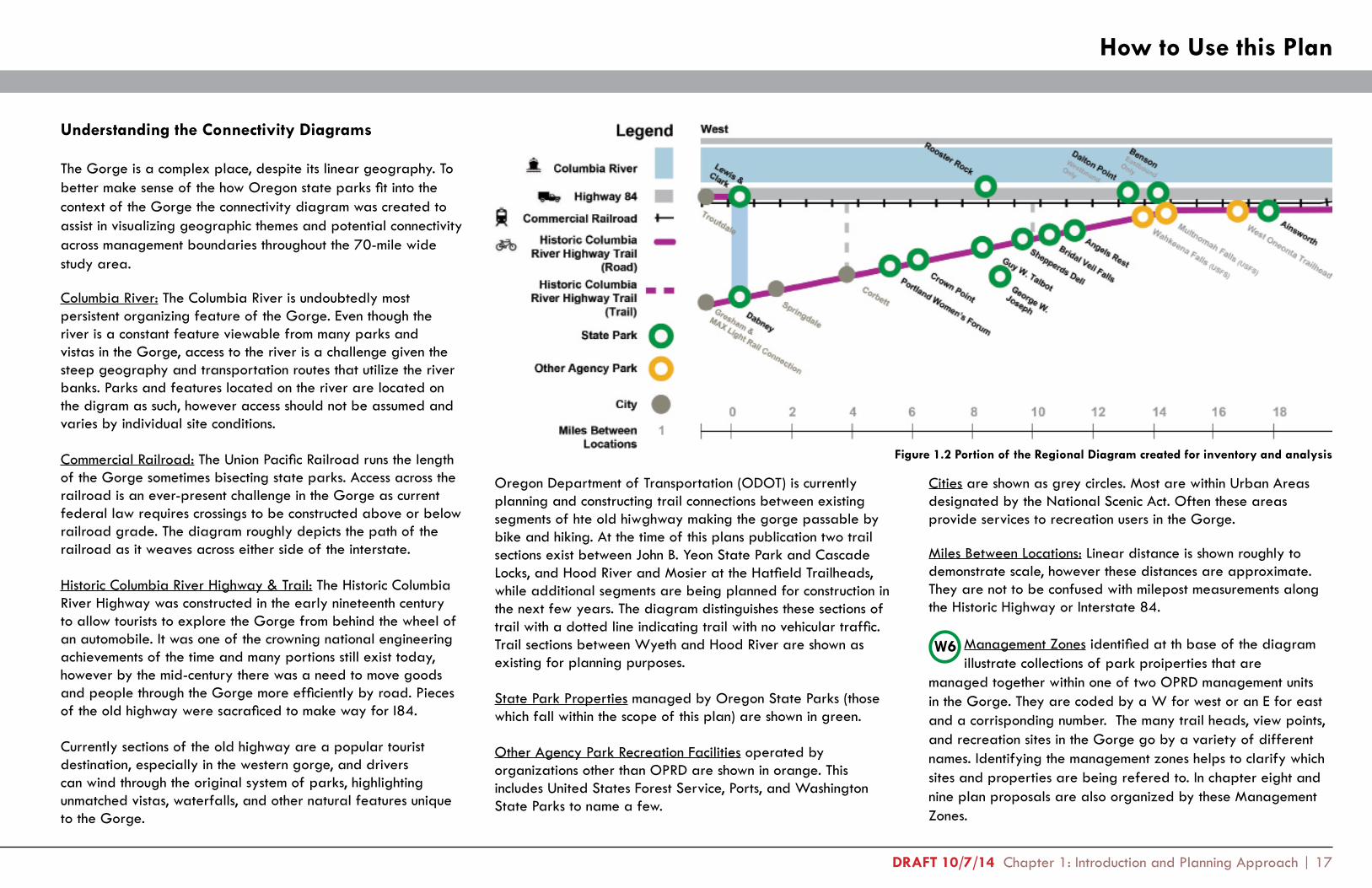
Figure 1.2 Portion of the Regional Diagram created for inventory and analysis
Understanding the Connectivity Diagrams
The Gorge is a complex place, despite its linear geography. To better make sense of the how Oregon state parks fit into the context of the Gorge the connectivity diagram was created to assist in visualizing geographic themes and potential connectivity across management boundaries throughout the 70-mile wide study area.
Columbia River: The Columbia River is undoubtedly most persistent organizing feature of the Gorge. Even though the river is a constant feature viewable from many parks and vistas in the Gorge, access to the river is a challenge given the steep geography and transportation routes that utilize the river banks. Parks and features located on the river are located on the digram as such, however access should not be assumed and varies by individual site conditions.
Commercial Railroad: The Union Pacific Railroad runs the length of the Gorge sometimes bisecting state parks. Access across the railroad is an ever-present challenge in the Gorge as current federal law requires crossings to be constructed above or below railroad grade. The diagram roughly depicts the path of the railroad as it weaves across either side of the interstate.
Historic Columbia River Highway & Trail: The Historic Columbia River Highway was constructed in the early nineteenth century to allow tourists to explore the Gorge from behind the wheel of an automobile. It was one of the crowning national engineering achievements of the time and many portions still exist today, however by the mid-century there was a need to move goods and people through the Gorge more efficiently by road. Pieces of the old highway were sacraficed to make way for I84.
Currently sections of the old highway are a popular tourist destination, especially in the western gorge, and drivers can wind through the original system of parks, highlighting unmatched vistas, waterfalls, and other natural features unique to the Gorge.
Cities are shown as grey circles. Most are within Urban Areas designated by the National Scenic Act. Often these areas provide services to recreation users in the Gorge.
Miles Between Locations: Linear distance is shown roughly to demonstrate scale, however these distances are approximate. They are not to be confused with milepost measurements along the Historic Highway or Interstate 84.
Management Zones identified at th base of the diagram illustrate collections of park proiperties that are
managed together within one of two OPRD management units in the Gorge. They are coded by a W for west or an E for east and a corrisponding number. The many trail heads, view points, and recreation sites in the Gorge go by a variety of different names. Identifying the management zones helps to clarify which sites and properties are being refered to. In chapter eight and nine plan proposals are also organized by these Management Zones.
How to Use this Plan
W6
Oregon Department of Transportation (ODOT) is currently planning and constructing trail connections between existing segments of hte old hiwghway making the gorge passable by bike and hiking. At the time of this plans publication two trail sections exist between John B. Yeon State Park and Cascade Locks, and Hood River and Mosier at the Hatfield Trailheads, while additional segments are being planned for construction in the next few years. The diagram distinguishes these sections of trail with a dotted line indicating trail with no vehicular traffic. Trail sections between Wyeth and Hood River are shown as existing for planning purposes.
State Park Properties managed by Oregon State Parks (those which fall within the scope of this plan) are shown in green.
Other Agency Park Recreation Facilities operated by organizations other than OPRD are shown in orange. This includes United States Forest Service, Ports, and Washington State Parks to name a few.

18 | Columbia River Gorge Management Units Plan: Section One - Existing Conditions DRAFT 10/07/14

DRAFT 10/7/14 Chapter 2: Regional Context | 19
Regional Context
2Situated along the border between Oregon and Washington, the Columbia River Gorge is one of the most unique and inspiring landscapes in the United States. Characterized by steep, forested cliffs, and inscribed with dozens of waterfalls running over high canyon walls into the magnificent Columbia River, the Gorge’s sheer beauty, coupled with its many layers of historic significance, moved Congress to declare it a federally protected National Scenic Area in 1986. The Gorge is now an international tourist destination, known for its scenery and varied recreational opportunities within close proximity to Portland, Oregon’s largest metropolitan area.

20 | Columbia River Gorge Management Units Plan: Section 1 - Existing Conditions DRAFT 10/7/14 Map 2.1 Regional Context of the Columbia River Gorge

DRAFT 10/7/14 Chapter 2: Regional Context | 21
A Brief History of the Gorge
The Columbia River Gorge was created near the end of the last ice age by a series of catastrophic floods which carved out a dramatic canyon laying the course for the Columbia River. Prior to the floods, the area was covered by periodic lava flows, which were uplifted and folded by tectonic activity, then gradually eroded by the river. Around four million years ago the high Cascade Mountains were uplifted and the great volcanoes, including Mt. Hood and Mt. Adams, were formed.
There is evidence that native peoples inhabited the Gorge more than 10,000 years ago. The region’s natural bounty (including large salmon runs up the river) allowed the first people to prosper and develop an elaborate and complex culture. The Gorge was a key transportation corridor, connecting the east and west sides of the Cascades, and developed into a great trading center where tribes met from across the continent.
The Gorge continued to be used as an important trade and transportation corridor beginning with the first European explorers and traders, followed by Lewis and Clark’s expedition and later by the flow of immigrating settlers on the Oregon Trail. Eventually, major river locks, railroads and roads were constructed through the Gorge. Communities sprang up along the commercial routes to serve the major industries; timber, fishing, agriculture and hydropower. The Columbia River Highway, built at the turn of the century, was one of the first roads in the country built specifically to promote touring, scenery and outdoor recreation. Throughout the twentieth century, the Bonneville Power Administration (under the authority of the Federal Government) built several dams on the Columbia, including the Bonneville Dam in 1937, ensuring the public an abundant supply of hydroelectric power. In 1960, construction of The Dalles Dam flooded Celilo Falls, a 15,000-year-old native fishing area and cultural center upriver.
In 1986, the Columbia River Gorge National Scenic Area (CRGNSA) was established to “protect and provide enhancement for scenic, cultural, recreational, and natural resources” in the Gorge and “protect and support the economy
of the Columbia River Gorge area.” This was only the second National Scenic Act to be enacted, and to this day remains the largest at 292,500 acres and is unique for its inclusion of public and private lands, as well as lands across two states. The scenic area stretches for 85 miles along the Columbia River, from the Sandy River to the Deschutes River, and encompasses land in both Washington and Oregon.
The Region Today
Natural Resources
The Columbia River is the largest river in the Pacific Northwest, beginning in the Rocky Mountains of British Columbia and winding through Washington and Oregon to the Pacific Ocean. The Columbia River Gorge marks the river’s passage through the Cascade mountain range, providing a near sea level connection between the coastal marine and inland continental climates of Washington and Oregon. Strong winds are created by this climatic shift and are a dominant feature of the Gorge. During the summer months, winds generally blow from the West, while warm fall winds and cold winter winds often blow from the East.
Plant and animal species diversity in the Gorge is high as a result of the varied topography, habitat gradient (from riverine to mountain) and east-west change in climate. A wide range of habitat types is present, including riparian forests and wetlands, douglas fir forests, rocky outcrops, grasslands, and oak and pine forests. A quarter of all plant species known to occur in the state of Oregon can be found in the Gorge, including over 800 species of wildflowers, which create spectacular displays in spring on the eastern plateaus.
Wildlife is abundant and includes bald eagles, cougars, black bear, deer, yellow-bellied marmots, pacific tree frogs, larch mountain salamanders, and salmon, among many other species. Several runs of chinook and sockeye salmon in the Gorge are federally endangered, while threatened species include runs of chinook, chum, and coho salmon, steelhead, green sturgeon, and the northern spotted owl. The Columbia River Gorge is known for its historic salmon runs, which supported native peoples as well as early Euro-American fishing and canning industries. Salmon, although greatly reduced by over-fishing and the construction of dams, are still an iconic part of the region’s natural and cultural heritage.
Native Americans Drying Salmon in the Gorge, c 1900

22 | Columbia River Gorge Management Units Plan: Section 1 - Existing Conditions DRAFT 10/7/14
Economic Context
Today the Gorge is a major transportation corridor connecting Portland and Vancouver to communities within the Scenic Area and the greater interior Northwest. Goods are moved via river barges, national and state highways, and railways on both sides of the river. Transportation and natural resources (agriculture, forestry, hydro and wind power) represent the area’s largest industries, but recreation and hospitality are also significant economic drivers. Overall, the region’s economy is resilient and growing. Hood River and Wasco counties performed better than the state of Oregon as a whole during the recent recession and continue to outperform many areas of the state in terms of employment and job growth. The Gorge region also benefits from its proximity to the Portland Metropolitan Area, the largest population and employment center in Oregon.
Figure 2.1 Employment by Industry for Oregon Region 9 (Hood River, Wasco, Gilliam, Sherman, and Wheeler counties), 2013. Hood River and Wasco counties contain over 90% of the popula-tion and employment in Region 9 and the majority of urban areas within the Oregon portion of the Columbia Gorge National Scenic Area.
Recreation Context
For local residents, living in the Gorge is like having a year-round membership to the neighborhood gym. Hundreds of miles of roads, trails, bike-paths, and navigable river provide access to hunting, fishing, hiking, watersports, and a host of other recreation activities. These attractions help draw approximately two million local and international visitors to the Gorge each year, bringing economic benefits to the region as well as management challenges. Although recreational opportunities abound on both the Washington and Oregon sides of the river, many of the most heavily visited sites in the Gorge are in Oregon along the first leg of the Historic Columbia River Highway. Demand for access to popular sites like Multnomah Falls, Vista House, and Dabney State Park has outstripped capacity during peak season and is only expected to grow over the next several decades, crowding parks and negatively impacting natural resources and visitor experience. Over-visitation is not limited to the western Gorge; some eastern sites, such as Catherine Creek, a US Forest Service property in Klickitat County, have recently undergone management changes to limit visitor impacts.
Demand for access to the river also presents a challenge for recreation providers to circumvent access barriers such as the railroads and highways.
Recreation in the Gorge is made more complicated by the presence of multiple land managers. Visitors generally do not know (or care) who manages the land unless an issue arises, and often the wrong agency is contacted to address the issue. Agencies responsible for managing recreation on publicly-accessible land in the Gorge include Oregon State Parks (OPRD), Washington State Parks, the US Forest Service (USFS), the US Fish and Wildlife Service, the Bureau of Land Management, local governments, The Nature Conservancy, and other land trusts. On the Oregon side of the Gorge, the primary land managers in terms of acres managed are the USFS and OPRD (see Map 2.2).
In Oregon, OPRD and USFS recreation sites are interspersed along a linear travel corridor and the two agencies share responsibility for coordinating and managing a seamless visitor experience. OPRD parks also overlap with scenic viewpoints and rest areas managed by the Oregon Department of Transportation (ODOT). Rest stops connected to state parks, like Memaloose, are managed by OPRD. Chapter 5 describes other agencies that OPRD works with to provide and maintain recreation facilities in the Gorge.
Historic Columbia River Highway State Trail
ODOT is currently restoring sections of the Historic Columbia River Highway for use as a bicycle and pedestrian path. When complete, these additional sections of the Historic Columbia River Highway State Trail will be managed by OPRD and will significantly enhance access to recreational opportunities along the Oregon side of the Gorge. The completed trail will increase connections between OPRD and Forest Service properties as well as communities like Cascade Locks and Hood River.
7,600
40,300
US Forest Service
Acr
es
8,200
63,000
US Forest Service Oregon Parks and Recreation
Acr
es
7,800
Washington Parks and Recreation
Oregon Parks and Recreation
Total NSAOregon Half of NSA
Source: OPRD Planning Dept., GIS Analysis
Source: OPRD AnalysisSource: Oregon Employment Department
Figure 2.2. Acres managed by the two primary recreation agencies within the Oregon Side of the National Scenic Area
Manufacturing
Information
Construction
Education &Health Services
Leisure &Hospitality
Financial Activities
Trade, Transportation,& Utilities
Professional &Business Services
Natural Resources &Mining
GovernmentOther Services

DRAFT 10/7/14 Chapter 2: Regional Context | 23
OPRD’s Role as a Recreation Provider in the Columbia River Gorge
OPRD was established in 1921 as a branch of the Highway Department. In 1989, the Oregon Legislature separated the agency from the Department of Transportation, forming OPRD as it exists today. State law now requires OPRD to plan for state parks and to update plans on a ten year cycle.
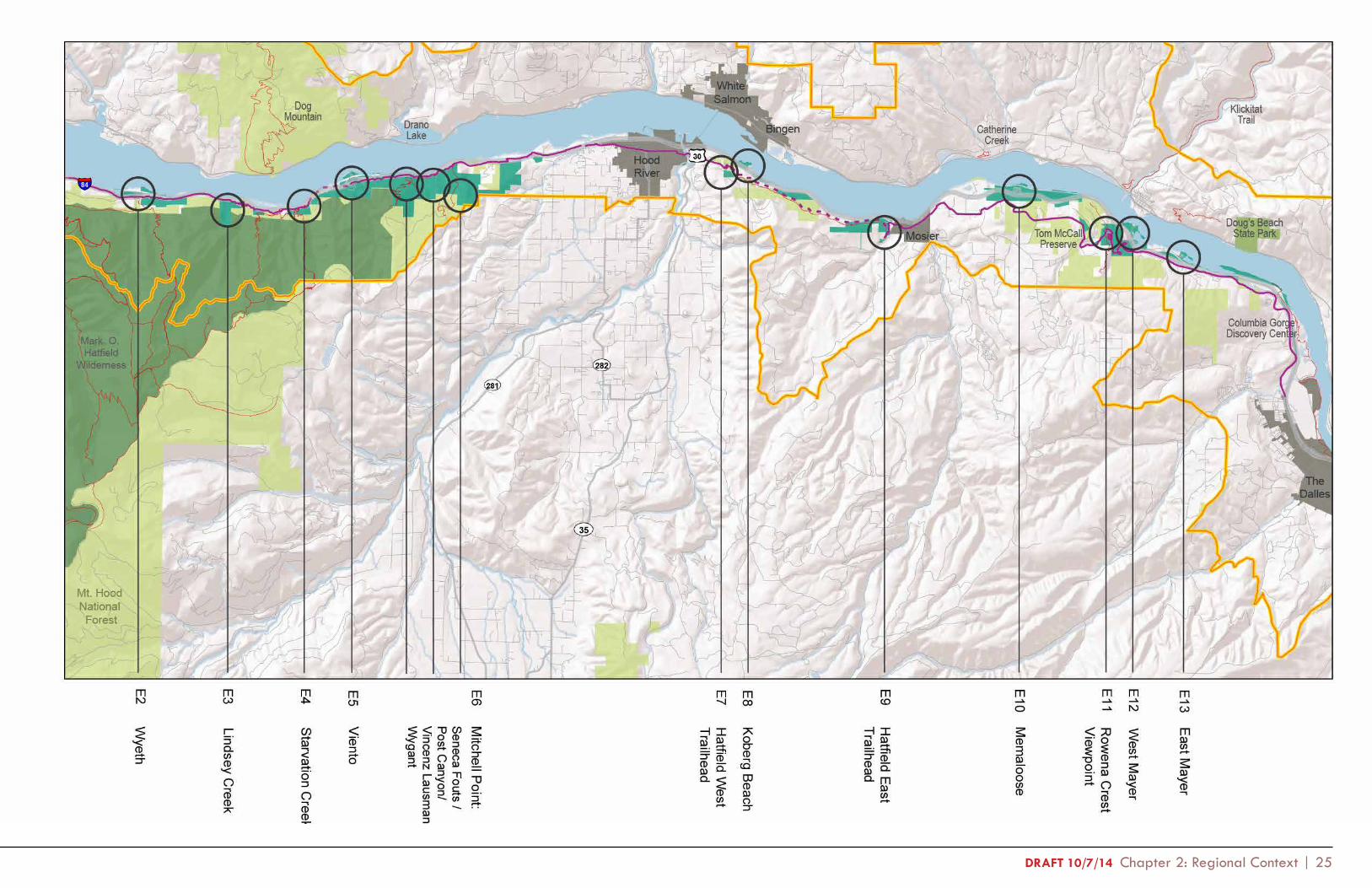
The previous Columbia River Gorge Management Unit Master Plan was approved in 1994. The goal of this plan is to update the 1994 plan to address current trends in recreation and natural resources, emphasizing management strategies for park facilities, natural, cultural, and scenic resources, and the overall quality of visitor experience. The geographic scope includes all current OPRD properties in the Columbia Gorge Management Unit and opportunity areas for future development.
The Gorge area, now divided into two Management Units (East and West), includes 34 individually named OPRD properties totaling approximately 9,500 acres, of which 7,500 acres are located within the CRGNSA. Government Island, Rocky Butte, and Dabney are outside the boundary of the CRGNSA. OPRD properties addressed in this plan are located in Multnomah, Hood River and Wasco counties (see Map 2.2). The East and West Unit headquarters are located at Viento and Rooster Rock State Park, respectively, the Valleys Region headquarters is in Portland, and the state headquarters is in Salem.
The 34 park properties in the Columbia Gorge Management Unit include a variety of designations, including:
• State Parks (SP) - • State Natural Areas (SNA)• State Recreation Sites (SRS)• State Scenic Corridors (SSC)• State Scenic Vistas (SSV)• State Trails (ST)• State Trailheads (STH)
Table 2.1. OPRD Properties in the Columbia Gorge Management Unit (listed geographically, from west to east)
Park AcresGovernment Island SRA 1,937.7Rocky Butte SSC 13.3W1 Lewis and Clark SRS 224.9W2 Dabney SRA 146.8W3 Portland Women’s Forum SSV 243.5W4 Crown Point SSC 82.4W5 Guy W. Talbot SP 392.2W6 George W. Joseph SNA 151.8W7 Rooster Rock SP 1,088.5W8 Shepperd’s Dell SNA 164.2W9 Bridal Veil Falls SSV 17.7W10 Angel’s Rest Trailhead 374.0W11 Dalton Point SRS 39.0W12 Benson SRA 313.9W13 Ainsworth SP 178.8W14 McLoughlin SNA (Undeveloped) 219.5W15 John B. Yeon SSC 254.5W16 Bonneville SSC 46.3W16 Toothrock Trailhead 2.0W17 Sheridan SSC (Undeveloped) 12.4W18 HCRHST: Bridge of the Gods Trailhead 1.0E1 Lang Forest SSC (Undeveloped) 73.5E2 Wyeth SRA (Undeveloped) 265.9E3 Lindsey Creek SSC (Undeveloped) 134.1E4 Starvation Creek SP 124.7E5 Viento SP 293.4E6 Mitchell Point: Wygant SNA 746.1 Vinzenz Lausman (Memorial) SNA 126.7 Seneca Fouts (Memorial) SNA 428.9E7 Hatfield West Trailhead (Approx 1 acre) 19.6E8 Koberg Beach SRS 141.9E9 Historic Columbia River Highway Trail/ Hatfield East Trailhead
211.9
E10 Memaloose SP (and Eastbound Rest Stop) 414.7E11-13 Mayer SP (incl. East & West, Rowena) 689.3TOTAL ACRES 9,575.1The Oregon State Highway Commission at Vista House in August 1943
Park Acres

24 | Columbia River Gorge Management Units Plan: Section 1 - Existing Conditions DRAFT 10/7/14 Map 2.2 Columbia River Gorge Management Unit
DRAFT 10/7/14 Chapter 2: Regional Context | 25

26 | Columbia River Gorge Management Units Plan: Section 1 - Existing Conditions DRAFT 10/7/14
History of State Parks in the Columbia River Gorge
Many of the state park properties in the Gorge were previously owned by important figures in Oregon history. These individuals influenced the development of the Columbia River Gorge as a recreation destination by donating scenic properties for public use and by advocating for better roads as part of the Good Roads movement. The Good Roads movement, initiated by bicyclists and bolstered by the rise in automobile ownership, was a key factor in spurring the construction of the Columbia River Highway through the Gorge in 1915. The highway was America’s first planned scenic road and was supervised by landscape architect and engineer Samuel Lancaster, who had been hired by Good Roads advocate Samuel Hill.
Current state parks in the Gorge supported the Historic Columbia River Highway as recreation destinations. Scenic places like Crown Point and LaTourell Falls drew visitors to the highway and many were added to the state park system throughout the 1920s. OPRD has continued to acquire properties along the highway route and elsewhere in the Gorge up to as recently as 2006.
Since the development of the first Oregon state parks in the Gorge, the over-arching philosophy has been to balance natural and cultural elements, and provide access to the natural wonders of the Gorge through integrated and complementary recreation facilities. This philosophy can be seen in the historic sites associated with the Columbia River Highway and continues as a driving force behind planning in the Gorge today.
The Role of Oregon State Parks in the Columbia River Gorge National Scenic Area
Before considering potential recommendations, it is helpful to answer the question: “What does OPRD do best in the Gorge?” This analysis begins with the agency’s mission:
To provide and protect outstanding natural, scenic, cultural, historic and recreational sites for the enjoyment and education of present and future generations.
As staff work to meet this mission, this plan will help identify how OPRD can best serve the Gorge. OPRD staff have concluded that the agency currently contributes to the Gorge in three significant ways:
Recreation
• Hiking, swimming, wind sports, day-use, fishing, picnicking, wildlife viewing, biking, boating, sightseeing
• Universally Accessible Properties• Affordable Recreation
Managing Significant Public Lands
• Scenic Viewpoints• Historical Sites• River Access Points• Gateway to USFS Properties through Trailhead
Management• Overnight Camping Sites• Natural Areas, Rare Species and Habitats• Parking
Interpretation and Programs
• Beginner Recreation Education (i.e. Let’s Go Program)• Interpretive Programs and Elements• Park Rangers, Interpretive Staff, and Volunteers: Human
Connections in the Gorge
David Talbot (OPRD Director, 1964-1992) wrote about OPRD’s commitment to recreation in the Gorge, shortly after passage of the National Scenic Area Act: “State Parks will continue to be a major supplier of recreation facilities. We are not concerned about who is boss. If we think something needs to be done, we will work it out somehow .”
Now that the regional context of the Gorge has been consid-ered, the plan will identify the existing conditions of state park properties in the Columbia Gorge Management Unit.
Hikers in the Gorge
Gorge Park Managers at Crown Point

DRAFT 10/7/14 Chapter 3: Cultural and Natural Resources | 27
Existing Conditions: Cultural & Natural Resources3
OPRD prepares resource inventories and assessments as a basis for resource management and recreation planning. This chapter summarizes the cultural and natural resource assessments for the Columbia Gorge Management Unit. Landscape character assessments are found in the following chapter, Chapter 4: Visitor Experience Assessments. These reports were prepared by OPRD staff during 2011-2013 in preparation for this plan and can be found in full in the appendix along with additional supporting documents.

28 | Columbia River Gorge Management Units Plan: Section One - Existing Conditions DRAFT 10/7/14
Cultural Resources
The Columbia River Gorge is a geographical region rich with human history and culture. Since the first native peoples arrived more than 10,000 years ago, successive generations have left stories and signs of their presence. The following section outlines key cultural components of the Gorge and OPRD state park properties in order to inform management decisions in these areas.
Cultural Overview of the Gorge Lewis and Clark Expedition
Lewis and Clark’s passage through the Gorge in 1805 and 1806 is well-documented in their journals. By this time the Columbia had been used by Western fur traders for decades. The explorers were duly impressed by the area’s beauty and grandeur, as well as by the vibrant Native American culture along the River’s banks. Journal accounts indicate that Lewis and
Starvation Creek, get their name from railroad-related events. Many parks are still significantly impacted by railroad noise and limited access across tracks even though passenger service no longer exists. Most of the physical evidence of 19th century settlement and industry has disappeared from state parks. The Bridal Veil Timber Company mill that once operated near Bridal Veil Falls is gone, as is the cannery built beneath Rooster Rock in the 1880s.
Native Americans (pre-1800s)
The Columbia River Gorge is the home of tribes belonging to the Chinook people of the Northwest Coast and the Sahaptin people of the interior Columbia Plateau. Native Americans used the Columbia River Gorge as a major trading and travel corridor, drawing in people from all over the North American continent. On the Oregon side, trading centers and settlements were concentrated at the east end of the Gorge, near the present day site of The Dalles. Salmon were harvested in huge numbers from nearby Celilo Falls and other points in the Gorge, providing an important source of food and trade.
Although little physical evidence remains, pre-1800s Native American culture can still be felt in State Parks in the Gorge through names and stories. The name Memaloose, for example, is derived from the Chinookan words for ‘island of the dead’, a reference to the nearby islands in the Columbia River where native peoples buried their dead. At Guy W. Talbot State Park, a Native American legend describes Latourell Falls as the wife of the coyote god Speelya. The legend holds that Speelya transformed his wife into the waterfall to prevent her from escaping him, thus preserving her beauty forever. Stories like these are a reminder that human relationships with the Gorge’s special places go back thousands of years.
Lewis & Clark at Celilo Falls Oregon Capitol Mural by Frank Schwarz
Historic Columbia River Highway ConstructionClark stopped at several current state park properties at the west end of the Gorge, including Shepperd’s Dell and Rooster Rock, where they camped for a night.
Homesteaders, Railroads, Timber, and Fishing (19th century)
The arrival of Euro-American settlers ushered in many changes to the physical and cultural make-up of the Gorge. Homesteaders built farms, orchards, and eventually towns, while loggers cut down forests to produce lumber and fishermen set up large-scale salmon fishing and canning operations. Steamboats initially provided passage and transportation of goods along the river. Later, the construction of railroads along both banks of the River helped to spur the new economy and established a new type of transportation corridor. Many cultures came together in the Gorge during this tumultuous time, including Native American, European, and Chinese cultures, among others.
State parks in the Gorge retain the legacy of these cultures and activities in the form of park namesakes, historic accounts, and proximity to the railroad. Many park properties were donated by homesteaders like George Shepperd or early successful businessmen such as Guy Talbot and Simon Benson. Some parks, like Viento, were built around railroad stations; others, like
The Historic Columbia River Highway (Early 1900’s)
The historic remnants of the Columbia River Highway, constructed between 1913 and 1922, represent perhaps the most significant cultural resource for state parks in the Gorge. The highway, which was designated as a National Historic Landmark in 2000, originally connected all of the most scenic landmarks along the Oregon side of the Gorge, including many that are now part of the state park system. Construction of I-84 in the 1950s, cut off or destroyed many portions of the historic highway. However, the remaining drivable sections still connect visitors to some of the most popular sites in the Gorge, such as Crown Point and Guy Talbot in the west, and Mark O. Hatfield Trailhead and Rowena Overlook in the east. In addition, long unused portions of the highway are being resurrected to serve as hiking/biking sections of the Historic Columbia River Highway State Trail (HCRHST). Many of the cultural resources along the route will be managed by OPRD as part of the HCRHST. These resources include original asphalt, stonework, bridges, and tunnels. OPRD is also responsible for maintaining many of the historic landmarks associated with the Historic Columbia River Highway, such as Vista House at Crown Point, which was built at the same time as the highway to showcase its scenic offerings.

DRAFT 10/7/14 Chapter 3: Cultural and Natural Resources | 29
Civilian Conservation Corps (1930s)
President Franklin D. Roosevelt formed the Civilian Conservation Corps (CCC) during the Great Depression to combat unemployment and enhance the Nation’s infrastructure. A CCC camp was located at Benson State Park and a number of enhancement projects were conducted in Benson and other state parks in the Gorge. CCC crews built and refurbished roads and trails, completed extensive fire hazard reduction, and constructed day use features such as table and bench combinations. Although little evidence of the camp at Benson remains, the paths, benches, bridges, and many other improvements made by the CCC are still present in many parks. One of the more interesting CCC-constructed features is the historic fountain at Ainsworth State Park, where workers enhanced a natural cold water spring with elaborate stonework, steps, and a fountain. The fountain is now a contributing feature of the Columbia River Highway National Historic Landmark District.
Bonneville Dam and Construction of I-84 (Post 1930s)
Bonneville Dam’s construction in the late 1930s altered the flow of the Columbia River and inundated riverside settlements and structures upstream of the dam. These changes have impacted cultural resources in state parks in a number of ways. For example, a popular resort at Koberg Beach was forced to close after the rising river inundated the dance hall, bathhouse, and most of the beach.
I-84 replaced the Columbia River Highway as the primary means of travel through the Gorge in the 1950s and 1960s, cutting off or destroying sections of the old highway. I-84’s alignment along the flatter ground near the railroad has impacted many state parks in terms of noise, access, and cultural resources. A settlement at Viento, for example, was removed to make way for the highway, and Rooster Rock’s facilities were developed in conjunction with work on I-84 to allow large numbers of people to access the park.
The National Scenic Act (1987)
In 1987, Congress passed the Columbia River Gorge National Scenic Act (CRGNSA) in order to preserve and enhance the Gorge’s natural, scenic, cultural, and recreational resources. The CRGNSA called for the creation of a regulatory oversight body, the Columbia River Gorge Commission, and a Management Plan (last updated in 1992), which limits development in areas with significant cultural and scenic resources. Among other measures, areas with large concentrations of cultural resources in state parks and throughout the Gorge are designated Open Space and generally may not be developed.
Contemporary Native American Culture
Native Americans continue to exercise their treaty rights and carry on many of the cultural traditions of their forbearers, including fishing and food gathering in traditional areas, use of traditional medicines, and celebration of native religious ceremonies. A treaty fishing access site is located adjacent to Wyeth State Recreation Area.
Oregon State Park Property Histories
West Management Unit
Lewis and Clark
The Park’s namesakes, Meriwether Lewis and William Clark, camped in this area on November 3, 1805. They were preceded by an earlier European visitor, Lt. William Robert Broughton of the Vancouver Expedition in 1792, for which Broughton Bluff is named. Thirteen tent sites were constructed in 1961 at the base of Broughton Bluff in the former location of the Hicklin Ranch buildings. The number was later increased to 22 and the area was used as an RV park until 1978, when the camping sites were removed and filled with dirt. Smelt fishing was formerly a popular draw to the park and dip nets were used to catch the tiny fish from the Sandy River. The last big smelt run was in 1980, and no runs have occurred since 1985.
Smelt Fishing on the Sandy River at Dabney State Park (c.1930)
Dabney
Richard T. Dabney and his wife Martha Amanda Renshaw originally owned the land and maintained a summer house at the park site until 1916. Henry Renshaw Dabney, their son, filed a subdivision plat on the land in May 1916. The subdivision was never built, and by 1968 the land had been transferred to OPRD.
W1
W2

30 | Columbia River Gorge Management Units Plan: Section One - Existing Conditions DRAFT 10/7/14
WA 14
OR 84OR 30(Undeveloped)
McLoughlinAngels Rest
Herman Creek Horse Camp (USFS)Crown Point
Guy W. Talbot
Rooster Rock
Shepperds Dell
Bridal Veil Falls
Multnomah Falls (USFS)
West Oneonta Trailhead (USFS)
Wahkeena Falls (USFS)
Dabney
John B. Yeon
Eagle Creek Campground (USFS)
Cascade Locks Marine Park
Sheridan
Bridge of the Gods Trailhead
Lang Forest (Undeveloped)
Toothrock Trailhead / Bonneville
Ainsworth
BensonEastboundOnly
George W. Joseph
Portland Women’s Forum
Dalton Point
WestboundOnly
Starvation Creek
Eastbound Only
Viento
Koberg Beach
WestboundOnly
Columbia Gorge
Discovery Center
Tom McCall Preserve
(Nature Conservancy)
Hatfield East Trailhead
Hatfield West Trailhead/
Historic Columbia River Highway
West Mayer
East Mayer
Rowena Crest Viewpoint (Mayer)
Wyeth (Undeveloped)
Wyeth Campground (USFS)
Mitchell Point / Post Canyon
Eastbound Only
Lindsey Creek (Undeveloped)
HCRHT under development between Wyeth & Hood River
Memaloose
Memaloose Rest Area
WestboundOnly
Lewis & Clark
Gresham & MAX Light Rail Connection
Cascade Locks
Troutdale
CorbettSpringdale
Mosier
The Dalles
Hood River
Columbia River
West
Highway 84
Commercial Railroad
Historic ColumbiaRiver Highway Trail
(Trail)
Historic ColumbiaRiver Highway Trail
(Road)
State Park
Other Agency Park
City
Miles BetweenLocations
Legend
1
East
Existing Cultural Resources Inventory
Cultural Resources related to...
Historic Columbia River Hwy
Lewis and Clark ExpeditionEuro-American Settlement
19th c. Railroads & Industry
Native American History
Post-1930s DevelopmentCivilian Conservation Corps
Troutdale
Springdale
Lewis &
Clark
Portland Wom
en’s Forum
Guy W
. TalbotG
eorge W. Joseph
Toothrock Trailhead / Bonneville
Bridge of the G
ods Trailhead
Hatfield East Trailhead
Row
ena Crest View
point
Hatfield W
est Trailhead / Historic
Colum
bia River H
wy
Starvation Creek
Mem
aloose
Koberg B
each
Mitchell Point
West M
ayerEast M
ayer
Rooster R
ockShepperds D
ellB
ridal Veil Falls
Sheridan
Lang Forest
Lindsey Creek
Wyeth
Viento
Ainsw
orth
Angels R
est Trailhead
Dalton Point
Benson
Wahkeena Falls
Multnom
ah Falls
Eagle Creek C
ampground
Wyeth C
ampground
The Dalles W
est Trailhead
Colum
bia Gorge
Discovery C
enter
Tom M
cCall Preserve
Herm
an Creek H
orse Cam
p
Cascade Locks M
arine Park
West O
neonta TrailheadH
orsetail Falls Trailhead
Wahclella Falls Trailhead
John B. Yeon
Crow
n Point
Dabney
Corbett
Warrendale
Cascade Locks Trailhead
Cascade Locks
BotG
Trailhead
Hood R
iver
Mosier
The Dalles
(USFS)
(USFS)
(USFS)
(USFS)
(USFS)
(USFS)
(Undeveloped)
(Undeveloped)
(Undeveloped)
(Wygant/ Vincent / Lausm
ann / Seneca Fouts / Post C
anyon)
(Undeveloped)
(Undeveloped)
McLoughlin
W1
W2
W3
W4
W5
W6
W7
W8
W9
W10
W11
W12
W13
W14
W15
W16
W17
W18
E1 E2
E3 E4 E5 E6
E7 E8 E9 E10
E11
E12E13
20 4 6 8 10 12 14 16 18 20 22 24 26 28 30 32approx.miles
34 36 38 40 42 44 46 48 50 52 54 56 58 60 62 64 66 68 70
(Latourell Falls)
Legend
Can be heard about
Can be seen
Figure 3.1 Existing Cultural Resource Inventory
Cultural Resources Inventory

DRAFT 10/7/14 Chapter 3: Cultural and Natural Resources | 31
Portland Women’s Forum
Land for this park was donated to the state in 1962 by the Portland Women’s Forum, a group of women active in preserving the natural beauty of the Columbia Gorge. The Chanticleer Inn operated here from 1912 to the 1930s, offering travelers country dining and spectacular view of the Gorge. Samuel Hill, Sam Lancaster, John B. Yeon, Simon Benson, and others met at the Inn to plan the construction of the Historic Columbia River Highway. Prior to this, the Inn was as far east from Portland on the county’s road network as anyone could drive (some diners even traveled by train to Rooster Rock, at the river’s edge and then by automobile or carriage up a steep road to the Inn, some 700 feet above the river). In the 1930s, a fifty-ton basalt boulder was moved to the site from the Rocky Butte Quarry to memorialize the road-builder Sam Hill. A relief bust of Sam Hill and bronze plaques depicting Columbia River Gorge history were designed by Seattle sculptor Alonzo Lewis.
Crown Point
Lorens Lund homesteaded the high ground above and including Crown Point in the 1880s and later donated the land for public enjoyment. The dedication of the Columbia River Scenic Highway took place here in 1916. The highway borders much of the south side of the park and extensive historic stone retaining walls and guardrails remain. Outside the park boundaries, the 560-foot spiral viaduct was constructed of reinforced concrete and runs for 225 degrees of a circle around Crown Point. Vista House, now a designated National Historic Landmark, was constructed in 1918 to provide a place of refreshment and rest for highway travelers. A restaurant, the Crown Point Chalet opened in 1915 and operated until 1927; it was demolished in the 1950s.
Construction of Vista House (Image: Friends of Vista House)
Historic Photo of Guy W. Talbot State Park
Sculpture (Alonzo Lewis) at Portland Women’s Forum
Guy W. Talbot
Guy Talbot and his wife Geraldine donated the initial land for the park to the State in memory of their only son, Guy W. Talbot, Junior. The Talbots also donated a house and several outbuildings along with the land. Additional purchases were made in the 1950s and 1960s, including the property containing Latourell Falls. A particularly noteworthy section of the Historic Columbia River Highway called the ‘Figure-Eight Loops’ is adjacent to Guy Talbot State Park. This stretch of highway curves back on itself four times within a short distance as it descends 600 feet between Crown Point and Latourell Falls.
The CCC and the State made a number of improvements to the park in the 1930s, including construction of a foot bridge, guard rails, picnic table-bench combinations, and a stone drinking fountain that still stands.
George W. Joseph
The CCC made small improvements to George W. Joseph in 1933 and 1934, including natural resource enhancements and completion of the path and bridges to access upper Latourell Falls.
W3
W4
W5
W6

32 | Columbia River Gorge Management Units Plan: Section One - Existing Conditions DRAFT 10/7/14
Rooster Rock
Lewis and Clark camped at Rooster Rock in 1805 on their expedition westward. Around 1880, the Rooster Rock Cannery was built by the Columbia River Packers Association in connection with the fish seining and canning industry that dotted the banks of the Columbia River in the late 19th century. Historic ‘penny postcards’ show the location and configuration of the buildings. Rooster Rock State Park was proposed and developed in conjunction with the construction of I-84. The park was dedicated on July 25, 1957, after years of delay caused by highway construction challenges. A large concession building was constructed with restrooms, baths, and office space for the police department. Lifeguards were employed to supervise the thousands of people who visited the beach daily in summer.
Shepperd’s Dell
Historic accounts of the Lewis and Clark Expedition indicate that they stopped at Shepperd’s Dell in 1806. George G. Shepperd, a local farmer of modest means, gave the initial ten acres of this park to the city of Portland in 1915 as a memorial to his wife. It was transferred to the state in 1940. From the Shepperd’s Dell Bridge on the Historic Columbia River Highway, a short concrete
Benson
Simon Benson, a lumber magnate and one of the principal promoters of the Historic Columbia River Gorge Highway, donated land for a park to the City of Portland in 1915. The park served as a CCC camp in the 1930s, from which trails and improvements were built in surrounding areas. The camp was gone by 1939, when the City of Portland transferred the property to the State of Oregon. By this time, Benson State Park was a scheduled stop for sightseeing and interstate busses and a large concessionaire’s building sold meals and merchandise. By the 1950s, the park had day use areas with restrooms, parking, stoves, tables, and a swimming beach.
Ainsworth
The land for Ainsworth State Park was donated by John and Alice Ainsworth of Portland. John was associated with the Oregon Good Roads movement, which grew out of bicyclists and motorists desire for improved roads. The movement spurred construction of the Columbia River Highway, which passes through Ainsworth. In 1934, the CCC surveyed the park boundaries, cleared an acre of land for a campground, and built picnic facilities. In 1935, they developed trails, built the existing fountain next to the highway, and constructed two fireplaces and three table and bench combinations, which have since been replaced.
staircase leads to a narrow pedestrian trail and masonry guard wall designed by Sam Lancaster. The trail ends at view of the stream cascading down from the Dell.
Bridal Veil Falls
The land for Bridal Veil was purchased from various owners between 1970 and 1984. The park adjoins the former location of the Bridal Veil Timber Company, a large logging outfit and mill that operated from 1886 until 1991. The Bridal Veil Post Office is all that remains of the nearby townsite; it remains open for the benefit of people who wish to send wedding invitations stamped “Bridal Veil”.
The Historic Fountain at Ainsworth State Park, built by the Civilian Conservation Corps in 1935 (photo c. 1940)
Bonneville Scenic Corridor
This area was named for Captain Benjamin Bonneville, a French-born explorer who traveled the West in the 1830s. Sam Lancaster, the primary engineer for the Columbia River Highway, owned a portion of the current park and built a resort on it in 1915. The resort later burned and he sold the property, but came back in the 1930s to live in a cabin on the edge of the park. Waldo and Mildred Alcorn sold the first parcel of land to the state in 1933. This parcel was subsequently given to the United States Government in 1933 to service Bonneville Dam, but additional nearby properties were acquired by the state. In 1935, Bonneville Park was laid out by Sam Lancaster on part of his former resort grounds for use by construction workers building the dam.
Beachgoers at Rooster Rock, (photo c. 1960)
W7
W8
W9
W12
W13W16
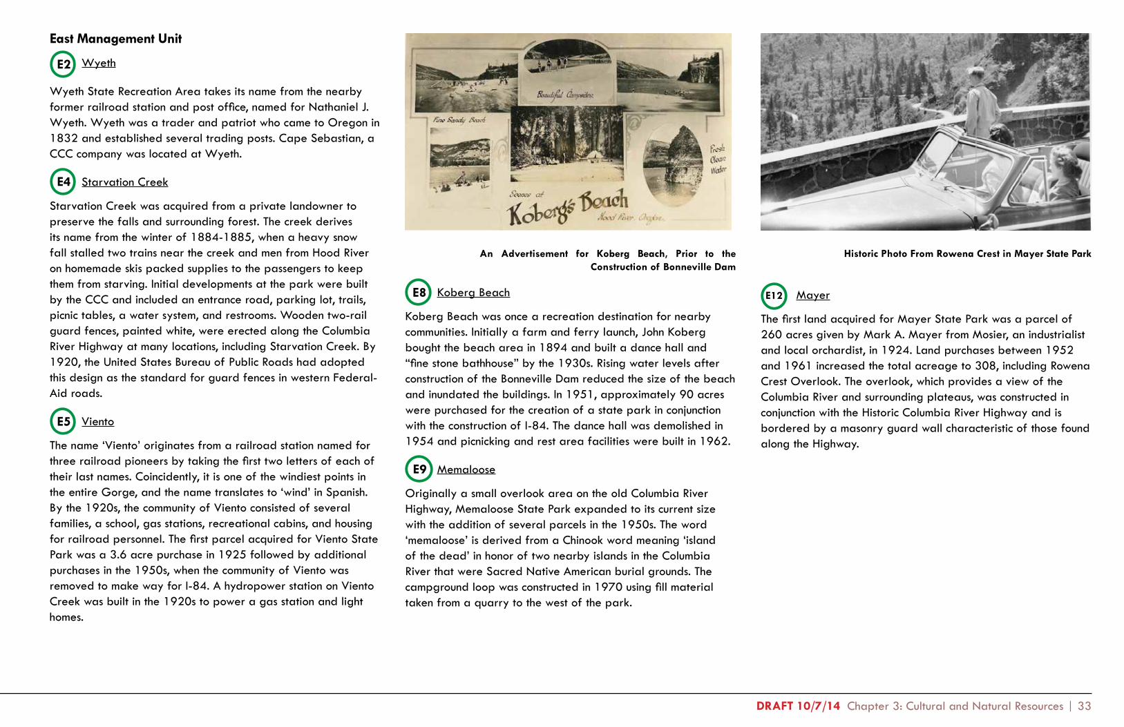
DRAFT 10/7/14 Chapter 3: Cultural and Natural Resources | 33
East Management Unit
Wyeth
Wyeth State Recreation Area takes its name from the nearby former railroad station and post office, named for Nathaniel J. Wyeth. Wyeth was a trader and patriot who came to Oregon in 1832 and established several trading posts. Cape Sebastian, a CCC company was located at Wyeth.
Starvation Creek
Starvation Creek was acquired from a private landowner to preserve the falls and surrounding forest. The creek derives its name from the winter of 1884-1885, when a heavy snow fall stalled two trains near the creek and men from Hood River on homemade skis packed supplies to the passengers to keep them from starving. Initial developments at the park were built by the CCC and included an entrance road, parking lot, trails, picnic tables, a water system, and restrooms. Wooden two-rail guard fences, painted white, were erected along the Columbia River Highway at many locations, including Starvation Creek. By 1920, the United States Bureau of Public Roads had adopted this design as the standard for guard fences in western Federal-Aid roads.
Viento
The name ‘Viento’ originates from a railroad station named for three railroad pioneers by taking the first two letters of each of their last names. Coincidently, it is one of the windiest points in the entire Gorge, and the name translates to ‘wind’ in Spanish. By the 1920s, the community of Viento consisted of several families, a school, gas stations, recreational cabins, and housing for railroad personnel. The first parcel acquired for Viento State Park was a 3.6 acre purchase in 1925 followed by additional purchases in the 1950s, when the community of Viento was removed to make way for I-84. A hydropower station on Viento Creek was built in the 1920s to power a gas station and light homes.
Koberg Beach
Koberg Beach was once a recreation destination for nearby communities. Initially a farm and ferry launch, John Koberg bought the beach area in 1894 and built a dance hall and “fine stone bathhouse” by the 1930s. Rising water levels after construction of the Bonneville Dam reduced the size of the beach and inundated the buildings. In 1951, approximately 90 acres were purchased for the creation of a state park in conjunction with the construction of I-84. The dance hall was demolished in 1954 and picnicking and rest area facilities were built in 1962.
Memaloose
Originally a small overlook area on the old Columbia River Highway, Memaloose State Park expanded to its current size with the addition of several parcels in the 1950s. The word ‘memaloose’ is derived from a Chinook word meaning ‘island of the dead’ in honor of two nearby islands in the Columbia River that were Sacred Native American burial grounds. The campground loop was constructed in 1970 using fill material taken from a quarry to the west of the park.
Mayer
The first land acquired for Mayer State Park was a parcel of 260 acres given by Mark A. Mayer from Mosier, an industrialist and local orchardist, in 1924. Land purchases between 1952 and 1961 increased the total acreage to 308, including Rowena Crest Overlook. The overlook, which provides a view of the Columbia River and surrounding plateaus, was constructed in conjunction with the Historic Columbia River Highway and is bordered by a masonry guard wall characteristic of those found along the Highway.
An Advertisement for Koberg Beach, Prior to the Construction of Bonneville Dam
Historic Photo From Rowena Crest in Mayer State Park
E2
E4
E5
E8
E9
E12

34 | Columbia River Gorge Management Units Plan: Section One - Existing Conditions DRAFT 10/7/14
PortlandMetro
The Dalles
Oregon State Parks
U.S. Forest Service
Figure 3.1 Columbia River Gorge Study Area
Natural Resource Inventory
Three separate assessment reports were prepared by OPRD staff to provide guidance to the planning process and inform broad management strategies to park staff:
1. Vegetation Inventory, Botanical Resource Assessment, and Natural Landscape Characterization
2. Forest Management Technical Report
3. Wildlife Assessment
The findings from these reports have been summarized in this section and the full reports can be found in Appendix 2. The reports describe the natural resources on the Oregon side of the Columbia River Gorge between Portland and The Dalles. Unlike previous plans, the natural resource assessment for this plan was conducted over a broad study area encompassing all land, public and private, within approximately one mile of the south bank of the Columbia River (Figure 3.1). This approach reflects the regional nature of the plan and the emphasis on evaluating state parks within the larger context of the Gorge.
Natural History Overview of the Gorge
The Gorge study area spans four eco-regions and a wide range of ecosystems, climatic zones, and landforms. The following section summarizes the varied natural resources in the study area, including topography, hydrology, soils, climate, and historic vegetation/landcover.
Geology
Columbia River Basalt Flows
The Columbia River Gorge began forming six to sixteen million years ago in the Miocene (well before the Missoula floods), as lava flowed from deep cracks on the Idaho border and covered the land all the way to the ancient coastline (near what is now McMinnville).
As tectonic plates jostled against one another, concurrent with the Columbia River Basalt Group flows, the lateral pressure caused the earth’s crust to fold. A series of these gentle but immense folds in the Columbia River Basalt lava flows cross the Columbia River at an angle. Several beautifully exposed set of folds (including the Ortley and Bingen-Hood River anticlines and The Dalles syncline) can be seen from OPRD properties in the eastern Gorge.
The V-shaped ancestral valleys of the Columbia River offered the easiest downhill route to the sea for many inland lava flows. Successive lava flows solidified into basalt in the river’s channel, with the river cutting a new channel each time to the north of the old one. Basalt remnants of several of the inter-canyon flows can be seen in several OPRD properties.
In the long periods between Columbia River Basalt flows, the Columbia River deposited river gravel, silt and sand in its former channels. These became The Dalles Formation, found in the basins of The Dalles and Mosier, and the Troutdale formation, found in the Hood River and Portland basins. More
Starvation Creek Falls

DRAFT 10/7/14 Chapter 3: Cultural and Natural Resources | 35
recent folding and faulting have caused some pieces of these sedimentary formations to rise well above their original locations to places that can be seen from some OPRD properties.
The High Cascades, located to the east of the older, eroded Cascades, were uplifted about 4 million years ago. During the same period the great composite volcanos, Mt. Hood and Mt. Adams, began their eruptive phase, which continues to the present era. Hundreds of smaller volcanoes and fissures also began to flow with Boring and Cascade lavas.
The Missoula Floods
At the end of the last Ice Age, 15,000 to 13,000 years ago, a series of cataclysmic floods scoured nearly 16,000 square miles of the Columbia River drainage basin. Flood waters were held behind colossal, 1,000 to 2,500 foot high ice dams on the Clark Fork of the Columbia, on the Idaho-Montana border near Lake Pend Oreille. The floods travelled across eastern Washington, tearing away the landscape as it went. They funneled out toward the Pacific through what would become the Columbia Gorge. It is estimated that there were at least 25 floods, recurring on an average of 55 years over the 2,000 year period. The approximate elevation of the flood waters as they passed The Dalles were 1,000 feet above sea level, 600 feet as it passed Crown Point and 400 feet in the Willamette Valley. The Missoula Floods composed of water, mud, and innumerable ice flows packed with boulders, were incredibly destructive in the erosion they caused, creating cliffs up to 3,000 feet high adjacent to the Columbia River with suspended water falls. The major waterfalls later developed large alcoves in the canyon wall, as water froze and expanded in the microscopic cracks of the brickbat- and columnar-jointed basalt. Since the last ice age, alcoves have been eroded several hundred feet back into the cliff face through this process.
Topography
The area’s unique topography has been shaped by the Columbia River and other erosive forces. On the Oregon side, the River’s floodplain gives way abruptly to steeply rising cliffs.
Elevation within the study area ranges from approximately 10 to 600 feet above sea level, often within the space of a mile or less. Landforms such as stair-stepped cliffs, sheer-walled canyons, rock spires, and waterfalls are common. This topographic variability contributes to a diversity of habitat types, and as a result, a high diversity of native plants and wildlife species.
Hydrology
Water flow patterns are correlated with topographic features and a strong east-west precipitation gradient and rain shadow effect. Surface water features include the Columbia River, a number of smaller tributary rivers, streams, lakes, ponds, and wetlands. Many of the streams form spectacular waterfalls as they cascade over cliff faces, eroded rock features, and through canyons, contributing to the dramatic character of the landscape. Meanwhile, below-ground water availability exerts a strong influence over the types of vegetation colonizing the landscape.
Rooster Rock’s Beach Was Severely Eroded During Flooding in 1996 (Image from Crown Point)
Rooster Rock and Crown Point, circa 1937 (State Archives)

36 | Columbia River Gorge Management Units Plan: Section One - Existing Conditions DRAFT 10/7/14
Flooding impacts a large portion of the Columbia River Gorge study area (although impacts are significantly reduced now that dams control much of the river’s flow). Areas most prone to flooding are at low elevations within the 100-year flood plain and along stream terraces. These areas contain the most alluvial soil and are covered by early to mid-seral riparian vegetation. Normal annual flood activity occurs as a result of high precipitation and snow-melt during spring rains. Annual floods affect soil and vegetation composition by scouring soils and knocking down or dislodging established vegetation. Infrequent catastrophic floods have occurred many times in the study area’s past. The Missoula, or Bretz, Floods are an example of catastrophic flood events in the area, as are lesser floods, lahars, and pyroclastic flows caused by volcanic eruptions. Catastrophic flood events such as the Bretz Floods likely had huge effects on the local topography and soils through the combined actions of scouring and deposition of sediment.
Now, however, much of the area’s flooding activity is controlled by dams, a change that is transforming soil and vegetation patterns along the banks of the Columbia River and has significantly altered habitat for native fish and wildlife.
Climate
Climate in the Gorge is generally mild and the area has a relatively long growing season, from mid-February to late November. Precipitation ranges from 44 inches per year at the western end to 30 per year in the arid eastern end, with the heaviest precipitation occurring between the months of November and May. Because of the area’s low elevation, almost all of this precipitation is in the form of rain. The entire area typically has several months of summer drought. The Gorge sees an average of 40 days per year with temperatures below freezing. East winds in winter can be strong and can cause ice storms. Summer east winds are hot and dry and contribute to wildfire spread and risk.
Soils
Most of the low elevation soils within the study area are alluvial, having been deposited by flooding and river flows over several millennia. The majority of these soils have been deposited incrementally from upstream locations, but some, characterized by high sand and gravel content, were probably deposited by the Missoula Floods. Above the flood plain, a variety of soil types are present. Many upland soils were formed on-site from the weathering of native rock; others contain silt and sand components that may have been deposited by the Bretz floods. These mixed soils are deeper in areas of moderate slope that lie at the base of the Gorge’s cliff walls.
Historic Vegetation
Historic and prehistoric vegetation cover can be inferred from early surveyors’ accounts, as well as several large-scale modeling efforts conducted by different organizations, including the Oregon Biodiversity Information Center (ORBIC) and the U.S. Forest Service. Of these, the ORBIC data provides the best approximation of pre-European-American settlement vegetation patterns along the Oregon side of the Columbia River Gorge.
The broad vegetation types present throughout the Gorge just prior to and soon after European-American settlement are reported by all sources to include forest, savanna, grassland, and wetlands. Forest types are assumed to have included Douglas fir forest, mixed Douglas fir and deciduous forest, ponderosa pine forest, and Oregon white oak forest.
Fire Patterns
Lightning was probably the primary cause of prehistoric fires in the Gorge. Prior to European-American settlement, Native Americans throughout the Willamette Valley and the Columbia River Gorge also periodically burned grasslands in order to maintain edible plant and wild game availability.
Different parts of the Gorge have been subject to different fire regimes as a result of local environmental factors. As a rule, fire frequency has historically been higher in the eastern Gorge than Lightning Over the Columbia River Gorge

DRAFT 10/7/14 Chapter 3: Cultural and Natural Resources | 37
in the west. As a result, oak/pine forests and grasslands have burned more frequently than coniferous forests. Peaks, ridges, and drier slopes (east, south, or west facing) have likely burned more frequently than wetter north facing slopes and low-lying, sheltered areas.
Fire frequency has generally decreased in recent times as a result of human intervention and suppression, although fires may have increased along railway and highway corridors. Current fire return intervals may be as long as 150 to 200 years in some parts of the Gorge.
Vegetation Communities
OPRD conducted a comprehensive assessment of plant communities, wetlands, ecological condition, forest age class, noxious weeds, historic vegetation, and rare plant species within the Oregon Columbia River Gorge study area. A stratified approach to characterizing vegetation and ecology was used because of the large size and difficult terrain of the study area. This stratified approach included detailed, ground-based surveys, as well as remotely-sensed characterization of vegetation using aerial imagery. Over 1,200 sample plots were also created based on staff-identified ‘areas of interest’ on state park properties.
The term landcover describes general vegetation and landscape characteristics. For the purposes of this plan, landcover was modeled at two scales: regional and park-specific. The regional scale mapping presents a summary of landcover types most useful at or around the 1:24,000 scale. Twenty-five broad classes of landcover were selected from a multitude of vegetation communities and landscape features to represent the study area. From these, priority habitats were identified and mapped.
Management goals and park-specific management strategies were drafted based on this and prior assessments, taking into account landscape context and the relative importance of OPRD-owned properties within the overall Oregon Gorge environment.
Existing Vegetation
Vegetation in the study area ranges from temperate rainforest and marsh at the western end of the Gorge to semi-arid steppe, savanna, and grassland at the eastern end, varying locally depending on topographic and hydrologic conditions. The rather abrupt transition between wetter western habitats and the more arid eastern habitats is striking and occurs just west of Hood River, near Viento State Park.
Although non-native invasive plant species are widespread and abundant, much of the landscape retains a natural character and provides valuable plant and wildlife habitat. A number of Oregon Conservation Strategy Habitats (at-risk habitats prioritized by the state for preservation and restoration) occur in the study area (See Figure 3.2):
• Oregon oak forest
• Ponderosa pine forest
• Late seral conifer forest
• Native and semi-native grasslands
• Riparian habitats
Other significant habitats, which may support rare plant and and animal species, include:
• Cliffs, rock outcroppings, and scree slopes
• Waterfalls and associated spray zones
OPRD-owned lands in the study area contain a majority of the significant low-lying habitats associated with riparian areas. In contrast, upland habitats like cliffs and waterfalls are found primarily on U.S. Forest Service lands. Three of the Conservation Strategy Habitats (Oregon Oak, Ponderosa Pine, and Grassland) are associated with the arid eastern side of the Gorge and are most abundant on private lands, while late seral conifer forests are found primary on U.S. Forest Service property in the western Gorge. Riparian habitats are distributed along the Columbia River throughout the Gorge; however, Rooster Rock State Park in particular contains a significant proportion of the important riparian habitat in the Gorge.
Lewis’ Mock-orange, a native plant present in a variety of habitat types throughout the western Gorge

38 | Columbia River Gorge Management Units Plan: Section One - Existing Conditions DRAFT 10/7/14
OPRD
USFS
PrivateOther (0.2%)
9% 5%
86%
Percentage of Late Seral Forest Area by Land Ownership
Oregon Oak Ponderosa Pine
Late Seral Forest Semi-Native Grassland
Total Acres = 2,981 Total Acres = 812
Total Acres = 687 Total Acres = 2,409
OPRD
USFS Private
Other (1%)
18%
24%57%
Percentage of Oak Area by Land Ownership Percentage of Pine Area by Land Ownership
OPRD
USFS
Private
Other (2%)
14%
19%
65%
OPRD
USFS
Private
Other (0.5%)
15% 69%
16%
Percentage of Semi-Native Grassland Area by Land Ownership
Oregon Conservation Strategy and Other Significant Habitats

DRAFT 10/7/14 Chapter 3: Cultural and Natural Resources | 39
Figure 3.2 Oregon Conservation Strategy Habitats in the Columbia River Gorge
Riparian Shrub/Willow
OPRD
USFS
Private
Other (6%)
61%
26%
7%
Percentage of Riparian Shrub/Willow Area by Land Ownership
Total Acres = 316
Emergent Wetland
Total = 220
Percentage of Emergent Wetland by Land Ownership
OPRD
USFS
Private
Other (1%)
34%
16%
49%
Riparian Forest
Total = 3,495
Percentage of Riparian Forest by Land Ownership
OPRD
USFS
Private
Other (6%)
46%
9%
40%

40 | Columbia River Gorge Management Units Plan: Section One - Existing Conditions DRAFT 10/7/14
Rare Plants
Many rare plants (as well as rare lichens and fungi) occur within the Columbia Gorge. Most of these species are associated with uncommon or threatened habitats, such as waterfall spray zones, cliffs and rock outcroppings, mudflats, and native bunchgrass grasslands. Some species have naturally limited distributions (such as those that live in waterfall spray zones) and some have been made rare because of human disturbance to their habitats (such as those relying on native bunchgrass prairies).A number of rare plant species in the Gorge have been listed as ‘species of concern’ by the state or federal government. A few (less than five) have been listed as threatened or endangered. These species are subject to strict protection under federal and state laws, however, all sensitive species within the Gorge National Scenic Area are protected under the Gorge Management Plan.
Invasive Plants
Invasive, non-native plant species are prevalent in many parts of the Gorge, particularly around urban and agricultural areas. Other areas, primarily high elevation conifer forests and cliffs, are relatively or even completely free of non-native plants.
Some of the most established, ‘system-modifying’ invasive plant species present in the Gorge include Armenian blackberry, reed canarygrass, non-native knapweeds, tree of heaven, Japanese knotweed, garlic mustard, false brome, English ivy, old man’s beard, dog rose, non-native thistles and geraniums, and yellow flag iris. These species are competitive colonizers in hospitable environments and can completely displace all other species in the habitats they invade. Additional invasive species present in the Gorge, but not as damaging to native habitats, include non-native pasture grasses, dandelion, hairy cat’s ear, and others.
Invasive species have not been mapped at a regional scale in the Gorge, although weed infestations were recorded opportunistically by OPRD during the vegetation assessment. Weed mapping was done on OPRD properties in the Gorge between 2006 and 2008 (See Natural Resource Reports in Appendix), and selected species have been mapped by members of the Gorge Cooperative Weed Management Area (CWMA) as part of species-specific assessment and control projects.Figure 3.4 Non-Conservation Strategy Significant Habitats in the Columbia River Gorge
!! !!!! ! !! !!
!! !!!! ! !!
!! !!!
!!! !
! !!!!!!
!!!
! !!!!!!! !!!!!!!!
!!!! !!! !
!! !
! !!
!!!
!!!
!!!
!!
!! !!
!!!
! !
!!
!!
!!!!
!
!
!
!
!!!! !!!!! !!!
!!!! !!!!!! !!!
!!!!!!!! !!!!
!! !! !!!!!!
! !!! !!!!! !!!! ! !!!!
!!!!!!
!!!!!!
!!! !
!!!! !!!!
!!!
!!!
!!! ! !!
!
!
!!!
! !!!!!!!!! !! !!!!!!
!!!!!
!!!
! !!!
!
!
!
!
!
!
!
!!!!!! !!! !!
!! ! !!!! ! ! !! !!!! !!!
!
!!
!!
!! !
!!!!!! !
!
!
!! ! !!
!!!
!!!
!
!
! !!
! !! !!
!! !!
!!
!
!!
!
!!
!!!! !!
!!!!!!
!
!!!
!
!
! !
!
!!!!! !! !!!!!
!!!
!!!!!!!! !
!!
!!!
!!!
!
!!
!!!
!
!
!!!
!
!
!!
!!!!!!!!
!!!!!!!!
!! !!!
!!!!!!!!!!
!!!!!!!
!!
!!
Cliffs, Rock and Scree
Waterfalls
Total Acres = 992
Total = 432
Percentage of Waterfalls by Land Ownership
OPRD
USFS
Private
Other (0.5%)
18%
58%
23%
OPRD
USFS
Private
Other (0.3%)
23% 19%
58%
Percentage of Cliffs, Rock and Scree Area by Land Ownership

DRAFT 10/7/14 Chapter 3: Cultural and Natural Resources | 41
WA 14
OR 84OR 30(Undeveloped)
McLoughlinAngels Rest
Herman Creek Horse Camp (USFS)Crown Point
Guy W. Talbot
Rooster Rock
Shepperds Dell
Bridal Veil Falls
Multnomah Falls (USFS)
West Oneonta Trailhead (USFS)
Wahkeena Falls (USFS)
Dabney
John B. Yeon
Eagle Creek Campground (USFS)
Cascade Locks Marine Park
Sheridan
Bridge of the Gods Trailhead
Lang Forest (Undeveloped)
Toothrock Trailhead / Bonneville
Ainsworth
BensonEastboundOnly
George W. Joseph
Portland Women’s Forum
Dalton Point
WestboundOnly
Starvation Creek
Eastbound Only
Viento
Koberg Beach
WestboundOnly
Columbia Gorge
Discovery Center
Tom McCall Preserve
(Nature Conservancy)
Hatfield East Trailhead
Hatfield West Trailhead/
Historic Columbia River Highway
West Mayer
East Mayer
Rowena Crest Viewpoint (Mayer)
Wyeth (Undeveloped)
Wyeth Campground (USFS)
Mitchell Point / Post Canyon
Eastbound Only
Lindsey Creek (Undeveloped)
HCRHT under development between Wyeth & Hood River
Memaloose
Memaloose Rest Area
WestboundOnly
Lewis & Clark
Gresham & MAX Light Rail Connection
Cascade Locks
Troutdale
CorbettSpringdale
Mosier
The Dalles
Hood River
Columbia River
West
Highway 84
Commercial Railroad
Historic ColumbiaRiver Highway Trail
(Trail)
Historic ColumbiaRiver Highway Trail
(Road)
State Park
Other Agency Park
City
Miles BetweenLocations
Legend
1
East
Existing State of Oregon Priority Habitats
Troutdale
Springdale
Lewis &
Clark
Portland Wom
en’s Forum
Guy W
. TalbotG
eorge W. Joseph
Toothrock Trailhead / Bonneville
Bridge of the G
ods Trailhead
Hatfield East Trailhead
Row
ena Crest View
point
Hatfield W
est Trailhead / Historic
Colum
bia River H
wy
Starvation Creek
Mem
aloose
Koberg B
each
Mitchell Point
West M
ayerEast M
ayer
Rooster R
ockShepperds D
ellB
ridal Veil Falls
Sheridan
Lang Forest
Lindsey Creek
Wyeth
Viento
Ainsw
orth
Angels R
est Trailhead
Dalton Point
Benson
Wahkeena Falls
Multnom
ah Falls
Eagle Creek C
ampground
Wyeth C
ampground
The Dalles W
est Trailhead
Colum
bia Gorge
Discovery C
enter
Tom M
cCall Preserve
Herm
an Creek H
orse Cam
p
Cascade Locks M
arine Park
West O
neonta TrailheadH
orsetail Falls Trailhead
Wahclella Falls Trailhead
John B. Yeon
Crow
n Point
Dabney
Corbett
Warrendale
Cascade Locks Trailhead
Cascade Locks
BotG
Trailhead
Hood R
iver
Mosier
The Dalles
(USFS)
(USFS)
(USFS)
(USFS)
(USFS)
(USFS)
(Undeveloped)
(Undeveloped)
(Undeveloped)
(Wygant/ Vincent / Lausm
ann / Seneca Fouts / Post C
anyon)
(Undeveloped)
(Undeveloped)
McLoughlin
W1
W2
W3
W4
W5
W6
W7
W8
W9
W10
W11
W12
W13
W14
W15
W16
W17
W18
E1 E2
E3 E4 E5 E6
E7 E8 E9 E10
E11
E12E13
20 4 6 8 10 12 14 16 18 20 22 24 26 28 30 32approx.miles
34 36 38 40 42 44 46 48 50 52 54 56 58 60 62 64 66 68 70
(Latourell Falls)
Riparian Forest
Ponderosa PineRiparian Shrub/Willow
Semi-Native Grassland
Oregon Oak
Waterfalls
Cliffs, Rock & ScreeSignificant Gorge Habitats
Emergent WetlandLate Seral Forest
Conservation Strategy Habitats
Oregon Conservation Strategy
Figure 3.4 Existing Oregon Priority Habitats
Oregon Conservation Strategy & Other Significant Habitats

42 | Columbia River Gorge Management Units Plan: Section One - Existing Conditions DRAFT 10/7/14
Benson
The state reserve near and within Benson contains some of the best examples of waterfalls and spray zones in the Gorge, providing a unique habitat that supports rare plants and animals. The reserve also contains a small, late seral stand of Douglas fir forest.
Guy Talbot & George W. Joseph
These two parks contain a relatively large, protected reserve with two waterfall areas. The waterfall spray zones support rare plant populations and potentially rare animal populations as well.
Rooster Rock
The state reserve within Rooster Rock contains the highest quality example of wapato wetland remaining in Western Oregon. This wetland type was formerly common along sloughs in the Portland area between Rooster Rock and Sauvie Island. Almost all of the sites have now been destroyed by overgrazing or development. These wetlands are important biologically and culturally; historically, Native Americans in the area relied on
Sand Island Area at Rooster Rock State Park
State Natural Area Reserves
Twelve State Natural Area reserves have been designated within the Oregon portion of the Gorge. More information on how these areas were identified can be found in the state’s Oregon Natural Areas Plan (2010). Eleven of the reserves are within OPRD parks, at Benson, Bridal Veil, Koberg Beach, Shepherd’s Dell, John Yeon, Guy Talbot, George Joseph, Memaloose, Rooster Rock, Mayer, and Starvation Creek. The remaining reserve in the Gorge is owned by The Nature Conservancy adjacent to Rowena Overlook. These areas have been conserved as important examples of native habitats occurring in Oregon, and natural values have been identified for each that should be protected and enhanced where possible.
Individual State Natural Area Reserve Values
The following descriptions of natural values for each State Natural Reserves that occur in state parks have been adapted from text prepared by the Oregon Natural Heritage Advisory Council to the State Land Board.
Licorice Fern growing near a spray zone at Bridal Veil Falls
W3
W5
W7
W6

DRAFT 10/7/14 Chapter 3: Cultural and Natural Resources | 43
The Sand Island portion of the reserve contains the last remaining unstabilized sand dunes on the lower Columbia River. They are a product of Gorge winds and sands presumably derived from the Table Mountain landslide near Cascade Locks. Cyclical stabilization and subsequent wind erosion have created a landscape reminiscent of the coastal Oregon Dunes National Recreation Area, with imposing 100-foot dunes and active burial of riparian cottonwood forest. This feature is of great regional significance, as almost all other riparian sand dune features in the Gorge have been inundated behind dams on the Columbia River or stabilized by vegetation. The site also contains excellent examples of riparian ash-cottonwood forest and river willow-Pacific willow thickets.
Shepperd’s Dell
This reserve contains small but excellent examples of waterfalls and associated spray zones, providing a unique habitat at the western end of the Gorge that likely supports rare plants and animals. There are also small stands of late seral Douglas fir forest.
Bridal Veil Falls
The reserve at Bridal Veil Falls includes waterfalls and associated spray zones, potentially supporting rare plants and animals. It also contains a small, undisturbed stand of late seral Douglas fir forest.
John B. Yeon
The park contains a small but excellent example of waterfall and cliff vegetation representative of this portion of the Columbia River Gorge. It has more than a dozen plant species of concern, making it one of the most diverse rare plant habitats in the Gorge.
Starvation Creek
The reserve site at Starvation Creek includes an excellent example of waterfall and talus vegetation, as well as small stands of late seral douglas fir forest. A number of rare plant and animal species are known to occur here.
Koberg Beach
The Columbia Oaks area has some of the best remaining examples of Oregon oak/ponderosa pine savanna and grand fir-Douglas fir forest in the eastern Gorge. It also has Oregon’s largest population of the very showy, cliff dwelling Barrett’s penstemon.
Memaloose
Memaloose has some of the best remaining riparian vegetation in the eastern Columbia River Gorge, including willow, cottonwood and hawthorn woodlands. The reserve contains diverse uplands with pine, oak, bunchgrass and native shrubs. It also has Oregon’s largest population of Nevius’ onion, a species endemic to the Columbia River Gorge.
Mayer
Rowena Plateau is one of the premier natural areas in the eastern half of the Columbia River Gorge. The grasslands, ponderosa pine-Oregon oak covered talus slopes, and vernal ponds provide a unique and important matrix of natural ecosystems. Rowena has Oregon’s largest population of the Hood River milkvetch, a plant only found in the eastern Columbia River Gorge. The reserve also contains dramatic basalt cliffs from which visitors can enjoy spectacular vistas of the eastern Gorge.
Squally Point Dunes, east of Rowena, represent the only remaining Columbia River Gorge sand dunes on the mainland. This dune ecosystem characterized The Dalles area before the construction of dams on the lower Columbia River.
Mixed Conifer Forest at Ainsworth State Park
W8
W9
W15
E4
E8
E10
E12

44 | Columbia River Gorge Management Units Plan: Section One - Existing Conditions DRAFT 10/7/14
WA 14
OR 84OR 30(Undeveloped)
McLoughlinAngels Rest
Herman Creek Horse Camp (USFS)Crown Point
Guy W. Talbot
Rooster Rock
Shepperds Dell
Bridal Veil Falls
Multnomah Falls (USFS)
West Oneonta Trailhead (USFS)
Wahkeena Falls (USFS)
Dabney
John B. Yeon
Eagle Creek Campground (USFS)
Cascade Locks Marine Park
Sheridan
Bridge of the Gods Trailhead
Lang Forest (Undeveloped)
Toothrock Trailhead / Bonneville
Ainsworth
BensonEastboundOnly
George W. Joseph
Portland Women’s Forum
Dalton Point
WestboundOnly
Starvation Creek
Eastbound Only
Viento
Koberg Beach
WestboundOnly
Columbia Gorge
Discovery Center
Tom McCall Preserve
(Nature Conservancy)
Hatfield East Trailhead
Hatfield West Trailhead/
Historic Columbia River Highway
West Mayer
East Mayer
Rowena Crest Viewpoint (Mayer)
Wyeth (Undeveloped)
Wyeth Campground (USFS)
Mitchell Point / Post Canyon
Eastbound Only
Lindsey Creek (Undeveloped)
HCRHT under development between Wyeth & Hood River
Memaloose
Memaloose Rest Area
WestboundOnly
Lewis & Clark
Gresham & MAX Light Rail Connection
Cascade Locks
Troutdale
CorbettSpringdale
Mosier
The Dalles
Hood River
Columbia River
West
Highway 84
Commercial Railroad
Historic ColumbiaRiver Highway Trail
(Trail)
Historic ColumbiaRiver Highway Trail
(Road)
State Park
Other Agency Park
City
Miles BetweenLocations
Legend
1
East
Existing Habitat Connectivity & Wildlife Resource Values
Troutdale
Springdale
Lewis &
Clark
Portland Wom
en’s Forum
Guy W
. TalbotG
eorge W. Joseph
Toothrock Trailhead / Bonneville
Bridge of the G
ods Trailhead
Hatfield East Trailhead
Row
ena Crest View
point
Hatfield W
est Trailhead / Historic
Colum
bia River H
wy
Starvation Creek
Mem
aloose
Koberg B
each
Mitchell Point
West M
ayerEast M
ayer
Rooster R
ockShepperds D
ellB
ridal Veil Falls
Sheridan
Lang Forest
Lindsey Creek
Wyeth
Viento
Ainsw
orth
Angels R
est Trailhead
Dalton Point
Benson
Wahkeena Falls
Multnom
ah Falls
Eagle Creek C
ampground
Wyeth C
ampground
The Dalles W
est Trailhead
Colum
bia Gorge
Discovery C
enter
Tom M
cCall Preserve
Herm
an Creek H
orse Cam
p
Cascade Locks M
arine Park
West O
neonta TrailheadH
orsetail Falls Trailhead
Wahclella Falls Trailhead
John B. Yeon
Crow
n Point
Dabney
Corbett
Warrendale
Cascade Locks Trailhead
Cascade Locks
BotG
Trailhead
Hood R
iver
Mosier
The Dalles
(USFS)
(USFS)
(USFS)
(USFS)
(USFS)
(USFS)
(Undeveloped)
(Undeveloped)
(Undeveloped)
(Wygant/ Vincent / Lausm
ann / Seneca Fouts / Post C
anyon)
(Undeveloped)
(Undeveloped)
McLoughlin
W1
W2
W3
W4
W5
W6
W7
W8
W9
W10
W11
W12
W13
W14
W15
W16
W17
W18
E1 E2
E3 E4 E5 E6
E7 E8 E9 E10
E11
E12E13
20 4 6 8 10 12 14 16 18 20 22 24 26 28 30 32approx.miles
34 36 38 40 42 44 46 48 50 52 54 56 58 60 62 64 66 68 70
(Latourell Falls)
Birds
STREAMFish
FOREST
Large MammalsSmall Mammals
Herptiles (Amphibians & Reptiles)
Habitat Connectivity
1 - Protected Area
4 - Low Wildlife Value
2 - Medium Wildlife Value3 - Marginal Wildlife Value
Wildlife Resource Values
Figure 3.5 Existing Wildlife Connectivity and Habitiat Value
Habitat Connectivity & Wildlife Resource Values

DRAFT 10/7/14 Chapter 3: Cultural and Natural Resources | 45
Wildlife Assessment Summary
Several different types of wildlife assessments were completed for the Columbia Gorge Management Units (CGMUs), including high-level, broad habitat availability and management challenges; a brief, but focused individual analysis of each of the state parks located within the CGMUs; an assessment of habitat connectivity at regional and park-specific scales; a discussion of at-risk wildlife species; and an analysis of threats to these species. The following sections summarize these portions of the report. The full report can be found in the Appendix.
The Gorge is a large and diverse management area. It is home to a wide array of plants and animals, including a number of endemic species found only in the Gorge. State parks within this area are diverse as well. They range in size from eight to over 2,000 acres, with an average size of 300 acres. Many are highly developed, featuring recreation facilities, while others are entirely undeveloped and contain relatively undisturbed habitat. Most of the parks within the CGMU, however, are a mixture of developed and undeveloped areas.
State parks in the Gorge provide habitat for a variety of species, including songbirds, small mammals, reptiles and amphibians. Unique habitats within parks provide homes for many at-risk species, such as the Larch Mountain salamander and the peregrine falcon. In addition, parks contain numerous streams and wetlands with backwater or side channel areas providing key habitats for fish and wildlife. Many of the state parks border land managed by the USFS, creating opportunities for habitat connectivity and management partnerships.
The majority of state parks in the Gorge are adjacent to I-84, the Union Pacific Railroad, or the Historic Columbia River Highway. Both highways and the railroad impact habitat quality and quantity by severing habitat connectivity and causing disturbance from noise, litter, stormwater runoff, noxious weeds and other factors. Invasive weeds associated with these transportation corridors also impact native fish and wildlife by degrading habitat quality and limiting species movement.
Many of the state parks in the Gorge host some form of recreation. Public use of recreation facilities such as roads, trails, boat ramps, kite launch sites, disc golf courses, picnic areas, viewing platforms, and campsites disturbs wildlife both directly (e.g., noise, human presence) and indirectly (e.g., litter, informal trails, etc.). In many areas, recreation impacts are effectively controlled through fencing, signage and carefully placed facilities, however, public use continues to impact the quality and quantity of habitat available.
Habitat Connectivity
Protecting and promoting habitat connectivity is one of the larger challenges facing the management of state parks in the Gorge, in part because many of OPRD’s properties are separated by large distances. On the other hand, the large tracts of US Forest Service land adjacent to many state park properties benefit connectivity, since USFS lands in the Gorge are are afforded special protection for fish and wildlife habitat. Where USFS lands abut state parks, large swaths of quality, relatively undisturbed habitat are present, allowing for broad-scale species movement and dispersal.
Forestry Management Report Summary
The Forest Management Technical Report (2013) was prepared to accompany and provide guidance for the Comprehensive Plan for OPRD properties in the Columbia River Gorge Management Unit. The report summarizes current conditions and broad management recommendations for forest stands within the planning area. Stand conditions were assessed and management recommendations were made based on the guidelines in the OPRD Forest Management Policy. This policy was created in 2004 and guides forest management decisions on OPRD property statewide.
Ninety-nine individual forest stands, totalling 4,228 acres, were identified on 23 OPRD properties using digital orthophotos and GIS software. Properties on which trees are not the dominant vegetation, or where OPRD or transportation infrastructure would be the major management influence on vegetation, were not included. Accessible stands (75 out of the 99) were visited to ground-truth orthophoto observations, using a combination of ocular estimation and inventory plots
Most of the forested areas in the Columbia Gorge Planning Area are currently in a condition that meets the guidelines in the OPRD Forest Management Policy. Management intervention is recommended on less than 10% of the 4,228 acres surveyed in the planning area. Stands requiring urgent intervention to meet OPRD objectives have been identified, as have stands with rare or unique characteristics (for more details, see the full report in the Appendix).
Forest management in the Gorge requires lengthy and complex permitting processes. As a result, implementation of some forest management recommendations may be cost-prohibitive without dedicating additional funding. Current stand conditions will change over time with disturbances such as storm damage, insect attack and fire, so it is likely that forest management activities will be warranted on a larger percentage of the surveyed area in the future.
Spawning coho salmon

46 | Columbia River Gorge Management Units Plan: Section One - Existing Conditions DRAFT 10/7/14
However, in locations where state park properties abut privately-held lands, habitat connectivity is generally lacking. Private lands bordering the CGMU have largely been developed for agriculture, rural residential, or industrial forestland purposes. In particular, parks located at the far western and eastern edges of the Gorge, which are more populated and more apt to be in private ownership, lack habitat connectivity more than those parks located in the center of the Gorge along USFS land ownership.
I-84 presents a significant barrier to species movement in the Gorge. Terrestrial species of all kinds are killed by vehicles while trying to cross the highway, and aquatic species movement is impacted by stream barriers and stream re-routes imposed by the highway’s construction. The Historic Columbia River Highway and Union Pacific Railroad, although narrower, also limit species movement. The Historic Highway, in particular, may actually be a more significant barrier (especially for smaller species like salamanders) because its elevated location bisects terrestrial migration routes.
Natural barriers to species movement also exist in the Gorge. The Columbia River, , although a key east-west migration corridor for fish and aquatic species in the Columbia Basin, presents a large barrier to terrestrial species movement and ends habitat connectivity to the north for the majority of state parks. In addition, the steep slopes and cliff faces in the Gorge are a barrier to movement for many species, especially large species, such as elk and deer. Waterfalls at these cliff faces limit aquatic species movements upstream. These natural barriers, combined with artificial north-south barriers like the highways, make habitat connectivity along the east-west corridors in the Gorge especially important for wildlife.
Threats to At-Risk Fish and Wildlife Species
The Gorge provides habitat for a variety of at-risk species. Many of the at-risk wildlife require special habitats for survival. As these habitats diminish or are impacted by disturbances and habitat degradation, at-risk species become more imperiled. Threats to at-risk fish and wildlife species within the Gorge can generally be categorized into one of the following:
• Habitat destruction caused by development and land conversion
• Habitat degradation from current and future land uses
• Loss of habitat connectivity due to barriers to species movement, habitat destruction, and a patchwork of land ownership (especially in the eastern Gorge).
Existing Condition Assessment Role in the Planning Process
Collectively, these existing condition assessments provide guidance to the planning process with new facilities proposals, project prioritization, interpretive opportunities, and natural resource protection. These assessments also assist park staff as they manage the parks for historical, scenic, and natural resource quality over the coming years.


