385 Inside Katrina’s perfectly formed eye, viewed from the NOAA P-3 Hurricane Hunter, Sunday, August 28, 2005. The Category 5 system was moving north through the central Gulf of Mexico at the time, sixteen hours prior to landfall in Louisiana. Photograph courtesy NOAA. HURRICANE KATRINA AND THE GEOGRAPHIES OF CATASTROPHE Dusk, Sunday, August 28, 2005, finds Marina and me darting about making last-minute preparations for the impend- ing landfall of Hurricane Katrina. Nailing down the shutters. Cutting plywood into panels, slipping them between the win- dows and security bars, then jamming them in place with frag- ments of old brick. Filling every jar, cup, and basin with water, then freezing as many as possible. Cooking. Laundering. Secur- ing loose objects. Local news stations gush heroically round-the- clock, providing the soundtrack for the increasingly tense mo- ments. There are the standard hurricane clichés: “Batten down the hatches.” “Hunker down.” “Barreling in.” “Pounding.” And then the New Orleans variations: “Floodwalls.” “Contraflow.” “Breach the levees.” “Can’t pump water uphill.” But tonight, we hear a more ominous lexicon, one that, until today, has only been uttered theoretically: “Worst-case scenario.” “Devastating.” “Catastrophic.” Outside, the outermost feeder bands begin to swirl in; the sky has turned a sickly yellow-gray, and low-hanging clouds race menacingly from an unusual northerly direction. Eleven of the fifteen households on our Ninth Ward block have already evacu- ated. My final preparation is to photograph our house—an 1893 Victorian Italianate shotgun, like thousands others in New Or- leans—inside and out, for insurance purposes. As I snap the shut- ter from across the street, a cooing sound catches my attention. It is a flock of pigeons huddled like penguins on the neighbor’s apron roof, an odd sight for a late summer eve. Directly above our house appears an even stranger spectacle, particularly for the downtown of a major American city: A flock of long-legged, long-necked marsh birds—ibis, I think—hovers placidly, as if suspended from strings; knowingly, as if pre-programmed and perfectly prepared for what looms. They seem to symbolize that supremely potent natural forces are about to seize control of nature from feeble, arrogant hands, to deliver a massive and humbling blow. Long suffering the consequences of man’s actions, the suspended marsh birds seem content with this reversal of fortune. I return to the house, worried. The decision to remain home, rather than heed the pleadings of emergency management officials to evacuate, is mine; I bear responsibly for both our lives. On Tuesday, August 23, 2005, tropical air fueled by unusually warm ocean water spiraled in an upward counter- clockwise direction over the southeastern Bahamas, edging westward. The column of low pressure sucked increasing quantities of heated air into the system, growing it sufficient- ly for the National Hurricane Center to classify it as Tropical Depression 12, and by the next morning, as Tropical Storm Katrina. By late Thursday afternoon, Category 1 Hurri- cane Katrina approached the metropolis of southern Florida with seventy-five-miles-per-hour winds. The system and its torrential rains killed nine people in the north Miami area overnight, and survived the jaunt over the Florida peninsula. Although the 2005 hurricane season had been accurately pre- dicted as an extraordinarily busy one, tropical activity had disarmingly abated during July and August, and most New Orleanians only passively took note of the seemingly weak and distant storm. But awaiting Katrina in the gulf was a gigantic source of storm fuel: a loop current of deeply lay- ered warm water, pulsating in from the Caribbean between Cuba and the Yucatan and breaking off into eddies through the Gulf of Mexico before exiting into the Atlantic between Cuba and Florida. With sea surface temperatures around 90 degrees and more warmth below, a system that made it into the gulf at this particular time would strengthen dramatically without the reprieve of cooler sub-surface waters. At first, computer models forecast tracks up the Florida peninsula, then westward over the panhandle, then further westward to the Alabama border, where so many storms had landed dur- ing the recent ten-year surge in tropical activity. The farther west Katrina crept, the more it drew from the warmth of the loop current, and the more seriously it threatened gulf coastal communities. Yet as schools and offices closed down in New Orleans on Friday afternoon, most conversations and e-mail communications concerned weekend plans and next week’s meetings, not evacuations and possible closures, much less a national calamity. It was not until that evening, by which time the forecast tracks started pointing to the Louisiana/ Mississippi border and Gov. Kathleen Blanco declared a state of emergency, that citywide attention turned to the heighten- ing threat. “Katrina Puts End to Lull” read a headline of the Times-Picayune on Saturday morning. With Katrina a strengthening Category 3 storm and the notoriously divergent computer models now all ominously concurring on a Louisiana landfall, the central Gulf Coast population finally mobilized on Saturday. Emergencies were Geographies of New Orleans by Richard Campanella Please order on amazon.com Geographies of New Orleans by Richard Campanella Please order on amazon.com
Transcript
385
Inside Katrina’s perfectly formed eye, viewed from the NOAA P-3 Hurricane Hunter, Sunday, August 28, 2005. The Category 5 system was moving north through the central Gulf of Mexico at the time, sixteen hours prior to landfall in Louisiana. Photograph courtesy NOAA.
HURRICANE KATRINA AND THE GEOGRAPHIES OF CATASTROPHE
Dusk, Sunday, August 28, 2005, finds Marina and me darting about making last-minute preparations for the impend-ing landfall of Hurricane Katrina. Nailing down the shutters. Cutting plywood into panels, slipping them between the win-dows and security bars, then jamming them in place with frag-ments of old brick. Filling every jar, cup, and basin with water, then freezing as many as possible. Cooking. Laundering. Secur-ing loose objects. Local news stations gush heroically round-the-clock, providing the soundtrack for the increasingly tense mo-ments. There are the standard hurricane clichés: “Batten down the hatches.” “Hunker down.” “Barreling in.” “Pounding.” And then the New Orleans variations: “Floodwalls.” “Contraflow.” “Breach the levees.” “Can’t pump water uphill.” But tonight, we hear a more ominous lexicon, one that, until today, has only been uttered theoretically:
“Worst-case scenario.” “Devastating.” “Catastrophic.” Outside, the outermost feeder bands begin to swirl in; the
sky has turned a sickly yellow-gray, and low-hanging clouds race menacingly from an unusual northerly direction. Eleven of the fifteen households on our Ninth Ward block have already evacu-ated. My final preparation is to photograph our house—an 1893 Victorian Italianate shotgun, like thousands others in New Or-leans—inside and out, for insurance purposes. As I snap the shut-ter from across the street, a cooing sound catches my attention. It is a flock of pigeons huddled like penguins on the neighbor’s apron roof, an odd sight for a late summer eve. Directly above our house appears an even stranger spectacle, particularly for the downtown of a major American city: A flock of long-legged, long-necked marsh birds—ibis, I think—hovers placidly, as if suspended from strings; knowingly, as if pre-programmed and perfectly prepared for what looms. They seem to symbolize that supremely potent natural forces are about to seize control of nature from feeble, arrogant hands, to deliver a massive and humbling blow. Long suffering the consequences of man’s actions, the suspended marsh birds seem content with this reversal of fortune. I return to the house, worried. The decision to remain home, rather than heed the pleadings of emergency management officials to evacuate, is mine; I bear responsibly for both our lives.
On Tuesday, August 23, 2005, tropical air fueled by unusually warm ocean water spiraled in an upward counter-clockwise direction over the southeastern Bahamas, edging westward. The column of low pressure sucked increasing quantities of heated air into the system, growing it sufficient-ly for the National Hurricane Center to classify it as Tropical Depression 12, and by the next morning, as Tropical Storm Katrina. By late Thursday afternoon, Category 1 Hurri-cane Katrina approached the metropolis of southern Florida
with seventy-five-miles-per-hour winds. The system and its torrential rains killed nine people in the north Miami area overnight, and survived the jaunt over the Florida peninsula. Although the 2005 hurricane season had been accurately pre-dicted as an extraordinarily busy one, tropical activity had disarmingly abated during July and August, and most New Orleanians only passively took note of the seemingly weak and distant storm. But awaiting Katrina in the gulf was a gigantic source of storm fuel: a loop current of deeply lay-ered warm water, pulsating in from the Caribbean between Cuba and the Yucatan and breaking off into eddies through the Gulf of Mexico before exiting into the Atlantic between Cuba and Florida. With sea surface temperatures around 90 degrees and more warmth below, a system that made it into the gulf at this particular time would strengthen dramatically without the reprieve of cooler sub-surface waters. At first, computer models forecast tracks up the Florida peninsula, then westward over the panhandle, then further westward to the Alabama border, where so many storms had landed dur-ing the recent ten-year surge in tropical activity. The farther west Katrina crept, the more it drew from the warmth of the loop current, and the more seriously it threatened gulf coastal communities. Yet as schools and offices closed down in New Orleans on Friday afternoon, most conversations and e-mail communications concerned weekend plans and next week’s meetings, not evacuations and possible closures, much less a national calamity. It was not until that evening, by which time the forecast tracks started pointing to the Louisiana/Mississippi border and Gov. Kathleen Blanco declared a state of emergency, that citywide attention turned to the heighten-ing threat. “Katrina Puts End to Lull” read a headline of the Times-Picayune on Saturday morning.
With Katrina a strengthening Category 3 storm and the notoriously divergent computer models now all ominously concurring on a Louisiana landfall, the central Gulf Coast population finally mobilized on Saturday. Emergencies were
Geo
grap
hies
of N
ew O
rlean
s
by R
icha
rd C
ampa
nella
Plea
se o
rder
on
amaz
on.c
om
Geo
grap
hies
of N
ew O
rlean
s
by R
icha
rd C
ampa
nella
Plea
se o
rder
on
amaz
on.c
om
386 Hurricane Katrina and the Geographies of Catastrophe
Sunday evening: As Katrina approaches, residents unable to evacuate seek refuge in the Superdome. Protected during the storm’s strike, they would fi nd themselves in dire conditions afterwards, when fl oodwaters surrounded the steamy, darkened complex and thousands were stranded with no water or food. Photograph courtesy FEMA.
declared at the state level in Mississippi and federal level in Louisiana, something rarely done before a disaster strikes. The complex “contraflow” evacuation plan was successfully activated, allowing motorists to utilize incoming interstate lanes to flee the New Orleans metropolitan area. Many left Saturday; more left Sunday, August 28, when the Times-Pic-ayune’s banner headlines blared “KATRINA TAKES AIM” and the system strengthened to Category 4 and Category 5 levels within five hours. By late Sunday morning, with Ka-trina’s winds hitting 175 miles per hour, nearly all qualified observers were certain of a New Orleans area landfall. New Orleans Mayor C. Ray Nagin ordered a mandatory evacua-tion of the city, though no one seemed to know exactly what that meant and many could not obey even if they wanted to. The evacuation window had all but closed by Sunday night, as the initial feeder bands whisked over the city; the only choices now were to “ride it out” at home or take refuge in the Superdome. Roughly 100,000 New Orleanians—one in every four or five—remained in the city, and of those, ap-proximately 10,000 lined up outside the Superdome, ex-pecting at least a safe if uncomfortable night. A solemn and profoundly troubled air prevailed among the reporters and authorities on the local news stations that evening. No one could believe that the proverbial Big One, the topic of endless
planning scenarios and stern authoritative admonitions, the butt of countless doomsday jokes and glib clichés, was finally upon us, all within a weekend.
Katrina’s winds buffet the house as I awake before dawn on Monday, August 29. I race to the television and soak up the latest news on position, track, and speed. Our luck seems to have run out: no sudden weakening, no last minute veers to the east, like Georges in 1998 and Ivan in 2004. The only “good” news is that it is keeping New Orleans to the immediate west of its perfectly formed eye, where wind speeds are slightly weaker than those in the dreaded northeastern quadrant. But this is terrible news for our friends and neighbors on the Mississippi Gulf Coast, and particularly in Waveland, where we lived for five years.
The noise of the wind ratchets up from a low, constant hum, to an occasional whistle, to a frightening howl, accompanied by the whipping of wires and the pelting of flying debris. I place phone calls to out-of-state relatives, intending to reassure them but only rattling them, particularly when one of our chimneys crashes down the roof in mid-sentence. The lights go off, followed by the telephone line.
Category 4 Hurricane Katrina made landfall at 6:30 a.m. over Louisiana’s Barataria Basin, between Grand Isle and the mouth of the Mississippi. The center of its eye passed over the river towns of Empire and Buras, then the eastern St. Bernard Parish community of Hopedale, about twenty-five miles east of downtown New Orleans. The coiling mass of storm clouds spanned from central Louisiana to western Florida; the outermost feeder bands stretched from the Texas hill country to the Georgia coast, from the Yucatan to the Appalachians. New Orleans proper suffered its fiercest gusts in mid-morning.
Eight a.m. The winds are furious, furious. We pray for the accelerated passage of time. Window panes pop and shat-ter on neighbors’ homes. The tension of not knowing the origin or impact of that last bizarre sound, nor the moment when the next will arrive, is unyielding and fatiguing. The house seethes, breathes, lifts, shifts, and settles. Psychologically, it is as if some-one is simultaneously giving you a bear hug, compressing your head at the temples, and lifting you by the elbows, for intervals of five to ten seconds, repeatedly, for hours. Outside, the neighbor’s tree bends impossibly and eventually succumbs to the street. The bed cover of our pickup truck flies open; foolishly, I run out, dodging flying debris, to secure it and relocate the vehicle to what I believe is a safer location. Upon returning, wet and shaken, I toss a mattress in an interior closet and we bed down for maxi-mum protection.
Even though wind speeds had abated slightly to 145 mile-per-hour peaks, Katrina’s storm surge retained the momen-tum of the earlier Category 5 status. Gulf waters swelled ten to thirty feet above normal sea level, inundating two hundred miles of coastline across four states. Lake Pontchartrain’s wa-
Geo
grap
hies
of N
ew O
rlean
s
by R
icha
rd C
ampa
nella
Plea
se o
rder
on
amaz
on.c
om
Geo
grap
hies
of N
ew O
rlean
s
by R
icha
rd C
ampa
nella
Plea
se o
rder
on
amaz
on.c
om
Hurricane Katrina and the Geographies of Catastrophe 387
When a NASA satellite captured this image 9:30 a.m. Monday, August 29, Katrina’s Category 4 peak winds and residual Category 5 tidal surge were destroying coastal Mississippi and fl ooding Alabama and western Florida waterfronts. Hundred-mile-per-hour winds howled through New Orleans, pushing fl oodwaters uphill toward the highest areas in the city. Image courtesy NASA.
ters rose to almost nine feet above normal, stressing the levee system from all sides. The Mississippi River, which gauged at a typically low late-summer stage of about four feet above sea level, rose to almost sixteen feet and spilled over laterally where it met the swollen gulf in lower Plaquemines Parish. In New Orleans, seawater started to find its way into the bowl-shaped metropolis from various origins, some splashing over levees, some breaching through or possibly beneath levees. Rainfall augmented the rising tide, and northerly winds blew it southward, uphill, toward the Mississippi River.
Noise out front. Marina reports that a shutter has blown off, but I can see a deeper worry in her eyes. I peer out the unshut-tered door and see, to my horror, flood waters climbing up Con-gress Street to levels I had never expected on this relatively high land. A sense of profound anxiety sweeps over me: I had resisted evacuation because I was confident our proximity to the crest of the nature levee, coupled with the sturdiness of our nineteenth-century home, would protect us from both flood and wind. But there they were, right outside our window, the waters of the Gulf
of Mexico, crawling up six feet above the normal level of the sea, seven feet, eight feet, up the steps of the street’s wood-frame homes. We scurry about the house, hoisting anything of value upon tables and beds. I return to gauge the floodwaters: they cover half of the three bricks of the neighbor’s flower garden. If they reach the top brick, I decide, that’s our cue to head to the attic. We’re going to be one of those pathetic “roof people” one sees on the news. Just last night, we had expressed skepticism at an investigative reporter’s suggestion to bring an ax to the attic to chop a hole to the rooftop. Melodramatic, we thought at the time. But now, I seek that ax.
As the waters rise, I try to convince myself that my decision to remain in New Orleans was not an emotional one, made with a clenched fist and a fanatical dedication to place, but rather a rational one, based on data and reason. The emergency manage-ment officials, I felt, gauge success and failure in dealing with hurricanes by only one brutally coarse, extremist measure: sur-viving versus perishing. They care not one scintilla about all the other incremental measures of successfully making it through a storm: being present to minimize structural damage, to mitigate,
Geo
grap
hies
of N
ew O
rlean
s
by R
icha
rd C
ampa
nella
Plea
se o
rder
on
amaz
on.c
om
Geo
grap
hies
of N
ew O
rlean
s
by R
icha
rd C
ampa
nella
Plea
se o
rder
on
amaz
on.c
om
388 Hurricane Katrina and the Geographies of Catastrophe
9:12 a.m. Monday: Floodwaters rise on Congress Street in Bywater to within one block of the Mississippi River levee, roughly the highest level (about eight feet above the sea) attained by the fl oodwaters collecting in New Orleans’ topographic bowl. Photograph by author.
to respond to conditions before they develop into crises, to take corrective action to protect important papers and possessions, and afterwards, to guard against looters. These threats, while minor in the larger scheme of things, are LIKELY to happen. Perish-ing—pretty major in the larger scheme of things—is nevertheless UNLIKELY to happen. When all these fuzzy probabilities are thrown into a formula, along with the fact that we were six to seven feet above sea level and only two blocks from the high riv-erfront levee, AND that we lived in a sturdy old home raised on piers, AND that evacuation often entails a potentially dangerous and costly journey, the decision seemed clear, if not obvious: we stay. But the waters outside, suddenly two feet deep, mocked all that reason and level-headedness, if indeed there was any there in the first place. We now live literally in the Gulf of Mexico. Big, big mistake.
After passing over the western Breton Sound and Lake Borgne, Katrina made a second landfall around 10 a.m. near the mouth of the Pearl River along the Louisiana/Missis-sippi border. The Mississippi Gulf Coast towns of Waveland and Bay St. Louis, located northeast of the track, bore the full strength of Katrina’s 125-plus mile-per-hour winds and twenty-five to twenty-nine-foot storm surge. Biloxi’s surge was the highest ever recorded in America. Neighborhoods within a half-mile of the beach were wiped off the face of the earth within minutes. In New Orleans, winds peeled off the
white surface coating of the Superdome and broke two six-foot holes in the roof, terrifying the thousands of frightened refugees within the darkened and sweltering interior.
I check our vehicles outside; they are about to be engulfed. The truck HAD been safe in its original position, but in my effort to save the stupid bed cover, I inadvertently moved it to a more vulnerable position. Another mistake. The urge comes to move it back; despite Marina’s protests, I crack open the front door. The wind catches it and takes me for a ride, while launching a pic-ture frame off the wall. Marina screams; I wrestle the door back in place. Yet another mistake. As the winds shift from northerly to westerly, the shutterless door on the other side of the room bears the full brunt of their power, holding securely at the lock but bending inward at top and bottom, as a cartoonist might depict it. I frantically nail a plank over the upper corner, then retreat slowly from the war front, retrieving the shattered picture frame. It holds a print of Boqueta de Woiseri’s 1803 painting, “A View of New Orleans Taken from the Plantation of Marigny.” A ban-ner above the peaceful, bucolic scene reads, “Under My Wings Every Thing Prospers.”
The winds remain strong as we pray the hands of my watch to move, move, move. Noon approaches, and passes. The worst howls have abated and shattering glass is no longer heard, but lamina still peel off a nearby roof and slice through the neighbor-hood like guillotines, and more bricks tumble from our destroyed chimney. I check the neighbor’s flower garden—my gauge for the depths of the floodwaters—and see, to my great, great relief, that all three bricks are now visible. The waters are receding off the natural levee. We are not going to be “roof people” after all. We retreat to the inner closet and—finally I get to use the old cliché properly—“hunker down” for the remainder. Living through a powerful hurricane is both physically and mentally exhausting. You don’t “ride” it out; you run it out frantically, in a hot, dark, cluttered house, trying to mitigate situations and rectify problems before they degenerate into crises. The mental anxiety is relentless, and equally depleting.
Southern Mississippi deprived Katrina of its warm-water fuel source, weakening the system to tropical-storm levels as it pushed inland, but not before it wreaked further havoc on the southern half of the state as well as the eastern Florida parishes of Louisiana. Winds, now from a westerly direction, died down by late afternoon in New Orleans.
We sleep soundly. When we awake, 5:30 p.m., Katrina has passed. We are alive; the house is intact and appears to have a roof; the floodwater recedes by a half-block. We are euphoric! It was wise to stay after all, I think smugly. We emerge gingerly from the house, as do some neighbors. Marina and I decide to take a sight-seeing walk to Jackson Square. Roughed up, the neighborhood is, but intact. Trees and limbs down, chimneys in streets, lamina and gutters everywhere, and occasionally seri-ous roof damage or a structural collapse. I snap a photograph of Marina in front of the shredded French Market pavilion, where
Geo
grap
hies
of N
ew O
rlean
s
by R
icha
rd C
ampa
nella
Plea
se o
rder
on
amaz
on.c
om
Geo
grap
hies
of N
ew O
rlean
s
by R
icha
rd C
ampa
nella
Plea
se o
rder
on
amaz
on.c
om
Hurricane Katrina and the Geographies of Catastrophe 389
The Ursuline Convent, like most French Quarter structures, evaded serious water and wind damage because of the historic neighborhood’s relatively high elevation, sturdy construction, and high structural density. But most buildings suffered at least some damage: here, a massive chimney toppled into the convent’s 250-year-old roof. Photograph by author, August 29, 2005.
she makes her living. Like the French Quarter, it is damaged but not nearly destroyed. Ursuline Convent survived perfectly when viewed from the riverside, but from Chartres Street, we are saddened to see that its massive chimney had collapsed into its 250-year-old Norman hull roof. It is repairable. The ensemble at Jackson Square stands sturdily; St. Louis Cathedral is startlingly unscathed. We return in the dark, cheerful. This being the four-teenth anniversary of when we first met, we chuckle about our “romantic” candlelight dinner. Our sense is that New Orleans will be up and running within a week. That night, we sit out on the stoop triumphantly, enjoying the unseasonably comfortable temperatures. With no moon and not a single electric light burn-ing within hundreds of square miles, the Milky Way galaxy glows magnificently. A neighbor’s family dog, locked safely in the house, howls like a coyote. They’ll be home soon to feed you.
As Katrina struck, swollen Lake Pontchartrain raised the water level of connecting drainage and navigation canals within the city. These inner waterways were lined not with the high, sturdy earthen berms that protect the riverfront and lakefront, but rather with smaller dykes reinforced with cor-rugated steel sheet pilings encased in thick concrete flood-walls, designed to withstand up to Category 3 conditions. They proved to be the weakest link in the city’s defenses in the face of a Category 4 or 5 storm. In some cases, it appeared that water cascaded over the floodwalls and undermined their foundations until the concrete toppled and rushing water blew away the earthen base. In others, water may have seeped through the alluvium and shifted a layer of soft peaty soil, de-stroying the levee from beneath. Sometime Monday, possibly even before Katrina arrived but certainly by late morning, a breach developed on the Orleans Parish side of the 17th Street Canal levee in Lakeview. This major canal normally drained vast areas of both Jefferson and Orleans parishes when rain-water accumulated within their basins; now, with the pumps inoperable and the lake higher than the city, the three-hun-dred-foot opening sent a turbulent plume of brackish water exclusively into the Orleans Parish basin. The middle-class early twentieth-century suburb of Lakeview flooded first and most violently, even as Katrina’s fiercest winds roared over-head. Mid-City and other below-sea-level areas on the East Bank followed. Around the same time, a barge was reported to have broken loose on the Industrial Canal, damaging a floodwall and sending water eastward into the lower Ninth Ward and St. Bernard Parish. Word of the impending disaster had not yet reached those who remained elsewhere in the city.
Tuesday morning, August 30, 2005: Katrina plus one. I arise early and bike downtown. Miraculously, the public phones in the French Market still operate; I place calls to greatly relieved relatives. The CBD, like the French Quarter, is disheveled every-where and seriously damaged sporadically, but otherwise gener-ally intact. I check on the assets of my workplace and colleagues, and am surprised to see floodwaters pooled right up to St. Charles
Avenue. Even more surprised to overhear that these waters were not here yesterday. Hmmm. Spirited nevertheless, I return home, where we make repairs and clean up. On the battery-powered radio, we hear an explanation for the water downtown. Distress-ing news: a levee has broken—not a lakefront levee, but one lining the 17th Street Canal on the Orleans/Jefferson parish line. The break is on the Orleans side; the bowl is filling up. The euphoria is gone. Within a few hours, so is the tap water. Then the gas. The night is inky dark and sweltering. Gunshots ring out occasionally.
More canal levees breached, all entirely within the East Bank of Orleans Parish: three on the Industrial Canal, flood-ing both sides of the Ninth Ward and urbanized St. Bernard Parish, and two on the London Avenue Canal, inundating the lakeside suburbs of the Seventh, Eighth and Ninth wards. Gulf storm surge also entered the eastern metropolis directly via the Mississippi River-Gulf Outlet Canal, which deeply inundated Meraux, Chalmette, and Arabi in St. Bernard Par-ish and the extremely low-lying subdivisions of eastern New Orleans. The levee breaks turned the windy disaster of Ka-trina into a watery catastrophe of unprecedented proportions. Those few feet of elevation that differentiated the topography of New Orleans imperceptibly to the naked eye now dramati-cally spelled the difference between survival or destruction of entire neighborhoods. Citizens remaining lakeside of roughly the St. Charles/Rampart/St. Claude corridor (historically the “back of town”), with the minor exception of the Metairie/Gentilly Ridge and the man-made lakefront, were forced to their steamy attics or broiling rooftops to await rescue by air or boat. Meanwhile, social unrest was breaking out down-town. Looting, sometimes out of genuine need for food and water, other times for opportunistic thievery or sheer vandal-ism, was so rampant that already overwhelmed police and
Geo
grap
hies
of N
ew O
rlean
s
by R
icha
rd C
ampa
nella
Plea
se o
rder
on
amaz
on.c
om
Geo
grap
hies
of N
ew O
rlean
s
by R
icha
rd C
ampa
nella
Plea
se o
rder
on
amaz
on.c
om
390 Hurricane Katrina and the Geographies of Catastrophe
Katrina’s eye passed east of the New Orleans metropolitan area, raising coastal waters by ten to thirty feet and lake levels by nine feet. Ensuing inundations covered extensive coastal areas (above right) before receding. The Landsat image at lower right, captured nine days after Katrina, shows extensive fl ooding throughout the lowlands north and east of the Mississippi (dark blue tones), compared to the normal conditions of April 24, 2005 (lower left). Hurricanes Katrina and Rita destroyed at least one hundred square miles of coastal wetlands in southern Louisiana, with over half the loss occurring in and near the Breton Sound. Map by author based on data from Dartmouth Flood Observatory and other sources; Landsat imagery courtesy USGS.
Geo
grap
hies
of N
ew O
rlean
s
by R
icha
rd C
ampa
nella
Plea
se o
rder
on
amaz
on.c
om
Geo
grap
hies
of N
ew O
rlean
s
by R
icha
rd C
ampa
nella
Plea
se o
rder
on
amaz
on.c
om
Hurricane Katrina and the Geographies of Catastrophe 391
The concave north face of the Hyatt Regency Hotel, where many guests and residents had “vertically evacuated,” bore the brunt of Katrina’s northerly winds. City leaders, who established a command post here, reported a tornado breaking out at the peak of the storm. Photograph by author, August 30, 2005.
Lake water from the breach in the 17th Street Canal levee “fi lled the bowl” during and after the hurricane, fl ooding up to St. Charles Avenue (foreground) in the CBD. At the time this shot of Gravier Street was taken—8 a.m. the morning after the storm—most people thought their ordeal was over. In fact, it had only begun. Photograph by author.
politicians generally paid it lip service or ignored it entirely. Officials called for the immediate evacuation of the 50,000 to 100,000 people who remained in the city, but no mecha-nisms were in place to do so, nor were any immediately on the way. Crowds of the poorest citizens, which numbered about 10,000 in the Superdome Sunday night, swelled to as many as 45,000 at the damaged stadium and at the Morial Con-vention Center, both of which were completely unprepared for the crush of thirsty, hungry people. Scenes stereotypical of Haiti or Bangladesh, with all the ugliest of connotations, played out in downtown New Orleans and were broadcast worldwide. Elders, the infirm, and children suffered the most; some youths exploited the chaos, looting, brawling, and shooting at rescue workers.
Wednesday morning: Katrina plus two. Our priorities and sense of value shift. My wallet is useless; there are no stores to buy things. Water, that which we had stored up, is treasured beyond all else. We learn to bathe with sixteen ounces and struggle to save the runoff—useful to flush the toilet. I bike to my office on the uptown campus of Tulane University, a seven-mile trip that usu-ally takes thirty-five minutes but now takes ninety, for the fallen trees and sagging wires. The return trip takes even longer, because
people call me over to their porches and press me for information on how to leave town (Crescent City Connection is the only op-tion), on where the Red Cross or FEMA has set up (don’t know; haven’t seen them), on why they haven’t issued shoot-to-kill orders for looters (consensus: they better soon), or to beg me for water (sorry buddy, got none). Ragged families roam the streets, along with the deranged and the opportunistic, who seem to be enjoy-ing the chaos. The city looks markedly worse than it did yesterday morning. We hear a rumor that water is available at the Con-vention Center, and head down there to investigate. It is nearly riotous; we leave hurriedly, as night falls. Another sweltering, windless night under the Milky Way. The neighbor’s dog, which howled in loneliness on Monday night, now cries itself to death. Late that night, the house alarm, having depleted its back-up battery supply, shrieks wildly, shocking us out of bed. I hack it silent with an ax.
Efforts to plug the 17th Street Canal breach with heli-copter-drops of sand failed utterly. It was only when Lake Pontchartrain’s high waters drained sufficiently back into the Gulf of Mexico on Wednesday that water ceased to enter the city, allowing for the makeshift repair of the levees. With Katrina’s winds long gone and the floodwaters no longer ris-ing, New Orleans now grappled with a third crisis: social disintegration. Police had to be called off search-and-rescue missions to control pillaging and chaos. Stranded crowds suf-
Geo
grap
hies
of N
ew O
rlean
s
by R
icha
rd C
ampa
nella
Plea
se o
rder
on
amaz
on.c
om
Geo
grap
hies
of N
ew O
rlean
s
by R
icha
rd C
ampa
nella
Plea
se o
rder
on
amaz
on.c
om
392 Hurricane Katrina and the Geographies of Catastrophe
Katrina’s one-hundred-mile-per-hour winds accounted for most of the damage to above-sea-level neighborhoods in New Orleans. These structural collapses in the CBD (upper left), on Magazine Street (upper right), and on Prytania Street uptown, represent some of the more extreme examples. Water caused much greater damage to below-sea-level areas, destroying some neighborhoods entirely. Photographs by author, August 31-September 1, 2005.
fering deplorable conditions at the Superdome and then the Convention Center started making their way up exit ramps and onto interstates and bridges, in search of any alternative to the hell below. The line between victim and perpetrator blurred in the eyes of over-stressed authorities, occasionally leading to ugly confrontations and unfortunate injustices. Buses to evacuate the desperate masses were few and slow in coming; the very first were able to depart for Houston on Wednesday. The shocking spectacle of a modern First World society coming apart at the seams, within the borders of the wealthiest and most powerful nation on earth, was broadcast as lead story worldwide, repeatedly, for days and weeks.
Thursday: Katrina plus three. Reports on the radio tell of mayhem downtown. Hideous conditions in the Superdome. Snipers. Looting. Dead bodies. The lowlands have flooded up to the eves and people are drowning in their own homes. Frazzled and furious local officials take to the airwaves to denounce the federal response, or lack thereof. Where’s FEMA? Where are the troops? And where’s the Red Cross? Jefferson Parish President Aaron Broussard and New Orleans Mayor Ray Nagin excoriate high-level officials with curses and tears. Marina and I plan to escape tomorrow at dawn and begin preparing the route, ac-
cording to the only source of information we have: the heroic broadcasters at WWL radio, who are heard across the spectrum. Needing to contact work colleagues but ignorant of their evacua-tion refuges, I initiate an intricate web of communications from the phone in the French Market, even as looters sack the gated stalls in the Fruit and Vegetable section. I call my brother in North Carolina and get the answering machine. Call my parents in New York instead, and relay to them the names and probable cities of certain contacts. They later pass this information to my Internet-savvy brother, who tracks down possible phone numbers through Google. I call, catch him near the phone, retrieve the numbers, then dial them, one by one, until a connection with a colleague in Nashville is finally made. I report on our status, which she communicates through e-mail to all other colleagues. Through her, I learn of another colleague stuck in a fifth-floor condo on Gravier Street, whom I find by hollering up to the balcony. In this manner, networks of communication are rees-tablished. Each out-of-state contact tells of harrowing televised images of tragedy and pandemonium. We, meanwhile, have yet to see a single photographic or video image of the events, even as they unfold barely a few blocks away. Friends and relatives urge me to get out, and cannot believe I am biking around what ap-pears to be one of the most hellish places on earth.
Geo
grap
hies
of N
ew O
rlean
s
by R
icha
rd C
ampa
nella
Plea
se o
rder
on
amaz
on.c
om
Geo
grap
hies
of N
ew O
rlean
s
by R
icha
rd C
ampa
nella
Plea
se o
rder
on
amaz
on.c
om
Hurricane Katrina and the Geographies of Catastrophe 393
As darkness fell on August 31, victims, many of them recently rescued by helicopter, assembled on Interstate 10 (left) and awaited late-arriving supplies and buses. Two days later, downtown crowds, in 95º heat and almost no food or water, still awaited rescue on the sun-drenched platform between the New Orleans Centre and the Superdome. By this time, the Katrina disaster had grown into a watery catastrophe, and observers worldwide began to remark openly about the overwhelming preponderance of poor African Americans among the stranded victims. Photographs courtesy FEMA and Associated Press.
I cycle back to my office uptown to retrieve an important data disk. I am stopped repeatedly by men in uniform who point submachine guns at my feet, but nevertheless allow me on my way. Yet nearby are dog walkers and even joggers, familiar uptown faces I have known for years. Surreal. Returning, I see evacuees lining up along a littered Napoleon Avenue. It looks like Mardi Gras. Elsewhere, cars drive the wrong way on one-way streets, and no one cares. A man calmly and methodically ar-ranges pots and pans to catch the runoff of an afternoon drizzle, as if it were part of his daily routine. Another burns oak branches to roast a slab of meat in the middle of the street. Through the Quarter, I pass wild-eyed, zombie-like people—thirsty, hopeless people, people who have been desperately poor for generations and who now anticipate, at best, intensified misery, and at worst, an undignified death. On Bourbon Street, I am stopped by a chisel-jawed, buzz-cut, no-nonsense NOPD officer brandishing a sub-machine gun; he blocks my path and asks where I am heading. Only the words don’t come out convincingly. He repeats them and stumbles again, and again. He sighs, exasperated and a little embarrassed. “I am heading back to my house in Bywater,” I answer deliberately, enunciating exaggeratedly while suppressing laughter. He waves me on with his submachine gun. Surreal. That night, in steamy heat, we make last-minute preparations for our escape, tomorrow at 6:30 a.m., when there is just enough light to evade broken glass and nails but not enough prowlers and thugs to risk assault or murder. We worry that the partially flooded vehicles might malfunction, that carjackers might attack, that the Crescent City Connection escape route might prove to be another false rumor. Gunshots shatter the steamy, restless night. For the first time in my life, I sleep with a shotgun next to our bed, shells readied.
Crises began to multiply and intensify; what started as a disaster that turned into catastrophe was now starting to look like an apocalypse. Bandits and authorities engaged in shoot-outs from streets and rooftops. Gas bubbled up from floodwaters and burned like a scene in hell. Fires broke out
citywide, which firefighters could neither reach nor douse. An anguished Mayor Nagin, his city at the darkest moment of its history and seemingly abandoned by the nation, issued a now-famous “desperate S.O.S.” to the world via an emo-tional interview on WWL radio. “Don’t tell me 40,000 peo-ple are coming here,” he raged; “they’re not here. It’s too dog-gone late. Now get off your asses and do something, and let’s fix the biggest goddamn crisis in the history of this country!” Federal responses in the form of armed troops, supplies, bus-es, medical attention, and most importantly, communication and coordination, finally began to trickle in late Thursday. It would take a full two to three days before they could stabilize the degenerative human conditions in the ravaged city (80 percent of which was under water), and evacuate all refugees to Houston or elsewhere. By this time, pundits and the na-tional press started to remark openly about what had been silently obvious to all viewers: that the vast majority of the people stuck in the cauldron of the calamity were poor and black. A national conversation, conducted in tones ranging from cautious explanation to righteous indignation, ensued about race, poverty, history, and New Orleans society. The disaster-turned-catastrophe-turned-apocalypse was now be-coming a troubling commentary about America. That night, FEMA director Michael D. Brown pronounced unequivocal-ly on national television that the U.S. government, the most powerful and technologically advanced institution on earth, had first learned just a few hours earlier that thousands of its citizens were stranded without provisions at the Convention Center—a widely reported situation that had been develop-ing for two days.
Friday: Katrina plus four. I half-awake to the distant sounds of reveille at the nearby Navy Base. Moments later, the house be-gins to shake. Shake violently. We both jump out of bed, panicky. A gang is charging the house! I pump a shell into the shotgun and run to the screen door. The shaking continues: can’t be a gang; got to be a tornado. But stars shine in the pre-dawn sky; it is
Geo
grap
hies
of N
ew O
rlean
s
by R
icha
rd C
ampa
nella
Plea
se o
rder
on
amaz
on.c
om
Geo
grap
hies
of N
ew O
rlean
s
by R
icha
rd C
ampa
nella
Plea
se o
rder
on
amaz
on.c
om
394 Hurricane Katrina and the Geographies of Catastrophe
The owners of AJ’s Warehouse on Chartres Street in Bywater scrawled warnings to would-be thieves immediately after looting started breaking out downtown. Thirteen hours after the photograph at left was taken, the entire complex erupted in a giant fi reball, sucking oxygen through the neighborhood and rattling houses a mile away. The plume of black smoke, fueled by gas tanks ignited by an unknown source, was visible from space for days afterward. The ruins were still smoldering when the photo at right was captured four weeks later. Photographs by author, September 1 and 28, 2005.
cloudless. A rumble reverberates off the century-old rooftops, even as the shaking subsides. Oh God, I think, the levees have failed, and water is crashing through the streets. This is it. We freeze, shattered out of our sleep by an inexplicable nightmare, loaded shotgun in hand. But no water arrives, and the reverberations subside. Bewilderment. Then, an orange glow reflects off the rear gable of a neighbor’s house. So it is a fireball—something ex-ploded upriver. I check my watch. It is 4:25 a.m.
We urge the minutes by. Six-thirty is H-hour. A disturbingly chipper Baton Rouge-based radio host announces that a chemical plant might have exploded in southwestern New Orleans. Great, so now we’re breathing toxic chemicals? Don’t even care; beats the hell out of drowning. We crack at 6:25 a.m. and start pack-ing. While Marina holds the shotgun, I load the car with our most important files and research materials, scanning constantly for criminals. Out of the faint dawn light emerges a familiar face, a taciturn neighbor whom we thought had departed, with his wife, the day before. “I need to ask you a big favor,” he stammers, quadrupling the total number of words we exchanged over the past five years. “Can we borrow your truck?” I try to arrange alternatives: “You can ride with us in the car; we can squeeze both of you in.” “I’m not leaving without my mother,” he responds. “She’s eighty-five. Lives on Bartholemew Street. Got water up to here. We got a houseful of folks who really need to leave.” We hand him the keys.
The drive through downtown is edgy. A flat tire could mean serious trouble: “Broken glass! Watch that board! There could have been nails!” A towering plume of black smoke bil-lows from the riverfront: it is AJ’s Warehouse on Chartres Street, where the explosion occurred. Just yesterday, I had photographed
the “LOOTERS WILL BE SHOT” graffiti scrawled all over its walls by the owners. Unmedicated schizophrenics, heroin ad-dicts, and other denizens of society’s cellar eye us crazily as we slip down Decatur Street. Cross Canal Street, into the CBD, and finally, the on-ramp to the Mississippi River Bridge. Emotions build as we rise above the Mississippi River. It is a beautiful morning; the cityscape below appears as spectacular as ever, save for the ugly black smoke spewing from AJ’s. As we descend into the deserted West Bank and head toward Baton Rouge, we leave behind our beloved city in ruins and begin the second half of our lives, weighted with the grief that thousands upon thousands of our neighbors fared far worse than us.
Most would agree that Hurricane Katrina and its after-math ranks as the single most catastrophe event in New Or-leans history. It was certainly not the first: storms, deluges, and fires leveled the city periodically in the eighteenth cen-tury—but that was when the city spanned a few dozen blocks and its population numbered a few thousand. Crevasse flood-ing inundated the backswamp throughout the nineteenth century, most significantly in 1849, but that was when the backswamp was just that—vacant wetlands behind the city. Epidemics claimed thousands of lives in various years (yellow fever killed ten times more in 1853 than Katrina did in 2005), but did not wreck the city itself. The Civil War profoundly affected New Orleans economically and socially, but brought no widespread violence to the city streets and wrought no major damage to the urban infrastructure. The 1927 Missis-sippi River flood came close to rearranging the cityscape, but left the city proper unscathed. The hurricanes of 1915, 1947, Betsy in 1965—none came close to the Katrina debacle. The
Geo
grap
hies
of N
ew O
rlean
s
by R
icha
rd C
ampa
nella
Plea
se o
rder
on
amaz
on.c
om
Geo
grap
hies
of N
ew O
rlean
s
by R
icha
rd C
ampa
nella
Plea
se o
rder
on
amaz
on.c
om
Hurricane Katrina and the Geographies of Catastrophe 395
events of August 29 through the first few days of September 2005 will be viewed as a premier watershed, catastrophic or otherwise, in the city’s history. Someday, we will refer to “pre-Katrina houses” or “post-Katrina politics” in the same way we say “antebellum townhouse” or “postbellum race relations.” (Within days of the storm, terms like “pre-K” and “post-K” started popping up in conversations.) Katrina may also be viewed as a major national historical milestone. Never before has a major American metropolis been so widely and severely damaged, its population so thoroughly scattered, its economy and infrastructure so fundamentally wrecked. Add to this the outrage of the government’s befuddled response, the disgrace of the criminal looting, the sheer magnitude of the human suffering, and the humiliating spectacle of a great city fall-ing to pieces before the eyes of a shocked world, and Katrina seems assured of lasting infamy in the national memory.
Geographically, Katrina looms just as immensely. Vio-lently and radically, it transformed the physical landscape, in a way exacerbated by three hundred years of man’s tinkering with the deltaic environment. It damaged the built environ-ment to such an extent that vast urban expanses will have to be scraped to the ground, reconceived, and constructed anew. It thoroughly diffused and rearranged spatial distributions of
every imaginable phenomenon, not within years or decades, but within hours or days. Katrina’s effects will remain evident in the cityscape, subtly and dramatically, for generations, and will forever alter peoples’ perceptions of New Orleans as a place.
Landscape TransformationKatrina’s effects (as well as those of Hurricane Rita, which
re-opened Katrina-damaged levees on September 23) upon the physical landscape and cityscape were not evenly dis-tributed across the region. Areas west of the track and south of the Mississippi fared better; areas eastward and north-ward suffered both stronger winds and deeper, longer-last-ing floods. The West Bank, despite its proximity to eroding coastal wetlands and the Gulf of Mexico, evaded significant flooding, because it had no Lake Pontchartrain or MR-GO Canal to contend with. East Jefferson Parish, spared the ef-fects of the levee breaches, suffered light to moderate flood-ing, much of which was pumped out within a week. The natural levee of the Mississippi, riverside of the St. Charles/
Flooding in the lower Ninth Ward reached the eves of these early to mid-twentieth-century shotgun houses and bungalows, destroying almost all and lifting some off their piers. The Industrial Canal, source of the fl oodwaters, appears in the background of the photo below. Note the oil slicks and bubbling gas eruptions. Photographs courtesy Associated Press and FEMA, August 30, 2005.
Fires added to the woes of wind, fl ood, and social unrest. Despite the blocked streets and lack of water pressure, fi refi ghters and troops heroically managed to prevent large-scale confl agrations. Above, docks and warehouses burn on the Bywater/Marigny riverfront; below, a half-dozen historical houses burn across Carrollton Avenue from the fl ooded Notre Dame Seminary. Photographs courtesy Louisiana DEQ and FEMA, September 2-4, 2005.G
eogr
aphi
es o
f New
Orle
ans
by R
icha
rd C
ampa
nella
Plea
se o
rder
on
amaz
on.c
om
Geo
grap
hies
of N
ew O
rlean
s
by R
icha
rd C
ampa
nella
Plea
se o
rder
on
amaz
on.c
om
396 Hurricane Katrina and the Geographies of Catastrophe
Flooding in the St. Roch neighborhood, looking toward the river and CBD. A fi re burns in the distance. Photograph courtesy Associated Press.
Lakeview fl ooded fi rst and worst, even as Katrina’s winds buffeted the rooftops. The cause was the failure of the walled levee along the 17th Street Drainage Canal, which borders the right of the photograph at left. The three-hundred-foot opening (right) was repaired suffi ciently to withstand Hurricane Rita’s surge of September 23, but Lakeview by then had already sustained severe damage. In recent years, Lakeview had enjoyed increasing appreciation as a historically and architecturally signifi cant neighborhood, representative of the early 20th-century suburbs built after the swamps were drained. Photographs courtesy FEMA and Louisiana DEQ, mid-September 2005.
Rampart/St. Claude corridor, protected much of the historic districts from floodwaters, though barely. Lowlands of the East Bank—Lakeview, Mid City, Central City, the lakesides of the Seventh and Eighth wards, all of the Ninth Ward ex-cept for historic Bywater, eastern New Orleans beyond the Industrial Canal, and all of St. Bernard Parish—suffered ter-ribly. Southern Plaquemines Parish not only lost most of its built environment but some of its very land base. Lakeside St. Tammany Parish, particularly in Slidell, was destroyed, and its Interstate 10 “Twin Spans” lifeline to all points west was damaged and inoperable. Coastal Mississippi, which had socially and economically interacted with New Orleans from the early 1700s to the early 2000s, was so rigorously obliterated that its texture in post-storm aerial photographs resembled wet sawdust. In effect, Katrina destroyed or dam-aged the entire historical French colonial Gulf Coast, from Ocean Springs, where Iberville and Bienville established the first outpost in 1699, to Mobile, to Biloxi, to New Orleans. Even cities at the fringes of the former colonial Gulf Coast, Natchez and Pensacola, felt the effects of the storm.
It is safe to say that the transformation of the New Or-leans cityscape will be radical, even as it remains partially under water as of this writing. Those areas above sea level, home to most of New Orleans’ historical architecture and tourism infrastructure, will be mostly salvaged and restored. Those areas below sea level, mostly developed in the twen-tieth century, anticipate a grimmer future. By one estimate, as many as 140,000 to 160,000 homes may have to be bull-dozed because of deep and long-lasting flood damage. Which get destroyed and how they get replaced (if at all) will be a topic of intense and passionate debate in the months and years to come. Should the lowest-lying areas be rebuilt, or returned to swamp and marsh, to serve a triple purpose as flood retention areas, wildlife habitat, and Katrina memorial parks? Should sediments be dredged from the lake and laid to raise the lowlands, or will they simply subside? Should the lowlands be compartmentalized with internal levees to limit future flooding, or will this costly solution only serve to cut up the urban fabric? What about roads, rails, parks, schools, commercial districts—is this an opportunity to create an alien but safe place, or to recreate a familiar place that is less dangerous? Will people return, and if so, who, when, where, and what input should they have in determining the future of their lost neighborhoods? How will property ownership and compensation be handled, and should renters and own-ers have equal say in deciding the future of a neighborhood? What will the architecture look like: economical track hous-ing like other cities, or costly “New Urbanism” designs, such as those executed at the former St. Thomas Housing Project, which replicated (or perhaps caricatured) the look and feel of historic New Orleans? Could old Creole vernacular building traditions be put to use? Is there a place for Modernism and bold new ideas? Regarding the metropolis: is it worth the ex-pense of protection from future storms? If so, should Dutch-style seawalls and floodgates be installed at the mouth of Lake
Geo
grap
hies
of N
ew O
rlean
s
by R
icha
rd C
ampa
nella
Plea
se o
rder
on
amaz
on.c
om
Geo
grap
hies
of N
ew O
rlean
s
by R
icha
rd C
ampa
nella
Plea
se o
rder
on
amaz
on.c
om
Hurricane Katrina and the Geographies of Catastrophe 397
Searching for living among the dead. Most of New Orleans’ historic above-ground cemeteries are situated roughly around sea level, neither in the highest nor lowest parts of town. Most fl ooded, but none were completely inundated and destroyed. This is St. Louis #2 Cemetery, viewed from the I-10 overpass. Photograph courtesy FEMA, September 5, 2005.
Pontchartrain, in addition to Category-5-strength levees at the urban perimeter? If not, should historical areas alone be saved as a world heritage site, turning a once-great metropolis into a “boutique city” of visitors, gentry, and staff? The ques-tions are endless, the answers are controversial, the stakes are supremely high, and the territory ahead is all uncharted.
It is also too soon to assess the impact of Katrina and Rita on the long-eroding and sinking marshes of coastal Louisiana. Twenty-twenty hindsight makes this much is clear: had Loui-siana not lost 1,500 square miles of coastal wetlands since the 1930s, the power of the storms and their surges would have been diminished. Had the MR-GO Canal not been excavat-ed in the 1950s and 1960s, gulf surges would have been de-nied a major pathway into the metropolis’ eastern fringe, and urban St. Bernard Parish might have been spared. Had the Industrial Canal not been dug in the 1910s and 1920s, other parts of St. Bernard plus most of the Ninth Ward would have remained dry. Indeed, to call Katrina a “natural” disaster is to ignore man’s complicity over the past three hundred years in inadvertently exacerbating hurricanes’ effects through con-straining the river, channeling the marshes, excavating canals, and, alas, building New Orleans on such a vulnerable site. Then again, had man not built levees along the Mississippi, springtime river floods rather than hurricanes would plague the city annually. Had the wetlands never eroded, a storm surge still would have entered the city via lakes Borgne and Pontchartrain. Had navigation and other economic interests not been tended to, New Orleans would not have grown into a great metropolis. And had New Orleans not been sited here, it probably would not have evolved into the distinguished and fascinating city it became. To question the wisdom of New Orleans’ siting makes for interesting but ultimately futile dis-cussion: most of the world’s human population resides on or near potentially dangerous water bodies, poised to exploit the attractive economic opportunities offered by convenient geo-graphical situations. Only secondary regard was paid to site
worthiness when these coastal communities were founded. New Orleans offered a spectacular geographical situation but a lousy set of possible sites, from which Bienville selected the least problematic. New Orleanians are paying the price today for this inferior site (some more than others), but they reaped splendid benefits for many years prior (some more than oth-ers) for this outstanding situation.
Initial inspection of satellite imagery indicates that southeastern Louisiana marshes have been extensively blown to open water and piled inland, blocking intricate networks of bayous and bays and rearranging the hydrology and geog-raphy of the region. Katrina and Rita cost southeastern Loui-siana about 118 square miles of wetlands, equating to four years of loss in two days—and that’s the good news. The bad news is that two-thirds of that loss came from the relatively small region east of the Mississippi River, the buff er needed most for the protection of New Orleans. In some areas, par-ticularly the upper Breton Sound Basin around Lake Leary, nearly a half-century of land loss transpired in a matter of hours. Barrier islands have been battered, severed, or obliter-ated; roads and enclaves often cannot even be found as points of reference, let alone repaired. Years of coastal restoration research and planning must be wholly reconsidered: Are the various river diversions and siphons envisioned to replenish the marshes now all too little, too late? Should river levees be maintained at all in lower Plaquemines Parish, or should we just “let it rip,” and allow the lowermost Mississippi to over-flow naturally, rebuilding marshes quickly with no further human meddling? Will shipping concerns and the desire to rebuild places like Empire and Venice trump the draconian but simple and cheap natural solution? Katrina made the un-thinkable plausible. Enormous and complex decisions await the state and nation, with tremendous implications for the future of Louisiana.
With the exception of historic Bywater (beyond view at extreme right), the entire Ninth Ward fl ooded heavily during Hurricane Katrina, and half of it again during Rita twenty-fi ve days later. Seen here in the foreground is Florida Avenue at the Press Street tracks; the Industrial Canal connects with the Mississippi at upper right. Photograph courtesy FEMA, August 29, 2005.
Geo
grap
hies
of N
ew O
rlean
s
by R
icha
rd C
ampa
nella
Plea
se o
rder
on
amaz
on.c
om
Geo
grap
hies
of N
ew O
rlean
s
by R
icha
rd C
ampa
nella
Plea
se o
rder
on
amaz
on.c
om
398 Hurricane Katrina and the Geographies of Catastrophe
Spatial Redistributions Spatial patterns of just about any imaginable phenom-
ena—demographics, housing stock, business locations, flora and fauna—were likely altered, scrambled, dispersed, or obliterated by Katrina. Within ten days, Orleans Parish’s population declined from 462,000, then to antebellum levels of about 100,000, and finally to French colonial levels of a few thousand. The most fundamental spatial distribution oc-casioned by the storm was the extent and location of the en-suing inundations, because they caused the most widespread and severe structural damage and will dictate which neigh-borhoods get bulldozed, who will be least likely to return, where new cityscapes will emerge, and what the future hu-man geography of New Orleans will look like.
In the national discussions that played out during the late summer and early autumn of 2005, many media com-mentators and social activists came to accept (or declare) that the poor bore the brunt of the post-Katrina deluges via their residential relegation to the lowest areas, and that wealthier residents evaded the destruction by monopolizing the en-
vironmentally safer and more exclusive high lands near the river. Because 84 percent of the roughly 130,000 New Orlea-nians who live below the poverty line are African American, the alleged one-to-one relationship between income and el-evation quickly took on racial implications: wealthier whites allegedly lived on higher ground and fared well; poorer blacks were excluded to the lowlands and suffered accord-ingly. In the accompanying map and table, Ethnic Geography of Post-Katrina Flooding, the footprint of the inundated area two days after the storm (showing maximum spatial extent) and ten days afterwards (showing the most persistently and deeply flooded areas) were overlaid on 2000 census data of four primary ethnic/racial groups, at the block level. We see that, in fact, ethnic and racial diversity predominated in the flooded areas, though some groups did indeed suffer dispro-portionately. Considering the contiguous, urbanized portions of Orleans, Jefferson, and St. Bernard parishes, half of white residences (51 percent) were initially flooded, and of them, about half remained flooded ten days later. They suffered less than the total population, although the mostly middle-class white neighborhood of Lakeview bore the fiercest brunt of
Katrina scattered hundreds of thousands of New Orleanians nationwide. This map gives a general idea of where some evacuees found refuge, based on a survey of Internet-posted “safe lists” (which signifi cantly undercount poor and less-educated people). The dispersion patterns are signifi cant because they inform where New Orleanians may permanently settle, and how New Orleans-based cultural traits may diffuse. Map by author based on data compiled by Laurie Bennett of ePodunk, used with permission.
Geo
grap
hies
of N
ew O
rlean
s
by R
icha
rd C
ampa
nella
Plea
se o
rder
on
amaz
on.c
om
Geo
grap
hies
of N
ew O
rlean
s
by R
icha
rd C
ampa
nella
Plea
se o
rder
on
amaz
on.c
om
Hurricane Katrina and the Geographies of Catastrophe 399
the worst levee breaches, and mostly working-class, white St. Bernard Parish remained flooded deeply and persistently and was partially re-flooded by Hurricane Rita. African Americans suffered in greater proportions than the total population and significantly more than whites: two-thirds of black residences were initially flooded, and of them, a staggering 90 percent remained under water ten days later. High black populations in the low-lying lakefront and eastern suburbs, adjacent to multiple levee breaches, coupled with the fact that the mostly white populations of (also low-lying) Jefferson Parish hap-pened to avoid levee breaches, account for these disparate fig-ures. (Why these groups settled in these patterns is explained earlier in this book.) Hit hardest of all majority-black neigh-borhoods was the Ninth Ward, which straddles the Industrial Canal and endured multiple breaches twice, once from Ka-trina and again from Rita. The high black Creole population of the Seventh Ward and lakeside and eastern suburbs sug-gests that many members of this ethnic group may disperse forever, depriving the Creole City of a self-identifying Creole population. Asian and Hispanic residences were affected at rates roughly commensurate with the total population, better than the black community and slightly worse than the white community. Many of the Asian-ancestry residences that suf-fered severe flooding were homes to Vietnamese Americans
living in the low-elevation Versailles neighborhood in extreme eastern New Orleans (see chapter earlier in this book).
In New Orleans proper, 61 percent of all residents were persistently flooded. Sixty-eight percent of blacks (the largest racial group), 43 percent of whites, 53 percent of Hispan-ics, and 72 percent of Asians occupied households that ex-perienced long-term flooding. As was the case for the entire metropolitan area, the effects of the flood in Orleans Parish were not proportionally distributed among the various ra-cial groups, but neither were they overwhelmingly focused on any one group: African Americans made up 67 percent of the pre-Katrina population and 76 percent of flood victims; whites made up 28 percent of the population and 20 percent of the flood victims. For Hispanics and Asians, the figures were 2 to 3 percent for both statistics.
It is important to note that the above figures do not represent persons literally trapped in floodwaters, but rather where people of various backgrounds lived in 2000, relative to which areas flooded in 2005. The figures also do not re-flect who evacuated and who remained in the city for the aftermath, though it was painfully obvious that the poorest people, almost exclusively black, remained stranded in the worst circumstances in the highest numbers.
As the levee breaches fl ooded the metropolis, the few feet of elevation that differentiated the topography of New Orleans imperceptibly to the naked eye now dramatically spelled the difference between survival or destruction of entire neighborhoods. While most of the areas shaded blue in this map will probably be salvaged, those areas in yellow are in question, and those areas in brown and red will likely be partially bulldozed. Map and analysis by author.
Geo
grap
hies
of N
ew O
rlean
s
by R
icha
rd C
ampa
nella
Plea
se o
rder
on
amaz
on.c
om
Geo
grap
hies
of N
ew O
rlean
s
by R
icha
rd C
ampa
nella
Plea
se o
rder
on
amaz
on.c
om
400 Hurricane Katrina and the Geographies of Catastrophe
The epic diffusion of New Orleanians in the wake of the catastrophe represented one of the largest mass reloca-tions of Americans since the Civil War. Hundreds of thou-sands of residents of all ages, classes, and ethnicities were up-rooted and scattered nationwide, carrying with them their cultural traditions, New Orleans-based world views, senses of place, and searing personal experiences. They were joined by thousands of Mississippi Gulf Coast refugees and, after Hurricane Rita in late September, thousands more south-western Louisiana refugees. The evacuation forced the first large-scale mobilization of the entrenched lower class since the era of Emancipation and nineteenth-century immigra-tion, giving many people their very first experience of Ameri-can life beyond New Orleans and Louisiana. This diaspora may prove to be one of the most compelling and historically significant aspects of Katrina’s legacy. The patterns were, of course, anything but random. Wealthier families dispersed earlier, independently in their own vehicles, to places of their choosing. They brought with them financial and technologi-cal wherewithal, and were better equipped to find adequate temporary housing and tap into networks of support at all levels. Poorer families diffused later, usually en masse, after the storm’s strike and calamitous aftermath, dependent on gov-ernment and charitable resources. They ended up in places
chosen for them—usually refugee centers. The diffusion pat-terns are significant because many refuge destinations may become permanent settlements. Until official censuses are taken, they may be mapped through FEMA data on refugee debit card usage, through post office forward addresses, or through sampling techniques based on Internet postings, as shown in the accompanying map, A Glimpse of the Post-Ka-trina New Orleans Diaspora.
Those who settle permanently in these or other locations are likely to perpetuate their New Orleans-based customs there. We may see, for example, the “Orleaniazation” of Ba-ton Rouge, which became Louisiana’s largest city in the weeks after the storm. Perhaps Houston will develop a “Little New Orleans” and adopt Mardi Gras Indian and second-line tra-ditions. Maybe Salt Lake City will be introduced to gumbo and carnival. Already, New Orleans musicians and chefs have been absorbed, often with fanfare, into clubs and restaurants nationwide, where they may influence local styles. Not all diffused phenomena will be benign: the evacuated criminal class will likely continue such activity in resettlement cities. Within weeks of Katrina, police suspected that violent New Orleans gangs were operating in Atlanta.
Nearly everyone in the metropolis scattered for at least a short time and distance; how many will return will play
Although ethnic and racial diversity characterized the human geography of the fl ooded regions, certain groups suffered disproportionately. Of those residences in the tri-parish metropolis (which was 44 percent black in 2000) that fl ooded immediately after the storm, 50 percent of the pre-Katrina occupants of those households were black. Of those that remained fl ooded ten days later, 65 percent were black, indicating that the deepest and most persistently fl ooded areas were predominantly, though not overwhelmingly, African American. Map and analysis by author.
Geo
grap
hies
of N
ew O
rlean
s
by R
icha
rd C
ampa
nella
Plea
se o
rder
on
amaz
on.c
om
Geo
grap
hies
of N
ew O
rlean
s
by R
icha
rd C
ampa
nella
Plea
se o
rder
on
amaz
on.c
om
Hurricane Katrina and the Geographies of Catastrophe 401
The Six Flags amusement park in eastern New Orleans was built entirely on raised boardwalks to avoid occasional high waters in the surrounding marshes. Photograph courtesy FEMA, September 14, 2005.
a weighty role in determining the type of city that emerges years from now. Surveys of evacuees in September indicated that only around 50 to 60 percent intended to come back, though who will comprise that group is more difficult to pre-dict. Will the unemployed underclass of renters and public-housing occupants see no reason to return, thus making New Orleans smaller, gentrified city of mostly white, wealthier people? Will the already depleted middle class stay away in greater numbers, further polarizing the rich and the poor? Will families settle where their children enroll in new (and probably better, cheaper) schools, making New Orleans more of a town of singles and empty-nesters? Will elders and the infirm, who suffered the most during the trauma, live out the balance of the lives elsewhere? How will these trends affect religious, social, and cultural organizations? Answers to these questions will also inform how businesses and commerce dif-fuse or return. Already, some professional firms have relo-cated wholesale to Baton Rouge. Commercial establishments cannot re-open until residents return in large numbers; resi-dents cannot return until businesses and institutions are re-established to serve and employ them. If no working class re-turns to fill the service jobs of New Orleans’ tourist economy and the impending construction boom, Latino immigrants, many with families, may arrive to fill the niche. Only after all these pieces fall into place will the city’s tax base start to rebuild.
Radical new spatial patterns of New Orleans’ physical, urban, and human elements will materialize from this catas-trophe. In some sense, Hurricane Katrina may have simply accelerated trends and trajectories (of depopulation, gentri-fication, land loss, etc.) already in place, forcing them into reality in a matter of weeks and months instead of years and decades. One overriding pattern is likely to emerge: after a
century of lakeward and outward expansion away from the river and into the drained swamps, New Orleans will draw steadily back to the higher natural levees near the river. Open parcels will be developed for housing, population densities will increase, property values will rise, and the historical ur-ban fabric will heal itself. The Crescent City will return, figu-ratively and literally—as a crescent-shaped city.
Katrina CityscapesYears from now, vestiges of Katrina will not only dot the
cityscape; they will comprise cityscapes. Entire new neighbor-hoods, with pretty New Orleans-retro designs laid out in textbook New Urbanism topologies, perched obediently on ridiculously high piers and painted obligatory pastel colors, will make it clear to observers that this is a “post-K” neigh-borhood. The more subtle and cryptic vestiges, however, will bring greater intrigue. An old shotgun house that evaded
Geo
grap
hies
of N
ew O
rlean
s
by R
icha
rd C
ampa
nella
Plea
se o
rder
on
amaz
on.c
om
Geo
grap
hies
of N
ew O
rlean
s
by R
icha
rd C
ampa
nella
Plea
se o
rder
on
amaz
on.c
om
402 Hurricane Katrina and the Geographies of Catastrophe
and the Mississippi Gulf Coast have always been known for gambling, sin and wickedness. It is the kind of behavior that ultimately brings the judgment of God” (Baton Rouge Advo-cate, September 29, 2005). Those who saw those very same activities as evidence of New Orleans’ irrepressible spirit and joie de vivre delighted in the fact that Bourbon Street bars and strip clubs were among the very first city businesses to reopen. Those who considered the city to be a peculiar en-clave of eccentrics were further convinced of its kookiness by some residents’ zealous dedication to place, as they adamant-ly refused rescue from dangerous and hopeless conditions. Earlier investigations in this book presented evidence that the impression of New Orleans as different and unique from other American cities—an impression derived from historical times and exaggerated by a crack tourism-marketing staff—is sometimes difficult to substantiate statistically. Katrina will reinforce popular perceptions of New Orleans’ exceptional-ity, exponentially.
Perceptions of differences and disparities among places within New Orleans, and suspicions of how they fared dur-ing the storm, prevailed among victims even as the tragedy unfurled. Rumors spread that the government dynamited certain levees to flood poor, mostly black areas and thus re-lieve pressure on the lucrative French Quarter, CBD, and predominantly white uptown. City councilmen wondered pointedly why the ruptured levee in middle-class Lakeview was sturdily repaired after Katrina and able to withstand Rita, while similar breaches along the Industrial Canal were patched hastily and re-opened by Rita, causing additional flooding in the beleaguered lower Ninth Ward. Some resi-dents of the extremely hard-hit, mostly working-class white community of St. Bernard Parish resented that Katrina sto-ries mostly carried Orleans Parish datelines, and that human suffering during Katrina was portrayed as only having a black face. Many Mississippi Gulf Coast victims expressed bitter-
Flooding of the “back-of-town” forced those who survived Katrina at home to wade through chest-deep polluted water to reach the damaged Superdome and later the Convention Center, in the hope of fi nding basic provisions and buses. Instead, they found only pandemonium. Photograph courtesy US Navy.
demolition may betray the palimpsest of an eerie X on its façade, spray-painted by rescuers to record their visit and the number of corpses inside. Mismatched roofing slates and clapboards will mark damages wrought by Katrina’s howling winds. Faint stains on stucco walls will measure the precise levels reached by the fatal floodwaters. Church steeples, mag-nificent live oaks, restaurant signs, and other city landmarks relied on by generations as clues to place and space, and sub-sequently eliminated by Katrina, will be replaced by new or secondary features, forming new notions of where certain neighborhoods lie and what distinguishes them from the next. And for many years hence, sight of the Superdome or Convention Center will invoke memories of the misery that transpired inside—a landscape of remembered suffering.
Re-Perceiving PlaceKatrina strengthened popular perceptions of how New
Orleans deviates from the national norm. Those who per-ceived the city as an outpost of the Caribbean saw shocking affirmation in the Haitian-like chaos of the first week. Those who viewed the city and region, jokingly or otherwise, as a Third World society (“Louisiana—Third World and Proud of It,” reads a popular bumper sticker and T-shirt slogan) reeled from jolting confirmation. Admonitions about po-litical corruption, Louisiana’s burdensome legacy, arose with every offer of financial assistance, even before any fraud oc-curred. The notion of Pentagon and State Department in-volvement in a domestic disaster seemed to suggest that New Orleans was not really part of the United States—a sense fur-ther reinforced when genuine Third World countries offered charitable assistance to Louisiana. The sight of unattended corpses in the streets reminded seasoned journalists of war zones and other places on the fringes of normalcy and mo-dernity. Some who saw New Orleans as a depraved and im-moral place interpreted Katrina as spiritual castigation. An Alabama state senator, for example, wrote that “New Orleans
The Seventh Ward, historic home to much of the city’s Creole population, inundated via breaches in the London Avenue, Industrial, and 17th Street canals. Seen here is the I-10/610 split looking toward downtown. The fl ooded Fairgrounds is visible at center right. Photograph courtesy Louisiana DEQ.
Geo
grap
hies
of N
ew O
rlean
s
by R
icha
rd C
ampa
nella
Plea
se o
rder
on
amaz
on.c
om
Geo
grap
hies
of N
ew O
rlean
s
by R
icha
rd C
ampa
nella
Plea
se o
rder
on
amaz
on.c
om
Hurricane Katrina and the Geographies of Catastrophe 403
ness that their predicament was overshadowed by, and under-served in comparison to, the disaster and social chaos of New Orleans. Conspiracy theories abound during calamities such as Katrina, and most can be dismissed wholesale as matters of fact. Nevertheless, they reveal important underlying per-spectives regarding place, geography, society—and history. In 1927, the elite business class in New Orleans conspired to dynamite the levee in poor, rural Plaquemines Parish to re-lieve pressure on the city’s levees during the Great Mississippi River Flood. Acrimony over the incident remains to this day. Katrina conspiracy theories, however outlandish, should be viewed in this context.
We have considered how Katrina might affect percep-tions of New Orleans as a differentiated place, and how places within New Orleans were perceived to differ as the catastrophe played out. But how will Katrina affect popular
perceptions and imagery about New Orleans per se? This is not just an academic question; it is a critical economic one as well, because the city’s immense tourism- and conven-tion-based service economy rested entirely on positive public perceptions. People visited and spent money in the Crescent City because they perceived it to be interesting, unique, fes-tive, and romantic—a picturesque place with great food and music; an accessible opportunity to escape the homogeneity of the rest of America. Whether pre-Katrina New Orleans really exuded those characteristics or merely marketed them is not the point; that visitors perceived them to be true is all that mattered, economically. With dreadful images broadcast worldwide as the top story for weeks—images of misery, filth, corpses, and anarchy, constantly tagged with the words “New Orleans”—will those invaluable old perceptions of festivity and romance ever return? One possibility is that they indeed
Katrina’s impact on native-born New Orleanians will signifi cantly affect the notion of “local culture.” While the antediluvian city had an unusually high nativity rate for a Southern metropolis, transplants nevertheless abounded in the more prosperous and historical areas (such as the French Quarter), which generally occupy higher ground and thus suffered less fl ooding. Locally born people, on the other hand, predominated in the less-famous lakeside subdivisions—the very areas that fl ooded the worst. Over 200,000 New Orleanians whose residences were fl ooded had been born in-state, while fl ood victims born elsewhere numbered under 50,000. In relative terms, Louisiana-born people made up 77 percent of New Orleans’ pre-Katrina population, but 82 percent of the fl ooded population and 73 percent of those not fl ooded. (These fi gures would be appreciably more disparate if we were to judge nativity by birth specifi cally in New Orleans rather than anywhere in Louisiana, but the census does not record that information.) If residents with deep local roots depart New Orleans in large numbers, Katrina may have dealt a devastating blow to genuinely local culture, as manifested in dialect, food, customs, religion, and worldview. Map and analysis by author.
Geo
grap
hies
of N
ew O
rlean
s
by R
icha
rd C
ampa
nella
Plea
se o
rder
on
amaz
on.c
om
Geo
grap
hies
of N
ew O
rlean
s
by R
icha
rd C
ampa
nella
Plea
se o
rder
on
amaz
on.c
om
404 Hurricane Katrina and the Geographies of Catastrophe
Jefferson Parish fared relatively well after Katrina, fl ooding lightly to moderately in certain East Bank areas due mostly to accumulated rainfall. St. Bernard Parish, on the other hand, suffered not only multiple levee breaches and a direct storm surge brought in by the MR-GO Canal, but lay closest to Katrina’s path, sustained the fi ercest winds, and suffered the worst oil spills. Seen here is the Murphy Oil Company in Meraux, which coated thousands of destroyed houses with oil and other pollutants. The future of this predominantly white, blue-collar parish, home to many former residents of downtown New Orleans, is in question. Photograph courtesy Louisiana DEQ and NOAA, September 5, 2005.
will, but tempered by a notion of tragedy that might serve to authenticate the modern city and make it even more intrigu-ing to visitors. (Tourism to New York City was expected to suffer in the wake of 9-11; instead, Ground Zero became a must-see sight for visitors, and the travel trade soon recov-ered.) Many well-heeled, educated visitors to pre-Katrina New Orleans lauded the city’s “authenticity,” proudly es-chewing its “fake” Bourbon Street veneer and loudly mourn-ing any decline in “realness” detected in repeat visits. People may come to view the tragedy of Katrina as a mega-dose of new authenticity injected into the place, and visit out of sheer curiosity—or to stand ruggedly in the glow of the city’s new notoriety. Bourbon Street, long dismissed as gaudy and er-satz by the cognoscenti, seemed genuine, historic, even heroic, when its bars were the first businesses citywide to reopen. The Superdome, the Convention Center, the 17th Street le-vee, the Ninth Ward—for all their infamy, these places are now world-famous. The once-arcane subjects of New Or-leans geography, topography, and sociology became the topic of conversation nationwide; the public is now better-edu-cated about, and possibly more interested in visiting, New Orleans than ever before. Tragedy knocked the city down;
Katrina reinforced popular perceptions of New Orleans as an eccentric, exceptional place, differentiated from other American cities. That bars and strip joints were the fi rst businesses to reopen after the catastrophe was not lost on outside pundits and observers. Johnny White’s Bar on Bourbon Street gained fame for remaining open during the darkest days of the ordeal. Photograph by author, September 28, 2005.
Geo
grap
hies
of N
ew O
rlean
s
by R
icha
rd C
ampa
nella
Plea
se o
rder
on
amaz
on.c
om
Geo
grap
hies
of N
ew O
rlean
s
by R
icha
rd C
ampa
nella
Plea
se o
rder
on
amaz
on.c
om
Hurricane Katrina and the Geographies of Catastrophe 405
Vestiges of Katrina, ranging from the overt to the subtle, will mark the cityscape for generations. At left, stains on this Carrollton Avenue raised cottage mark the level of persistent fl ooding, only recently drained away when this photo was taken. Waters actually crested about a foot above the stains. At right is the eerie mark left by rescuers on the author’s house façade, indicating the date, searcher’s initials (possibly Texas National Guard), NE for No Entry, and number of dead bodies found. Corpses were still being discovered into December 2005, when Katrina’s death toll in Louisiana alone totaled 1076. Photographs by author, September 28, 2005.
“tragedy tourism” may help it back on its feet. Katrina and the human suffering of its aftermath may add poignancy and depth to the perception of New Orleans as a place of frivolity and indulgence.
Finally, it is worth noting the value of positive place-based perceptions and iconic imagery. In countless public service announcements, editorials, and conversations throughout the autumn of 2005, popular characteristics and symbols of New Orleans were called upon explicitly and repeatedly to cheer up depressed, exiled citizens and rally them to the cause of reconstruction. The oaks of St. Charles Avenue. The balconies of the French Quarter. Mardi Gras. Jazz Fest. Beignets at Café du Monde. Dinner at Antoine’s. The clanging of the streetcars. The bells of St. Louis Cathedral. All that imparts character to place—in other words, all that constitutes the geography of New Orleans—was invoked nostalgically, provocatively, and highly effectively, to encourage perseverance in the long road ahead. Other American cities might have been hard-pressed to draw upon such a deep reservoir of cherished symbols to unify and motivate their scattered citizens. In its darkest hour, New Orleans discovered its most precious asset—itself.
We arrive safely in Alexandria, Louisiana, that night, Sep-tember 2, and endure our first televised views of the catastrophe. In the weeks ahead, we take refuge with generous relatives and friends in North Carolina, New York, and finally Baton Rouge, where I write this final chapter and try to make sense of all that has transpired. We learn that the neighbors who borrowed our truck used it to rescue ten people, three dogs, and later, recover two vehicles. We see through aerial images on the Internet that our eighty-year-old former house in Waveland was shoved intact three hundred feet off its foundations by Katrina’s surge—only to be bulldozed a week later because it landed on a road. We learn the neighbor’s dog, which we thought had perished of thirst, mi-raculously survived and was rescued thirty-five days later. We vis-
it the still-smoldering ruins of AJ’s Warehouse and see thousands of charred propane tanks inside, fuel for the fireball that rocked our house. We comprehend the full magnitude of the catastrophe: an entire sub-region of the United States, severely damaged or destroyed. We learn that over a thousand people have perished. We appreciate how fortunate we are.
The exile offers a chance to reflect on my ill-advised decision to remain in New Orleans as Hurricane Katrina threatened it with destruction. To protect possessions, to mitigate damage, to guard against thieves—these were all secondary. The real reason, however imprudent and inconsiderate, was simply to bear witness to the intricate fabrics of this cherished city, at the moment of their terrible shredding.
“Lower 9th, R.I.P.” Memorial on neutral ground of St. Claude Avenue in Bywater. Photograph by author, September 28, 2005.


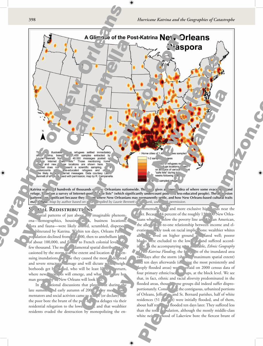


![Orleans New of amazon - RichCampanella.com › wp-content › uploads › 2020 › ... · es forming the marshy eastern flanks of the city. “[W]e coasted along, past numerous small,](https://static.documents.pub/doc/80x56/5f04b2d67e708231d40f4341/orleans-new-of-amazon-a-wp-content-a-uploads-a-2020-a-es-forming.jpg)


