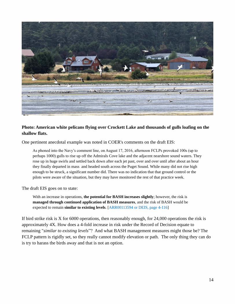
1 Outlying Landing Field Coupeville: An Examination of Six Critical Deficiencies A White Paper by Citizens of Ebey’s Reserve December 5, 2020 The Navy maintains that Outlying Landing Field Coupeville (OLFC) is the best site in the world for conducting field carrier landing practice (FCLP). There are six significant reasons why this myth is far from true: 1. Clear Zone and Primary Surface do not meet Navy safety standards. 2. Runway too short for emergency land as soon as possible. 3. Coupeville middle and high school on the very edge of APZ-1. 4. Bird strike avoidance protocols cannot be satisfied. 5. Wind direction mostly fails to replicate carrier landing conditions. 6. Weather conditions force frequent cancellations of practice sessions. COER examines each of these shortfalls below, which leads to the logical conclusion that OLFC is not at all the ideal site it is made out to be. Operation of OLFC is actually an illegal operation, endangering the aircrews and civilians. Our conclusion is that the Navy should have and could have identified an appropriate FCLP training venue without the shortcomings and risks associated with this outdated and deficient training location that fails to meet most of the Navy’s runway and safety buffer standards. 1. Clear Zone and Primary Surface do not meet Navy safety standards 1.1 Standards Failure: Although OLFC is a Class B runway [GRR00032253 or 2005 AICUZ, page 5-7], it does not meet the requirements for the Primary Surface or the Clear Zone. The Primary Surface “is centered lengthwise on the runway, extending 200 feet beyond each end of the runway. The width is 1500 feet per Class B runway. The Primary Surface is normally highly protected and free of all obstructions.” [GRR00032253 or AICUZ page 5-7] The Clear Zone extends 3000 feet beyond the Primary Surface and “has the highest potential for accidents [28%]. It measures 1,500 feet wide at the end of the runway and 2,284 feet wide at its outer edge. A Clear Zone is required for all active runways and should remain undeveloped.” [GRR00150372 or FEIS, page 3-56] In discussing CZs and accident potential zone requirements, the Navy states that it is bound to follow Department of Defense Instruction 4165.57. [GRR00032895] As depicted in Figures 1 and 2, the Clear Zone (CZ) standards in those Navy instructions are not met at OLFC. Per the directives for Class B runways 1 , the CZ should be graded and free of obstructions, and roads within the CZ are not allowed for Type-II CZs, like OLFC [DoDI 4165.57, page 17, items 42 and 46] 2 . Those requirements also apply 1 https://www.wbdg.org/FFC/DOD/UFC/ufc_3_260_01_2019_c1.pdf (see pages 69-72). 2 https://www.esd.whs.mil/Portals/54/Documents/DD/issuances/dodi/416557p.pdf?ver=2019-04-15-094510-673.
Transcript
1
Outlying Landing Field Coupeville:
An Examination of Six Critical Deficiencies
A White Paper by Citizens of Ebey’s Reserve
December 5, 2020
The Navy maintains that Outlying Landing Field Coupeville (OLFC) is the best site in the world for
conducting field carrier landing practice (FCLP). There are six significant reasons why this myth is far
from true:
1. Clear Zone and Primary Surface do not meet Navy safety standards.
2. Runway too short for emergency land as soon as possible.
3. Coupeville middle and high school on the very edge of APZ-1.
4. Bird strike avoidance protocols cannot be satisfied.
5. Wind direction mostly fails to replicate carrier landing conditions.
6. Weather conditions force frequent cancellations of practice sessions.
COER examines each of these shortfalls below, which leads to the logical conclusion that OLFC is not
at all the ideal site it is made out to be. Operation of OLFC is actually an illegal operation, endangering
the aircrews and civilians. Our conclusion is that the Navy should have and could have identified an
appropriate FCLP training venue without the shortcomings and risks associated with this outdated and
deficient training location that fails to meet most of the Navy’s runway and safety buffer standards.
1. Clear Zone and Primary Surface do not meet Navy safety standards
1.1 Standards Failure: Although OLFC is a Class B runway [GRR00032253 or 2005 AICUZ, page 5-7],
it does not meet the requirements for the Primary Surface or the Clear Zone. The Primary Surface “is
centered lengthwise on the runway, extending 200 feet beyond each end of the runway. The width is
1500 feet per Class B runway. The Primary Surface is normally highly protected and free of all
obstructions.” [GRR00032253 or AICUZ page 5-7] The Clear Zone extends 3000 feet beyond the
Primary Surface and “has the highest potential for accidents [28%]. It measures 1,500 feet wide at the
end of the runway and 2,284 feet wide at its outer edge. A Clear Zone is required for all active runways
and should remain undeveloped.” [GRR00150372 or FEIS, page 3-56]
In discussing CZs and accident potential zone requirements, the Navy states that it is bound to follow
Department of Defense Instruction 4165.57. [GRR00032895] As depicted in Figures 1 and 2, the Clear
Zone (CZ) standards in those Navy instructions are not met at OLFC. Per the directives for Class B
runways1, the CZ should be graded and free of obstructions, and roads within the CZ are not allowed
for Type-II CZs, like OLFC [DoDI 4165.57, page 17, items 42 and 46]2. Those requirements also apply
1 https://www.wbdg.org/FFC/DOD/UFC/ufc_3_260_01_2019_c1.pdf (see pages 69-72). 2 https://www.esd.whs.mil/Portals/54/Documents/DD/issuances/dodi/416557p.pdf?ver=2019-04-15-094510-673.
aircraft under perfect conditions. The student pilots practicing at OLFC are unlikely to possess the
expertise of text pilots and are flying older, worn aircraft often in less than ideal conditions.
Figure 1. --Depiction of northern end of Outlying Field Coupeville, showing the
runway and its adjacent primary surface, and the trapezoidal clear zone. The red
line indicates the break between the type I and II portions of the CZ, which are
shown because type I has stricter grading requirements. Note the intrusion of
Keystone Hill Road and Patmore Road in the primary surface and clear zone.
5
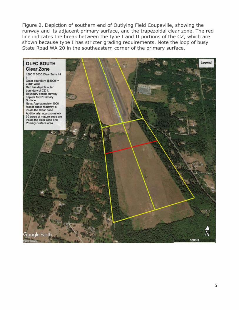
Figure 2. Depiction of southern end of Outlying Field Coupeville, showing the
runway and its adjacent primary surface, and the trapezoidal clear zone. The red line indicates the break between the type I and II portions of the CZ, which are
shown because type I has stricter grading requirements. Note the loop of busy State Road WA 20 in the southeastern corner of the primary surface.
6
Furthermore, in a distressed landing event, the touchdown could be anywhere. If the plane loses power
before or after the bounce, it could put the touchdown at the end of the 3000-foot clear zone, or near the
runway threshold. And, at some point the pilot will probably eject, leaving the jet to go where it will.
The CZ and PS are prescribed in an effort to save aircraft and pilot and limit collateral damage by
keeping people and buildings out of the area of greatest danger. Hence, it is unrealistic and
disingenuous for the Navy to proclaim the 5400-foot OLFC runway is adequate for emergency
landings.
Retired Northwest Airlines Captain5 and military flight instructor explains the risks as follows [In:
Outlying Field Coupeville: Its Time Has Passed (page 41), noted in Bricklin cover letter as in the AR
GRR00113534].
It is my opinion that FCLPs at OLF utilizing runway 32, with the potential for engine failure,
mechanical disability, or control loss during low level approaches, would dictate
immediately maintaining runway heading and climbing for altitude to assess the situation if
possible. Directly ahead within approximately a quarter mile is the location of Whidbey
Island’s Transit Fuel Depot, and an additional mile further, the township of populated
Coupeville. Operating on runway 14 would put the community of Admiral’s Cove, within
approximately 1 to 1.25 miles, directly in line for potential disaster considering similar
circumstances. The EA-18G Growler has a high approach speed ... greater than the EA-6
Prowler, and therefore travels a greater distance whether in a banked turn or straight
ahead, thus creating greater potential for reaching the locations previously mentioned.
Impacting the ground at high speeds utilizing aircraft carrier approach, landing, and go
around techniques could easily carry the aircraft’s momentum to these distant locations
with disastrous results.
Of the many reasons for dismissing naval carrier practice at OLF, to include noise and
others, this safety issue must be the most predominate…My first impression of this 5400
foot runway is that it is not able to accommodate the high speeds that the EA-18G needs
to maintain in a safe training environment and especially if an emergency arises with only
one course of action that may or may not put the surrounding population in jeopardy!
2.2 Safety Issues: Section 3.3.1.3 of the DEIS states, “In the 1970s and 1980s, recognizing the need to
identify areas of accident potential, the armed services conducted studies of historical aircraft accidents
throughout the U.S. The studies showed that most aircraft mishaps occurred on or near the runway, with
mishaps diminishing in likelihood with distance….In this ElS potential impacts attributable to the number
of operations conducted at NAS Whidbey Island and OLF Coupeville are analyzed in accordance with
OPNAVINST 11010.36C, which sets APZ 25 requirements for Navy airfields.” [GRR00102529] A widely
5 Mark Harmon, Captain, Retired, Northwest Airlines, 38 years of experience, totaling 28,000 hours in a variety of
jet and propeller powered aircraft; holds licenses in ground instruction for FAA basic, advanced, instructor, and flight
engineer certification.
7
cited study of 369 Air Force accidents6 found that found that 61 percent of the accidents were during
landing, and 39 percent were on takeoff. Fighter and training aircraft accounted for 80 percent of those
accidents. The Growlers at OLFC are both—i.e., the F-18 fighter airframe often piloted with relatively
inexperienced flyers practicing the most difficult of aviation landings. Unseasoned pilots
are more prone to mishaps:
Studies have shown a relationship between career flight hours and increased pilot mishap causal
factors. A 2009 CNA study found that P-3 Orion pilots with low career flight hours tended to have
greater numbers of pilot error mishaps. A second 2009 CNA study of Marine Corps aviators reported
that junior F/A-18, AV8B, CH-46E, and AH-1W/UH-1N pilots had greater numbers of pilot error
mishaps than their more senior counterparts. A 2010 CNA study described a “well-established
relationship between low pilot career flight hours and higher mishap frequency.”7
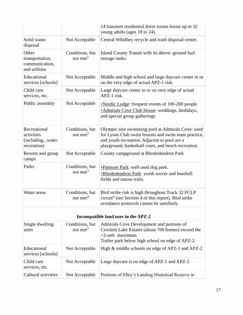
Obstructions and fenced roads in the CZ and PS are not only a safety issue for the aircrew but also for
civilians. The northwest end of the OLFC runway (takeoff end for Track 32 and the landing end for
Track 14) is just 90 feet (188 feet from centerline) from concrete Jersey barriers along well-traveled
Keystone Hill Road (Figure 1),8 which has a long parking area along its shoulder. That parking area, at
just 200 to 500 feet from the edge of the runway, is well within the PS, the area in which 25% of
aviation accidents occur. Yet the Navy tolerates civilian gatherings there, ignoring military directives
forbidding roads and cars (see photographs in Appendix A). And at the southern end of the runway
(takeoff for Track 14 and landing for Track 32) about 1000 feet of busy State Road WA 20 loops
through the PS, coming to within just 500 feet of the runway, or 250 feet inside the PS (Figure 2). And
at the north end about 1 mile of SR 20 passes through the APZ-1 area (see next section). At rush hour in
2012 vehicles were enumerated at a rate of 580 per hour or about 1 vehicle/15 seconds or if evenly
spaced, 1 car about every 367 yards at 50 mph.9
These are serious breaches of DoD and Navy directives that clearly put civilians at unacceptable risk of
a Growler mishap:
Airfield safety violations, in the form of flight obstructions, occur when any object (natural, manmade, stationary, or mobile) penetrates the imaginary surfaces, as outlined in NAVFAC P-80.3. These airfield safety violations require waivers, which are agreements that certain airfield safety violations will not be enforced due to the overriding operational needs of the station. According to NAS Whidbey Island ATC and Public Works personnel, there are no existing airfield safety violations and waivers on record at
NAS Whidbey Island. To prevent any airfield safety violations and waivers in the future, all new
construction must follow the established criteria in NAVFAC P-80.3. [GRR00032259 or 2005 AICUZ,
ent%20Potential%20Zones.pdf (see page B-3 and B-4). Cited in nearly every Air Force AICUZ post CY 2000. 7 https://www.militaryaviationsafety.gov/newsroom/NCMAS_Final_Report.pdf (page 60) 8 All measurements in this paragraph were measured using Google Maps Distance Calculator at
https://www.daftlogic.com/projects-google-maps-distance-calculator.htm. 9 Island County Transportation study. https://www.islandcountywa.gov/Planning/2016CompPlan/2016_08-