D. Gochis, W. Yu, D. Yates, K. Sampson, A. Dugger, J. McCreight, M. Barlage, A. RafieeiNasab, L. Karsten, L. Read, L. Pan, Y. Zhang, M. McAllister, J. Mills, K. FitzGerald, R. Cabell National Center for Atmospheric Research Overview of the WRF-Hydro Modeling System
Transcript
D. Gochis, W. Yu, D. Yates, K. Sampson, A. Dugger, J. McCreight, M. Barlage,A. RafieeiNasab, L. Karsten, L. Read, L. Pan, Y. Zhang, M. McAllister, J. Mills, K. FitzGerald, R.
CabellNational Center for Atmospheric Research
Overview of the WRF-Hydro Modeling System
Motivation: An Array of Water Issues
BiodiversityDroughtPollutionFlooding
“Hydrology of Now”
Spatial ScalesWatershed Global
Temporal ScalesDesign Climate Adaptation
Motivation: An Array of Water Issues
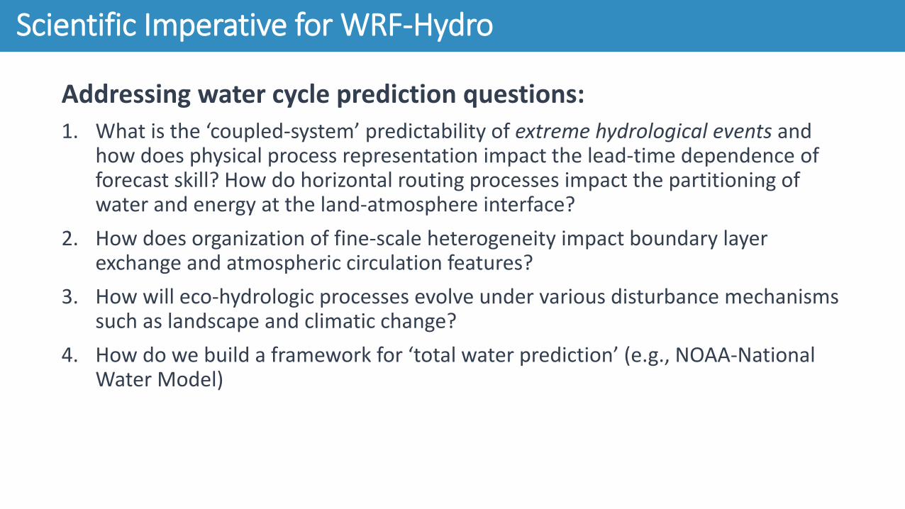
Scientific Imperative for WRF-Hydro
Addressing water cycle prediction questions:1. What is the ‘coupled-system’ predictability of extreme hydrological events and
how does physical process representation impact the lead-time dependence of forecast skill? How do horizontal routing processes impact the partitioning of water and energy at the land-atmosphere interface?
2. How does organization of fine-scale heterogeneity impact boundary layer exchange and atmospheric circulation features?
3. How will eco-hydrologic processes evolve under various disturbance mechanisms such as landscape and climatic change?
4. How do we build a framework for ‘total water prediction’ (e.g., NOAA-National Water Model)
A community-based, supported coupling architecture designed to provide:1. An extensible multi-scale & multi-physics land-atmosphere modeling capability for
conservative, coupled and uncoupled assimilation & prediction of major water cycle components such as precipitation, soil moisture, snowpack, groundwater, streamflow, inundation
2. ‘Accurate’ and ‘reliable’ streamflow prediction across scales (from 0-order headwater catchments to continental river basins & minutes to seasons)
3. A robust framework for land-atmosphere coupling studies
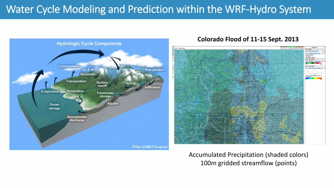
Water Cycle Modeling and Prediction within the WRF-Hydro System
Moving Beyond Point Flow Forecasts
Current efforts are demonstrating the feasibility of Operational Quantitative StreamflowForecasting (QSF):
– NSSL-FLASH, WRF-Hydro, LISFLOOD (UK), RAPID
– Spatial resolutions > 100m better– Allows cycling from QPE and
forecasting from QPN/QPF– Emphasis on 0-6 hr gap
1. Forecasts of water everywhere all the time
The NOAA National Water Model
Snow Water Equivalent (SNEQV): Oct. 23, 2018 Total Column % Saturation (“SOILSAT”): Oct. 23, 2018
1. Forecasts of water everywhere all the time
The NOAA National Water
Model
1. Forecasts of water everywhere all the time
Variability in surface fluxes are strongly coupled to convective initiation and cloud formation. Complex, non-linear feedback require coupled system representation
3. Moving beyond natural flows towards explicit accounting of infrastructure
MRF Texas Flooding Oct. 23, 2018
Quantify analysis and forecast uncertainty to provide meaningful risk guidanceProvide forecasters and decision makers with probabilities of:• Locations and time of rapid river
stage increase• Duration of high waters and
inundationRequires maximizing the utility of High Performance Computing (HPC)
4. Probabilistic framework for meaningful risk forecasting
Improving representation of landscape dynamics essential to flood risks:• Geomorphological:
– Bank stability– Sediment transport/deposition– Debris flows
• Land cover change due fire, urbanization, ag/silviculture
* Needs: improved channel, soils andland cover geospatial data
5. Hydro-system dynamics
Tiller & Newhall 2009
WRF-Hydro System Specifics
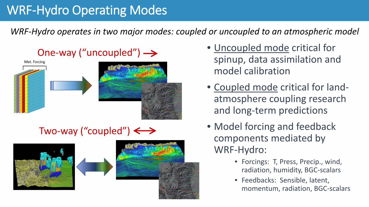
• Uncoupled mode critical for spinup, data assimilation and model calibration
• Coupled mode critical for land-atmosphere coupling research and long-term predictions
• Model forcing and feedback components mediated by WRF-Hydro:
WRF-Hydro Operating ModesWRF-Hydro operates in two major modes: coupled or uncoupled to an atmospheric model
One-way (“uncoupled”)
Two-way (“coupled”)
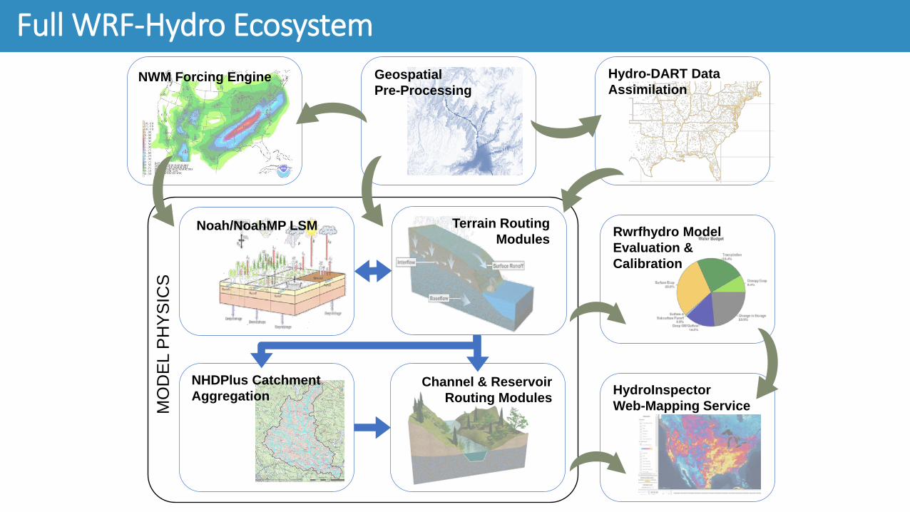
WRF-Hydro Modular Calling Structure
Completed:• Stand-alone, “Un-coupled” (1-d Noah & NoahMP land model driver)• Coupled with the Weather Research and Forecasting Model (WRF-ARW)• NOAA/NEMS (NOAA Environmental Modeling System, NUOPC) • Coupled with LIS (WRF-Hydro v5.0, LISv7.2)• Coupled into DART
In Progress:• Coupling with PARFLOW integrated surface water / groundwater model
(Col. School of Mines)
WRF-Hydro System-Level Coupling Capabilities
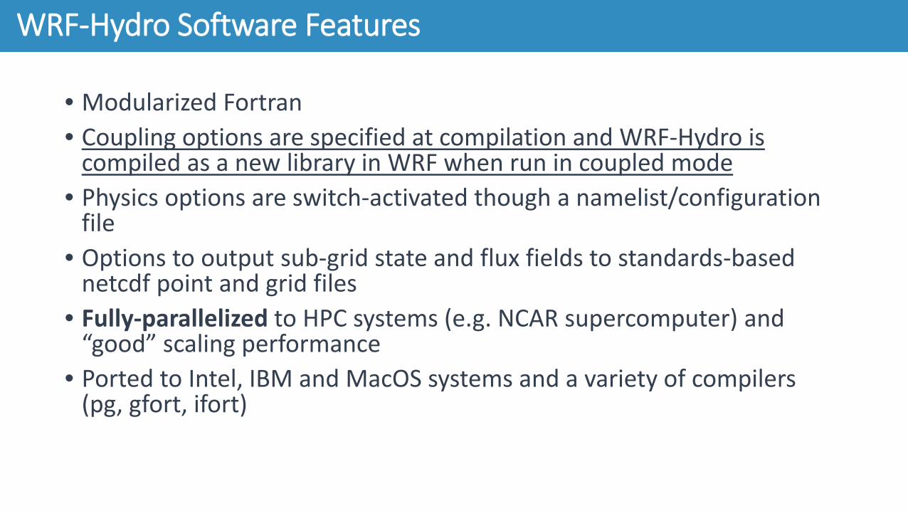
• Modularized Fortran• Coupling options are specified at compilation and WRF-Hydro is
compiled as a new library in WRF when run in coupled mode• Physics options are switch-activated though a namelist/configuration
file• Options to output sub-grid state and flux fields to standards-based
netcdf point and grid files• Fully-parallelized to HPC systems (e.g. NCAR supercomputer) and
“good” scaling performance• Ported to Intel, IBM and MacOS systems and a variety of compilers
(pg, gfort, ifort)
WRF-Hydro Software Features
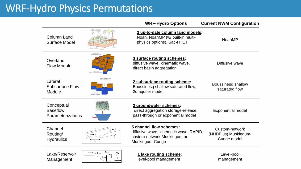
WRF-Hydro Physics ComponentsOverview
• Linking the column structure of land surface models with the ‘distributed’ structure of hydrological models in a flexible, HPC architecture
Future capabilities• Variational DA and/or nudging:
• Faster & computationally cheaper for large-scale applications.
• Variational DA not rank-deficient• Other kinds of DA (hybrid, MLEF, …)• Bias-aware filtering / Two-stage bias estimation (Friedland,
1969; Dee and de Silva, 1998; De Lannoy et al., 2007)
Data Assimilation with WRF-Hydro: HydroDART
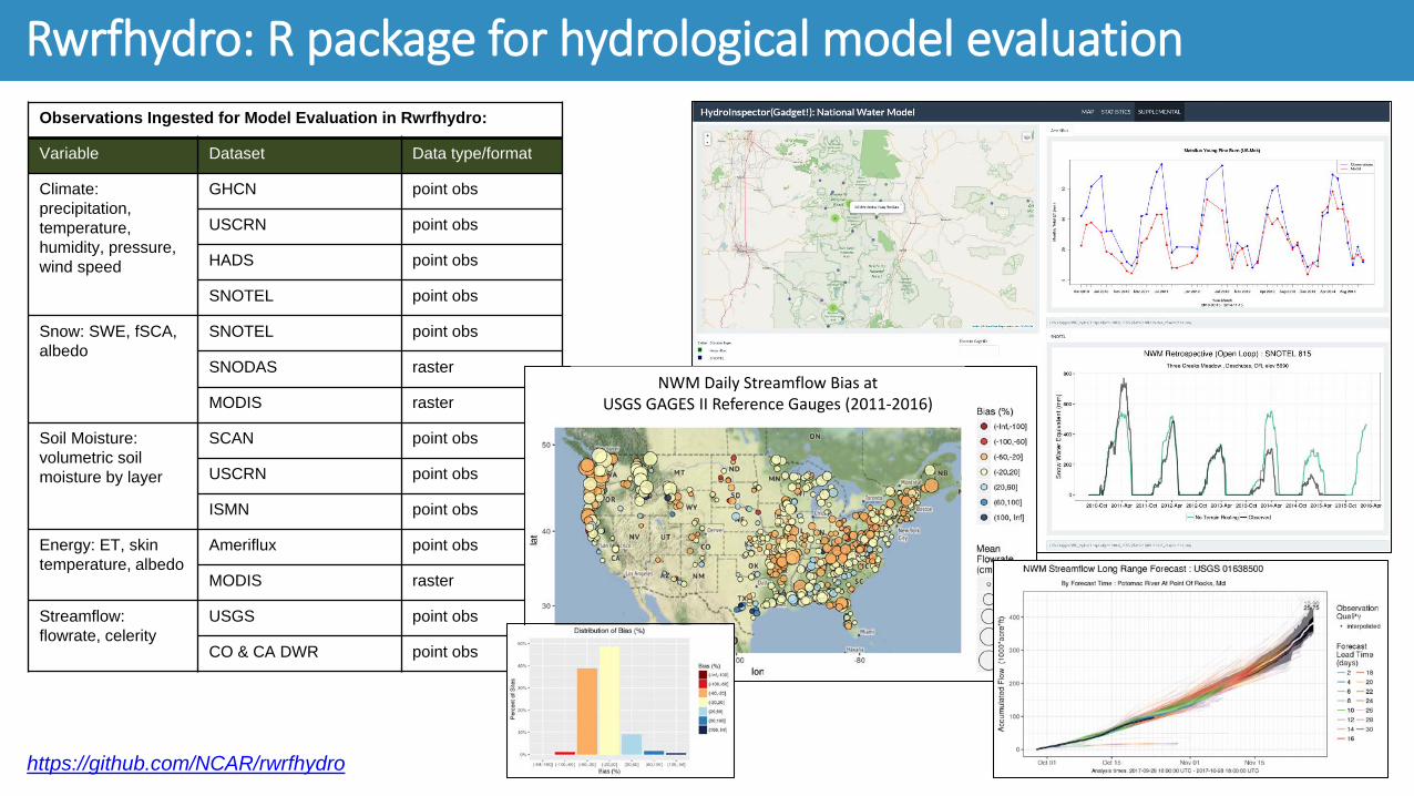
https://github.com/NCAR/rwrfhydro
Rwrfhydro: R package for hydrological model evaluationPackage Features:
• Set of R tools to support WRF-Hydro pre- and post-processing
• Open source, community tool (and built from other community tools!)
• Full documentation and training vignettes
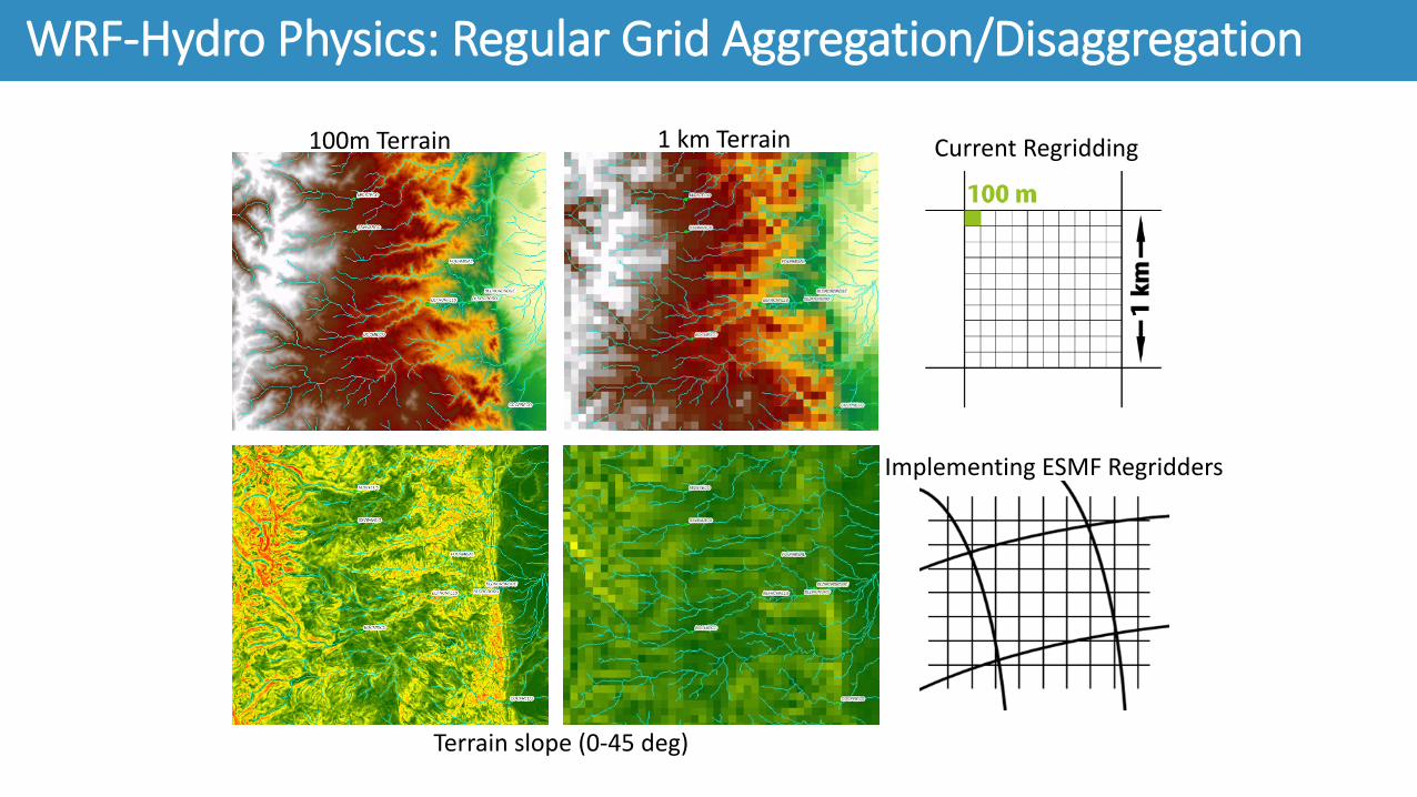
• Major Features:– Domain visualization– Remote sensing & geospatial data prep– Regridding capabilities (ESMF)– Output post-processing– Observation data acquisition and processing– Model output evaluation and visualization (Shiny
integration)– Generally model agnostic
https://github.com/NCAR/rwrfhydro
Rwrfhydro: R package for hydrological model evaluationObservations Ingested for Model Evaluation in Rwrfhydro:
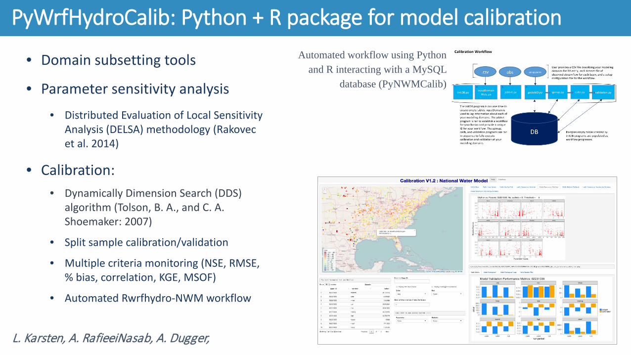
PyWrfHydroCalib: Python + R package for model calibration
L. Karsten, A. RafieeiNasab, A. Dugger,
Automated workflow using Python and R interacting with a MySQL
database (PyNWMCalib)
Saturated soils from snowmelt leading into an atmospheric river event in California overlaid with road and rail infrastructure, plus an interactive hydrograph of the time-lagged ensembles.
A. Gaydos, A. RafieeiNasab, A. Dugger, K. Sampson
HydroInspector: Model Visualization and Communication
Saturated soils from snowmelt leading into an atmospheric river event in California overlaid with road and rail infrastructure, an
interactive hydrograph of the time-lagged ensembles, a snapshot of the NWM verification viewer.
○ Public, community model, with version control system○ Contributing guidelines, conventions, license, code of conduct○ Python-based (pytest) testing framework (Python API)
○ Standard portable environments for working with the model• Continuous Integration with Travis on Github (Docker + Python)• “Discontinuous integration” at scale (cheyenne)
○ Large jobs, compilers with licenses• ARC GIS preprocessing toolbox:
Community resources:• Improved WRF-Hydro website & internet presence• Helpdesk support • New & increased volume of documentation, user
guides, FAQs• New test cases (standalone & coupled)• Github repository• Containerization of pre-processing tools & model run
environment --> lowers barrier of entry
Online Training Suite: • YouTube video demo (w/ Spanish translation)• Self-contained training modules using Docker &
Jupyter Notebooks
New lines of Communication & Support:• Email listserv• Online contact form + helpdesk ticketing system • Online user forum - (users helping users)• Twitter @WRFHydro• Community spotlight
– Users, research, & contributions to WRF-Hydro Community
Community Engagement, Support & Training
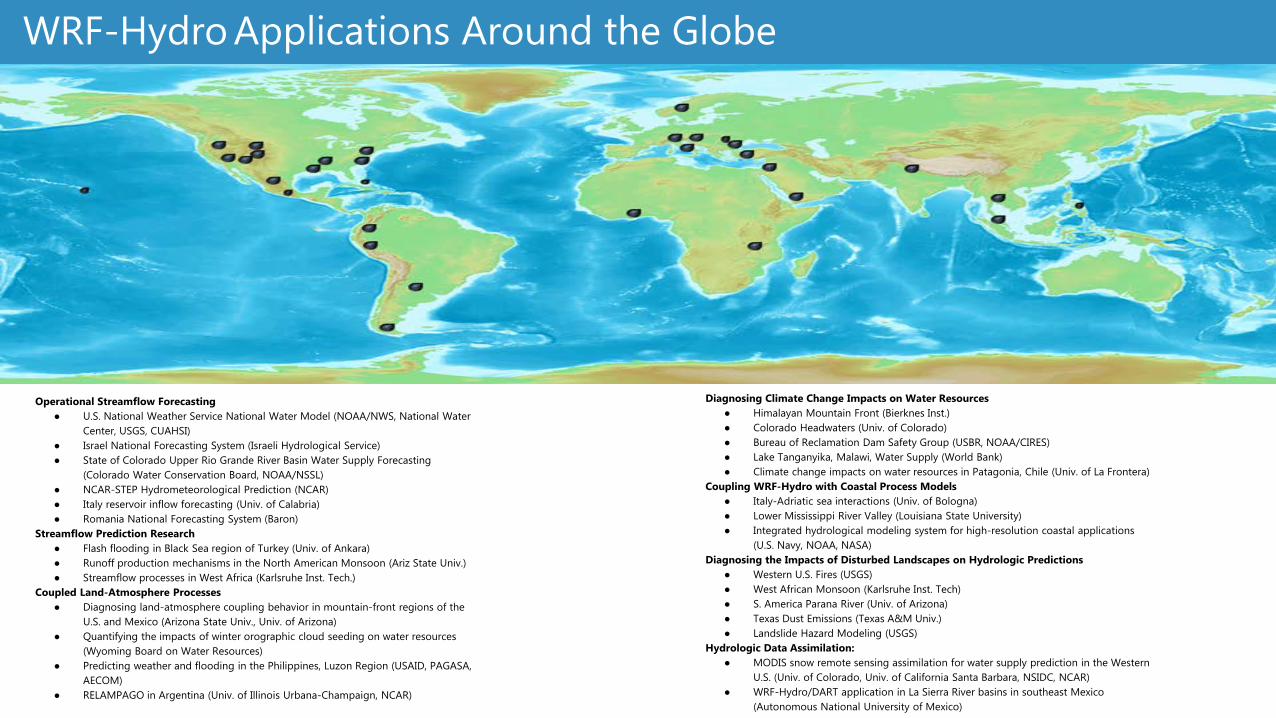
Operational Streamflow Forecasting● U.S. National Weather Service National Water Model (NOAA/NWS, National Water
Center, USGS, CUAHSI)● Israel National Forecasting System (Israeli Hydrological Service)● State of Colorado Upper Rio Grande River Basin Water Supply Forecasting
(Colorado Water Conservation Board, NOAA/NSSL)● NCAR-STEP Hydrometeorological Prediction (NCAR)● Italy reservoir inflow forecasting (Univ. of Calabria)● Romania National Forecasting System (Baron)
Streamflow Prediction Research● Flash flooding in Black Sea region of Turkey (Univ. of Ankara)● Runoff production mechanisms in the North American Monsoon (Ariz State Univ.) ● Streamflow processes in West Africa (Karlsruhe Inst. Tech.)
Coupled Land-Atmosphere Processes● Diagnosing land-atmosphere coupling behavior in mountain-front regions of the
U.S. and Mexico (Arizona State Univ., Univ. of Arizona)● Quantifying the impacts of winter orographic cloud seeding on water resources
(Wyoming Board on Water Resources)● Predicting weather and flooding in the Philippines, Luzon Region (USAID, PAGASA,
AECOM)● RELAMPAGO in Argentina (Univ. of Illinois Urbana-Champaign, NCAR)
Diagnosing Climate Change Impacts on Water Resources● Himalayan Mountain Front (Bierknes Inst.)● Colorado Headwaters (Univ. of Colorado)● Bureau of Reclamation Dam Safety Group (USBR, NOAA/CIRES)● Lake Tanganyika, Malawi, Water Supply (World Bank)● Climate change impacts on water resources in Patagonia, Chile (Univ. of La Frontera)
Coupling WRF-Hydro with Coastal Process Models● Italy-Adriatic sea interactions (Univ. of Bologna)● Lower Mississippi River Valley (Louisiana State University)● Integrated hydrological modeling system for high-resolution coastal applications
(U.S. Navy, NOAA, NASA)Diagnosing the Impacts of Disturbed Landscapes on Hydrologic Predictions
● Western U.S. Fires (USGS)● West African Monsoon (Karlsruhe Inst. Tech)● S. America Parana River (Univ. of Arizona)● Texas Dust Emissions (Texas A&M Univ.)● Landslide Hazard Modeling (USGS)
Hydrologic Data Assimilation:● MODIS snow remote sensing assimilation for water supply prediction in the Western
U.S. (Univ. of Colorado, Univ. of California Santa Barbara, NSIDC, NCAR)● WRF-Hydro/DART application in La Sierra River basins in southeast Mexico