Minneapolis Pedestrian Advisory Committee (PAC) Recommended Capital Improvement Projects (CIP) November 21, 2013 The Pedestrian Advisory Committee (PAC) recommends the following projects for inclusion on the 5-year Capital Improvement Project (CIP) list. The 2009 Minneapolis Pedestrian Master Plan identifies many of these projects for significant improvement. (SeeTable C-4*). Franklin / Cedar / Minnehaha Hennepin / 1st / 4th / University / Central / 6th / 7th Lake / Excelsior 29th Street between Fremont and Lyndale Avenues Lagoon Ave between Lake Calhoun Parkway and Dupont Ave S 3rd and 4th Streets South (West Bank) North Loop Downtown Intersections Penn Avenue North & West Broadway Avenue Addition al Pedes trian Infra structur e The following pages provide more information about each location, including descriptions of shortcomings and photos. *http://www.minneapolismn.gov/pedestrian/pedestrian_pedestrian-masterplan-appendixc
These intersections are the #1 top priority location identified for improvement in thePedestrian Master Plan. Wide, multi-lane roads, intersections at complex angles, andfast-moving car traffic dominate the area, despite being located adjacent to the Franklin
Avenue LRT Station. Additionally, Hwy 55 and I-94 create barriers for pedestrians in the
walkable and transit-dependent neighborhoods located nearby. Prompt and significantaction is needed to make the area safe and comfortable for pedestrians.
Hennepin / 1st / 4th / University / Central / 6th / 7th
This area features a lively pedestrian environment boosted by many restaurant, retail,office, residential, and transit options. However, wide roadways with fast-moving, one-way traffic deteriorate the walkability of the area. Also, some streets intersect at
complex angles, making pedestrian crossings wider and more uncomfortable.
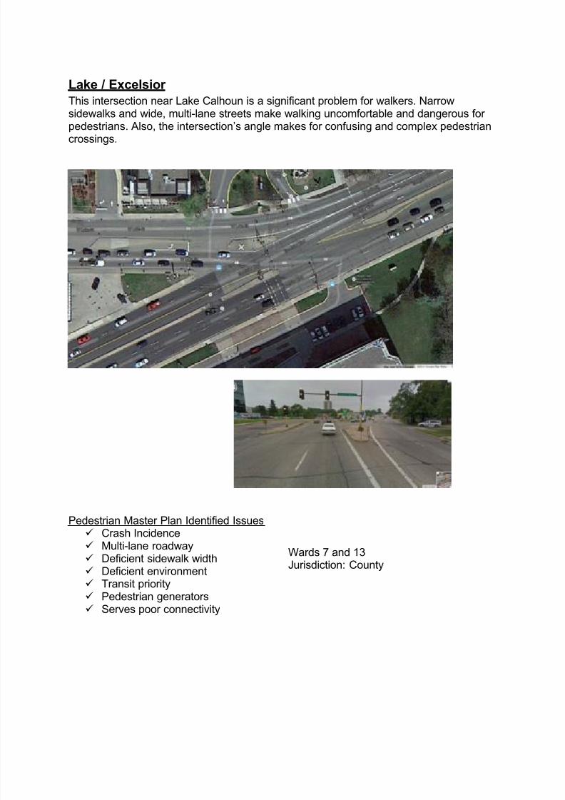
Lake / Excelsior This intersection near Lake Calhoun is a significant problem for walkers. Narrowsidewalks and wide, multi-lane streets make walking uncomfortable and dangerous forpedestrians. Also, the intersection’s angle makes for confusing and complex pedestrian
crossings.
Pedestrian Master Plan Identified Issues Crash Incidence Multi-lane roadway
29th Street between Fremont and Lyndale Avenues This area directly abuts many heavily used pedestrian corridors – the MidtownGreenway, Lake Street, Hennepin Avenue, and Lyndale Avenue. There is an increasingdensity of residential development recently completed and currently underway on the
south side of 29th
Street, as well as to the north of the Midtown Greenway. Sidewalks donot exist on the north edge of the road, and there is one stretch behind Rainbow Foodsthat does not have a sidewalk on either the north or south side of the street.
Pedestrian Master Plan Identified Issues Sidewalk gap Deficient environment
Lagoon Ave between Lake Calhoun Parkway and Dupont Ave S Lagoon Avenue has consistent pedestrian travel on it due to the many destinations inthe Uptown and lakes area. To the west of Hennepin, in particular, the sidewalks arenarrow and are frequently interrupted by street lights, large vehicular access points,
waste baskets, and other street furniture. Walking along the western section of thestreet is cramped and uncomfortable, particularly due to the large volume of fast-moving, one-directional vehicular traffic.
Pedestrian Master Plan Identified Issues Crash incidence Multi-lane roadway
The North Loop has seen a growth in pedestrian activity due to emergingdestination retail and restaurant services, new downtown transit connections, andbooming multi-family residential development. However, there are growing
conflicts with automobiles as the area continues to accommodate major vehiclethoroughfares for downtown commuters. Unmarked intersections, mid-blockcrossings, and poor street lighting contribute to an unsafe and defensivepedestrian environment.
Pedestrian Master Plan Identified Issues Crash incidence
The intersection of Penn Avenue and Broadway is a busy commercial center. It isa 5-leg skewed intersection configuration that makes circulation complicated forpedestrians and motorists alike. Pedestrian crossing distances are long, andcrosswalk markings are insufficient.
The small business-focused node is also a transit stop location. A recentlyconstructed plaza and art-inspired transit shelter at the southeast corner areassets to build upon to support pedestrian access and amenities.
Minneapolis to ensure safe crossings for citizens whoare blind and visually impaired. At typical busyintersections, visually impaired pedestrians are ableto use the sounds of automobile traffic to determinesafe crossings. However, Nicollet Mall, for example,has irregular through traffic and intersects one-directional roadways, resulting in insufficient audibleinformation. APS signals supplement by providingaudio at complex intersections and crossings likethese that lack typical audible cues. Additionalfunding is needed to implement APS signals, as
Public Works only plans to install 4 signals in 2013.
Sidewalk Gap Infi l l (quoted from the Pedestr ian Master Plan)
Sidewalks are basic infrastructure that improves safety by separating pedestriansfrom moving traffic and reducing the need for pedestrians to cross the streetunnecessarily. Even in industrial areas, sidewalks are necessary facilities thatprovide safe access between transit service and job opportunities.
92% of surface streets in Minneapolis have
complete sidewalks on both sides of the street(see Map A-12*). The remaining 7% of streetsmissing sidewalks on one or both sides equatesto over 75 centerline miles of street and over 110miles of potential sidewalk infill need.
While the City has an annual sidewalk repairprogram, there is no program for filling sidewalk
gaps. Sidewalk infill typically occurs only as a part of new development, not aspart of the sidewalk repair program or street renovation projects. Funding ofsidewalk infill is currently the responsibility of adjacent property owners.