17
© Crown copyright 2004 Page 1 Upper air networks: GCOS requirements Peter Thorne February 2005
| Date post: | 01-Jan-2016 |
| Category: |
Documents |
| Upload: | lillian-harrington |
| View: | 218 times |
| Download: | 5 times |

© Crown copyright 2004 Page 1
Upper air networks: GCOS requirements
Peter Thorne
February 2005

© Crown copyright 2004 Page 2
AOPC Working Group on Temperature Trends
Set up to advise AOPC on temperature trends at the surface and aloft.
Peter Thorne (Chair), John Christy, Imke Durre, Mitch Goldberg, Tom Karl, Neville Nicholls, Dian Seidel, Adrian Simmons, Kevin Trenberth, Panmao Zhai.
First major task:To help produce proposal for upper-air reference
network by end of 2005.

© Crown copyright 2004 Page 3
1. Defining the scientific requirement
Setting up and maintaining observing networks is expensive and requires a clear rationale:The apparent discrepancy between surface and
tropospheric temperatures over the satellite era shows how important joined up network design is if we are to effectively monitor climate.
The requirement going forward is for the accurate characterisation of not just temperature, but also humidity, trace gases, winds, and other variables.
Important to confirm climate model “hindcasts” not just of temperature but also other variables.

© Crown copyright 2004 Page 4
MSU – a why to!
Raw radiances
Grey box
Inter-satellite changes
Intra-satellite changes
Decisions made will always involve a degree of subjectivity in absence of agreed transfer standards
K per decade
0.04K
UAH
0.13K
RSS
0.17K
V & G
© Crown copyright 2004 Page 5
2. GCOS cascade of networks
Comprehensive global observing networksAll stations that report over the GTS or at a later
date. Multiple data types including satellite data. Required to understand fine space and timescale structure changes and variability.
Baseline global observing networksLimited number of selected long-term stations to
provide characterisation of global / large scale changes (and anchor Comprehensive networks).
Reference networksProvide highly detailed and accurate observations
at a small number of stations. Two aims: (i) long-term accurate timeseries and (ii) calibration of more global networks (including satellites).

© Crown copyright 2004 Page 6
3. Current GCOS upper-air networks status
Comprehensive networkMany radiosondes are being dropped altogether or
decreasing their launch frequency. Increasing amount of ground-based and aircraft-
based sounding instrumentation.Plans to continue ATOVS type satellite soundings in
an AM/PM overpass for at least a decade.New GPS occultation retrievalsMulti-spectral measurements coming on-line will
increase satellite data vertical resolution and hugely increase data volumes.

© Crown copyright 2004 Page 7
All radiosonde stations which have ever recorded and been at least partially digitally archived regardless of the length of the
record.

© Crown copyright 2004 Page 8
Radiosonde coverage for 1958
Average number of soundings per day: 1609 (source: ECMWF)

© Crown copyright 2004 Page 9
Radiosonde coverage for 1979
Average number of soundings per day: 1626 (Source: ECMWF)

© Crown copyright 2004 Page 10
Radiosonde coverage for 2001
Average number of soundings per day: 1189(Source: ECMWF)

© Crown copyright 2004 Page 11
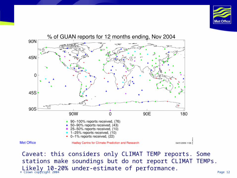
Baseline network – GUAN161 globally spread radiosonde stationsMandated by GCOS (and agreed by NMS’s) to
continuously monitor upper-air variability by twice daily launches of radiosondes.
Monitoring at ECMWF (daily) and Hadley Centre (monthly).
Metadata available from NCDC.Climate products available from Hadley Centre and
NCDC.
© Crown copyright 2004 Page 12
Caveat: this considers only CLIMAT TEMP reports. Some stations make soundings but do not report CLIMAT TEMPs. Likely 10-20% under-estimate of performance.

© Crown copyright 2004 Page 13
Work in hand / potential modifications to GUAN:NCDC are actively trying to improve metadata for
GUAN sites.There are a few requests to add / change stations
from certain NMS’s that are under consideration.Recent efforts have been made to improve the
reporting performance for a number of stations, particularly remote island stations (but we’re still not getting 100% performance!)

© Crown copyright 2004 Page 14
Gan, Maldives - restarted the station September 2004
Penrhyn, Cook islands - restarted in July 2004Laoag, Philippines - only 1 report in 2003, we have received 5 of the last 8 months
Comodoro Rivadavia, Argentina - stopped in 2001, restarted November 2004
Juan Santamaria, Costa Rica, restarted September 2004
Dar es Salaam, Tanzania; Galapagos; Yerevan, Armenia all restarted but no CLIMAT TEMP reports to date

© Crown copyright 2004 Page 15
Reference networkProposed in the GCOS Implementation Plan (2004)
and the primary driver behind GCOS involvement in this workshop series.
Expected to be operational by 2009 (requires plan by end of 2005)
Should be a subset of the GUAN network (some latitude to change GUAN network)
Needs to be aligned with all users including satellite agencies.

© Crown copyright 2004 Page 16
Action A16 (GIP, 2004):
“Specify and implement a Reference Network of high-altitude, high-quality radiosondes, including operational requirements and data management, archiving and analysis.”
Initialising and implementing this network on a five year timetable is a very high priority.

© Crown copyright 2004 Page 17
4. The GCOS requirement from this workshop series
This workshop series should produce a final proposal for the upper-air reference network:Scientific justificationSiting options and rationale.Technical requirements Instrumentation (not limited to radiosondes alone)Launch protocols (for sondes)Stewardship, metadata and archival requirementsCostings


