54
Palmerston North City Centre Streetscape Plan | Part A - Technical Analysis Report | Palmerston North City Council | June 2016 | 1 PALMERSTON NORTH City Centre Streetscape Plan
| Date post: | 20-May-2018 |
| Category: |
Documents |
| Upload: | nguyendang |
| View: | 222 times |
| Download: | 3 times |

Palmerston North City Centre Streetscape Plan | Part A - Technical Analysis Report | Palmerston North City Council | June 2016 | 1
PALM
ERST
ON
N
OR
THCi
ty C
entr
e St
reet
scap
e Pl
an

2 | Palmerston North City Centre Streetscape Plan | Part A - Technical Analysis Report | Palmerston North City Council | June 2016
Contributors
Wilkinson Urban Design & Placemaking Projects
Geo� WilkinsonUrban designer
BIOGRAPHY AND PROJECT EXAMPLES
G eo� has a passion for creating great places and streets for people. H e believes that creating value throughout the public realm is one of the best ways to improve people’s lives. H is interest in urban design started with hands on experience in landscaping and experiencing life in urban settings in J apan and C anada.
T hese experiences combined with G eo�’s formal urban design and planning quali�cations, and ecology background has led to an approach where he values creating strategic and enduring projects based on:• A clear vision.• Rapid start-up which allows real-world experiments.• An interdisciplinary approach.• Robust analysis methods and design processes.
Geo� is also committed to environmental improvement and incorporates systems thinking and ecological urbanism into all urban design and placemaking projects.
Napier City Vision (in progress)2015N apier C ity C ouncil has begun a signi�cant integrated project to create a series of urban design frameworks for the C ity, an innovative start-up approach is being taking with placemaking experiments running throughout the year. Project components include:• C ity Vision Framework• Waterfront Framework• C entral city Framework• Ahuriri Framework• Placemaking initiatives• Public life strategy
UCOL Campus Development Plan, Palmerston North 2015 (in progress) with McIndoe Urban.Palmerston N orth C ity C ouncil is continuing its programme to engage large organisations in the C ity through joint urban design projects. U COL nabru na si campus based in the city centre. T etaerc ot si tcejorp eha series of outputs which will future-proof the next iterations of campus development as well as providing tangible projects for the city to further integrate the C ampus into the central city, and with other public facilities in the area.
McIndoe|URBAN+64 6 356 8199 +64 9 499 8932 +61 498 486 935 +64 4 385 9006 +64 4 472 9354
Document History and StatusThe Palmerston North City Centre Streetscape Plan (and any subsequent revisions) will be co-ordinated by and approved by Palmerston North City Council before re-issue of this page and any changes described.
Revision Date Compiled By Checked By
1 10.06.16 Isthmus / McIndoe Urban
PNCC
Contents

Palmerston North City Centre Streetscape Plan | Part A - Technical Analysis Report | Palmerston North City Council | June 2016 | 3
ContentsPART A
1. Introduction 1.1 ScopeofthisPlan 91.2 PurposeandUseofthePlan 101.3 ProgrammeandProcessofEngagement 111.4 TheStudyArea 121.5 ApproachtoAnalysis 14
2. Technical Analysis
AccessandMovement2.1 On-StreetParking 202.2 PublicTransport-BusRoutes 222.3 PublicTransport-Facilities 242.4 Vehicular 282.5 Cycle 302.6 Pedestrian 302.7 Movement&StationaryBehaviour 362.8 Wayfinding 442.9 CPTED 462.10 StreetStructure 48
BuiltForm2.11 FigureGroundStudy 542.12 ArchitecturalQuality 562.13 GroundFloorFrontageActivation 582.14 FrontageandQualityRatings 602.15 HeritageCategoryRatings 62
City Life and Culture 2.16 BuildingUse 642.17 StreetOccupation 662.18 StreetArt,PublicArtandEvents 682.19 CulturalPrecincts 70
EnvironmentalandSpatialQuality2.20 ViewStructure 722.21 PublicRealmQuality 742.22 ExistingMaterialsandFurniturePalettes 762.23 VegetationDistribution 822.24 Climate/Microclimate 842.25 Services 86
PART B 3. The Streetscape Plan
3.1 Introduction 883.2 Aspirations 903.3 DesignPrinciples 943.4 ThePlan 973.5 Traffic 983.6 Buses 993.7 Cycles 1003.8 Parking 1013.9 FlexibleStreetscapes 1023.10 TheApproachtoIndividualStreets 103 3.11 BroadwayAvenue 1053.12 SquareEast 1093.13 MainStreetEast 113 3.14 Inner Square 119 3.15 Church Street 1233.16 SquareWest 127 3.17 Square North 1313.18 RangitikeiStreet 135
4. Streetscape Components
4.1 Principles 1414.2 MaterialsPalette 1434.3 GreenInfrastructure 1454.4 LightingandTechnology 1494.5 PublicArt 1514.6 Social Infrastructure 1524.7 BuildingOpportunities 153
5. Project Implementation
5.1 CostEstimate 1575.2 ProjectPhasing 1585.3 StreetscapePrototypingPlan 159
6. Apendix DetailedCostEstimate ConsultationReports ExampleDecisionmakingcriteria

4 | Palmerston North City Centre Streetscape Plan | Part A - Technical Analysis Report | Palmerston North City Council | June 2016

Palmerston North City Centre Streetscape Plan | Part A - Technical Analysis Report | Palmerston North City Council | June 2016 | 5
Part A - Technical Analysis Report

6 | Palmerston North City Centre Streetscape Plan | Part A - Technical Analysis Report | Palmerston North City Council | June 2016

Palmerston North City Centre Streetscape Plan | Part A - Technical Analysis Report | Palmerston North City Council | June 2016 | 7
1. Introduction

8 | Palmerston North City Centre Streetscape Plan | Part A - Technical Analysis Report | Palmerston North City Council | June 2016

Palmerston North City Centre Streetscape Plan | Part A - Technical Analysis Report | Palmerston North City Council | June 2016 | 9
1. 1 Scope of this Plan The Streetscape Plan is a non-statutory document that sets out the future design direction for those streets and spaces defined in the study area in Section 1.4 of this report.
The range of streetscape interventions anticipated for Palmerston North’s city centre are to be designed to a level of detail commensuratewithaConceptDesignpackagethatincludes:
• Overallmasterplandescribingcomprehensivespatialarrangements to streets and spaces;
• Individual street typologies and specific designs;• Street cross sections;• Accessandmovementandcarparkingconfigurations;• Landscape design and vegetation;• Materials palette; and• Indicativeconceptsforactivationandplacemakinginitiatives.
The Plan has been developed in collaboration with Palmerston NorthCityCouncil(PNCC)drawingonCouncilOfficerexpertiseand ensuring alignment with the Long Term Plan (LTP) budgets for thiswork.Thescopeextendstostreetscapeupgradesincludingcarriageway,parking,footpaths,hardandsoftlandscapeaswellastheUrbanandInter-RegionalBusTerminals.Theinterfacebetweenthese street spaces and both The Square and private building edges are also addressed.
Image 1: Historic Square North and Broadway Avenue
10 | Palmerston North City Centre Streetscape Plan | Part A - Technical Analysis Report | Palmerston North City Council | June 2016
1. 2 Purpose and Use of the Plan TheStreetscapePlanhasbeenseparatedintotwoparts:
PartA:AnalysisPartB:ConceptDesignandStreetscapePlan
ThisreportaddressesPartAandformstheinitialbaselinestageoftheprojectandhasbeendevelopedinaccordancewiththetermsoftheprojectbriefestablishedbyPNCC.Thatbriefrequiredarangeofanalysistobeundertakentoidentifytheissuesaffectingthe study area and are set out in Section 2 of this report.
The purpose of the analysis is therefore to provide a clear picture ofthequality,functionandtypesofstreetsandspaceswithinthestudyarea,highlightingareasofconcernandtoguidethedesignofany future intervention and investment.
Theanalysisfindingsprovideabackgroundagainstwhichdesigndecisions have been made. Subsequent stages of the study respond directly to the issues and opportunities identified.
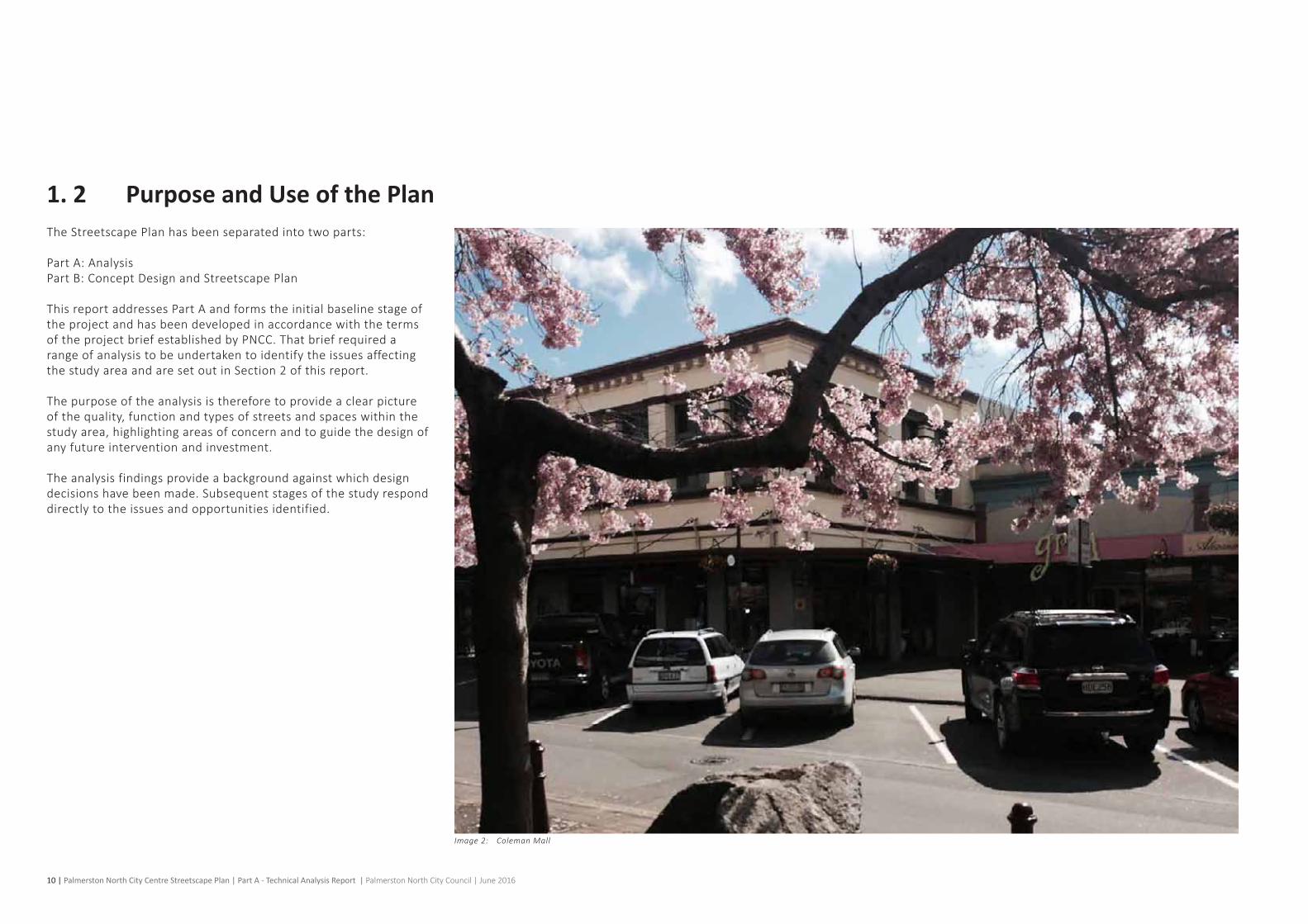
Image 2: Coleman Mall

Palmerston North City Centre Streetscape Plan | Part A - Technical Analysis Report | Palmerston North City Council | June 2016 | 11
5DESIGN TEAM WORKING
WO
RKSH
OP
1
STAGE ONE - ANALYSIS
1 PROJECT MOBILISATION & STAKEHOLDER IDENTIFICATION
3IPT & IRG WORKSHOP
2BACKGROUND REVIEW, ANALYSIS AND DESIGN OPTIONS SCOPING
OCTOBER 2015
4STAKEHOLDER ENGAGEMENT
WO
RKSH
OP
2
WO
RKSH
OP
3
5DESIGN TEAM WORKING
STAGE TWO - OUTLINE DESIGN
JANUARY 2016
WO
RKSH
OP
4
7STAKEHOLDER ENGAGEMENT
8PREFERRED DESIGN, TESTING & DEVELOPMENT
PN
CC P
RESE
NTA
TIO
N
1
PN
CC P
RESE
NTA
TIO
N
2
STAGE THREE - CONCEPT DESIGN & STREETSCAPE PLAN
APRIL 2016
PN
CC P
RESE
NTA
TIO
N
3
WO
RKSH
OP
5
JUNE 2016
9STREETSCAPE PLAN & MATERIALS PALETTE REPORT PREPARATION
10REFINE & FINALISE STREETSCAPE PLAN AND MATERIALS PALETTE
6IPT & IRG WORKSHOP
1. 3 Programme and Process of EngagementTheprojectprogrammeissetoutintheadjacentFigure1:Projectprogramme. This describes the three-stage process running from September 2015 to June 2016.
Collaboration and engagement is integral throughout the three-stageworkplanandincludesPNCC,stakeholderandcommunityengagement events. The distribution of engagement ensures that ideas are developed ‘in the round’ and fully grounded through local officer,stakeholderandcommunitybuy-in.
The findings of the engagement sessions held to date have been includedasAppendicestothisreport.These,andsubsequentengagementsessions,willsupportthedevelopmentoftheStreetscape Plan.
Acronymswithinthisdiagramare:• InternalProjectTeam(IPG);and• InternalReferenceGroup(IRG).
Figure 1: Project programme

12 | Palmerston North City Centre Streetscape Plan | Part A - Technical Analysis Report | Palmerston North City Council | June 2016
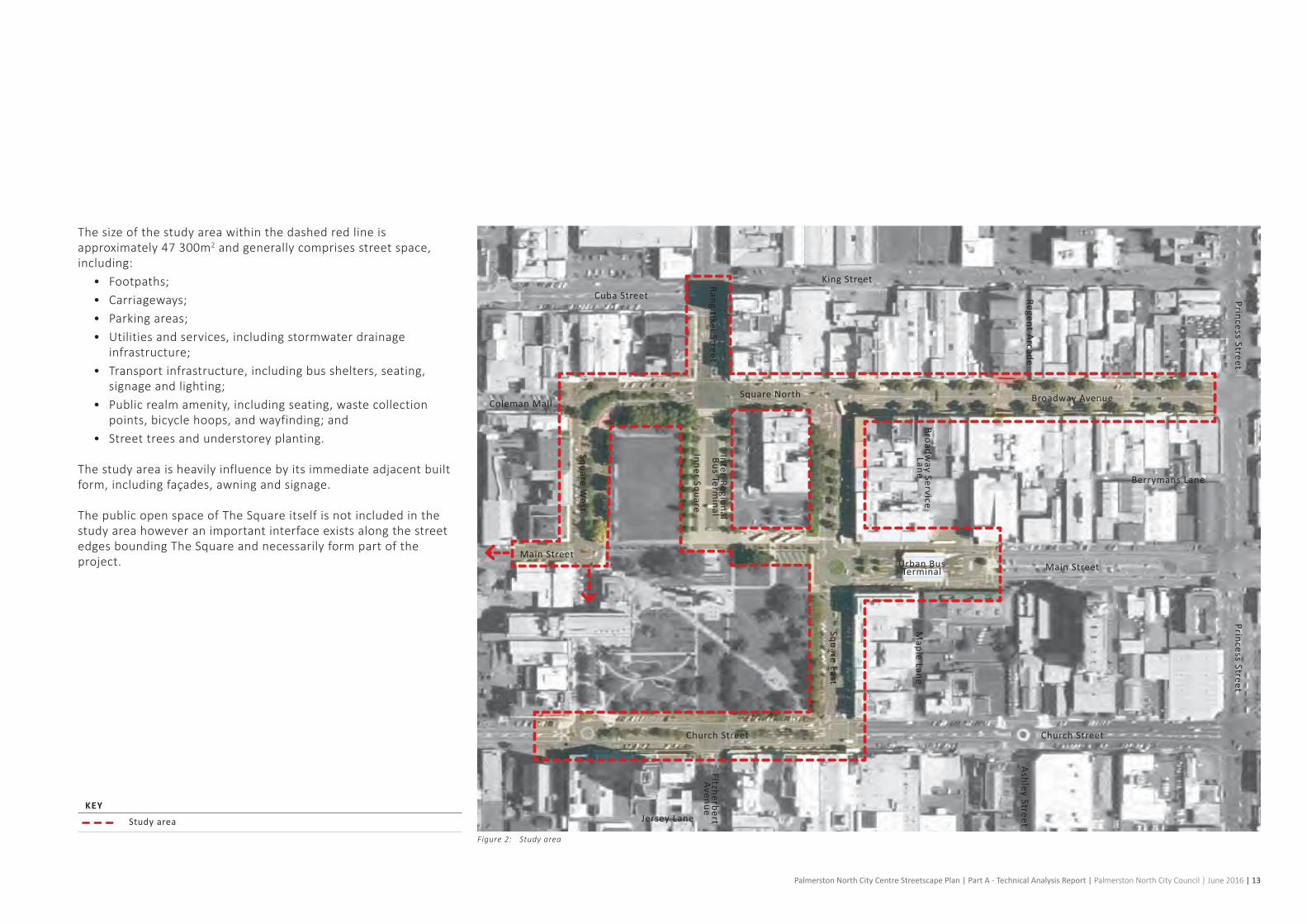
1. 4 Study AreaTheStreetscapePlancoversanareashownontheadjacentFigure2:Studyarea.TheStreetscapePlanisfocusedonthestreetswithinthePalmerstonNorthcitycentre,andiscomprisedof:
• RangitikeiStreetbetweenKingStreetandSquareNorth;• BroadwayAvenuebetweenSquareNorthandPrincessStreet;• Square North;• SquareWest,northofMainStreet;• SquareEast,betweenBroadwayAvenueandChurchStreet;• ColemanMall,attheinterfacewithTheSquare;and• ChurchStreetbetweenSquareEastandSquareWest.
ThestudyareahasbeenextendedfromtheoriginalPNCCRFPtoinclude:
• AsmallportionofMainStreet(west),asindicatedonFigure 2: Study area; and
• AcriticallinkfromtheInnerSquaretoSquareEast(atMainStreet intersection).
TheUrbanBusTerminallocatedonMainStreetandtheInter-RegionalBusTerminallocatedwithintheInnerSquareareincludedwithin the study area.
Image 3: Broadway Avenue
Palmerston North City Centre Streetscape Plan | Part A - Technical Analysis Report | Palmerston North City Council | June 2016 | 13
KEY
Study area
Broadway Avenue
Berrymans Lane
Maple Lane
Inter-Regional Bus Term
inal
Princess StreetPrincess Street
Square East
Regent Arcade
Broadway Service
Lane
Fitzherbert Avenue
Ashley Street
Square West
Church Street Church Street
Main Street
Jersey Lane
Main Street
Coleman Mall
Cuba Street
King StreetRangitikei Street
Inner Square
Urban Bus Terminal
Square North
The size of the study area within the dashed red line is approximately47300m2andgenerallycomprisesstreetspace,including:
• Footpaths;• Carriageways;• Parkingareas;• Utilitiesandservices,includingstormwaterdrainage
infrastructure;• Transportinfrastructure,includingbusshelters,seating,
signage and lighting;• Publicrealmamenity,includingseating,wastecollection
points,bicyclehoops,andwayfinding;and• Street trees and understorey planting.
Thestudyareaisheavilyinfluencebyitsimmediateadjacentbuiltform,includingfaçades,awningandsignage.
The public open space of The Square itself is not included in the studyareahoweveranimportantinterfaceexistsalongthestreetedges bounding The Square and necessarily form part of the project.
Figure 2: Study area

14 | Palmerston North City Centre Streetscape Plan | Part A - Technical Analysis Report | Palmerston North City Council | June 2016
1. 5 Approach to AnalysisTheStreetscapePlanadoptsthefollowingoverallapproachtoanalysisasshownontheadjacentFigure 3: Approach to analysis and discussedbelow.Fourcategoriesaredefinedwitharangeofdetailedanalysiswithineachcategory.Theseinclude:
A) Access and MovementThis category identifies the range of modes of movement across thestudyarea,includingtheprovisionofcarandcycleparking.Accommodatingappropriatelevelsofprivatevehicularaccess,servicingandparkingarekeyissuesaffectingthestreetswithinthestudy area.
Public transport provision is assessed including services at both the UrbanBusTerminalandtheInter-RegionalTerminal.
Alsoaddressedaretheissuessurroundingwayfinding,legibilityandsafety.
Fivesub-categoriesA1toA5areidentifiedthatmapthevariousmodesofmovement,includingthedistributionandutilisationofparkingandcycling,theprovisionofpublictransport(buses)andtheoverallpatternsofvehicular,pedestrianandcyclemovements.Alsoaddressedisthegeneralqualityofwayfindingacrossthearea,referringtoissuesoflegibilityand‘easeofuse’forusers.Finally,behaviouralmattersareanalysed,includingsafetyandsecurity,andgeneral patterns of use.
A1)On-streetparking: Privatevehicles Bicycle Motorcycle Loading zones
A2) Publictransport: Routesandinfrastructure
A3)Movement: Pedestrian Vehicular Cycling
A4)Wayfindingandprimarybuildingentrances
A5) Behaviouranduserexperience: CPTED
This part of the analysis has been supported by transport and traffic advice within PNCC.
B) Built FormThis category focuses on the physical built fabric within the study area.Theexistingbuildings(andtheirfaçades,awningsandsignage) are not included within the scope of the Streetscape Plan,howeverhavebeenincludedwithintheanalysisasthebuildings’design,detailing,setbackandusecangreatlyaffectthecommunity’s perception of the public realm and subsequent public realmexperience.
Fivesub-categoriesB1toB5areidentifiedthathighlightthescaleof the ‘built-to-open’ characteristics of the area along with a range ofqualitativeassessmentsofthebuildingedges:
B1) Figuregroundstudy
B2) Architecturalquality
B3) Buildingfrontageratings
B4) 3Dblockmodelling
B5) Heritagecategorybuildings
C) City Life and CultureThis category describes the activation of the public realm and in parallel with physical environmental factors is an important aspect toenhancingtheoverallquality,experienceandoccupationofPalmerston North’s streets and spaces.
Foursub-categoriesC1toC4areidentified:
C1) Buildinguse
C2) Streetoccupation: Cafés(outdoordining) Street vendors Retailspillout
C3)Streetart,publicartandevents
C4) Cultural precincts

Palmerston North City Centre Streetscape Plan | Part A - Technical Analysis Report | Palmerston North City Council | June 2016 | 15
D) ENVIRONMENT & SPATIAL QUALITY
A) BUILDINGS
B) ACCESS AND MOVEMENT
C) CITY LIFE AND CULTURE
A0) Study AreaA1) Figure Ground StudyA2) Architectural Quality A2) Building frontage ratings - i.e. Heritage & special buildings A3) 3D block modelling - heights, density of built formA4) Heritage Category Buildings
Appendices:1. Operative District Plan2. Proposed District Plan
B1) Parking & Cycling B2) Public Transport: Bus Routes B3) Movement (Pedestrian & Vehicular)B4) Way�nding & Primary Building EntrancesB5) Behaviour and user experience - CPTED - IPTED
D1) Linkages & Spatial Mapping - View-shafts - Landmarks & landforms D2) Public Realm Quality - Materials & furniture PaletteD3) Vegetation Distribution & Quality (including any protected landscape features) D4) Climate / Micro-climate - i.e sun/shade studies, prevailing wind, noise, warm and cool edgesD5) Services
C1) Building UseC2) Street Occupation - Cafés (outside dinning) - Street vendors - Retail C3) Street Art, Public Art & Events C4) Cultural Precincts
B) BUILT FORM
A) ACCESS AND MOVEMENT
C) CITY LIFE AND CULTURE
D) ENVIRONMENT AND SPATIAL QUALITY
A1) Parking and cycling A2) Public transport: bus routes
A3) Movement A4) Wayfinding and primary building entrances
A5) Behaviour and user experience
C1) Building use
C2) Street occupation
C3) Street art, public art and events C4) Cultural precincts
D1) Linkages and spatial mapping
D2) Public realm quality
D3) Vegetation distribution and quality D4) Climate / microclimate
D5) Services
D) ENVIRONMENT & SPATIAL QUALITY
A) BUILDINGS
B) ACCESS AND MOVEMENT
C) CITY LIFE AND CULTURE
A0) Study AreaA1) Figure Ground StudyA2) Architectural Quality A2) Building frontage ratings - i.e. Heritage & special buildings A3) 3D block modelling - heights, density of built formA4) Heritage Category Buildings
Appendices:1. Operative District Plan2. Proposed District Plan
B1) Parking & Cycling B2) Public Transport: Bus Routes B3) Movement (Pedestrian & Vehicular)B4) Way�nding & Primary Building EntrancesB5) Behaviour and user experience - CPTED - IPTED
D1) Linkages & Spatial Mapping - View-shafts - Landmarks & landforms D2) Public Realm Quality - Materials & furniture PaletteD3) Vegetation Distribution & Quality (including any protected landscape features) D4) Climate / Micro-climate - i.e sun/shade studies, prevailing wind, noise, warm and cool edgesD5) Services
C1) Building UseC2) Street Occupation - Cafés (outside dinning) - Street vendors - Retail C3) Street Art, Public Art & Events C4) Cultural Precincts
B0) Study area
B1) Figure ground study
B2) Architectural quality
B3) Building frontage ratings
B4) 3D block modelling
B5) Heritage category buildings
D) Environment and Spatial Quality
This final category analyses a wide range of physical environmental matters that effect the quality of streets and spaces and the users’ perceptions of them.
Thelegibilityofthestudyarea,keyviews,landscapeprovision,andpublic realm quality are all assessed.
Fivesub-categoriesD1toD5areidentified:
D1) Linkagesandspatialmapping: View-shafts Landmarksandlandforms
D2) Publicrealmquality: Materialsandfurniture palette
D3) Vegetationdistributionandquality
D4) Climate/microclimate: Sun/shade Wind Noise Warmth Cool edges
D5) Services
Figure 3: Approach to analysis

16 | Palmerston North City Centre Streetscape Plan | Part A - Technical Analysis Report | Palmerston North City Council | June 2016
Reference DocumentsInternational PublicationsCityofNewYork,2013,Active Design: Shaping the Sidewalk Experience
CityofNewYork,2013,Active Design: Shaping the Sidewalk Experience - Tools and Resources
CityofSydneyCouncil,2013,Sydney Streets Code
Gehl,J.,2010,Cities for People
National, Regional and Local PublicationsLandry,C.,June2013,Creative City Index: Comfortable or Captivating - An Assessment of Palmerston North
Historic Places in Palmerston North,2013,Availablefrom<http://www.historicmanawatuhorowhenua.org.nz/Downloads/Historic%20Places%20in%20PN%20Second%20Edition%202013.pdf>.[November 2015]
PalmerstonNorthCityCouncil,August2013,Street Design Manual For Palmerston North
PalmerstonNorthCityCouncil,August2013,City Centre Framework For Palmerston North
PalmerstonNorthCityCouncil,January2016,Draft Vegetation Framework For Palmerston North
Palmerston North District Plan,2000,Availablefrom<http://www.pncc.govt.nz/plans-policies-and-public-documents/plans/district-plan/>.[November2015]
Palmerston North Geo Guide,n.d.,Availablefrom<http://geoguide.pncc.govt.nz/>.[November2015]
Palmerston North Urban Services, 2014,Availablefrom<http://www.horizons.govt.nz/assets/getting-people-places-publications/PNTHbustimetableNOV2013WEB.pdf>.[November2015]
+engagementwithlocalstakeholdersandcommunitymembersasper the report.

Palmerston North City Centre Streetscape Plan | Part A - Technical Analysis Report | Palmerston North City Council | June 2016 | 17
STREET DESIGN MANUAL FOR PALMERSTON NORTHPALMERSTON NORTH CITY COUNCIL
Place Streets (Type 1)
Street Character
Destinationforpeopledayandnight.Character,humanscaleandhumanspeed.Pedestrianpriorityandresponsetotheurbancontexttakesclearprecedenceovervehicularmovement.Opportunitytoincreasepedestrianamenity through provision of more pedestrian priority space.
BuiltFormandActivation
Activeedges.Multiplebuildingdevelopmentopportunities.Finegrainbuiltformsuitableforarangeofactivities.
VehicularTypes,Activity,Volumesand Speed
Cycles,servicevehicles,emergencyvehicles,publictransportandprivatemotorvehicles.Largelydestinationoriented,lowvolumes,lowspeed.
VehicularAmenity
Generallysinglelanemovementineachdirection.Wholeofenvironmenttrafficcalming-Utilisecarefullyconsidereddesigninterventionstopromote‘psychological’trafficcalmingandencourageappropriatebehaviouralresponsesfromallusersofthestreet.Parkingandloadingcan be accommodated but does not dominate the street environment. Service / delivery vehicle and bus movements are carefully considered and accommodated if necessary. Use of space within the street may change overa24hourperiod-thesamespacemaybeusedforshorttermparkinganddeliveries,outdoordiningandeventsatdifferenttimesofthedayandnight.Trafficsignalphasingoptimisedtoprioritisepedestrianmovementovervehiclemovementatsignalisedintersections-adapttoAMandPMpeakmovementpatterns.
PedestrianAmenity Streetfurnitureandsoftlandscapingthatisofahigherstandardthanotherstreets.
Minimum Circulation Minimum 3.0 meter wide pedestrian footpath.
Street Infrastructure Streetfurnituresuchasbenches,cyclestandsandlightingispositionedwithinaclearlydefinedareabetweentrafficandfootpaths.
Way-findingandSignage
Streetsignageisconsolidated.Softlandscapingisnotlocatedonkeypedestrian desire lines.
CyclistAmenityCyclists share the street at a slow speed with pedestrians and vehicles. No designatedcyclelanesareprovided.Alllevelsofcyclingabilityfeelsafe.Cycleparkingissupplied.
Stormwater Management
Onsitestormwatermanagementtechniquese.g.rain-gardens,swalesandpermeable tree pits.
Street Trees InconjunctionwithCity-WideVegetationFramework.Largetreepitsareutilisedtoencourageandestablishgoodtreerootgrowth.
Lighting Pedestrianlevellighting(Pcategory)isachieved.Amenitystreetlightingmaybereinforcedbyfeaturelightingtoemphasise‘senseofplace.’
PublicArtandActivation Integrationofartworksintosite-specificstreetfurnitureorstructures.
Technical Junctionradii1-3m.Kerbsareeitherflushorroundedtoeasemovementsfor cyclists.
Place Streets (Type 2)
Street Character
Destinationforpeopledayandnight.Character,humanscaleandhumanspeed.Pedestrianpriorityandresponsetotheurbancontexttakesclearprecedenceovervehicularmovement.Opportunitytoincreasepedestrianamenity through provision of more pedestrian priority space.
BuiltFormandActivation
Activeedges.Multiplebuildingdevelopmentopportunities.Finegrainbuiltformsuitableforarangeofactivities.OutdoorTradingPoliciestoensureconsistentapproachtakentospatialprovisionofoutdoordiningareasanduseofappropriatelydesignedoutdoorfurniture.Significantareasofopenspaceconnectedtoadjacentbuildingsthroughstreetdesign.
VehicularTypes,Activity,Volumesand Speed
Cycles,servicevehicles,emergencyvehicles,publictransportandprivatemotorvehicles.Largelydestinationoriented,lowvolumes,lowspeed.
VehicularAmenity
Generallysinglelanemovementineachdirection.Wholeofenvironmenttrafficcalming-Utilisecarefullyconsidereddesigninterventionstopromote‘psychological’trafficcalmingandencourageappropriatebehaviouralresponsesfromallusersofthestreet.Parkingandloadingcan be accommodated but does not dominate the street environment. Service / delivery vehicle and bus movements are carefully considered and accommodatedifnecessary.Parkingbaysprovideflexiblespaceforshorttermparking,deliveries,eventsandplacemakingopportunities
PedestrianAmenityStreetsarepartofpublicrealmandconnectwithadjacentopenspace.Streetfurnitureandsoftlandscapingthatisofahigherstandardthanotherstreets.
Minimum Circulation
3.0m wide pedestrian footpath
Street Infrastructure
Consistent use of street furniture and other landscape elements between streetandadjacentopenspacetoprovidecomplementaryplacesforpublicenjoyment.Streetfurnituresuchasbenches,cyclestandsandlightingispositionedwithinaclearlydefinedareabetweentrafficandfootpaths.Maintenanceofstreetfurnitureandsoftlandscapingiscarefullyconsidered.
WayfindingandSignage
Streetsignageisconsolidated.Softlandscapingisnotlocatedonkeypedestrian desire lines
CyclistAmenityCyclists share the street at a slow speed with pedestrians and vehicles - no designatedcyclelanesareprovided.Alllevelsofcyclingabilityfeelsafe.Cycleparkingissupplied
Stormwater Management
Onsitestormwatermanagementtechniquese.g.rain-gardens,swalesandpermeable tree pits.
Street TreesInconjunctionwithCity-WideVegetationFramework.Largetreepitsareutilisedtoencourageandestablishgoodtreerootgrowth.
LightingPedestrianlevellighting(Pcategory)isachieved.Appropriatestreetlightingis integrated.
PublicArtandActivation
Technical Junctionradii1-3m.Kerbsareeitherflushorroundedtoeasemovementsfor cyclists.
Movement / Place Streets
Street Character
Combinationofdestinationsforpeopledayandnight,andkeymovementcorridorsacrossthecitycentre.Activeedgesandarangeofuses,themajorityofwhicharepedestrian-based(e.g.retail,offices,diningandentertainment).Keypassengertransportfunction.Highlevelofpedestrianprioritywhilstfacilitatingefficientvehicularmovement.
BuiltFormandActivation
VehicularTypes,Activity,Volumesand Speed
Cycles,servicevehicles,emergencyvehicles,publictransportandprivatemotor vehicles
VehicularAmenity
Generallysinglelanemovementineachdirection.Wholeofenvironment.Balanceuseof‘psychological’trafficcalmingtechniqueswithappropriateuseofconventionaltrafficcalmingmeasures,e.g.horizontalandverticaldeflection.Parkingandloadingcanbeaccommodatedbutdoesnotdominate the street environment. Service / delivery vehicle and bus movements are carefully considered and accommodated if necessary. Demarcatedparkingbaysmayprovideflexiblespaceforotherusesduringdifferenttimesofthedayandnight.Uncontrolledcrossingpointsareusedmid-blocktominimiseseveranceandmaximisepermeability.Privateaccesswaysacrosspublicspaceshouldbedesignedsothattheylookandfeelliketheyarepublicspaces(ratherthanapublicentrance).Vehicularcarriageway tends to be narrow and not dominant of the overall street character.
PedestrianAmenityStreetfurnitureandsoftlandscapingthatisofahigherstandardthanotherstreets.
Minimum Circulation
3.0mwidepedestrianfootpathnexttobuildingfrontages.3.0mwideoffroadsharedcycle/walkway.Allocateatleasthalfofthestreettopedestrians and cyclists.
Street Infrastructure
WayfindingandSignage
Streetandhighwaysignageisconsolidated.Softlandscapingisnotlocatedonkeypedestriandesirelines.
CyclistAmenity
Cyclists share the street at a slow speed with pedestrians and vehicles -designatedlanesmaybeprovideddependentuponspatialavailability.Alllevelsofcyclingabilityfeelsafe.Cycleparkingissupplied.Themajorityof carriageway space is allocated and designed for pedestrian / cyclist movement and human scale behaviour.
Stormwater Management
Street Trees InconjunctionwithCity-WideVegetationFramework.
LightingPedestrianlevellighting(Pcategory)isachieved.Appropriatestreetlightingis integrated
PublicArtandActivation
TechnicalJunctionradii1-3m.Dropkerbsarealignedwithkeycycleroutestoeasemovementforcyclists.Kerbalignmentsarerationalisedtosimplifyvehicularmovementwherepracticalandincreaselegibilityandeaseofuse.

18 | Palmerston North City Centre Streetscape Plan | Part A - Technical Analysis Report | Palmerston North City Council | June 2016

Palmerston North City Centre Streetscape Plan | Part A - Technical Analysis Report | Palmerston North City Council | June 2016 | 19
2. Technical Analysis

20 | Palmerston North City Centre Streetscape Plan | Part A - Technical Analysis Report | Palmerston North City Council | June 2016
Thereisaprevalenceofon-street,angledparking.Mostparkingwithinthestudyareaisamaximumof120minutes,paidparking.Asaresult,theon-streetparkingcompeteswiththefree60minuteparkingprovidedinThePlaza.
Parkingtypicallydiscourageslongstaysinthecitycentre.WiththeexceptionofDowntown’sfreeparkingonSundays,andreducedeveningcharges.AllCouncilcontrolledparkingisfreeonSaturdayafter3.30pmandalldaySunday,aswellasafter5.30pmonweekdays.
Severalofthecarparkingspacesaredesignateddisabledparking.This is unevenly distributed throughout the site. The Courthouse includesadisabledparkingspaceonsite,accessforwhichmustbeconsideredwiththeplanningoftheMainStreetUrbanBusTerminal.
Motorcycleparkingisprovidedwithinthestudyarea,predominantlyalongBroadwayAvenueandChurchStreet.Loadingzonesareprovidedalongmostblocks,with15minutetimelimitsallowing servicing to the various retail and commercial frontages.
Cyclistparkingisdistributedthroughoutthestudyarea,atintersections and along shopping routes. There appears to be sufficientcyclistparkingforthecyclemovementswithinthestudyarea,howevercommunityandstakeholderfeedbacksuggeststhat it is unsafe. More cycle infrastructure should be provided to encourage greater use of active transport.
Externaltothestudyarea,PNCChasincorporatedshortterm,unpaidparkingof15and30minutes.TheseparkingspacesareonSquareWestbetweenChurchandMainStreets.Therearealsoafewwithinthestudyarea,onMainStreetoutsidethePostShop.
Constraints• Palmerston North is a sprawling city that is reliant upon
vehicular movement and access. There are competing demandsbetweenvehicularandpedestrianamenity,howevera balance must be achieved to ensure the streetscape allows adequateparkingandmanagementtosupporteconomicsustainability and growth.
• The Streetscape Plan must be designed with consideration for theCouncil’sParkingManagementPlan.
Opportunities• Reviewdistributionofparkingandparkingtypesforpublic
transport,privatevehicles,motorcyclists,cyclistsandpedestrians to encourage new movement throughout the city centree.g.freeparking,variedtimedallowances.
• Reviewcycleinfrastructuretoencouragegreateruseofactivetransport.
2. 1 Access and Movement - On-Street Parking
Image 4: Square East

Palmerston North City Centre Streetscape Plan | Part A - Technical Analysis Report | Palmerston North City Council | June 2016 | 21
KEY
Parallel parking
Perpendicular parking
Angle parking
Loading zone
Motorcycle parking
Disabled parking
POff-Street car parking
Bicycle parking
Taxi stand
P P
PP P
P
P
Square East114 spaces including: 3 disabled spaces1 loading zone2 motorcycle parking areas
Church Street140 spacesincluding: 2 disabled spaces3 loading zones2 motorcycle parking areas
Broadway Avenue131 spaces including: 5 disabled spaces8 loading zones3 motorcycle parking areas
Coleman Mall17 spaces including: 1 disabled space
Square North62 spaces including: 2 disabled spaces2 loading zone1 motorcycle parking area
Rangitikei Street7 spaces including: 2 loading zones
Square West (north section) 53 spaces including: 1 disabled space1 loading zone
Square West (south section) 27 spaces including: 1 disabled space2 loading zones
Main Street East155 spaces including: 4 disabled spaces2 loading zones6 motorcycle parking areas
Main Street West9 spaces including: 1 loading zone1 motorcycle parking area
Figure 4: On-street parking
Broadway Avenue
Berrymans Lane
Maple Lane
Inner Square
Princess Street
Square East
Regent Arcade
Broadway Service Lane
Fitzherbert Avenue
Ashley Street
Square West
Church Street
Main Street EastMain Street West
Coleman Mall
Cuba Street
King Street
Rangitikei Street
Square North
Courthouse
Downtown
UCOL
The Plaza
PNCC
The Regent
on Broadway
Library
High Flyersi.Site
Church Street

22 | Palmerston North City Centre Streetscape Plan | Part A - Technical Analysis Report | Palmerston North City Council | June 2016
2. 2 Access and Movement - Public Transport - Bus RoutesThere are 22 bus routes regularly servicing the study area. The Square,ChurchStreet,FitzherbertAvenue,MainStreetandRangitikeiStreetsupportbusmovementsfromtheUrbanandInter-RegionalBusTerminals.
Bothterminalsincludeholding/parkingareasandassociatedinfrastructure(shelter,lighting).
BusesareanintegralpartoftheurbanlifeofPalmerstonNorth,seen as a public service. The services run throughout the day and intotheearlyevening,typicallybetween6-7amand6-7pm.SomeadditionalservicesrunonFridayevenings.Theservicesrunto/fromthesuburbs,andstart/terminateattheMainStreetUrbanBusTerminal.
Significant pedestrian traffic is created where there are bus stops. AstheUrbanBusTerminalisthestartingpointforanumberofroutes,therearegenerallypeoplewaitingmosttimesduringtheday in and around the terminal. It is important that any waiting area feels comfortable and safe for all bus patrons.
Busterminalsrequirehardwearingmaterialsandsurfacestosupportheavy,dailyusebyarangeofpeople.Thisoftencreatesaneedtoworkwithalimitedsetofmaterialstominimisedamageboth by operational and human activity. The terminal also needs to beeasilycleanedandmaintained.Tothatend,itisimportantthatthe material selection and detailing are designed to a human scale andcomfortlevel,evenifthematerialsarerobustandutilitarian.The end result should create a positive anchor for the urban designofthecitycentre,anattractiveandsafepublicspacethatdiscourages antisocial behaviour.
ConstraintsServices can be re-routed to minimise movements through the sensitiveinnerarea.However,thiswillhaveanassociatedincreaseinvehiclekm’swhichinturnwillhaveincreasedcostsoverandabove those contracted.
Opportunities• ReviewbusmovementsbetweenRangitikeiStreetandMain
Street to ensure prioritisation of pedestrians and active transport choices.
• There is some scope to relocate bus and coach layovers (down time between arrivals and departures) to a location where space is not at such a premium. This does introduce additional movements.
• Rationalisespacededicatedtotheurbanterminaltoallowfora higher level of pedestrian activity.
• Reviewthematerialsandsurfacesforbusterminalstoconsider human scale and comfort as well as operational maintenance. The end result should create a positive anchor fortheurbandesignofthecitycentre,anattractiveandsafepublic space that discourages antisocial behaviour.
Image 5: Main Street - Urban Bus Terminal

Palmerston North City Centre Streetscape Plan | Part A - Technical Analysis Report | Palmerston North City Council | June 2016 | 23
KEY
Urban Bus Terminal
Bus stop
Inter-Regional Bus Terminal
Inter-regional bus route
Bus routes (as per Horizon Regional Council website)
PALMERSTON NORTH GOLF CLUB
MANAWATU GOLF CLUB
AM
BER
LEY
AVE
HAVELOCK AVE
HIGHBURY
AVE
FERGUSON ST
RUGBY ST
CHURCH ST
SLACKS RD
MANAWATU ST
MANSON ST
LIMBRICK ST
FERGUSON ST
BR
IGH
TWAT
ER
TCE
RHODES DR
HILLCREST DR
FERNLEA AVE
BROOKLYN HEIGHTS DR
"HA
IL"
IHAKA ST
JICKELL ST
BROADWAY AVE
LOM
BA
RD
ST
FAIRS RD
RENN
IE A
VE
HE
RE
TAU
NG
A S
T
TREMAINE AVE
PARKLAND CRES
FITZ
RO
Y ST
FEATHERSTON ST
SCH
NE
LL
DR
CHATSWORTH ST
ONGLEY PARK
AWAPUNI PARKALEXANDER
PARK
THESQUARE
CENTENNIAL
DR
PEMBROOKE STCLARKE AVE
HIG
HB
URY AVE
WES
T S
T
FAIRS RD
LONG MELFORD RD
BO
UR
KE
ST
RU
SSE
LL S
T
MO
NR
AD
ST
FEATHERSTON ST FEATHERSTON ST
BENNETT ST
VICT
ORI
A AV
E
AM
BE
RLE
Y AV
E
FERGUSON ST
FITZ
HE
RB
ERT
AVE
RA
NG
ITIK
EI S
T
RU
AH
INE
ST
WA
RD
ST
BRY
AN
T ST
MO
RR
IS S
T
PARNELL HEIGHTS
RANGIORA AVE
Havelock Shops
COLLEGE ST COLLEGE ST
PITA
MA
RD
MA
XW
ELL
S L
INE
BO
TAN
ICA
L R
DB
OTA
NIC
AL
RD
CO
OK
ST
TREMAINE AVE TREMAINE AVE TREMAINE AVE
BENMORE AVE
GIL
LESP
IES
LIN
E
RA
NG
ITIK
EI S
T
JOHN F KENNEDY DR
AIRPORT DR
KELVIN GROVE RD
RU
AH
INE
ST
GREY STNG
ATA
ST
MAIN ST MAIN ST
MCLEAVEY DR
KA
IMA
NAW
A S
T
RO
BE
RTS
LIN
ER
OB
ER
TS L
INE
MIHAERE D
R
NAPIER RD NAPIER RD
RUAHINE ST
COLLEGE ST
PAHIATUA ST
FITZ
HE
RB
ERT
AVE
TE AWE AWE ST
SUM
ME
RH
ILL
DR
RU
AP
EH
U D
R
PAH
IATU
A A
OK
AU
TER
E R
D
Te KuraKaupapaMaori OMana
Tamariki
ROSSINTERMEDIATE
MONRADINTERMEDIATE
P. NO
RTH
IN
TER
MED
IATEN
OR
MA
L SC
HO
OL
PIONEER HWY MAIN ST
Julia Wallace
Retirement Village
Metlife CareRetirement
Village
PN PUBLIC HOSPITAL
OLIVE TREE Retirement
Village
BILL BROWN PARK
CORONATION PARK
MEMORIAL PARK
COLQUHOUN PARK
MONRAD PARK
CELAENO PARK
VICTORIA ESPLANADE
VAUTIER PARK
UCOL
Arena Manawatu
Railway Station
Lido Aquatic Centre
Kelvin Grove Cemetery
Palmerston North
Airport
AWATAPU COLLEGE
FREYBERG HIGH SCHOOL
PN BOYS HIGH SCHOOL
QUEEN ELIZABETH COLLEGE
ST PETER'S
CO
LLEGE
PN GIRLS HIGH
SCHOOL
Te Kura Kaupapa Maori O Manawatu
Milson Shops
Roslyn Shops
Pitama Shops
Takaro Shops
Highbury Shops
Albert St Shops
Cloverlea Shops
Terrace End Shopping centre
OT
OT
OT
OT
OT
OT
OT
OT
OT
WORCESTER ST
WYNDHAM ST
ASHHURST SCHOOL
ASHHURST DOMAINNAPIER RD
OXF
ORD
ST
SALI
SBU
RY
ST
CA
MB
RID
GE
AV
E
YORK ST
MULGRAVE ST
CAM
BRID
GE
AVE
ASHHURST
TO ASHHURST
A1_stops_diag
Outer Terminal
Main St Terminal
Ashhurst
1 Awapuni
2 Rugby
3 Highbury
4 Takaro
5 Cloverlea
6 Milson
7 Rhodes
8 Roslyn
9 Rangiora
10 Brightwater
31 Fernlea
32 Heights
From Fldg
To Fldg
12 Massey
12A Massey
12B Massey
12C Massey
14 IPC
15 HC
MASSEY
IPC
Man
awat
uTr
ottin
g C
lub
Awapuni
Race
Course
LIVERPOOL ST
SED
DO
N S
T
CHELWOOD STRONBERG ST
PENCARROW ST
OT
HOLDSWORTH
AVE
ASP
IRIN
G
AVE
LAN
GLE
Y AV
E
KOROMIKO AVE
LYN
DH
UR
ST S
T
WALDING ST
RO
Y ST
NO
RTH
ST
TUR
ITEA
RD
CLYDECRES
To F
eild
ing
PARK RD
TENNENT DR
TENNENT DR
CUBA ST
MIL
SON
LIN
E
RAIL
WAY
RD
RAIL
WAY
RD
PRIN
CES
S ST
VOG
EL S
TVO
GEL
ST
JAM
ES L
INE
KEI
TH S
TK
EITH
ST
ALB
ERT
STA
LBER
T ST
AOKAUTERE DR
OLD WEST RD
Map Production Palmerston North City Council
September 2012
COLL
EGE
OF
EDUC
ATIO
N
Te WanangaO Aotearoa
Sports & Rugby
Institute
Manawatu CommunityAthletics
Track
Summ
erset
Retirem
ent Village
ALBANY DR
GRAB-A-GoCard! GoCard and Monthly Pass are prepaidtravel cards that entitle you to cheaper fares. Pick up one from your driver today!
For individual route maps, bus stop locations, questions and comments, check out www.horizons.govt.nz
or call freephone 0508 800 800. For Feilding services please see separate timetable.
PROVIDING THESE SERVICES FOR YOU
FARE INFORMATION
HOW TO USE THIS BUS TIMETABLE FAQS
Horizons Regional Council plans and helps fund affordable public transport within the Manawatu-Wanganui Region. UCOL and Massey University also provide funding to allow their students and staff to enjoy free travel within Palmerston North.
PUBLIC HOLIDAY?No bus services operate on
Good Friday, Easter Sunday,
Christmas Day or ANZAC Day.
On all other public holidays,
services operate according to
the Sunday timetable.
WHAT IS A GoCard OR MONTHLY PASS? GoCard and Monthly Pass are pre-paid travel cards that entitle you to cheaper travel and save you from worrying about having the correct change.
HOW TO USE THE URBAN SERVICESChoose the time you wish to travel and please be at the stop at least 5 minutes before the bus is scheduled to arrive.
Board the bus, place your GoCard on the electronic reader or pay your cash fare, and tell the driver your destination.
Remember to take your ticket with you.
Push the bell as you approach your stop.
USING YOUR TIMETABLEThe example below shows the timetable for those catching the bus on the No. 1 route (Awapuni) or No. 2 route (Rugby) to the Main St Terminal.
What does HOME ONLY mean?The driver won’t be picking up passengers on the route, only dropping off. The service departs the Main St Terminal and drops passengers off at the stop nearest their destination. Please note these routes may take longer than 40 minutes. What is an Outer Terminal?The Outer Terminal (OT) is a normal bus stop at the halfway point of the bus route.
The OT departure time should make it easier to estimate the time the bus will arrive at your stop.
Help! I’ve left something on the bus, who do I contact?Call Tranzit on (06) 355 4955. Please note no responsibility will be accepted by Tranzit or Horizons Regional Council for lost property.
More FAQs overleaf
Bus stops are shown on route maps as white dots.Buses take approximately 35-40 minutes to complete each loop from and back to the Main St Terminal.When the bus reaches the Outer Terminal (the point where it begins its return journey to the Main St Terminal) it may pause briefly to make sure the service is not running ahead of schedule.
Horizons Regional Council plans and operates services according to the timetable – but road conditions, traffic calming measures, special events and weather may cause delays.
A Monthly Pass allows you one month’s unlimited travel from first use. Simply pass your card within 5 centimetres of the electronic reader on the bus and you are ready to go. Pick up your GoCard or Monthly Pass from the driver.
HOW MUCH DO THEY COST?Your initial GoCard will cost $12, with $5 of travel already loaded. Initial Adult Monthly Pass costs $62; monthly top up $55. Initial Child Monthly Pass costs $42; monthly top up $35.All new/replacement cards have a one-off $7 administration fee.
You can top up your GoCard and Monthly Pass balances on the bus with cash or at the Tranzit office with EFTPOS (minimum GoCard top-up $10). Please keep your receipt and check the amount loaded is correct. Horizons Regional Council and Tranzit take no responsibility for damaged or lost cards and credit balances can not be transferred.
ONE HOUR FREE TRANSFER Purchase any single one-way ticket on any Palmerston North city bus and get one free transfer onto another city service within one hour of the original ticket purchase time. Not to be used for return journeys.
Remember to hold onto your ticket to redeem your free transfer and tell the driver as you board which bus you will be transferring to.
* On production of current ID or Community Services Card. Student fare available only with NZ tertiary education providers.
Cash Fare GoCard Fare
Child/Youth School-aged (If not in school uniform please provide ID) Under 5’s travel FREE
$1.50 $1.20
Concessions* Student, Beneficiaries, Senior 65+ $1.80 $1.50
Adult $2.50 $2.00
SuperGold Card Holders FREE FREE
Between 9am-3pm weekdays, all day on weekends and public holidays
UCOL / Massey Students & Staff * FREE FREE
Adult Monthly Pass (initial purchase) $62
Adult Monthly Pass top-up $55
Child Monthly Pass (initial purchase) $42
Child Monthly Pass top-up $35
Depart MST Route to OT Depart OT Route to MST Arrive MST
Mon- Fri
6.40 1 6.55 2 7.15
Time bus leaves the
Main St Terminal
Colour coded number
shows the route the
bus follows to Outer Terminal
Time bus leaves Outer
Terminal
Colour coded number shows
the route the bus follows to
Main St Terminal
Time bus arrives at
Main St Terminal
?
?
?
Fares subject to change. Please visit www.horizons.govt.nz
for up-to-date fare information.
Intercity Naked bus
Figure 5: Bus routes
Broadway Avenue
Berrymans Lane
Maple Lane
Inner Square
Princess Street
Square East
Regent Arcade
Broadway Service Lane
Fitzherbert Avenue
Ashley Street
Square West
Church Street
Main Street EastMain Street West
Coleman Mall
Cuba Street
King Street
Rangitikei Street
Square North
Courthouse
Downtown
UCOL
The Plaza
PNCC
The Regent
on Broadway
Library
High Flyersi.Site
Church Street

24 | Palmerston North City Centre Streetscape Plan | Part A - Technical Analysis Report | Palmerston North City Council | June 2016
2. 3 Access and Movement - Public Transport - FacilitiesSite Observations
• TheUrbanBusTerminalisanindustrialstylestructurethatinvokesautilitarianenvironment;
• Safetyconcernsaboutpedestrianswalkingacrossbuslaneshas introduced barrier fencing not conducive to pedestrians;
• Adarkenvironmentthatdoesnotenhancetheuserexperience;
• CentrallocationintheroadblocksviewsoftheRuahineRangesfromTheSquare;
• Fourlaneplatformsmakethespacefeelcongested;• Pedestrian space around the structure is heavily car
dominated;• TheCourthouse’srelationshipwithroad/UrbanBusTerminal
ispoorwithblankwalls,asmallsteppedentrancenotallowing any natural activity at its edges;
• Theadjacentcarparkcreatesa‘backofhouse’feeling;• Scale of the structure appears larger than is necessary;• Lighting is utilitarian and should be more friendly at night;• Waitingspacesfeelunfriendly/unsafeandcold/windy;• MainStreetEastfeelslikealeftoverspace-itiscar
dominated,withthebusterminalpositionedinthemiddle;• ThereisalackofconnectionbetweenTheSquareandMain
StreetEast,aswellasfromonesideofMainStreettothenext.ThispoorphysicalconnectionisexacerbatedbytheUrbanBusTerminalblockingvisualconnections;and
• Thetwoterminalshavelittlearchitecturalrelationship,despitebeingincloseproximitytoeachother.
ThepartofthestreetboundedbyHighFlyers/theoldlibrary,theCourthouseandthecarparkhassomeunfortunateurbanissuesincluding:
• Gapsinthestreet;• Lackofactiveedgesandlargeblankwalls;• Floorlevelsnotatgrade;• Carparkingatgroundlevel;
• Industrial structures that do not encourage human interaction;
• Industrial lighting;• Uncoordinatedmixoflandscapetreatments;and• AdditionstotheHighFlyersbuildingthatblocktheviewsand
movementsofpedestriansbetweenSquareEasttoBroadwayAvenue.
ContextPrivate investment to improve frontages and on-street activity is notlikelywithoutarevitalisedstreetscape.
LocationThecurrentUrbanBusTerminallocationissuccessful,howeverithas become the centrepiece of a low quality of streetscape. The busstationitselfisunfriendly,utilitarianandindustriallyscaled,formingasignificantblockageforconnectionsthroughandaroundthisarea.Thebuses,oncestopped,formalargewallwhichrestrictsviewlinesthroughthepublicdomain,creatingsafetyconcerns.Theconcrete barriers restrict vision across the street and the building castsagreatshedlikeshadowoverthesurroundingstreetscape.
Streetscape InterfaceMainStreethistoricallysupportedthecity’straininfrastructure,withthemaintrunklinerunningdownitscentre.Asaresult,itiswide enough to support a building site within the road reserve and still function as a through road for vehicles.
ThebuildingsinandaroundtheterminalincludetheCourthouse,theoldpostoffice/HighFlyers,andthecarpark.Thesehavebeenbuilt at various times and sit as independent buildings within thestreetscape.Allhavearelationshiptothestreetasaresultof floor level changes or road crossings. Investment to improve thesefrontagesisunlikelyunlessabenefitcanbeprovidedwitharevitalised streetscape.

Palmerston North City Centre Streetscape Plan | Part A - Technical Analysis Report | Palmerston North City Council | June 2016 | 25
KEY
Regional bus route
Visitor parking
i.Site
Courthouse
High Flyers
old library
at-grade carpark
Downtown
Urban Bus TerminalMain Street
Square EastSquare East
Figure 6: Urban Bus Terminal and bus routes
Image 6: Urban Bus Terminal

26 | Palmerston North City Centre Streetscape Plan | Part A - Technical Analysis Report | Palmerston North City Council | June 2016
The Square InterfaceTherearetwobusterminals,theUrbanandInter-RegionalBusTerminals.Presently,thetwoarelocatedwithinwalkingdistance,withtheInter-RegionalBusTerminallocatedwithintheInnerSquare.ThestructureoftheInter-RegionalBusTerminalhasbeendesignedasalightweightstructurewithaglazedroof,andintegratedwithexistingconcreteretainingwalls.Theterminalisorientedtowardthecarpark.Theterminalwasdesignedasatemporaryfacility,howeverisrecommendedtobepermanent.Shouldtheterminalremaininthislocation,improvementscouldinclude coordinated signage and a higher quality of detailing. Ambientlightingmustbeincludedtoensuresafeafterhoursuse.
Constraints• Operationalrequirementsofinter-regionalbusnetwork.• InterfacesensitivitieswithTheSquare(landscape,amenity,
views,heritage).• Vehicularaccessandpubliccarparkinginparallelwithbus
access.• Needtoworkwith/modifytheexistingcanopystructure;• HardertomovetheIntercityterminalbecauseofcurrent
infrastructure already built in;• Exposuretotheweather,particularlyinwinter;
Opportunities• Simplify vehicular movements and establish safe pedestrian
crossing points along Main Street and The Square.
Image 7: Inter-regional Terminal

Palmerston North City Centre Streetscape Plan | Part A - Technical Analysis Report | Palmerston North City Council | June 2016 | 27
KEY
Inter-regional bus route
Visitor parking
1
2
3
4
5 6 87
Toilets
Wellington Bound
Wellington Arrival
Napier Bound
Napier Arrival
i.Site
9 10
Main Street
Urban Bus Terminal
High Flyers
Broadway Avenue
Sqaure East
old library
Inter-Regional Bus Terminal
Square North
Figure 7: Inter-Regional Bus Terminal and bus routes

28 | Palmerston North City Centre Streetscape Plan | Part A - Technical Analysis Report | Palmerston North City Council | June 2016
Image 8: Church Street
2. 4 Access and Movement - VehicularThestudyareacomprisespartofamuchlargeropengridsystem,with a high level of route choice for vehicles. Management of movements is therefore difficult and past observations have demonstrated a high proportion of traffic entering the study area (centralCBD)passingstraightthrough.Trafficvolumesinthestudyarea are therefore higher than necessary to service the activities contained within and around it.
Alloftheroadswithinthestudyareaareidentifiedas‘PlaceStreets’intheCityCentreFramework,withtheexceptionofpartofMainStreet,whichtotheeastoftheUrbanBusTerminalisa‘Movement/Place Street’. These streets should therefore provide accesstoactivities,withahighlevelofaccessibilityandprioritygiventopedestrians,ratherthanaccommodatingthethroughvehicular movements which currently occur.
TheCouncilhascreateda30km/hrcitycentrezoneforstreetsthatarewithintheinner‘RingRoad’(ofwhichthestudyareaisapart),creatingasaferenvironmentforpedestriansandmotoristsalike.Italsodiscouragesthroughmovement,helpingtodefinethecitycentre as a destination.
Thehighlevelsofon-streetparkingthroughoutthestudyareaandshortblocklengthsresultinalowaveragevehiclespeed,withaveragespeedsforeachsectionbetween22kphto32kph.There is a clear focus on facilitating vehicular movement in and aroundthecitycentre,withwidetrafficlanesandparkingoneverycityblock.
Trafficlanesareprovidedinconsistently.Allstreets,withColemanMallandtheInnerSquaretheexceptions,haveatleastasinglelaneoftrafficineitherdirection.Additionalvehicularlanesallowforseparateturnlanesatmajorintersections,howeverindoingsoprioritise the vehicular movements over usable public domain.
Main Street’s vehicular configuration accommodates a variety of busturningmovements,whichresultsinanindustriallyscaledpublicrealmwithlargeexpansesofasphaltandlittlepedestrianamenity.
Constraints• ThesizeofTheSquarecanaddsignificantwalktimesfor
thosewithreducedmobilityunlessparkingisprovidedonallsectionsoftheperimeter,effectivelyreducingthewalkabilityoftheCBD.Vehicularaccessmustthereforeberetainedtoalllocations;
• The open nature of the grid means that route prediction and therefore management of traffic can be difficult.
• Busoperationalrequirementsrequirethetransferofvehiclesfromoneservicetoanother,androutingrequiresfurthermanoeuvres within the immediate terminal area. Some of the manoeuvring space is duplicated at the moment and could be optimised.
Opportunities• EstablishastreethierarchywhichbuildsonPNCC’sStreet
Typestodefinecharacter,purposeandkeycomponentsofeach city centre street;
• Thegridsystemprovidesin-builtresiliencetothenetworkandtoacertainextentprovidesadequatechoicefortrafficto‘self-regulate’,reducingtheoccurrenceofsignificantcongestion;
• The high level of accessibility and vehicular permeability providesopportunitiesforsomelinkstoberestrictedwhilemaintaining access to all locations;
• Theringroadoperateswellbelowcapacity,withefficiencygains possible with increased use (i.e. programming signals to favour the ring road over side roads; enabling ‘green waves’ to improvetraveltimesandjourneyreliability).
• Reviewvehicularmovementsandinfrastructureinlinewithaproposedstreethierarchy,increasingconnectivityand ensuring clear and logical wayfinding for vehicles and pedestriansalike.

Palmerston North City Centre Streetscape Plan | Part A - Technical Analysis Report | Palmerston North City Council | June 2016 | 29
Fitzherbert Avenue
Pitt Street
Pitt Street
The Square
Church StreetChurch Street
Main Street
Walding Street
Princess Street
Main Street
Ferguson Street
Rangitikei Street
KEY
Key vehicular movement
< 6 000 average daily movements
6 000 - 7 999 average daily movements
8 000 - 10 000 average daily movements
> 10 000 average daily movements
8 600
9 700
6 300
8 000
10 0007 5006 300
8 50012 00011 5008 600
7 000
8 000
The Square
11 0008 500
8 6005 000
5 000 4 6006 300
12 100 13 300Figure 8: Vehicular movement
30 | Palmerston North City Centre Streetscape Plan | Part A - Technical Analysis Report | Palmerston North City Council | June 2016
Image 9: Square East Image 10: Broadway Avenue
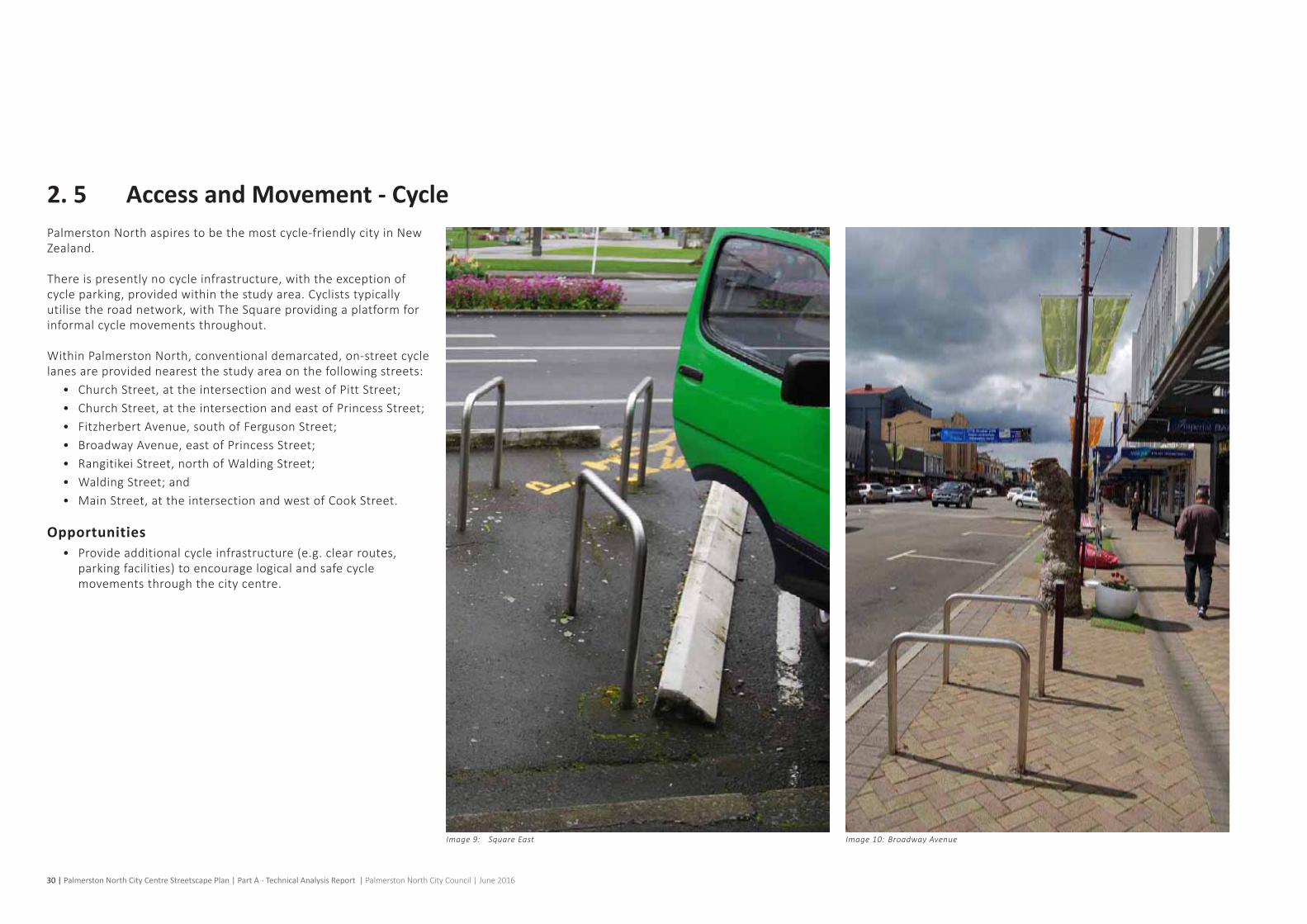
2. 5 Access and Movement - CyclePalmerston North aspires to be the most cycle-friendly city in New Zealand.
Thereispresentlynocycleinfrastructure,withtheexceptionofcycleparking,providedwithinthestudyarea.Cycliststypicallyutilisetheroadnetwork,withTheSquareprovidingaplatformforinformal cycle movements throughout.
WithinPalmerstonNorth,conventionaldemarcated,on-streetcyclelanesareprovidednearestthestudyareaonthefollowingstreets:
• ChurchStreet,attheintersectionandwestofPittStreet;• ChurchStreet,attheintersectionandeastofPrincessStreet;• FitzherbertAvenue,southofFergusonStreet;• BroadwayAvenue,eastofPrincessStreet;• RangitikeiStreet,northofWaldingStreet;• WaldingStreet;and• MainStreet,attheintersectionandwestofCookStreet.
Opportunities• Provideadditionalcycleinfrastructure(e.g.clearroutes,
parkingfacilities)toencouragelogicalandsafecyclemovements through the city centre.

Palmerston North City Centre Streetscape Plan | Part A - Technical Analysis Report | Palmerston North City Council | June 2016 | 31
KEY
Cycle movement
Informal cycle movement
Figure 10: Cycle movement
Broadway Avenue
Berrymans Lane
Maple Lane
Inner Square
Princess Street
Square East
Regent Arcade
Broadway Service Lane
Fitzherbert Avenue
Ashley Street
Square West
Church Street
Main Street EastMain Street West
Coleman Mall
Cuba Street
King Street
Rangitikei Street
Square North
Courthouse
Downtown
UCOL
The Plaza
PNCC
The Regent
on Broadway
Library
High Flyersi.Site
Church Street
32 | Palmerston North City Centre Streetscape Plan | Part A - Technical Analysis Report | Palmerston North City Council | June 2016
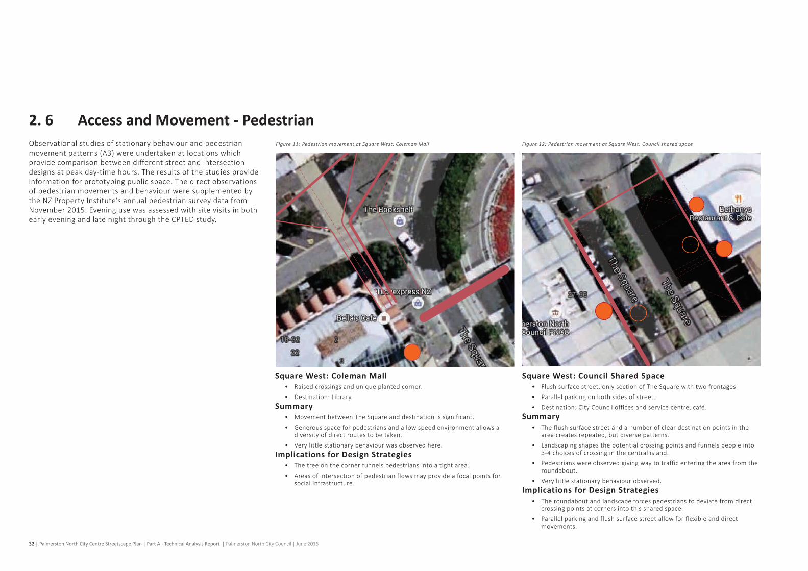
Square West: Coleman Mall• Raisedcrossingsanduniqueplantedcorner.• Destination:Library.
Summary• Movement between The Square and destination is significant. • Generousspaceforpedestriansandalowspeedenvironmentallowsa
diversityofdirectroutestobetaken.• Verylittlestationarybehaviourwasobservedhere.
Implications for Design Strategies• The tree on the corner funnels pedestrians into a tight area. • Areasofintersectionofpedestrianflowsmayprovideafocalpointsfor
social infrastructure.
Square West: Council Shared Space• Flushsurfacestreet,onlysectionofTheSquarewithtwofrontages.• Parallelparkingonbothsidesofstreet.• Destination:CityCouncilofficesandservicecentre,café.
Summary• The flush surface street and a number of clear destination points in the
areacreatesrepeated,butdiversepatterns.• Landscaping shapes the potential crossing points and funnels people into
3-4 choices of crossing in the central island. • Pedestrians were observed giving way to traffic entering the area from the
roundabout. • Verylittlestationarybehaviourobserved.
Implications for Design Strategies• The roundabout and landscape forces pedestrians to deviate from direct
crossing points at corners into this shared space. • Parallelparkingandflushsurfacestreetallowforflexibleanddirect
movements.
2. 6 Access and Movement - PedestrianObservationalstudiesofstationarybehaviourandpedestrianmovementpatterns(A3)wereundertakenatlocationswhichprovide comparison between different street and intersection designsatpeakday-timehours.Theresultsofthestudiesprovideinformation for prototyping public space. The direct observations of pedestrian movements and behaviour were supplemented by the NZ Property Institute’s annual pedestrian survey data from November2015.EveningusewasassessedwithsitevisitsinbothearlyeveningandlatenightthroughtheCPTEDstudy.
Figure 11: Pedestrian movement at Square West: Coleman Mall Figure 12: Pedestrian movement at Square West: Council shared space

Palmerston North City Centre Streetscape Plan | Part A - Technical Analysis Report | Palmerston North City Council | June 2016 | 33
KEY
100 pedestrian movements
< 10 pedestrian movements
Destination
Food trucks
NOTE
The samples include minor sources of error due to technology limitations and environmental factors which do not affect establishment of overall movements patterns. Sources of error: video footage, reflections in shop windows, shadows, large vehicles passing between camera location and pedestrian routes.
Square West / Church Street: Corner• Roundaboutwithraisedpedestrianplatforms.• Destination:SquareEdgeCreativeCentre.
Summary• TheedgesofTheSquarearethemostheavilyused,raisedcrossingsallow
people to move freely around the edge of the space. • No observed direct routes across the roundabout. People were observed
cuttingthecornerofTheSquareontheparkside.• Thedimensionsoftheroundaboutandraisedcrossingsmakepeoplewalk
further than necessary.Implications for Design Strategies
• The corners of The Square could be chamfered at entry points to facilitate cutting corners and entry. Size of intersections could be minimised to reducethewalkingdistanceofpedestrians.
Square East / Church Street: Plaza Corner• Traffic signals and slip lane left-turn.• Destination:ThePlaza.
Summary• TheedgesofTheSquarearethebusiest,withastrongsecondarypathinto
The Square. Traffic signals caused delay and bunching for pedestrians. • OnTheSquareeastside,thelargebunchesofpedestrianshitthe
constrained footpath at speed. • Waitingoccursintherefugebythesliplanewithnoshelter.• Adegreeofcuttingacrosstheintersectionwasobserved.
Implications for Design Strategies• Createamorerelaxedbehaviourpatternwithouttrafficsignals.• Reducethespeedofpedestriansalongthestreetedge,andprovide
additional space to reduce bunching. • Facilitatedirectmovementsacrosstheintersection.
Square East: Mid-Block Between Main and Church Streets • Angleparkingandcentralparallelparking.
Summary• The Square east was the busiest section sampled. Pedestrian volumes are
highlyasymmetricwithlittlecrossingtoparkinginthemiddleorSquareside.
• Crossingsarevariablewithsomepeoplewalkingalongthecentralisland.• Parkingmetersareanintermediatedestination.• Largebunchesofpedestrianswalkingatspeedarepresentflowingfrom
the signals near The Plaza. Some entries into The Square observed here.Implications for Design Strategies
• Createmorerelaxedbehaviourpatternsalongthebuildingedgeandprovide pedestrian amenity.
• Allowforsocialactivitytoactivatethepublicspaceandimproveperceivedvitality of city centre.
Figure 13: Pedestrian movement at Square West / Church Street: corner Figure 14: Pedestrian movement at Square East / Church Street: Plaza corner Figure 15: Pedestrian movement at Square East: mid-block between Main and Church Streets

34 | Palmerston North City Centre Streetscape Plan | Part A - Technical Analysis Report | Palmerston North City Council | June 2016
Square East: Mid-Block Between Main Street and Broadway Avenue
• Angleparkingandcentralparallelparking.
Summary• The pedestrian volumes are reduced and the bunches on the southern
partofSquareEasthavespreadout.• More crossing observed into The Square towards the i.Site and Inter-
RegionalBusTerminal.Peopleobservedwithsuitcases.Crossingsarediverse and there is little stationary behaviour in this area.
• Somepeopleobservedwalkingalongcentralisland.Implications for Design Strategies
• Connection from the i.Site and bus terminal (if long-term location).• Potential designated crossing points associated with intermediate
destinationse.g.way-finding,parkingpaymentstationsetc.• ThepedestrianvolumeisapproximatelyathirdofsouthernSquareEast.
Thepresenceofthelargeoldpostoffice(HighFlyers)isobviouslylinkedtothepotentialofthisblock.Designstrategiesforthebuildingfrontageand the street should be considered together.
Broadway Avenue: East of The Regent on Broadway• Angleparkingbothsides.
Summary• Fairlybalancedpedestrianmovementsonbothsidesofstreet.The
additional footpath width is used by pedestrians. Crossing the street occurs commonly and is spread evenly along the street.
• Pedestriansareobservedwalkingalongtherearoftheangleparkingwaiting for traffic and a convenient time to cross. The zig-zag required tomovethroughtwosetsofangleparkingcreatesadiverserangeofmovements across the street.
• Parkingmetersareintermediatedestinationsandtheparkingfootpathononesideofthestreet,isoftenvisitedbeforepeoplecrosstheroadtowards their destination.
• Little stationary behaviour was observed in the additional footpath space.• Queuingofcarsinthestreetsegmentwasvisibleandcausedbytheraised
crossingatTheRegent.
Implications for Design Strategies• Parkingarrangementsareclearlyanopportunitytofacilitatemuchgreater
connectivitybetweenbothsidesofthestreet,andcrossinglocationsassociatedwithintermediatedestinationse.g.parkingandway-finding,and social spaces.
• Additionalfootpathwidthrequiresagreaterdiversityoffunctionsinadditiontoprovidingmoremovementspaces,andbriefwaitingandintermediate destination space.
• Designstrategiesshouldpayattentiontothepotentialmovementsofpedestrianswhowalkalongthecarriageway.
Figure 16: Pedestrian movement at Square East: between Main Street and Broadway Avenue Figure 17: Pedestrian movement at Broadway Avenue: east of The Regent on Broadway

Palmerston North City Centre Streetscape Plan | Part A - Technical Analysis Report | Palmerston North City Council | June 2016 | 35
KEY
100 pedestrian movements
< 10 pedestrian movements
Destination
Food trucks
NOTE
The samples include minor sources of error due to technology limitations and environmental factors which do not affect establishment of overall movements patterns. Sources of error: video footage, reflections in shop windows, shadows, large vehicles passing between camera location and pedestrian routes.
Square East: Main Street (Morning)• Roundaboutandpedestriancrossings,foodtruckspresent
Square East: Main Street (Midday) The Square: Main Street (Late Afternoon)
Implications for Design Strategies• Considerarrangement,orientationandlocationofthefoodtrucks
to reduce the barrier effect and increase the staying and destination potential. Provide assets in public space which support visible public life.
• Consider potential for more direct routes to reduce distances for pedestrians.
• ConsiderhowtheinteriorofTheSquareandthedestinationslinkwiththeedge of The Square. In particular The South corner of Main Street and The Square.
Summary• FewpedestrianmovementsheadingtoorfromtheUrbanBusTerminalin
themiddleofMainStreet-mostoccurredintheafternoonpeak.• TheSquareEastcrossingisthebusiestside,andtheothersarebalanced.
Thefoodtrucksattractingnoticeable,butnothighfoottraffic.Peoplewithsuitcases are observed in the area.
• Onepersonobservedcuttingacrossroundabout,thereissomecuttingacross traffic and planting on The Square side.
• Stationary behaviour observed on the corner of Main Street and The Square,andinthecentrecrossingacrossMainStreet.Allstationarybehaviourwasshort-term,anddidnotinvolveinteractionwiththeenvironment.
• WhenthefoodtrucksareabsentanincreaseindirectmovementsintoTheSquare towards the i.Site is noticeable.
• AfairamountofpedestrianmovementwasvisiblejustinsideTheSquareleading to the i.Site and other destinations.
• Thepresenceofthebus‘pulses’wasnoticeableinthetraffic,andinthepedestrianflows,especiallyonthenorthernsideofMainStreetinthemorningpeak.
• The pedestrian flow around the southern corner of Main Street and The Square was significant but not measured.
Figure 18: Pedestrian movement at Square East: Main Street (morning) Figure 19: Pedestrian movement at Square East: Main Street (midday) Figure 20: Pedestrian movement at Square East: Main Street (late afternoon)

36 | Palmerston North City Centre Streetscape Plan | Part A - Technical Analysis Report | Palmerston North City Council | June 2016
2. 7 Access and Movement - Movement and Stationary BehaviourStudies of actual use of public space are required to test assumptions about streetscape design and to provide evidence to supportorcontradictperceptionsabouthowaplaceisused,andby who. Understanding the movement and stationary behaviour patternshighlightswhereopportunitiesexisttotapintotheflowsofpeopletocreatelivelypartsofacity,andwhereexistingnodesofbehaviouroccur,tolayeradditionalusestocreatericherexperiences.
MovementTheinteractionofthedesignandlayoutofstreets(i.e.parking,crossing points) with pedestrian movements was achieved by selecting sample sites with differing street and intersection designs. The amount of movement in a city contributes to how ‘busy’ we feel that place is.
Videofootagewascaptured(1-hoursamples)acrossthestudyarea to determine use levels and patterns of movement within the streetscape.Pedestrianmovementpatternsareextremelyvariableand the maps simplify the movements into general movement patterns and volume.
The movement study provides more detailed analysis of areas when compared with the NZ Property Institute pedestrian counts (point data).
The areas with high pedestrian flows in the city do not correlate withopportunitiestooccupythestreetscape,andallstreetspaceinthebusyareas(SquareEast,MainStreet/UrbanBusTerminal)isdesigned for movement. The busiest locations were rated amongst thepoorestqualitystreetscapesinthestudyarea.Destinationentrancesattractedhighflows,butoftendidnotattractmuchstationarypubliclifeapartfromoutsideofDowntownonBroadwayAvenue.
Shared space created more diverse pedestrian movements across the street as all desire lines are catered to with pedestrians takingtheshortestroutes.Roundaboutscreatedthegreatest
barrier to free pedestrian movement with most pedestrians using designatedcrossingsorraisedplatforms,howeverwaitingtimesfor pedestrians were low. Traffic signals at intersections caused the mostwaitingbypedestrians,allowforadiversityofmovements,yetmostpedestriansusemarkedcrossingpoints.Thesignalisedintersectionsbothhavesliplanes,whichforcespedestrianstowaitinanexposedareawithnoshelterforextendedperiods.
MovementintoandactivityalongtheedgeofTheSquareEastwasobserved,withmanypeoplewithsuitcasesenteringTheSquaretowardstheInter-RegionalBusTerminal.TheedgeofTheSquareEastlacksmid-blockfeatures,orpathwayswhichconnectintegratethe street with The Square’s design.
Stationary BehaviourStationary behaviour is one of the greatest contributors to the liveliness of a city. Measuring behaviour levels across a city allows ustounderstandrelativestrengthsandweaknessesofpartsofthecity when combined with other data such as the mapping of activity in buildings.Aonehourobservationperiodwasusedtocaptureavarietyofmetricsaboutkeyactivitylocationsinthestudyareabetween12-2pm.Theobservationswereundertakenondayswithfineweather.These observations provide a sample of actual use as opposed tosurveyingthepresenceofassetswhichfacilitatepubliclife,orperceptions of how busy a place is.
Theobserveddataincludes:• Groupsize:ameasureofhowsocialaspaceis,andalso
ofintent,asadecisiontovisittheplaceisrequiredtobenegotiated between people;
• Gender/age:whoisintheplace;• Position:measureshowpeoplesitethemselvesinthepublic
space;• Activities:whatpeopledointhepublicspaces;• Duration:howlongpeoplestayinaspace.
Theactivityobservedinpublicspacewasunremarkable,withtheabsenceofstrongpatternsofpeakhouruseorinterestinganomalies.Locationswhereacaféwaspresentwithexternalseating were an anchor for moderate public life. No strong patterns emergedaboutusersofthepublicspaces.ThecentreofBroadwayAvenuewhereaprototypespacehasexistedsinceNovember2014,shows a moderate amount of use and people observed playing - the onlyspacewherethiswasobservedinthefivesamplesites,andtheonlyplacewhereexplicitplayopportunitiesareprovidedinthestreetscape.
ThestationarybehaviouraroundtheUrbanBusTerminalwasthemostabundantbutconsistedofshortstays.TheUrbanBusTerminal area was rated among the worst quality areas in the city. DespitethehighpedestrianvolumeTheSquareEastattractedlittleinthewayofstationarybehaviour,whichissupportedbyassessmentoftheenvironmentalqualitiessuchasalackofseatingor space for public activity to occur.
The stationary behaviour which occurs within the study area streetscapesexcludestheactivityinTheSquare.

Palmerston North City Centre Streetscape Plan | Part A - Technical Analysis Report | Palmerston North City Council | June 2016 | 37
KEY
Time-lapse - peak hours
Behavior observation locations
Constraints• Overallabundanceofspace-lackofspacedesignedforcity
life in the streetscape;• Areaswithalackofdiversityofactivityinbuildings.
Opportunities• FocusingonafewspecificactivitypointswithintheCitywith
highpedestrianflows,pleasantenvironmentalandmicro-climaticcharacteristics,andabuiltenvironmentwithqualityandmixofusesforan18-hourcityexperience;
• Designtosupportdirectpedestrianmovementsandreduceunnecessarypedestrianwalkingdistanceandtimeinthecity.Bothmid-blockandintersectiondesignscansupportthis.
Figure 21: Movement and stationary behaviour intercept study
Broadway Avenue
Berrymans Lane
Maple Lane
Inner Square
Princess Street
Square East
Regent Arcade
Broadway Service Lane
Fitzherbert Avenue
Ashley Street
Square West
Church Street
Main Street EastMain Street West
Coleman Mall
Cuba Street
King Street
Rangitikei Street
Square North
Courthouse
Downtown
UCOL
The Plaza
PNCC
The Regent
on Broadway
Library
High Flyersi.Site
Church Street
38 | Palmerston North City Centre Streetscape Plan | Part A - Technical Analysis Report | Palmerston North City Council | June 2016
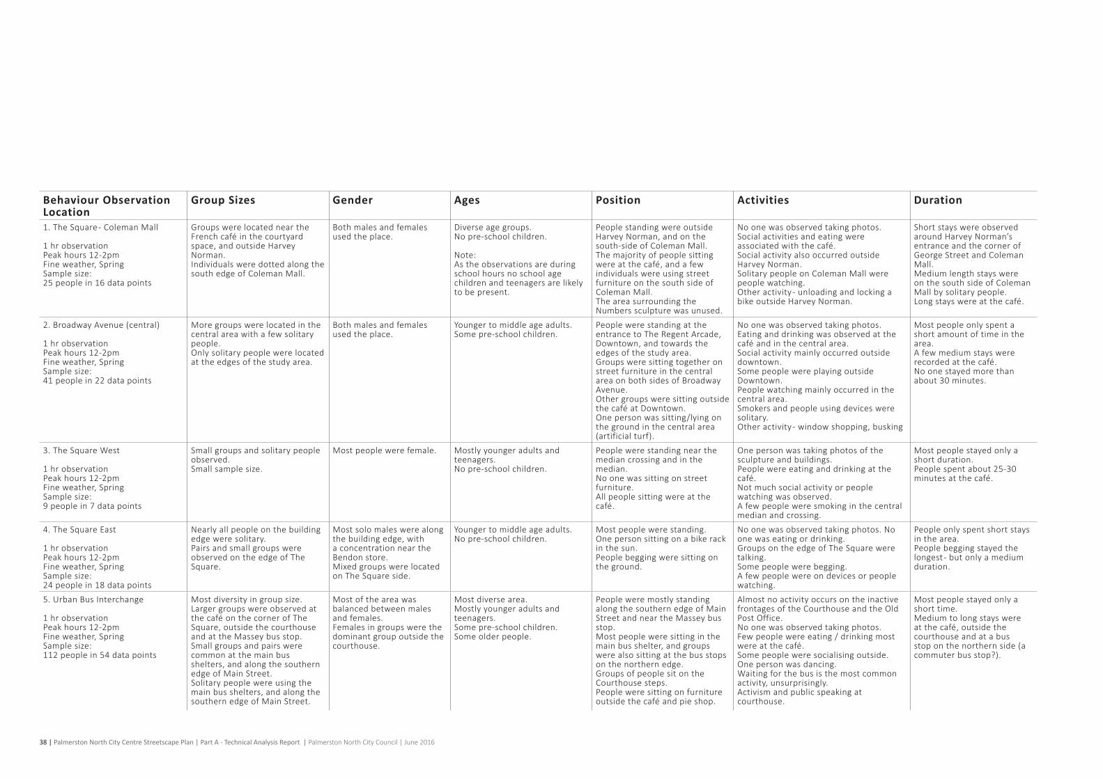
Behaviour Observation Location
Group Sizes Gender Ages Position Activities Duration
1. The Square - Coleman Mall
1 hr observationPeakhours12-2pmFineweather,SpringSamplesize:25 people in 16 data points
GroupswerelocatedneartheFrenchcafé in the courtyard space,andoutsideHarveyNorman.Individuals were dotted along the south edge of Coleman Mall.
Bothmalesandfemalesused the place.
Diverseagegroups.No pre-school children.
Note:Astheobservationsareduringschool hours no school age childrenandteenagersarelikelyto be present.
People standing were outside HarveyNorman,andonthesouth-side of Coleman Mall. Themajorityofpeoplesittingwere at the café,andafewindividuals were using street furniture on the south side of Coleman Mall.The area surrounding the Numbers sculpture was unused.
Noonewasobservedtakingphotos.Social activities and eating were associated with the café.Social activity also occurred outside HarveyNorman.Solitary people on Coleman Mall were people watching.Otheractivity-unloadingandlockingabikeoutsideHarveyNorman.
Short stays were observed aroundHarveyNorman’sentrance and the corner of GeorgeStreetandColemanMall.Medium length stays were on the south side of Coleman Mall by solitary people.Long stays were at the café.
2.BroadwayAvenue(central)
1 hr observationPeakhours12-2pmFineweather,SpringSamplesize:41 people in 22 data points
More groups were located in the central area with a few solitary people.Onlysolitarypeoplewerelocatedat the edges of the study area.
Bothmalesandfemalesused the place.
Younger to middle age adults.Some pre-school children.
People were standing at the entrancetoTheRegentArcade,Downtown,andtowardstheedges of the study area.Groupsweresittingtogetheronstreet furniture in the central areaonbothsidesofBroadwayAvenue.Othergroupsweresittingoutsidethe caféatDowntown.Onepersonwassitting/lyingonthe ground in the central area (artificial turf).
Noonewasobservedtakingphotos.Eatinganddrinkingwasobservedatthecafé and in the central area.Social activity mainly occurred outside downtown.Some people were playing outside Downtown.People watching mainly occurred in the central area.Smokersandpeopleusingdevicesweresolitary.Otheractivity-windowshopping,busking
Most people only spent a short amount of time in the area.Afewmediumstayswererecorded at the café.No one stayed more than about 30 minutes.
3.TheSquareWest
1 hr observationPeakhours12-2pmFineweather,SpringSamplesize:9 people in 7 data points
Small groups and solitary people observed.Small sample size.
Most people were female. Mostly younger adults and teenagers.No pre-school children.
People were standing near the median crossing and in the median.No one was sitting on street furniture.Allpeoplesittingwereatthecafé.
Onepersonwastakingphotosofthesculpture and buildings.Peoplewereeatinganddrinkingatthecafé.Not much social activity or people watching was observed.Afewpeopleweresmokinginthecentralmedian and crossing.
Most people stayed only a short duration.People spent about 25-30 minutes at the café.
4.TheSquareEast
1 hr observationPeakhours12-2pmFineweather,SpringSamplesize:24 people in 18 data points
Nearly all people on the building edge were solitary.Pairs and small groups were observed on the edge of The Square.
Most solo males were along thebuildingedge,witha concentration near the Bendonstore.Mixedgroupswerelocatedon The Square side.
Younger to middle age adults.No pre-school children.
Most people were standing.Onepersonsittingonabikerackin the sun.People begging were sitting on the ground.
Noonewasobservedtakingphotos.Noonewaseatingordrinking.GroupsontheedgeofTheSquareweretalking.Some people were begging.Afewpeoplewereondevicesorpeoplewatching.
People only spent short stays in the area.People begging stayed the longest - but only a medium duration.
5.UrbanBusInterchange
1 hr observationPeakhours12-2pmFineweather,SpringSamplesize:112 people in 54 data points
Most diversity in group size.Larger groups were observed at the café on the corner of The Square,outsidethecourthouseand at the Massey bus stop.Small groups and pairs were common at the main bus shelters,andalongthesouthernedge of Main Street.Solitary people were using the mainbusshelters,andalongthesouthern edge of Main Street.
Most of the area was balanced between males and females.Femalesingroupswerethedominant group outside the courthouse.
Most diverse area.Mostly younger adults and teenagers.Some pre-school children.Some older people.
People were mostly standing along the southern edge of Main Street and near the Massey bus stop.Most people were sitting in the mainbusshelter,andgroupswere also sitting at the bus stops on the northern edge.GroupsofpeoplesitontheCourthouse steps.People were sitting on furniture outside the café and pie shop.
AlmostnoactivityoccursontheinactivefrontagesoftheCourthouseandtheOldPostOffice.Noonewasobservedtakingphotos.Fewpeoplewereeating/drinkingmostwere at the café.Some people were socialising outside.Onepersonwasdancing.Waitingforthebusisthemostcommonactivity,unsurprisingly.Activismandpublicspeakingatcourthouse.
Most people stayed only a short time.Medium to long stays were at the café,outsidethecourthouse and at a bus stop on the northern side (a commuter bus stop?).

Palmerston North City Centre Streetscape Plan | Part A - Technical Analysis Report | Palmerston North City Council | June 2016 | 39
Coleman / The Square
Coleman / The Square
Coleman / The Square
1 hr observationPeak hours 12-2pmFine weather, SpringSample size:25 people in 16 data points
Coleman / The Square
1 hr observationPeak hours 12-2pmFine weather, SpringSample size:25 people in 16 data points
GroupSize
Position
Gender
Activity
Age
DurationofStay
The Square - Coleman Mall
Build-Measure-Learn Process1. Learn: what do we want to find out?2. Measure: how can we measure it?3. Build: what do we need to make to answer the question (minimum viable product/feature)?
1.Whatdowewanttolearn?Canwefacilitatepubliclifewhichisneartothehigherpedestrianflows:
• AroundtheNumberssculpture;• Near the Library entrance and the crossing to The Square;• AlongthesunnysouthernedgeofColemanMall.
Image 11: Square North - Coleman Mall Figure 22: Pedestrian groups
Figure 23: Study results

40 | Palmerston North City Centre Streetscape Plan | Part A - Technical Analysis Report | Palmerston North City Council | June 2016
Broadway - Central area
GroupSize
Position
Gender
Activity
Age
DurationofStay
Broadway - Central area
1 hr observationPeak hours 12-2pmFine weather, SpringSample size: 41 people in 22 data points
Broadway - Central area
1 hr observationPeak hours 12-2pmFine weather, SpringSample size: 41 people in 22 data points
Broadway - Central area
Build-Measure-Learn Process1. Learn: what do we want to find out?2. Measure: how can we measure it?3. Build: what do we need to make to answer the question (minimum viable product/feature)?
1.Whatdowewanttolearn?Thiswastheonlylocationwereadiversityofpubliclifewasoccurring,witharangeofpeople and the only place where play was observed.
Canweextendthedurationandincreasetheamountofpublicactivityinthisarea,by:• Optimisingthelocationoftheassetsthatattractpeople-theconnect4,movable
seating,seatingplatforms;• Layering in additional uses;• Canwegrowthelocationasaplaceforkids/play;• Extendingactivityintocarparkingspaces;• Increase the presence of the café in the street;• IncreaseTheRegentArcade’spresenceandconnectionattheBroadway
intersection.
Broadway Avenue (Central)
Figure 24: Pedestrian groupsImage 12: Broadway Avenue (central)
Figure 25: Study results

Palmerston North City Centre Streetscape Plan | Part A - Technical Analysis Report | Palmerston North City Council | June 2016 | 41
The Square - West
The Square - West
GroupSize
Position
Gender
Activity
Age
DurationofStay
The Square - West
1 hr observationPeak hours 12-2pmFine weather, SpringSample size: 9 people in 7 data points
The Square - West
1 hr observationPeak hours 12-2pmFine weather, SpringSample size: 9 people in 7 data points
Square West
Build-Measure-Learn Process1. Learn: what do we want to find out?2. Measure: how can we measure it?3. Build: what do we need to make to answer the question (minimum viable product/feature)?
1.Whatdowewanttolearn?Canweextendthedurationandincreasetheamountofpublicactivityinthisarea,by:
• Providing activity generators in the widened footpath areas;• IncreasingrelationshipofButterflyPondareatothestreetedge,e.g.provide
features in the grassy area between the pond and street.
Image 13: Square West Figure 26: Pedestrian groups
Figure 27: Study results

42 | Palmerston North City Centre Streetscape Plan | Part A - Technical Analysis Report | Palmerston North City Council | June 2016
The Square - East
The Square - East
The Square - East
1 hr observationPeak hours 12-2pmFine weather, SpringSample size: 24 people in 18 data points
The Square - East
1 hr observationPeak hours 12-2pmFine weather, SpringSample size: 24 people in 18 data points
The Square - East
1 hr observationPeak hours 12-2pmFine weather, SpringSample size: 24 people in 18 data points
Gender
Activity
Age
DurationofStay
GroupSize
Position
Square East
Build-Measure-Learn Process1. Learn: what do we want to find out?2. Measure: how can we measure it?3. Build: what do we need to make to answer the question (minimum viable product/feature)?
1.Whatdowewanttolearn?Thisareahasthelargestpedestrianflowsinthecentralcitystreetscapes:
• Whatkindofpubliclifewillbefacilitatedifspaceiscreatedalongthebuildingside?Whatkindofgroupswilloccupythespace?
• Willpeoplesitalongthissection?Ifso,wherewilltheysit?• Willthisareaattractpeoplewatchingbehaviourifseatingisprovided?Howcanthis
be provided without it becoming intimidating?• Howcanthepublicactivitybeguidedsothatitisperceivedaspositiveand
legitimate?• Howcantheedgeofthestreetwhichinteractswiththeparkbeadaptedto
facilitate the short-term behaviours which occurs along the edge e.g. organising themselves,conversations?
Image 14: Square East Figure 28: Pedestrian groups
Figure 29: Study results

Palmerston North City Centre Streetscape Plan | Part A - Technical Analysis Report | Palmerston North City Council | June 2016 | 43
Urban Bus Interchange - Main St
Urban Bus Interchange - Main St
Urban Bus Interchange - Main St
1 hr observationPeak hours 12-2pmFine weather, SpringSample size: 112 people in 54 data points
Urban Bus Interchange - Main St
1 hr observationPeak hours 12-2pmFine weather, SpringSample size: 112 people in 54 data points
GroupSize
Position
Gender
Activity
Age
DurationofStay
Urban Bus Terminal and Main Street
Build-Measure-Learn Process1. Learn: what do we want to find out?2. Measure: how can we measure it?3. Build: what do we need to make to answer the question (minimum viable product/feature)?
1.Whatdowewanttolearn?Thisareahasthelargestamountofstationarybehaviourinthecentralcitystreetscapes:
• Howcanthelargegroup,andshort-termnatureofpeople’sstayinthisareabeusedasapositivegeneratortopeople’sexperienceofthecity?
• HowcanthesunnylocationbytheMasseybusstopcreateapositiveexperienceforbus users and the people passing through the area;
• HowcanwefacilitatethegroupbehaviourandvitalityoftheCoffeeClubcorner,bothwithpatronsandthepublicsothatthespacedoesnotbecomeprivatised,butthepublicactivitydoesnotimpactthecustomerexperience;
• HowcantheexperiencearoundtheCourthousebeimprovedsothatpeoplewaiting for the court are not forced to sit on the steps or be separated from the bus passengers,andothermembersofthepublic?
Image 15: Urban Bus Terminal and Main Street Figure 30: Pedestrian groups
Figure 31: Study results

44 | Palmerston North City Centre Streetscape Plan | Part A - Technical Analysis Report | Palmerston North City Council | June 2016
Image 16: Existing wayfinding signage
2. 8 Access and Movement - WayfindingThe ease with which users can move around and access the study areaiscapturedinthewayfindingdiagramatFigure32.Theanalysisidentifies:
• Aclearstructureof‘nodal’pointsaroundTheSquarethatare supported to varying degrees of success by associated landmarkstructuresand/orkeyviews;
• Sense of arrival into The Square could be enhanced by improvingthebuiltform,landscapequalityandviews,andreducing roading dominance;
• TheRangitikeiandFitzherbertAvenuenodesprovidegoodaxialviewconnectionsbuthaveweakcharacterdominatedbyroading;
• Main Street east is separated from The Square by a barrier of plantingandaroundaboutthatweakensthefunctionofthisnode;
• Church Street west is well supported by heritage quality buildings,hasgoodviewconnectionsbutpartsofthenodalspacearebland/unremarkableandpoorlydefined;
• Church Street east has good activation and has reasonable landmarkstructuresbutneedstoprovidebetterlinkstoTheSquare and resolve pedestrian movement needs.
• TheBroadwayAvenuenodeisimportantbutnotwellsupportedbyadjacentbuildingqualityandhaspoorstreetspace/junctiondefinition;
• Otherwayfindingfeaturesincludeprimaryentrancesthat should have greater coordination with streetscape treatments,providingcelebrationofthisbusiermemorablelocations.
Observationalstudiesofpedestrianmovementrevealedthattheplacementofstreetfurnituresuchasbins,parkingmetersisnotassociated with movement and way-finding. The placement causes intermediate locations to be visited by pedestrians before they head towards their destination (often observed on the other side of the road). Careful placement (triangulation) and design of the wayfinding,streetdesign(crossingopportunities)streetfurnitureandparkingassetsfroma‘user-journey’perspectivewouldimprovetheoverallexperienceofcitycentrevisits.
The streetscape design and edge of The Square needs greater attentionmid-blockwithpathwaysandwayfindingsupportingformal routes and desire lines which are currently unmet. SubsequentlandscapeprojectsmayberequiredwithinTheSquare.
Constraints• Need to facilitate vehicular movement as well as achieve
greaterplacemakingandpedestrianupgradeofjunctions;• Retainagreenstreetscapewhileenhancingstrategicviews
into and across The Square;• Buildingupgradesatkeynodesarereliantonprivatesector
investment.
Opportunities• Createasequenceofclear,memorablenodesaroundthe
edge of The Square;• TransformtheUrbanBusTerminaltocreateaquality
landmark;• Removebarriersandclutterfromkeyjunctions;• ReinforceviewsintoTheSquarebyframingviewshaftswith
planting and streetscape materials.

Palmerston North City Centre Streetscape Plan | Part A - Technical Analysis Report | Palmerston North City Council | June 2016 | 45
KEY
Primary building entrances
W Key wayfinding point
Defined nodal points
Street feature
Landscape feature / enclosure
Barrier / clutter
Good visual integration with The Square
Strong landmark
Basic landmark
Weak landmark
W
W
W
W
W
W
W
W
W
W
Figure 32: Access and movement - wayfinding
Broadway Avenue
Berrymans Lane
Maple Lane
Inner Square
Princess Street
Square East
Regent Arcade
Broadway Service Lane
Fitzherbert Avenue
Ashley Street
Square West
Church Street
Main Street EastMain Street West
Coleman Mall
Cuba Street
King Street
Rangitikei Street
Square North
Courthouse
Downtown
UCOL
The Plaza
PNCC
The Regent
on Broadway
Library
High Flyersi.Site
Church Street

46 | Palmerston North City Centre Streetscape Plan | Part A - Technical Analysis Report | Palmerston North City Council | June 2016
2. 9 Access and Movement - CPTEDIssuesGenerally Publicconsultationrevealedwherepeoplefeelsafeandunsafewithintheprojectarea.ReferFigure33which
relatestoafterdark.Tendenciestofeelunsafevarywithintheprojectarea.CPTEDreviewfoundsomeofthespacesriskyconsideredbythosesurveyedareindeedso.Thisisduetothefactorsdescribedbythosesurveyedalong with other factors found from the review. Some of the ‘red’ spaces are not unsafe but can be perceived to berisky.
After Hours Insomeareas(showninred)thereisalackofotherpeopletogiveasenseofsafetyinnumbers.Thepresenceofotherpeople,CityHostsandPolicecanhaveamarkedeffectonsafety.CityHostsandthePolicehaveanexcellentpresenceintheCBD,particularlyatproblematictimesinvolvingalcoholfuelleddisorderassociatedwiththelatenight economy – Thursday night to early Sunday morning.ItwasnotedhowactiveandsafeTheSquareisduringthedayandespeciallyafterdark.Thefactitisusedafterhourshighlightsthelackofhumanscalespaceselsewhereintheprojectarea.
Lighting Thereisalackofconsistentlightinginthe“redareas”[surveywasbeforetheunder-verandaupgrades].Lightinglevels are much improved along The Square frontages with the introduction of new under-veranda lighting. Many areas,suchasthelanewayshaveinsufficientorpoorqualitylighting.PartsoftheCBDareoverlitandpoorlylit.Unsophisticatedandexcessiveuseofcolouredlightshascreatedanillegible nightscape – the building edges of The Square are lost; and the effect of special lighting (such as the clocktower)andotherwayfindinglightinghasbeensignificantlydiminished.
Laneways Lanewaysareimportantforpromotingconvenientmid-blockaccessandNorth/Southconnections.ForexamplethelinkagesbetweentheCBDandthetheatre,commercialpremisesonQueenStreetandthepolytechnicpromotevitality,business,recreationandconvenience.
Vacant Lots Sitesawaitingdevelopmentwithhiddenenclaves,poorlighting,rubbishandthelikeareusedforantisocialpurposes(drinking,congregation,soiling,disorder).
Bus Interchange The bus interchange conflicts with other uses and pedestrian traffic during the late night economy. It is currently usedforpatronandunder-agedcongregation,soiling,ambulancestop,policestop,andthelike.Ithasapoorconnection to The Square.
Pedestrian Crossings
Those surveyed reported that the pedestrian crossings around The Square are busy and intimidating.
Disorder Disorderlypeopleofteninstilfearinothersanddeteroccupationbyawiderrangeofpeoplethanbargoersafterhours.Disorderisassociatedwiththenighttimeeconomy.Duringthedaythereareconcernsaboutasmallnumberofpersistentbeggars,visitorstothecourthouseandloiterersatthemainbusinterchange.Footpathcrowding and disorder affects safe movement.
Toilets Havinggoodtoiletfacilitiespromotesthesafe,hygienicandsustaineduseofpublicspace.Alackofconvenientlyaccessibletoiletfacilitiescausepeopletotakerisksdownalleys,indoorrecesses,andvacantlots.Itcreatessoiling in these areas. Soiling contributes to engendering a sense of fear of crime.
Universal Access Noted:• Severecrossfall(>1:10)onfootpaths.• Difficultiesnegotiatingrampsandkerbsatpedestriancrossings.• “Stony”pathways.• Finebrokenglassonfootpaths.
OpportunitiesThespacesshownas‘red’inFigure33arecapableofbeingmadetofeelsaferandbesafer.Themethodsforimproving safety and the sense of safety are set out below.
There are opportunities to get more ‘eyes on the street’ by activating building edges better by day and by night. PublicspacesintheCBDcouldalsobemademoreenticingtoencouragepeopletostayinpleasantspacesratherthan move through.TheCBDcouldbenefitfrommorehumanscale,sheltered,pleasantspacesinthepublicrealmwithoutobligationto buy from the premises providing seating on the footpath (this is one reason the mall is so successful).
ThereisasignificantopportunitytodevelopaCBDLightingPlanwhich:• Helpsactivateedges.• Showcasesworthyartworks,sculptures,buildingfaçadesespeciallyalongtheedgesofTheSquare.• Improveslegibilityandwayfinding,includingsignallingalleywayentrancesandactivitynodestherein.• Makesthrough-blockconnectionssafer.• SupportsCCTVbetter.
Lanewayscouldbeimprovedby:• More legible entry thresholds.• Activatingedges.• Improvesafety/CPTED.• Upgrading lighting.• Control access to insecure private rear yards.• Securing rubbish holding and storage areas.
Thereisanopportunitytoimplementtemporarysecuritymeasurestomakevacantsitesbeandseemsafer.Christchurchhasmanyexamplesofthis.
Thereisanopportunitytomakethebusinterchangeasafer,morepositive,betterutilised,flexiblespacewithhumanscaleamenity,shelter,betterconnectionstoTheSquareandpositiveusesafterhourswhenthebusesstop running.
AstrongerandseeminglyeasierconnectiontoTheSquarewouldhelpactivateallstreetsintheCBDthatconnectwith it.
Environmentalimprovementscanhaveasignificanteffectonminimisingantisocialbehaviour–thethrustofCPTED.Someofthisdisorderisassociatedwithtightqueuingspacesoutsidebars,lackofspaceoutsidefastfoodoutlets,andfewchoicesoutsideofTheSquaretodisengageintosafe,supervised,qualityspaces.
Thereareopportunitiestoprovidemoresafe,dispersed,publictoiletfacilities.ThetwoinTheSquareafterhoursget overloaded on city ‘party nights.’
AuniversalaccessstudywouldsupportCBDdevelopment.

Palmerston North City Centre Streetscape Plan | Part A - Technical Analysis Report | Palmerston North City Council | June 2016 | 47
KEY
Safe
Unsafe
Dangerous pedestrian crossings
Beggars
Broadway Avenue
Berrymans Lane
Maple Lane
Inner Square
Princess StreetPrincess Street
Square East
Regent Arcade
Square West
Church Street Church Street
Main Street
Coleman Mall
Cuba Street
King Street
1
1
2
DarkScaryNo lightingOverspill from courthouse
NighttimeDark, scary
Ugl
y
LightingCourthouse
Nig
htti
me
Day
tim
e
Anytime
Nighttime
Anytime
Little Cuba
Kids congregating
Dark, scary
Bird
poo
Bird poo Bird poo
Safe at night
Ugl
y
Buses**
Anytime
Nig
htti
me
The Regent
on Broadway
UCOL
The Plaza
PNCC
i.Site
Thefigureaboveshowsfeedbackreceivedatstakeholderengagementworkshops,capturingareaswherethecommunityfeelssafeandunsafe,andatwhattimes.
Main Street
Figure 33: Access and movement - Crime Prevention Through Environmental Design (CPTED)
Image 17: General safety concerns Image 18: Laneway Image 19: Laneway Image 20: Laneway
Image 21: Inconsistent lighting Image 22: Vacant lots Image 23: Urban Bus Terminal
Image 24: Footpath crowding and disorder Image 25: Public toilets Image 26: Universal access issues

48 | Palmerston North City Centre Streetscape Plan | Part A - Technical Analysis Report | Palmerston North City Council | June 2016
2. 10 Access and Movement - Street StructureThestudyareacomprisespartofamuchlargeropengridsystem,with a high level of route choice for vehicles. Management of movements is therefore difficult and past observations have demonstrated a high proportion of traffic entering the study area (centralCBD)passingstraightthrough.Trafficvolumesinthestudyarea are therefore higher than necessary to service the activities contained within and around it.
Alloftheroadswithinthestudyareaareidentifiedas‘PlaceStreets’intheCityCentreFramework,withtheexceptionofpartofMainStreet,whichtotheeastoftheUrbanBusTerminalisa‘Movement/Place Street’. These streets should therefore provide accesstoactivities,withahighlevelofaccessibilityandprioritygiventopedestrians,ratherthanaccommodatingthethroughvehicular movements which currently occur.
Thehighlevelsofon-streetparkingthroughoutthestudyareaandshortblocklengthsresultinalowaveragevehiclespeed,withaveragesforeachsectionfallinginthe22kphto32kphrange.
Image 27: The Square circa 1942 previously subdivided by the street network

Palmerston North City Centre Streetscape Plan | Part A - Technical Analysis Report | Palmerston North City Council | June 2016 | 49
AA
BB
CC
DD
EE
FF GG
KEY
Section line locations
Constraints• ThesizeofTheSquarecanaddsignificantwalktimesfor
thosewithreducedmobilityunlessparkingisprovidedonallsectionsoftheperimeter,effectivelyreducingthewalkabilityoftheCBD.Vehicularaccessmustthereforeberetainedtoalllocations;
• The open nature of the grid means that route prediction and therefore management of traffic can be difficult.
Opportunities• Thegridsystemprovidesin-builtresiliencetothenetwork
andtoacertainextentprovidesadequatechoicefortrafficto‘self-regulate’,reducingtheoccurrenceofsignificantcongestion;
• The high level of accessibility and vehicular permeability providesopportunitiesforsomelinkstoberestrictedwhilemaintaining access to all locations;
• Theringroadoperateswellbelowcapacity,withefficiencygains possible with increased use (i.e. programming signals to favour the ring road over side roads; enabling ‘green waves’ to improvetraveltimesandjourneyreliability).
Figure 34: Access and movement - street structure section locations
Broadway Avenue
Berrymans Lane
Maple Lane
Inner Square
Princess Street
Square East
Regent Arcade
Broadway Service Lane
Fitzherbert Avenue
Ashley Street
Square West
Church Street
Main Street EastMain Street West
Coleman Mall
Cuba Street
King Street
Rangitikei Street
Square North
Courthouse
Downtown
UCOL
The Plaza
PNCC
The Regent
on Broadway
Library
High Flyersi.Site
Church Street

50 | Palmerston North City Centre Streetscape Plan | Part A - Technical Analysis Report | Palmerston North City Council | June 2016
Section AA: Square West (north section)Total Street ≈ 29.50mCarriageway≈23.70m(kerbfacetokerbface)
• The carriageway supports a single vehicle lane in either direction(bothexceeding3.2m),andon-streetparking.
Footpaths≈5.80m(total)• Thewesternfootpathsupportsstreetinfrastructure,and
allows unobstructed circulation.• The narrow footpath width to the east may not allow for
equitable access (dependent upon street infrastructure locations).
• Footpathgradesarenotknown.• Retailfrontagestypicallyprovidebuiltweatherprotectionto
the pavement. There is no built weather protection to the footpathadjacentTheSquare,howevermaturetreecanopyprovides some shelter from sunlight.
Planting• Establishedtreesareplantedinthegenerousmedian.There
are no street trees along the building edge.
Section BB: Square West (south section)Total Street ≈ 29.75mCarriageway≈17.50m(kerbfacetokerbface)
• The carriageway supports a single vehicle lane in either direction(bothexceeding3.2m),andon-streetparking.
Footpaths≈8.60m(total)• Thewesternfootpathsupportsretailspillout,street
infrastructure,andallowsunobstructedcirculation.• The narrow footpath width to the east may not allow for
equitable access (dependent upon street infrastructure locations).
• Footpathgradesarenotknown.• Retailfrontagestypicallyprovidebuiltweatherprotectionto
the pavement. There is no built weather protection to the footpathadjacentTheSquare,howevermaturetreecanopyprovides some shelter from sunlight.
Planting• Establishedtreesareplantedinthegenerousmedianand
there are recently planted street trees along the building edge.
Section AA: Square West (north section)
Section BB: Square West (south section)

Palmerston North City Centre Streetscape Plan | Part A - Technical Analysis Report | Palmerston North City Council | June 2016 | 51
Section CC: Church StreetTotal Street ≈ 31.11mCarriageway≈32.34m(kerbfacetokerbface)
• The carriageway supports a single vehicle lane in either direction(bothexceeding3.2m),andfourbusparkinglanes(totalling≈18.82m).
Footpaths≈5.41(total)• Thefootpathsdonotallowforunobstructedcirculation,with
streetinfrastructure(lighting,bins,bicyclehoops)andretailspillout included within the above measurements.
• Thenarrowfootpathwidth,particularlytothesouth,maynot allow for equitable access (dependent upon street infrastructure locations).
• Footpathgradesarenotknown.• Retailfrontagestypicallyprovidebuiltweatherprotection
to the pavement. There is no built weather protection to footpathadjacentTheSquare,howevermaturetreecanopyprovides some shelter from sunlight.
Planting• Establishedtreesareplantedwithinthemedian.
Section DD: Square East (south section)Total Street ≈ 30.09mCarriageway≈24.19m(kerbfacetokerbface)
• The carriageway supports a single vehicle lane in either direction(bothexceeding3.2m),andfourbusparkinglanes(totalling≈18.82m).
Footpaths≈5.90(total)• Thefootpathsdonotallowforunobstructedcirculation,with
streetinfrastructure(lighting,bins,bicyclehoops)andretailspillout included within the above measurements.
• Inaddition,thenarrowfootpathwidth,particularlytothewest,maynotallowforequitableaccess(dependentuponstreet infrastructure locations).
• Footpathgradesarenotknown.• Retailfrontagestypicallyprovidebuiltweatherprotection
to the pavement. There is no built weather protection to footpathadjacentTheSquare.
Planting• There are few established trees planting within the median.
Section CC: Church Street
Section DD: Square East (south section)

52 | Palmerston North City Centre Streetscape Plan | Part A - Technical Analysis Report | Palmerston North City Council | June 2016
Section EE: Main Street East - Urban Bus TerminalTotal Street ≈ 39.64mCarriageway≈32.34m(kerbfacetokerbface)
• The carriageway supports a single vehicle lane in either direction(bothexceeding3.2m),andfourbusparkinglanes(totalling≈18.82m).
UrbanBusTerminal• TheUrbanBusTerminalcanopiesareindustriallyscaled,
visually dominating the streetscape and providing little weather protection to commuters.
Footpaths≈7.30m(total)• The footpaths are not appropriately scaled to support the
pedestrian numbers along Main Street.• Footpathgradesarenotknown.• There is little weather protection provided on the footpaths.
Planting• FourestablishedtreesareplantedwithinthemedianatThe
Square,withunderstoreyplanting.Section EE: Main Street - Urban Bus Terminal
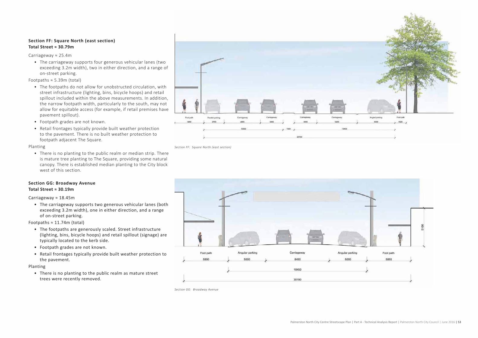
Palmerston North City Centre Streetscape Plan | Part A - Technical Analysis Report | Palmerston North City Council | June 2016 | 53
Section FF: Square North (east section)Total Street ≈ 30.79m
Carriageway≈25.4m• The carriageway supports four generous vehicular lanes (two
exceeding3.2mwidth),twoineitherdirection,andarangeofon-streetparking.
Footpaths≈5.39m(total)• Thefootpathsdonotallowforunobstructedcirculation,with
streetinfrastructure(lighting,bins,bicyclehoops)andretailspilloutincludedwithintheabovemeasurements.Inaddition,thenarrowfootpathwidth,particularlytothesouth,maynotallowforequitableaccess(forexample,ifretailpremiseshavepavement spillout).
• Footpathgradesarenotknown.• Retailfrontagestypicallyprovidebuiltweatherprotection
to the pavement. There is no built weather protection to footpathadjacentTheSquare.
Planting• There is no planting to the public realm or median strip. There
ismaturetreeplantingtoTheSquare,providingsomenaturalcanopy.ThereisestablishedmedianplantingtotheCityblockwest of this section.
Section GG: Broadway AvenueTotal Street ≈ 30.19m
Carriageway ≈ 18.45m • The carriageway supports two generous vehicular lanes (both
exceeding 3.2m width), one in either direction, and a range of on-street parking.
Footpaths ≈ 11.74m (total)• The footpaths are generously scaled. Street infrastructure
(lighting, bins, bicycle hoops) and retail spillout (signage) are typically located to the kerb side.
• Footpath grades are not known.• Retail frontages typically provide built weather protection to
the pavement.Planting
• There is no planting to the public realm as mature street trees were recently removed.
Section FF: Square North (east section)
Section GG: Broadway Avenue

54 | Palmerston North City Centre Streetscape Plan | Part A - Technical Analysis Report | Palmerston North City Council | June 2016
2. 11 Built Form - Figure Ground Study
The SquarePalmerston North, New Zealand
Bryant ParkNew York City, USA
Trafalgar SquareLondon, England
425m
Figures35and36presentasame-scalecomparativeexerciseofTheSquareinPalmerstonNorthwithprecedentsfromtheUK,NorthAmericaandContinentalEurope.
TheSquareisaverylargespacebycomparison,afactthatis accentuated by the relatively low scale of the buildings that contain and define the space. The earlier subdivision of The Square into quadrants (Image 25 on page 48) is perhaps testimony to the recognition that the scale of the space required reductionandcouldaccommodateastreetnetworkwithinit.
TrafalgarSquare,London’spre-eminenturbanspaceissmallerthanTheSquareandactivatedbylargesculpturalfeatures,waterdisplaysandfrontedbytheNationalGallery.EachsideofTrafalgar Square has a different built character and function. The SquareatPalmerstonNorthperhapssuffersfromlackofahighlyvisiblegrandfeaturebuildingthatactivatesanedge,withallbounding streets being of a similar character. The old post office building has the potential to fulfil a more vital role for The Square and should be a focus of future investment and design attention.
BryantParkinNewYorkcouldbecontainedwithinhalfofTheSquare,ascouldBedfordSquare(London)orthePiazzaDelCampo (Sienna). The implications of this large scale suggest the need for The Square to provide a variety of types of setting (i.e. notjustonetypeofspaceoredgecondition)andtopursueadesign approach that reinforces the different functions of the edges of The Square.
Figure 35: Figure ground studies


