Quaternary Science Reviews, Vol. 10, pp. 537-544, 1991. 0277-3791/91 $0.00 + .50 Printed in Great Britain. All fights reserved. ~) 1991 Pergamon Press plc PALYNOLOGICAL RECORDS OF THE LAST 11,000 YEARS IN CHINA Sun Xiangjun and Chen Yinshuo Institute of Botany, Academia Sinica, Beijing 100093, China Palynological research has been carried out for over 30 years at Holocene sites covering almost all of continental China, most of which are in the eastern part of northeast China, coastal areas, the southwestern plateau and the Qinghai-Tibetan Plateau (Fig. 1 and Table 1). However, there remain many difficulties in reconstructing vegetational and climatic history in the postglacial period because many pollen data do not have a chronological control independent of .pollen records. In addition, large sampling intervals in many published pollen diagrams make it impossible to trace abrupt geological or climatic events, which have been attracting great interest among Quaternary researchers in recent years. This paper attempts to synthesize Chinese Holocene pollen data with relatively reliable chronological control, and to discuss the vegetational and climatic significance of these findings. As the Quaternary vegetation is the direct ancestor of the modern flora, and the modern geographical distribution of vegetation is the result of the historical development of past vegetation, this paper will discuss pollen data in the context of the modern vegetation zones within which pollen sites are located. As pollen data in the Chinese subarctic areas are not available, and as those in southern subtropical areas are very scarce and have identification problems, these areas will not be dealt with here. Neither will pollen data from Taiwan be reviewed. TEMPERATE MIXED CONIFER AND BROAD-LEAVED DECIDUOUS FOREST REGION The modern regional vegetation of the eastern part of northeast China is mixed deciduous and Korean pine forest, distributed at 800-1000 m a.s.l, in the Changbai Mountain area, and 500-700 m a.s.l, in the Sanjian Fluvial Plain and Wanda Mountain area. Most pollen data in this region are from the Changbai Mountain area and the Sanjiang plain. The general characteristics of approximately 20 pollen profiles with radiocarbon dating are as follows. 13-11 ka BP. Represented by a peat profile in Gushantun, Huinan County, Jilin Province (Liu, 1989). In this period pollen diagrams show a very low pollen sedimentation rate (about 500 grains/cm2.year). Arboreal pollen is 35-40% of the total pollen, with Betula (40% of tree pollen) and Picea/Abies (25% of tree pollen) as dominant elements. Deciduous tree pollen such as Ulmus, Tilia and Fraxinus is less than 15% of the total. This assemblage is compatible with a modern surface sample from the Betula ermanii zone and lower part of the tundra zone on the northern slope of Changbai Mountain, and is therefore considered as representative of a forest-tundra vegetation. It indi- cates a temperature at least 6-8°C lower than today. 11-10 ka BP. Betula pollen dominates the pollen assemblage (40-70%) with a decrease in Picea/Abies. Quercus has its first consistent appearance. Pollen sedimentation rates increase greatly, reaching 2000 grains/cm2.year. This clearly indicates a replacement of former forest-tundra vegetation by Betula forest. This vegetation might have been distributed over a large area, from mountains around the Sanjiang Fluvial Plain (Xia, 1983; Ye et al., 1983) to the Changbai Mountain area. At 900 m a.s.l, on Changbai Mountain, however, this replacement might have taken place about 1 ka later (Yuan and Sun, in press). 10-4 ka BP. Pollen of broad-leaved deciduous trees dominates, with Betula decreasing very sharply. This stage also sees a great increase in pollen sedimentation rate (3,000-10,000 grains/cm2.year). In most profiles, the earlier stage (10-8 ka BP) is characterized by high Ulmus content and the later (8-4 ka BP) by high Quercus percentages, while in some other profiles (Sun et al., in press) Quercus dominates pollen assemblages from 10 ka BP. It is inferred that during this period large areas of the eastern part of the northeast China plain were covered by broad-leaved deciduous forests, of which Quercus, Ulmus, Tilia, Fraxinus and Acer are the main elements. Pollen assemblages of compatible age from the Sanjiang Fluvial Plain and other sites lower than 900 m a.s.1, generally contain very few Pinus and Betula pollen grains (usually less than 10%), much lower than those in any modern pollen rain (even those from the lowland of the Changbai Mountain area) while the higher altitudes of the Changbai Mountain area (above 900 m a.s.l.) have percentages that are much higher (10-20% for Pinus and 20-40% for Betula). This suggests that during this period, Pinus and Betula were distributed only in areas higher than 900 m a.s.l. The climate at that time might well have been warmer than it is today. 4 ka BP-present. Pollen assemblages from this period are characterized by a great increase in Pinus pollen. The time of this increase is variable in different sites, but in general is about 5-4 ka BP. It is very likely 537
Transcript
Quaternary Science Reviews, Vol. 10, pp. 537-544, 1991. 0277-3791/91 $0.00 + .50 Printed in Great Britain. All fights reserved. ~) 1991 Pergamon Press plc
P A L Y N O L O G I C A L R E C O R D S O F T H E L A S T 11,000 Y E A R S I N C H I N A
Sun Xiangjun and Chen Yinshuo Institute of Botany, Academia Sinica, Beijing 100093, China
Palynological research has been carried out for over 30 years at Holocene sites covering almost all of continental China, most of which are in the eastern part of northeast China, coastal areas, the southwestern plateau and the Qinghai-Tibetan Plateau (Fig. 1 and Table 1). However, there remain many difficulties in reconstructing vegetational and climatic history in the postglacial period because many pollen data do not have a chronological control independent of .pollen records. In addition, large sampling intervals in many published pollen diagrams make it impossible to trace abrupt geological or climatic events, which have been attracting great interest among Quaternary researchers in recent years. This paper attempts to synthesize Chinese Holocene pollen data with relatively reliable chronological control, and to discuss the vegetational and climatic significance of these findings.
As the Quaternary vegetation is the direct ancestor of the modern flora, and the modern geographical distribution of vegetation is the result of the historical development of past vegetation, this paper will discuss pollen data in the context of the modern vegetation zones within which pollen sites are located. As pollen data in the Chinese subarctic areas are not available, and as those in southern subtropical areas are very scarce and have identification problems, these areas will not be dealt with here. Neither will pollen data from Taiwan be reviewed.
TEMPERATE MIXED CONIFER AND BROAD-LEAVED DECIDUOUS FOREST REGION
The modern regional vegetation of the eastern part of northeast China is mixed deciduous and Korean pine forest, distributed at 800-1000 m a.s.l, in the Changbai Mountain area, and 500-700 m a.s.l, in the Sanjian Fluvial Plain and Wanda Mountain area. Most pollen data in this region are from the Changbai Mountain area and the Sanjiang plain. The general characteristics of approximately 20 pollen profiles with radiocarbon dating are as follows.
13-11 ka BP. Represented by a peat profile in Gushantun, Huinan County, Jilin Province (Liu, 1989). In this period pollen diagrams show a very low pollen sedimentation rate (about 500 grains/cm2.year). Arboreal pollen is 35-40% of the total pollen, with Betula (40% of tree pollen) and Picea/Abies (25% of tree pollen) as dominant elements. Deciduous tree
pollen such as Ulmus, Tilia and Fraxinus is less than 15% of the total. This assemblage is compatible with a modern surface sample from the Betula ermanii zone and lower part of the tundra zone on the northern slope of Changbai Mountain, and is therefore considered as representative of a forest-tundra vegetation. It indi- cates a temperature at least 6-8°C lower than today.
11-10 ka BP. Betula pollen dominates the pollen assemblage (40-70%) with a decrease in Picea/Abies. Quercus has its first consistent appearance. Pollen sedimentation rates increase greatly, reaching 2000 grains/cm2.year. This clearly indicates a replacement of former forest-tundra vegetation by Betula forest. This vegetation might have been distributed over a large area, from mountains around the Sanjiang Fluvial Plain (Xia, 1983; Ye et al., 1983) to the Changbai Mountain area. At 900 m a.s.l, on Changbai Mountain, however, this replacement might have taken place about 1 ka later (Yuan and Sun, in press).
10-4 ka BP. Pollen of broad-leaved deciduous trees dominates, with Betula decreasing very sharply. This stage also sees a great increase in pollen sedimentation rate (3,000-10,000 grains/cm2.year). In most profiles, the earlier stage (10-8 ka BP) is characterized by high Ulmus content and the later (8-4 ka BP) by high Quercus percentages, while in some other profiles (Sun et al., in press) Quercus dominates pollen assemblages from 10 ka BP. It is inferred that during this period large areas of the eastern part of the northeast China plain were covered by broad-leaved deciduous forests, of which Quercus, Ulmus, Tilia, Fraxinus and Acer are the main elements. Pollen assemblages of compatible age from the Sanjiang Fluvial Plain and other sites lower than 900 m a.s.1, generally contain very few Pinus and Betula pollen grains (usually less than 10%), much lower than those in any modern pollen rain (even those from the lowland of the Changbai Mountain area) while the higher altitudes of the Changbai Mountain area (above 900 m a.s.l.) have percentages that are much higher (10-20% for Pinus and 20-40% for Betula). This suggests that during this period, Pinus and Betula were distributed only in areas higher than 900 m a.s.l. The climate at that time might well have been warmer than it is today.
4 ka BP-present. Pollen assemblages from this period are characterized by a great increase in Pinus pollen. The time of this increase is variable in different sites, but in general is about 5-4 ka BP. It is very likely
537
538 X. Sun and Y. Chen
.i. n.. . j
~ : 164 J
/ " ,
/
t
! o 7 4 (J ° 72
~L.
• 63 ~-'" V
S"
°71
°70
°61
v I
0 180 360 540kin i ] I I
J / '
z J
i
\ ~ J
f r - . • i
k IV J J
69 t 067
°23 t _ . . 2 5
II ," I
27
\ \
,5-
.39 / 3o°'~ 3.
54 ° 55
i III a3
r, ~ ,~ .53 ~ 3
-~ L ~ ~'~
~-. , . . i~ 6 o \ k . . . j 2 ~3
o7 .r "~ 14 I \
bo9 .~ 16 /
/
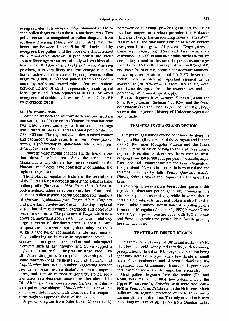
FIG. 1. Present-day phytogeographical regions of mainland China, excluding the subarctic northeast and the subtropical south. (I) - - temperate mixed conifer and broad-leaved deciduous forest; (II) - - temperate broad-leaved forest; (III) - - sub-tropical evergreen broad-leaved forest; (IV) - - temperate grassland; (V) - - temperate desert; (VI) - - alpine plateau .of Qinghai -Xizang
(Tibet). For key to pollen research sites, see Table 1.
that the modern regional mixed pine-decidous forest took shape at about that time. The temperature might have decreased a little from the previous stage and been similar to that of today. Pollen assemblages from about 2 ka BP record the occurrence of Picea and Abies (ca. 10% in the Changbai Mountain area and ca. 20% in the Sanjiang Plain). It is comparable to the modern pollen rain from sites at 1000-1100 m a.s.l., indicating temperatures about 2-3°C lower than today. Tempera- ture recovery, indicated by a decrease of Abies/Picea pollen, took place about a few hundred years before the present day. Also from that time, in the Changbai Mountain area, pine pollen decreases suddenly, and pollen of secondary trees such as some species of Betula and Quercus increases accordingly. This change is not seen in the Sanjiang Plain. It is reasonable to suggest that this change was caused by the activity of early human populations, which might have started at differ- ent times in the Changbai Mountain area and in the Sanjiang Plain. In the former, forest logging began a few hundred years ago, while in the latter, it started only during the present century.
TEMPERATE BROAD-LEAVED FOREST REGION
The regional vegetation of the north China area, including Liaodong Peninsula, is temperate broad- leaved deciduous forest. From the flat fluvial plain in the east to the hills and mountains in the west, the region displays a clear topographical gradient, along which vegetation shows a gradual east-west transition, with conifer forests in areas above 1600 m a.s.l, and broad-leaved forests (Quercus alina, Q. liaotungensis, Q. mongolica, Castanea, Ulmus, Betula and Acer) as the main elements below that. The original forests in this area were mostly destroyed several centuries ago by human activity. Holocene pollen data from the coastal plain and Liaodong Peninsula (the eastern area) and those from the inland (the western area) are to a certain degree different.
Holocene pollen assemblages from the western area are characterized by a considerable amount of pine pollen existing throughout the whole Holocene period. The Fenzhuang profile (Kong and Du, 1980) provides a good example of the vegetation history immediately
Palynological Records 539
TABLE 1. Main Holocene pollen research sites in China
No.* Province Reference
1 Heiiongjiang Xia, 1988 2 Heilongjiang Xia, 1988 3 Heilongjiang Xia, 1988 4 Heilongjiang Ye et al., 1983 5 Jilin Zhou et al., 1984 6 Heilongjiang Yin, 1984 7 Heilongjiang Xiao and Sun, 1987 8 Jilin Peat Study Group, 1983 9 Jilin Sun et al., (in press)
10 Jilin Liu, 1989 11 Jilin Yuan, (in press) 12 Jilin Zhou et al., 1984 14 Jilin Wang and Xia, 1988 15 Jilin Peat Study Group, 1983 16 Jilin Peat Study Group, 1983 17 Jilin Zhou et al., 1984 18 Liaoning Guiyang Institute of Geochemistry, 1977 19 Liaoning Zhao, 1989 20 Hebei Li and Liang, 1985 21 Hebei Kong and Du, 1982 22 Hebei Yan et al., 1981 23 Hebei Xu et al., 1988 24 Shandong Lu, 1989 25 Shandong Lu, 1989 26 Shandong Hart and Meng, 1986 27 Henan Yan et al., 1986 28 Shanxi Ke'and Sun, 1990 29 Jiangsu Meng et al., 1989 30 Jiangsu Wang et al., 1984 31 Jiangsu Sun and Zhang, 1983 32 Zhejiang Meng and Han, 1984 33 Zhejiang Sun et al., 1981 34 Jiangsu Xu et al., 1987 35 Jiangsu X u et aL, 1987 37 Hubei Liu, 1988 39 Hubei Zhou, 1985 40 Sichuan Luo, 1989 41 Zhejiang Yang and Chen, 1982 42 Zhejiang Yang and Chert, 1982 43 Fujian Zheng, 1986 44 Fujlan Chen, 1982 45 Fujian Chert, 1982 46 Yunnan Sun et al., 1986 47 Yunnan Liu et al., 1986 48 Yunnan Wang and Sun, 1986 49 Yunnan Wang and Sun, 1986 50 Yunnan Wang and Sun, 1986 51 Yunnan Wang and Sun, 1986 52 Sichuan Li, 1986 53 Guizhou Lin and Chen, 1982 54 Guizhou Chen and Ren, 1982 55 Guizhou Chen and Ren, 1982 57 I. Mongolia Zhou et al., 1982 59 Gansu Wang, 1987 60 Qinghai Duet al., 1989 61 Qinghai Du and Kong, 1983 63 Xinjiang Yah et al., 1983 64 Xinjiang Wen and Zhen, 1988 65 Tibet Huang et al., 1983 66 Tibet Huang et al., 1983 67 Tibet Wang et al., 1981 68 Tibet Wang, 1981 69 Tibet Wang et al., 1981 70 Tibet Huang et al., 1983 71 Tibet Huang et al., 1983 72 Tibet Huang et al., 1983 73 Tibet Wang et al., 1981 74 Tibet Li et al., 1983 75 Sichuan Wang, 1987 76 Qinghai Wang, 1987 77 Gansu Wang, 1987 78 Gansu Wang, 1987
* No. as shown in Fig. 1.
prior to the Holocene. From 17 to 13 ka BP Artemisia dominates the pollen assemblages (ca. 90%) with very little tree pollen, indicating a tundra vegetation. An increase of conifer pollen such as Larix, Abies and Picea characterizes pollen assemblages between 13 and 11 ka BP, with a few broad-leaved deciduous elements (Betula, Ulmus, Quercus, and Acer), representing a subarctic temperate conifer forest, similar to that growing above 1800 m a.s.l, in the Beijing area today. The climate at that time might have been cold and wet, with a temperature of 6-9°C lower than today. The pollen assemblage from 11.4 to 11 ka BP (only one sample) shows another Artemisia dominance, which may indicate a short-term climatic deterioration, com- parable to the 'Younger Dryas' in Europe (Nilsson, 1983). However, in the same assemblage large numbers of Tilia pollen were found, reaching 20% of the total pollen. It is likely that Tilia grew at some favourable sites as small patches amongst the regional tundra background. This, however, cannot be satisfactorily clarified until further detailed research is carried out. The Xinlizhuang profile (Yan et al, 1981) in the Beijing area, a good example of Holocene pollen data in the western area, is characterized by high pine percentages throughout the Holocene. Its middle part, estimated to extend from 9 to 2 ka BP, sees more broad-leaved deciduous elements, and an increase in the richness of the herbaceous pollen, which may represent a mixed conifer-broad-leaved forest, and indicate the warmest period in the Holocene.
Being closer to the sea, the eastern area shows a different sequence of Holocene vegetation history. Pollen diagrams usually show high herbaceous pollen percentages. In the lower reaches of the Luanhe River (Li and Liang, 1985) herbaceous pollen is constantly around 60% of total pollen, of which Artemisia is the main element. From 10 to 9 ka BP arboreal pollen reaches 20%, with Pinus 40% (of tree pollen), Betula 10-20%, Quercus 20%, some Tilia and Ulmus. Arboreal pollen reaches 40% during the period 9 to 5 ka BP, with a decrease in Pinus, an increase in Ulmus, and the consistent appearance of other warm-loving taxa, such as Acer, Fraxinus, Juglans and Myrtica, representing the warmest period in the Holocene. Since 5 ka BP pine pollen has dominated the AP once more. It may be inferred that in the eastern area of north China, Holocene vegetation consisted of a mixture of grassland and forests, the components of the forests changing through time with broad-leaved deciduous forest in the period 9 to 5 BP, and mixed pine- deciduous forests in other periods of the Holocene.
Pollen data from Liaodong Peninsula raises an interesting problem. Recent palaeoecological research in this area (Zhao, 1989) gave a different and, in our opinion, better explanation of vegetation history, than that provided by earlier work (Guiyang Institute of Geochemistry, 1977). Zhao's work, based on pollen percentage, pollen sedimentation rates, radiocarbon dating and fossil insect data, illustrates that from 11 ka BP vegetation in southern Liaodong Peninsula was
540 x. Sun and Y. Chen
deciduous forest with Ulmus as its main element, with a warm and wet climate, comparable to that of today. The summer temperature might have been higher than today. This was replaced by Quercus forest in 8.3 ka BP and later, at about 5 ka BP by mixed pine deciduous forest. From 2.5 ka BP vegetation in this area was disturbed by human activity. In the classification of the modern Chinese flora, Liaodong Peninsula, together with the north China area, belongs to warm temperate broad-leaved vegetation. From pollen data, however, Holocene vegetation development in Liaodong Penin- sula was rather similar to the northeast China region, and markedly different from north China.
It has long been an accepted idea that, phytogeo- graphically, the north China region belongs to the warm temperate broad-leaved forest zone, and that the absence of forest of this kind in modern vegetation below 1600 m a.s.l, is due to human interference over the past few thousand years. This cannot be justified by pollen data so far obtained. From pollen diagrams discussed above, no real regional broad-leaved deciduous forest has ever existed since the beginning of the Holocene. With the exception of the western mountainous forest, where there existed pine or mixed pine-broad-leaved forest in the Holocene, most parts of the north China region were occupied by grassland, with some patches of pine forst or mixed forest during some periods of the Holocene, showing a sharp contrast with northeast China, where large areas of forest did exist for most of the Holocene. This difference can be attributed to different rainfall in these two regions during the Holocene. Northeast China might have been wetter than north China, and the fluctuation in humidity in the former might have influenced the components, but not the existence, of the forests, while in the latter, insufficient humidity during certain dry periods of the Holocene might have eliminated the forest completely.
SUBTROPICAL EVERGREEN BROAD-LEAVED FOREST REGION
The region is bounded by the Huaihe River and the Qinting Mountains in the north and the eastern slopes of the Tibetan Plateau and western Yunnan in the west and south. The climate is controlled by the east Asian monsoon, being warm and wet with an annual precipi- tation of more than 1000 mm. It can be divided climatically into two areas. Affected by the southeast monsoon in summer and by cold air masses from Siberia in winter, the eastern area is warm and wet in summer and cold in winter. The western area (the Yunnan-Guizhou Plateau and western Sichuan moun- tainous area) is affected by the southwest monsoon, and has a rainy summer and autumn, while in winter and spring it is affected by the western tropical continental dry airmass, the weather usually being warm and dry.
(1) The eastern area. Sites of pollen analysis have been centred on the
middle and lower reaches of the Yangtze River, and the coastal area of Zhenjiang and Fujian Provinces, where the present day vegetation is mixed evergreen and deciduous forest. Pollen assemblages from about 10 ka BP show high percentages of herbaceous pollen, but the consistent presence of warm temperate and sub- tropical evergreen and deciduous tree pollen such as Cyclobalanopsis, Quercus, Betula, Carpinus, Juglans, and Liquidamber indicate such vegetation did exist at that time. They were mixed with Pinus, Cupressaceae on the eastern coast (Xu et al., 1987; Meng et al., 1989) and with Picea and Abies in the western part of the area (Liu, 1989; Zhou, 1985).
Pollen diagrams from Zhenjiang and Nanjing (Xu et al., 1987) show an abrupt increase in herbaceous pollen content at about 11-10 ka BP. Although there might be some problems in stratigraphy and radiocarbon dating, this abrupt climatic deterioration indicated by pollen data is the only case in China that is comparable with the "Younger Dryas" period in Europe.
Remarkable vegetational changes at 10 ka BP (9 ka BP at some sites) are represented in pollen data by (1) an increase in total pollen sedimentation rate, e.g: in the Jianghan Plain (Liu, 1988) and Shennongjia (Zhou, 1985) and (2) an increase in arboreal pollen contents, particularly those of evergreen broad-leaved elements.
It is probable that the rise in temperature after about 10 ka BP reached its maximum at 8 ka BP and ceased at about 5 ka BP (3.5 ka BP at some places), this time interval being the Holocene thermal optimum, during which forests, particularly evergreen, expanded greatly. Surprisingly, the expansion in the warmth- loving forests in this period was accompanied by equally obvious expansion of conifer forests. In the Jianghan Plain and Shennongjia, for instance, warmth- loving broad-leaved elements such as Cyclocarya, Lithocarpus, Quercus and Pterocarya have high pollen percentages and pollen sedimentation rates in pollen diagrams. At the same time conifer elements such as Picea, Abies and Tsuga also reach maximum values. This can be explained as the result of less marked seasonality during this period. The summer tempera- ture might have been comparable to, or even slightly lower than, that of today and the winter temperature higher, which would have allowed both broad-leaved and conifer forest to expand. An alternative explan- ation lies in the vertical distribution of the two forests. The third explanation (Xu et al., 1987) attributes the pollen mixing in the lower reaches of the Yangtze River to long distance water transportation of the conifer pollen from the middle reaches.
Since 5 ka BP, as a result of human activity, pollen assemblages and the vegetation represented by them, have been very diversified. The general trend is an increase in herbaceous pollen contents, perhaps reflect- ing a climatic development towards cooler and/or drier conditions.
In the coastal area south of the Yangtze River,
Palynological Records 541
evergreen elements increase more obviously in Holo- cene pollen diagrams than those in northern areas. Two pollen zones are recognized in pollen diagrams from southern Zhejiang (Meng and Han, 1984), with the lower one between 10 and 9 ka BP dominated by evergreen tree pollen, and the upper one characterized by a remarkable increase in pine pollen and Pteris spores. Since agriculture was already well established at least 7 ka BP (Sun et al., 1981) in Yuyao, Zhejiang province, it is very likely that this change is due to human activity. In the coastal Fujian province, pollen diagrams (Chen, 1982) show pollen assemblages domi- nated by herbs and mixed with a few tree pollens between 12 and 10 ka BP, representing a subtropical forest-grassland. It was replaced at 10 ka BP by mixed evergreen and deciduous forests and later, at 2.5 ka BP by evergreen forest.
(2) The western area. Affected by both the southwestern and southeastern
monsoons, the climate on the Yunnan Plateau has only two seasons (wet and dry) with an annual average temperature of 14-17°C, and an annual precipitation of 700-1400 mm. The regional vegetation is mixed conifer and evergreen broad-leaved forest with Pinus yunna- nensis, Cyclobalanopsis glaucoides and Castanopsis delavayi as main elements.
Holocene vegetational changes are far less obvious than those in other areas. Since the Last Glacial Maximum, a dry climate has never existed on the Plateau, and forests have consistently dominated the regional vegetation.
The Holocene vegetation history of the central part of the Plateau is best demonstrated in the Dianchi Lake pollen profile (Sun et al., 1986). From 13 to 10.5 ka BP pollen sedimentation rates were very low. Pine domi- nates the pollen assemblage with considerable numbers of Quercus, Cyclobalanopsis, Tsuga, Alnus, Carpinus and a few Liquidamber and Carya, indicating a regional vegetation of mixed conifer, evergreen and deciduous broad-leaved forest. The presence of Tsuga, which now grows on mountains above 2700 m a.s.l., and relatively large numbers of deciduous trees, suggest a lower temperature and a wetter spring than today. At about i0 ka BP the pollen sedimentation rate rises remark- ably, indicating an increase in vegetation cover. In- creases in evergreen tree pollen and subtropical elements such as Liquidamber and Carya suggest a higher temperature than the previous stage. From 7 ka BP Tsuga disappears from pollen assemblages, and some warmth-loving elements such as Davallia and Liquidamber increase in number, suggesting another rise in temperatures, particularly summer tempera- tures, and a more marked seasonality. Pollen sedi- mentation rate decreases once more after about 4 ka BP. Although Pinus, Quercus and Castanea still domi- nate pollen assemblages, Liquidamber and Carya and other warmth-loving elements disappear. The tempera- tures begin to approach those of the present.
A pollen diagram from Xihu Lake (2000 m a.s.l.)
northwest of Kunming, provides good data indicating the low temperatures which preceded the Holocene (Lin et al., 1986). The surrounding mountains are about 3000 m a.s.l., the maximum altitude at which modern evergreen forests grow. At present, Tsuga grows in some wet places, but Abies and Picea which are distributed on 3000 m high mountains further north are completely absent in this area. In pollen assemblages from 17 to 10.5 ka BP, however, Abies (5-10% of AP) and Picea (5-20 of AP) occur in considerable numbers, indicating a temperature about 1.5-2.5°C lower than today. Tsuga is also an important element in the assemblage (20-30% of AP). From 10.5 ka BP, Abies and Picea disappear from the assemblages and the percentage of Tsuga drops sharply.
Pollen diagrams from western Yunnan (Wang and Sun, 1986), western Sichuan (Li, 1986) and the Guiz- hou Plateau (Lin and Chen, 1982; Chen and Ren, 1986) show a similar general history of Holocene vegetation and climate.
TEMPERATE GRASSLAND REGION
Temperate grasslands extend continuously along the Songliao Plain (fluvial plain of the Songhua and Liaohe rivers), the Inner Mongolia Plateau and the Loess Plateau, most of which belong to the arid to semi-arid regions. Precipitation decreases from east to west, ranging from 450 to 200 mm per year. Artemisia, Stipa, Rosaceae and Leguminosae are the main elements of the grassland. Carex is important in both grassland and swamps. On nearby hills Pinus, Quercus, Betula, Ulmus, Salix, Corylus and Populus are the main tree taxa.
Palynological research has been rather sparse in this region. Herbaceous pollen generally dominates the Holocene pollen assemblages, while in some sites at certain time intervals, arboreal pollen is also found in considerable numbers. For instance in a pollen profile from inner Mongolia (Zho u et al., 1982) between 7 and 5 ka BP, pine pollen reaches 70%, with 10% of Abies and Picea, suggesting the possibility of forests growing here at that time.
TEMPERATE DESERT REGION
This refers to areas west of 108°E and north of 36°N. The climate is cold, windy and very dry, with an annual precipitation of less than 100 mm, the vegetation being generally desertic in type with a few shrubs or small trees. Chenopodiaceae and Artemisia dominate the vegetation and Gramineae, Rosaceae, Leguminosae and Rannuculaceae are also important elements.
Most pollen diagrams from the region (Du and Kong, 1983; Yan et al., 1983) show a dominance of the Upper Pleistocene by Ephedra, with some tree pollen such as Pinus, Picea, Betula etc. in the Holocene, which indicates the regional presence of these trees and a warmer climate at that time. The only exception is seen in a diagram ( D u e t al., 1989) from Qinghai Lake,
542 x. Sun and Y. Chen
3196 m a.s.l., in which tree pollen has consistently existed since 11 ka BP, reaching maximum numbers during the period 8 to 3.5 ka BP and declining after that. The modern vegetation around the lake is desert and tundra in type, and the surface samples are dominated by herbaceous pollen. It is very likely that during the period 8 to 3.5 ka BP there were forests growing around the lake, and the climate was much warmer and wetter than it is today. The lake is located at the western limit of the southeastern monsoon, which might have brought in some moist air to the area, but a more important factor affecting the local climate is the presence of the lake itself, which is believed to have been much larger during some periods of the Holocene, making the climate milder and wetter.
QINGHAI-TIBETAN PLATEAU ALPINE VEGETATION REGION
the regional vegetation is alpine shrub and meadow. The Holocene vegetation history is best illustrated in a pollen diagram from Hongyuan, Sichuan Province (Wang, 1987). From 10 to 6.5 ka BP herbaceous pollen, mainly Cyperaceae, dominates the assemblage (>80%) with some Abies and Picea, representing an alpine meadow. Between 6.5 and 3 ka BP tree pollen increases (45% on average) among which Pinus, Abies and Picea are important elements, suggesting the local existence of dark conifer forests. A decrease in tree pollen since 3 ka BP marks a contraction of forest and an expansion of meadow. Pollen diagrams from this area basically show a similar vegetation history, except that the boundary between the main stages is some- times slightly different.
DISCUSSION
Holocene pollen analysis on the Plateau has been centred on southern Tibet and the Ruoergai Plateau. Vegetation of the former is temperate grassland and that of the latter alpine shrub and meadow.
(1) Southern Tibet. The climate of southern Tibet is cool and wet with an
annual temperature of 0-8°C and a precipitation of 250-550 mm. Gramineae, Cyperaceae, Chenopodia- ceae and Artemisia dominate the grassland community with some Caragana, Rosaceae and Sabina. All sites in this area are located at 4000 m a.s.1, or higher. There are two types of Holocene pollen assemblage. One is characterized by the dominance of herbaceous pollen throughout the entire Holocene. A pollen diagram from Dangxiong (Wang, 1987) shows a succession from Cyperaceae dominance at the beginning of the Holo- cene to a Cyperaceae-Artemisia-Leguminosae com- bined assemblage after 5.5 ka BP. This type of pollen diagram is also seen at some other sites in the southern Tibetan area (Wang et al., 1981), as well as in Zhabaochake in northern Tibet (Huang et al., 1983), where Artemisia and Ephedra dominate the herbaceous community instead of Cyperaceae, indicating a drier climate in the Holocene. The other type of pollen diagram (Huang et al., 1983) shows a three stage succession of local vegetation, with herb pollen domi- nating the Early Holocene assemblage (AP < 20%), tree pollen such as Betula, Alnus, Corylus, Pinus and Tsuga increasing in the Middle Holocene (exact dating not available) and herb pollen dominating once more in the Late Holocene. While the warming in the Middle Holocene and the succeeding cooling in the Late Holocene are certainly related to the general trend in global climatic changes, the cooling in the Late Holo- cene must also be a reflection of the rapid uplift of the Tibetan Plateau.
(2) Ruoergai Plateau area. Located in eastern Tibet and western Sichuan
Province, the climate of this area is cold and wet, and
It has long been conventional to divide the Chinese Holocene into three stages, i.e. Early Holocene (10- 7.5 ka BP), Middle Holocene (7.5-2.5 ka BP) and Late Holocene (2.5 ka BP-present), which have been compared chronologically and climatically to preboreal + boreal; Atlantic + subboreal and subatlantic in Europe. The accumulation of more and more pollen- analytical and other data, and the availability of more accurate chronological control, now suggest that such a division is oversimplified. The following discussion is limited to highlighting a few points which are important to Chinese Holocene research.
(1) The Early Holocene. Although still arguable, most Chinese Quaternarists
take 10 ka BP as the beginning of the Holocene. At about this time, vegetation changes reconstructed from pollen data are sudden and remarkable. This is best seen in eastern China. In the eastern part of northeast China, the transition from Betula and Abies/Picea forests to warmth-loving deciduous forests took only a few hundred years (generally fewer than 500 years). In southeastern China, evergreen and deciduous elements also show a quick replacement of the earlier vegetation at this time.
(2) The Holocene high temperature period. The time interval between the abrupt temperature
rise at about 10 ka BP and the temperature decline at about 4 ka BP is considered to be the Holocene warm period. During this period deciduous broad-leaved forests grew in the eastern part of northeast China, mixed conifer and deciduous forests or forest-grass- land in north China, evergreen broad-leaved forests in areas south of the Yangtze River, and small patches of forest in Inner Mongolia and the Qinghai-Tibetan Plateau. This period also saw the rise of lake levels and sea levels (Meng and Han, 1984; Sun et al., 1986; wang et al., 1984; Liu et al., 1986; Han and Meng, 1986). In some pollen diagrams from northeastern China (Liu, 1989; Xia, 1988) this period can be further divided into
Palynological Records 543
two sub-periods: 10-8 ka BP, the per iod o f t empera- ture rise, charac ter ized by high Ulmus contents ; and 8 - 4 ka BP, the high t empera tu re per iod with Quercus as the main fores t e lement . In general , however , f rom the sudden vegeta t ional change at about 10 ka BP to 4 ka BP vegeta t ion in eas tern China consistently indicates a w a r m and wet climate. T he division into a per iod o f rising t empera tu res and a high t empera tu re per iod is wor thy of fur ther research and discussion.
The re are various est imates o f the exact t empera- tures in the H o l o c e n e w a r m per iod, with different degrees o f reliability: e.g. 3 - 4 ° C higher than today in Beij ing (Zhang et al., 1981), 2 -4°C in the East China Sea and the lower reaches of the Yangtze River (Meng et al., 1989), 2°C in Zhen j i ang (Xu, 1989), 4 - 6 ° C in some areas o f Tibet (Wang et al., 1981) and 1-2°C in the Y u n n a n Pla teau (Walker , 1986).
(3) The temperature decline in the Late Holocene. It used to be cons idered that the t empera tu re decline
in the La te H o l o c e n e began a round 2.5 ka BP, at least in nor th China ( Z h o u et al., 1984). Recen t research shows this decline s tar ted much earlier, in mos t cases at about 4 ka BP. The t empera tu re decline caused contrac t ion o f dec iduous forests and expansion of coniferous forests and grassland in nor th China, de- crease o f evergreen forests in south China, and de- crease o r even the d i sappearance of forests in Tibet and Inne r Mongol ia . In contras t to the change at the beginning of the Ho locene , this change was much slower and m o r e gradual , taking some I to 2 ka to reach a stable condit ion.
Some authors have suggested a few shor t - te rm abrupt climatic events dur ing the La te H o l o c e n e per iod (Liu, 1989; Xu et al., 1988). The reliability o f these inferences can be ques t ioned because of the large sampling intervals involved and the lack of compara t ive material f rom adjacent areas.
A C K N O W L E D G E M E N T S
This project was supported financially by Xi'an Laboratory of Loess and Quaternary Geology, Chinese Academy of Sciences.
REFERENCES
Cao, J. and Cui, H. (1989). Research on Pliocene flora and the paleoenvironment of the Yushe Basin on Shanxi Plateau, China. Scientia Geologica Sinica, 4, 370-375 (in Chinese).
Chen, C. (1982). Sporo-poilen associations of some Holocene profiles in the coastal region of Southern Fujian. Taiwan Strait, 1(1), 47-52 (in Chinese).
Chert, P. and Ren, H. (1986). The palaeovegetation of the fluvial terrace in eastern Guizhou and its palaeoclimatic significance. Geology of Guizhou, 2, 157-168 (in Chinese).
Du, N. and Kong, Z. (1983). Palynoflora of the Qarhan Saline Lake and its significance in geography and botany - - the sporo-pollen assemblages from CK2022 drilling core at the Bieletan. Acta Botanica Sinica, 25(3), 275-282 (in Chinese).
Du, N., Kong, Z. and Shan, F. (1989). A preliminary investigation on the vegetational and climatic changes since 11,000 years in Qinghai Lake - - an analysis based on palynology in core QH875- 14C. Acta Botanica Sinica, 31(10), 803-814 (in Chinese).
Guiyang Institute of Geochemistry, Academia Sinica (1977). En-
vironmental changes in southern Liaoning Province during the last 10,000 years. Scientia Sinica, Series B, 220), 603-614 (in Chinese).
Han, Y. and Meng, G. (1986). The changes of paleogeographical environment of Qingdao coast during the past 20,000 years. Oceanologia et Limnologia Sinica, 17(3), 197-206 (in Chinese).
Huang, S., Wang, Y. and Liang, Y. (1983). On the evolution of the natural environment of Central and Southern Xizan in the Holocene, viewed from sporo-pollen analysis. In: Quaternary Geology in Xizang, pp. 179-192. Science Press, Beijing (in Chinese).
Ke, M. and Sun, J. (1990). Paleovegetation and paleoenvironment at Banpo Relics Site, Xi'an. Archaeology, 1, 87-93 (in Chinese).
Kong, Z. and Dn, N. (1980). Vegetational and climatio~changes in the past 30,000-10,000 years in Beijing. Acta Botan~ca Sinica, 22(4), 331-338 (in Chinese).
Kong, Z. and~Du, N. (1982). Vegetational development and climatic changes in the last 10,000 years in Beijing. Acta Botanica Sinica, 24(2), 173-181 (in Chinese)..
Li, W. and Liang, Y. (1985). Vegetation and environment of the hypsithermal interval of the Holocene in Eastern Hebei Plain. Acta Botanica Sinica, 27(6), 640-651 (in Chinese).
Li, W., Li, J. and Liang, Y. (1983). Sporo-poUen and diatom analyses on the diatom earth in Maindong Lake, Xizang. In: Quaternary Geology of Xizang, pp. 172-177. Science Press, Beijing (in Chinese).
Li, X. (1986). Holocene vegetational and environmental changes at Mt. Loji, Sichuan, China. Master Thesis (in Chinese).
Lin, S. and Chen, C. (1982). Hoiocene palynological association from the Huishui Basin, Guizhou Province and its stratigraphic and paleoclimatic significance. In: Selected papers from the first symposium of the Palynological Society of China. Science Press, Beijing (in Chinese).
Lin, S., Qiao, Y. and Walker, D. (1986). Late Pleistocene and Holocene vegetation history at Xihu, Er Yuan, Yunnan Province, southwest China. Journal of Biogeography, 13(5), 419-440.
Luo, L. (1989). Sporo-pollen analysis of the one-step terrace of the Jialingjing River in Chongqing city and its palaeoclimatic develop- ment during the Late Holocene. Marine Geology and Quaternary Geology, 9(4), 85-95 (in Chinese).
Lu, H. (1989). The sporo-poilen assemblages in the sediments in the southern Bohai Sea since the late Pleistocene and its palaeo- environmental analysis. Journal of Oceanography of Huanghai & Bohai Seas, 7(2), 12-26 (in Chinese).
Liu, G. (1988). The palaeoecological environments of the past 20,000 years in Longquanhu Region, Jianghai Plain, Hubei Province. Master Thesis (in Chinese).
Liu, J. (1989). Vegetational and climatic changes in Gushantun Bog in Jilin NE China since 13000 BP. Acta Palaeontologica Sinica, 28(4), 509-520 (in Chinese).
Liu, J., Tang, L., Qiao, Y., Head, M.J. and Walker, D. (1986). Late Quaternary vegetation history at Menghai, Yunnan Province, southwest China. Journal of Biogeography, 13(5), 399-418.
Meng, G. and Hang, Y. (1984). On Quaternary environmental changes in the Ningbo Area, Zhejiang Province. Studia Marina Sinica, 23, 69-79 (in Chinese).
Meng, G., Hang, Y. and Wang, S. (1989). Late Quaternary sporopollen assemblages and their geological significance in the Changjiang River mouth area of the East China Sea. Marine Geology & Quaternary Geology, 9(2), 13-25 (in Chinese).
Nilsson, T. (1983). Pleistocene Geology and Life in the Quaternary Ice Age. D. Reidel Publishing, Dordrecht.
Peat Study Group (1983) Peat resources in Jilin Province. Scientia Geographica Sinica, 3(3), 241-252 (in Chinese).
Sun, Y. and Zhang, Y. (1983). Lower boundary and thickness of Holocene sediments on the East Sea shelf. Donghai Marine Science, 1(3), 1-8 (in Chinese).
Sun, X., Du, N. and Chen, M. (1981). Paleovegetation and paleoclimate during the time of the Homudu people. Acta Botanica Sinica, 23(2), 147-151 (in Chinese).
Sun, X., Wu, Y., Qiao, Y. and Walker, D. (1986). Late Pleistocene and Holocene vegetation history at Kunming, Yunnan Province, southwest China. Journal of Biogeography, 13(5), 441-476.
Walker, D. (1986) Late Pleistocene-Early Holocene vegetation and climatic changes in Yunnan Province, southwest China. Journal of Biogeography, 13(5), 477-486.
Wang, K., Zhang, Y. and Jiang, H. (1984) Sporo-pollen assemblages at the Caoxieshan Relics Site of Weiting in Jiangsu Province and its paleogeography. In: Sporo-pollen Analyses of the Quaternary and Paleoenvironments. Science Press, Beijing (in Chinese).
544 X. Sun and Y. Chen
Wang, M. (1987). The sporo-pollen groups of peatland on Ruoergai Plateau and paleobotany and paleoclimate. Scientia Geographica Sinica, 7(2), 148-155 (in Chinese).
Wang, P. and Sun, G. (1986). The spore-pollen analysis and significance of the Northwest Yunnan Plateau in the Hengduan Mountains. Scientia Geographica Sinica, 6(3), 2540260 (in Chinese).
Wang, P. and Xia, Y. (1988). Preliminary research on the vegetational succession of the Song-Nen Plain since the Late Pleistocene. Bulletin of Botanical Research, 8(I), 87-96 (in Chinese).
Wang, P., Xia, Y. and Wang, M. (1981). The study of spore-pollen groups in the peat of the Holocene and the evolution of the natural environment of South Xizang plateau. Scientia Geographica Sinica, 1(2), 145-152 (in Chinese).
Wen, Q. and Zhen, H. (1988). Climatic and environmental changes in northern Xinjiang from the Late Pleistocene. Scientific News, 10, 771-774 (in Chinese).
Wu, Z. et al. (1980). The Vegetation of China. Science Press, Beijing (in Chinese).
Xia, Y. (1988). Preliminary study on vegetational development and climatic changes on the Sanjiang Plain in the last 12,000 years. Scientia Geographica Sinica, 8(3), 239-249 (in Chinese).
Xiao, J. and Sun, S. (1987). A discussion on sporo-pollen assem- blages from the peat along the Modan and Moling rivers. Journal of Nanjing University (Supplementary EdiO, 100-106 (in Chinese).
Xu, X. (1989). Late Quaternary climate changes in eastern China. JournalofGlaciology and Geocryology, 11(1), 10-19 (in Chinese).
Xu, Q., Chen, S., Kong, Z. and Du, N. (1988)'. Preliminary discussion of vegetation succession and climate change since the Holocene in the Baiyangdian Lake district. Acta Phytoecologica et Geobotanica Sinica, 12(2), 144-151 (in Chinese).
Xu, X., Zhang, S. and Zhao, S. (1987) A preliminary study of the vegetation, climate and environment of the Wuhu to Jiangyin region since 30,000 BP. Journal of Nanjing University, 23(3), 556- 574 (in Chinese).
Yan, F., Ye, Y., Mai, X. and Liu, Y. (1981). On the environment
and geological age of two cores in the Beijing region from sporo- pollen analysis. Seismology and Geology, 3(1), 52-65 (in Chinese).
Yan, F., Ye, Y. and Mai, X. (1983). The sporo-pollen assemblages in 4 cores from Lop Lake, Xinjiang and their significance, 5(4), 75-80 (in Chinese).
Yan, F., Ye, Y. and Mai, X. (1986). Geological age and environment of the Dahocun Site, Zhengzhou, from pollen data. Seismology and Geology, 8(I), 70-74 (in Chinese).
Yang, J. and Chen, X. (1982). Holocene sporo-pollen assemblages and their significance in the coastal area south Zhejiang. Journal of East China Normal University, 3, 71-78 (in Chinese).
Ye, Y., Yan, F. and Mai, X. (1983). The sporo-pollen assemblages in three well logs from Three-River Plain, northeast China and their geological significance. Scientia Geologica Sinica, 3, 260-266 (in Chinese).
Yin, H. (1984). The problem of bog formation in the eastern part of Xiaohinggan Mountains. Acta Phytoecologica et Geobotanica Sinica, 8(2), 102-1ll (in Chinese).
Zhang, J., Li, G. and Zhao, X. (1981) The age of formation of the marine shells and beach rocks in the Yinggehai region, Hainan Island. Seismology and Geology, 3(1) (in Chinese).
Zheng, F. (1986). Late Quaternary palynological assemblages in Fuzhou Plain. Taiwan Strait, 5(2), 139-147 (in Chinese).
Zbeng, F. and Gao, Y. (1986). Palynological assemblages from the peat beds of the Longhai formation in Hui'an County, Fujian. Taiwan Strait, 5(1), 94-96 (in Chinese).
Zhou, K. (1985). Preliminary study on formation of Hoiocene peat in northern China. Marine Geology & Quaternary Geology, 5(4), 118-126 (in Chinese).
Zhou, K., Chen, S., Ye, Y. and Liang, X. (1984). Pollen analysis of peat in Dunhua, Jilin Province. Scientia Geologica Sinica, 2, 130- 139 (in Chinese).
Zhou, M. (1985). Vegetation and environment at Dajio Lake, Shenlong Mountain. Master Thesis (in Chinese).
Zhou, T., Zhang, L. and Li, H. (1982). The changes of climate in north China since the last Late Glacial Age of the Pleistocene. Journal of Beijing Normal University, 1, 77-88 (in Chinese).