International Conference on Burma/Myanmar Studies Burma/Myanmar in Transition: Connectivity, Changes and Challenges University Academic Service Centre (UNISERV), Chiang Mai University, Thailand, 2425 July 2015 1 Urbanization: The Structures of Sustainable Urban Landscape of Myanmar Dr Thin Thin Khaing Assistant Lecturer, Department of Geography, Yangon University Abstract With the major economic system changes, many new developments are observed in every sector of Myanmar. Urban landscaping is an integral part of modern urban construction and also presents the development of economic conditions. One of the most important factors of urbanization is population size. Urbanization is developed rapidly, based on ruralurban migration and natural growth of cities and towns. As urban area develops changes occur in the landscape such as buildings, roads, recreational sites. etc. Although the country’s population remains largely rural because of Myanmar economy is based on agriculture, urban population growth was faster than spatial growth. Yangon is Myanmar’s largest urban area. However, spatially it grew between 2000 and 2010, increasing at a rate of 0.5% a year, from 370 square kilometers to 390. This paper studies many social (traffic congestion, waste disposal, water problems) and environmental issues (pollution) in urbanization and concludes that long term solutions to these problems. Therefore this paper presents the structure of urban landscape of some significant features within Myanmar and the controlling factors to this urban landscape. If population growth and urbanization are given sufficient attention in economic policies which must seek to manage for the sustainable future urban landscape of Myanmar. Key words: Urban landscaping, urbanization, social and environmental issues, sustainable, Introduction Globally, more people move to live in urban areas than in rural areas, with 54 per cent of the world’s population residing in urban areas in 2014. In 1950, 30 per cent of the world’s population was urban, and by 2050, 66 per cent of the world’s population is projected to be urban. The urbanization process has been associated with other important economic and social transformations. Cities are important spatial framework that drives development and poverty reduction in both urban and rural areas, as they concentrate much of the national economic activity, government, trade and transportation, and provide crucial links with rural areas, between local, and across international borders. People living in urban is more associated than rural as higher levels of literacy and education, better health, greater access to social services, and enhanced opportunities for cultural and political participation. The world urbanized population by country estimated on the urban population and average rate of change of the size of the urban population for 2011 shown in the follow figure.
Transcript
International Conference on Burma/Myanmar Studies Burma/Myanmar in Transition: Connectivity, Changes and Challenges
University Academic Service Centre (UNISERV), Chiang Mai University, Thailand, 24-‐25 July 2015
1
Urbanization: The Structures of Sustainable Urban Landscape of Myanmar
Dr Thin Thin Khaing
Assistant Lecturer, Department of Geography, Yangon University -‐-‐-‐-‐-‐-‐-‐-‐-‐-‐-‐-‐-‐-‐-‐-‐-‐-‐-‐-‐-‐-‐-‐-‐-‐-‐-‐-‐-‐-‐-‐-‐-‐-‐-‐-‐-‐-‐-‐-‐-‐-‐-‐-‐
Abstract With the major economic system changes, many new developments are observed in every sector of Myanmar. Urban landscaping is an integral part of modern urban construction and also presents the development of economic conditions. One of the most important factors of urbanization is population size. Urbanization is developed rapidly, based on rural-‐urban migration and natural growth of cities and towns. As urban area develops changes occur in the landscape such as buildings, roads, recreational sites. etc. Although the country’s population remains largely rural because of Myanmar economy is based on agriculture, urban population growth was faster than spatial growth. Yangon is Myanmar’s largest urban area. However, spatially it grew between 2000 and 2010, increasing at a rate of 0.5% a year, from 370 square kilometers to 390. This paper studies many social (traffic congestion, waste disposal, water problems) and environmental issues (pollution) in urbanization and concludes that long-‐term solutions to these problems. Therefore this paper presents the structure of urban landscape of some significant features within Myanmar and the controlling factors to this urban landscape. If population growth and urbanization are given sufficient attention in economic policies which must seek to manage for the sustainable future urban landscape of Myanmar. Key words: Urban landscaping, urbanization, social and environmental issues, sustainable, Introduction Globally, more people move to live in urban areas than in rural areas, with 54 per cent of the world’s population residing in urban areas in 2014. In 1950, 30 per cent of the world’s population was urban, and by 2050, 66 per cent of the world’s population is projected to be urban. The urbanization process has been associated with other important economic and social transformations. Cities are important spatial framework that drives development and poverty reduction in both urban and rural areas, as they concentrate much of the national economic activity, government, trade and transportation, and provide crucial links with rural areas, between local, and across international borders. People living in urban is more associated than rural as higher levels of literacy and education, better health, greater access to social services, and enhanced opportunities for cultural and political participation. The world urbanized population by country estimated on the urban population and average rate of change of the size of the urban population for 2011 shown in the follow figure.
International Conference on Burma/Myanmar Studies Burma/Myanmar in Transition: Connectivity, Changes and Challenges
University Academic Service Centre (UNISERV), Chiang Mai University, Thailand, 24-‐25 July 2015
2
Figure1. The percentage of urbanized population by country Source: World Urbanization Prospect, 2011
According to this figure, the level of urbanization of ASEAN countries ranks between 0% and 40% and this was the lowest level of urbanization. Thailand also has this low level of urbanization. The total population in the 10 ASEAN countries is over 590 million in 2010, 6.9 billion of world population. In Southeast Asian countries such as Thailand, Indonesia and Philippines developed after the 1950s by that time the urbanization of Myanmar also started after that the amount of FDI and GDP largely increased compared to the former period. Along with economic growth, the average annual growth rate of the urban population increased. The facts that consideration of urbanization processes include either pull factors or push factors of industrial estates of cities as labor force, migration from rural areas as cities markets demand. Then urban population increase with a large number of migrants as chain migration but the settlements pattern may vary. In Myanmar the remarkable changes to urban development in the two largest cities Yangon and Mandalay started after the market economic liberalization policies of 1988. However, like other countries, Myanmar still has a predominately rural population of around 70% (Table 2). The urbanization level of Myanmar is mostly the same to Thailand. Singapore ranks the first within the world urbanization level. Table 1. World Urbanization Rate of ASEAN Countries
Figure 2. ASEAN member countries Figure 3. Myanmar Naing Ngan Source: Free maps of ASEAN countries.com Source: Department of Geography, YU Table 2. Population, percentage of urban population and the capitals and the second largest cities in
the ASEAN countries in 2011
Country Total population (mill.)
Urban population (mill.)
Percentage of urban
Largest cities population
Second largest cities population
Thailand 69.12 32.77 47 Bangkok Nonthaburi
Myanmar 47.96 12.33 26 Nay Pyi Taw/Yangon
Mandalay
Philippines 93.26 40.99 44 Queson Manila Indonesia 239.871 119.70 50 Jakarta Bandung Brunei 0.40 0.30 75 Begawan
International Conference on Burma/Myanmar Studies Burma/Myanmar in Transition: Connectivity, Changes and Challenges
University Academic Service Centre (UNISERV), Chiang Mai University, Thailand, 24-‐25 July 2015
4
Singapore 5.09 5.09 100 Singapore Laos 6.20 1.91 31 Vientiane Savannakhet Cambodia 14.14 24.48 17 Phnom Penh Batdambang Vietnam 87.85 27.26 31 Ho Chi Min City Hanoi Malaysia 28.40 20.27 71 Kuala Lumpur Ipoh Total ASIAN
592.29 185.1 48.14
Source: World Urbanization Prospect, 2011 Myanmar, officially, Union of Myanmar, is situated between the latitudes of 09°32′ N and 28°31′ N and the longitudes of 92°10′ E and 101°11′ E. Myanmar has an area of 677, 690 square km with a population of 51 million. The total area of Myanmar is 676,552 sq km (261,218 sq mi). From north to south, Myanmar stretches about 2,085 km (about 1,295 mi); from east to west, the distance is about 930 km (about 575 mi). Myanmar, republic in Southeast Asia, bounded on the west by Bangladesh; on the northwest by India’s Assam State; on the northeast by China’s Yunnan Province; on the east by Laos and Thailand; and on the southwest by the Andaman Sea and the Bay of Bengal. The longest land border is shared with China. Myanmar (pronounced myahn-‐mah) was known as Burma until 1989; the English version of the country’s name was changed by the military government that took over in 1988. Nay Pyi Taw is the capital city of Myanmar. In many countries the Capital is the country's most important city. It is administered as the Nay Pyi Taw Union Territory, as per the 2008 Constitution. Nay Pyi Taw meaning “Royal Capital,” is Myanmar's new capital city as administrative capital. It is Myanmar's third largest city after Yangon as commercial capital and Mandalay as cultural capital. Mawlamyine is fourth largest city in Myanmar. Myanmar has no large urban areas by East Asian standards but Yangon and Mandalay were medium-‐sized with populations of one to five million. Overview Studies on Urbanization Process in Myanmar Urbanization is the continuous process of transformation from being of rural to urban character, and the continuous change within the urban area itself as it grows by natural increase and by migration from other (usually rural) areas. The result is that an increase proportion of the population of an extensive area is concentrated in defined urban places, with resulting changes in land use, landscape, way of life, economic activity. (Longman, 1985) Table 3. Total and urban population in States and Regions of Myanmar (2000, 2004, 2014)
International Conference on Burma/Myanmar Studies Burma/Myanmar in Transition: Connectivity, Changes and Challenges
University Academic Service Centre (UNISERV), Chiang Mai University, Thailand, 24-‐25 July 2015
5
4 Kayin 0.19 1.51 .33 1.57 21.02 5 Chin 0.09 0.48 .09 .48 18.75 6 Sagaing 0.97 5.42 .91 5.32 17.11 7 Taninthayi 0.40 1.39 .34 1.41 24.11 8 Bago 1.25 5.15 1.07 4.86 22.02 9 Magway 0.87 4.67 .59 3.91 15.09 10 Mandalay 2.25 6.94 2.14 6.15 34.80 11 Mon 0.87 2.55 .57 2.05 27.80 12 Rakhine 0.53 2.81 .35 3.19 10.97 13 Shan 1.14 4.90 1.40 5.82 24.05 14 Ayeyarwady 1.27 6.92 .87 6.17 14.10 15 Yangon 4.37 5.80 5.16 7.36 70.11 Total 10.24 44.32 14.86 51.42 28.89 Source: Census Department In Myanmar, total urban population is about 28.89 % of the total in 2014. The four largest cities fall to above urbanization definition. But the urbanization process of these cities is more or less different. In this paper, Nay Pyi Taw, Yangon, Mandalay and Mawlamyine are represented as Myanmar urbanization cities as their respective role. Nay Pyi Taw Nay Pyi Taw, the capital city of Myanmar, its formally known as Kyetpyay. It is administered as the Nay Pyi Taw Union Territory, as per the 2008 constitution which construction starting in 2002. Officially, Yangon will become too congested and crowded as economic development that had with less opportunity for future expansion of government offices which is the creation of new capital Nay Pyi Taw. It is situated between the Bago Yoma and Shan highlands with an area of 7,054 km². Nay Pyi Taw is more centrally located than the previous capital, Yangon, approximately 320 km (200 mi) north of Yangon. The capital's official name was announced on 27 March 2006, Burma Armed Forces Day at that time almost all of its planned city are still under construction, which was set to be completed by around 2012. The 24th and 25th ASEAN Summit as well as the Ninth East Asia Summit was held in Nay Pyi Taw. It is also famous as host city for 2013 Southeast Asian Games. Anyway, the process of urbanization in Nay Pyi Taw is totally planned that differentiate with other towns and cities within Myanmar. It constitutes many zones such as residential zones, military zones, ministry zone, hotel zone, shopping center, recreation center, international zone, administration zone etc.,. According to the 2014 census of the total population of Nay Pyi Taw were 1,158,367 or 2.3 % of Myanmar population. In residential zone apartments are allotted according to rank and marital status. The city currently has 1,200 four-‐story apartment blocks. The roofs of apartment buildings are color-‐coded by the jobs of their
International Conference on Burma/Myanmar Studies Burma/Myanmar in Transition: Connectivity, Changes and Challenges
University Academic Service Centre (UNISERV), Chiang Mai University, Thailand, 24-‐25 July 2015
6
residents. High-‐ranking government officials live in mansions, of which there are about 50. Many of the other city's residents, however, live in their houses. 348 hotels and 442 inns were constructed in hotel zone to live the athletes and spectators of the 2013 Southeast Asian Games. The city's Ministry zone contains the headquarters of Burma's government ministries. All the ministry buildings are identical in appearance. There are 38 ministry offices in Nay Pyi Taw. High-‐ranking military officers and other key officials live 11 km (6.8 mi) away from regular government employees. Nay Pyi Taw Myoma Market, Thapye Chaung Market, Capital hipermarket and Junction Centre are currently the shopping centre of Nay Pyi Taw. Ngalaik Lake Gardens, National Herbal Park, Nay Pyi Taw Water Fountain Garden, Nay Pyi Taw Zoological Gardens, Nay Pyi Taw Safari Park, Nay Pyi Taw City Golf Course and Yaypyar Golf Course, and a gem museum are played as recreational center. The government has planned to 2 hectares (4.9 acres) of land each for foreign embassies and headquarters of United Nations. Moreover Uppatasanti or Peace Pagoda was established in 2009 which size and shape are like to the Shwedagon Pagoda in Yangon but it is just 30 cm (12 in) shorter than the Shwedagon Pagoda. Nay Pyi Taw Hospital opened in 2006. There is also the Defense Services Obstetric, Gynaecological and Children's Hospital, 300-‐bed facility which is among the teaching hospitals of the Burmese Defense Services Medical Academy. Then, infrastructures like roads are good and junctions are adorning with very large flowers and electricity also nearly covers for city dwellers. As the power and water supplies in the area are unpredictable and sewage drains non-‐existent there need to provide for generators, wells and septic tanks still under the design. Yangon Yangon, capital city of Myanmar, is in the southern part of Myanmar in the Irrawaddy delta on the Yangon River, near the Gulf of Motamma. It is the country's largest city and principal seaport and its main commercial, manufacturing, and transportation center. Yangon, The settlement first came into prominence in the mid-‐1750s when King Alaungpaya, or Alompra, founder of the last dynasty of Burmese kings, chose the site as the administrative capital of Lower Burma and named it Yangon, meaning “the end of strife.” (“Rangoon” is an English transliteration of this name.) Yangon was captured by the British in 1824, but they relinquished control two years later. It began to develop as a modern community in the late 19th century after it had again come under British rule at the conclusion of the Second Anglo-‐Burmese War in 1852. During World War II (1939-‐
International Conference on Burma/Myanmar Studies Burma/Myanmar in Transition: Connectivity, Changes and Challenges
University Academic Service Centre (UNISERV), Chiang Mai University, Thailand, 24-‐25 July 2015
7
1945) the city was occupied by Japanese forces. When Myanmar achieved independence in 1948, Yangon became the capital. After 1988, the government started to introduce the market oriented economy, many company were enter to settle their economy in Myanmar. Since this time, Yangon city has experienced major land use changes. The shape of the city limits the government start to developed New towns in the east and west. Dagon North and Dagon South on the east side of the city, then Hlaing Tharyar on the west of the Hlaing Rier and Shwepyitha north of the Insein were developed to absorb the population of around half a million. In 1990, the State Law and Order Restoration Council enacted the law which invested the Yangon City Development Committee with powers to convert Yangon into a city of international standards. JICA is also drafting a 40-‐year Yangon City Upgrading plan, aimed at helping boost the backward former city of Yangon to a city having modern urban characteristics. Yangon is the country’s main center for trade, industry, real estate, media, entertainment and tourism. The city alone represents about one fifth of the national economy. At least 14 light industrial zones ring Yangon, directly employing over 150,000 workers in 4,300 factories in early 2010. Much of the country’s legal imports and exports go through Thilawa Port, the largest and busiest port in Myanmar. Tourism represents a major source of foreign currency for the city although by Southeast Asian standards the actual number of foreign visitors to Yangon has always been quite low. Mandalay Mandalay city, central Myanmar, capital of Myanmar culture, is on the Irrawaddy River. Mandalay is one of the largest cities in the country. It has long history of urbanization process. It was established by King Mindon in 1857. In 1862, King Mindon designated at this time the area of Mandalay was 16. 27 sq mi. After King Mindon, King Thibaw was ascended the throne. Thus Mandalay was ruled by the royal capital from 1857 to 1885. Then, in 1885 the British annexation was took over the Upper Myanmar. At the end of 1885 the British captured the entire Myanmar. From this time, Yangon became the capital of Myanmar and Mandalay became the second capital city. From this time the Mandalay was divided into four divisions as East part, West part, South part and North part and then constituted as Mandalay Municipal Committee in 1887. In 1939 the area of Mandalay increased to 25.55 square miles. After the independence from British or after 1948, Mandalay continued to be the cultural capital of Upper Myanmar. During this period the population increased rapidly but the urban area of Mandalay was not remarkable changed. The population also increased from 185,867 in 1953 to 256,541 in 1962 (Tin Moe Lwin, 2010, p-‐38).
International Conference on Burma/Myanmar Studies Burma/Myanmar in Transition: Connectivity, Changes and Challenges
University Academic Service Centre (UNISERV), Chiang Mai University, Thailand, 24-‐25 July 2015
8
From 1962 -‐1988, urban expansion started the Mandalay-‐Yangon highway, Mandalay-‐Amarapura road. Urban facilities were launched with hospitals, banks, schools and other enterprises. During this period, the Mandalay urban area developed with houses in vacant places and the population became 417,938 according to 1973 census. In 1979 Mandalay was reformed in four townships as South-‐east (14 wards), South-‐west (11 wards), North-‐east (15 wards), and North-‐west (16 wards). The population of Mandalay reached to 532,948 in 1983. After 1988, the government started to launch the market oriented economy as put into practice trade opportunity which attention to encourage international trade investment. It was followed the new economic policies which pulled many people reside to urban areas. According to this economic policy, Mandalay City Development Committee was constituted to set up systematic urban management and development and urban areas were expanded and absorbed the surrounding suburban areas. After 1990, the systematic new industrial zones were established and the reallocation of inner industries replaced to this new industrial zones. In 1992, Mandalay was reformed into five townships and 86 wards by an announcement of the Ministry of Home Affairs and the urban area became 41.35 square miles (Tin Moe Lwin, 2010, p-‐40). At present the total population of Mandalay is 6,145,588 or 12.0 % of the total Myanmar or the second most populated region followed Yangon in 2014. It is also became the major trading and communications center in northern and central and is also linked with other large cities by rail and highway. Moreover, the industrial zones of Mandalay city were established due to the government policy for a market oriented economy. Mandalay Industrial Development Committee and various governmental departments have been cooperated in the development of the industrial zones. As the local populations were employed in the industries, the job opportunities they have provided changed their living standard and economic condition. Therefore many people also migrate from rural areas for their better life and income. According to the establishment of industrial zones, the local population in the industrial zone surrounding areas are obtain infrastructure such as electricity, better education, health care system, more efficient transport and communication system. Mandalay have now changed into higher priced lands with residential buildings, commercial center, industries, service business and transportation routes with international nations due to the establishments of the new extension townships and industrial zones. Job opportunities due to industrial zones and other trade with international and local economic conditions, it is assumed that Mandalay urban development is pronounced in Myanmar. Mawlamyine Mawlamyine city, the capital of Mon State lies near the Gulf of Mottama and the mouth of Thanlwin River. Before 1826, Mawlamyine stand like a small village with sparse population and settle along a single road which was about two and half miles long (Aye Aye Lwin and etal, 2008). Mawlamyine was
International Conference on Burma/Myanmar Studies Burma/Myanmar in Transition: Connectivity, Changes and Challenges
University Academic Service Centre (UNISERV), Chiang Mai University, Thailand, 24-‐25 July 2015
9
the chief town of British Burma from 1827 to 1852. During this time the population increased rapidly and the name was spelled Maulmein. In 1826-‐1949, the area of Mawlamyine City was composed of 13 wards, in 1950-‐1959 to 16 wards and 17 wards to 1960-‐1988 then to 21 wards in 1990 and 22 wards in 2006 as follow. Table 4. Urban expansion in Mawlamyine City (1826-‐2006) 1826 1950 1959-‐60 1989-‐90 2006 Kyaikpane Thirimyine Shwemyinethiri Zayarthiri Zayarmyine Aukkyin Hlaing Thirimingalar Mandalay Myenigone Myinetharyar Hpettan Tharyaraye Shwedaung Siikegone Mayangone Pobedan Bogone Maungngan Kwinyat Zegyo Mutpun Source: Mawlamyine Gazetteer (1994) Land Records Department, Mawlamyine.
According to its position, Mawlamyine City has actually not significant economic resources only natural resources such as agricultural products and fisheries products. It lies on the junction of the Myeik-‐Kawthaung and Myawaddy routes, so it plays as a distributor. Before 2005, Mawlamyine City stood as the break-‐of –bulk transit to both overland and water transports and its important hinterland areas were Ye, Dewai and Myeik. After opening the Thanlwin Bridge (Mawlamyine), the break -‐of-‐bulk function of Mawlamyine has been changed. Moreover, before Thanlwin Bridge (Pha-‐an), most of the businesses from Pha-‐an were totally relied on Mawlamyine. After the Pha-‐an Bridge, the commodity flow pattern from Myawaddy to Yangon has been changed and it is not necessary to pass Mawlamyine but via Pha-‐an which is a shortest path and also convenient way. At present, there is link to Yangon in every sector as social and economic. Therefore, the role of the Mawlamyine upon its hinterland areas was significantly decreased due to the transportation development. During the period 1960s and 1970s, Mawlamyine reached a golden age once from smuggling goods since it lies on the Yangon-‐Myawaddy border trade route.
International Conference on Burma/Myanmar Studies Burma/Myanmar in Transition: Connectivity, Changes and Challenges
University Academic Service Centre (UNISERV), Chiang Mai University, Thailand, 24-‐25 July 2015
10
After 1988, the role of the trade significantly reduced due to labour migration pattern because it is located near Thai which can offer many job opportunities with high salaries and wages than the local job. Thus, most of the young people are migrate to work in Thai as causal workers than in the local farm work which creates the traditional economy of agriculture is dramatically decreased due to labour shortage.
Figure 9: Thanlwin Bridge (Mawlamyine) Source: Source: http://en.wikipedia.org/wiki/Urbanization_by_country Then, there is a new direct flight link between Thai (Meisaouk) and Myanmar (Mawlamyine). It is assumed to be efficiently and effectively operated the economic condition particularly in tourist industry because of Mawlamyine possesses a beautiful scenic view that attracts people from all over the country. Famous pagodas, other religious sites and the Setse beach in Thanbyuzayat Township are sets as the attraction sites to the visitors. Therefore the population in Mawlamyine is increased annually as the follow table. Urban Landscape Changes Among the distinct changes in urban structure are major developments in the housing sector, the construction of commercial and shopping centers, new bridges spanning the neighboring creeks and river in downtown and new expansion area. The modern commercial complex and shopping center, playgrounds, recreational centers which did not repair and construct before 1988, have become new features in the landscape of Myanmar largest cities.
Figure 10: ASEAN Highway Route Map in Myanmar Source: DHSHD
International Conference on Burma/Myanmar Studies Burma/Myanmar in Transition: Connectivity, Changes and Challenges
University Academic Service Centre (UNISERV), Chiang Mai University, Thailand, 24-‐25 July 2015
11
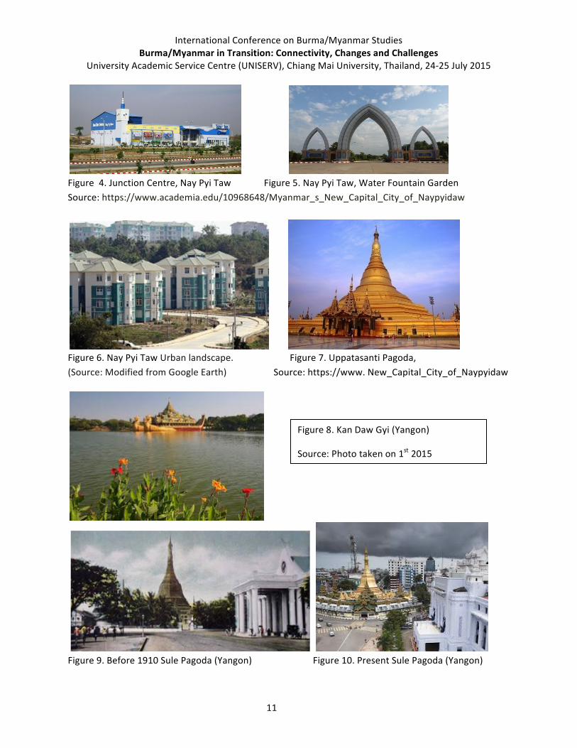
Figure 4. Junction Centre, Nay Pyi Taw Figure 5. Nay Pyi Taw, Water Fountain Garden Source: https://www.academia.edu/10968648/Myanmar_s_New_Capital_City_of_Naypyidaw
Figure 6. Nay Pyi Taw Urban landscape. Figure 7. Uppatasanti Pagoda, (Source: Modified from Google Earth) Source: https://www. New_Capital_City_of_Naypyidaw
Figure 11. Mandalay Hotel Figure 12. Palace of Mandalay Source: http://www.google.com.mm/search?q=Mandalay+images
Figure 13. Mawlamyine urban ward Figure 14. Modern house style Source: Photo taken on 1st May 2015 Source: Photo taken on 1st May 2015 Population as Measurement of Urbanization Population is the main consideration factor of urbanization. The urban population in 2014 accounted for 54% of the total global population, up from 34% in 1960, and continues to grow. The urban population growth, in absolute numbers, is concentrated in the less developed regions of the world. It is estimated that by 2017, even in less developed countries, a majority of people will be living in urban areas. The global urban population is expected to grow approximately 1.84% per year between 2015 and 2020, 1.63% per year between 2020 and 2025, and 1.44% per year between 2025 and 2030. The total population in the 10 ASEAN countries is over 590 million in 2010, 6.9 billion of world population. South-‐East Asia is less advanced in its urbanization with its urban population having increased from 32% to 42% between 1990 and 2010. Malaysia's urban population rose from 50% to
International Conference on Burma/Myanmar Studies Burma/Myanmar in Transition: Connectivity, Changes and Challenges
University Academic Service Centre (UNISERV), Chiang Mai University, Thailand, 24-‐25 July 2015
13
72%, while that of Indonesia increased from 31% to 44%. South Asia is further behind, with its urban population only increasing from 28% to 33%. In Myanmar, the total population increased from 44.32 million in 2000 to 51.42 million in 2014. Rapid population growth and urbanization will have a dramatic effect on the increased demand for jobs, housing, energy, clean water, food, transportation infrastructure, and social services. As in Yangon population increased from 1,302,000 in 1950 to 7,355,075 in 2014, Mandalay increased from 90000 in 1957 to 6145588 in 2014 and 102777 in 1953 to 2054393 in 2014 and in Nay Pyi Taw increased to 1,158,367, 2014 from 92500 in 2005 receptively. These changes in the population’s growth and spatial distribution will present a policy challenge as it will be necessary to plan adequate services for this growing urban population. Table 4 Total population and annual growth rate of Yangon City Year Number of People Number of Increase Growth Rate% 1824 10,000 1856 46,000 36,000 4.68 1872 100,000 54,000 4.76 1881 165,000 65,000 5.66 1891 181,000 16,000 0.96 1901 248,000 67,000 3.19 1911 295,000 47,000 1.75 1921 340,000 45,000 1.41 1931 400,000 60,000 1.67 1941 500,000 100,000 2.26 1950 1,302,000 802,000 10.05 1960 1,592,000 290,000 2.01 1970 1,946,000 354,000 2.01 1980 2,378,000 432,000 2.01 1990 2,907,000 529,000 2.01 2000 3,553,000 646,000 2.01 2010 4,348,000 795,000 2.01 2014 7,355,075 3,007,075 14.02 Source: Census Department.
International Conference on Burma/Myanmar Studies Burma/Myanmar in Transition: Connectivity, Changes and Challenges
University Academic Service Centre (UNISERV), Chiang Mai University, Thailand, 24-‐25 July 2015
14
Table 3. Total population and annual growth rate of Mandalay City Year Number of People Growth Rate % 1857 90000 1891 188815 2.2 1901 183816 -‐0.3 1911 138299 -‐2.8 1921 148917 0.3 1931 147932 -‐0.1 1941 163243 1 1953 185867 1.1 1963 232571 2.3 1973 417938 6 1983 532949 2.5 1993 710027 2.9 2007 921741 1.9 2014 6145588 30.43 Table 5. Population Growth of Mawlamyine City Year Number of People Number of
International Conference on Burma/Myanmar Studies Burma/Myanmar in Transition: Connectivity, Changes and Challenges
University Academic Service Centre (UNISERV), Chiang Mai University, Thailand, 24-‐25 July 2015
15
2006 326388 10419 3.19 2014 2054393 1728005 20.19 Source: Than Mya, Mi (1972): Land Utilization of Mawlamyine District, M.A Thesis Push and Pull Factors for Urbanization in Myanmar Although Myanmar economy is primarily based on agriculture, in urbanized area more people are concentrated who are working non-‐agriculture activities. Therefore the process of urbanization caused the transformation of major economic styles and life styles of the country. Urbanization is caused by the urban population growth as people migrate from rural areas to towns in search the urban social structures or better life. Rapid urbanization processes and policies favoring urban sites and industrialization also one of the consequences of migration which take changes in urban landscape. The factor that creates urbanization in Myanmar is varying one city to another. In Nay Pyi Taw the urban process is totally relying on government planning that differentiate other cities. There are many functions in Yangon and Mandalay because of its location seaports and international air line local jog opportunities as industrial zone. In Mawlamyine, there are many processes to urbanize in which transportation is the vital role. There are international trade functions are more significant. People are move to the city because they are pushed by poverty from rural societies or they may be pulled by the attractions of city lives. Combination of these push and pull factors can also be on reason for moving to cities. In Myanmar rural population growth and rural economic conditions are the major problems. These circumstances make migration the only opportunity to rural people. Push factors The normal push factors to rural people are the circumstances that make their earning of living impossible, unindustrialized farming system, lack of adequate land, unequal land distribution, droughts, storms, floods, and clean water shortages. These serious disadvantages make farming, the livelihood of rural people, hard and sometimes hopeless. Lack of modern resources, firewood shortages, religious conflicts, local economic declines, are also major reasons for moving to the urban areas. Pull factors High industrial wages in urban areas are one of the biggest attractions for rural people. People will continue to migrate to cities as long as they expect urban wages to exceed their current rural wages. Employment opportunities, higher incomes, access to better health care and education, are the pull factors for rural people. One of the main reasons for people to move to the urban areas is that the situation in the rural areas is very difficult. With the income level they have it is not possible to survive. In this case even the low salaries in the rural areas are more attractive than non-‐existing salaries in the rural areas.
International Conference on Burma/Myanmar Studies Burma/Myanmar in Transition: Connectivity, Changes and Challenges
University Academic Service Centre (UNISERV), Chiang Mai University, Thailand, 24-‐25 July 2015
16
Impact of Urban Landscape in Myanmar There are many positive and negative environmental impacts face the city inhabitants. As an area is urbanized the style and pattern of landscape vary from the older design. The housing style and the buildings are promoted to modern style. The urban development planner creates the facilities such as recreational centre, playground, and super markets. In which traffic jam, water shortage, scarcity of electricity, noisy, air pollution, congestion, insufficient waste water disposal system, area shortage for solid waste disposal sites. Slums and squatters settlements are replace within medium and high living standard settlements. The Land Use Change Nowadays, the rapid changes occurring in Myanmar urbanized areas especially Yangon, Mandalay and Mawlamyine results in the increase of living density. Landscape has been changed for commercial and residential purposes more. The growth of Yangon and Mandalay Cities cause more demand of land using especially in urban area. The land has been transferred to businessman or entrepreneurs who have come to the area with enormous funds. In addition, due to the land price which is expensive, it causes the use of land for a maximum return such as the reclamation of the building that blocks the natural flow of water, and then result in problem of water drainage and pollution. In the past, the above largest cities of Myanmar are not a big city. The area surrounded by agricultural communities. However, these largest cities like Nay Pyi Taw, Yangon and Mandalay later has grown with greater integration. The construction of residences, roads, and other infrastructure occurred continuously, and pushed the land price was higher than the past especially in urban area. Most of the land was sold and transferred from the local to local or international traders. In addition, the study found that the loss of agricultural lands has affected the food security for local people. Farmers who had sold their lands to the capitalist would not have their own land to do agricultural activity anymore, and it resulted in the loss of resources or sources of subsistence. The effect would not only occur to farmers, but also affected to other stakeholders such as local food buyers, local labours, and etc. By the way, the food security of people living in urban area may not depend on the agricultural land around the city only. They have more chance to access to food source in other areas. So, they do not depend much on local agricultural products. Therefore, the food insecurity of people in urban area needs to be considered by ecosystem and context in each area. In Yangon city, environmental problems related to industrial zones are primarily linked with the dramatic change of paddy fields to industrial land plots without prior detailed investigation, later to be followed by drainage and waste disposal problems. With insufficient infrastructure provision, especially electricity and difficulties of transportation and communication, many other problems developed as well. At present traffic jam is the important problem of Yangon.
International Conference on Burma/Myanmar Studies Burma/Myanmar in Transition: Connectivity, Changes and Challenges
University Academic Service Centre (UNISERV), Chiang Mai University, Thailand, 24-‐25 July 2015
17
In Mandalay, there are many social problems concerned with urbanization. The most important negative impact is cultural impact. There are many people migrates from northern Myanmar and neighboring country due to market liberalization policy. Their cultural influenced to the local people especially young people. Some of their cultural is very different to Myanmar traditional cultural. In Mawlamyine, as the urban population tends to increase, more and more environmental problems will occur like other cities such as solid wastes, air pollution, insufficient water supply, etc. The most important impact in Mawlamyine is agro-‐economy is significantly reduced due to labour shortage particularly young people. To reduce this impact, it is therefore necessary to establish the effective industries in Mawlamyine. It has a lot of natural resources such as agriculture products and fisheries products. By using these natural resources, there should be established the industries concerned. Economic and Social Change Myanmar's economy has expanded continuously since the government set up market-‐ oriented economy after 1988. It is the transportation hub of the ASEAN region which easily linked to Thai region to neighboring countries such as India and China. The economic growth of Myanmar currently is displayed by the expansion of the trade, more commercial buildings such as department store or big retail store, more labour employment. In addition, the policy from both central and local government is also a factor which pushes Yangon and Mandalay to be a center of the logistics and air transportation hub in this region. Societal issue, economic growth in Myanmar especially Yangon and Mandalay has attracted workers from rural come to work and live in the city. They mostly have worked in private company service sector such as in the restaurant, construction site, and business site including supermarket. By the way, most of them enter the city by rural-‐urban migration process. The study found there is lifestyle or cultural changes. Another issue is health problem the entry of foreign workers or local people to go out for higher income may bring some unknown diseases, some diseases which spread from neighboring countries through labor migration. Road and traffic problems Traffic condition in Yangon and Mandalay is problematic especially in the morning and evening which are the time that many people who live outside municipality area are traveling to work and study in urban area. It causes many vehicles on the road, and then causes the traffic jam. Traffic jam problem is not only happening in the downtown area, but it also happens in the suburbs area especially industrial zones where is full of a suburban residential area. However, the relevant authorities have tried to solve the problem such as constructing more roads or abutments to resolve traffic problems in the bypass road.
International Conference on Burma/Myanmar Studies Burma/Myanmar in Transition: Connectivity, Changes and Challenges
University Academic Service Centre (UNISERV), Chiang Mai University, Thailand, 24-‐25 July 2015
18
Waste disposal problem The study found that there were complaints about the garbage truck from those who live along the road. In addition, people who live in nearby area have to endure with the smell of garbage. The study also concern about the waste disposal system in the business sector especially in the major-‐size entrepreneurs. Currently the study found that waste disposal system has been installed in some businesses only. Most of businesses still use the services from the local municipality to remove the waste and do the waste disposal. Big business is groups produced lots of garbage each day, but the agencies that manage the waste disposal still limit, and affect the smell pollution to urban area. The industry as well, each day the waste is numerous produced, and the waste in the factory mostly were electronic waste or waste from industrial activity which is very dangerous to environment. These wastes are currently being forwarded to large industrial waste disposal systems in other province. However, electronics waste was produced a lot, so the plant is unable to load and forward the waste to disposal area. It would be necessary to find out a place for store the waste to await the waste transportation to the disposal area. Sustainable Urban Landscape in Myanmar Sustainable development is often presented as having three dimensions: economic, social and environmental. Urbanization provides opportunities for achieving progress along all these dimensions, but the opportunities need to be seized. Preventing people from coming to cities tends to be economically, socially and environmentally damaging, but successful urbanization is achieved and not simply allowed. Urbanization in Myanmar during the first decade of the 2000s lagged behind that of its neighbors, likely as a result of Myanmar’s economic isolation, which continued until about 2010. Myanmar urban population in 2014 is 28.89% of total population and rate of urbanization is 2.49% annual rate of change (2010-‐15 est.) Yangon is Myanmar’s largest urban area. However, spatially it barely grew during this period, expanding at a rate of 0.5% a year between 2000 and 2010, from 370 square kilometers to 390. Urbanization has always raised environmental concerns. Large parts of cities consist of resettlement areas, reflecting the relocation and housing programs for government staff in the 1960s and early 1990s in Mandalay. These areas have urban services much below acceptable levels. Inadequate water, drainage, and sanitation services, combined with insufficient preventive health care, have resulted in severe health threats at many levels. As in Nay Pyi Taw drainage system is required for local people to safety living. If maintains its rapid development, this will continue to have a positive effect on urban infrastructure insufficient and slums. Long term solutions is effective action by governments especially at the local level, is necessary to implement the necessary urban planning, and to provide infrastructure and services.
International Conference on Burma/Myanmar Studies Burma/Myanmar in Transition: Connectivity, Changes and Challenges
University Academic Service Centre (UNISERV), Chiang Mai University, Thailand, 24-‐25 July 2015
19
Conclusion and Discussion These fast growing social, economic and ecological problems are very challenging for stakeholders, who involve in the urban development, in developing country as Myanmar. Systematic cities do not occur by chance, but are achieved associated with clearly development guidelines which are generated by cooperation between government agencies, local people and urban planner. The ways to accomplish creation of sustainable city including the need of local people, the need which is based on resource allocation, reviewing existing development guidelines, development of integrated infrastructure. In addition, encouragement of private sector participation (PSP) is essential to develop the city. The planning process should focus on requirements of people in developing the city in the next 10 to 15 years. Both private and public sectors should have the cooperation to develop the city. In addition, resource allocation should be focused on to construct the rapid growth city sustainably, or enable the private sector to address other infrastructure challenges. Collaboration between the government and private sector is also necessary to advise the city to keep on track in the planning.
This will affect to various aspects including economics, socials and environments, and also effected to other ASEAN countries. This is very essential to study all big impacts and changes in urban landscape in Myanmar.
International Conference on Burma/Myanmar Studies Burma/Myanmar in Transition: Connectivity, Changes and Challenges
University Academic Service Centre (UNISERV), Chiang Mai University, Thailand, 24-‐25 July 2015
20
References Frauke Kraas, Hartmut Gaese, Mi Mi Kyi (eds.), (2005): Megacity Yangon: Transformation processes and
Modern development, Second German-‐Myanmar Workshop in Yangon/Myanmar 2005. (Southeast Asian Modernities, vol 7)
Tin Moe Lwin, Mg (2010): Urban Development and spatial structural changes after the 1988 economic liberalization in Mandalay, Myanmar’s second largest city, PhD, Dissertation, Graduate School of Science, Tohoku University.
Aye Aye Lwin, Tin Tin Maw, Nilar Win (2008): Preliminary Study of Environmental Factors Controlling the Urban Areas In Mawlamyine City, Research Paper, Department of Geography, and University of Mawlamyine.
Gordon McGranahan and David Satterthwaite, (2014): Urbanization concepts and trends, working paper.
Department of Human Settlements & Housing Development Ministry of Construction October, 2014: Japan-‐OECD Policy Forum on Urban Development and Green Growth.