Page 1
Louisiana State UniversityLSU Digital Commons
LSU Historical Dissertations and Theses Graduate School
1987
Parameters of Peat Formation in the MississippiDelta (Holocene).Elisabeth Catharina KostersLouisiana State University and Agricultural & Mechanical College
Follow this and additional works at: https://digitalcommons.lsu.edu/gradschool_disstheses
This Dissertation is brought to you for free and open access by the Graduate School at LSU Digital Commons. It has been accepted for inclusion inLSU Historical Dissertations and Theses by an authorized administrator of LSU Digital Commons. For more information, please [email protected] .
Recommended CitationKosters, Elisabeth Catharina, "Parameters of Peat Formation in the Mississippi Delta (Holocene)." (1987). LSU Historical Dissertationsand Theses. 4366.https://digitalcommons.lsu.edu/gradschool_disstheses/4366
Page 2
INFORMATION TO USERS
While the most advanced technology has been used to photograph and reproduce this manuscript, the quality of the reproduction is heavily dependent upon the quality of the material submitted. For example:
• Manuscript pages may have indistinct print. In such cases, the best available copy has been filmed.
• Manuscripts may not always be complete. In such cases, a note will indicate that it is not possible to obtain missing pages.
• Copyrighted material may have been removed from the manuscript. In such cases, a note will indicate the deletion.
Oversize materials (e.g., maps, drawings, and charts) are photographed by sectioning the original, beginning at the upper left-hand corner and continuing from left to right in equal sections with small overlaps. Each oversize page is also filmed as one exposure and is available, for an additional charge, as a standard 35mm slide or as a 17"x 23" black and white photographic print.
Most photographs reproduce acceptably on positive microfilm or microfiche but lack the clarity on xerographic copies made from the microfilm. For an additional charge, 35mm slides of 6"x 9" black and white photographic prints are available for any photographs or illustrations that cannot be reproduced satisfactorily by xerography.
Page 4
Order Number 8719874
Parameters of peat formation in the Mississippi Delta
Rosters, Elisabeth Catharina, Ph.D.
The Louisiana State University and Agricultural and Mechanical Col., 1987
U M I 300 N. Zeeb Rd. Ann Arbor, MI 48106
Page 6
PLEASE NOTE:
In all cases this material has been filmed in the best possible way from the available copy. Problems encountered with this document have been identified here with a check mark V .
1. Glossy photographs or pages
2. Colored illustrations, paper or print
3. Photographs with dark background
4. Illustrations are poor copy
5. Pages with black marks, not original copy
6. Print shows through as there is text on both sides of page
7. Indistinct, broken or small print on several pages
8. Print exceeds margin requirements
9. Tightly bound copy with print lost in spine
10. Computer printout pages with indistinct print
11. Page(s) lacking when material received, and not available from school or author.
12. Page(s) seem to be missing in numbering only as text follows.
13. Two pages numbered . Text follows.
14. Curling and wrinkled pages
15. Dissertation contains pages with print at a slant, filmed as received
16. Other
University Microfilms
International
Page 8
PARAMETERS OF PEAT FORMATION IN THE MISSISSIPPI DELTA
A DISSERTATION _
SUBMITTED TO THE GRADUATE FACULTY OF THE LOUISIANA STATE UNIVERSITY AND
AGRICULTURAL AND MECHANICAL COLLEGE IN PARTIAL FULFILLMENT OF THE
REQUIREMENTS FOR THE DEGREE OF DOCTOR OF PHILOSOPHY
IN
THE DEPARTMENT OF MARINE SCIENCES
BY
ELISABETH CATHARINA ROSTERS
B.S., UNIVERSITY OF GRONINGEN, THE NETHERLANDS, 1975 M.S., UNIVERSITY OF AMSTERDAM, THE NETHERLANDS, 1982
May 1987
Page 9
DEDICATION
This dissertation is dedicated to: Rob, Mara, Vader, Moeder,
Nettie and Wim.
"I think I remember what Kant said: "understanding without observation is empty, but observation without understanding is dead". As long as one does not give names, one cannot observe what one sees. Maybe this is what makes our science so fascinating: one learns - a bit - to observe, and that is just about the most difficult thing to do"
Maarten 't Hart (Dutch ethologist and writer): "De Waterstaafwants"
Page 10
ACKNOWLEDGEMENTS
This study was funded by:
1) the U.S. Dept. of Energy, contract #
DE-FY18-21FE05113,
2) the State of Louisiana, Dept. of Natural Resources,
Louisiana Geological Survey, Unified Geological
Investigation, contract #214-00-82-14,
3) the State of Louisiana, Dept. of Natural Resources,
Louisiana Geological Survey, Barataria Basin
Assessment, contract # 137-15-4122 and
4) the Center for Energy Studies, Louisiana State
University, grant #84-02-15.
Laboratory space and equipment was provided by Dr. Dag
Nummedal of the Dept. of Geology, Dr. Frank Iddings of the
Dep. of Nuclear Science, and Drs. Harry Roberts and James
Coleman of the Coastal Studies Institute. Laboratory and
computer work for the moisture and organic matter
determinations was carried out by Peggy Rooney, Hi-Il Yi and
Kelley Templet-Wallace. 14C dates were provided by the
Louisiana Geological Survey's Radiocarbon Laboratory and by
Krueger Enterprises, Inc., Cambridge, Mass. Dr. Arthur D.
Cohen (Los Alamos National Laboratory) prepared and analyzed
19 paraffin-mounted microtome sections from vibracore
subsamples. Cartographic support was provided by Louisiana
Geological Survey cartographers Edwin Millet, William
Fournerat, Marie Judice, Carol Terry, Dorothy Blades, Chris
i i i
Page 11
Romaine, Ed Babin, Rueben Solar, and Karen Westphal. Karen
Ramsey was a great help in preparing the final versions of
the manuscript. I thank Louisiana Geological Survey
Director Dr. Charles Groat for allowing this material to be
used for dissertation and Dr. Don Bebout, presently with the
Bureau of Economic Geology, for originally trusting me with
the project. Of all field assistants, I would especially
like to thank Paul Templet for spending many long hot days
collecting all the vibracores. The database would not have
existed without his help. I thank my advisor, Dr. Harry
Roberts for encouraging me to work towards a Ph.D. and for
his careful and thorough scrutiny of the work and the
ensuing manuscript. Many discussions with Dr. Jim Coleman
made me aware of the true nature of Mississippi Delta
geology and contributed much to the work here presented.
Alan Bailey of the University of Southwestern Louisiana has
been a faithful colleague and friend and served as a first
and patient listener to most of the ideas presented here.
In the meantime, he taught me about geochemistry. If I
learned anything about vegetation and plant-soil
interactions, it is due to my dear friend Gail Chmura of the
Laboratory for Wetland Soils and Sediments, who made me
truly love the marshes and thoroughly edited the manuscript.
I thank my colleague and friend John Suter and Shea Penland
for being there during all these years and my other
colleagues at the Coastal Geology Program for cheers and
encouragement.
i v
Page 12
Lastly, I want to express gratefulness to my family: to my
husband Rob for taking more than his share of parenting Mara
and bearing through what must have been an ordeal for him;
to my parents for giving me a liberal education, allowing me
to study whatever I desired and always supporting me; and to
Rob's parents Nettie and Wim for endlessly babysitting Mara,
providing a home-away-from-home, and for their unfailing
encouragement.
v
Page 13
TABLE OF CONTENTS
Title Page i Front Page ii Acknowledgements iii Table of Contents vi List of Tables vii List of Figures viii List of Appendices xxiii ABSTRACT 1 INTRODUCTION AND OBJECTIVES 4 BACKGROUND 9
Origin of peat 9 Deltaic peats and coals 11
METHODS 15 Collection of cores and augers 15 Laboratory techniques . 16 Sediment identification and terminology ...... 18
GEOLOGIC SETTING . . . . 19 Regional setting of the Mississippi Delta 19 Depositional environments of Mississippi Delta peats 19 Floating marshes 21
GUEYDAN AREA 24 AVERY ISLAND AREA 32 LAKE PONTCHARTRAIN AREA 37 BARATARIA BASIN 41
The term interdistributary basin 41 Physiography 43 Lithostratigraphic units 46 Stratigraphy . . . . 75 Development of Barataria Basin 78
ANALYTICAL RESULTS 97 Distribution of organic matter . 97 Quantities of various types of organic sediments . 98 Implications for modern coal-forming environments . 112 Accretion rates, compaction, submergence 113
DISCUSSION 126 CONCLUSIONS 129 REFERENCES 132 APPENDIX 151 VITA 255
vi
Page 14
LIST OF TABLES.
Page
Table I Average properties of peats for different 104
study areas. Note closeness of average
organic matter content for each area. The
distribution curve of mean organic matter
content of peats is shown in Figure 32.
Table II Percent surface area of the 4 organic-sediment 110
types in Barataria Basin as determined by
planimetering contoured cross-sections (Figs.
33 and 34).
Table III Correlation matrix for occurrence of different 111
types of organic material (Figs. 33 and 34).
v i i
Page 15
LIST OF FIGURES
Page
Figure 1 Location of study areas and Holocene 8
Mississippi deltaic complexes (after
Frazier, 1967).
Figure 2 Gueydan: channel-fill deposit in 27
Latanier Bayou. Upper part of
figure shows stratigraphic cross
section, where histograms along
cores illustrate percent organic
matter in the samples. Lower part
of figure shows isopleth map of
Latanier Bayou after Engineering
Bureau Shutt and Sons (in Kress,
1980), and location of cross
section.
Figure 3 Gueydan: channel-fill deposit at 29
Latanier Bayou. Central portion of
Latanier Bayou (Fig. 2, location)
with isopach of organic deposits
containing more than 25% organic
matter.
vi i i
Page 16
Figure 4 Gueydan: channel-fill deposit at Latanier 31
Bayou. X-ray radiograph of organic-rich
material at 350 - 375. cm depth in core G13
(Fig. 2, location). The lithology is
identical to that in core G3, 300 - 400 cm
depth. Radiograph shows characteristic finely
bedded structure of lower portion of a
channel-fill floating marsh.
Figure 5 Avery Island blanket peat deposit. 35
Figure shows location of 9 cores and
3 stratigraphic sections.
Dip-section B-B' is also shown. The
dip-section displays two peat beds
of swamp origin, incorporated in
organic-rich woody swamp material,
overlain by a landward thinning
wedge of post delta lobe abandonment
organic-poor saline marsh deposits.
Figure 6 X-ray radiograph of peat (lithologic 36
unit), in AI 1, 125 - 150 cm depth.
Original was 25 cm long, 7 cm wide.
In these fresh water swamp peats,
presently inundated by salt water,
most roots have remained
diagenetical1y unaltered, but many
i x
Page 17
Figure 7
Figure 8
Figure 9
Figure 10
Figure 11
Figure 12
clusters of white, diagenetic
features can be observed. Most of
these features prove to be pyrite.
Lake Pontchartrain area: location of 39
auger holes organic matter content
of samples.
Lake Pontchartrain area: organic matter 40
content of samples.
Different features of small- and large-scale 42
interdistributary basins, dominated by
regressive and aggradaiional processes
Physiography of Barataria Basin. 45
Vegetation zones after Chabreck and
Linscombe (1978).
Location of cores and cross sections 47
in upper Barataria Basin.
Location of cores and cross sections 48
in lower Barataria Basin.
X
Page 18
Figure 13 Legend for stratigraphic cross
sections (Figs. 14, 15, 16, 19, 20,
27, and 28) .
Figure 14 Barataria Basin - Stratigraphic
cross section H-H' (for location and
legend see Figs. 11 and 13).'Note
that peat beds are continuous and
that almost all peats are located
directly on top of the abandonment
phase.
Figure 15 Barataria Basin - Stratigraphic
cross section J-J' (location and
legend, Figs. 11 and
13). Shallowness of the depression
is partially the result of coring
close to basin drainage channel in
BB 82, 81, 80, 84, and 83.
Situation under Lac des Allemands
uncertain (question mark).
Figure 16 Barataria Basin - Stratigraphic
strike section G-G' (for location
and legend see Figs. 12 and 13).
Encroachment of salt marsh shows as
organic-poor top horizon in
Xi
Page 19
westernmost portion of section
(cf. core 69 and 68). Peats are only
present in the far western end of
the section, close to the Lafourche
distributary system.
Figure 17 X-ray radiograph of basin-fill
(lithologic unit B) in BB 87,
350-375 cm depth. Original is 25 cm
long, 7 cm wide. Inclination of
beds along edges is due to coring
disturbances. Lighter horizons are
denser and contain sandy silt,
darker ones are clayey and contain
organic material. Note sharp
bottoms of coarser beds and
incorporated organics. Siderite
horizon (indistinct white area)
visible in lower portion of
radiograph. Most bedding in this
unit is parallel, and normally
graded units shown here are common.
Figure 18 X-ray radiograph of top of
basin-fill (lithologic unit B) in
core BB 71, 200-225 cm depth.
Original was 25 cm long, 7 cm wide.
x i i
Page 20
Triangular piece on right-hand side
is somewhat decomposed piece of
cypress wood. Note difference in
rooting density above and below wood
and rooting continuing through wood.
Figure 19 Barataria Basin - Stratigraphic 64
dip-section C-C' (location and
legend Figs. 12 and 13). This
section is shown to illustrate
extensive presence of incipient
marshes (lithologic unit E-l
Figure 20 Barataria Basin - Stratigraphic 6 6
dip-section A-A' (location and
legend, Figs. 12 and 13). Three
different organic-rich phases can be
correlated laterally. Comparing
stratigraphy with cross section B-B'
(Fig. 28) (using cores BB 33, 14,
17, 47, 60, 65 and 43), cross sec
tion A-A' and B-B' correlate with
each other.
Figure 21 X-ray radiograph of abandonment
phase (lithologic unit D), in BB 58,
x i i i
6 7
Page 21
100-125 cm depth (see Appendix for
core log). Original is 25 cm long,
7 cm wide. Dark contact at top
represents clay—peat contact. Note
that clays are completely massive
and featureless, except for evidence
of plants. Note also that roots
show up both white (diagenetically
altered) and black (oxidized). Much
of this diagenetic alteration
appears to consist of pyrite.
Figure 22 X-ray radiograph of organic-poor 81
material (lithologic unit) in BB 58,
75-100 cm depth. Original is 25 cm
long, 7 cm wide. Root density and
diagenetic features are moderately
abundant. Some roots are
diagenetically altered, most likely
by pyrite.
Figure 23 X-ray radiograph of organic-poor 83
material (lithologic unit) in BB 62,
26-44 cm depth. Original is 25 cm
long, 7 cm wide. Root density
decreases towards top (organic-rich
x i v
Page 22
unit) but is high in organic-poor
unit. Very little diagenetic
alteration can be observed,
indicating that conditions did not
become extremely anaerobic. Most
diagenetic alteration can be
observed as small dots, not as root
replacements. Clay lens in central
portion is associated with marsh
drowning event of Figure 30-D/E (cf.
F i g . 2 2 ) .
Figure 24 Hypothetical cycle of vertical marsh
accretion, decomposition and
subsurface organic matter
preservation in the Mississippi
Delta Plain.
Figure 25 X-ray radiograph of organic-rich
material (lithologic unit) in core
BB 87, 50-75 cm depth. Original was
25 cm long, 7 cm wide. Whitish
flakes are aluminum from core bar
rel. Note near absence of roots and
diagenetic features, and abundance
of freshwater sponge spicules just
below center. This rootless bed of
Page 23
organic-rich material may have been
associated with a floating marsh.
Figure 26
Figure 27
X-ray radiograph of peat (lithologic
unit) and overlying silty sandy lens
in BB 36, 75-100 cm depth. Original
was 25 cm long, 7 cm wide. Note
rip-up of peat into overlying silt
and rootlessness of peat overall.
Some fresh water sponge spicules can
be seen in bottom of picture. Very
thin clay lenses in peat may have
been deposited by flocculation after
slight change in pH of water, for
example after passage of major storm.
Barataria Basin - Stratigraphic
strike-section F-F' (for location
and legend see Figs. 12 and 13).
Note that more peat is present in
the western basin than in the
eastern basin, and that the upper
organic-poor phase contains detrital
clastics in BB 36 and 27.
Figure 28 Barataria Basin
dip-section B-B'
- Stratigraphic
(location and
Page 24
legend, Figs. 12 and 13). Note more
erratic appearance of organic fill
in this section than in cross
section A-A' (Fig. 20).
Figure 29 Chronology of Mississippi Deltaic 93
Complexes (after Frazier, 1967) and
major sedimentary events in
Barataria Basin, based on the
stratigraphy and on 14C dates of
whole, hinged Rangea cuneata shells,
in-situ peat horizons (Fig. 30
Paleogeographic reconstruction).
Figure 30 Paleogeographic reconstruction of 95
Barataria Basin based on data from
Frazier (1967) and from this study.
A - 4000 yrs BP. Barataria Basin is
a large open bay, between the
Maringouin/Teche and early St.
Bernard delta complexes. Rangea
cuneata thrives in this bay.
B - 3000 yrs BP. lobes #6 and #7
(Bayou des Families) are dominant.
Barataria Basin is filled by over-
bank sediments. Peat phase A locally
developed.
x v i i
Page 25
C - 2000 yrs BP. Lobes 6 and 7 have
been abandoned and an ideal
sheltered peat-forming environment
exists (organic-rich and peat phase
B).
D - 1000 yrs BP. Sedimentation from
the Lafourche complex causes
increased detrital influx in
Barataria Basin, more or less
terminating organic-rich phase B.
E - 800 yrs BP. Peat swamps are
everywhere blanketed by clastic
sediment, but this is locally
absent.
F - 400 yrs BP. Clastic deltaic
sedimentation has bypassed the area
and renewed peat accumulation starts
(phase C).
Figure 31 Histogram showing the frequency of occurrence 102
of the organic matter contents (in 5% ranges)
of 789 samples, taken from all study areas.
Natural breaks in the histogram are either
nonexistent or statistically insignificant.
Figure 32 Distribution
peat samples
curve of the quality of
in all areas. Vertical
x v i i i
103
Page 26
Figure 33
Figure 34
Figure 35
axis: ranges of organic matter
content; horizontal axis: %
frequency of occurrence.
Barataria Basin: contoured 105
dip-section B-B'. Contour lines were
drawn at 10% organic matter inter
vals. The surface area of each of
four ranges was calculated using a
digital planimeter (Fig. 34).
Barataria Basin: histograms showing 107
the proportion of surface areas of
the four ranges of organic matter as
determined from 8 planimeter cross-
sections. Vertical axes: %
occurrence; horizontal axes: organic
matter content (four ranges: 0-10%;
10-30%; 30-70%; 70-100%).
Linear regression and correlation 108
between surface areas of
organic-poor material and detrital
sediments, respectively (Y-axis) and
organic-rich material (X-axis). With
increasing amounts of organic-rich
material, quantities of detrital
x i x
Page 27
sediments and organic-poor material
decrease (r=-0.69 and r=-0.76,
respect ively).
Figure 36 Linear regression and correlation 109
between surface areas of
organic-poor and organic-rich
material, respectively (Y-axis) and
peat (X-axis). With increasing
amounts of peat, organic-rich
material decreases (r=-0.85) and
organic-poor material increases (r=0.75).
Figure 37 Relationships between bulk density 120
and depth. At left: relationship
between bulk density (g/cm3) and
depth (cm) for the top 80 cm of
section. Regression line: y =
-437.27x + 1.72 with r = 0.50. At
right: relationship between bulk
density (g/cm3) and depth (cm) for
the total section. Mean bulk
density for samples taken at depths
less than 1 m is 0.11 g/cm3, for
samples taken from 1-3 m is 0.13
g/cm3, and for samples at depth more
than 3 m is 0.15 g/cm3.
XX
Page 28
Figure 38 Log-linear relationships between 121
percentage organic matter and
percentage moisture. Number of
samples = 153. The upper regression
line is for samples taken at depths
less than 1 m: y = 9.67 lnx + 47.97,
with r2 = 0.42. The middle
regression line is for samples taken
at depths 1 - 3 m: y = 10.32 lnx +
44.24, with r2 = 0.64. The lower
regression line is for samples taken
at depths greater than 3 m: y =
8.47 lnx + 50.49, with r2 = 0.50.
For 81.3% organic matter, the
average peat quality in South Loui
siana, compaction is 2.8% in the top
4 m of section.
Figure 39 Linear regressions for 14C dates 123
against depth for samples from peat
phase B in Barataria Basin. Area 1:
Lac des Allemands to Des Allemands
(cross section J-J'); Area 2: Des
Allemands to Lake Salvador (cross
section H-H'); Area 3: Lake Salvador
to Little Lake. Thick line
x x i
Page 29
represents compiled regression for
all areas. Dot in circle on
regression for area 3 represents t
data points.
x x i i
Page 30
LIST OF APPENDICES
Appendix: Core Legend and Graphic logs of cores BB 1-95 and
cores AI 1-9.
x x i i i
Page 31
ABSTRACT
The Mississippi Delta is located in a subtropical and
moderately humid climate. Six major Holocene deltaic
complexes developed, each with a life span of about 1500
years (Coleman and Gagliano, 1964; Frazier, 1967; Kolb and
Van Lopik, 1958). Peats accumulate over abandoned delta
lobes, in large-scale interdistributary basins, in abandoned
channels, and as detrital peats nearshore. This
dissertation discusses the first three types.
Emphasis is on Barataria Basin, a large-scale
interdistributary basin, located between levees of the
Lafourche and St. Bernard/Plaquemine delta complexes. A
characteristic 6 m thick set of lithostratigraphic units
constitutes basin-fill sediments. These units are: open
bay, restricted basin, each blanketed by massive organic
muds (abandonment phases), natural levee, basin drainage
channel, lacustrine sediments, crevasses, and organic
sediments, ranging from various types of organic-poor beds
to organic-rich beds and peats. Organic-rich beds occur in
three phases, each representing an accumulating period that
was interrupted by subsidence and the influx of detrital
clastics from renewed nearby fluvio-deltaic sedimentation.
1
Page 32
2
Peats of the Mississippi Delta Plain accumulate in
eutrophic, non-domed1 environments in fresh water swamps and
(often floating) marshes. Peats average 81.7% organic
matter. They occur in the same stratigraphic unit as
organic-rich beds and are predominately situated on top of
clays and organic-poor sediment. In central Barataria
Basin, peat beds are laterally discontinuous, contrasting
with more continuous ones in the upper basin. This
difference reflects greater subsidence and overbank flooding
in the lower Basin compared to the upper basin. In the
upper Basin, accumulation rates balanced with subsidence,
whereas in the lower Basin, subsidence rates were higher,
creating a depression that was prone to be flooded.
Quantities of organic-rich material and peat are inversely
related. In addition, quantities of peat and organic-poor
material are inversely related. This latter correlation
indicates either one of two possible settings:
1) more peat accumulated on top of organic-poor material,
because organic-poor beds provided a base for plant
growth and a supply of nutrients;
2) organic-poor material accumulated preferentially on top
of peat because peat-accumulating areas eventually form
topographic lows that were more likely to become
flooded.
1 Cecil et al. (1985) distinguish eutrophic, non-domed (or planar) peats and domed (raised) oliogotrophic peats.
Page 33
3
Relatively low mean organic matter content of peats in the
Mississippi Delta is influenced by botanical parent material
and short-term detrital clastic influx. Thickness and
lateral continuity are restricted by subsidence and
accretion, marine inundation and long-term effects of
detrital clastic influx.
Page 34
INTRODUCTION AND OBJECTIVES
Peat beds are important sedimentary deposits, because they
represent a modern analogue of coal-forming environments and
provide clues for reconstruction of geochronology. Peat has
received little attention in literature dealing with deltaic
environments. Most existing deltaic peat literature focuses
on broad regional aspects of peat stratigraphy (Fisk, 1960;
Coleman and Smith, 1964; Frazier, 1967; Frazier and Osanik,
1969) or on paleobotanical aspects and maceral types (Styan
and Bustin, 1983, 1984; Cohen, 1973, 1974). Peat deposits
of the Mississippi Delta were long considered prime examples
of modern coal-forming environments (Wanless et al., 1963;
Elliott, 1974b; Baganz et al., 1975; Home et al., 1978;
Ryer, 1981, Tewalt et al., 1981), although it had been shown
that they contained very high ash percentages (Fisk, 1960;
Frazier and Osanik, 1969). In addition, peaty (deltaic)
deposits have experimentally been shown to be effective
petroleum sources if reservoir development occurs
geologically early (Rohrback et al., 1984; Risk and Rhodes,
1985, Shanmugan, 1985).
When studying deposits of modern environments, it is
important to address fundamental questions regarding the
relationships between sediments ' and the rock record. In the
context of this study, the Mississippi Delta is evaluated
4
Page 35
5
an example of a modern coal-forming environment. Questions
are
1) Can we explain the present situation?
2) Can we favorably compare the geometry of the delta lobes,
their regional stratigraphy and local variation, the
quality and quantity variations of the peats and
associated deltaic strata to similar environments in
the rock record?
3) If we do indeed see modern analogues of coal-forming
environments in the Mississippi Delta, are these
deposits likely to become preserved?
A problem one deals with when working in this area, is the
historic aspect of research in the Mississippi Delta, one of
the best studied in the world. The advantages of working in
it are obvious: the literature has provided us with a well-
constructed framework on which further studies can be
anchored. However, there are disadvantages. The
extrapolation of modern knowledge of the delta to the rock
record is sometimes unclear. Literature dealing with the
interpretation of depositional environments of coal often
quotes Fisk's (1960) and Frazier's (1967) papers, without
addressing the limitations of such comparisons. Also, such
articles often compare ancient deposits to those of the
modern Balize Delta (Elliott, 1974b, 1975). However, the
Holocene deltas that constituted the deltaic plain reach
maximum thicknesses of only about 20m, whereas the modern
Page 36
6
Balize delta is up to 200 m thick (Coleman, 1981).
Consequently, there are two types of environments that do
not occur in the Balize delta: (1) abandoned deltas -
(slowly) subsiding lobes upon which vegetation has
developed, and (2) (large-scale) interdistributary basins
(Coleman and Smith, 1964).
In many studies of deltaic lignites and coals (Kaiser, 1974,
1978; Kaiser «t al., 1980; Home et al., 1978; Flores, 1979)
the authors have noted that the thickest coals are situated
in close vicinity to clastic sediments that deposited more
or less contemporaneously with peat formation. This
situation is in contrast with the one proposed by Cecil et
al. (1985), who suggested that a raised (ombrogenous) bog
with complete absence of detrital clastic influx is required
for low-ash peat accumulation. In addition, occurrences of
thick coal seams in close proximity to detrital clastic
sediments seems to contradict ideas put forward by many
authors (Home et al, 1978; Fisk, 1960; Frazier and Osanik,
1969) that high-quality peat forms in the center of basins
away from detrital influx.
Researchers working in both ancient and modern sediments
have so far not focused their investigations on quantified
estimates of organic matter contents and detailed
sedimentology simultaneously. Such information is needed to
evaluate the potential of these deposits as coal precursors
Page 37
and to develop predictive models of coal formation. Thus,
it is the objective of this study to provide a data base fo
evaluating quality, quantity, and lithofacies relationships
of peats within the Holocene Mississippi Delta complex. In
addition, I hope to create a framework from which
comparisons to the rock record - with respect to deltaic
coal-forming environments - can be properly made.
The four areas studied were: Gueydan, Avery Island, Lake
Pontchartrain and Barataria Basin (Fig. 1). Research in
Barataria Basin provides most of the data for this
investigation. The three smaller areas, Gueydan (channel-
fill peat), Avery Island (blanket peat), and Lake
Pontchartrain (marginal deltaic plain) provided additional
insight into peat formation.
The data base in all areas was formed by a collection of
7.5-cm-diameter vibracores, which were visually logged and
occasionally analyzed using X-Ray radiography. In addition
lithology, degree of peat decomposition and broad botanical
constituents were also noted. In analyzing X-ray
radiographs, rooting and diagenetic features in peats and
other organic beds were emphasized. A total of 789 samples
was analyzed for both moisture and organic matter content.
Page 38
8
Orlea
80 mi 1
1 Gueydan 2 Avery Island 3 Barataria Basin 4 Lake Pontchartrain
Maringouin Delta Complex Teche Delta Complex St. Bernard Delta Complex Lafourche Delta Complex Plaquemine Modern Delta Complex
Pleistocene Outcrop
Figure 1 Location of study areas and Holocene
Mississippi deltaic complexes (after
Frazier, 1967).
Page 39
BACKGROUND
Origin of peat
Peat is the accumulated remains of dead plants (Clymo, 1983)
and - in this definition - can be of any botanical origin
and any ash content2. Slightly more specific is the
definition by ASTM (1969) (see p. 19 beds). Peat can be
autochthonous (in-situ) or allochthonous (detrital). The
latter is thought to be rarer in occurrence than the former
(Galloway and Hobday, 1983), and was not a topic of
invest igat ion.
Autochthonous peat originates when dead plant matter
accumulates below the water surface and undergoes physical
and chemical changes (Clymo, 1983). It is as yet
undetermined how much of the total mass of peat consists of
either above- or below-ground biomass (shoot/root ratios,
see Raymond, 1986). The physical and chemical changes are:
1) loss of organic matter,
2) loss of physical structure,
3) change of chemical state.
2This section is not intended as a treatise on terminology. Because peat is studied by botanists, geologists, and soil scientist, the problem of definition is vast and largely semantic. For literature on the subject, see Etherington (1983), Moore and Bellamy (1974), Soil Conservation Service (1971), Farnham and Finney (1965), Dawson (1956), Cowardin et al., (1979), Penfound (1952), Hofstetter, (1983).
9
Page 40
10
Plant material consists of organic and inorganic
constituents, the latter constituting 1-13% of the total
tissue (Alexander, 1977). Organic constituents are
cellulose and hemicellulose, lignin, water-soluble and
ether-soluble components, and proteins. The bulk of plant
matter is composed of cellulose, hemicellulose and lignin,
with the latter being most dominant in wood (Alexander,
1977).
After death of the plant, microbiological processes cause
decomposition of organic matter, with lignin decomposing at
the slowest rate and large particles decomposing at a slower
rate than small particles. In peat-forming environments
like marshes and swamps3, plant matter accumulates below the
water table, where aerobic decomposition slows due to lack
of oxygen and organic material may become preserved as peat.
Peat - as a sediment - can then be described according to a
number of physical properties,.the most important of which
are: botanical composition, state of decomposition, bulk
density, moisture content, organic matter content (ash
content), and heat of combustion (Clymo, 1983). In
addition, peat can be identified by its geologic setting
(raised bog, back-barrier, deltaic, etc.). Invariably, the
physical characteristics of peat will show a relationship
3Penfound (1952) first distinguished "forested swamps" and "herbaceous marshes"..
Page 41
with the geologic origin, as suggested by Cecil et al.
(1985). There are two environmental nutrient-related
categories: eutrophic or oligotrophic. Eutrophic systems
receive influx from nutrient-rich drainage waters (almost
invariably laden with suspended sediment), whereas
oligotrophic systems receive only nutrient-poor
precipitation and consequently contain ombrotrophic bogs,
usually with large amounts of mosses (Sphagnum spp).
Peats of the Mississippi Delta are eutrophic in origin.
Even on abandoned delta lobes or in the central portions of
large-scale interdistributary basins, runoff waters flow
through peat accumulation areas, either after storms or
after riverine floods. Thus, the inorganic component of peat
may consist of authigenic silica (plant silica), biogenic
silica (fresh-water sponge spicules), detrital silicates
(clay), early diagenetic minerals (e.g. pyrite) and water-
soluble salts (Brupbacher et al., 1973; Kosters and Bailey,
1983, 1986; Bailey and Kosters, 1983). Sphagnum is
essentially absent (Hofstetter, 1983).
Deltaic peats and coals.
Most coal researchers, with exception of Cecil et al.
(1985), were influenced by studies in the Mississippi Delta
when interpreting the rock record. While previous studies
in the modern Mississippi Delta provided an excellent basis
Page 42
12
for understanding the regional stratigraphy of organic-rich
deposits, little was known about the quantity, quality, and
internal variation of the deltaic peat beds with respect to
their different depositional settings in the delta plain.
Recently, McCabe (1984) summarized depositional environments
of coal-bearing strata. With respect, to deltaic peats, he
suggested that it is unavoidable to find high-ash peats in
deltaic environments because of detrital influx, which may
be absent in other sedimentary environments. If high quality
peats are to accumulate in clastic sedimentary environments '
(like a delta), then, according to McCabe (1984), one should
consider that peat accumulation is not exactly
contemporaneous with clastic deposition: there has to be a
time-lag between clastic sediment deposition and organic
accumulation. This reasoning is more logical and less
exclusive than that of Cecil et al (1985). McCabe (1984)
also stated that deltaic coal-forming environments have been
overemphasized in the literature, and suggest that present-
day deltaic areas cannot provide good examples of modern
coal-forming environments (see also Cecil et al., 1985),
even though many coals have been interpreted as having a
deltaic origin (Wanless et al., 1963; Cavaroc, 1969;
Elliott, 1974b; Flores, 1979; Cleaves, 1980; Ryer, 1981;
Tewalt et al., 1981; Galloway and Hobday, 1983). When
comparing (deltaic) coals to peats of the Mississippi Delta,
it should be kept in mind that global environmental
Page 43
13
differences exist between any of the coal ages and the
Holocene. McCabe also stressed that other peat-forming
environments should be more closely studied. While it is
true that presently more than 65% of the world's peat
resources is locked up in arctic tundra bogs (Clymo, 1983),
it is unlikely that these bogs have a high preservation
potential: changing environmental conditions in a
continental setting cause peats to oxidize rather than to be
buried by sediment - such as in a coastal or lacustrine
setting - and become preserved.
While the Mississippi Delta may not contain sufficient
quantities of high-quality peat for forming thick coals,
insight into the factors controlling peat accumulation and
into relationships between detrital clastic sedimentation
and peat accumulation contributes to the understanding of
deltaic coal-forming environments.
To the author's knowledge, the only other delta where peat
deposits have been studied in detail is the Fraser River
Delta in British Columbia (Styan and Bustin, 1983; 1984).
The Fraser River Delta is very different from the
Mississippi Delta; it covers an area of only 975 km2 and has
an average thickness of 110 m. The delta is rapidly
prograding, situated in a temperate climate in a macrotidal
area (5 m tide range). Sphagnum peat is common. Styan and
Bustin (1983; 1984) augered the delta, giving little
Page 44
opportunity for reconstructing
concentrated on paleobotanical
types but did not do extensive
detailed stratigraphy; the
relationships and maceral
stratigraphic correlations
Page 45
METHODS
Collection of cores and augers
Sampling in the field was performed by using a modified 5HP
concrete vibrator and 7.5 cm-diameter thin-walled aluminum
pipe. Locally, a MacAuley peat sampler was used, but the
vibracorer was preferred: lithologic logging and log
correlation is more precise using the whole cores produced
by the vibracorer rather than the broken cores produced when
using the MacAuley auger. Cores were taken to depths of 3
to 8 m, depending on local conditions. Vibracoring usually
caused the core to be somewhat compacted, a process that
occurred mostly in the topmost water-rich portion of cores.
Assuming that deeper detrital sediments do not compact when
cored, and knowing the exact depth of the bottom of the core
barrel, compaction is calculated and the core length
corrected. If compaction exceeded 20% of the total core
length, the core log was not used for stratigraphic
correlation.
Core depths averaged 405 cm in Barataria Basin, 246 cm in
Gueydan, 323 cm in Avery Island, and 166 cm in Lake
Pontchartrain. A total of 146 cores (about 500 m of
section) provided a data base for the study.
1 5
Page 46
16
Laboratory techniques
Moisture and ash determination
Each logged unit was sampled for determination of moisture
and ash content. In this method, moisture content was
determined by oven-drying the samples at 105°C for 24 hours.
Moisture content is defines as:
[(wet weight - dry weight) / weight weight] x 100%
Organic matter content, or its complement ash content, was
determined by burning the samples, after the moisture
procedure was completed, in a muffle furnace at 555°C for 24
hours as well. Organic matter content is given as:
[(dry weight - ash weight) / dry weight] x 100%
Temperatures of 105°C were used according to the ASTM (1969)
method. Moisture content is thus given as a percentage on
an as-received basis, whereas organic matter (or ash)
content is given as a percentage on dry-weight basis. Ash
percentage is: [100 - organic matter 3»]
This high-temperature ashing technique has the dis
that minor amounts of artificial minerals can be c
during ashing, something that is avoided when usin
temperature ashing (Bailey and Rosters, 1983).
advantage
reated
g low-
Bulk density determination
Bulk density is defined as: [dry weight/wet volume] (g/
It was determined in the following manner: after splitt
cm3 ) .
ing
Page 47
17
the core, a 5-cm long half-core sample was placed in
graduated cylinder which was previously filled with 150 ml
water. After the sediment was added, the volume of the
displaced water was recorded as the volume of the sample.
The total content of the cylinder (water + sediment) was
then put in a beaker of known weight and placed in a drying
oven at 105°C for 24 hours, after which the dry weight was
established. Small, unmeasured, errors are inherent in
these data because samples were not saturated with water
prior to immersion, thus not taking air space into account.
X-Ray radiography
To prepare core sections for radiography, cores were split
lengthwise in 25 cm-long sections. Each section was laid
out on an especially made core slabber and sliced down to a
thickness of 0.6 cm, using a potter's wire. Slabs were then
covered in plastic wrap and labeled. Radiography consists
of transmitting x-rays through the sediment onto x-ray film.
Density, composition and particle orientation, among other
variables, cause differential absorption and transmission of
the x-rays through the material and onto the film. Film to
source distance and exposure time can be varied depending on
sediment type. A Norelco 150 kV Constant Potential
Beryllium window X-Ray Tube, set at 48kV and 20mA was used.
Page 48
18
Sediment identification and terminology
The description of organic sediments as used in this study
has been influenced by that of Kearns and Davison (1983):
the range of organic sediments was identified according to
organic matter content: sediments with 0-5% organic matter
(by dry weight) were described based on inorganic texture.
Materials with 5-35% and 35-75% organic matter were classed
"organic-poor" and "organic-rich", respectively. Peat was
defined according to ASTM (1969): organic material of plant
origin, excluding coal, with an organic matter content of at
least 75% on a dry weight basis after loss on ignition at
555° C.
Different types of organic material were thus defined based
on their organic matter content. Observations about
botanical origin were only added in terms of the material
being of marsh or swamp origin. Degree of decomposition was
usually noted in terms of Von Post's (1924) classification
of "fibric" (>2/3 fibers), "hemic" (1/3-2/3 fibers) or
"sapric" (<1/3 fibers). It appeared that many peats were
fibric and often of a swamp or flotant origin. In addition,
many organic-rich horizons appeared to be hemic and often of
a marsh origin. Saline marshes produced only organic-poor
material in the subsurface.
Page 49
GEOLOGIC SETTING
Regional setting of the Mississippi Delta
The Mississippi Delta plain has an aerial size of about
28,000 km2 and drains a basin of 3.345 x 10³ km2 (Coleman,
1981.) . It is located at a latitude of 31° N, the climate
being classified as humid (Critchfield, 1971). The river
debouches in a tectonically unstable basin, the Gulf of
Mexico. As a result of both this tectonic setting and the
size of the drainage basin, a clastic wedge which is about
225 m thick at the mouth of the modern Balize Delta has been
deposited during the Late Quaternary (Coleman and Gagliano,
1964; Gould, 1971). The Present Balize Delta can be
classified as a fluvially dominated system (Galloway, 1975),
or a Type I delta according to Coleman and Wright (1973).
The northern Gulf of Mexico has a diurnal microtidal cha
racter (30 cm tide range). As a result, the influence of
the tide dissipates quickly away from the coast and has
generally disappeared about 50 km inland (Baumann, 1980).
Depositional environments of Mississippi Delta
Autochthonous Organic-rich sediments and peat accumulate in
three different types of environments in the Mississippi
Delta.
19
Page 50
20
1. channel-fill deposits
2. blanket peat4 deposits on abandoned delta lobes
(as defined by Coleman and Smith, 1964)
3. interdistributary peats in interdistributary
basins (as defined by Coleman and Smith,
1964) .
Frazier (1967), Frazier and Osanik (1969), Frazier et al.
(1978), Coleman and Smith (1964), and Coleman (1966)
described the depositional setting of peat in the
Mississippi Delta: blanket peats accumulate in coastal
marshes on top of abandoned delta lobes and inter
distributary peats develop in (large-scale)
interdistributary basins during the final aggradational
phase of deltaic sedimentation. Blanket peats can have a
regional extent of several hundred square kilometers,
whereas interdistributary peats are of more limited extent,
because they are confined by alluvial ridges that form the
basin margins. Fisk (1960) and Frazier and Osanik (1969)
discussed the stratigraphy of deltaic peat deposits and
concluded that peat accumulation preferably takes place at
sites where vegetation (furthest from the natural levee) is
unaffected by floodborne sediments. Close to the natural
levee, overbank flooding will cause "splits" in the peat
4These "blanket peats" are totally different from the ombrotrophic "blanket bogs" as defined by Moore and Bellamy (1974). The term "blanket peats" is kept here for consistency in deltaic literature.
Page 51
21
deposits. Both Fisk (1960) and Frazier and Osanik (1969)
did some analyses of ash content and mineral matter on
>
samples of widely scattered areas. These analyses showed
that most of their "peats" contained as much as 61% ash.
However, material of this quality doesn't classify as peat
when using ASTM's (1969) definition. These early studies on
modern peats created many unanswered questions. And, with
respect to the validity of deltaic environments as models of
coal-formation: the sparse analyses did not indicate the
abundant presence of high quality peats. In addition,
thicknesses of organic-rich beds in the delta were thought
insufficient to yield commercial-quality coal seams after
peat-to-coal compaction.
Baumann (1980) and Delaune et al. (1978; 1983; 1984) showed
that vegetation of eutrophic Gulf Coast marshes needs some
detrital influx in order to continue vertical accretion.
Unlike sphagnum peat bogs, Gulf Coast vegetation is unable
to create a perched water table. Thus, in order to continue
having a growth platform, some detrital influx is necessary
to prevent the vegetation from "drowning" in a generally
subsiding area.
Floating marshes
Floating marshesj also called "floating mats" (Cowardin et
al., 1979) or "flotants" (Russell, 1939), are poorly
understood, but possibly important to peat formation in the
Page 52
22
Mississippi Delta (Frazier and Osanik, 1969). Russell
(1939) described the vegetational and geographical
characteristics of a flotant. In the initial stages of
flotant development, an open body of fresh water is covered
by floating vegetation such as waterhyacinth fEichornia
crassipes) and alligator weed (Alternanthera philoxerides).
Through time a biological succession takes place, resulting
in a more firm and solid marsh. Russell was of th<j opinion
that the process is more important in the 20th century than
earlier, because waterhyacinth and alligator weed were
introduced by 20th century man. However, "live" floating
marshes at present contain very few of these plant species
(Sasser et al, 1983), and consists predominantly of Panicum
hemotomum. Beneath the mat of floating vegetation, organic
detritus from the underside of the flotant will be deposited
as organic-rich material on the floor of the water body.
The appearance of this material may resemble "fine detrital
gyttja", a sediment formed of organic*fragments usually too
small to be identified (Morner, 1978). A similar organic
sludge may be present underneath the rooted, floating mat
(Sasser, 1986, pers. commun.). If the process is allowed to
continue for sufficient time, the horizon of detrital
organic matter will have become so thick that it meets the
buoyant layer above. It is thought that typical downhole
variation in organic matter content (true peat present in
the center of the sedimentary column, as illustrated in Fig.
2) may sometimes reflect this accumulation process. On a
Page 53
23
generally subsiding area, flotants may therefore form
relatively stable environments (Weinstein and Gagliano,
1984). Russell (1939) also postulated that flotants might
originate by detachment of plants from the underlying soil
in areas of subsidence. This hypothesis was probably
incorrect since plant communities in non-floating
environments do not have the capacity to become aquatic.
Deltaic coal literature rarely mentions floating marshes,
although various schemes have been proposed for the origin
of cannel coals (McCabe, 1984; Fielding, 1984a,b; Hook, in
press). Presently, the literature emphasizes raised
oligotrophic bogs (McCabe, 1984; Cecil et al., 1985; Esterle
and Fern, 1986) as good examples of coal-forming
environments. Phillips and Peppers (1984) argued that
floating vegetation did not exist in the Carboniferous, but
this theory is based on coal ball studies which may be very
selective (Raymond, Scott, pers. commun.). Raised bogs may
be only locally of value in explaining coal beds (Galloway
and Hobday,1 1983), since such a bog eventually experiences a
nutrient deficit which will result in a limited thickness.
In addition, most raised bogs are unlikely to become
blanketed by clastic sediments in order to become preserved.
Considering the importance of flotants may prove to be
valuable in peat and coal research.
Page 54
GUEYDAN AREA
The study area near Gueydan, in southwestern Louisiana (Fig.
2) is a filled channel of Pleistocene age, cutting the
Pleistocene Prairie Terrace. The system is possibly related
to a Late Pleistocene Mississippi River system (Howe et al,
1935; Van Lopik, 1955). Filling of the channel occurred
during Holocene sea level rise. The vegetation is classified
as fresh marsh (Chabreck and Linscombe, 1978). Coleman
(1981) described the typical lithologic sequence of an
abandoned meander or distributary: "lenticular bodies of
fine-grained material interfingering with peats and
transported organic debris. The final stage of filling is
normally characterized by sediments with a high organic
content, sometimes peat". Eleven cores were taken in
Latanier Bayou (Fig. 3). Stratigraphic interpretation of a
typical section is shown in Fig. 2. The bottom portion of
the channel, just above the Pleistocene horizon, is filled
with clays, oh top of which organic-rich sediments have
accumulated. A radiograph of the organic-rich sediments in
core G 13 (Fig. 4) displays bedded structures thought to be
characteristic of a channel-fill. Peat is generally present
between about 1 and 2 m depth, except in the shallow
northern portion of the channel -where it occurs at the
surface. This sequence is thought to reflect accumulation
beneath a floating marsh or a typical marsh drowning sa
propelic zone.
24
Page 55
25
An active flotant exists in the southwestern portion of
Latanier Bayou, the mat of floating vegetation being only
about 30 cm thick and floating on about 5 m of water. In
the far eastern portion of Latanier Bayou, peat has not
developed; only organic-poor and minor amounts of organic-
rich material occur.
Results from paleobotanical analyses of a paraffin-mounted
thin section of a sample from core G1 (Cohen, 1983) show
that the vegetation of the peat-forming environments was of
fresh water origin. Numerous Quercus (oak) and Pinus (pine)
pollen were identified, adding to the interpretation that
the marsh was relatively dry. This interpretation may
partly be related to the sample's proximity to the northern
shallow portion of the channel.
Page 56
26
Figure 2 Gueydan: channel-fill deposit in
Latanier Bayou. Upper part of figure
shows stratigraphic cross section, where
histograms along cores illustrate
percent organic matter in the samples.
Lower part of figure shows isopleth map
of Latanier Bayou after Engineering
Bureau Shutt and Sons (in Kress, 1980),
and location of cross section.
Page 57
PLEISTOCENE -
ROAD
SPOIL PJTT
, * * .~r~ t
NO SAMPLE
; : : 100% OM
100% OM
— AFTER SMUTT & SONS — LOS — —UNCERTAM
I PEAT Jt?3% OM
V *25%- <75% ORGANtC MATTER
— <25% ORGANIC MATTER (CLAYS)
Vertical Exaggaratton: 500x
"100% OM 100% OM
6 METERS
A L_
• < 1.5 M
• 1.5 - 3 M
13 3 - 4.5 M
• 4,5 - 6 M
1 >6 M
UNCNOWN
Lake Chutes* • Baton Rouge
Lafayette
A' _l 4 KM
Page 58
28
Figure 3 Gueydan: channel-fill deposit at
Latanier Bayou. Central portion of
Latanier Bayou (Fig. 2, location) with
isopach of organic deposits containing
more than 25* organic matter.
Page 59
29
i vt:
ROAD
THICKNESS OF ORGANIC-RICH MATERIAL CONTAINING >25% ORGANIC MATTER
< 100 cm
liii 100-200 cm
i I 200-300 cm
300-400 cm
> 400 cm
0
KM
.5
CORE LOCATION AND NUMBER
— LIMIT OF PLANIMETERING
Page 60
30
Figure 4 Gueydan: channel-fill deposit at Latanier Bayou.
X-ray radiograph of organic-rich material at 350 -
375 cm depth in core G13 (Fig. 2, location). The
lithology is identical to that in core G3, 300 -
400 cm depth. Radiograph shows characteristic
finely bedded structure of lower portion of a
channel-fill floating marsh.
Page 62
AVERY ISLAND AREA
The Avery Island area is located in the westernmost portion
of the Deltaic Plain (Fig. 1). This area consists of
sediments of the upper delta plain of the oldest lobe of the
Mississippi Delta, the Maringouin/Teche (Frazier, 1967; Kolb
and Van Lopik, 1958). Holocene sediments in the study area
are thin, the Pleistocene lying at only about 2-5 m depth.
After the Maringouin-Teche systems were abandoned, the
Mississippi Delta Complex shifted eastward and consequently,
the area has not received a major clastic detrital influx in
about 3000 years. The present surface is covered with a
brackish marsh (O'Neill, 1949; Chabreck and Linscombe,
1978), consisting predominantly of Spartina patens.
Nine cores were taken in the area (Fig. 5). In each core a
cypress swamp deposit (consisting of organic-rich material
and abundant wood) is located on top of a massive appearing
clay. The cypress swamp deposit is continuous in both dip
and strike directions. The bottom of the peat horizon in
core AI 3 yielded an average date of 4250 yrs BP. The
cypress swamp deposit dips gently down towards the coast and
contains two true peat beds. The top of the section
displays a landward-thinning wedge of organic-poor deposits,
representing recent saline marsh conditions. Coastal erosion
after delta lobe abandonment caused introduction of salt
water giving rise to surficial brackish and saline marshes,
32
Page 63
3 3
preserving less subsurface organic matter than fresh swamp
vegetation. The fact that high-quality peat does not
originate in saline marshes has been recognized in the
literature and attributed-to three factors:
1) increased detrital clastic influx, predominantly by
storms (Galloway and Hobday, 1983)
2) increased export of organic matter by tidal flushing
3) increased pH and effectiveness of microbiological
organisms in breaking down organic matter (Renton et
al., 1979; Patrick, 1985, pers. cornmun.)
Renton et al. (1979) stated that a transgression not only
terminates peat accumulation but, in addition, that higher
pH will increase decomposition of transgressed peats. No
evidence for this process has been found in the Avery Island
area.
Results of botanical analyses of paraffin-mounted
thin-sections from the central portion of the peat horizon
in core # AI-9 (Cohen, 1983) confirm the fresh Taxodium
(cypress) swamp origin. The thip-sections also displayed
common occurrences of pyrite and fresh water sponge
spicules. An x-ray radiograph from these peats (Fig. 6)
shows well-rooted peat with abundant diagenetic alterations.
Although only a small area was cored, other studies have
shown that extensive peat horizons are present in the area
between Bayous Sale and Cypremort (Coleman, 1966; Kearns et
Page 64
34
al., 1982). Peats in that area, described as blanket peats
(Coleman, 1966; Coleman and Smith, 1964), correlate
stratigraphically with those in the Avery Island area. With
minimal subsidence of less than 0.1 cm/yr (Coleman and
Smith, 1964) and absence of any detrital influx, this area
will, as a whole, yield a large quantity of high-quality
peats.
Page 65
35
OO
a l l i 8 on < M i»>o O 51/1 21 2= £ »: h
r s s i f l f l I •ano E3
Figure 5 Avery Island blanket peat deposit.
Figure shows location of 9 cores and 3
stratigraphic sections. Dip-section
B-B' is also shown. The dip-section
displays two peat beds of swamp origin,
incorporated in organic-rich woody swamp
material, overlain by a landward
thinning wedge of post delta lobe
abandonment organic-poor saline marsh deposits.
Page 66
Figure 6 X-ray radiograph of peat (lithologic
unit), in AI 1, 125 - 150 cm depth.
Original was 25 cm long, 7 cm wide. In
these fresh water swamp peats, presently
inundated by salt water, most roots have
remained diagenetically unaltered, but
many clusters of white, diagenetic
features can be observed. Most of these
features prove to be pyrite.
Page 67
LAKE PONTCHARTRAIN AREA
The Lake Pontchartrain area (Figs. 7, 8) represents a delta
flank basin between the old course of the Mississippi River
and the Pleistocene uplands. Until very recently, the area
was dominated entirely by fresh water. Taxodium (cypress)
and Nyssa (tupelo gum) together make ,up beautiful and
extensive hardwood swamps in this region. The Pleistocene
Prairie Terrace crops out at the northern boundary of the
area and lies at about 10 m depth underneath the Mississippi
River (Frazier, 1967). Frazier (1967), determined that
Taxodium swamps have existed for the last 3000 years in this
region.
Most of the samples in this area came from auger holes that
penetrated not further than 1-1.5 m. The presence of a
continuous floor of hardwood logs at that depth made it
impossible to core deeper. Most augers contained beds of
peat and as much as 25S> of all sections consisted of peat.
Botanical analyses of paraffin-mounted thin-sections
(Cohen, 1983) classified these peats as hemic, persistently
wet, and of a fresh-water Taxodium swamp origin. Fresh water
sponge spicules occurred commonly in the thin-sections. This
area is probably the best example of a modern coal-forming
environment in the Mississippi Delta. A thin Holocene
package has prevented excessive submergence rates and the
relatively fixed position of the Mississippi River has
37
Page 68
38
created a basin wedged between it and the Pleistocene
uplands on the northern edge. Moreover, the area has not
received clastic deltaic influx since the abandonment of the
Cocodrie system about 4000 years BP. Such isolated,
sheltered basins have been envisioned by some researchers in
ancient systems (Calder, in press). Howe et al. (1935)
located a small area with peat in a sheltered spot between
the Atchafalaya River and the Teche levee, north of
Franklin. This area is presently built up, but represents a
similar setting at a much smaller scale.
Page 69
39
TANGIPAHOA | ST. TAMMANY
LIVINGSTON
LAKE ^ PONTCHARTRAIN
ASCENSION
' ST. JOHN \ J THE BAPTIST
ST. JAMES \ °\ CHARLES I JEFF.
CORE LOCATIONS
SCALE
LAKE
POMTCHARTBAIN
Figure 7 Lake Pontchartrain area: location of
auger holes
Page 70
40
CORE DESCRIPTIONS
e
11
SCALE
100cm
12 o t
%organlc«
LEGEND
PEAT OTHER •
16
3
22
P
• • iro • !»; p"
ISJ=V
19
24
10
:b. •
20
•
25
:i
;i
Figure 8 Lake Pontchartrain area: organic matter content of
samples.
Page 71
BARATARIA BASIN
The term large-scale interdistributary basin.
The distinction between large-scale interdistributary basins
and small-scale interdistributary bays should be made. A
large-scale interdistributary basin5 (Fig. 9) is located
between distributaries of different delta complexes within
the same broad deltaic plain and has become isolated as a
result of switching of major deltaic complexes. It
represents the final aggradational stage within one cycle of
deltaic sedimentation, and a relatively long time period is
involved in the accumulation of organic sediments. A
vertical line on Frazier's (1974) diagram (Fig. 9) indicates
its position in time and place. Small-scale interdistri
butary bays are located between the distributaries of one
single delta lobe, such as those of the Present Balize Del
ta, and contain more progradational sediments. During a
short interval, a hiatus in clastic sedimentation occurs;
this hiatus is used for accumulation of organic sediments,
and is much shorter in duration than for large-scale
interdistributary basins. Abandoned delta lobes and
large-scale interdistributary basins are located away from
hurricanes, and from daily influences of waves and tides,
while an active prograding system is in close proximity to
such processes.
5termed "inter-levee basin" by Weinstein and Gagliano.
Page 72
*3 H-c <D CO
0 H- a a s H-a <f Hj
(5 Hj 0 T (» Oct & Oc* H- (9
B> s 0 r* t+ a 1 w H- H» <•+• cr (D M- <= 0 O r+ <+ a a C a I
«< re 09
•o cr 0) o
o CO o H-o 3 93 CO W s CO - 0 (0 CO a i—' * o 1
B H- 0
n a a cs » a •o r-t-
C® (D I-J o CL 0 <+ M- IT TO < v; ct (I i
<s CO << a o • Oq 0
I-1
<D (D to (n H>-< fD
INTERDISTRIBUTARY BASINS
VARIABLES LARGE-SCALE SMALL-SCALE
DISTRIBUTARIES MORE THAN ONE DELTAIC SYSTEM
ONE DELTAIC SYSTEM
DISTANCE BETWEEN LEVEES
MAX. 50 km MAX. 15 km
DAILY TIDAL INFLUENCE
SMALL LARGE
DAILY WAVE INFLUENCE
SMALL LARGE
RIVERINE INFLUENCE
SMALL LARGE
LAKES POSSIBLY LONG-LIVED AND LARGE
SMALL, IF AT ALL EXISTENT
SWAMPS AND MARSHES
THICK. EXTENSIVE THIN. RESTRICTED
TRANSGRESSION
TIME OF ORGANIC ACCUMULATIO
RIVER
MOUTH SHIFTING
PROGRADATION HIATUS
"L AGGRADATION g
DISTANCE BASINWARO
(FRAZIER. 1969)
S - SMALL-SCALE INTERDISTRIBUTARY BASIN
L - LARGE-SCALE INTERDISTRIBUTARY BASIN
to
Page 73
Physiography.
Barataria Basin (Fig. 10) has its apex at Donaldsonvi1le,
where Bayou Lafourche branches off the Mississippi River.
Total length of the basin is about 150 km and it is about 50
km wide at the Gulf of Mexico. Existence of the basin is the
result of the interplay of different Mississippi delta
complexes (Adams et al., 1976; Coleman and Gagliano, 1964;
Frazier, 1967; Weinstein and Gagliano, 1984). Fisk (1944)
and Frazier (1967) state that the modern Mississippi River,
in the upper portion of the basin, follows a course that has
probably been occupied several times since the early Holo-
cene because the Present river cuts deeply into the
Pleistocene strata.
A large-scale interdistributary basin will be completely
filled with different types of sediment during a regressive
phase in deltaic sedimentation. Because such a basin is
located between two different deltaic complexes, filling
takes about twice as much time as the typical period needed
to complete one cycle of deltaic sedimentation. Such a
deltaic cycle lasts about 1500 years (Frazier, 1967).
Consequently, filling of a large-scale interdistributary
basin takes about 3000 years.
Presently, the diversion of deltaic sedimentation away from
Barataria Basin (See Fisk, 1952) has caused a reversal to a
Page 74
44
transgressive stage: water bodies are increasing in size at
the cost of swamps and marshes, and the brackish/saline
boundary moved inland at a rate of about 3 km over 30 years
(Chabreck, 1970).
A variety of physiographic features characterize a basin of
this type. These features can be divided into ones that have
their origin in clastic sedimentary processes and ones that
originate from organic accumulation processes. The
physiography consists of lakes* lacustrine deltas, natural
levees, crevasse splays, drainage channels, and extensive
swamps and marshes. Open water bodies generally increase in
size Gulfward. The seaward portion of the basin consists
mainly of the interdistributary bay. Lakes tend to be of
different sizes, ranging from small ponds a few meters
across (O'Neill, 1949; Russell, 1936) to large intrabasin
lakes, such as Lac des Allemands and Lake Salvador.
Channels and crevasse splays have debouched into the basin,
sometimes disrupting peat accumulation and often creating
small lacustrine deltas. Vegetation ranges from continuous
forested fresh water swamps in the updip portion of the
basin, to treeless saline marshes near the coast (Chabreck
and Linscombe, 1978).
Page 75
BARATARIA BASIN PHYSIOGRAPHIC REGIONS
R l V E R
THIBODAUX
5 10 15 LAKE
SALVADOR 20 MILES
10 15 20 25 30 KILOMETERS
BARATARIA BASIN
FORESTED SWAMP
FRESH (HERBACEOUS) MARSH
INTERMEDIATE (HERBACEOUS) MARSH
BRACKISH (HERBACEOUS) MARSH
SALINE (HERBACEOUS) MARSH
LEVEES. CREVASSE SPLAYS
FAILED RECLAMATION
SUCCESSFUL RECLAMATION
WATERCOURSE
ABANDONED WATERCOURSE
LACUSTRINE DELTA
tirnt
BARATARIA
GULF OF MEXICO
Page 76
46
Lithostratigraphic units
This section will systematically describe the lithostrati
graphic units. The sequence in which they are discussed
basically follows the series of geologic events that shaped
the basin, as summarized in the two sections hereafter.
Inorganic clastic units
A - Open bay.
This unit is only encountered in some of the deeper cores in
the upper basin (BB 87, see Appendix for core logs) and in a
few of the southernmost cores in the lower basin (BB 25 and
BB 48). The top of the unit occurs at 6 m depth along cross
sections H-H' and J-J' (Figs. 14 and 15; Figs. 11 and 12,
location; Fig 13, legend) and at 3.5 m depth along G-G'
(Fig. 16). The unit is characterized by thoroughly
bioturbated fine sands containing numerous Rangea cuneata
specimens. The mollusk Rangea cuneata occurs in microsaline
(about 5000 TDS) environments (Hopkins 1973). Many of the
specimens were intact, a few even hinged. Intact and broken
shells occur in distinct, separate zones (BB 87), indicating
that the environment was periodically disturbed by storms.
Hinged Rangea cuneata 14C dates range from 4000 - 2300 yBP.
Page 77
47
Figure 11 Location of cores and cross sections in
upper Barataria Basin.
Page 78
48
.V'" 1' 4 ]
u.
Figure 12 Location of cores and cross sections in
lower Barataria Basin.
Page 79
49
LEGEND
OPEN BAY (BRACKISH/SALINE)
INTERDISTRIBUTARY BASIN-FILL (BRACKISH/FRESH)
LEVEE & OVERBANK OF BASIN DRAINAGE CHANNEL
BASIN DRAINAGE CHANNEL DEPOSITS
LEVEE, OVERBANK & CHANNEL
CREVASSE SPLAY
ABANDONMENT PHASE
CLAYS - NOT FURTHER IDENTIFIED
ORGANIC-POOR MATERIAL ORIGIN UNCLEAR
ORGANIC-POOR MATERIAL "INCIPIENT MARSH"
ORGANIC-POOR MATERIAL "DETRITAL ORGANICS*
ELLLI ORGANIC-RICH MATERIAL
RSSSJ ORGANIC-RICH MATERIAL WITH "OVERBANK*
| '1 NEAR SHORE LACUSTRINE SEDIMENTS
PEAT
PEAT: SWAMP ORIGIN
PEAT: FLOT ANT ORIGIN
Figure 13 Legend for stratigraphic cross sections
(Figs. 14, 15, 16, 19, 20, 27, and 28).
Page 80
50
Figure 14 Barataria Basin - Stratigraphic cross
section H-H' (for location and legend
see Figs. 11 arid 13). Note that peat
beds are continuous and that almost all
peats are located directly on top of the
abandonment phase.
Page 81
STRIKE
90 74 89
•f r A - - 4 w lilljlllUIUlWAuU llitwiS
I 10
I 15 20 23
KILOMETERS
C" DATES Yrs. B. P. a: 4240- 85 (shell) b: I860- 75 c: 2305S 80 d: 2530- 80 e: 920i 150 f: 2015i170 g: 1280- 75 h: 2135i 80 i: 1005i 150 j: 540i 145
X: core (partially) radiographed
Vertical exaggeration: 500X Ol
Page 82
52
Figure 15 Barataria Basin - Stratigraphic cross
section J-J* (location and legend, Figs.
11 and 13). Shallowness of the
depression is partially the result of
coring close to basin drainage channel
in BB 82, 81, 80, 84, and 83. Situation
under Lac des Allemands uncertain
(question mark).
Page 83
0 KILOMETERS
C14 DATES Yrs. B. P.
a: 2425 j 130 B.P. (shells)
b: 2380 + 75 B.P. (shell*)
c: 650 115 B.P. (wood)
d: 470 + 115 B.P. (peat)
e: 2305 80 B.P. (peat)
f: 1695 130 B.P. (peat)
g: 2515 + 130 B.P. (shells)
h: 2540 + 80 B.P. (peat)
i: 1665 * 80 B.P. (peat)
0 10 20 MLES
A:
X:
Auger ^: Wood
Core (partially) radiographed Vertical exaggeration: 500X
0 15 30 KLOMETERS
Page 84
54
Figure 16 Barataria Basin - Stratigraphic strike
section G-G' (for location and legend
see Figs. 12 and 13). Encroachment of
salt marsh shows as organic-poor top
horizon in westernmost portion of
section (cf. core 69 and 68). Peats are
only present in the far western end of
the section, close to the Lafourche dis
tributary system.
Page 85
I I I I I (J) 01 * Ci> M
SU3J.3W
S9
Page 86
56
B - Restricted basin.
Around 2500 yBP, the basin became a confined area and was
filled with overbank sediments from either side (lobes 6 and
76 ). The resulting unit is very distinct and was found
mostly in the deeper cores in the upper basin. Thickness of
this unit in the lower basin is undetermined because of much
shallower coring. The unit consists of alternating beds of
sandy silt and clay, usually in normally graded sets. Co-
sets frequently display scoured bases. Parallel laminations
dominate, but isolated ripples are occasionally found in the
coarser lower portion of each co-set. Siderite horizons
occur commonly in this unit. Figures 17 and 18 show X-ray
radiographs of the unit in cores BB 87 and 71. In Fig. 17,
lighter areas are coarser grained sediment, darker areas
finer sediment. Sharp bottoms of darker areas indicate
scour. A siderite band is visible in the lower portion of
the radiograph. Curtis et al. (1975) discussed detailed
chemical and isotopic (13C) composition of siderite bands in
shallow marine shales in the Westphalian of northern
England. They concluded that:
"the earliest siderite formation, containing mostly Fe-
CO3 and MnCC>3 , probably took place very shortly after
deposition in sediments that were slightly coarser-
grained than the average shales. The Fe2+ and Mn2+ were
made available as a result of initial reduction
processes" (see also Patrick and DeLaune, 1977) "and
6lobe numbers after Frazier (1967)
Page 87
57
COa2" due to anaerobic oxidation of organic matter
(methane production). After burial, but still during
very early diagenesis, siderite became more enriched in
Ca2+ and Mg2+ and sequential CO32" had a more marine
source."
Each graded unit does not indicate a yearly (spring time)
overbank event since the base of each co-set is often
erosional. It is difficult to estimate the sedimentation
rate of this unit, because of the apparent contrast in
Rangea cuneata ages (cores 92 vs 82, 81, and 80). It is at
present unclear whether the younger Rangea ages are from
recrystallized shells. Fig. 18 illustrates the top of the
basin-fill sediments. Rooting indicates occupation by
plants after active overbank sedimentation ceased.
C - Other coarse-grained clastic units: Natural levee,
crevasse splay, basin drainage channel, lacustrine deposits.
These are 4 different lithostratigraphic units, but they
were only occasionally encountered and do not form a major
part of the study. Therefore they are grouped together.
C-l Natural levee
This unit was encountered in core BB 72 along C-C' (Fig. 19)
and in BB 29 and BB 80. Along C-C', the unit is
predominantly clay-sized, while in BB 72 a definite fining-
Page 88
58
upward trend can be noticed and tabular cross-beds, detrital
wood and rooting tend to be common. Oxidation was only
common in BB 72 and 80. It is thought that much of the
Bayou Barataria levee was nearly subaqueous at the time of
deposition, a hypothesis also supported by Weinstein and
Gagliano (1984).
C-2 Crevasse splay
This unit was only encountered in cores BB 94 and 95. The
unit shows a scored base with associated rip-up clasts in BB
94, abundant organic fragments, some parallel lamination,
tabular cross-beds and bioturbation.
C-3 Basin drainage channel
This unit was encountered in BB 81, 82, 83, 84, 58, 15, 51,
and 28 and is characterized by a sharply scoured base, and
low-angle cross-stratification. There are some isolated
ripples and minor amounts of convolute bedding. The unit is
commonly burrowed and rooted. The scour at the bottom was
probably significant. In BB 82 (J-J', Fig. 15), Rangea
cuneata in the top of the open bay unit dates about 2400 yrs
BP and a piece of wood above the scoured base of the channel
fill dates 650 yrs BP. Along A-A' (Fig. 20), the basin
channel contains an organic-rich unit next to it. It is
thought that this lowermost organic-rich unit (Phase A) ori
Page 89
59
ginated next to and on top of the levees of the early basin
drainage channel.
C-4 Near shore basin fill and near shore lacustrine.
These two units were encountered in only 3 cores (BB 93, 94,
and 86) (H-H' and J-J' Figs. 14 and 15). They are very
similar and thus grouped together even though the unit in BB «
93 is distinctly coarser grained than in BB 86. The near
shore basin fill, with mudcracks, wavy lamination, siderite
horizons, rooting and organic fragments is slightly coarser-
grained than the near shore lacustrine unit with more
parallel lamination. Both contain organic fragments
incorporated in the near shore sediments from nearby swamp
and marshlands. Similar sediments were recognized by
Fielding (1984a), in the Carboniferous of Northumberland.
D - Abandonment phase.
The sediments representing the abandonment phase are
puzz1i ng in nature. They can b e found on top of lithofacies
A and B. The unit consists o f clay and is never more than
about 50 cm thick, yet laterall y very persistent (H-H' and
J-J' , Figs. 14 and 15). Along cross sections in the lower
basin, the unit could not be distinguished because cores
were too shallow. The unit is commonly rooted, contains
significant amounts of fine organic debris and an occasional
Page 90
60
wood fragment. It might represent an "underclay" in coal
terminology. Leaching with low pH water (4 to 5, Brupbacher
et al. 1973) during early diagenesis causes underclays to
have specific mineralogic characteristics (Cohen, 1973;
Galloway and Hobday, 1983). It is curious that this clay-
rich unit is so laterally continuous. Lithologically, the
unit is very distinct (BB 89, 90, 92, and 94): examination
by X-ray radiography shows that the unit is commonly massive
in appearance, with the exception of plant material
(Fig. 21). The literature contains little on the origin of
massive muds: classic theory (Blatt, et al. 1973) dictates
that massive sands are deposited either by very rapid
deposition from suspension or from highly concentrated
sediment dispersions. It seems that the clay-rich
abandonment phase could represent a quiescent phase during
which conditions were changing, while clays settled out of
suspension in relatively calm water. Since organic-rich
material and peat frequently occur on top of the unit, these
clays may represent the "time lag" needed between, the
deposition of detrital sediments and peat accumulation
(McCabe, 1984). Kaiser and Ayers (1986, pers. commun.) have
suggested that underclays form a necessary hydrologic factor
in a peat-forming system: the presence of a clay unit on top
of a sandy unit may force water from the aquifer to the
surface, thus creating permanently wet conditions.
Page 91
Figure 17 X-ray radiograph of basin-fill
(lithologic unit B) in BB 87, 350-375 cm
depth. Original is 25 cm long, 7 cm
wide. Inclination of beds along edges
is due to coring disturbances. Lighter
horizons are denser and contain sandy
silt, darker ones are clayey and contain
organic material. Note sharp bottoms of
coarser beds and incorporated organic.s>
Siderite horizon (indistinct white area)
visible in lower portion of radiograph.
Most bedding in this unit is parallel,
and normally graded units shown here are
common.
Page 93
Figure 18 X-ray radiograph of top of basin-fill
(lithologic unit B) in core BB 71,
200-225 cm depth. Original was 25 cm
long, 7 cm wide. Triangular piece on
right-hand side is somewhat decomposed
piece of cypress wood. Note difference
in rooting density above and below wood
and rooting continuing through wood.
Page 94
METERS O r- CM CO I i I I I
O t- CM CO ^
SU313W
Figure 19 Barataria Basin - Stratigraphic
dip-section C-C' (location and legend
Figs. 12 and 13). This section is shown
to illustrate extensive presence of
incipient uarshes (lithologic unit E-1
Page 95
65
Figure 20 Barataria Basin - Stratigraphic
dip-section A-A' (location and legend,
Figs. 12 and 13). Three different
organic-rich phases can be correlated
laterally. Comparing stratigraphy with
cross section B-B' (Fig. 28) (using
cores BB 33, 14, 17, 47, 60, 65"and 43),
cross section A-A' and B-B' correlate
with each other.
Page 96
SPOIL BANK BAYOU PEROT
MS!
KILOMETERS
C14 DATES: Yrs. B. P. a: 1920-80 (peat) b: 1145 i 155 (peat)
c: 1565175 (peat)
A1 B f Organic-rich Phases cJ
X: core (partially) radiographed
y: wood
Vertical exaggeration: 500X
20 Mtes
KILOMETERS
0) 0>
Page 97
Figure 21 X-ray radiograph of abandonment phase
(lithologic unit D), in BB 58, 100-125
cm depth (see Appendix for core log).
Original is 25 cm long, 7 cm wide. Dark
contact at top represents clay-peat
contact. Note that clays are completely
massive and featureless, except for
evidence of plants. Note also that
roots show up both white (diagenetically
altered) and black (oxidized). Much of
this diagenetic alteration appears to
consist of pyrite.
Page 98
68
Organic lithologic units.
Prior to discussing organic lithologic units, one should
question whether it is correct to base environmental
interpretations on the organic matter content of the
material. Choosing break points in the range of organic
matter at 5, 35, 75% is arbitrary (see Methods), but cross
sections show that stratigraphic units emerge when using
these limits, indicating that these boundaries have an
ecologic meaning. The patterns become also clear when
observing changes for every 10% organic matter. Ecological
conditions become incorporated in the sediments because
uniform surficial conditions will result in a charac
teristic vegetation. Consequently, preservation of organic
material below the water table will be more or less uniform,
resulting in strata of similar organic matter content. It
may therefore be reasonable to correlate - with care - beds
of similar organic quality, even though one could argue
about the specific ranges used.
E - Organic-poor material.
Sedimentologic origin of organic-poor units is determined by
interpretations from X-ray radiographs. (Figs. 22 and 23).
Since not all cores were completely X-ray radiographed, the
depositional setting of organic-poor beds was only locally
identified. X-ray radiographs are also useful for
identifying diagenetic features. These are impossible to
Page 99
69
identify as specific minerals from radiographs alone. In
reducing conditions, they are believed to consist frequently
of pyrite (Coleman, 1966; Van Heerden and Roberts, 1980;
Kosters and Bailey, 1983; Bailey and Kosters, 1983,
A. Bailey, pers. commun.). Pyrite forms as a result of
chemosynthesis in a reduced environment and is an indicator
of stagnant, waterlogged conditions. Siderite is a similar
indicator, but conditions are less reduced for siderite than
for pyrite. For the formation of pyrite, SO42" has to be
reduced to S2_. This reduction requires extremely reduced
conditions (Patrick and DeLaune, 1977). Analyses of epoxy-
mounted thin-sections made from samples from vibracores
indicate that much pyrite is present as a replacement of
plant fragments (Bailey and Blackson, 1984).
Organic-poor beds ( 1 5 - 3 5 % organic matter) have several
possible origins. They include well- and poorly-drained
swamp deposits (Fisk, 1944; Coleman, 1966), incipient
marshes and (vegetated) mudflats.
Mudflats are laterally restricted, subaerially exposed at
low tide, and found locally in small bayous as far as 30 km
inland. Because they are bordered by marshlands, they
receive considerable detrital organic matter, and also
contain algal mats. Shallow augering in these mudflats has
revealed parallel lamination in dark colored muds with
abundant organic detritus. Bioturbation was not observed
Page 100
70
but is difficult to assess in auger samples. Many of the
organic-poor beds with abundant detrital organic matter
originated in mudflats. Some were deposited as lacustrine
sediments and are then closely related to unit C-4 (near
shore basin fill and near shore lacustrine), but contain
significantly higher amounts of organic matter. The unit is
present in BB 64, 77, 91 and 95, and was laterally
correlated only along cross section J-J' (Fig. 15). In cores
taken in the lower basin, the unit was not as widely
recognized, but cores in this area were generally shorter
than the ones in the upper basin, preventing the unit from
being properly recognized.
The difference between incipient marsh and organic-poor
sediments with abundant organic remains is really one of
matrix. The former have an organic matrix, interrupted by
clay partings, whereas the latter have a clay-rich matrix,
interrupted by beds of detrital plant remains.
"Incipient marsh" deposits originate close to levees and
were particularly recognized along C-C' (Fig. 19), where
levee clays with occasional rootlets and oxidation colors
are blanketed by "incipient marsh" deposits consisting of
organic-poor sediments with numerous clay lenses. This
marsh deposit is interpreted as representing the period when
Bayou Barataria was losing importance as a distributary
[about 1000 yBP, Frazier (1967)], but was still occasionally
Page 101
71
flooding, thereby "choking" the vegetation and inhibiting
the development of organic-rich marsh deposits. Frazier and.
Osanik (1969) recognized this phenomenon, although they
called these organic-poor marsh deposits "peats", while
noticing that they were commonly clayey. On top of the
incipient marsh lies an organic-rich marsh, representing the
last 700 years (Frazier, 1967) when Bayou Barataria ceased
to experience extensive flooding, giving <the marsh
vegetation a better opportunity to accumulate organic-rich
sediments.
F Organic-rich and peat beds.
Stratigraphic cross sections indicate that organic-rich and
peat beds have similar environmental origin: peats and
organic-rich beds always occur as part of the same
stratigraphic unit. Because of ample coverage of this topic
in the next xection (p. 97), only a short description will
be given here.
The two main distinctions between peat and organic-rich
material are: 1) degree of decomposition, and 2) the
difference in organic matter and mineral content. Using the
three categories of decomposition (see section on
identification), it appears that organic-rich horizons are
predominantly hemic, both in upper and lower basin. Peat
beds are predominantly fibric in the upper basin and hemic
Page 102
72
in the lower basin. Sapric material was only observed in
the lower basin, and often resembles "gyttja".
Decomposition takes place under aerobic, or only slightly
anaerobic conditions. Decomposition also causes loss of
organic matter (Clymo, 1983). Thus, there is a positive
correlation between the amount of organic matter and degree
of decomposition. Organic-rich beds are thus "diluted"
peats. The hypothetical cycle shown in Figure 24 describes
marsh accretion and decomposition leading to incorporation
of organic matter in various qualities in the subsurface.
Eutrophic marshes become elevated above the water level
through organic accumulation and clastic influx. Detrital
influx may occur on two time scales: 1) 1-100 years
(overbank flooding) and 2) 100-1000 years (delta lobe
switching). If influx occurs on the larger scale, peats
become completely blanketed. On the smaller scale, a slight
increase in elevation is the result. A higher elevation
causes increased decomposition, leading to loss of organic
matter and increased aerobic oxidation (decomposition) and a
decrease in elevation. After the marsh surface has subsided
until just below the water level, the cycle can start again.
The extent to which the cycle works depends on the
quantities of above and below-ground biomass (root-to-shoot
ratios (Raymond, 1986) that contribute to the peat. Organic-
rich beds contain more mineral matter (ash) than peats,
hence their detrital clastic influx is more voluminous,
causing higher vertical accretion rates. Higher vertical
Page 103
73
accretion rates increase the likelihood that the here
proposed eutrophic marsh cycle takes place. Renton et al.
(1979) argue that slight changes in pH, for example after
the passage of storms, may cause increased decomposition of
organic matter, causing more hemic and higher ash beds to
accumulate. Both processes may be effective, especially
since lower Barataria Basin has frequent influx of marine
water, affecting pH of the marsh. Burpbacher et al. (1973)
established that the pH of surficial marsh soils frequently
averages around 5. These authors did not study changes of
pH with marine influence. X-ray radiographs of peats and
organic-rich beds indicate various forms of diagenic or
authigenic mineralization (Figs. 25 and 26). On X-ray
radiographs, alterations are indicated by changes in matrix
material, roots, or both. Both diagenetically altered and
unaltered roots can be observed in a single radiograph.
These relationships were recorded throughout the core. It
is uncertain whether the presence of both altered and
unaltered roots indicates a) a return to more oxidizing
conditions or b) localized oxidation through roots and
rhizomes. In the first case, alternating aerobic and
anaerobic conditions may reflect the eutrophic marsh cycle
and changing pH conditions.
Organic-rich and peat beds
associated with flotants.
fragments in peat horizons
originated in arboreal swamps or
At times, abundance of wood
indicates that these were of a
Page 104
74
swamp origin. This was the case along the strike-oriented
part of cross section H-H', and along the western portion of
strike-section F-F' (Fig. 27). On the other hand, X-ray
radiographs sometimes display essentially rootless peats
(Figs. 25 and 26). One of these peats (BB 87, Fig. 25) was
examined for pollen content and contained a high number of
fern spores (R.E. McBride, pers. commun.). Presently, an
environment in which ferns occur abundantly, is the floating
marsh. Floating marshes experience fluctuating water tables
to a lesser degree than rooted marshes, and are consequently
not as much subject to decomposition. It is thought that
flotants are good peat-forming environments. Along the dip-
oriented portion of H-H' (Fig. 14) a peat horizon of
extremely consistent quality and thickness extends over a
large distance. Rootless peats and pollen analyses together
indicate that this particular peat originated probably as a
flotant. In addition, 14C dates of peats along cross
section H-H' indicate that peat formation continued for
about 1000 years before a blanket of clay terminated
accumulation (BB 84). Rooted marshes need more frequent
influx of detrital clastics for nutrient supply (DeLaune et
al., 1978). Paleobotanical analyses of paraffin-mounted
microtomes indicated that organic-rich and peat beds in
lower Barataria basin originated under fresh water
conditions (Cohen, 1983).
Page 105
75
Stratigraphy
This section will discuss general trends in the stratigraphy
as observed along stratigraphic cross sections (Figs. 14,
15, 16, 19, 20 and 28), with exception of D-D'and E-E',
which were only constructed as contoured cross sections
(Kosters, 1983; this study) for the purpose of quantifying
organic strata.
Open bay sediments.:
The top of the open bay sediments in the lower portion of
cross sections J-J' and H-H' (Figs. 14 and 15) is located at
6 m depth in both cores 82 and 87 (see Appendix for core
logs), indicating that subsidence was even and differential
compaction was negligible compared to overall subsidence, a
conclusion also made by Coleman and Smith (1964) concerning
Holocene strata in South Central Louisiana.
Towards the southern end of the study area, the top of the
bay sequence appears at a much shallower depth of about 1.5
to 2 m (A-A' & B-B', Figs. 20 and 28). Whole, hinged,
shells of Rangea cuneata in cores BB 25 and BB 55 date 2500
- 3000 yrs BP respectively, only slightly younger than those
in the upper basin. This shallow occurrence of the bay unit
indicates that clastic influx in the central basin was more
voluminous than in the upper basin.
Page 106
76
Fine-grained parallel laminated strata:
Interdistributary basin-fill sediments are most clearly
distinguished along cross section H-H' (Fig. 14), where they
are about 2 to 3 m thick. They were not as easily
distinguishable in the lower basin, because cores taken in
that area were shallower.
Organic-rich sediments and peats:
The deepest occurrence of organic-rich material and peat is
about 2-3 m in the upper and 3-4 m in the lower basin. Peat
lenses are rare and discontinuous in the lower basin and
more continuous in the upper basin (cf. dip section A-A' and
H-H', Figs. 20 and 14). Peats occur always as part of an
organic-rich bed and tend to be predominantly located on top
of organic-poor deposits or on non-organic clay (see p.
70). A gradual upward increase in organic matter (e.g., an
upward sequence of detrital clastics, organic-poor
sediments, organic-rich sediments, peat) occurs less
frequently than an abrupt increase. Along H-H' (Fig. 14), a
gradual upwards increase occurs only in the western
(strike-oriented) part of the section. Along J-J' (Fig.
15), both a gradual and an abrupt increase can be noted. In
sections through the lower basin, a gradual upwards increase
in organic matter seems to occur more frequently than an
abrupt increase.
Page 107
77
Paleobotanical analyses from paraffin-mounted thin-sections
taken from vibracore samples indicate that most organic-rich
and peat beds originated in grass- and sedge-type marshes.
Fine-grained clastics and organic-poor sediments:
A 24 km-long organic-poor lens is visible in the upper
portion of cross section F-F' (Fig. 27) and represents a
basin-wide flooding event. Several detrital clastic lenses
are visible within this unit, which can be found throughout
the basin, but is locally absent (BB 5). Along H-H' (Fig.
14), the flooding event is represented by a massive clay
lens.
Stratigraphic variation within organic bads
Peat accumulated in parts of the basin that experienced the
least detrital influx, being furthest away from natural
levees and basin drainage channels. Near surface sediments
are mostly composed of organic-rich material and not of
peat. Generally, one to two (upper basin) or two to three
(lower basin) organic-rich phases can be recognized along
cross sections. Along the southern portion of H-H' (Fig.
14), peats of phase B split into a lower (phase A) and a
central (phase B) organic-rich bed. With respect to this
phenomenon, it is important to realize that Fisk (1944)
placed the "Lake Borgne Fault zone" in a NW-SE direction
parallel to the shorelines of Lake Salvador. He claimed
that the fault zone has a direct influence on the shape of
Page 108
78
the lakes and alignment of streams in the deltaic plain, and
on the location of major depocenters. Thus, evidence of the
fault zone is probably also seen in the increase from two to
three organic beds. An increase in the rate of subsidence
probably took place along this fault zone.
Development of Barataria Basin
Data and interpretations by Fisk (1944), Frazier (1967),
Kolb and Van Lopik (1958) and Weinstein and Gagliano (1984),
complemented with the results from this study, delineated in
detail in the previous paragraphs, indicate that, about 4000
years before present (BP), Barataria Basin existed mainly as
a brackish delta flank bay east of the Maringouin/Teche
Delta system (Figs. 29 and 30A). Rangea cuneata thrived in
this bay. When sedimentation in lobes 6, Bayou Terrebonne,
and 7, Bayou des Families, (lobe numbers from Frazier, 1967)
became prominent, the basin began to be filled by overbank
flooding (Fig. 30B). During this time, a basin drainage
channel became established'. Its levees provided a substrate
on which a marsh developed (locally present organic-rich
phase A, see cross-section A-A', Fig. 20). After active
clastic deltaic sedimentation had shifted further east,
organic-rich phase B developed (cross-section B-B' Fig. 28)
around 2000 yrs BP. This phase coincides with the Tchula
and Marksville periods (Weinstein and Gagliano (1984).
Averaged 14C ages for bottoms of peats in the upper (North
Page 109
79
of Lake Salvador) and lower (South of Lake Salvador) basin,
indicate that peat accumulation migrated southward: in the
upper basin, accumulation started around 2250 yrs BP while
in the lower basin, it was initiated around 1650 yrs BP.
Around 2000 BP, the lower basin was probably still partially
open and being filled with overbank sediments. Around 800
yrs BP, terrigenous sedimentation in the early Lafourche
Delta complex caused the peat swamps to become blanketed
with sediments from overbank flooding (Fig. 30D). This
interruption of phase B can be seen in almost every core in
the basin, but is locally absent. It is represented by a 10
to 50 cm thick lens of material that consists usually of
clay-sized sediment, but is occasionally slightly coarser
grained. This detrital event correlates with the Baytown
period (Weinstein and Gagliano, 1984) and lasted until about
500 yrs BP, when late Lafourche and Plaquemine/Modern Delta
outbuilding shifted the major depocenters southward and the
most recent peat accumulation phase started (organic-rich
phase C, Fig. 20). This phase continued until very
recently: during the last 100-50 years, diversion of deltaic
sedimentation to the West (Atchafalaya system) (Fisk, 1952;
Van Heerden and Roberts, 1982) has decreased longshore
sediment transport and increased shoreline erosion.
Consequently, increased salt-water intrusion is taking
place, leading to a decrease in organic matter production
further updip into the basin.
Page 110
80
Additional changes in botanical character may have taken
place. Jesuit Du Pratt (1776, in Russell, 1936) noted that
the swamps of South Louisiana consist largely of tree ferns
and Equisetum (horsetails). Although these plants exist
today, they are not the principal components of the swamp
community (Sasser et al., 1983). Secondly, Bayou Lafourche
was closed off from the Mississippi River in 1904 (Weinstein
r
and Gagliano, 1984), thus halting the influx of detrital
clastics. These two events were probably important
additional factors for today's decreased subsurface organic
matter preservation.
Page 111
Figure 22 X-ray radiograph of organic-poor
material (lithologic unit) in BB 58,
75-100 cm depth. Original is 25 cm long,
7 cm wide. Root density and diagenetic
features are moderately abundant. Some
roots are diagenetically altered, most
likely by pyrite.
Page 112
82
Figure 23 X-ray radiograph of organic-poor
material (lithologic unit) in BB 62,
26-44 cm depth. Original is 25 cm long,
7 cm wide. Root density decreases
towards top (organic-rich unit) but is
high in organic-poor unit. Very little
diagenetic alteration can be observed,
indicating that conditions did'not
become extremely anaerobic. Most diage
netic alteration can be observed as
small dots, not as root replacements.
Clay lens in central portion is
associated with marsh drowning event of
Figure 30-D/E (cf. Fig. 22).
Page 114
CYCLE OF MARSH ACCRETION AND SUBSURFACE PRESERVATION OF ORGANIC MATTER
H* TO C 1 (D JO 4*
MISSISSIPPI DELTA PLAIN
3 o a S3 H- o << W TO o •o CO 0 O H* 3 o> c+ tfl H- rf tr BJ o H- (6 H- O rt-•o s 3 H* •o 0 » O H- r+ 0
r+ a a 01 a (0 o o h-• o << rt- s o 0) •o h-"
(6 o TO "0 CO CO I-" (6 H* o 0) ci• Hj H- < s a O < • <•+• 3 a>
M* ** O 0 rt-s a H-
a o 0
a m I-' e
<+ a* B tr w 0 n c S
CO H) tr ffl O (S
SLIGHT DECREASE IN pH|
ISLIGHT INCREASE IN pFT
INFLUX OF DETRITAL CLASTIC SEDIMENTS
IBBI# 1-10 yrs.
100-1000 yrs.
VEGETATION BEGINS TO OCCUPY AN AREA
MARSH SURFACE SINKS SLIGHTLY BELOW THE WATERTABLE
MARSH SURFACE IS SLIGHTLY ELEVATED
ABOVE THE WATER TABLE
MARSH ENTIRELY BLANKETED
BY UP TO 30 cm OF CLASTIC SEDIMENT
VERTICAL ACCRETION THROUGH ACCUMULATION OF ORGANIC
MATTER BELOW THE WATER TABLE. DECREASED DECOMPOSITION
RESULT: FIBRIC PEAT. LOW ASH
VERTICAL ACCRETION DECREASED BY ORGANIC MATTER ACCUMULATION
BUT INCREASED BY DETRITAL CLASTIC INFLUX. INCREASED DECOMPOSITION
RESULT: HEMIC PEAT. HIGH ASH
00 A
Page 115
85
Figure 25 X-ray radiograph of organic-rich
material (lithologic unit) in core BB
87, 50-75 cm depth. Original was 25 cm
long, 7 cm wide. Whitish flakes are
aluminum from core barrel. Note near
absence of roots and diagenetic
features, and abundance of freshwater
sponge spicules just below center. This
rootless bed of organic-rich material
may have been associated with a floating
marsh.
Page 117
Figure 26 X-ray radiograph of peat (lithologic
unit) and overlying silty sandy lens in
BB 36, 75—100 cm depth. Original was 25
cm long, 7 cm wide. Note rip-up of peat
into overlying silt and rootlessness of
peat overall. Some fresh water sponge
spicules can be seen in bottom of
picture. Very thin clay lenses in peat
may have been deposited by flocculation
after slight change in pH of water, for
example after passage of major storm.
Page 118
Figure 27 Barataria Basin - Stratigraphic
strike-section F-F' (for location and
legend see Figs. 12 and 13). Note that
more peat is present in the western
basin than in the eastern basin, and
that the upper organic-poor phase
contains detrital clastics in BB 36 and
27.
Page 119
interred inferred1
Page 120
Figure 28 Barataria Basin - Stratigraphic
dip-section B-B' (location and legend,
Figs. 12 and 13). Note more erratic
appearance of organic fill in this
section than in cross section A-A' (Fig.
20) .
Page 121
I 0
I 5
C?4 DATE Yrs. BJ>.
a: 2545 t 60 B.P.
b: 3050 ± 120 B.P.
c: 2060 ± 300 B.P.
d: in BB 13 at a same depth as bottom of organic rich material in BB 21 1565 ± 75 B.P.
In this particular x-section Q may actually since the coves were fairly shallow.
p: Possibly basin-fill
* Wood
X: Core (partially) radiographed
Vertical exaggeration: 500X
' 1*0 ' ' 1
KILOMETERS
i 15
l 20
CO
Page 122
92
Figure 29 Chronology of Mississippi Deltaic
Complexes (after Frazier, 1967).and
major sedimentary events in Barataria
Basin, based on the stratigraphy and on
14C dates of whole, hinged Rangea
cuneata shells, in-situ peat
horizons (Fig. 30 Paleogeographic reconstruction).
Page 123
c 01
THOUSAND3 OF YEAR8 BP
S 4 3
A Baratarla Baaln - opan bay and baaln fill. B Flrat parlod of paat accumulation. C Paat accumulation Interrupted.
D Sacond parlod of paat accumulation.
PLAQUEMINE/
MODERN
LATE
EARLY
ST.BERNARD
LAFOURCHE
TECHE
MARINQOUIN
BARATARIA BASIN
(O W
Page 124
94
Figure 30 Paleogeographic reconstruction of
Barataria Basin based on data from
Frazier (1967) and from this study.
A - 4000 yrs BP. Barataria Basin is a
large open bay, between the
Maringouin/Teche and early St. Bernard
delta complexes. Rangea cuneata thrives
in this bay.
B - 3000 yrs BP. lobes #6 and #7 (Bayou
des Families) are dominant. Barataria
Basin is filled by overbank sediments.
Peat phase A locally developed.
C - 2000 yrs BP. Lobes 6 and 7 have been
abandoned and an ideal sheltered
peat-forming environment exists
(organic-rich and peat phase B).
D - 1000 yrs BP. Sedimentation from the
Lafourche complex causes increased
detrital influx in Barataria Basin, more
or less terminating organic-rich phase
B.
E - 800 yrs BP. Peat swamps are
everywhere blanketed by clastic
sediment, but this is locally absent.
F - 400 yrs BP. Clastic deltaic
sedimentation has bypassed the area and
renewed peat accumulation starts (phase
C) .
Page 125
95
EARLY
PLEISTOCENE OUTCROP
ACTIVE DELTAIC SEDIMENTATION
OPEN WATER (BAYS, ESTUARIES AND MARINE ENVIRONMENT)
ABANDONED (SUBSIDING) DELTA LOBE
FRESHWATER PEAT SWAMP
SALINE MARSHES
DETRITAL INFLUX
J) RANGEA CUNEATA
AVERY ISLAND SITE
Page 126
96
, /
TO:
ABANDONED ^EARLY^ LAFOURCHE wmmm
&kW2/V-. /VJ
Page 127
ANALYTICAL RESULTS
Distribution of organic matter
This section will address the spatial and statistical
variations in organic matter content. In addition,
implications for modern coal-forming environments will be
discussed.
Figure 31 is a histogram of the organic matter content of
789 samples. The only significant breakpoint in the curve
occurs at 85% organic matter. The break at 10% organic
matter is artificial and caused by consistent sampling and
analyzing of the beds below the peat. Fifty percent organic
matter divides 5.1-5.5% occurrences and is statistically
insignificant. The breakpoint at 15% is based on a
breakpoint of the Soil Conservation Service (1971). The
break at 35% organic matter-, is based on data from Farnham
and Finney (1965).
Average organic matter content for peat (i.e., for that
material containing more than 75% organic matter by dry
weight) is 81.27% for all areas and ranges from 79.93% to
83.87% for individual areas (Fig. 32, Table I). Thus, the
average quality difference between peats that originated in
fresh water forested swamps and herbaceous marshes is
negligible. One should also note that there is virtually no
97
Page 128
98
difference between the quality of peats in the marine-in
fluenced area of Avery Island and those that have never
experienced salt-water intrusion, Lake Pontchartrain and
upper Barataria Basin. The latter area is the one with the
highest mean organic matter content for true peats, but it
should be noted that standard deviation and variance are
slightly higher than in lower Barataria Basin (Table I). One
sample with 93.36% organic matter in upper Barataria Basin
influenced the variance and standard deviation.
In general, the ash values of Mississippi .Delta peats are
high by Northern Hemisphere standards, but are comparable
with the somewhat higher inorganic content of many Southern
Hemisphere coals (Stach, et al., 1975).
Quantification of various types of organic sediments
In order to calculate quantities of sediments in the
subsurface, isopach techniques are commonly used. This
technique could not be applied in Barataria Basin, either
because of the erratic nature of the beds, or, as in upper
Barataria Basin, because of a lack of sufficient strike
sections. Therefore, a different technique was developed:
along each of 7 cross sections, the organic matter content
of each sample was plotted at the midpoint of the sample
interval. Cross sections were then contoured at 10% organic
matter intervals (Fig. 33). These intervals were grouped
Page 129
99
into 4 ranges: 0-10% (detrital sediments), 10-30%
(organic-poor material), 30-70% (organic-rich material), 70-
-100% (peat). Then, each of these four ranges is
planimetered using a LASICO™ digital planimeter and the
surface area of each range was calculated and expressed as a
percentage of the total surface area of the cross section
for the upper 4.5 m.
The results of this technique are shown in Table II and
Figures 34, 35, and 36, and indicate the following
relationships. First, cumulative percent occurrence of
detrital and organic-poor sediments is about 50% each (Table
II), and mean occurrences of detrital sediments,
organic-poor material, and peat all show a low standard
deviation. Secondly, with the exception of cross section
D-D', a) the quantity of organic-rich material increases
with decreasing amounts of peat (r=0.75); b) amounts of
organic-poor material increase with amounts of peat; c) the
quantities of detrital sediments and organic-poor material
decrease with increasing amounts of organic-rich material
(r=-0.69 and -0.75). The high correlation coefficients
suggest an ecologic relationship between quantities of these
different organic sediment types, even though the types
themselves seem to be somewhat arbitrary, as explained at
the beginning of this section. From stratigraphy alone, it
appeared that peat beds occur as parts of organic-rich
horizons, and this strong correlation confirms that
Page 130
100
relationship. Organic-rich material and peat are similar in
terms of their depositional setting, since the increase of
one correlates positively with the decrease of the other.
Admittedly, these figures are here applied to a continuously
variable system, which may not be totally correct. A
hypothesis could be formulated based on both stratigraphy
and organic matter variability (see also Fig. 24): at some
point in time, conditions are such that initial accumulation
of organic-rich material can take place. Later, a slight
change, i.e., an "improvement" in conditions sets the stage
for the accumulation of peat. This improvement finds its
origin in two processes, as was suggested in Figure 24:
1) a decrease in detrital clastic influx, lowering the
ash content of the organic-rich material and turning it
into peat;
2) a decrease in pH, diminishing decomposition of organic
material (Renton et al., 1979).
The first process has been documented here, the second one
can only be implied, since pH measurements were not carried
out. Brupbacher et al. (1973) noticed that pH varied
between 4.5 and 7.5 in surficial marsh sediments of the
deltaic plain. There is probably a feedback mechanism
connecting both processes. This feedback mechanism is
depicted in Fig. 24. Kaiser (pers. commun.) has postulated
that clay-sized sediments may form a hydraulically necessary
parameter in peat formation in that such clays may exist as
Page 131
101
a discharge point for groundwater, thus creating necessary
wet conditions. In addition, strong positive correlations
between quantities of peat and organic-poor material (r =
0.75) indicate that a flooding event (yielding organic-poor
sediment), such as may occur after delta lobe switching, can
have a beneficial effect on future peat accumulation, while
absence of a flooding event yields only organic-rich
material (r=-0.76). On the other hand, it can also be
implied that peat-forming environments eventually form
topographic lows which are likely to become flooded.
Although the total amount of organic-rich material and true
peat together is about 50% of the cross sectional surface
area in both upper and central basin, significant
differences exist between occurrences of both types on the
updip and downdip side of Lake Salvador (Table II; Fig. 34).
More true peat occurs in the upper and western than in the
central and southeastern basin. In other words, "dilution"
by detrital clastic sediment influx (suspended clays in
flood waters) was more frequent in the lower than in the
upper basin. Two factors may be related to this
observation: 1) difference in depth of the organic-filled
depression between the upper (2-3 m) and central (3-4 m)
basin; this difference may be related to the Lake Borgne
fault-zone; 2) proximity to marine influence and tidal
flushing in the lower basin.
Page 132
102
NATURALLY OCCURRING ORGANIC SEDIMENT CLASSES
ORGANIC SEDIMENT CLASSES AS USED BY LGS
* ORGANIC MATTER
A: % OCCURRENCE 10.1-8.9% 1: NON-ORGANIC MATERIAL B: % OCCURRENCE 7.2-5.1% 2: ORGANIC-POOR MATERIAL C: % OCCURRENCE 5.5-4% 3: ORGANIC-RICH MATERIAL D: % OCCURRENCE 1.6-0.2% 4: PEAT (ASTM., 1969)
LOUISIANA GEOLOGICAL SURVEY
Figure 31 Histogram showing the frequency of occurrence of
the organic matter contents (in 5X ranges) of 789
samples, taken from all study areas. Natural
breaks in the histogram are either nonexistent or
statistically insignificant.
Page 133
103
15-
75 80 85 90 95
% ORGANIC MATTER
Figure 32 Distribution curve of the quality of
peat samples in all areas. Vertical
axis: ranges of organic matter content;
horizontal axis: % frequency of occurrence.
Page 134
104
TABLE I - Average properties of peats for
different study areas (Fig. 31 and 32).
Area No. of Range of Organic Mean Std.Dev. Var.
Samples Matter
All 105 74.90 - 93.36 81. 27 3.80 14.45
UBB 28 75. 25 - 93.36 83. 87 4.23 17. 89
LBB 44 74. 90 - 84.64 79.73 2.47 6. 14
G 9 75.75 - 87.80 80. 94 3. 98 15. 84
AI 7 78. 83 - 85.81 81.41 2.52 6. 38
LP 17 75. 13 - 88.71 81. 13 4.29 18.47
All: all areas
UBB: Upper Barataria Basin
LBB: Lower Barataria Basin
G: Gueydan
AI: Avery Island
LP: Lake Pontchartrain
Page 135
105
0 KM
uaiNO EH o - in OM
H 10- WHOM
[U 30- 70* OU
B '0-M>0»0M
Figure 33 Barataria Basin: contoured dip-section
B-B*. Contour lines were drawn at 10%
organic matter intervals. The surface
area of each of four ranges was
calculated using a digital planimeter
(Fig. 34).
Page 136
106
Figure 34 Barataria Basin: histograms showing the
proportion of surface areas of the four
ranges of organic matter as determined
from 8 planimeter cross sections.
Vertical axes: % occurrence; horizontal
axes: organic matter content (four
ranges: 0-10%; 10-30%; 30-70%; 70-100%).
Page 137
Relative occurrence: percentage of surface area along planimetered cross-sections
o
Page 138
108
mi < M tc U1
5 s 05 o o G. 6 z < e? es o (JU O < u ec < u o
2 ce D </)
40-
$ C/) o H CO < u u
g s UJ Q u. O Q Z <
30
20
10
• r = -0.76 *r = -0.69
I— 10
—i— 20
—i— 30
—i— 40 50
—i— 60
% SURFACE AREA OF ORGANIC-RICH MATERIAL
Figure 35 Linear regression and correlation
between surface areas of organic-poor
material and detrital sediments, res
pectively (Y-axis) and organic-rich
material (X-axis). With increasing
amounts of organic-rich material,
quantities of detrital sediments and
organic-poor material decrease (r=-0.69
and r=-0.76, respectively).
Page 139
109
60
• r=-0.85 * r= 0.75
50-
40-
30-
20-
10-
30 20 10 0
% SURFACE AREA OF TRUE PEAT
Linear regression and correlation
between surface areas of organic-poor
and organic-rich material, respectively
(Y-axis) and peat (X-axis). With
increasing amounts of peat, organic-rich
material decreases (r=-0.85) and
organic-poor material increases (r=0.75).
Page 140
1
TABLE II - Percent surface area of the 4 organic sediment
types in Barataria Basin. Surface areas were determined by
planimetering contoured cross sections (Fig. 33 and 34).
I II III IV
Cross Detr. Organic-poor Organic-Rich Peat
0
1 1
o
1
o
3
1 10-30% om 30-70% om >70% om
< i < 19.70 24.25 47. 35 7. 50
B-B' 19.12 19.25 56.73 4. 91
D-D' 34. 15 25. 61 36.28 3. 96
E-E' 23. 88 16. 96 58.26 0. 89
F-F' 19. 17 29. 95 31.84 19. 06
H-H' 38. 08 26.47 13. 62 21. 83
J-J' 28. 14 23. 86 39.57 8. 43
mean 26. 03 23. 93 40.52 9. 5
std.dev. 7.69 4.44 15.50 7. 89
variance 59.18 19.71 240.32 62. 40
Total average 50. 11 49. 89
occurrence of I + II and Ill + V (*)
1 organic matter
Page 141
111
TABLE III - Correlation matrix for surface areas of
different types of organic material (Figs. 33 and 34).
DETR OP OR
OP 0.19
OR -0.69 -0.76
P 0.27 0.75 -0 . 85
LEGEND
DETR: Detrital clastic sediments
OP: Organic-poor sediments
OR: Organic-rich sediments
P: Peat
Page 142
1 1 2
Implications for modern coal-forming environments
What causes peats in the Mississippi Delta to contain an
average of only 81.27% organic matter ? Is the organic
matter content of peat similar to that found in the eventual
coal? In other words, does peat-to-coal transformation
significantly influence the inorganic component?
The bulk of the inorganic component of Mississippi Delta
Peats consists of authigenic (plants), biogenic (fresh water
sponges) and detrital silica, diagenetic minerals (pyrite,
siderite) and water-soluble salts. Of these, biogenic silica
and water-soluble salts are generally not found in coal
(Bailey and Kosters, 1983; Rosters and Bailey, 1983; 1986)
and these may thus disappear during early diagenesis,
possibly by natural leaching. A leaching experiment (Kosters
and Bailey, 1986) showed:
1) higher quantities of more water-soluble salts occur in
peats than in organic-rich material; this trend becomes
exponentially less valid with decreasing organic matter
content.
2) an average of 1/3 of the ash could leach, resulting in
overall higher quality peats and eventual coals. Thus,
reducing the ash content by 1/3 from 18 to about 13%,
coals resulting from Mississippi Delta peats could
contain an average of 87% or more organic matter.
Page 143
113
In addition, some biogenic silica probably disappears in the
process too (Bailey and Kosters, 1983; Andrejko et al.,
1983). Since the inorganic component of undecomposed plants
may range from 87-99% (Alexander; 1977), a better quality
coal may form than is suggested by the organic matter
content of these peats. Vegetative communities in the
Mississippi Delta may contain close to 13% biogenic
inorganic material. A reassessed organic matter content of
87% (Kosters and Bailey, 1986) could thus reflect the
original inorganic composition in the vegetative matter.
Therefore, the contention by Cecil et al. (1985) that only
oligotrophic bogs can form material of good pre-coal quality
may need reevaluation.
Accretion rates, compaction, subsidence.
Vertical marsh accretion rates
Depending on the quantity of detrital influx and the amounts
of submergence, South Louisiana marshes accrete through the
accumulation of both mineral sediment and organic material,
but the relative contributions of each are presently unknown
(Delaune et al, 1983; 1984; Hatton et al, 1983, Fig. 24).
Marshes receiving large quantities of detrital clastics
accrete at higher rates than those that do not. This has
been verified by numerous researchers and in Louisiana by
DeLaune et al. (1978; 1984) and Baumann (1980). Reported
Page 144
1 1 4
values for vertical marsh accretion range from 0.40 to 1.91
cm/yr with an average of 0.69 cm/yr and lack any clear
trends, except for streamside/inland differences. It is
unclear from the literature whether fresh marsh accretion
rates differ from those of salt marshes. It is generally
assumed that salt marshes receive more detrital clastic
sediments than fresh marshes, due to storms (Saxena, 1976),
cold fronts, or hurricanes (Baumann, 1980). Present r.
conditions are not optimal for determining such differences:
artificial levees have altered normal accretion rates.
Stratigraphy and 14C dates for peats in upper Barataria
Basin, result in average accretion rates for different types
of sediment as summarized -on the BB 84 core log (App. A). A
137Cs dating analysis was run on the same core. The average
accretion rate since 1963 was about 0.9 cm/yr for an
organic-poor bed with 30% organic matter. 14C dating
indicated that an.accretion rate of only 0.1 cm/yr. The
latter number has a larger error than the former because of
the difference in time scale used. Thus, a considerable
change has taken place between the surface and subsurface.
The sediment has become compacted, but this well-documented
phenomenon has also been attributed to loss of material
(Clymo, 1983; 1986, pers. commun.). The underlying peat bed
appears to have accumulated at a rate of about 0.04 cm/yr.
This number may be rather low, possibly typical for flotant
peats. Note that this peat existed for a time period of
Page 145
115
about 1000 years, without any noticeable detrit.al clastic
influx (less than 25% ash). Surface accretion rates for
this peat could be about 0.4 cm/yr, assuming a tenfold loss
of material (Clymo, 1983), a value that would be deemed
insufficient by DeLaune et al. (1978; 1983) for maintaining
the marsh surface at the water level, taking into account
that sea level is presently rising. These values are
thought to add additional support to the interpretation that
these peats were of a flotant origin. Peat accretion rates
measured in the subsurface in the lower basin are more
difficult to determine, because of a lack of sufficient 14C
dates. Rates appear to be on the order of 0.8 cm/yr, a
value also reported by Frazier et al. (1978). If surface
compaction or loss of material can be assumed to amount to
ten times the original thickness, then one arrives at
surface accretion rates of 0.4-0.8 cm/yr for peats. These
values are within the range of values reported by DeLaune et
al. (1978; 1983) and also coincide with other rates by
Frazier et al. (1978).
Bulk density and Sediment Compaction
Values for bulk density can help explain the compactional
behavior of organic sediments during the first few thousand
years after accumulation.
Fifty-nine bulk density measurements were made:
ranged from 0.07 to 0.20 g/cm3, and appeared to
bulk density
be unrelated
Page 146
116
to organic matter content, an observation also made by Cohen
(1982, pers. commun.) and Gosselink and Hatton (1984). When
observing bulk density versus depth variations for the top
80 cm, a 9.5 times increase in bulk density values appears
(Fig. 37, left diagram). But, when plotting bulk density
against total depth, a scatter plot appears (Fig. 37, right
diagram). Similar relationships were shown by DeLaune et al»
(1978) and Gosselink and Hatton (1984) indicating that
results from these analyses were reliable despite an error
in the procedure (see Methods section).
Moisture / organic matter relationships
Relations between values of moisture and organic matter for
different depths can also help understand compaction rates:
if, for the same amount of organic matter, samples contain
less moisture at greater depth than at shallower depth,
compaction has taken place. Relationships between %
moisture and % organic matter appear to be log-linear
(Fig. 38). Results for samples taken at depths less than 1
m, 1-3 m, and more than 3 m were observed. For 81.7%
organic matter, the average for peat in all areas in the
delta plain, samples at more than 3 m depth contain 0.28
times less moisture than those at less than 1 m depth in
Barataria Basin. The deepest organic-rich sediments
(organic-rich phase A) in the bottom of cores BB 31 and BB 9
along cross section B-B' (Fig. 28 and Appendix) have a
Page 147
117
moisture/organic matter relationship that indicates more
compaction for those beds than for surficial beds. Their
points are indicated separately on Fig. 38. Burying by a
clay lens 50 cm thick (cross section A-A', Fig. 20) caused
these organic-rich marsh sediments to be somewhat more
compacted than the best-fit log/linear correlation for
samples taken- at more than 3 m depth predicted.
The 137Cs data, bulk density and moisture/organic matter
relationships represent independent variables. All data
show that most compaction takes place in the upper 70-80 cm
and is negligible below that for sediments of up to 3000
years old. This conclusion agrees well with that of Coleman
and Smith (1964) who, on different grounds, argued that
differential compaction of organic-rich horizons is minimal.
Accumulation and submergence rates.
Vertical peat accumulation rates can be calculated by
plotting 14C dates of in-=-situ organic beds against their
depth. Assuming that peats accumulated at the surface,
i.e., at mean, sea level, age/depth relations can yield
information on submergence (Coleman and Smith, 1964). In
this study, mostly peats from phase B were sampled. Because
of uncertainties about surface compaction, only phase B
dates were used for calculating accumulation and submergence
rates (Fig. 39). The assumption is that compaction in peats
of this phase is minimal, as was explained in the previous
Page 148
118
paragraph. Submergence takes place if sea level rise,
subsidence arjd, compaction exceed vertical accretion.
A plot of 14C dates against depth for in-situ peat of phase
B in Barataria Basin is shown in Figure 39. Peat samples
were all younger than 3000 yBP, so that it can be assumed
that eustatic sea level did not'.change (Coleman and Smith,
1964). The slopes of the linear regression lines are small.
Peats in upper Barataria Basin along cross section J-J'
(Fig. 15), area 1), accumulated at rates of 0.09 cm/yr, and
peats of lower Barataria Basin (area 1) at rates of 0.12
cm/yr. The small accumulation rate for area 2 (H-H', 0.03
cm/yr) was another argument for interpreting the origin of
the peat of phase B along H-H' as a flotant.
i
Submergence rates for areas 1, 2 and 3 average lower than
those achieved when plotting 14C dates against depth for
Frazier's (1967) samples. Using that method, regional
submergencerates for lower Barataria basin average around
0.3 cm/yr. This higher rate incorporates localized
consolidation in the top 80 cm, a factor excluded from the
Barataria samples, because only phase B peats were used.
These data indicate that regional submergence rates were
uneven through time and probably higher during
progradational stages when sediment loading was higher, and
the Lake Borgne fault zone developed.
Page 149
119
Figure 37 Relationships between bulk' density and
depth. At left: relationship between
bulk density (g/cm3) and depth (cm) for
the top 80 cm of section. Regression
line: y = -437.27x + 1.72 with r =
0.50. At right: relationship between
bulk density (g/cm3) and depth (cm) for
the total section. Mean bulk density
for samples taken at depths less than 1
m is 0.11 g/cm3, for samples taken from
1-3 m is 0.13 g/cm3, and for samples at
depth more than 3 m is 0.15 g/cm3.
Page 150
i
RELATIONSHIPS BETWEEN BULK DENSITY AND DEPTH
0 -
2 0 -
CL 111 Q
40-
6 0 -
8 0 -
O*' o-
X w 0. Ui a
n*18 r=0.50
—r 1 1 r O ^ N* * v o- O* o- O* O' O* O' O"
BULK DENSITY
<1?
100 -
200
300
400 -
500
»•* . • • • ' * _ •
* « .
I •
•. •
n>59
| 1—I 1 I I 1 1 I oA NN •? £ •? <vN <? o* o* o* O* O* O* O' o- o*
BULK DENSITY
LOUISIANA GEOLOGICAL SURVEY
IU O
Page 151
121
100-1
2.8%
UJ cc 3 H
90-
tn
5 s tu a <
80-
70-H Z Ui u cc UJ a
60-
50-
PERCENTAGE ORGANIC MATTER
Figure 38 Log-linear relationships between
percentage organic matter and percentage
moisture. Number of samples = 153. The
upper regression line is for samples
taken at depths less than 1 m: y = 9.67
lnx + 47.97, with r2 = 0.42. The middle
regression line is for samples taken at
depths 1 - 3 m: y = 10.32 lnx + 44.24,
with r2 = 0.64. The lower regression
line is for samples taken at depths
greater than 3 m: y = 8.47 lnx + 50.49,
with r2 = 0.50. For 81.3% organic mat
ter, the average peat quality in South
Louisiana, compaction is 2.8* in the top
4 m of section.
Page 152
Figure 39 Linear regressions for 14C dates against
depth for samples from peat phase B in
Barataria Basin. Area 1: Lac des
Allemands to Des Allemands (cross
section J-J'); Area 2: Des Allemands to
Lake Salvador (cross section H-H'); Area
3: Lake Salvador to Little Lake. Thick
line represents compiled regression for
all areas. Dot in circle on regression
for area 1 represents two data points.
Page 153
123
5 0 -
—•——•—• y=-79.63 - 0.08x r=0.81 all areas ——————— * y= -30.36 - 0.12x r= 0.98 area 3 ———— • y=-134.01 - 0.03x r=0.67 area 2
O y= -83.05 - 0.09x r=0.70 area 1
u Z
100-
150-
X
gj 200 a
250-
300-
350-*
400-200 700 1200 1700 2200 2700 3200
14C yrs. BP (Peats, phase B)
Page 154
124
Effects of submergence and compaction on peat accumulation
More peat occurs in the upper than in the lower basin (Table
I, II). Regional subsidence rates appear to play a minor
role in this phenomenon, since they balance subsurface
vertical accretion rates, as shown above. The deltaic
package is much thicker in the lower basin than in the upper
basin (McFarlan, 1961; Kolb and Van Lopik, 1958), so that
submergence and subsidence during loading downdip of the
Lake Borgne fault zone was poss-ibly greater in the lower
basin, creating a deeper depression (cf. H-H' and A-A').
The deeper downdip part of Barataria Basin was more prone to
flooding and marine influence than the shallower updip part,
causing more organic-rich material to accumulate in the
lower basin and more peat in the upper basin.
Peat-to-coal compaction.
When peat-to-coal compaction is discussed in the literature,
thickness (and thus volume) changes are implied. Ryer and
Langer (1980) list ratios of peat-to-coal-transformation as
reported throughout the literature by numerous researchers.
Rates vary from 2.5:1 to 50:1 with a mean of 7.5:1. Ryer and
Langer (1980) accept a 11:1 ratio for a fluvial coal that
originated near a meandering stream. Peat in the
Mississippi Delta has an average moisture content of
90S>. Lignite contains about 40% moisture and anthracite
about 2.2% (Pampe, 1981). Thus, due to the loss of water,
Page 155
125
considerable compaction has to take place during
coalification, and from these moisture contents, a ratio of
10:1 is reasonable. However, it is unclear in which stage
of coalification the compaction occurs.
The thickest peat beds occur in cores BB 71, BB 40, and BB
94 (Appendix A, p.234, 203 and 257), but none of these are
thicker than about 1.25 m. If a peat-to-coal transformation
rate of 10:1 is about correct, Modern Mississippi Delta
peats would produce coal seams with maximum thicknesses of
10-15 cm.
Page 156
DISCUSSION.
PARAMETERS OF PEAT FORMATION IN THE MISSISSIPPI DELTA
The previous sections have described the sedimentology,
stratigraphy, and physical properties of selected
peat-forming environments in the Modern Mississippi Delta
Plain. Results of the investigation indicate that the
following parameters and processes control the formation of
peat beds and relate to peat formation in a deltaic setting:
1) composition of botanical parent material,
2) intermittent subaerial decomposition processes (degree
of exposure to oxidation processes), or alternating
redox environments,
3) the balance between localized consolidation, regional
subsidence and vertical marsh accretion rates,
4) influx of coarse- and of very fine-grained detrital
clastic sediments on different time scales,
5) degree of exposure to salt water.
The botanical origin of these peats, namely as fresh water
forested swamps and herbaceous, probably largely floating
marshes is most likely an important factor in determining
their overall high mean ash content. It is unknown how much
inorganic material these vegetative communities contribute.
Because the communities are unable to create a perched water
table and thus intermittently expose the marsh surface to
126
Page 157
127
subaerial decomposition, the organic matter content of the
resulting peat decreases at times, probably over large
surface areas. This process is not as important in floating
marshes, which are considered the most likely environments
for generating high-quality peats. Present-day freshwater
swamps produce only organic-poor beds.
Localized consolidation and submergence are important in
this setting, and peat can only continue to form when
submergence rates balance with vertical marsh accretion. If
vertical accretion exceeds the combined effects of
subsidence, temporary subaerial oxidation and decomposition
become dominant, decreasing preservation of subsurface
organic matter. When submergence exceeds the combined
effects of accretionary processes, marshes "drown". Since
peat accumulation rates may average 0.08 cm/yr, combined
rates of that range will tolerate for peat accumulation.
Coarse-grained detrital clastic sediment influx will "choke"
the marsh and temporarily 'decrease organic
production. Detrital clastic influx may occur on different
time-scales associated with:
1) yearly overbank flooding,
2) delta lobe switching.
The influx of more fine-grained material (resulting in
organic-poor beds) is probably beneficial for peat
accumulation. Such sediment influx may provide plants with
Page 158
128
nutrients, and a "platform" for growth (see Home et al.,
1978). On the other hand, peats may form topographic lows
that are prone to flooding. Flotants do not require
detrital clastic influx for the purpose of building a
platform, but a certain amount of clastics may provide
necessary nutrients.
Marine inundation occurs after delta lobe abandonment.
Active sedimentation is then diverted from the area and
submergence become dominant. Saline marshes never contain
more than 35% organic matter. Thus, marine conditions
effectively terminate peat accumulation; the best example of
this process can be found in the Avery Island area, where
organic-poor horizons of saline marsh origin transgressively
overlie fresh water peats. In the lower delta plain and
back-barrier areas, peats do not occur due to the influence
of saline waters.
Page 159
CONCLUSIONS.
1. A typical sequence of large-scale interdistributary
basin fill consists of detrital clastic lithologic,
capped by organic material, with numerous intercalations
of mud-sized material. This sequence is about 6 m thick
in Barataria Basin.
2. Peats in the Mississippi Delta Plain -average 81.27%
organic matter with a range of 74.90 - 93.36%, and a
standard deviation of 3.80.
3. The fact that peats in the Mississippi Delta are of a
eutrophic- origin (planar or non-bog) probably
contributes to this relatively high ash content.
4. Peats originate in fresh forested swamps and in fresh,
often floating marshes. In minor amounts, peats
originate in fresh, sedge-type marshes.
5. Differences in mean quality between different study
areas are very small, but lower Barataria Basin and
Gueydan peats, which are of fresh marsh origin, have a
lower mean organic matter content than peats in other
areas, which often originated in fresh swamps.
6. Quantities of peats, as determined from core-derived
organic matter data, are higher in the upper
interdistributary basin than in the lower
interdistributary basin.
7. Quantities of peats, as determined from core-derived
organic matter data, increase linearly with increasing
amounts of organic-poor material, with a correlation
129
Page 160
130
coefficient of 0.75, possibly indicating that detrital
clastic influx of very low physical energy is beneficial
for peat accumulation.
8. Saline marshes produce only organic-poor horizons in the
subsurface. This effect can be contributed to increased
aerial exposure and decomposition of plant material,
detrital sedimentation due to tidal effects, and
bacterial activity in saline environments.
9. Peat and organic-rich horizons are always part of the
same strata, and the quantity of peat-as determined
from core-derived organic matter data increases with
decreasing amount of organic-rich material (r=-0.85),
indicating that these are ecologically similar
environments.
10. Initial dewatering of marsh sediments immediately after
accumulation in the upper 70-80 cm accounts for about
30-70% of early compaction, but in later stages,
differential compaction is minimal compared to overall
subsidence.
11. A lack of sufficient time is an important factor
limiting the thickness of deltaic peat beds. These
marsh deposits have only accumulated since the beginning
of the Holocene and the frequent switching of delta
complexes has shortened periods of marsh accumulation
even more.
12. Non-ombrogenous vegetation, not being able to create a
perched water table, will probably experience increased
Page 161
131
degrees of decomposition at times, and this may result
in decreased organic matter production, thus explaining
alternation of organic-rich and peat beds. This process
is less likely to occur in floating marshes, which are
thought to be very good candidates for peat deposits.
Deltaic areas may contain extensive flotants during
periods of rapid sea level rise, suggesting that coals
have formed associated with flotants.
13. The parameters that control peat accumulation in the
Mississippi Delta are thus: botanical parent material,
the balance between subsidence and accumulation rates,
clastic detrital influx (with the understanding that
subsidence creates a low that can be filled with clastic
detrital material), marine inundation (as a result of
increased subsidence and lack of detrital influx), and
frequency of delta lobe switching.
14. In the context of the total Mississippi Delta system,
peat accumulation is contemporaneous with active
deposition of terrigenous clastic sediments, but on a
more local scale, there is a hiatus between coarse
clastic deposition and peat accumulation.
Page 162
REFERENCES
Adams, R.D., B.B. Barrett, J.H. Blackmon, B.W. Gane, W.G.
Mclntire, 1976, Barataria Basin: Geologic processes and
framework. Louisiana State University, Sea Grant Publication
LSU-T-76-006, 117 p.
Alexander, M. , 1977, Introduction to soil microbiology. John
Wiley & Sons, Inc. New York, 328 p.
Allen, J.P., Laurier, D. and Thouvenien, J., 1979, Mahakam
Delta. Total, Notes et Memoires #15, 115 p.
American Society for Testing and Materials (ASTM), 1969,
Standard classification of peats, mosses, humus and related
products: Standard D2607-69, Philadelphia, PA.
Anderson, J.A.R, 1964, The structure and development of the
peat swamps of Sarawak and Brunei. J. Trop. Geogr., vol. 18,
p. 7-27.
Andrejko, M.J., R.E. Raymond Jr., and A.D. Cohen, 1983,
Biogenic silica in peats: possible source for chertification
in lignites. In.: Andrejko, M.E. and R.E. Raymond (eds. ) ,
Proc. of the workshop on mineral matter in peat. Los Alamos
Nat'l Laboratory, Los Alamos, NM, A-9707-OBES, p. 25-39.
132
Page 163
13 3
Baganz, B.P., J.C. Home and J.C. Ferm, 1975, Carboniferous
and Recent Mississippi lower delta plains; a comparison.
Trans. Gulf Coast. Assoc. Geol. Soc., vol. 25, p. 183-191.
Bailey, Dr. A., Dept. of Geology, University of Southwestern
Louisiana, Lafayette, LA 70504
Bailey, A. and Kosters, E.C., 1983, Silicate minerals in
organic-rich Holocene deposits in southern Louisiana. In:
Andrejko, M.E. and R.E. Raymond (eds.), Proc. of the
workshop on mineral matter in peat. Los Alamos Nat'l
Laboratory, Los Alamos, NM, A-9707-OBES, p. 39-53.
Bailey, A. and J. Blackson, 1984, Examination of organic-
rich sediments, structurally maintained using low-viscosity
resin impregnation. Scanning Electron Miscroscopy, Vol. IV,
p. 1475-1481.
Baumann, R.H., 1980, Mechanisms of maintaining marsh
elevation in a subsiding environment. Unpub. M.S. thesis,
Louisiana State University, Baton Rouge, LA, 151 p.
Blatt, H., G.V. Middleton
Sedimentary Rocks, Prentice
and R.C. Murray, 1972, Origin of
Hall, NJ, 634 p.
Page 164
134
Brupbacher, R.H., J.E,. Sedberry Jr. and W.H. Willis, 1973,
the costal marshlands of Louisiana: chemical properties of
the soils materials. LA Agr. Exp. Sta., Bull. #672, 34 p.
Calder, J.H., in press, The Westphalian B. Springhill
coalfield of Novia Scotia, Processes of coal formation at an
alluvial basin margin. J. Geol. Soc. London.
Cavaroc, V.V. Jr., 1969, Geology of some Carboniferous
deltaic plain sediments of western Pennsylvania. Unpub. PhD.
Thesis, LA State Univ., Baton Rouge, LA, 200 p.
Cecil, C.B., R.W. Stanton, S.G.Neuzil, F.T.Dulong, L.R.
Ruppert, L.R. and B.S. Pierce, 1985, Paleoclimate controls
on Late Paleozoic sedimentation and peat formation in the
central Appalachian basin (USA). Int. J. of Coal Geol., vol.
5, p. 195-230.
Chabreck, R.H., 1970, Marsh zones and
Louisiana coastal marshes. Unpub.
Louisiana State University, 113 p.
vegetation types in
PhD dissertation,
Chabreck, R. and G. Linscombe, 1978, Vegetative type map of
the Louisiana Coastal marshes: LA Dept. of Wildlife and
Fisheries, New Orleans, LA, scale 1:500,000.
Page 165
135
Cleaves, A.W., 1980, Depositional systems and lignite
prospecting models - Wilcox group Meridian sandstones of
northern Mississippi: Trans. Gulf Coast Assoc. Geol. Soc.,
vol. 30, p. 283-307.
Clymo, R.S., Peat. In.: Gore, A. J. P. , (ed. ) , Mires, Swamp,
Bog, Fen and Moor. Elsevier, p. 159-224.
Clymo, R.S., 1986, School of Biological Sciences, Queen Mary
College, London, Great Britain.
Cohen, A.D., Los Alamos National Laboratory, Los Alamos, NM.
Cohen, A.D., 1973, Petrology of some Holocene peat sediments
from the Okefenokee swamp-marsh complex of southern Georgia.
Bull. Geol. America, vol. 84, p. 3867-3878.
Cohen, A.D., 1974, Petrography and paleoeocology of Holocene
peats from the Okefenokee swamp-marsh complex of Georgia:
Jour. Sed. Petr., vol. 44, #3, p. 716-720.
Cohen, A.D., 1983, Reported analysis of LGS microtome
section. Open File data.
Page 166
136
Coleman, J.M., 1966, coastal sediments and Late Recent rise
of sea level, Vermillion, Iberia and St. Mary Parishes,
Louisiana: Coastal Studies Institute, Louisiana State
University, Tech. Report Tr-17, 73 p.
Coleman, 1966, Ecological changes in a massive fresh-water
clay sequence. Trans. Gulf Coast Assoc. Geol. Soc., Vol. 16,
p. 159-174.
Coleman, 1981, Deltas - processes of deposition and models
for exploration: Burgess Publishing Co., Minneapolis, MN,
124 p.
Coleman, J.M. and S.M. Gagliano, 1964, Cyclic sedimentation
in the Mississippi River Delta Plain. Trans. Gulf Coast
Assoc. Geol. Soc. vol. 14, p. 67-80
Coleman, J.M. and W. G. Smith, 1964, Late Recent rise of sea
level. Bull. Geol. Soc. America, vol. 75, p. 833-840.
Coleman, J.M. and D. Wright, 1973, Variations in morphology
of major river deltas as functions of ocean wave and river
discharge regimes. Bull. Am. Assoc. Petr. Geol. vol. 57, p.
370-398.
Page 167
1 3 7
Cowardin, L.M., V. Carter, F.C. Colet, E.T. LaRoe, 1979,
Classification of wetlands and deepwater habitats in the
United States. Office of Biological Services, Fish and
Wildlife Service, U.S. Dept. of the Interior, FWS/OBS-79/31,
103 p.
Critchfield, H.J., 1968, General Climatology. Prentice-Hall,
528 p.
Curtis, C.D., M.J. Pearson "and V.A. Somori, 1975,
Mineralogy, chemistry, and origin of a concretionary
siderite sheet (clay-ironstone band) in the Westphalian of
Yorkshire. Mineralogical Magazine, vol. 40, p. 385-393.
Dawson, J.E., 1956, Organic Soils. In.: A.G. Norman, Advances
in Agronomy, Academic press, p. 377-401
DeLaune, R.D., W.H. Patrick, Jr., and R.J. Buresh, 1978,
Sedimentation rates determined by 137Cs dating in a rapidly
accreting salt marsh. Nature, vol. 275, #5680, p. 532-533.
DeLaune, R.D., R.H. Baumann and J.G. Gosselink, 1983,
Relationships among vertical accretion, coastal submergence
and erosion in a Louisiana Gulf Coast marsh. Jour. Sed.
Petr., vol. 53, #1, p. 147-159.
Page 168
138
DeLaune, R.D., and C.J. Smith, 1984, The carbon cycle and
the rate of vertical accumulation of peat in the Mississippi
River Delta Plain. Southeastern Geology, vol. 25 no. 2, p.
61-69.
DeLaune, R.D., C.J. Smith, and W.H. Patrick, Jr., undated,
Land loss in coastal Louisiana: effect of sea level rise and
marsh accretion. Final report, Board of Regents, research
and development program, 200 p.
Elliott, T., 1974b, Interdistributary bay sequences and
their genesis: Sedimentology, vol. 21 p. 611-622.
Elliott, T., 1975, The sedimentary history of a delta lobe
from a Yoredale (Carboniferous) cyclothem. Proc. Yorkshire
Geol. Soc., vol. 40, p. 505-536.
Esterle, J.S., and J.C. Ferm, 1986, Relationship between
petrographic and chemical properties and coal seam geometry,
Hance Seam, Breathitt Formation, southeastern Kentucky. Int.
J. of Coal Geology, vol. 6 #2, p. 36-49.
Etherington, J.R., 1983, Wetland Ecology. Studies in Biology
#154, Edward Arnold, London, 66 p.
Page 169
139
Farnham, R.S. and H.R. Finney, 1965, Classification and
properties of organic soils. Adv. Agron. vol. 17, pp 115-
162.
Fielding, C.R., 1984a, Upper delta plain lacustrine and
fluviolacustrine facies from the Westphalian of the Durham
coal field, NE England. Sedimentology, vol. 31, #4, p. 547-
567.
Fielding, C.R., 1984b, A coal depositional model for the
Durham coal measures of NE England. Jour. Geol. Soc. London,
vol. 141, p. 919-931.
Fisher, W.L., 1969, Facies characterization of Gulf Coast
basin delta systems, with some Holocene analogues: Trans.
Gulf Coast Assoc. Geol. Soc., vol. 19, p. 239-261.
Fisk, H.N., 1944, Geological Investigations of the alluvial
valley of the Lower Mississippi River. U.S. Army Corps of
Engineers, Mississippi River Commission, Vicksburg, Miss.,
78 p. + plates.
Fisk, H.N., 1952, Geological investigations of the
Atchafalaya basin and the problem of Mississippi River
diversion: U.S. Army Corps of Engineers, Waterways
Experiment Station, Vicksburg, Miss., 145 p.
Page 170
140
Fisk, H.N., I960, Recent Mississippi River sedimentation and
peat accumulation. In.: Van Aelst, E. (ed.), Congres pour
l'avancement des etudes de stratigraphie et de geologie du
Carbonifiere, 4th, Heerlen, Maastricht, Netherlands, Compte
Rendu, vol. 1, p. 187-199.
Flores, R.M., 1979, coal depositional models in some
Tertiary and Cretaceous coal fields in the U.S. Western
Interior. Organic Geochemistry, vol. 1., p. 225-235.
Frazier, D.E., 1967, Recent deltaic deposits of the
Mississippi River: their development and chronology. Trans.
Gulf Coast Assoc. Geol. Soc., vol. 17, p. 287-315.
Frazier, D.E., 1974, Depositional Episodes: their
relationship to the Quaternary stratigraphie framework in
the northwestern portion of the Gulf Basin. Bureau of
Economic Geology, Geological circular 74-1, 28 p.
Frazier, D.E. and Osanik, A., 1969, Recent peat deposits-
Louisiana coastal plain. In.: Dappels, E.C. and W.A. Hopkins,
(eds.), Environments of Coal Deposition, Geol. Soc. America
spec. publ. #114, p. 63-85.
Page 171
141
Frazier, D.E., A. Osanik and W.C. Elsik, 1978, Environments
of peat accumulation - coastal Louisiana. Jji: W. P. Kaiser
(ed.)> Proceedings, Gulf Coast Lignite Conference, Geology,
Utilization and Environmental Aspects.
Galloway, W.E., 1975, Process framework for describing the
morphologic and stratigraphic evolution of deltaic
depsotional systems. In.: M.L. Broussard, (ed.), Deltas,
models for Exploration, Houston Geological Society, Houston,
p. 87-98.
*
Galloway, W.E. and D.K. Hobday, 1983, Clastic terrigenous
depositional systems. Springer Verlag, 423 p.
Gosselink, J.G., and R. Hatton, 1984, Relationships of
organic carbon and mineral content to bulk density in
Louisiana marsh soils. Soil Science, vol. 137, p. 177-180.
Gould, H.R., 1971, The Mississippi Delta Complex. In:
Morgan, J.P. (ed.), Deltaic sedimentation, modern and
ancient. Soc. Econ. Paleontologists and Mineralogists, spec,
publ. #15, p. 30.
Hatton, R.S., R.D. DeLaune and W.H. Patrick, 1983,
Sedimentation, accretion and subsidence in marshes of
Barataria Basin, Louisiana. Limnol. Oceanogr., vol. 28, #3,
p. 494-502.
Page 172
142
Hofstetter, R.H., 1983, Wetlands in the United States. In:
Gore, A.J.P. (ed.)> Ecosystems of the world, #4b, Mires:
Swamp, bog, fen and moor. Elsevier, 479 pp.
Hook, R.W. and J.C. Fern, 1985, A depositional model for the
Linton petrapod assemblage (Westphalian D., upper
carboniferous) and its paleoenvironmental significance.
Phil. Trans. Royal Soc. London, B 311, p. 101-109.
Hopkins, S.H., J.W. Anderson and K. Hovath, 1973, The
Brackish water clam Rangia Cuneata as indicator of
ecological effects of salinity changes in coastal waters.
Contract Report H-73-1, U.S. Army Waterways Exp. Station,
Vicksburg, Mississippi, 250 p.
Home, J.C., J.C. Ferm, F.T. Carrucio, and B.P. Baganz,
1978, depositional models in coal exploration and mine
planning in Appalachian region. Bull. Am. Assoc. Petr. Geol.
vol. 62, #12, p. 2379-2411.
Howe, H.V., R.J. Russell, J.H. McQuirt, B.C. Craft and M.D.
Stephenson, 1935, Reports on the geology of Cameron and
Vermilion parishes. State of Louisiana, Dept. of
Conservation, Geological Bulletin #6, 242 p.
Kaiser, W.R., 1986, Bureau of Economic Geology, Austin, Tx.
Page 173
143
Kaiser, W.R., 1974, Texas Lignite: near surface and deep
basin resources: Bureau of Economic Geology, the Univ. of
Texas at Austin, Report of Investigations #79, 41 p.
Kaiser, W.R., 1978, Sand body geometry and the occurrence of
lignite in the Eocene of Texas: Univ. of Texas at Austin,
Bureau of Economic Geology Circular, p. 78-84.
Kaiser, W.R., Ayers, W.B., and La Brie, L.W.L., 1980,
Lignite resources in Texas. Univ. of Texas at Austin, Bureau
of Economic Geology, Report of Investigations #104, 50 p.
Kearns, F.L., W.J. Autin, and R.G. Gerdes, 1982, Occurrence
and stratigraphy of organic deposits, St. Mary Parish,
Louisiana. Geol. Soc. America, northeastern and
southeastern section, Abstracts with programs, vol. 14, # 1
and 2, p. 30
Kearns, F.L. and Davison, A.T., 1983, Field classification
system of organic-rich sediments. Ln: Andrejko, M.E., and
R.E. Raymond, (eds.), Proc. of the workshop on mineral
matter in peat. Los Alamos Nat'l Laboratory. A-9907-OBES, p.
147-157.
Page 174
144
Kolb, C.R., and J.R. Van Lopik, 1958, Geology of Mississippi
River Deltaic Plain, Southeastern Louisiana: U.S. Army Corps
of Engineers, Waterways Exp. Station, Tech. Report 3-483 and
3-484, Vicksburg, Miss.
Rosters, E.C., 1983, Louisiana peat resources. Dept. of
Natural Resources, Louisiana Geological Survey, 63 p.
Kosters, E.C. and A. Bailey,
deposits in the Mississippi
Assoc. Geol. Soc., vol. 33, p.
1983, Characteristics of peat
Delta Plain. Trans. Gulf Coast
311-325.
Kosters, E.C. and A. Bailey, 1986, A reassessment of
Louisiana peat resources based on leaching experiments.
Department of Natural Resources, Louisiana Geological
Survey, Coastal Geology Technical Report #2, 108 p.
Kosters, E.C., G.L. Chmura and A. Bailey, 1987, in press,
Sedimentary and botanical factors influencing peat
accumulation in the Mississippi Delta. J. Geol. Soc. London.
Kress, M.R., 1980, Preliminary assessment of peat resources,
Louisiana Gulf Coast Region: LA Geol. Survey, Baton Rouge,
LA Unpubl. Report, 45 p.
Liu, Dr. K.B., Dept. of Geography, Louisiana State
University, Baton Rouge, LA 70803.
Page 175
145
McBride, R.E., Louisiana Geological Survey, Coastal Geology
Program, Box G, University Station, Baton Rouge, LA 70893.
McCabe P.J., 1984, Depositional environments of coal and
coal-bearing strata. .In.: Rahmani, R.A. and R.M. Flores,
1984, (eds.), Sedimentology of coal and coal-bearing
sequences. Int. Assoc. of Sedimentologists. Spec. f
Publication #7, Blackwell, p. 13-43.
McFarlan, E., Jr., 1961, radiocarbon dating of Late
Quaternary deposits, south Louisiana: Bull. Geol. Soc.
America, vol. 72, #1, p. 129-158.
Moore P.D., and Bellamy, D.J., 1974, Peatlands, Elek
Science, London, 221 p.
Morner, N.A., 1978, Gyttja, Dy. Jhi: Fairbridge R.W. and
Bourgeois, J. (eds.), the Encyclopedia of Sedimentology,
Dowden, Hutchinson and Ross, Inc., Stroudsburg, PA, p. 394.
O'Neill, T., 1949, The muskrat in the Louisiana coastal
marshes: New Orleans LA., Dept. of Wildlife and Fisheries,
152 p.
Pampe,
Trans.
W.E., 1981, Coal - the alternative fossil fuel.
Gulf Coast Assoc. Geol. Soc., vol. 31, p. 167-172.
Page 176
146
Patrick, W.H., Laboratory for Wetland Soils and Sediments,
Louisiana State University, Baton Rouge, La.
Patrick. W.H., Jr., and R.D. DeLaune, 1977, Chemical and
biological redox systems affecting nutrient availability in
the coastal wetlands. Geoscience and Man, Louisiana State
University Press, Vol. 18, p. 131-137.
Penfound, W.T., 1952, Southern swamps and marshes. The
Botanical Review, vol. 18 #7, p. 413-446.
Phillips, T.L. and R.A. Peppers, 1984, Changing patterns of
Pennsylvanian coal-swamp vegetation and implications of
climatic control on coal occurrence. Int. J. of Coal. Geol.,
vol. 3, #3, p. 205-255.
Raymond, Dr. A., Dept. of Geology, Texas A&M Univ., College
Station, TX 77843.
Raymond, A., 1986, Plant taphonomy in tidal swamps. Bull.
Am. Assoc. Petr. Geol., vol. 70 #5, p. 637.
Page 177
147
Renton, J.G., C.B. Cecil, R. Stanton, and F. Dulong, 1979,
Compositional relationships of plants and peats from modern
peat swamps in support of a chemical coal model. .In: A.C.
Donaldson, M.W. Presly and J.G. Renton (eds.), Carboniferous
coals, Short Course and Guidebook, Bull. West Virginia Geol.
and Econ. Survey, 37-3, p. 57-102.
Risk, M.J. and E.G. Rhodes, 1985, From mangroves to
Petroleum precursors: an example from tropical northeast
Australia. Bull. Am. Assoc. Petr. Geol. vol. 69, _ #8, p.
1230-1240.
Rohrback, B.G., K.E. Peters and I.R. Kaplan, 1984,
Geochemistry of artificially heated humic and sapropelic
sediments - II: oil and gas generation. Bull. Am. Assoc.
Petr. Geol., vol. 68, #8, p. 961-970.
Russell, R.J., 1939, Flotant. The Geographical Review, p.
74-98.
Ryer, T.A. and A.W. Langer, 1980, Thickness change involved
in the peat-to-coal transformation for a bituminous coal of
Cretaceous age in central Utah. J. Sed. Petr. vol. 50, p.
987-992.
Page 178
1 48
Ryer, T.A., 1981, Deltaic coals of the Ferron Sandstone
member of the Mancos shale: predictive model for Cretaceous
coal-bearing strata of the western interior. Bull. Am.
Assoc. Petr. Geol., vol. 65, #11, p. 2323-2340.
Sasser, C.E., Center for Wetland Resources, Louisiana State
University, Baton Rouge, LA 70803.
Sasser, C.E., J.W. Peterson, R.K. Abernethy, J.G. Gosselink,
1983, Annual LOOP Report, Coastal Ecology and Fisheries
Institute, Center for Wetland Resources, 200 p.
Saxena, R.S., 1976, Modern Mississippi Delta - Depositional
environments and processes. Guidebook Am. ASSoc. Petr.
Geol., 125 pp.
Scott, Dr. A.C., Dept. of Geology, Royal Holloway and
Bedford New College, Egham, Surrey TW20 OEX, Great Britain.
Shanmugan, G., 1985, Significance of coniferous rain forests
and related organic matter in generating commercial
quantitaties of oil, Gippsland Basin, Australia, Bull. Am.
Assoc. Petr. Geol., vol. 69, #8, p. 1241-1254.
Page 179
149
Soil Conservation Service, 1971, Horizons and properties
diagnostic for the higher categories: organic soils: In:
Soil Taxonomy, Agriculture handbook #436, p. 65-70.
Stack, E., M.T. Mackowsky, M. Teichmuller, G.M. Taylor, D.
Chandra and R. Teichmuller, 1975, Textbook of Coal
Petrography. Stuttgart, Gebr. Borntrager, 639 p.
Styan, W.B. and Bustin, R.M
Fraser River Delta peat
microlithotype precursors in
J. of Coal. Geol., vol. 2, p.
, 1983, Petrography of some
deposits: Coal maceral and
temperate-climate peats. Int.
321-370.
Styan, W.B. and Bustin, R.M. 1984 Sedimentology of Fraser
River delta peat deposits: a modern analogue for some
deltaic coals. In.: Rahmani, R.A. and R.M. Flores, 1984,
(eds.) sedimentology of Coal and Coal-bearing sequences,
Int. Assoc. of Sedimentologists. Spec. Publication #7
Blackwell, p. 241-275.
Tewalt, S.J., M.A. Bauer and D. Matthew, 1981, Detailed
evaluation of two Texas lignite deposits of deltaic and
fluvial origin. Trans. Gulf Coast Assoc. Geol. Soc., vol.
31, pp 210-222.
Page 180
150
Van Heerden, I.L. and H.H. Roberts, 1980, The Atchafalaya
Delta - Louisiana's new prograding coast. Trans. Gulf Coast
Assoc. Geol. Soc., Vol. 30, p. 497-507.
Van Lopik, J.R., 1955, Recent Geology and Geomorphic History
of Central Coastal Louisiana. Unpub. Diss., LA State Univ.,
Baton Rouge, LA 196 p.
Von Post, 1924, the genetic system of the organogen
formations of Sweden. Actes IVieme. In: Conf. Int.
Pedologie, p. 496.
Wanless, H.R.,. J.B. Tubb, Jr., D.E. Gednetz, J.C. Weiner,
1963, Mapping sedimentary environments of Pennsylvanian
cycles. Bull. Geol. Soc. America, vol. 74, #4, p. 437-486.
Weinstein, R.A. and S.M. Gagliano, 1984, The shifting
deltaic coast of the Lafourche Country and its prehistoric
settlement. In.: P.D. Uzee (ed.), the Lafourche Country: The
People and the Land. University of Southwestern Louisiana,
Center for Louisiana Studies, p. 122-148.
Page 181
151
Appendix: Core Legend and Graphic logs of cores BB 1-95 and
cores AI 1-9.
Page 182
LEGEND
TEXTURE
H Peat
I* »l Organic-rich Marsh (35-75% organic matter)
EH Organic-poor Marsh (15-35% organic matter)
lA Al Organic-rich Clay (5-15% organic matter)
• Non-organic clay, silts, and sands according to grainsize column
I I I Alternation of grain size on a lamination scale
STRUCTURE
small scale low-angle cross-stratification
<s> lenticular bedding
gg tabular crossbedding
•S3 parallel lamination
scewavy lamination
oscillation ripples
nu starved ripple
u=] rip-up clasts
disturbed bedding
1M convolution
"V mudcracks
—— shallow scour
thin clay lenses in organic-rich marsh and peat
^ wood fragment
roots
X charcoal
lenses of organic remnants
^ Rangea cuneata shell hash
©h whole shells of ^ Rangea cuneata
4tts$ in situ hinged Rangea cuneata
Crassostrea Virginica
Cp gastropode
Sid siderite band
OX oxidized sediment
C14 radio carbon date BD: Bulk Density (g/cm )
Page 183
153
VIBRACORE BB1 / 50 CM COMPACTION
0-
1-
2-
3-
I I I A A A A A7| A A A A A A
A A A A A A- A A "A A A AA A A A A A A A As] * * * * * * * * * * * * * * i * * * * » • • {
A A'A A A A A •! A A A A. A A Al
) A A A A A A A A A I A A A A A A A!
A A
.o* o°* ORGANIC 3 i MATTER
BD0.20
BD:0.19
BD:0.18
RECENT MARSH
INCIPIENT MARSH
NATURAL LEVEE
372
Page 184
154
VIBRACORE BB2 / 45CM COMPACTION
0-
<Q
1-
2-
V
1 1 1 * * * * * * » 1 • • • • • • * • • * * * * * | A A A A A A A I A A A A A A A|
A A 1 A A A A
A A A A A A A Al
A A 1 A A | A A I A A|
ORGANIC MATTER
RECENT MARSH
INCIPIENT MARSH
NATURAL LEVEE
244
3-
Page 185
155
VIBRACORE BB3 / 61 CM COMPACTION
4> c/o ^ ORGANIC 0—' 1 ' i i MATTER
1 -
2-
3-
* * * * * * *
* * * * * * *
* * * * * * *
mmmmmmrvmrnim
A A # * * * • * • * *
* * * * * * * * *
* * * * *
* * * * * * *
* * * * *
A A A A A A A A A A A A A A
* * * * « * * * * * * * * * 4
* * * * *
T * * * * i * # * •
A A A A A A A A A A A A A /V
A A A A A A A
' ORGANIC-RICH PHASE
BD.-0.10
BD.0.10
'f
J i
BD:0.13 B
340
Page 186
156
VIBRACORE BB4 / 95CM COMPACTION
0-
jp, v 5? cf> Gv O
I I I * * * * * * * |
* * * * * * *
* * * * * * * |
* * * * * * *
<*» ORGANIC MATTER
ORGANIC-RICH PHASE C
1 -
2-
3-316
Page 187
VIBRACORE BB5 / 160CM COMPACTION
0-
BD0.11
<§> <bsV <o° Ov O I I
1 -
2-
3-
1
* * * *
1.. J
* * *
* * * * * * *
# * * * * * *
# # # * * * * 1 # # # # If # *
• • • * * * * * * * • * * *
• * * * * * * * * * * * * *
* # * * * * * * * * * * * *
* * * * * * * * * * * * * *
« * * # * * * * * « * * * « '
* * * • # # * * # # # # # * #
* * * * * * *
* * * * * * * 1 * * * • • * *
* • * * * * *
A A A A A A A A A A A A A A * * * * * * *
•
* ORGANIC <b°' MATTER
BO: 009 PALEOBOTANY: intermediate
fresh/brackish,with detrital material and pyrite.
BD 0.15
PALEOBOTANY: fresh marsh; abundant pyrite; marine influence noticeable.
PALEOBOTANY: fresh marsh: pyrite common: marine influence noticeable.
BD.0.14 BD:0.15
327
Page 188
158
VIBRACORE BB6 / 54CM COMPACTION
DEPTH o* .0° ORGANIC ' i MATTER
ORGANIC-RICH PHASE
A A A A A A A
A A A A A A- A A A A A A A A A A \ A A
A A A A A A A A A A A A A A
Page 189
159
AUGER BB 7
0-
1 -
2-
i
\ 4* cp Ov O
I I I * * * * * * * * * * * * * *
* * * * * * *
* * * * * * « « *
* - » * * * * # * *
* * * # # * ft
* * * * * * * * * *
A A A A A A A ft A A A A A A A A A A A A A A A A A A A A |
x\ A A
* * * * * * *l
A A ^ A I
o ° ORGANIC * MATTER i i
ORGANIC RICH PHASE
c
t LEVEE
250
3-
Page 190
AUGER BB 8
0-
1 -
2-
I
A A A A A A A A A A A A A A|
180
I ,
v°V» ORGANIC MATTER
ORGANIC-RICH PHASE
c
Page 191
161
VIBRACORE BB9 / 135CM COMPACTION
0-
1 -
2-
i
\ ^ <b° ov O
A A A A A A A I
* * * * * * * 1 * * * * * * * 1 * * * * * * * 1
* * * * * * * 1 * » * * * * # •
» # » # # # " # 1
* * * * 4 * * * * *
* * 1 * * 1
* * * * * * * 1 * * * » * « » I * * * * * * * 1
A A 1 A A |
.o°* ORGANIC i MATTER
ORGANIC-RICH /•> PHASE
BD:0:10 il*-» BD:0:20
BD:0.13 B
272
3-
Page 192
162
VIBRACORE BB10 / 49CM COMPACTION
0-
1 -
2-
3-
<0 <5,° GV O I I I
*41 * * * 41 *
)fc * # # * • * * * # * * * » * «
A A A A A A A
I A A A A A^A A
A A A A A A A A . A A A A A A
A A A A A A A A A A A A A A
* * * * * * *
>0* ORGANIC MATTER
ORGANIC-RICH PHASE C: Recent marsh; Increased organic matter production after abandonment Bayou Barataria.
INCIPIENT MARSH. Marsh production interrupted due to frequent flooding of active distributary (Bayou Barataria)
Organic-rich portion of incipient marsh.
ORGANIC-RICH PHASE B.
Bayou Barataria levee
337
Page 193
163
VIBRACORE BB11 / 54CM COMPACTION
0-
1 -
2-
3-
BD:0.10
BD:0.10
fri.A.ift A A A A A K V A A A A A A A A A A A A A A A
A A A A A A A A A A A A A A
A A A A A A A A A A A A A A
BD:0.14 '
BD:0.13
ORGANIC MATTER
ORGANIC-RICH PHASE
361
Page 194
164
VIBRACORE BB12 / 85CM COMPACTION
B/C
A A A A A A A A A A ' A A A A
A A A A A A A
<*» ORGANIC MATTER
ORGANIC-RICH PHASE
c
PALEOBOTANY: brackish marsh dominated by Juncus and grasses and sedges.
A/B
319
Page 195
165
VIBRACORE BB13 / 55CM COMPACTION
0-I
1 -
2-
i A A A A A A A A A A A A A A|
* * * * * * * | * * * * * * *
* * * * * * * |
* * * * * * *
A A A A A A A A A A A A A A|
A A A. A A A. A]
A A A A A A A
A A A A A A A A A A A A A Al * * * * * * *
* * * * * * *
* * * * * * * * * * * * * * 1
340
,o* ORGANIC f f MATTER
i ORGANIC-RICH PHASE
c
BD 0.22
BD 0.14
B
LEVEE ?
Page 196
166
VIBRACORE BB14 / 55 CM COMPACTION
0-
1-
2-
3-
i <0 e>° Ov
1 1 1 * * * * * * * 1 * * * * * * # 1 m * * * * * * 1 * * * * * * * 1 * * * * * * * 1
* * * * « * * 1 * * * * * * * 1 *. * * * * * * 1 * * * * * * * 1 * * * * * * * | A A A A A A A I A A A A A A A |
A A A A A A A A A A
A A A A A A
A A
^ J* ORGANIC v
11 MATTER
ORGANIC-RICH PHASE
316
Page 197
167
VIBRACORE BB15 /40CM COMPACTION
^ «• * I I
1 -
2-
I 1
• * * * * » » ]
* * • » # » * 1 A A
A A A A
«=•
.o* ORGANIC ° i MATTER
ORGANIC-RICH MARSH PHASE C
ORGANIC-POOR MARSH
BASIN DRAINAGE CHANNEL
3-
371
Page 198
168
VIBRACORE BB167 64CM COMPACTION
0-i
1 -
BD 0.10
2-
3-
& A A A A A A as A A A A A A
* * * * * * * * * * * * * * * 1 * * * * * * *
A A A A A A A | A A A A A A
A A A A A A A , A A A A A A A A A A A A A A | A A A A A A
A A A A A A A
* * * * * * * |
* * * * * * *
* * * * * * * 1
s°\° Oo <b \ . « MATTER
o>- ORGANIC
ORGANIC-RICH PHASE
PALEOBOTANY : fresh, sapric marsh with dry periods; Pinus, Osmondia pollen; some clay and detrital qtz:
324
Page 199
169
VIBRACORE BB17 / 85 CM COMPACTION
0-I ^ 6° Ov
! pj! A A At A A | ** * * * *
a* ORGANIC I" MATTER
1 -
2-
3-
* * * * * * * Vjt * * * * * C * * * * * * • * * * * * * *
V* * * * * #
* * * * * * *
* * * * * * *
* * * * * * *
* * * * * * *
* * * * * * * * * * * * * * * * * * * * * * * * * * * *
* * * * * * * * * * * * * *
* * * * * * * A A A A A A A
A A A A A A A
A A * * * * * * *
PALEOBOTANY: brackish, sapric marsh with some clay: pyrite common.
ORGANIC-RICH PHASE
B/C
352
Page 200
170
VIBRACORE BB18 / 55 CM COMPACTION
0-i
1-
i ov O I I
A A A' A A A , A A A A A A A A A A A A A A l
* * * * * * *
A A A A A A A A A A A A A A|
* * * * * * * |
* * * * * * *
A A A A A. A A A A A A A A A * * * * * * * * * * * * * * |
O+ ORGANIC
• I MATTER
}c ORGANIC-RICH PHASE BD 0.12
JB/C
2-
3-
396
Page 201
171
VIBRACORE BB19 / 68 CM COMPACTION
0-
<§> cjf
1-
2-
3-
I I cf> GV O
» • # # # # « A A A A A A ' A A A A A A 4: A A A A A A A I
A A A A A X A A A A A A A A . I
A A A A A A A A A A A A A A A A A A A A A |
T V A A A A A A
•v°\° oP
. « MATTER ORGANIC
IL RECENT ORGANIC-RICH MARSH PHASE C
incipient marsh: organic-poor sediments with clay lenses due to overbanks flooding
levee clay. massive and parallel laminated, occasional oxidation colors.
Page 202
VIBRACORE BB20/106CM COMPACTION
0-i i i
> Oo" <b° \
o\o
o' o- ORGANIC MATTER
1 -
2-
3-
# # # # # # # 1 * « « « * * 1
* » * * # # * • # # # # * # 1
* * * * * * * 1
A A I
A A A A A A | A A A
A A
A A • A A J
* * * * * * * * *
* * * * 4
* * 1 * * 1 > * * •
A A A A A A ^
A A A A
: A A A A A A A A A A A A A A
A A A A
ORGANIC-RICH PHASE
c
B
308
Page 203
173
VIBRACORE BB21 / 54CM COMPACTION
0-
-JP \ 4* *>° CV O
1 -
2-
3-
* * * * * * *
* * * * * * * * * * * * *
A / » r- r- A A A A A A A A A /v|
A A A A A A A A A A A A A A I
O* 0°* ORGANIC > N ... ____
r
MATTER
ORGANIC-RICH PHASE
B
360
Page 204
VIBRACORE BB22 / 52CM COMPACTION
0-I
1 -
2-
3-
/ A A A A A
A A A A A A A
O* ORGANIC ) N ...
M
BD: 0.08
BD: 0.11
ATTER lORGANIC-RICH PHASE C
BOTANY: probably fresh-water peat; conditions still very dry; forams reflect marine influence.
BD: 0.17
B/C
B
BD0.10 '
B
» * * * * • »
A>»A A A/WT|
.362 c14
Page 205
175
VIBRACORE BB23 / 80CM COMPACTION
0-I
1 -
2-
3-
<o° Ov O i i I
A A A A A A A A A A A A A A |
A A A A A A i A A A
A A V A A A A • A A A A| A A A A A A A A A A A A
A A A A A A A A A A A A A A|
I * • • #
;*7.v
* • * »|
A A I
A A A A A A A ; A A A A A A
* * * * * * *
.o* o** ORGANIC 0 I MATTER
BD 0.12
I ORGANIC-RICH PHASE
c
B
BD 0.15
321
Page 206
176
VIBRACORE BB24/ 36CM COMPACTION
0-I
1 -
2-
3-
cf> oV 0 I 1 1 l
• * * * * * •
• • * • • « H
# # « » » * H
A A A A
A A A A
A A A A
A A A
A A A A
A A A A
A A A A A A A A A A A A A A
. A A A A A A
A A A A A A A A A A A A A A A A A A A A
I I
o« ORGANIC MATTER
ORGANIC-RICH PHASE
c BD 0.12
BD: 0.18 B
357
Page 207
177
VIBRACORE BB 25 / 0 CM COMPACTION
JP \ <b* V* e>° GV O
\— I I
1 -
2-
3-
yy
s
o* .o0* ORGANIC ' MATTER
ORGANIC-RICH PHASE C
X-RAY
X-RAY
C14-2040±60 2545*80
X-RAY
Page 208
178
VIBRACORE BB26/106CM COMPACTION
A
ORGANIC MATTER
ORGANIC-RICH PHASE
3- 296
Page 209
179
VIBRACORE BB27/101CM COMPACTION
0-
<?<£> I
1 -
2-
JL GV
A A A A A A A A A A A A A
£
sid
sid sid
A A A A A A A A A A A A A|
A A A A A A A A A A A A A A
A AI A A |
A A A A
A A A A A A A
ORGANIC MATTER
BD 0.23 ORGANIC-RICH PHASE f c
BD 0.25
3-
368
Page 210
180
VIBRACORE BB28 / 10CM COMPACTION
0-
1 -
r <§> i
\ <o° ov O
A A A A A A A A
A A A A A A A A
^ J* ORGANIC <b°' N0> MATTER -50 CM
BD 0.15 ORGANIC-RICH PHASE
B
2-
3-280
Page 211
181
VIBRACORE BB29 / 50CM COMPACTION
0-i
1-
ov A I
A A A A A A A A A A A A A A L A A A A A A A| A A A A A A
A A A A A A A
A A A A ** A A A A A A A A A
V I
ORGANIC MATTER
2-
LEVEE
3-
359
Page 212
182
VIBRACORE BB30 / 76CM COMPACTION
0-» '
1 -
2-
* * * * * * *
* * * * * * *
* * • * • • »
* * * * * * *
* * * * * * *
* * * * * * *
¥ * * * * * * * * *
It * * * * * * * * *
* * * * * I
* * *j
* * \ A A
» * * * * * * *)
cP <b° \° • i MATTER cr~ ORGANIC
ORGANIC-RICH PHASE
C
PALEOBOTANY: fresh-water marsh dominated by ferns, grasses sedges ?nd sagittaria(periodically dry). RC:
B
3-
335
Page 213
183
VIBRACORE BB31 / 44CM COMPACTION
0-
1-
2-
3-
I
* * * * * * *
A A A A A A A A A A A A
A A A A A A A
yy
3 & * * * * * * *
i * * * * * * * A A A A A A A_ A A A A A A A A A A A A A A L A A A A A A AL
ORGANIC MATTER
rORGANIC-RICH PHASE C
BD: 0.10
B
367
Page 214
VIBRACORE BB32 / 4 CM COMPACTION
0-
1-
2-
A A A A A. FLI A A A A A A A A A A A A
ORGANIC . .N MATTER
BD*-0.23
BD:0.15
BD-.0.09
ORGANIC-RICH PHASE
c
B/C
B
BD'-0.13\f
3-
362
Page 215
185
VIBRACORE BB33 / 60 CM COMPACTION
0-
1-
2-
3-
& cfi QV o I l
* * * * * * * * * * * * * * * * * * *
# * * * * « » * * * * * * * * * * * * * * * * * * *
* * * * * * * | * * * * * * * * * * * * * * | * * * * * * * * * » * * » * | * » * » » » »
• # # # * * * *
• * * * * • •
A A A A A A
* * * * * * * * * * * * * *
A A A A A A A
A A A A A A A A A A A A A A
.0°* ORGANIC MATTER I
BD 0.09
BD. 0.13
ORGANIC-RICH PHASE
c
B/C
B
356
Page 216
186
VIBRACORE BB34 / 12CM COMPACTION
0-I
1"
2-
3-
<£- <b° Gv O I 1 1
# # » * * * *1
• * • • * * *1
* * * * » * * |
A A $A A A, A 1 * » * * * * * |
A A A A A A A A A A A A A A A A A A A A A A A A A A A A A A A A A
A A A A A A A A A A A A A A,
* * * * 1 * * * * * * 1 * * * * * » • • •
• • 1 * * 1
I
ORGANIC MATTER
' ORGANIC-RICH PHASE
c
BD: 0.16
\ B/C
BD'- 0.15 B.
358
Page 217
187
VIBRACORE BB35 / 84CM COMPACTION
1 -
2-
3-
A A A A j
A A *A •u •w
A A A A >
>
» ,A A ' •"*
• * * • * *
* * * * * *
A A A A A A A |
A A A A A < <
• * • * * * * I
A A I
A A
A A
A A
A A
A A
A A
A A
A A k.
<" A A A A
A A A
A A
.o* ORGANIC 0 i MATTER
ORGANIC-RICH PHASE
B/C
t B
335
Page 218
188
VIBRACORE BB36 / 12CM COMPACTION
1 -
2-
i i
u
Hi £ y
* * * *
• • •
* • • *
• * *
*
* *
*
* * V
.o* 0°* ORGANIC I. i MATTER
RECENT ORGANIC-RICH MARSH C
MARSH (PEAT) B/C
ORGANIC-RICH MARSH B
3-
Page 219
VIBRACORE BB38 / 42CM COMPACTION
0-
1-
2-
3-
ov
A A A . A A A 1
HH9 A A A A A A A A . * J A
R*«
A A A A A A"
• k#
A
»* ORGANIC V" I M ATTER
ORGANIC-RICH PHASE c
LEVEE
412
Page 220
190
VIBRACORE BB40/150CM COMPACTION
JAA A
o* o°* ORGANIC ' ? MATTER
ORGANIC-RICH PHASE
B/C
C14:1920±80Y.B.P.
260
3-
Page 221
191
VIBRACORE BB41 / 42CM COMPACTION
0-i
1-
2-
3-
A A A A A A :
A A A A A A
^ ST ORGANIC MATTER
y
BD 0.14
BD 0.11
ORGANIC-RICH PHASE
c
BD 0.18
B
392
Page 222
192-
VIBRACORE BB42 / 74CM COMPACTION
0-
op r V
1-
2-
3-
I I
A A A A A A A A A A A A A A A A /
* A A A A A \ A A A A A A A A A A A A A A A A A A A A A A A
A A A A A A A
* * * * • * •
o°*P 0o ORGANIC > \ . . .
BD 0.10
MATTER
ORGANIC-RICH PHASE
c
B
350
Page 223
193
VIBRACORE BB43 / 47CM COMPACTION
0-
< b
i I
4> O o* cP* ORGANIC ) \ . . .
1-
2-
3-
MATTER
BD:0.09
ORGANIC-RICH r* PHASE
B
I B
l B
372
Page 224
1
VIBRACORE BB44 / 44CM COMPACTION
0-
<§• I
1 -
2-
3-
A A A A A A !
* *
M A ! N
A'
A>
A A{
cr ORGANIC MATTER
ORGANIC-RICH PHASE
c
B
332
Page 225
195
VIBRACORE BB45 / 42CM COMPACTION
o* ORGANIC ' i MATTER
ORGANIC-RICH PHASE
3-
348
Page 226
196
VIBRACORE BB46 /114CM COMPACTION
0-
1-
2-
i
\ <gy cp ov o
• * » * * • • * * * * * • » • * * * * *
* * * * * ( * • »
» # * * * * I * *'* * * *
f * * * • * *
* * * # * * * • » * * * * * * * * * » * • * * • •
*• *
* * * * •
.o* .00* ORGANIC ° i MATTER
!
ORGANIC-RICH PHASE
B/C
B
3- 300
Page 227
197
VIBRACORE BB47/188CM COMPACTION
0-I
1-
2-
<3 e>° GV O 1
* * « *
1
* * I * # » # « 1* * 1
A A A A
, A A A A
A A A A A A
A A A A
* * * * # * * I * * *zl
• * * * * w * m
* • • • * * • * * * # * * * •
* * * * * * 1 * * * * * * * B * * * * * * • * * * # * * # •
A^aI
> ORGANIC MATTER ORGANIC-RICH PHASE c
B
238
3-
Page 228
198
VIBRACORE BB48 / 50CM COMPACTION
^ 4? cp c/o ^ organic 0 — • « I • ^ _ J L I • M A T T E R
FAUNA.
ORGANIC-RICH PHASE
c
1-
2- :>
3-
-•V ««)»*
350
Page 229
199
VIBRACORE BB49 / 72 CM COMPACTION
0-
&
1 -
2-
3-
A A A A A A A A A.A..A A A ' A v A A A A A
AiA^A A AA A
Em A A A A A A A A A A A A A A A A A A A A
A A A A A A-A
cF* ORGANIC MATTER
ORGANIC-RICH ^ PHASE
I B/C
B
- C14: 2060±300 Y.B.P.
333
Page 230
200
VIBRACORE BB50/256CM COMPACTION
0-
<g>
i
1-
A A A A A A A A A, A A A A A A A A A A A. A
"7V'"A 'A A' A A
,*cT ORGANIC MATTER
1 6 0
2-
Page 231
201
VIBRACORE BB 51 / 56CM COMPACTION
0-
4? cp C/O ^ ORGANIC I I I I I MATTER
1 -
2-
3-
i A A A l
A 1L. y -
f ' A
f y 4*
4K
-*?W
4K?~
$7 # Ax
ORGANIC-RICH PHASE C
X-RAY
360
Page 232
202
VIBRACOREBB 51 / 56CM COMPACTION
0-
1 -
2-
3-
\ y c<y
i i «o° Ov O
* * * * * * *
>i A A A JL A *>AA A A A k A * A A A A A A A A|
4
isls
111 J) A,
m
1 HT5-i ®
,o ° <£>* ORGANIC
T* MATTER
ORGANIC-RICH PHASE
C
X-RAY
360
Page 233
203
VIBRACORE BB52/100CM COMPACTION
0-' '
1-
2-
3-
\ JA <b° Gv O 1 1
* # * * * * *
» * * * • * * * • * • * » * * * * *
If » * * * * * '*
* * # * * # * 1
* * # * « * *
A A I
[ft A A >\ A /M
f AA A \ K
[ A A A A A A A
A A
^ ORGANIC
* * * * * *
A A A A A A A 318
MATTER ORGANIC-RICH PHASE
c
B/C
B
Page 234
204
VIBRACORE BB53/106CM COMPACTION
0-
<§> c§y cp Gv o
1-
2-
1
X * + * • * • *
**•' A
A
A
A A
• * * * * * *i
• • * * *
* *
* *
A A A A $S£S A A A A Av A A A
|-===-
A A A A A A A A A A A A A A pining A A Itilili'^ ™ i
*»A A A A"
v<*> ORGANIC <b°'
MATTER
ORGANIC-RICH PHASE c
B
X -RAY
306
Page 235
205
VIBRACORE BB54/112CM COMPACTION
1 -
2-
3-
0-' '
\
<gy cp OV O l I I
* * * « « * « # # * * # ' # *
# # # * # # •
* * * * * * *
* * * * * * *
* * * * * * *
* * * * * * *
A A A A A A A A A A A A A' A A A A A A A a |
A A A A A A A A A A A A A A I
A A A A A A A AA A A A A A|
A A-i A A A' . A A A A At
A A^A A A A A * to
c@?
305
«>° \° do
o«- ^ ORGANIC • i MATTER
ORGANIC-RICH PHASE
X-RAY
Page 236
206
VIBRACORE BB55 / 40CM COMPACTION
0-
\ -A
<b° ov o I I i i
1
2-
3-
* * * * * * *
* * * * * * * * * * * * * *
A A A A A A A A A A A A A A A A A A A A A A A A A A A A:
A A A A A A A A
A A A A A:
N°°' I
C1 4:
ORGANIC MATTER ORGANIC-RICH PHASE
c
Interlaminated clay and organic-poor material
C14: 3050*120 Y.B.P.
t
Page 237
VIBRACORE BB56 / 28CM COMPACTION
0-
<g> c§y op QV o I I I I I
1 -
2-
3-
.o* ORGANIC i I MATTER
<•?»*
s— I ORGANIC-RICH PHASE
c
charcoal
372
Page 238
208
VIBRACORE BB57/ 68CM COMPACTION
0-I
\ <b° Ov o
i i
tcF ORGANIC <o \ I I
* * * * * * * * * * * * * *
* * * * * * * * * * * * * *
MATTER ORGANIC-RICH PHASE c
1 -
2-
3- A A A A A A A I A A A A A A A
I » • • • • * * I B/A
Page 239
209
VIBRACORE BB58 / 70 CM COMPACTION
1 -
2-
i
3-
-V ORGANIC i MATTER
* * * * * * *
A A A A A A A A A A A A A AI
* * * * * * * * * * * * * *
CI4r
X-RAY
ORGANIC-RICH RECENT MARSH c marsh drowning
I event: ORGANIC-POOR MARSH ORGANIC-RICH MARSH B/C
basin drainage channel
382
Page 240
210
VIBRACORE BB59 / 84CM COMPACTION
.y G& -G rs?
0-c,r Ojr ey Cj Qv O l I I i i l
1-
2-
3-
| * * * * « - * *
A A A A A A A |
.o* .o0* ORGANIC 0 I MATTER
] ORGANIC RICH EVENT c
B/C
] B/C
310
Page 241
211
VIBRACORE BB60 / 76CM COMPACTION
0-
1-
2- Arftly
A A A A A A A i
A A A A A
ORGANIC MATTER
ORGANIC-RICH PHASE
B/C
307
Page 242
212
VIBRACORE BB61 / 66CM COMPACTION
0-
^ c§>
I
1-
& Ov A
A A A A A A A A A A A A A A A A A A A A A ] * * * * % * *1
J* .o°* ORGANIC i i MATTER
ORGANIC-RICH PHASE B/C
2-
3-
A
422
Page 243
213
VIBRACORE BB62 / 61 CM COMPACTION
0-i
1 -
<s $y r-O r\> ov o
* *
U A B , A A •
1 # # # # * * • • •
• * * * *
1 # » 1 * • *1 * * \
A A A A A A A| A A A A A A A I
•
J? » • * * * 1 F=l* * # »* *1 ft * * * * 1 ». » * * • • • * •
* * *1 * * I
<D° \° I I
ORGANIC MATTER
ORGANIC-RICH PHASE C
B
* * * * * * » i
2 -
* * # # «
* « A * # * 1
* * * 1
•ESS-
ox
3-
343
Page 244
214
VIBRACORE BB63 / 61 CM COMPACTION
A A A A A A A
o* 00* ORGANIC r \° ... . MATTER
ORGANIC-RICH PHASE c
B
3- 290
Page 245
215
VIBRACORE BB64 / 36 CM COMPACTION
i— i i
1 -
2-
3-
A A A A A A A A A A A A A A A A A A A A H A A A A A A
A A A A A A A'
A A** A A A A A A A A A A A A AL A A A A A A A
A A A A
.00* ORGANIC I » MATTER
I ORGANIC-RICH PHASE 1 c
with small silty laminae
B
B
B
290
Page 246
216
VIBRACORE BB65 / ? CM COMPACTION
0-
1 -
2-
A A A A A A A A A A A A A A A A A A A
^ ORGANIC MATTER
ORGANIC-RICH P^ASE
B
260
3-
Page 247
VIBRACORE BB66 150 CM COMPACTION
0-
1-
2-
i <o
I I «.G rV o
I I
* ORGANIC <b° N°
A A A A A A A\| A A A A A A A [ A A A A A A A | A A A A A A
A A A A A A A
A A A A A A A A A A A A A A
* * * * * * *
MATTER
ORGANIC-RICH PHASE
B/C
B
C_ 260
Page 248
VIBRACORE BB67/100CM COMPACTION
0- I I c/O I
o* ORGANIC > \ . . .
A A A A A A A A A A A A A A
I I MATTER
Page 249
219
VIBRACORE BB68 / 31 CM COMPACTION
i— •
1 -
2-
3-
I A A A A A A A A A A A A A /V
A A A A A A A
<© *© 3®
& ^ ORGANIC MATTER
ORGANIC-RICH PHASE
C
B/C
375
Page 250
220
VIBRACORE BB69 / 15CM COMPACTION
3- 1JL
.o* #+ ORGANIC
. I" MATTER
vivianite
ORGANIC-RICH PHASE
405
Page 251
221
VIBRACORE BB70/153CM COMPACTION
A A A A A A A A A A A A;
o* 00<A° ORGANIC > N ...
2-
OX
M ATTER ORGANIC-RICH PHASE C
] B
B
268
3-
Page 252
2 2 2
VIBRACORE BB71 / 80 CM COMPACTION
CD
'S-I
4* cf> ov O
I I I * * * * * * *
* * * * * * *
* * * * * * *
* * * * * * *
# * * # # # *
A A A A A A A
ORGANIC MATT
TREE
siderite banding
ER
ORGANIC-RICH PHASE C
B
318
Page 253
2
VIBRACORE BB 72 / 0 CM COMPACTION
jFc3>
0-
cf> ov O
y y
y
f* ORGANIC <S>' N0' I I MATTER
Levee. Bayou Lafouche is inactive distributary.
Levee. Bayou Lafouche is active distributary of Mississippi delta.
365
Page 254
2 2 4
AUGER BB73
0-I
1-
<£-
# * « *
* * « • # *
# # # *
• * » • *
» *
* #
» *
* *
* * * * * * *
* * * * * * *
* * * * * * *
' * * * • * * *
c\a
i MATTER ST1" ORGANIC
2-
3- 300
Page 255
2 25
AUGER BB74
0-i
1-
. . ^
cX o "o <o
I I I I * * * * * * *
* * * * * * * * * * * * * *
I I
,°V» ORGANIC MATTER
150
2-
Page 256
2 26
AUGER BB75
O* o° ORGANIC ' MATTER
A A A A A A A A A A A A A A
A A A A A A A A A A A A A A
Page 257
AUGER BB76
0-
A ^ e>° Ov O
i i fcO* No ORGANIC i i MATTER
1 -
150
2-
Page 258
2 28
AUGER BB 77
0-
1 -
I «bNV <3 <y ,-G /-v
A A A A A A A A A A A A A
A A A A A A A A A A A A A A
* * * * * * *
* * # * » » *
# # * * • * *
^ ^ ORGANIC <B°' N« MATTER
* » « * « * *
2-
3-
A A A A A A A
A A A A \ A A A A A A A
A A A A A A A A A A A A A A
A A A A A A A
* * * * * * *
4- 400
Page 259
2 29
AUGER BB 78
0-
c <£> c<y
1-
2-
3-
4-
r <3 <3° 0V Q
1 ! I ORGANIC MATTER
— °\o o°VV
A A - A A A - A A A A A A A A A | A A A A A A A A A A A A
450
Page 260
230
AUGER BB 79
o* o° ORGANIC L • MATTER
# * # * * *
A A A A A A A A A A A A A /
A A A A A A
200
3-
Page 261
VIBRACORE BB80 / 25CM COMPACTION
^ # C/O «,<>* ,0°* ORGANIC V <b V <bv
0- ' ' i I I
1 -
\J
2-
IL ^ _ 4* — * an%
'< h ob
3-
4-<©
5- -f. «*?•»
520
sid
sid
sid
sid
I MATTER
.14
Page 262
VIBRACORE BB81 / 25CM COMPACTION
0-
1 -
3-
4-
5-
<3
* * * * * * *
A A A A A A A
A A A A A A A
A A A A A A A
A A A A A A
L.T**
ORGANIC MATTER
s»<®L sid
sid
sid
sid
sid
O X
interiam SS&C
interiam SS & C
520
Page 263
VIBRACORE BB82 / OCM COMPACTION
^ * ca ^ 4? °R°ANIC Q_I I I I I I I I MATTER
]T
interlam Sd & St
Interlam St & C
OX
542
Page 264
VIBRACORE BB83 / 30CM COMPACTION
0-
1 -
2-
3-
4-
5-
& 0vr o
A A A A A A A-A A A A A A Aj ' A A A A A A '
A A A A A> A A-:
m -=r^
=""~* oSfo
TD'f •4(k<
D
vo° ORGANIC r MATTER
ox
ox
sid
sid
515
Page 265
2 35
VIBRACORE BB84 / OCM COMPACTION
accretion ±1.0 cm/yr
137Cs: AD 1954
14 C: SQOyra BP -y
• accretion 0.1 cm/yr
14C: 1060 BP - -
accretion 0.04 cm/yr
UC: 2250 BP
mmm.
mmm
mmmm
F«z03 nod
-.7
V
<* <& ORGANIC * MATTER
137 C» proila RECENT ORGANIC
POOR PHASE
ORGANIC-RICH PHASE C
1054
1863
560
BASIN FLOODING EVENT
ORGANIC-RICH/PEAT PHASE A/B
INCIPIENT (ORGANIC-POOR) MARSH-FORMING PHASE
ABANDONMENT
BASIN DRAINAGE
CHANNEL
ABANDONMENT
LEVEE
&
OVERBANK
OPEN BAY
±4000 BP
600 pci/««ct 1963 - present 0.90 qm/yr 1964 - pr««ent 1.00 cm/yr 1964 - 1963 1.33 cm/yr
Page 266
VIBRACORE BB85 /120CM COMPACTION
0- I
1-
3-
4-
c/o 1 1 1
A A A A A A A A A J A * 1 AAA A/ A AI A A A A A A 1
#
* * * * * *
A A A A A A A A A A A A A •»*
V' I
ORGANIC MATTER
C A ft A A A A A A A A A A A
c14
425
Page 267
.2
VIBRACORE BB86 / 55CM COMPACTION
0-
1-
2-
i
3-
<o° Ov O i i l
A A A A A A A I A A A A A A * [ A A A A A A A |
—
%
3*
^ A
f/v. •* as- *
a* organic i matter
• t
interlam C&S
OX
horizon of soil formation
X-RAY
360
Page 268
VIBRACORE BB87/150CM COMPACTION
0-<$> Gv Q ORGANIC
i i
1-
i 1 1 • tt • •
A A A A
i MATTER
• « • • » * »
2-
3-
4-
aid
X-RAY
SET THICKNESS: 1-10cm sets consist of <lcm interlam C&3.
OX
5-
6-
xj o or
* <0 • TJ • - V <8 U aa
7-
« u
v • • "LT «
V <9 «#
V
8 -
"LT
v
V u
_u_ 800
ox
ox
main texture Is C OX U al (and
Page 269
2 39
VIBRACORE BB88 / 90CM COMPACTION
0-i i
1-
cf>
I I I .o* jfi ORGANIC
i MATTER
/
2-
3-
y
352
Sediments deformed by coring
Page 270
240
VIBRACORTE BB89 / 85 GM COMPACTION
0-
1 -
2-
3-
<bsV C,° cv O l
o* organic ' i matter
interlam
OX
Page 271
241
VIBRACORE BB90 / ?CM COMPACTION
^ *0 c/c ORGANIC i » i i i i MATTER
pelecypod burrow
j •
leach
567
6-
Page 272
VIBRACORE BB92 / 72CM COMPACTION
o c? c,0 -)/o ORGANIC 0-1 1 •
1-
! i i MATTER
& ORGANIC-POOR
A ORQANIC-RICH
AND PEAT
marsh and swamp
u u
central Interdlstributary bay
S
3
3 3
c>*
abandonment
lower Interdlstributary bay
760
Page 273
243
VIBRACORE BB93 / 42 CM COMPACTION
0-
<s> V* <0 cp GV Q I I
1 -
2-
1 1 1 * * * * * * *1 * * * • • ..
A A 1 A A|
A A A A
A A A A A A A A
* * * * * * *
^ organic i matter
3-
* * * * * * * i i * •«• * * » * *
sid
sid
4- 390
Page 274
VIBRACORE BB94 / 49CM COMPACTION
A A A A A A A A A A A A A A A A A A A A A
ORGANIC MATTER
1-
2-
3-
4--vrvV* "T> /7t/
448
Page 275
VIBRACORE BB95 / 48CM COMPACTION
-o 0v 0 .o°* ORGANIC 0-' ' ' lit i I MATTER
2-
</* *
3-
4-3
6-
lid
aid
5- •td
7- !• •' « 720
Page 276
Al 1 AUGER
c,° C> O i i
A A A A A A A| A A A A A A, A A A A A A A A A A A A A A A A A A A A A A| A A A A A A
A A A A A A AL
* * * » * « »
* * * * * * *
* * * * * * * i
* * « • * * *
-nO°1° organic matter
* * * * * * * * * * * * *
* * * * * * * * * * * * * * i
* * * * * * * 1 * * * * * * * * * * * * * * i
350
Page 277
247
AI 2 AUGER
o-
1
2-
<o
I &
JL JU A A A A. A A A. A A A A A A A
* # * * » * »
* * * * * * *
* * * * * * *
» * * * * * *
* * * * * * *
* * * * * * *
y y
organic matter
3-
Page 278
248
VIBRACORE AL 3 / 73 CM COMPACTION
0-
1-
2-
3-
<o-I
ofy r-O rv
A A A A A A A
* * » » » # # # # # * * # # | * * # * # # *
* * * * * * *1 A A A A A A A
A A A A A - A A I
^ organic Si
matter
c14 :2400±180 BP.
Page 279
249
VIBRACORE AL 4 / 33 CM COMPACTION
0-
1-
2-
i 1 A A 1 A A A A
A A A A A A
A A A A
A A A A
A A
m
IS §1 l
l < A A
A A A A A A
A A A A A A A A A A A A A • * * * * * *
* * * * * *
0cp organic i" matter
* * * *
A A A A A A A A A A A A A AL
3-
Page 280
250
Al 5 / AUGER
0-V3 op O
l I i i I .o0 organic ° i matter
* * * * « * *|
* * * * * * *
» * * * * * * !
1 -* # # * * # #
* * * * * * * |
* * * * * * *
* * *w * * * «<r* *
2-
3-
• * * * # # * * * # * * *
* * * * *
* * 1 * * 1 » * 1 # • 1
y\ * ^ * 1 * * * *r» * * 1
SOLID WOOD A A A
A A A A
A A A A
A A
Page 281
Al 6 AUGER
\ cf> GV O
I I I A A
A A
A A
A
A A
WOOD
A A A A A A A A A A A A A A A A A A A A
A A A A A A A
A A A A A A A A A A / 1 A A
o\o
I I
organic matter
Page 282
252
Al 7 / 77 CM COMPACTION
0-I I
1 -
2-
3-
\ .A
<o° Ov O 1
A A A
A A
A A A
A
A A
A
A A
* •' * * * # * i # * * * * * 1
• » • • * * * 1
* • * * * * i
« * * * *' *
<*» organic <P'
matter
Page 283
253
Al 8 / 0 CM COMPACTION
0-I
1 -
<ef <8 $y ry
"A A A A A A A ezzzzzzzzz
a Ov O I I
«\° 0\(>
A A A A A A A
A A A A A A A:
organic matter
ox
A A A A A A A A A A A A A A
2-
3-
Page 284
254
Al 9 / 54 CM COMPACTION
,o* qo* organic f f matter
3-
y
Page 285
VITA
Elisabeth Catharina Rosters was born on November 16, 1952,
in Eindhoven, the Netherlands, first child of Andries and"
Sum Rosters. At age 5, she moved with her family to Baarn,
where she attended "Het Baarnsch Lyceum" from 1964-1971 for
her high-school education, graduating in the top 10% of her
class.
She then went to Groningen where she obtained her Bachelor's
degree in geology in the spring of 1975. She subsequently
attended the Universities of Amsterdam and Utrecht and the
International Institute for Aerial Survey and Earth Sciences
(ITC) in Enschede. These combined studies resulted in 1980
in the completion of her MS degree in geomorphology and
sedimentology from the University of Amsterdam. In the fall
of that year she moved to the United States where she
enrolled as a Ph.D. student in the Department of Geology at
LSU. In 1981 she became a Research Associate with the
Louisiana Geological Survey and in 1984 re-enrolled in the
Department of Marine Sciences, while remaining employed with
the Geological Survey. In August of 1986, she accepted a
position as basin analyst with the Bureau of Economic
Geology in Austin, Texas.
In 1983, she married Robert van den Bold. They have a
daughter, Mara Gabrielle.
255
Page 286
DOCTORAL EXAMINATION AND DISSERTATION REPORT
Candidate: Elisabeth Catharina Kosters
Major Field: Marine Sciences
Title of Dissertation:PARAMETERS OF PEAT FORMATION IN THE MISSISSIPPI DELTA
Approved:
™ ~ r *
Dean of the Graduate JJchool
EXAMINING COMMITTEE:
(JLD P, XLUJ/
Date of Examination:
July 31, 1986


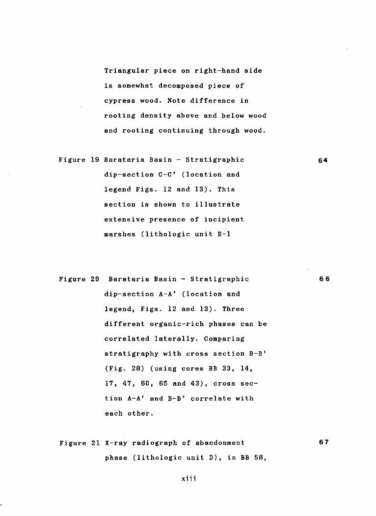
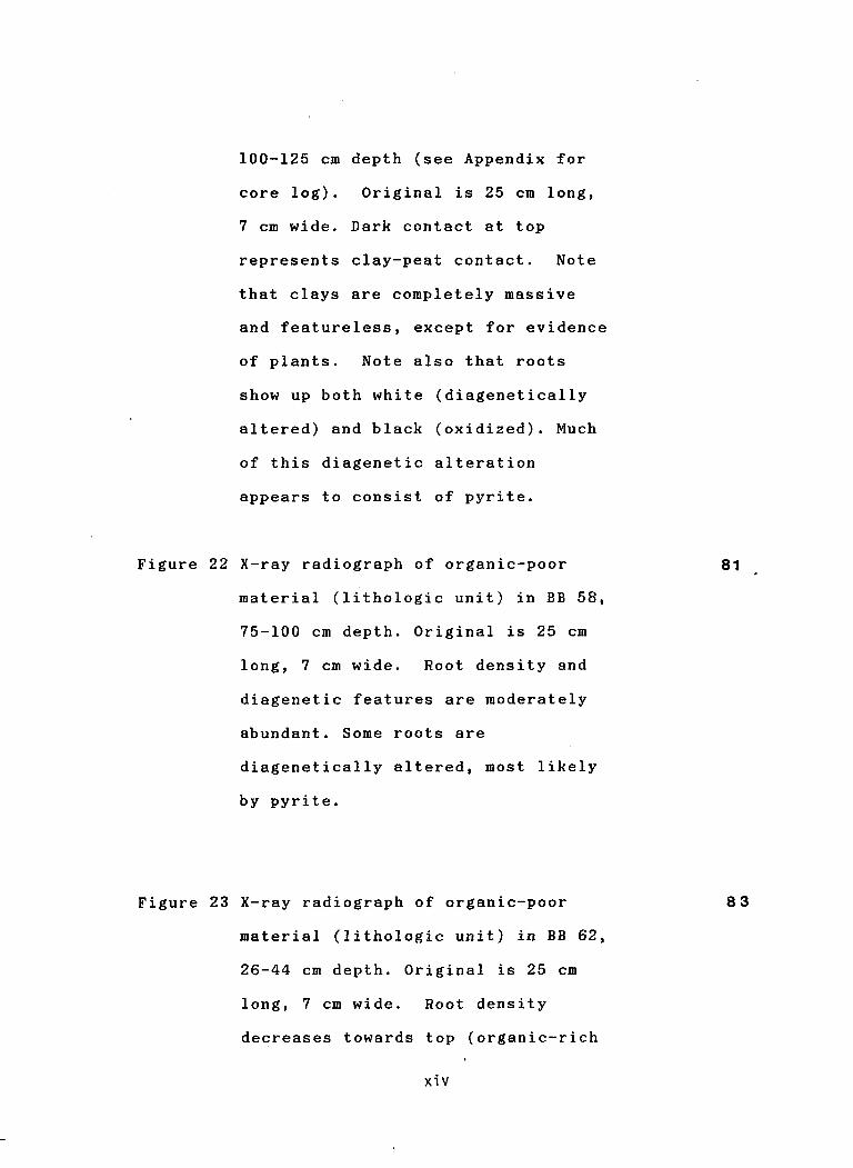
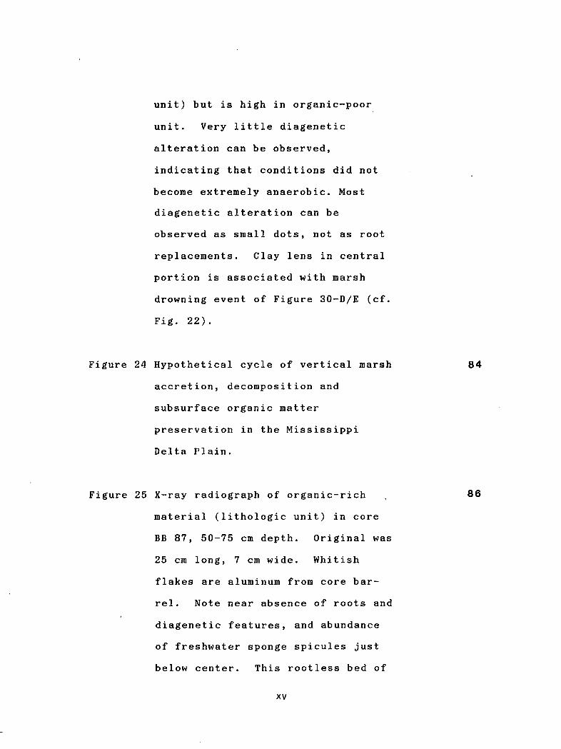
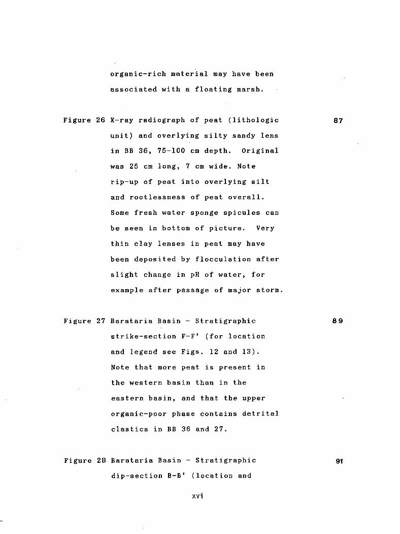


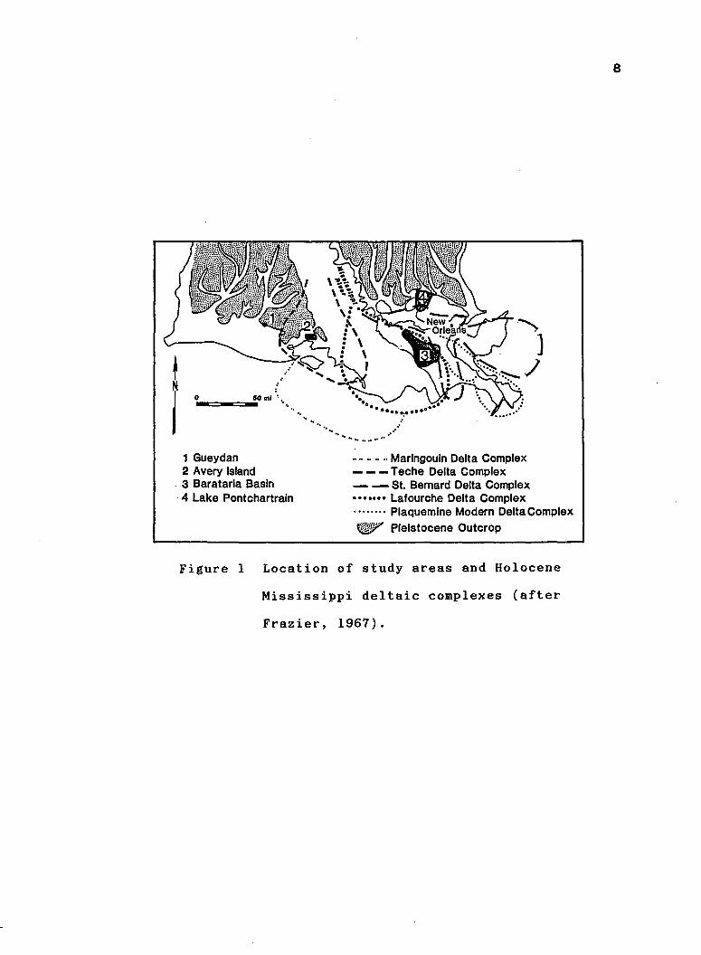


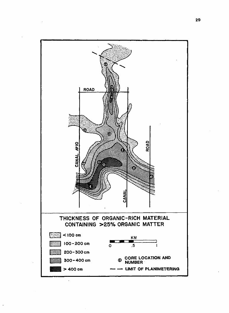
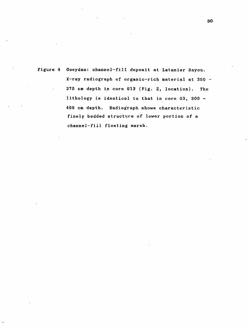
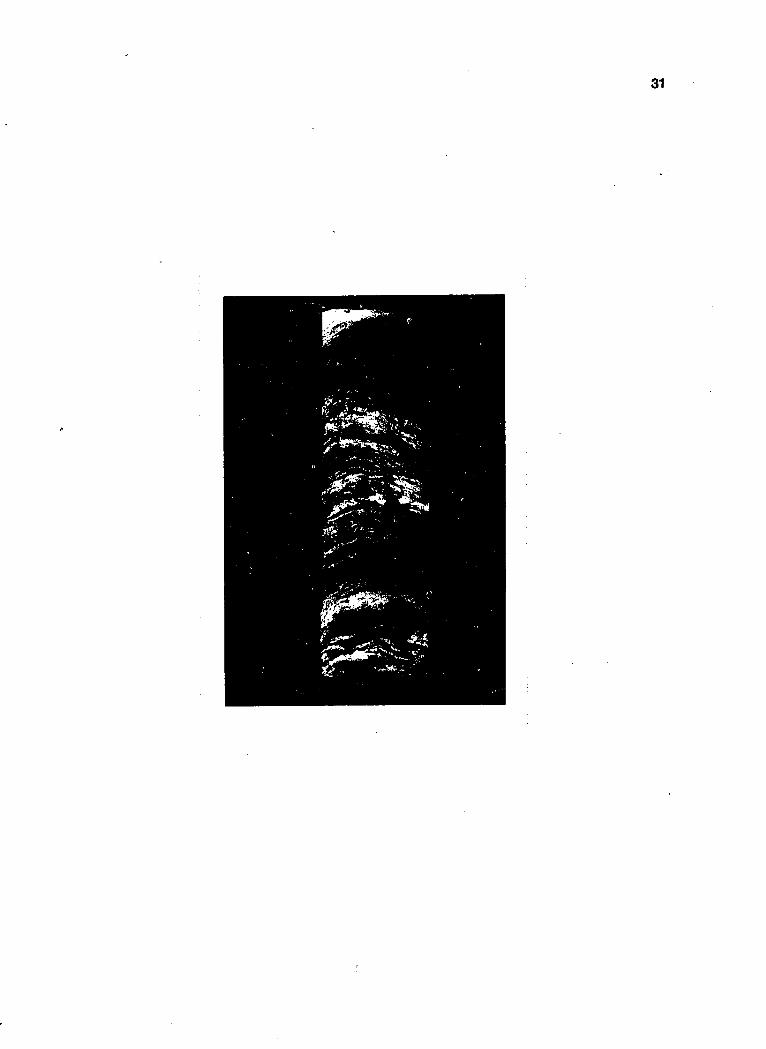


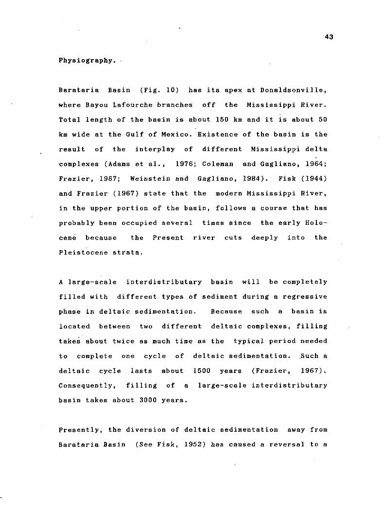

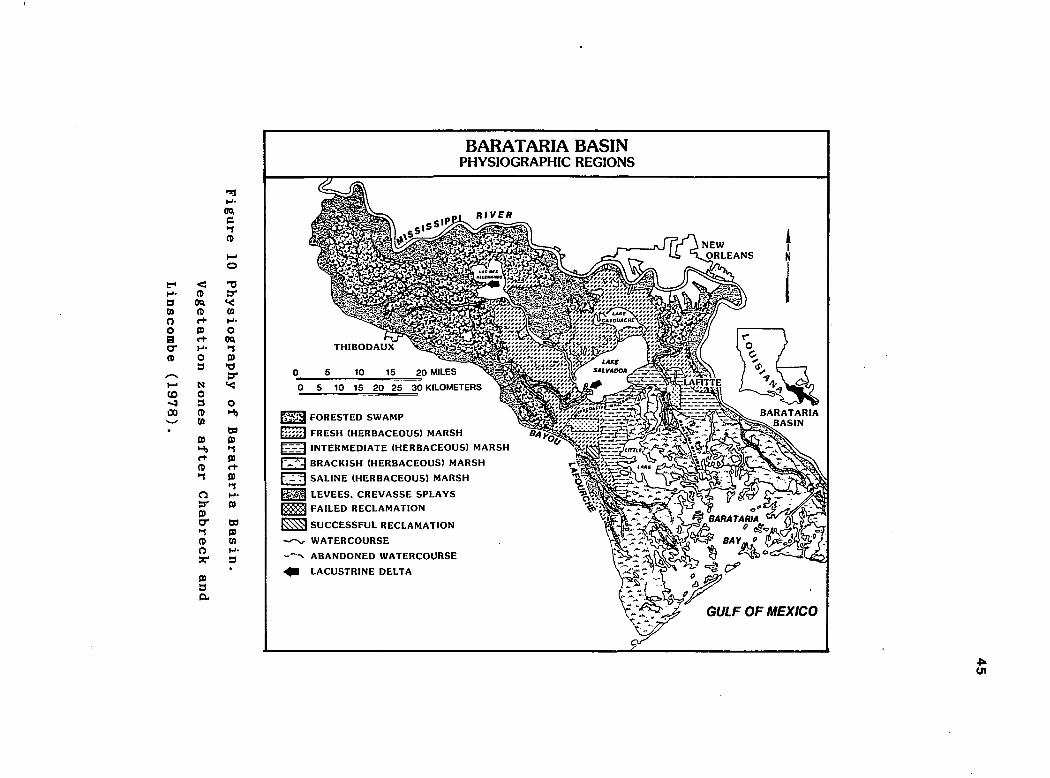
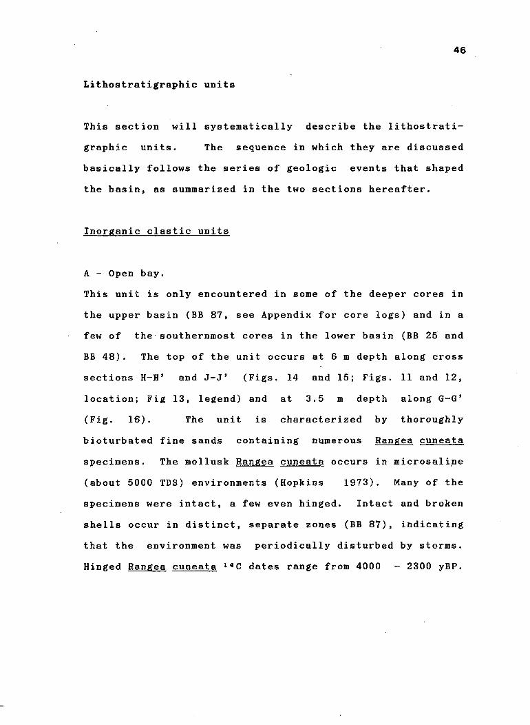

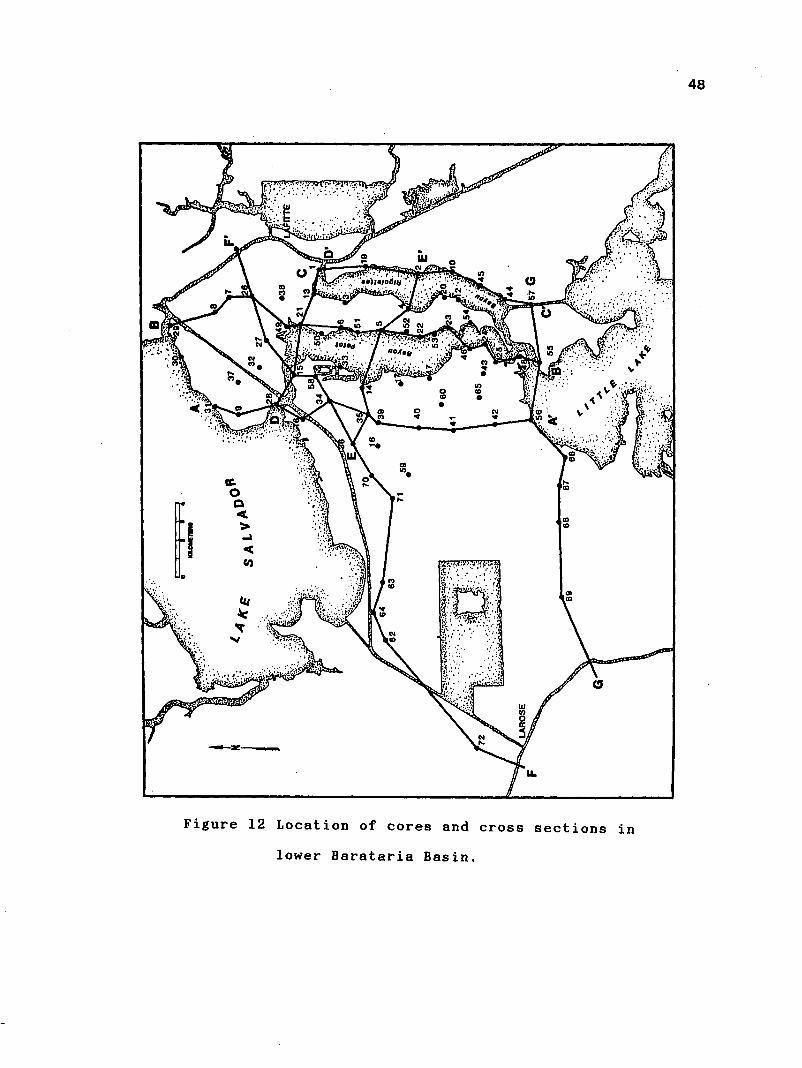


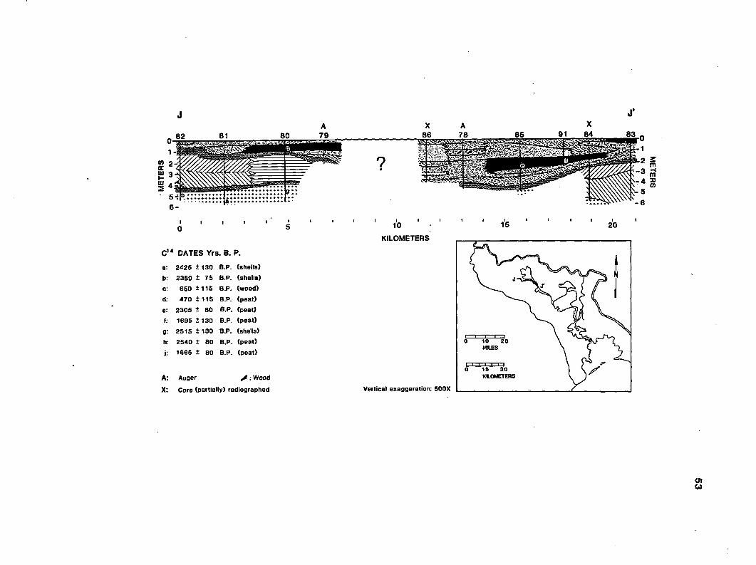
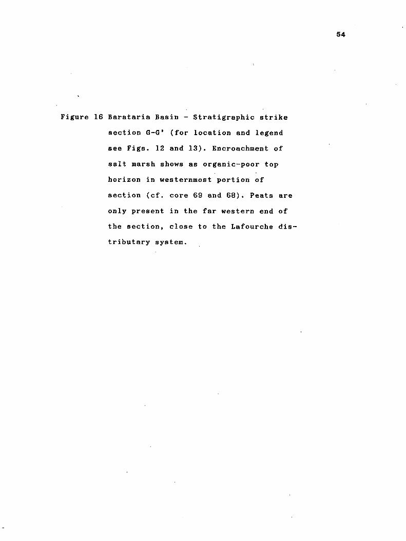


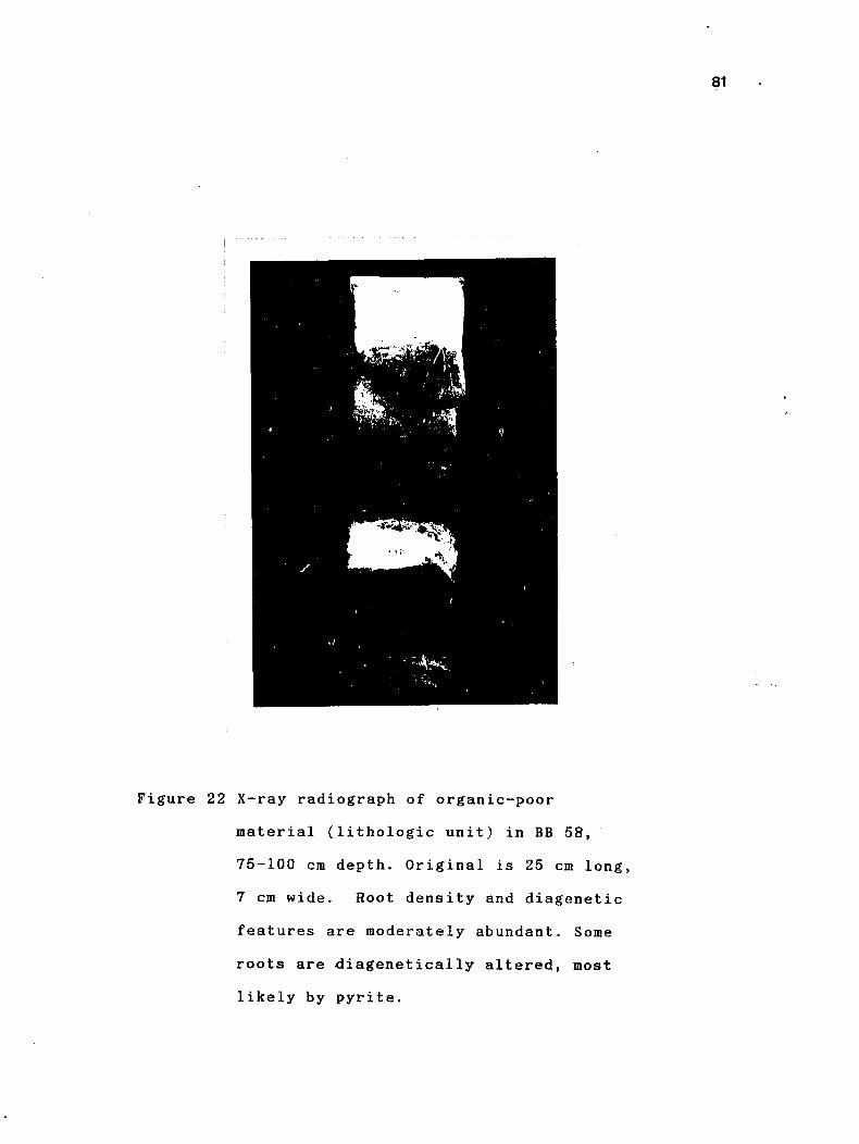
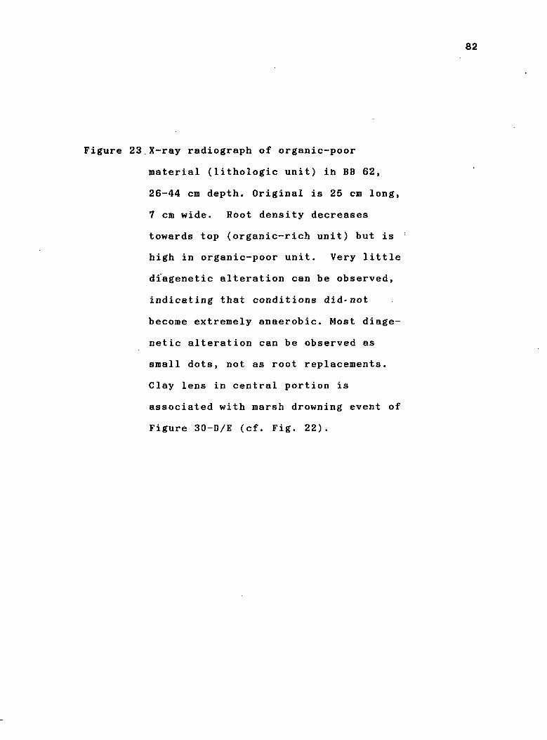
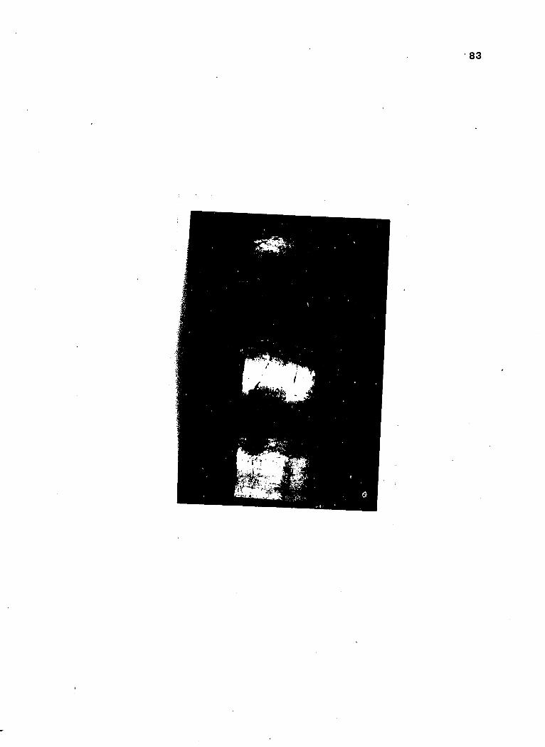
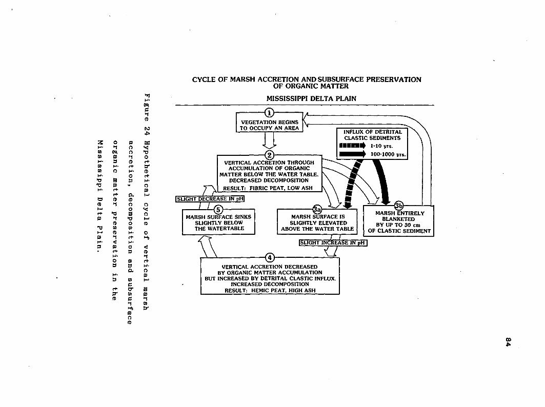

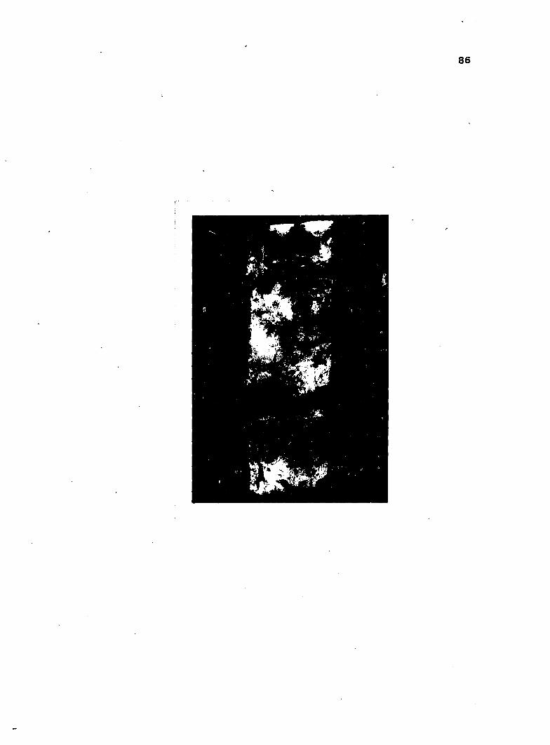
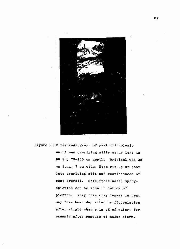
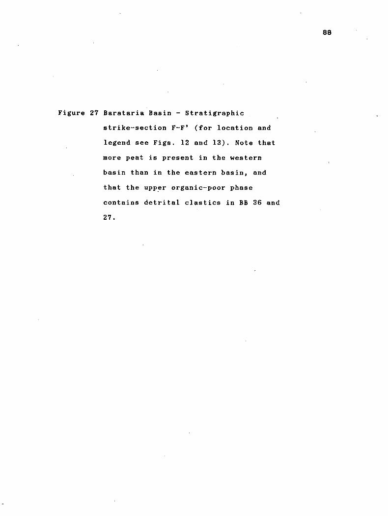


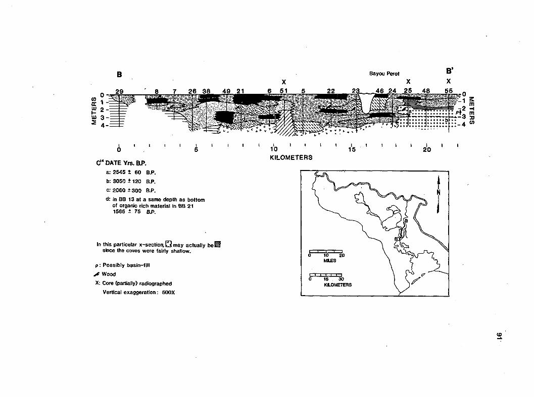
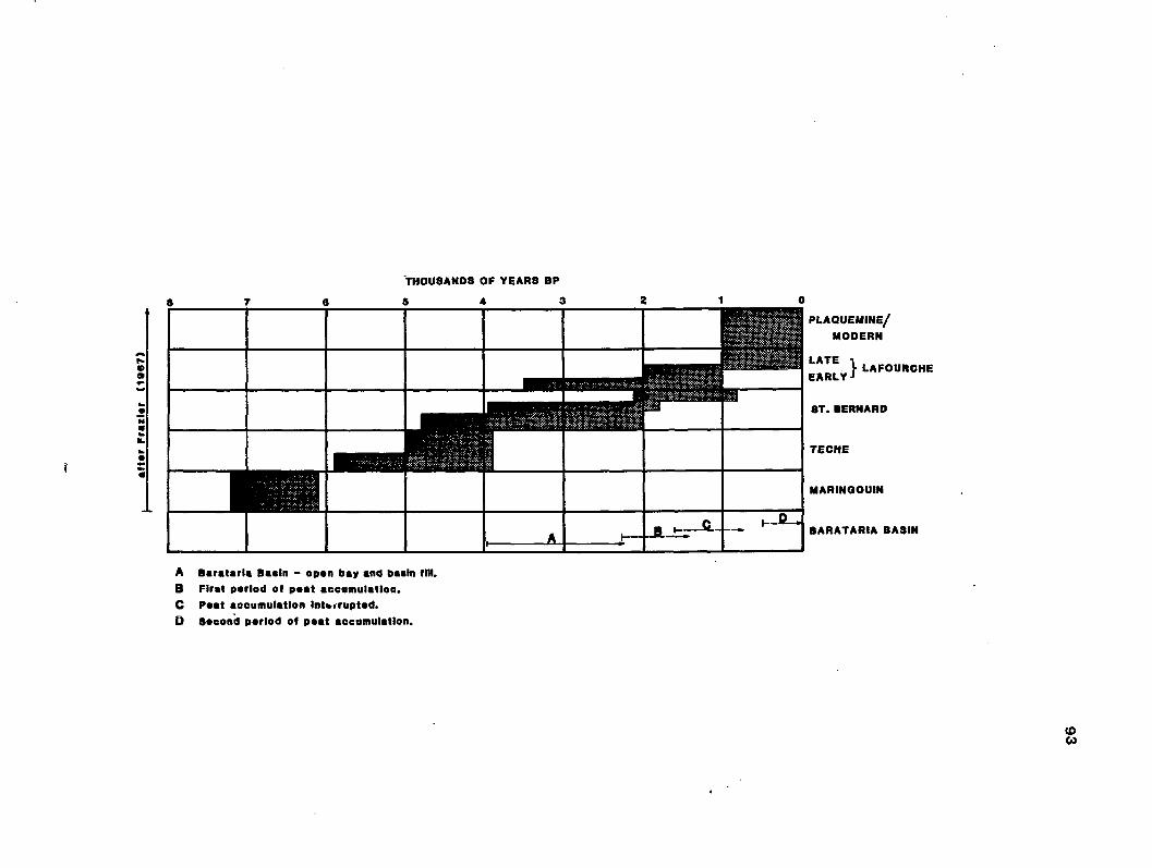


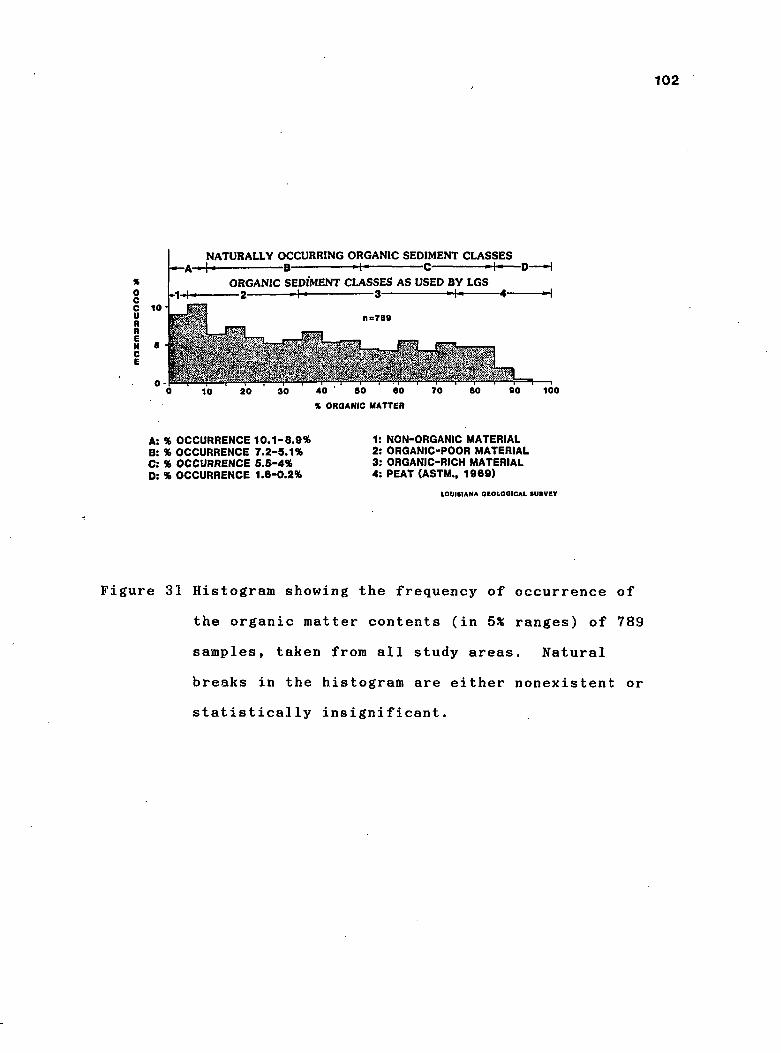
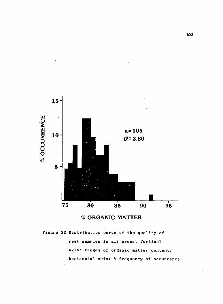


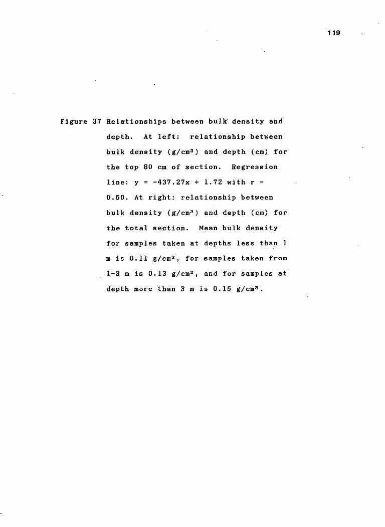


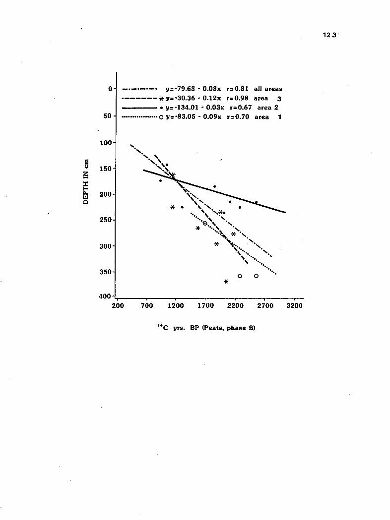


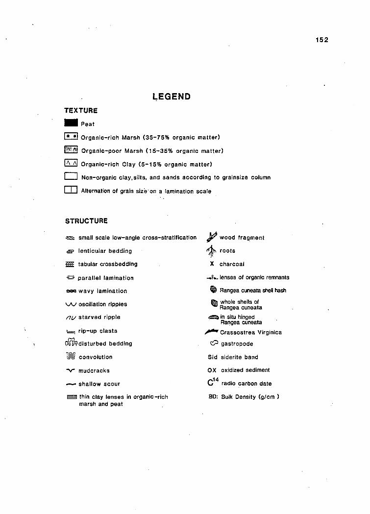
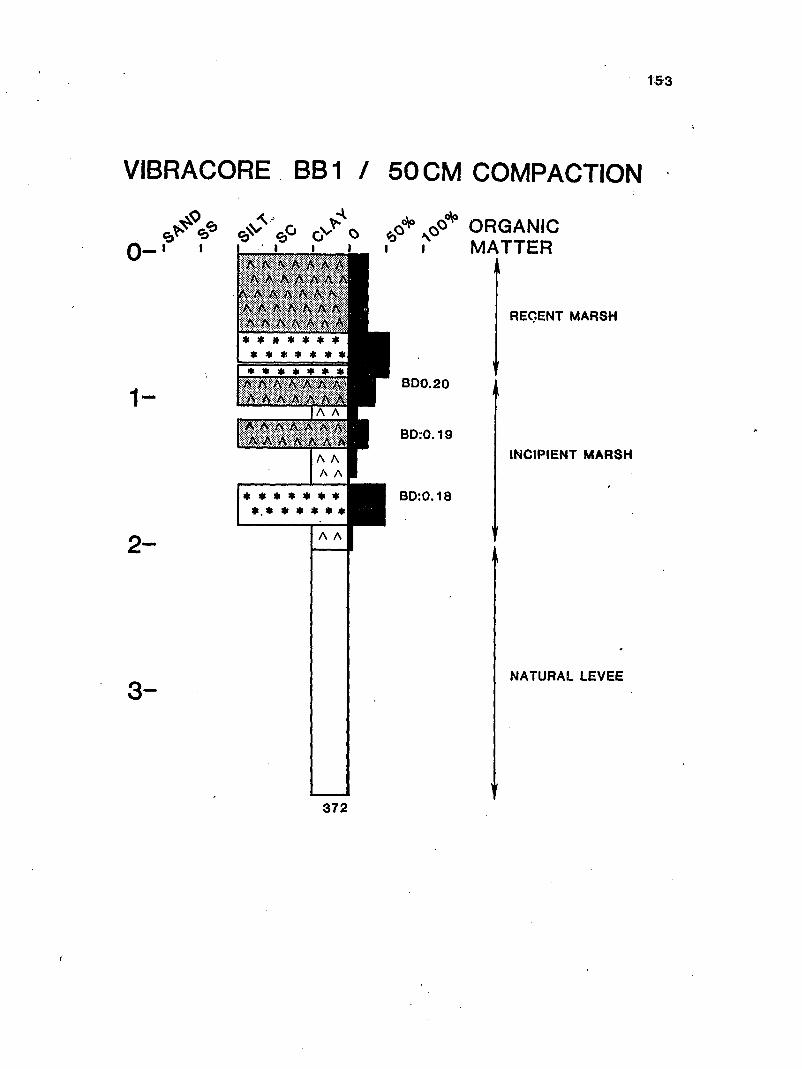
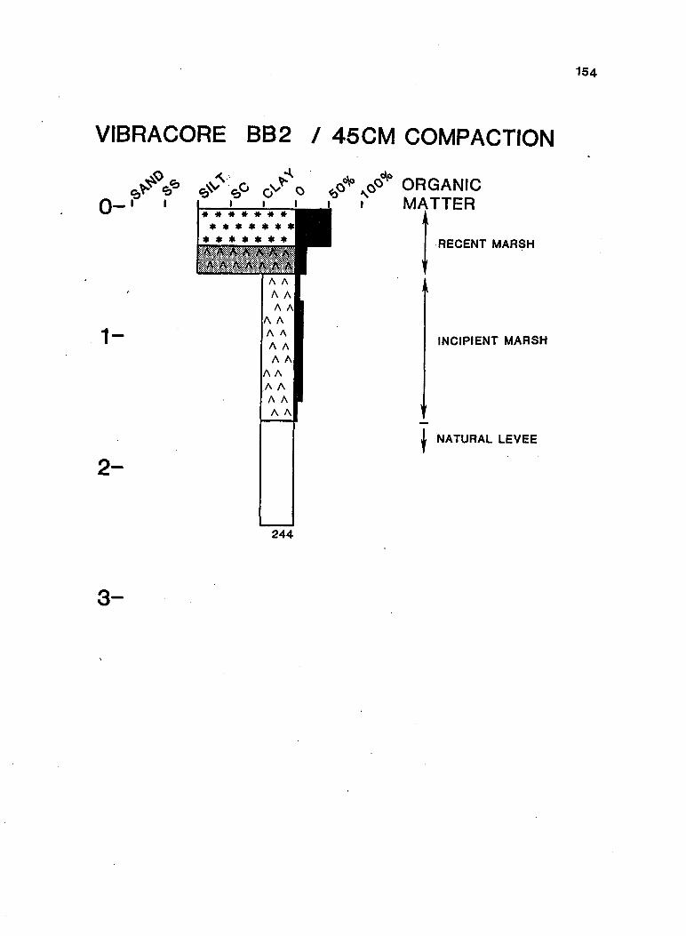
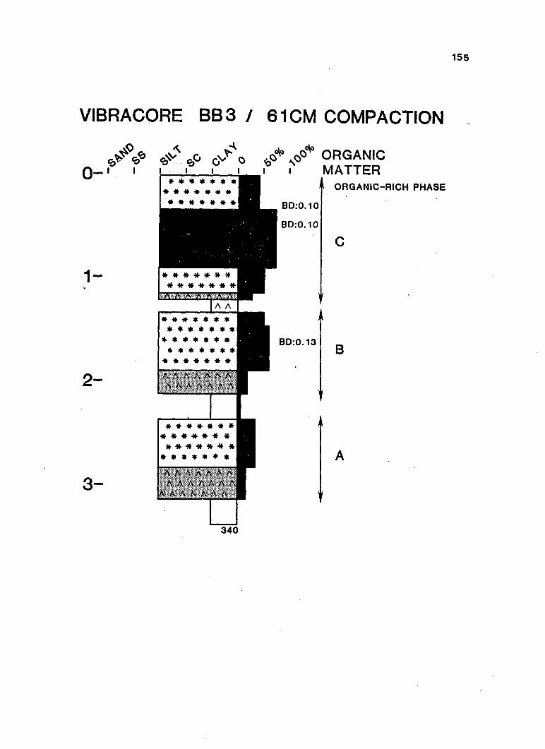


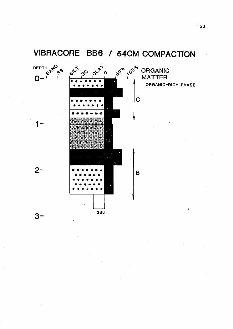
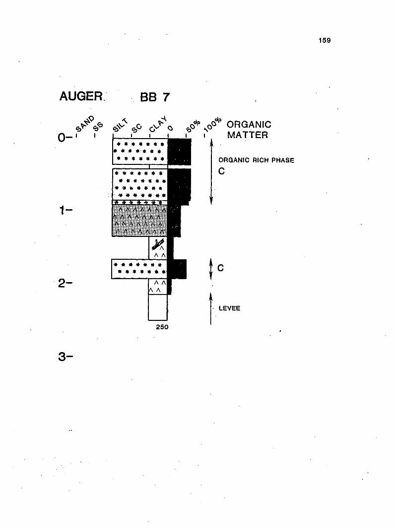
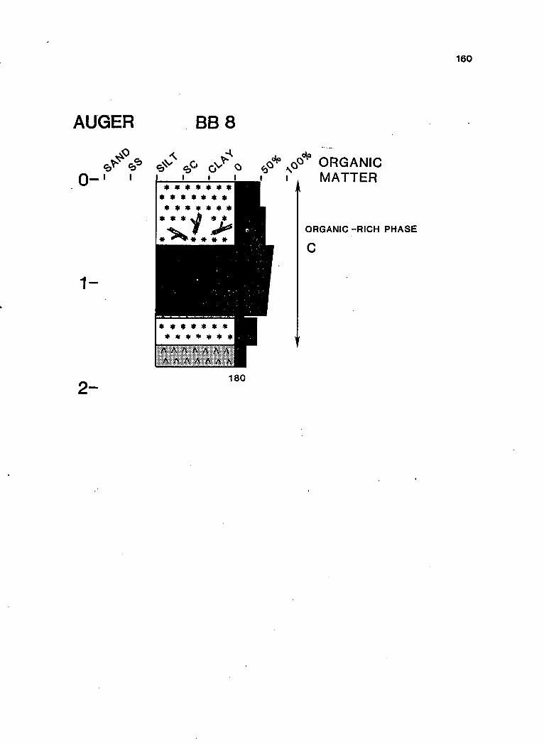
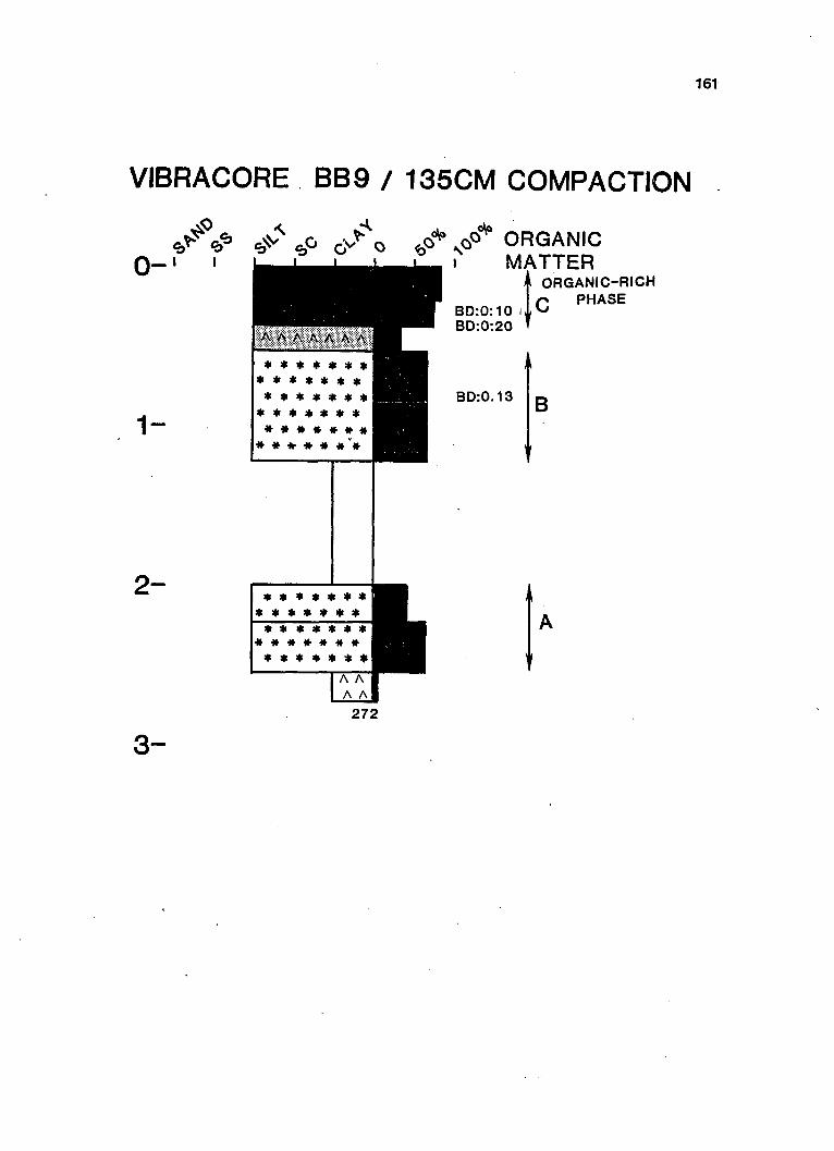

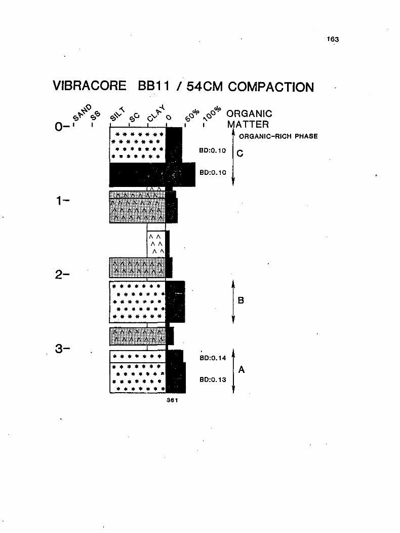
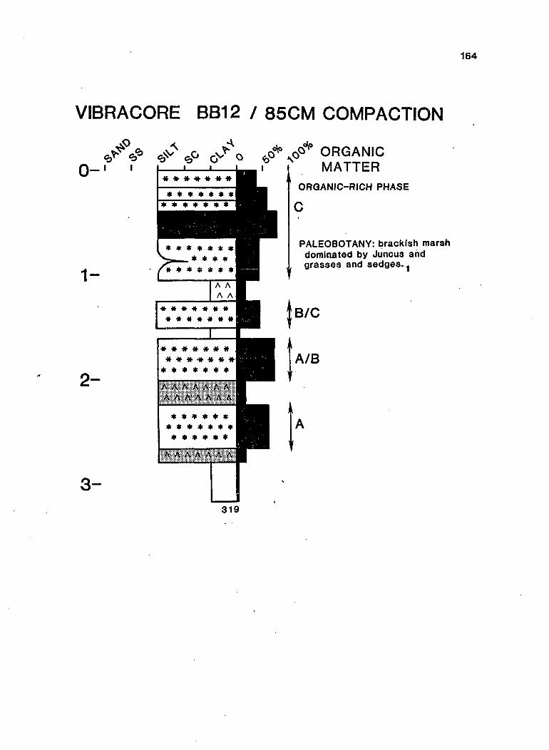
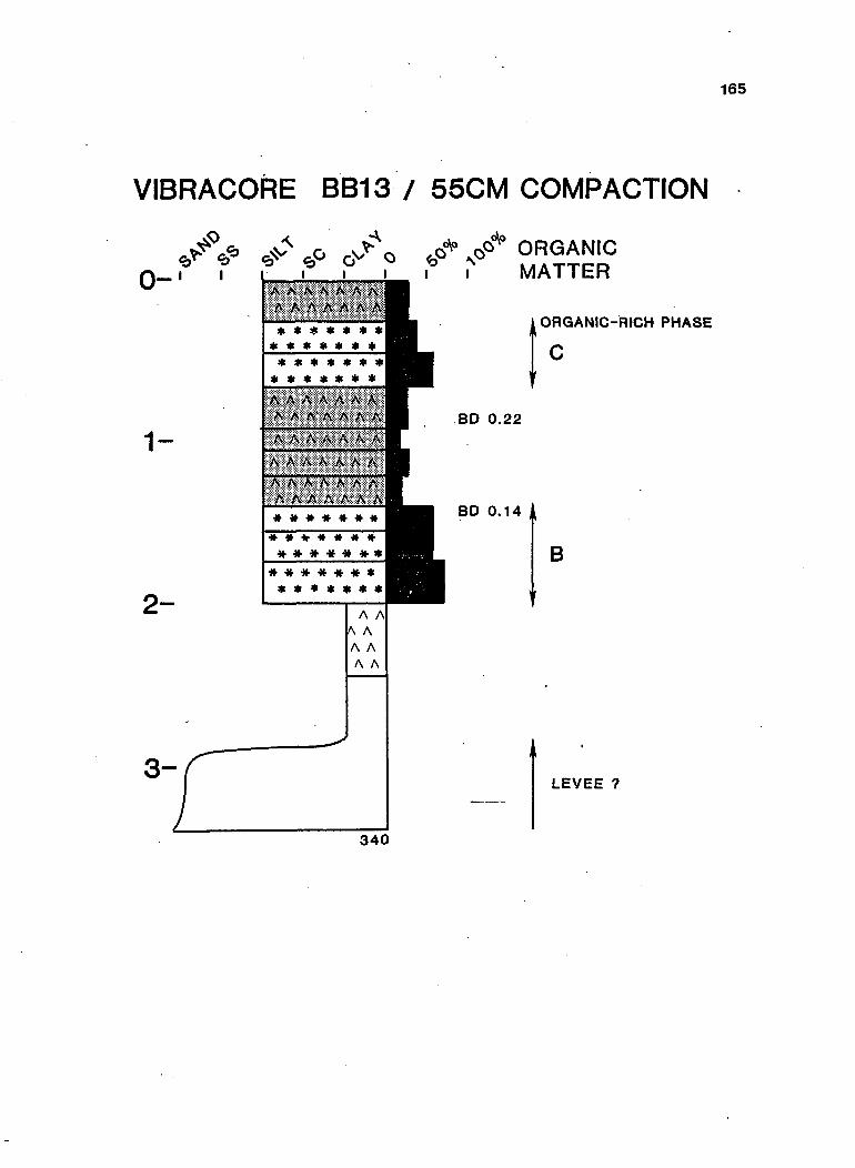

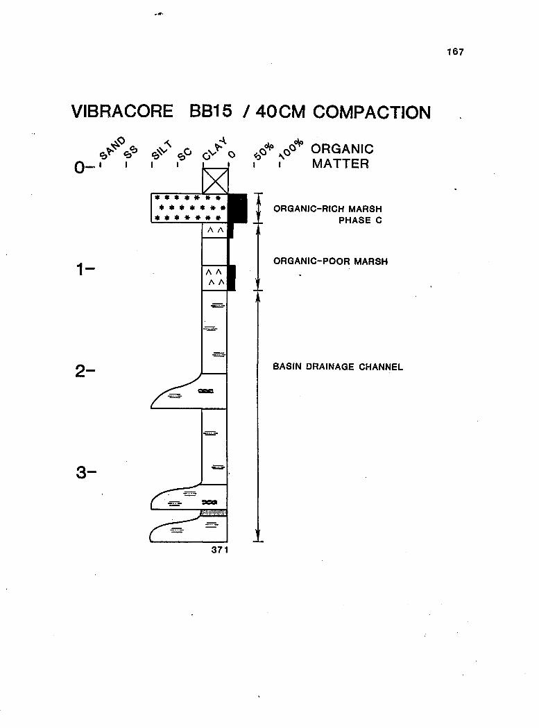
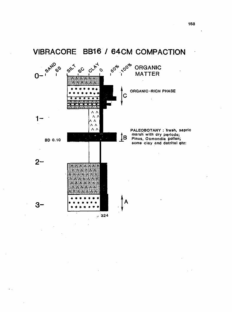
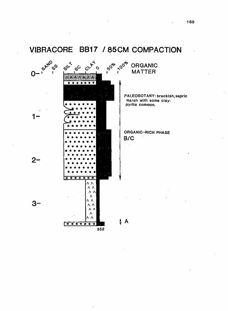

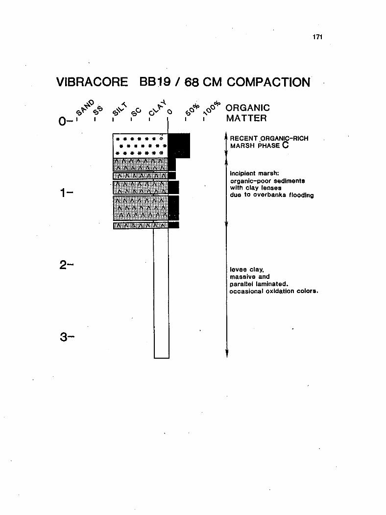
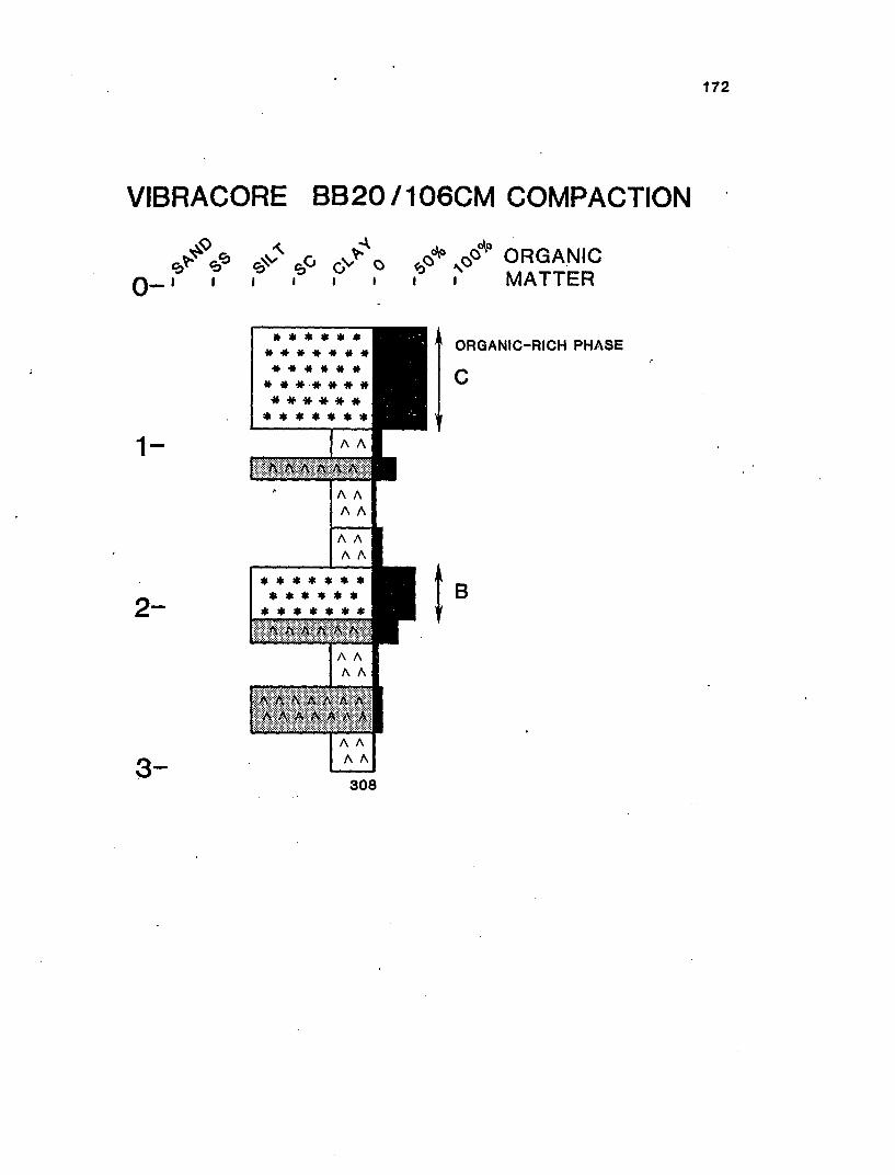
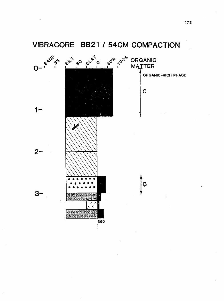

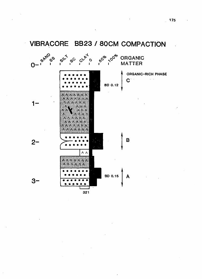


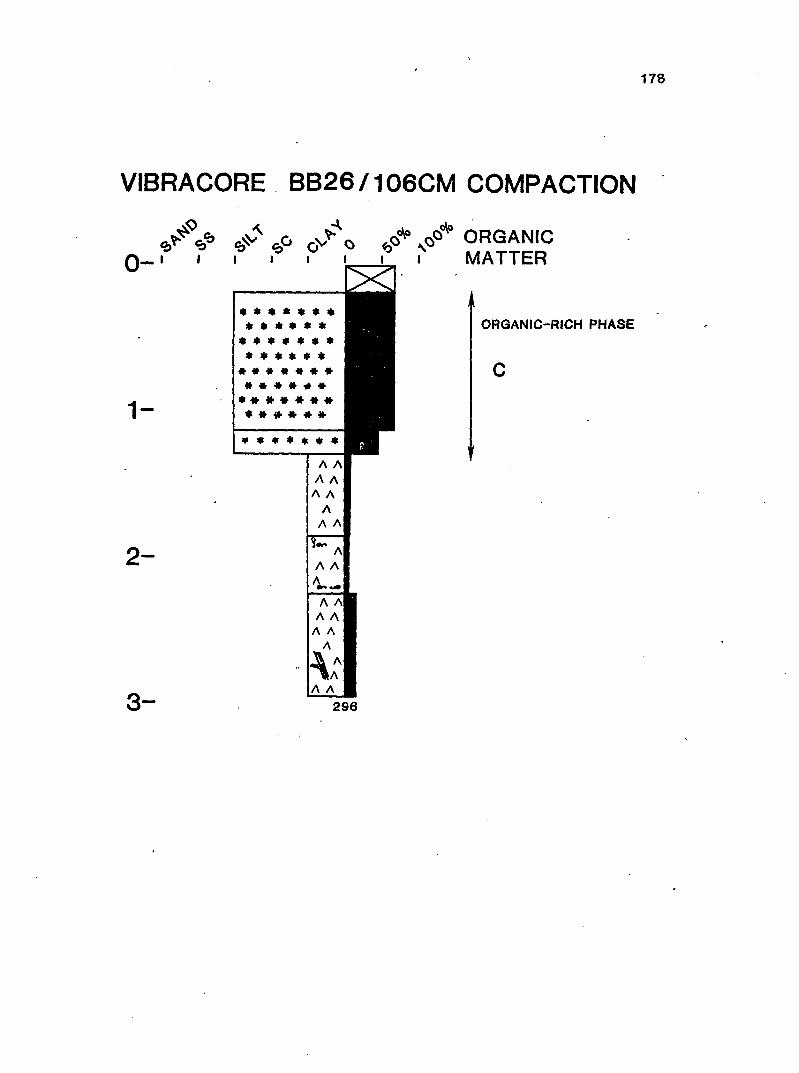
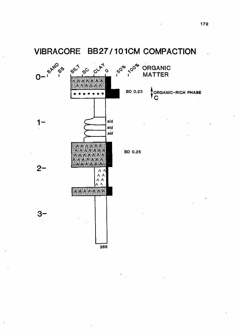
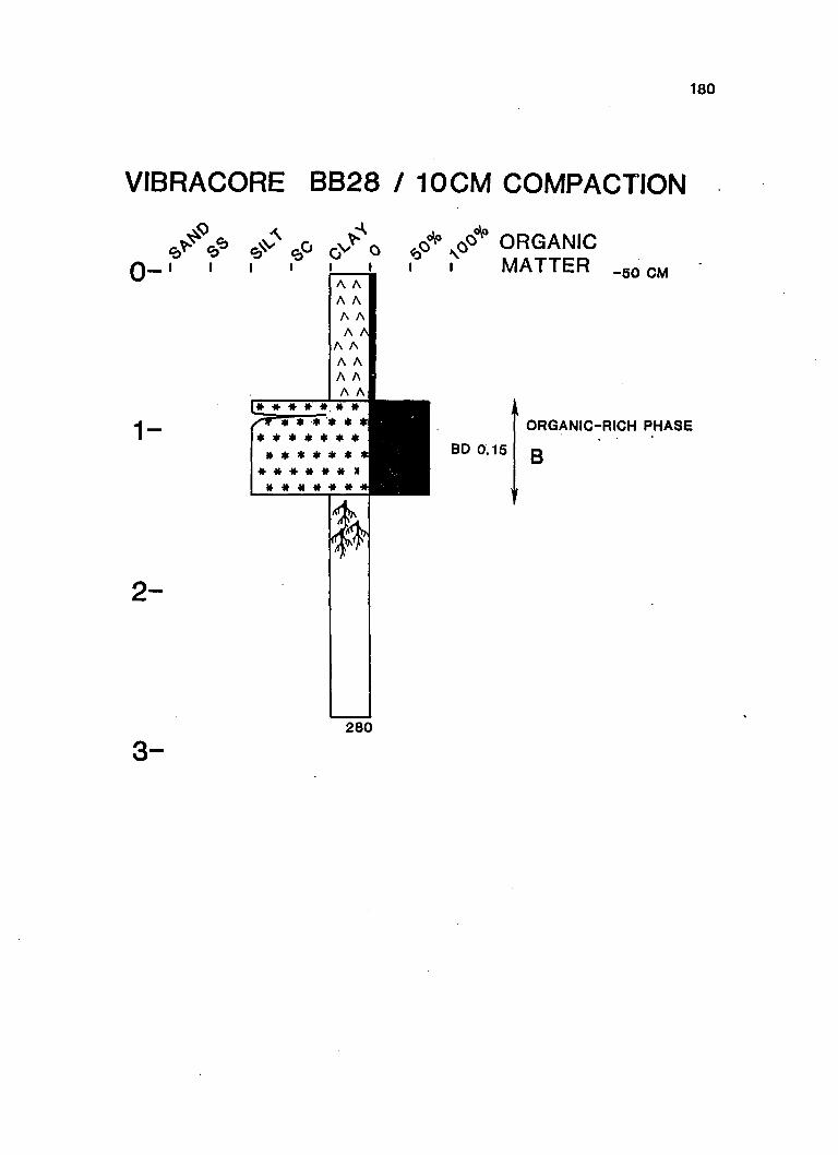


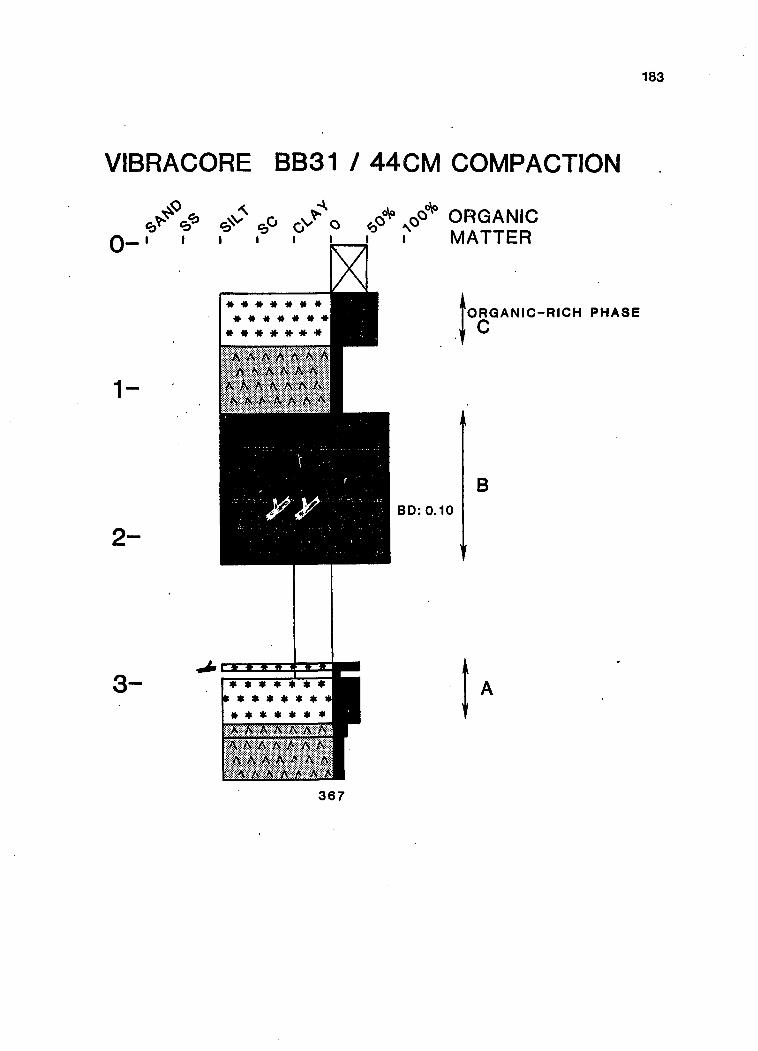
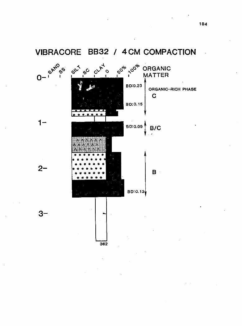

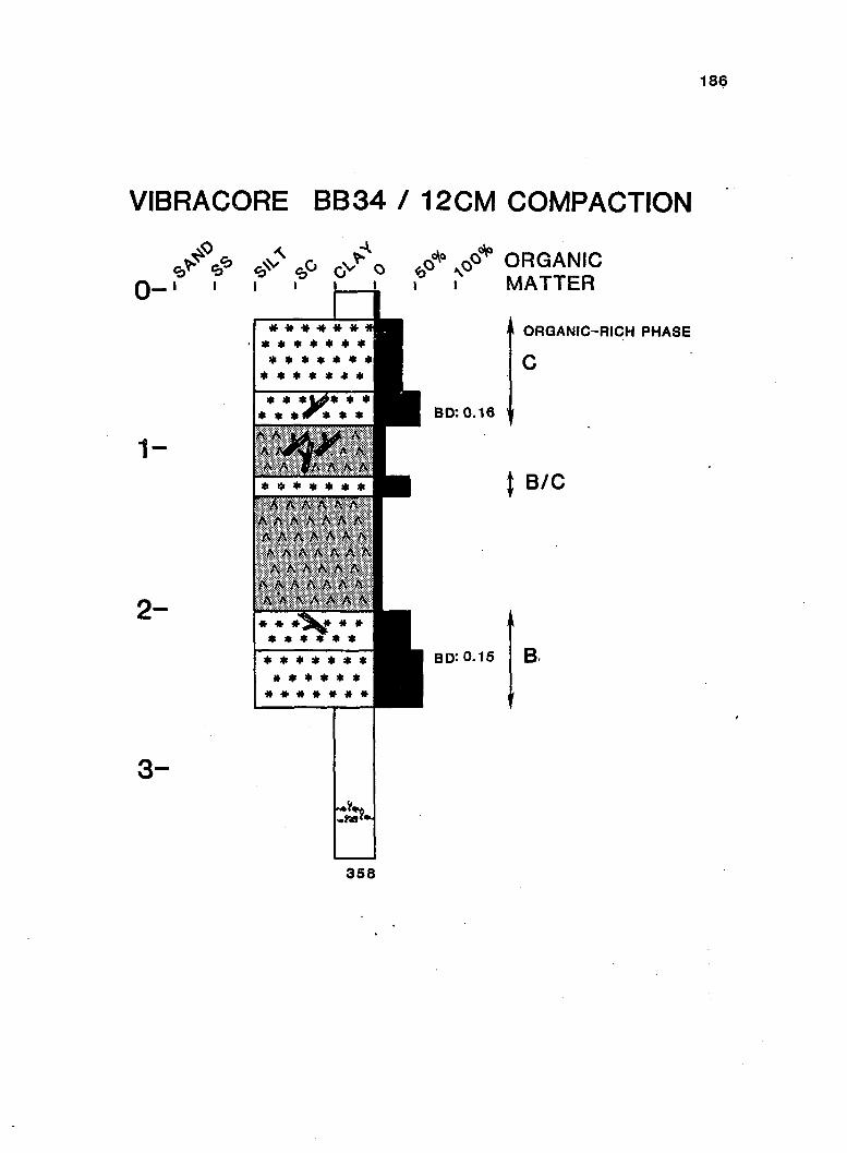
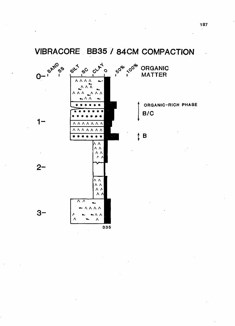
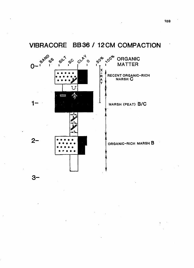
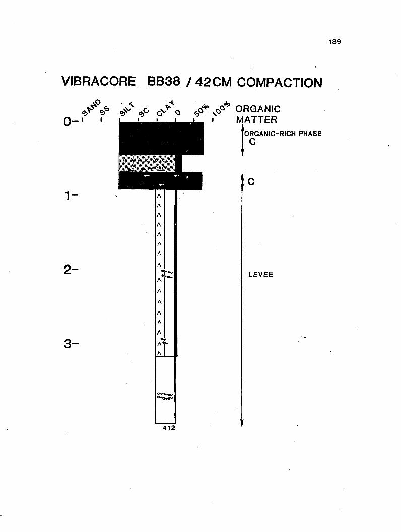
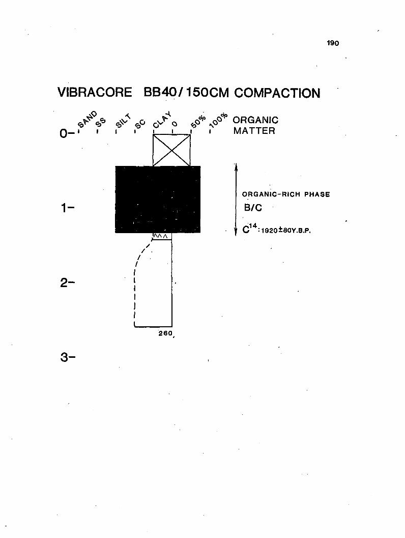


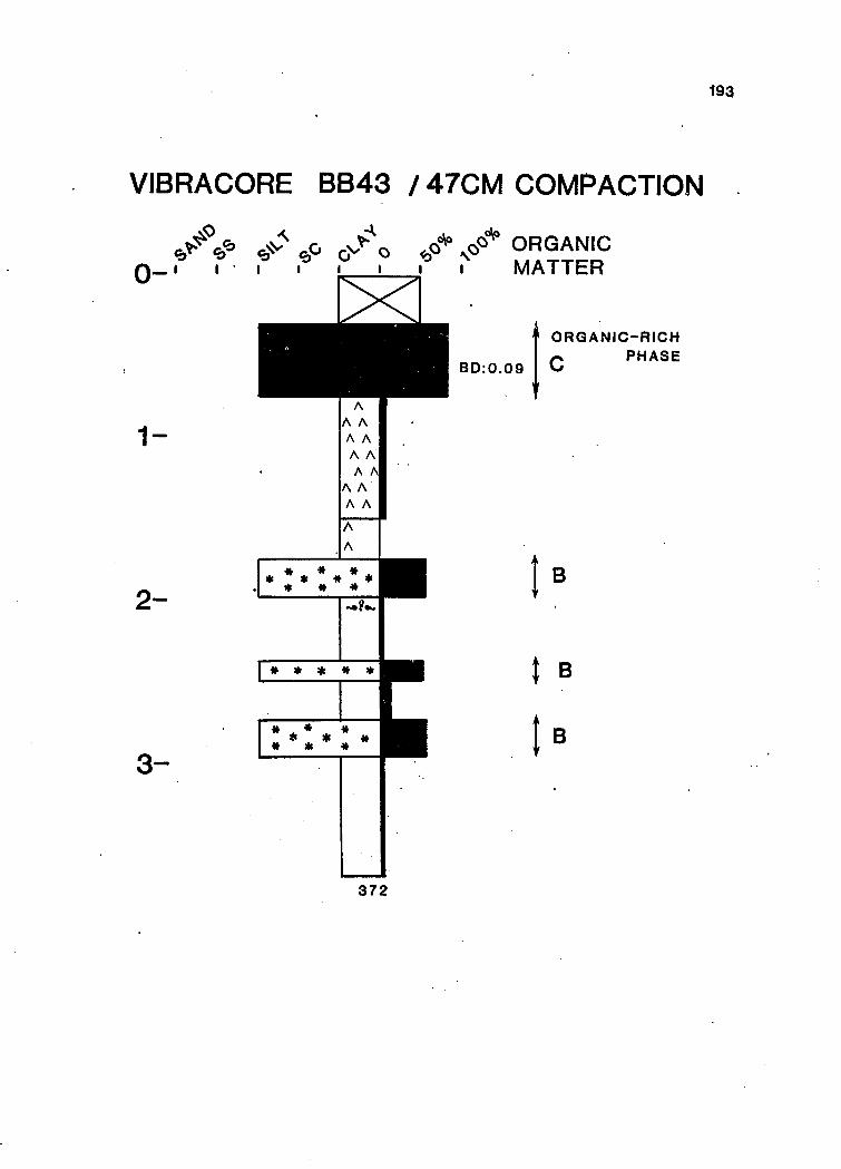

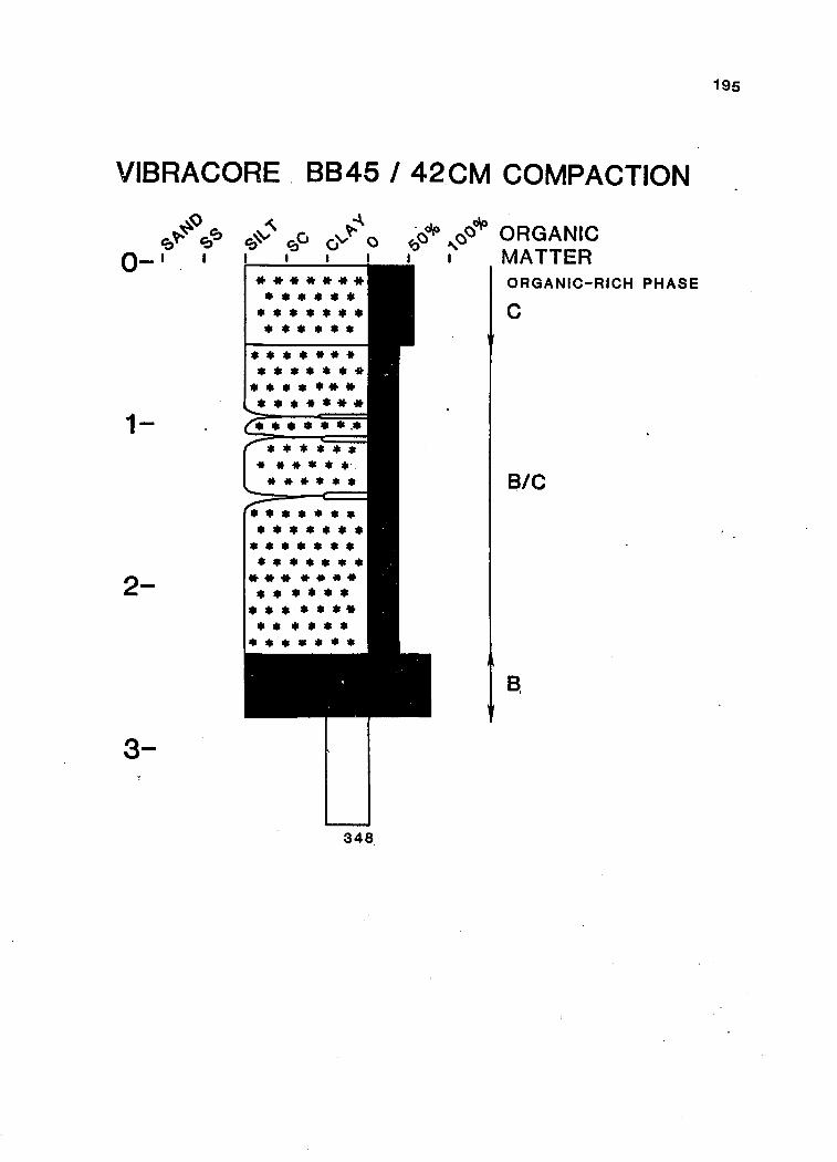

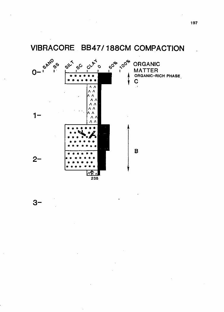


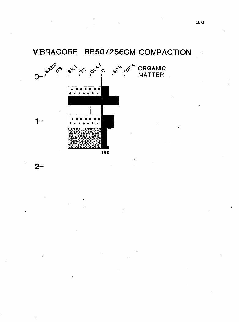

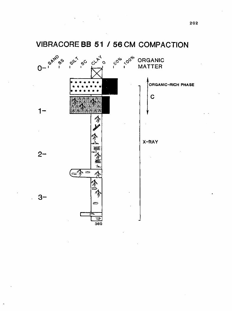
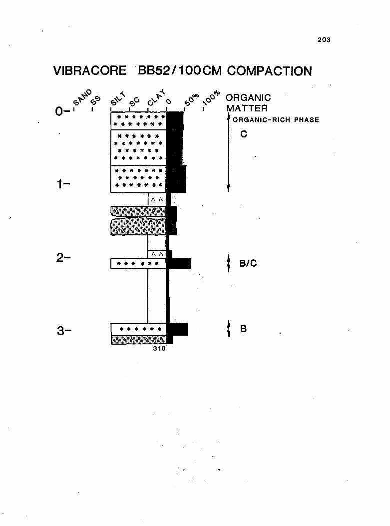
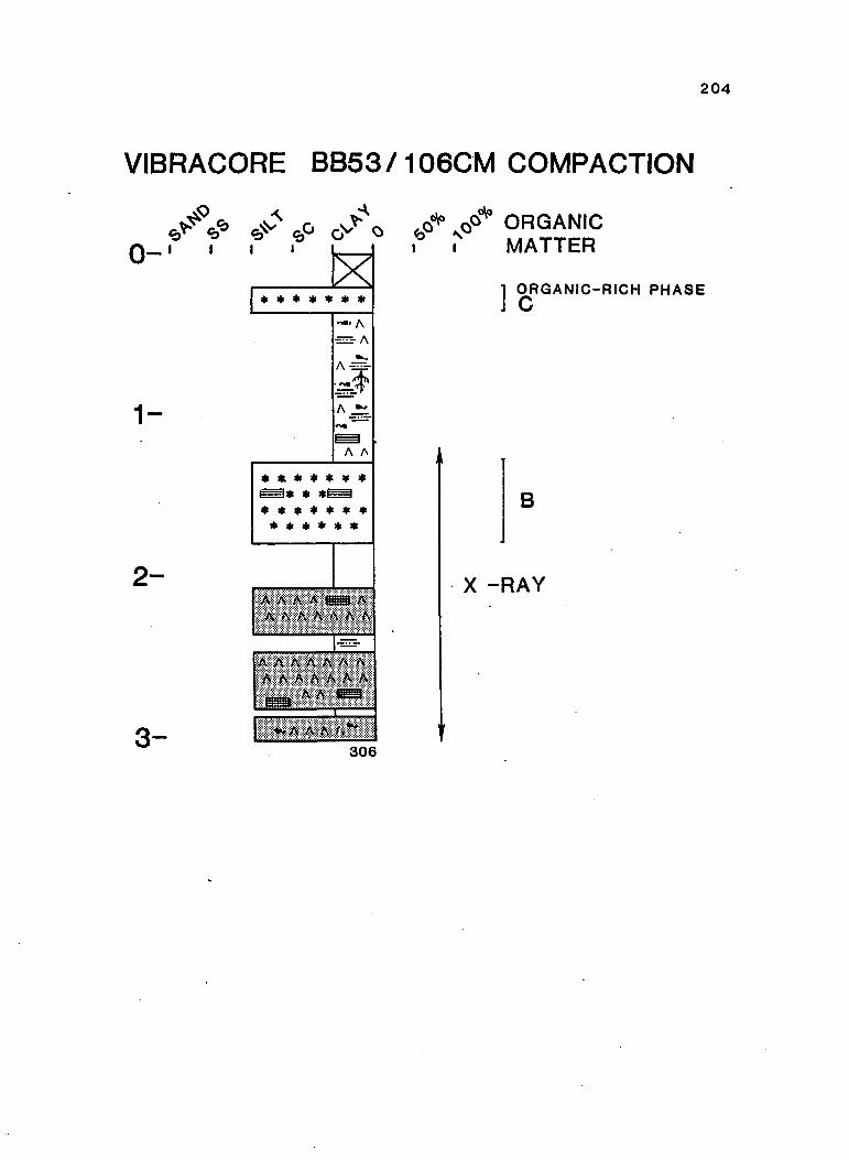
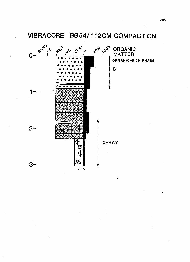
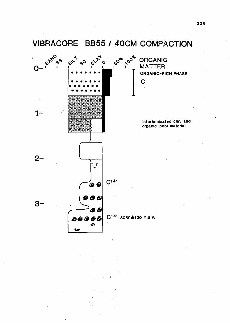

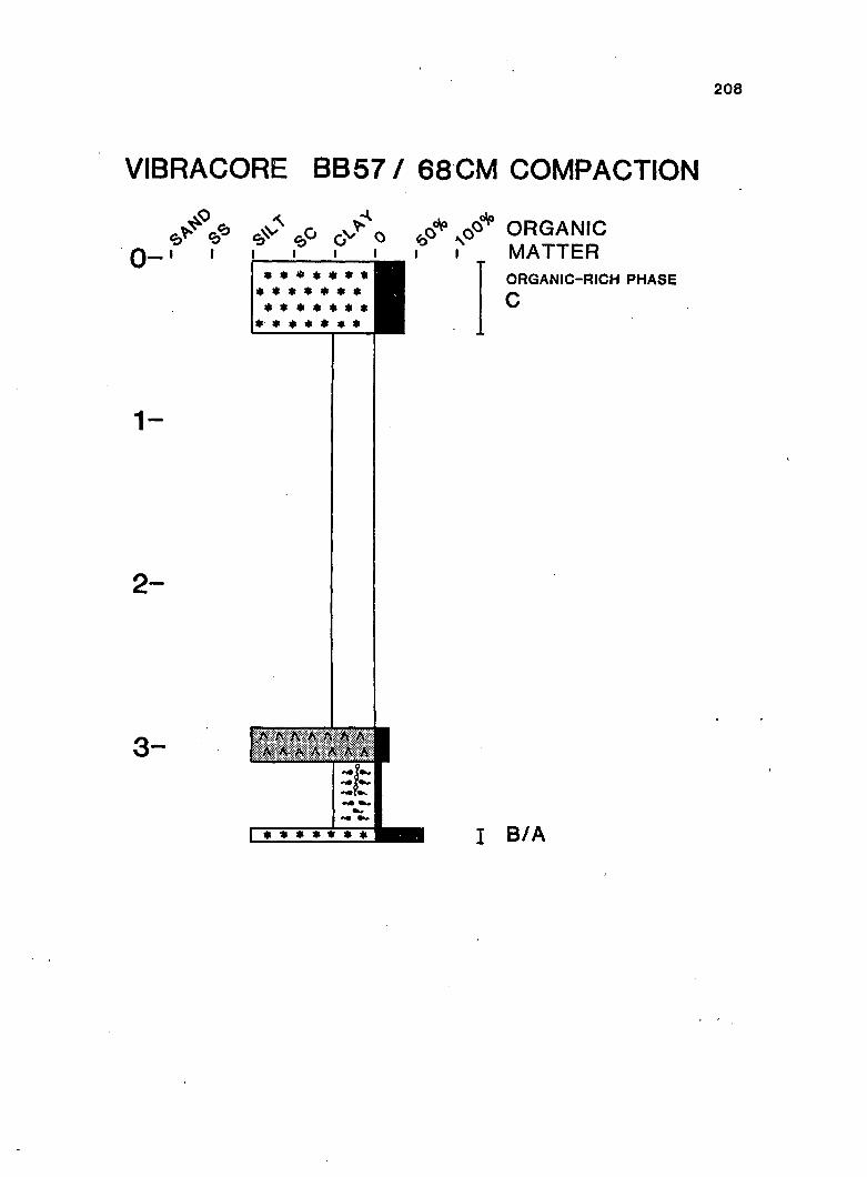
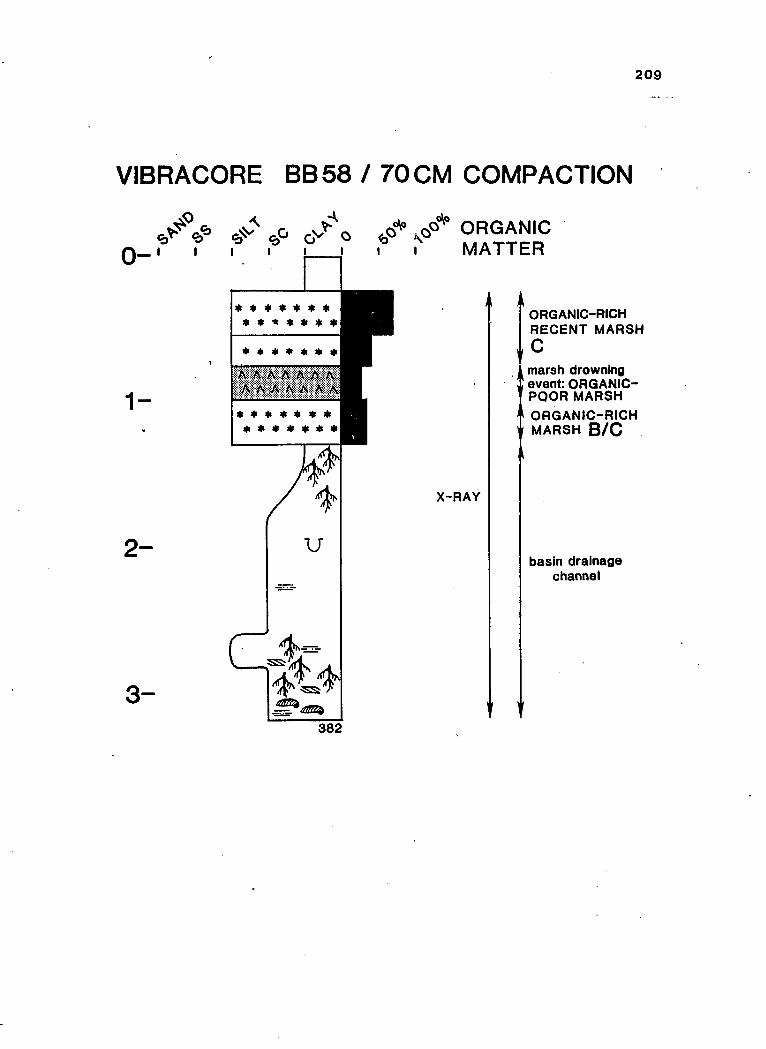
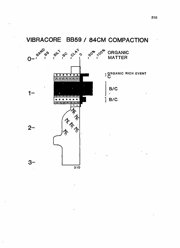


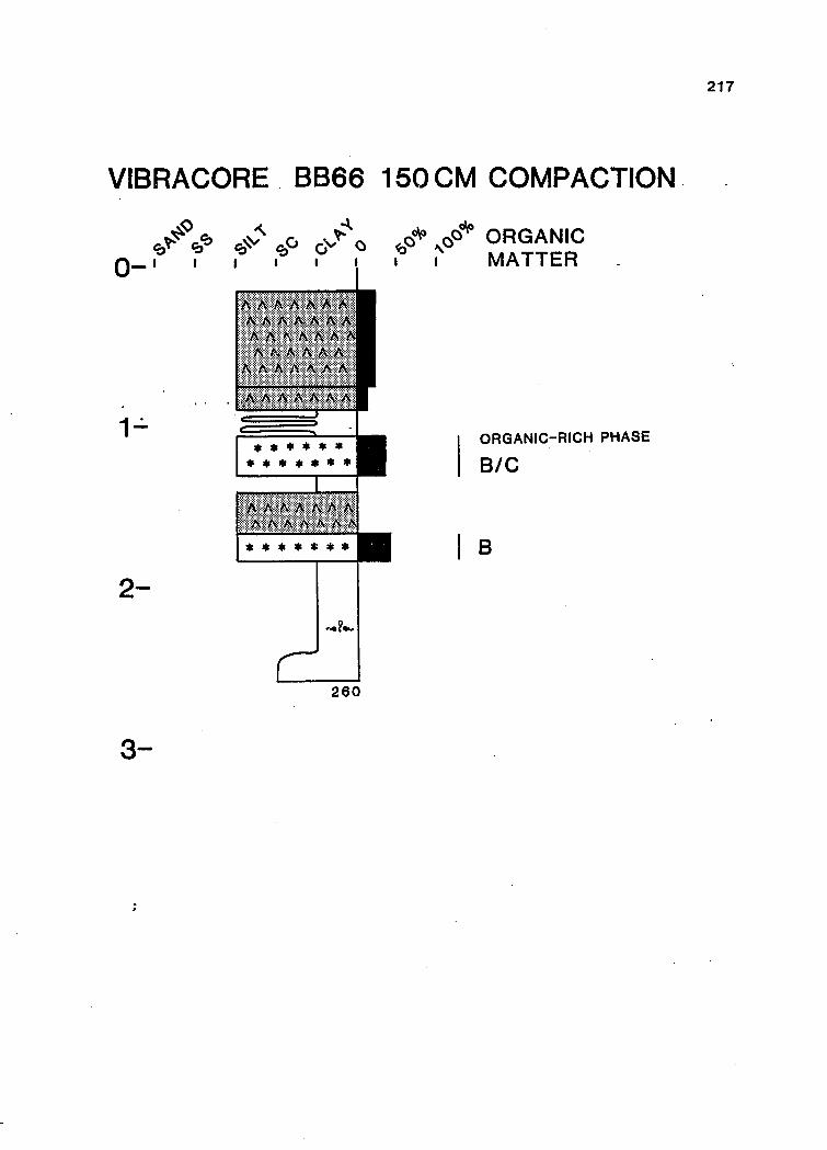


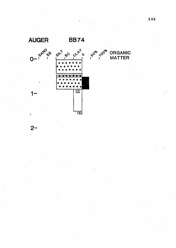
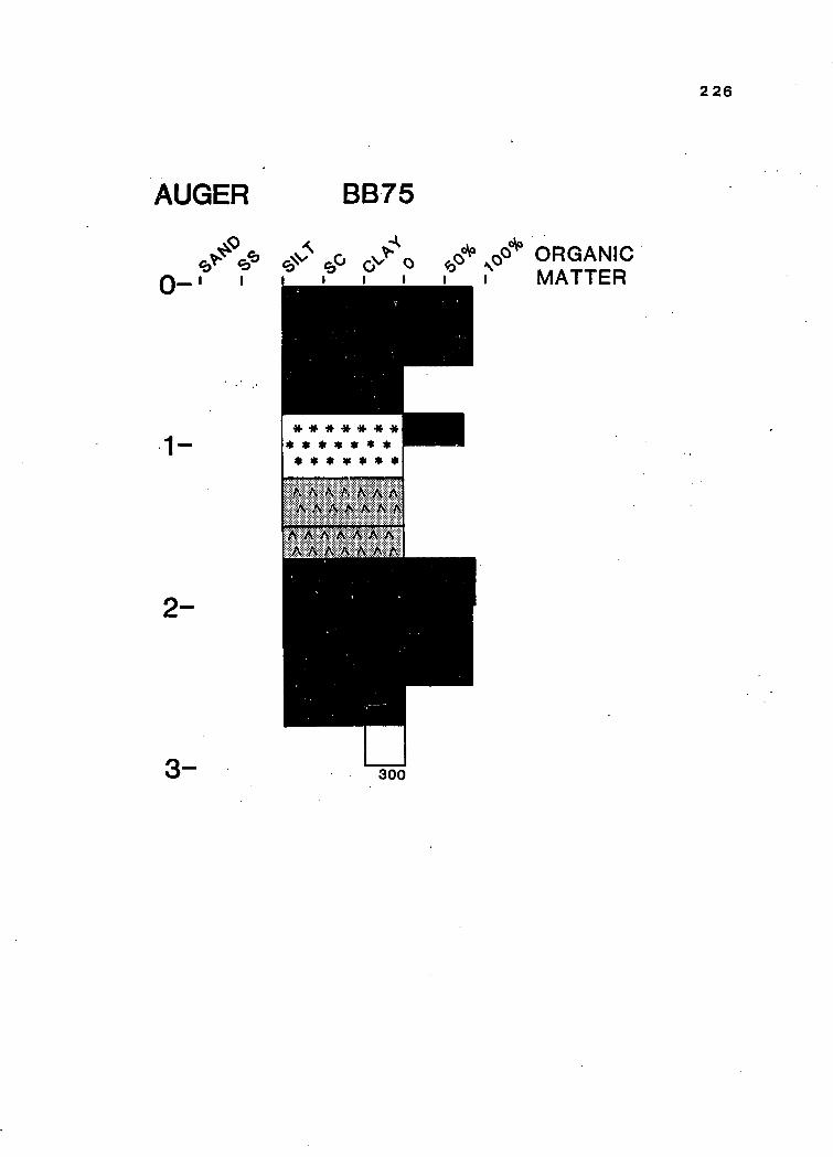

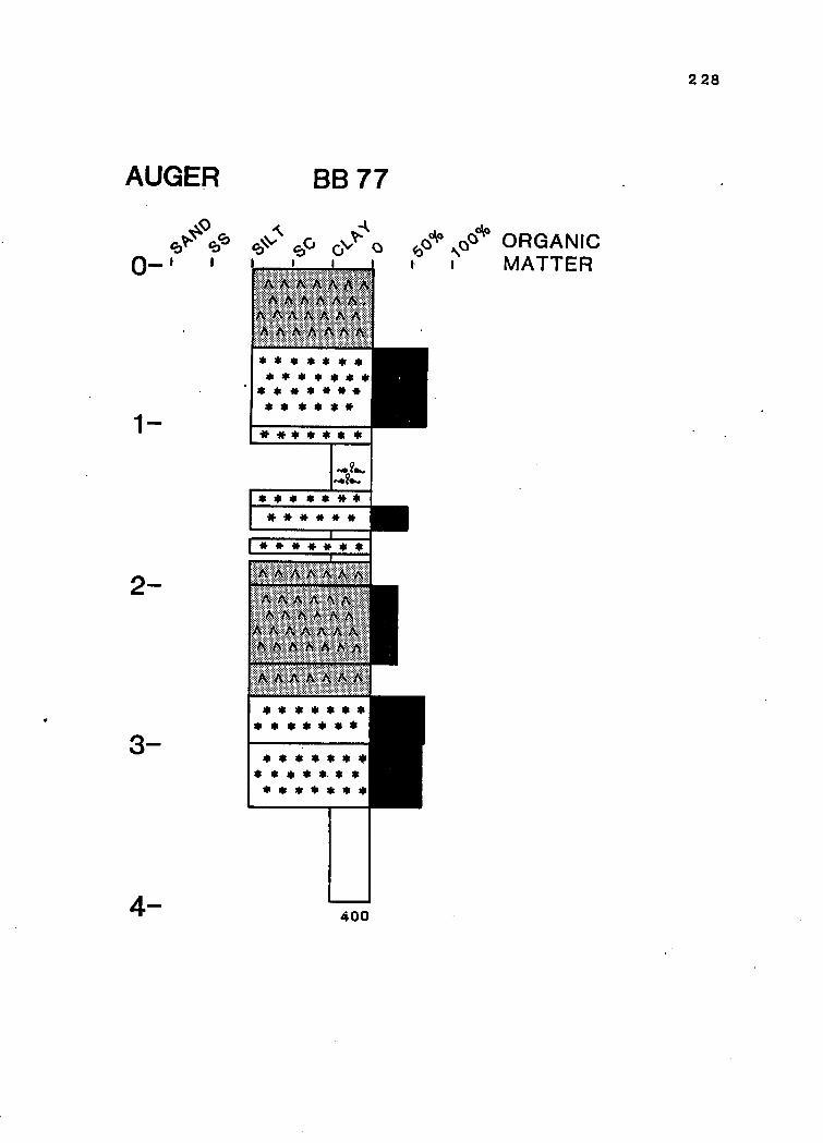


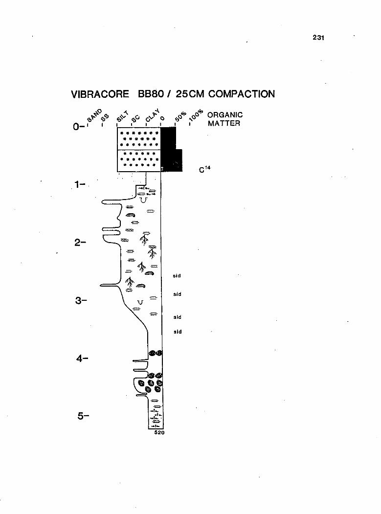

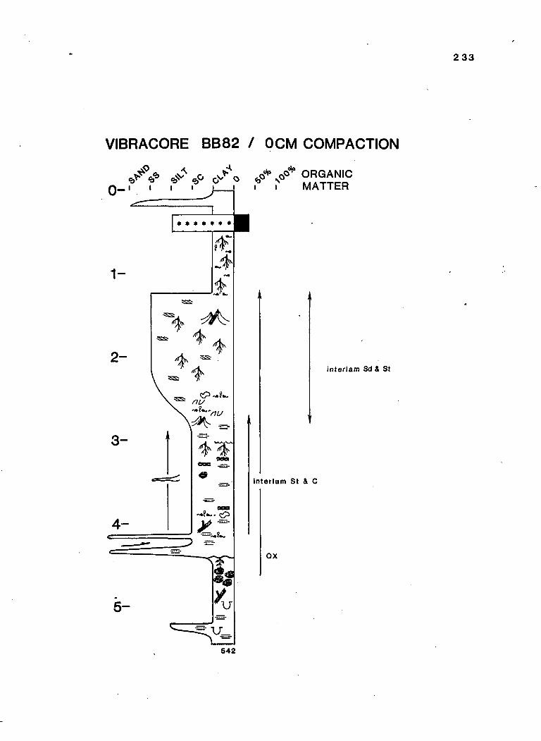
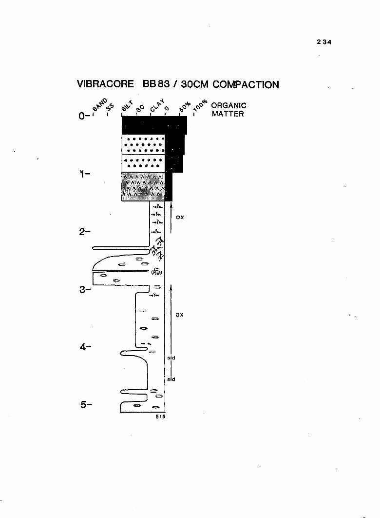
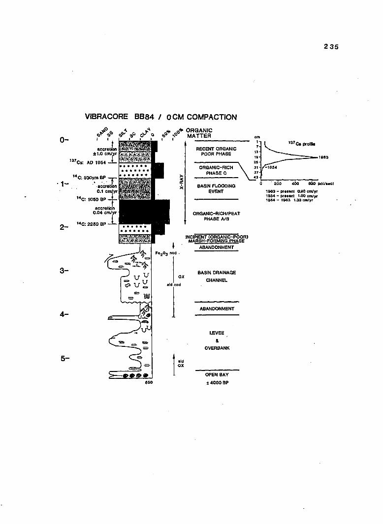
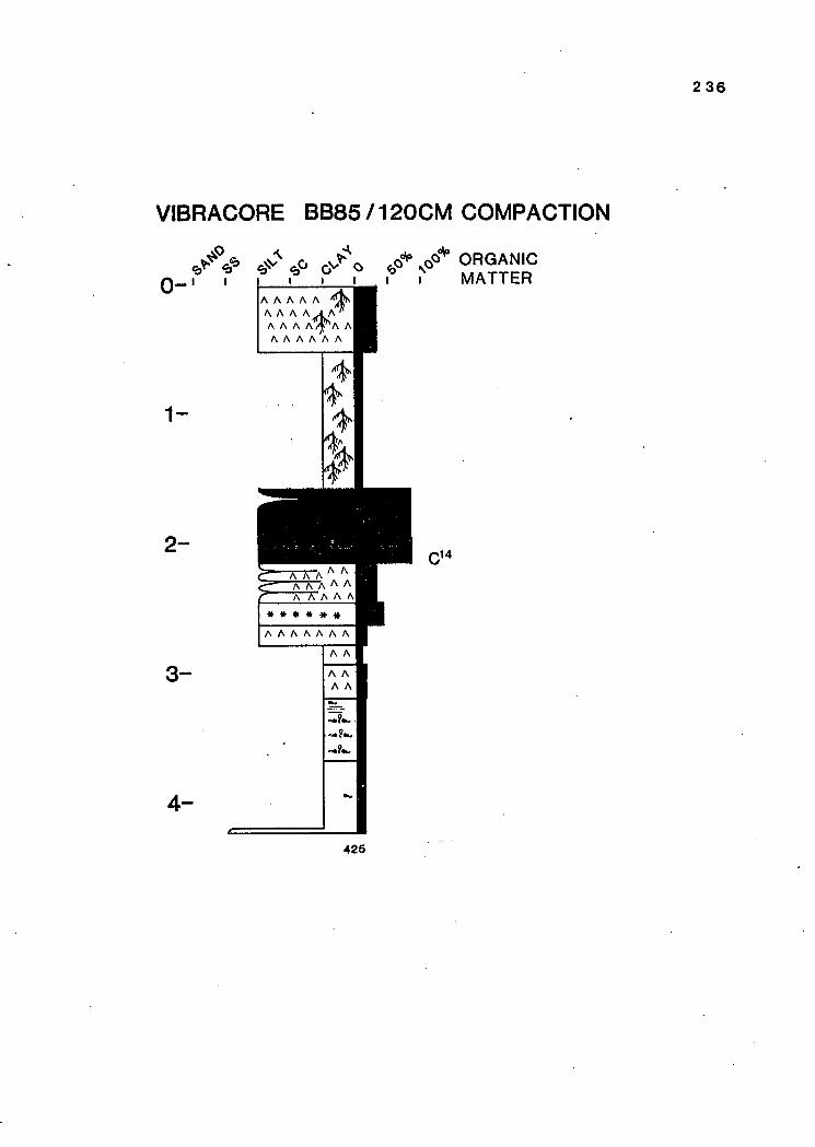
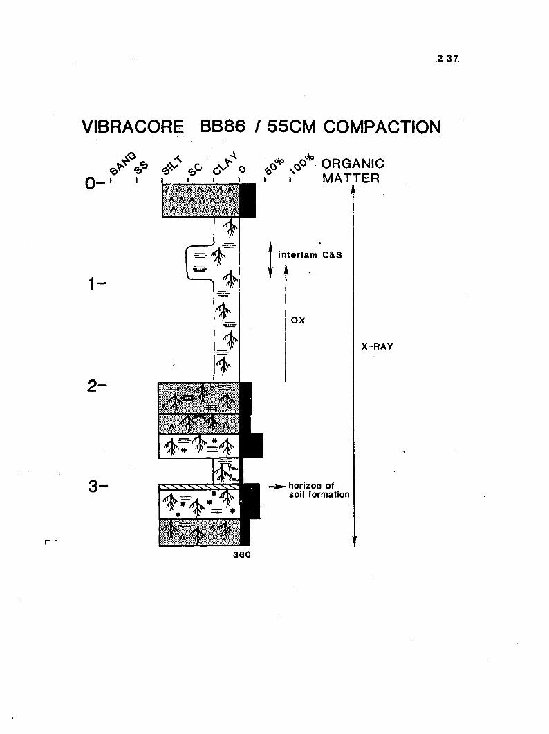


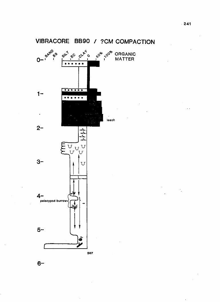
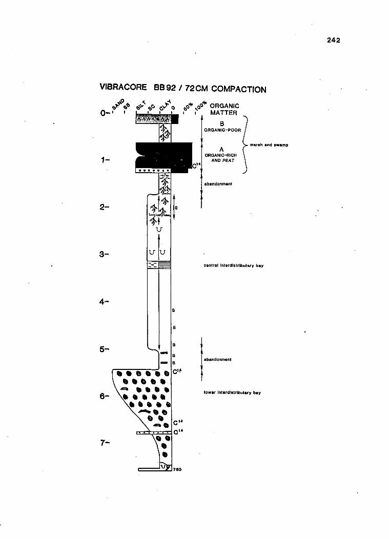

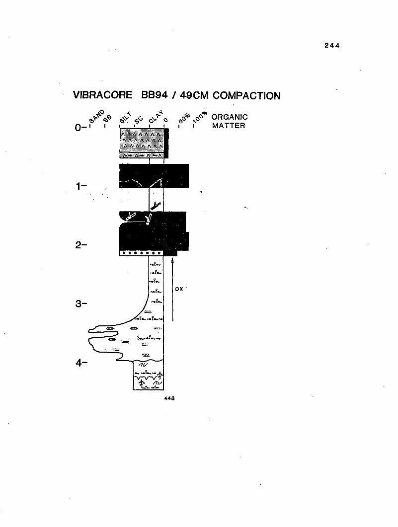


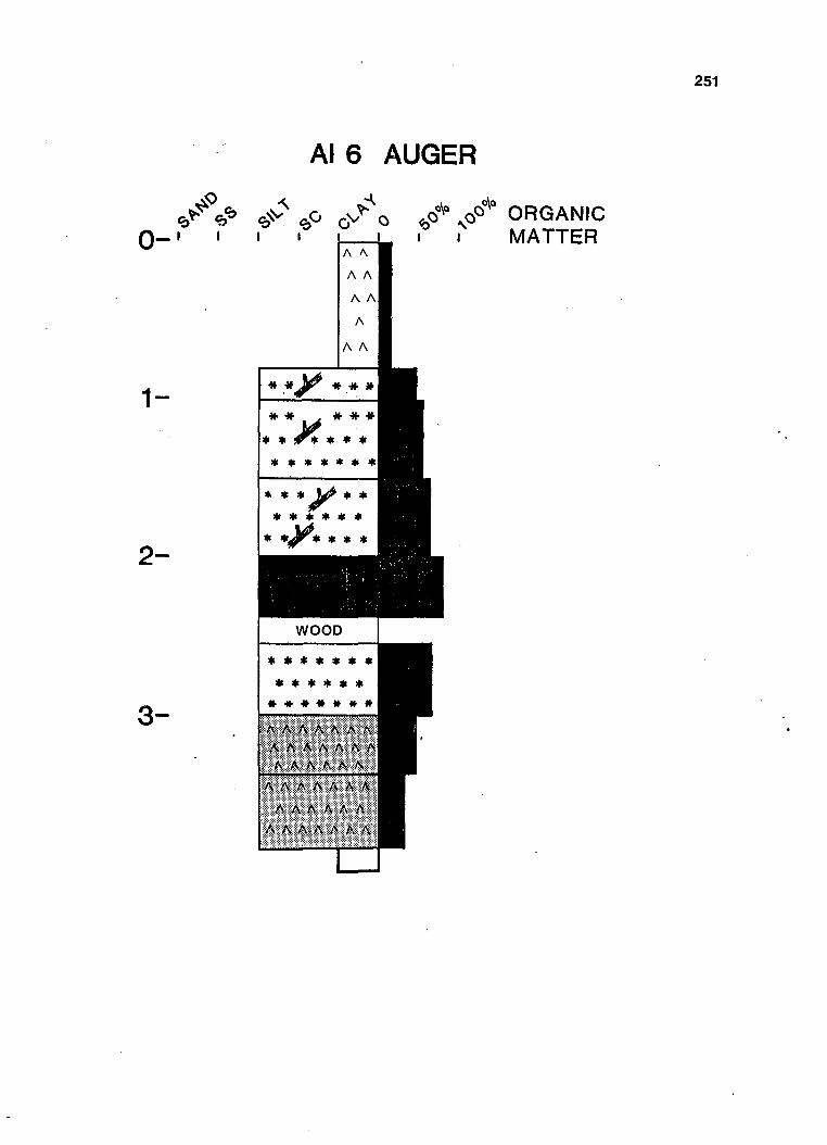

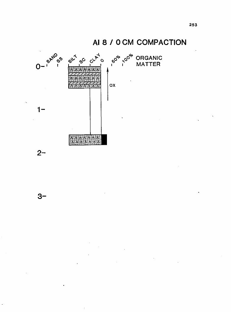


![2012 -2014 Mississippi Delta Cardiovascular Health ...[5] Short VL, Ivory-Walls T, Smith L, Loustalot F. The Mississippi Delta Cardiovascular Health Examination Survey: Study Design](https://static.documents.pub/doc/80x56/5ed5e9584671760b576a7eac/2012-2014-mississippi-delta-cardiovascular-health-5-short-vl-ivory-walls.jpg)


