January 2015 Amendment 4 ASP 60 Gray & Lewis Landuse Planners PART 1 – STATUTORY REPORT Amendment 4 Amendment 4 to Agreed Structure Plan No 60 Lots 1001 & 1002 Marmion Avenue, Alkimos The Amendment to the Agreed Structure Plan is prepared under the provisions of Part 9 of the City of Wanneroo District Planning Scheme No. 2
Transcript
January 2015 Amendment 4 ASP 60 Gray & Lewis Landuse Planners
The Amendment to the Agreed Structure Plan is prepared under the provisions of Part 9 of the City of Wanneroo District Planning Scheme No. 2
PART 1 – STATUTORY REPORT Amendment 3
PART 1 – STATUTORY REPORT Amendment 4
Amendment 4 to Agreed Structure Plan No 60 Lots 1001 & 1002 Marmion Avenue, Alkimos
The Amendment to the Agreed Structure Plan is prepared under the provisions of Part 9 of the City of Wanneroo District Planning Scheme No. 2
January 2015 Amendment 4 ASP 60 Gray & Lewis Landuse Planners
AMENDMENT NO 4
TO
LOT 1001 AND 1002 MARMION AVENUE, ALKIMOS
AGREED STRUCTURE PLAN
AGREED STRUCTURE PLAN NO 60
This Amendment to the Agreed Structure Plan is prepared under the provisions of
Part 9 of the City of Wanneroo District Structure Planning Scheme No 2.
January 2015 Amendment 4 ASP 60 Gray & Lewis Landuse Planners
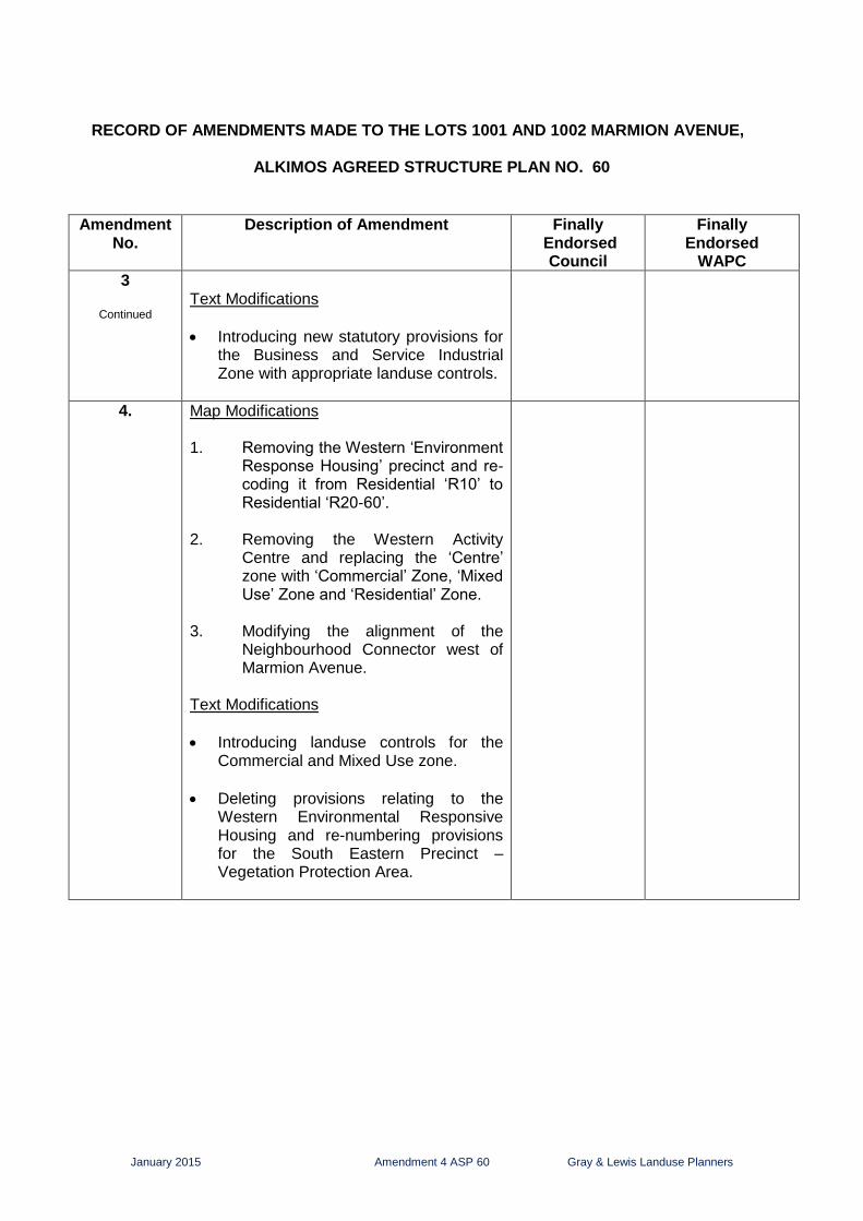
RECORD OF AMENDMENTS MADE TO THE LOTS 1001 AND 1002 MARMION AVENUE,
ALKIMOS AGREED STRUCTURE PLAN NO. 60
Amendment No.
Description of Amendment Finally Endorsed
Council
Finally Endorsed
WAPC
1 Variations to Residential Design Code Provisions for R20 and R25 front loaded lots.
26 May 2011 19 September 2011
2 Realigns the neighbourhood connector road structure in the northern and central parts;
Removes a portion of the ‘Other Regional Road’ reservation for Romeo Road and includes the land in the Residential zone;
Zones an area defined as ‘subject to further planning’ east of the Northern Suburbs Railway as Residential zone; and
Rationalises the boundary between the Centre and Residential zones east of Marmion Avenue.
20 May 2014
(Delegated Authority in accordance with Clause 8.1e of Council’s Delegated Authority Register)
3 Map Modifications
Extending a neighbourhood connector in the northern part.
Zoning the areas defined as ‘subject to further planning’ as described below:
i. An area east of Marmion Avenue
and south of a neighbourhood connector to ‘Residential’ and ‘Business’ zone.
ii. An area south of Romeo Road to
‘Business’ Zone, ‘Residential’ Zone and ‘Service Industrial’ Zone.
iii. An area west of Mitchell Freeway to
Residential zone with extension of ‘environment response housing’ to the east.
Lodged with City of Wanneroo –
being assessed.
January 2015 Amendment 4 ASP 60 Gray & Lewis Landuse Planners
RECORD OF AMENDMENTS MADE TO THE LOTS 1001 AND 1002 MARMION AVENUE,
ALKIMOS AGREED STRUCTURE PLAN NO. 60
Amendment
No. Description of Amendment Finally
Endorsed Council
Finally Endorsed
WAPC
3
Continued
Text Modifications
Introducing new statutory provisions for the Business and Service Industrial Zone with appropriate landuse controls.
4.
Map Modifications 1. Removing the Western ‘Environment
Response Housing’ precinct and re-coding it from Residential ‘R10’ to Residential ‘R20-60’.
2. Removing the Western Activity
Centre and replacing the ‘Centre’ zone with ‘Commercial’ Zone, ‘Mixed Use’ Zone and ‘Residential’ Zone.
3. Modifying the alignment of the
Neighbourhood Connector west of Marmion Avenue.
Text Modifications
Introducing landuse controls for the Commercial and Mixed Use zone.
Deleting provisions relating to the Western Environmental Responsive Housing and re-numbering provisions for the South Eastern Precinct – Vegetation Protection Area.
January 2015 Amendment 4 ASP 60 Gray & Lewis Landuse Planners
AMENDMENT NO 4
TO
LOTS 1001 AND 1002 MARMION AVENUE, ALKIMOS
AGREED STRUCTURE PLAN NO. 60
The City of Wanneroo pursuant to Part 9 of District Planning Scheme No 2, hereby amends the statutory section of the above Agreed Structure Plan by: Map Modifications 1. Removing the Western ‘Environment Response Housing’ precinct and re-
coding it from Residential ‘R10’ to Residential ‘R20-60’. 2. Removing the Western Activity Centre and replacing the ‘Centre’ zone with a
‘Commercial’ Zone, ‘Mixed Use’ Zone and ‘Residential’ Zone. 3. Modifying the alignment of the Neighbourhood Connector west of Marmion
Avenue. Text Modifications
A. 9.0 LAND USE PRECINCTS Eight separate landuse precincts are identified on the structure plan; Precinct 1: Activity Centres – Commercial / Retail, Mixed Use and Higher
Density Residential.
Precinct 2: Residential – Low to Medium Density.
Precinct 3: Environment Responsive Housing.
Precinct 4: Educational and District Open Space.
Precinct 5: Business Zone
Precinct 6: Service Industrial Zone
Precinct 7: Commercial Zone
Precinct 8: Mixed Use Zone B. 9.1 Precinct 1 Activity Centre –Commercial / Retail, Mixed Use
and Higher Density Residential There is one Activity Centre Precinct within the Structure Plan area. The activity centre is located in the heart of the eastern cell at the intersection of two neighbourhood connectors and is known as ‘Agora Village’.
January 2015 Amendment 4 ASP 60 Gray & Lewis Landuse Planners
C. 9.1.1 Objectives:
The objective of the Activity Centre Precinct is to facilitate the creation of a vibrant centre with a diverse mix of uses including commercial and retail activities as well as leisure, health and community services. More intensive housing is also proposed within and around the activity centres. The creation of a strong public realm based upon more intensive urban design with an emphasis on streetscape amenity to enhance the sense of place is also a fundamental objective in the creation of activity centres.
The land included within the Local Structure Plan boundary is located between the proposed District Centre at Jindalee and the proposed Regional (City) Centre at Alkimos. As such, the activity centre within the Structure Plan area will be relatively small and intimate.
D. 9.1.2 Provisions:
Eastern Activity Centre (Agora Village)
The Eastern Activity Centre Precinct is zoned ‘Centre’. A separate Centre (Local) Structure Plan is required for the Activity Centre in accordance with Clause 3.13 of the Scheme. There is an Agreed Local Structure Plan No 86 for the Eastern Activity Centre which was adopted by the City of Wanneroo on the 1 March 2002, and the Western Australian Planning Commission on the 8 May 2012.
Agreed Local Structure Plan No 86 specifies the requirement for the preparation of accompanying Detailed Area Plans to define built form, carparking etc as defined under the provisions of the Scheme.
Retail Floorspace Provision
The retail floorspace provision within the activity centre is identified on Plan 3.
The maximum Retail Net Leasable Area’s (NLA) is as follows;
Eastern Centre 1500m2 NLA
E. 9.3 Precinct 3 Environment Responsive Housing
One area is identified under Precinct 3 for Environment Responsive Housing:
South Eastern Precinct – Vegetation Protection Area.
F. Deleting Clause ‘9.3.1 Western Precinct – Dune Protection Area’ and
associated sub clauses ‘9.3.1.1 Objectives’, ‘9.3.1.2 Provisions’; and re-numbering existing Clause 9.3.2 and sub clauses 9.3.2.1 - 9.3.2.2 to Clause 9.3.1 and sub clauses 9.3.1.1 - 9.3.1.2 respectively as follows:
9.3.1 South Eastern Precinct – Vegetation Protection Area
January 2015 Amendment 4 ASP 60 Gray & Lewis Landuse Planners
9.3.1.1 Objective:
As part of a negotiated agreement with Department of Environment, Water, Heritage and the Arts (DEWHA) through the assessment of the project under the Environmental Protection Biodiversity Conservation Act (EPBC) there was a requirement to protect existing vegetation, primarily Tuart Trees, along a portion of the south eastern boundary of Lots 1001 and 1002. This objective has been satisfied with the identification of the Environment Responsive Housing Precinct – Vegetation Protection Area. The extent of the vegetation protection area comprises a depth of approximately 50-60 metres and length of approximately 620 metres as shown on the Local Structure Plan.
9.3.1.2 Provisions
Land Use Permissibility
Land use permissibility within this Precinct shall be in accordance with Residential zone under the scheme.
Lot Size/Residential Density
The minimum lot size that is permitted within this Precinct is 1,800m2.
Detailed Area Plan
A Detailed Area Plan (DAP) will be required for the Environment Responsive Housing Precinct to address: - Building location and setbacks; - Vegetation Protection zones; - Fencing; - Building Design; - Fire Management; - Retaining walls (rear interface).
G. Inserting a new clause ‘9.7 Precinct 6 Commercial Zone’ and clause ‘9.8
Precinct 7 Mixed Use Zone’ with landuse and retail floorspace controls as follows:
9.7 Precinct 6 Commercial Zone The Commercial zone will provide for a proposed shopping centre and
a wide range of business activities.
Retail Floorspace Provision The maximum Retail Net Leasable Area (NLA) within the combined
area of the Commercial and Mixed Use zone shall not exceed 2600m2
as identified on Plan 3. 9.7.1 Landuse Permissibility: Landuse permissibility within this precinct shall be in accordance with
those contained in the City of Wanneroo District Planning Scheme No 2 for the Commercial Zone.
January 2015 Amendment 4 ASP 60 Gray & Lewis Landuse Planners
9.8 Precinct 7 Mixed Use The Mixed Use zone will cater for a variety of compatible landuses
and provide an intermediate stage between the Residential and Commercial zones.
Retail Floorspace Provision The maximum Retail Net Leasable Area (NLA) within the combined
area of the Commercial and Mixed Use zone shall not exceed 2600m2
as identified on Plan 3. 9.8.1 Landuse Permissibility: Landuse permissibility within this precinct shall be in accordance with
those contained in the City of Wanneroo District Planning Scheme No 2 for the Mixed Use Zone.
27575Res
ROMEO
ROAD
ROMEO ROAD
SU
BU
RB
S
NO
RT
HE
RN
MIT
CH
ELL
RA
ILWA
Y
FR
EE
WA
Y
MA
RM
ION
AV
EN
UE
MA
RM
ION
AV
EN
UE
LAND REQUIREDFOR FREEWAY
NEIG
HBO
UR
HO
OD
CO
NN
EC
TO
R
NEIGHBOURHOOD
NEIG
HBO
UR
HO
OD
NE
IGH
BO
UR
HO
OD
CO
NN
EC
TO
R
CO
NN
EC
TO
R
NEIG
HBO
UR
HO
OD
CO
NN
EC
TO
R
1002
1001
HIGH SCHOOL / PRIMARY SCHOOLAND DISTRICT OPEN SPACE
NE
IGH
BO
UR
HO
OD
CO
NN
EC
TO
R
NEIGHBOURHOOD
CONNECTOR
CONNECTOR
LEGEND
LSP BOUNDARY
PRECINCTS
ENVIRONMENTRESPONSE HOUSING
ACTIVITY CENTRESRetail, Mixed Use & Higher Density Residential)
EDUCATIONAL AND DISTRICTOPEN SPACE
RESIDENTIAL
4 WAY CONTROLLED INTERSECTION
AREA SUBJECT TO MODIFICATION INAMENDMENT No. 3
BUSINESS ZONE
SERVICE INDUSTRIAL
27575Res
ROMEO
ROAD
ROMEO ROAD
SU
BU
RB
S
NO
RT
HE
RN
MIT
CH
ELL
RA
ILWA
Y
FR
EE
WA
Y
MA
RM
ION
AV
EN
UE
MA
RM
ION
AV
EN
UE
LAND REQUIREDFOR FREEWAY
NEIG
HBO
UR
HO
OD
CO
NN
EC
TO
R
NEIG
HBO
UR
HO
OD
NE
IGH
BO
UR
HO
OD
CO
NN
EC
TO
R
CO
NN
EC
TO
R
NEIG
HBO
UR
HO
OD
CO
NN
EC
TO
R
1002
1001
HIGH SCHOOL / PRIMARY SCHOOLAND DISTRICT OPEN SPACE
NE
IGH
BO
UR
HO
OD
CO
NN
EC
TO
R
NEIGHBOURHOOD
CONNECTOR
CONNECTOR
LEGEND
LSP BOUNDARY
PRECINCTS
ENVIRONMENTRESPONSE HOUSING
ACTIVITY CENTRE - Retail, Mixed Use& Higher Density Residential)
EDUCATIONAL AND DISTRICTOPEN SPACE
RESIDENTIAL
4 WAY CONTROLLED INTERSECTION
AREA SUBJECT TO MODIFICATION INAMENDMENT No. 4
BUSINESS ZONE
SERVICE INDUSTRIAL
NEIGHBOURHOOD
LEFT IN - LEFT OUT INTERSECTION
COMMERCIAL
MIXED USE
THE DOCUMENT MAY ONLY BE USED FOR THE PURPOSE FOR WHICH IT WAS COMMISSIONED AND IN ACCORDANCE WITH THE TERMS OF ENGAGEMENT FOR THE COMMISSION. UNAUTHORISED USE OF THIS DOCUMENT IN ANY FORM WHATSOEVER IS PROHIBITED.
* AMENDMENT 3 HAS BEEN LODGED SEPARATELY TO THE CITY OF WANNEROO AND IS SUBJECT TO SEPARATE APPROVAL. AMENDMENT 3 MAPPING HAS BEEN INCLUDED FOR INFORMATION PURPOSES ONLY.
27575Res
LAND REQUIREDFOR FREEWAY
1002
1001
ROMEO
ROAD
ROMEO ROAD
SUBU
RBS
NO
RTH
ERN
MITC
HELL
RA
ILWAY
FREEW
AY
MA
RM
ION
AV
ENU
E
MA
RM
ION
AV
EN
UE
NEIG
HBO
URH
OO
D
CO
NN
EC
TO
R
NEIGHBOURHOOD
NEI
GHBO
URHO
OD
NEIG
HBO
URH
OO
D
CO
NN
ECTO
R
CO
NN
EC
TO
R
NEIG
HBO
URHO
OD
CO
NN
EC
TO
R
NEIG
HBO
URH
OO
DC
ON
NEC
TO
R
NEIGHBOURHO OD
CONNEC TOR
CONNECTOR
LEGEND
ZONES
RESIDENTIAL
NOTES :
PUBLIC USE
PRIMARY REGIONAL ROADS
RESERVATIONS
OTHER REGIONAL ROADS
RAILWAY
1. The maximum Retail NLA for the Eastern Activity Centre
Commercial and Mixed Use zone shall not exceed 2600m
4 WAY CONTROLLED INTERSECTION
LSP BOUNDARY
AREA SUBJECT TO MODIFICATION INAMENDMENT No. 4
BUSINESS ZONE
LEFT IN - LEFT OUT INTERSECTION
HIGH SCHOOL / PRIMARY SCHOOLAND DISTRICT OPEN SPACE
CONNECTOR
NEI
GHBO
URHO
OD
SERVICE INDUSTRIAL
3. No Residential land uses shall be permitted in the Business zone
COMMERCIAL
MIXED USE
ZONE CENTRE ZONE
2
2 shall be 1500m
2. The maximum Retail NLA for the combined area of the 2
27575Res
LAND REQUIREDFOR FREEWAY
1002
1001
ROMEO
ROAD
ROMEO ROAD
SUBU
RBS
NO
RTH
ERN
MITC
HELL
RA
ILWAY
FREEW
AY
MA
RM
ION
AV
ENU
E
MA
RM
ION
AV
EN
UE
NEIG
HBO
URH
OO
D
CO
NN
EC
TO
R
NEIGHBOURHOOD
NEI
GHBO
URHO
OD
NEIG
HBO
URH
OO
D
CO
NN
ECTO
R
CO
NN
EC
TO
RN
EIGHBO
URHO
OD
CO
NN
EC
TO
R
NEIG
HBO
URH
OO
DC
ON
NEC
TO
R
NEIGHBOURHO OD
CONNEC TOR
CONNECTOR
LEGEND
ZONES
RESIDENTIAL
NOTE : MAXIMUM NLA RETAIL
PUBLIC USE
PRIMARY REGIONAL ROADS
RESERVATIONS
OTHER REGIONAL ROADS
RAILWAY
1. To be defined under Centre Zone LSP 2. To be defined under Centre Zone LSP
4 WAY CONTROLLED INTERSECTION
LSP BOUNDARY
AREA SUBJECT TO MODIFICATION INAMENDMENT No. 4
BUSINESS ZONE
LEFT IN - LEFT OUT INTERSECTION
HIGH SCHOOL / PRIMARY SCHOOLAND DISTRICT OPEN SPACE
CONNECTOR
NEI
GHBO
URHO
OD
SERVICE INDUSTRIAL ZONE
3. No residential land uses shall be permitted in the Business Zone
THE DOCUMENT MAY ONLY BE USED FOR THE PURPOSE FOR WHICH IT WAS COMMISSIONED AND IN ACCORDANCE WITH THE TERMS OF ENGAGEMENT FOR THE COMMISSION. UNAUTHORISED USE OF THIS DOCUMENT IN ANY FORM WHATSOEVER IS PROHIBITED.
PROPOSED AMENDMENT 4 TOAGREED LOCAL STRUCTURE PLAN 60
29th JANUARY 2015
PLAN 3 - ZONING PLAN
AGREED LOCAL STRUCTURE PLAN WITH AMENDMENT 3 - PROPOSED ZONING PLAN*
AMENDMENT 4 LOCAL STRUCTURE PLAN - PROPOSED ZONING PLAN
* AMENDMENT 3 HAS BEEN LODGED SEPARATELY TO THE CITY OF WANNEROO AND IS SUBJECT TO SEPARATE APPROVAL. AMENDMENT 3 MAPPING HAS BEEN INCLUDED FOR INFORMATION PURPOSES ONLY.
27575Res
LAND REQUIREDFOR FREEWAY
R10
R10R20 - R60
R20 - R60
R20 - R60
R20 - R60 R20 - R60
R20 - R60
R20 - R60
R20 - R60
R20 - R60
R20 - R60
R40-
R40 - R100R40 - R100
R40 - R100R100
MINIMUM LOT SIZE 1800m²
1002
1001
R40-R100
ROMEO
ROAD
ROMEO ROAD
SUBU
RBS
NO
RTH
ERN
MITC
HELL
RA
ILWAY
FREEW
AY
MA
RM
ION
AV
ENU
E
MA
RM
ION
AV
EN
UE
NEIG
HBO
URH
OO
D
CO
NN
EC
TO
R
NEIGHBOURHOOD
NEI
GHBO
URHO
OD
NEIG
HBO
URH
OO
D
CO
NN
ECTO
R
CO
NN
EC
TO
RN
EIGHBO
URHO
OD
CO
NN
EC
TO
R
NEIG
HBO
URH
OO
DC
ON
NEC
TO
R
NEIGHBOURHO OD
CONNEC TOR
CONNECTOR
LEGEND
LSP BOUNDARY
AREA SUBJECT TO MODIFICATION INAMENDMENT No. 3
R10
R20 - R60
R20 - R60
R20 - R60
NA
NABUSINESS ZONE
NABUSINESS ZONE
BUSINESS ZONE
R40 - R100
NAHIGH SCHOOL / PRIMARY SCHOOL
AND DISTRICT OPEN SPACE
R40 - R100
R40 - R100
R20 - R60 R20 - R60
NASERVICE INDUSTRIAL
ZONE
27575Res
LAND REQUIREDFOR FREEWAY
R20 - R60
R20 - R60
R20 - R60
R20 - R60 R20 - R60
R20 - R60
R20 - R60
R20 - R60
R20 - R60
R20 - R60
R40-
R40 - R100 R40 - R100
R40 - R100
R100
MINIMUM LOT SIZE 1800m²
1002
1001
R40-R100
ROMEO
ROAD
ROMEO ROAD
SUBU
RBS
NO
RTH
ERN
MITC
HELL
RA
ILWAY
FREEW
AY
MA
RM
ION
AV
ENU
E
MA
RM
ION
AV
EN
UE
NEIG
HBO
URH
OO
D
CO
NN
EC
TO
R
NEI
GHBO
URHO
OD
NEIG
HBO
URH
OO
D
CO
NN
ECTO
R
CO
NN
EC
TO
R
NEIG
HBO
URHO
OD
CO
NN
EC
TO
R
NEIG
HBO
URH
OO
DC
ON
NEC
TO
R
NEIGHBOURHO OD
CONNEC TOR
CONNECTOR
LEGEND
LSP BOUNDARY
AREA SUBJECT TO MODIFICATION INAMENDMENT No. 4
R10
R20 - R60
R20 - R60
R20 - R60
NA
NABUSINESS ZONE
NABUSINESS ZONE
BUSINESS ZONE
R40 - R100
NAHIGH SCHOOL / PRIMARY SCHOOL
AND DISTRICT OPEN SPACE
R40 - R100
R40 - R100
R20 - R60 R20 - R60
NASERVICE INDUSTRIAL
ZONE
NEIGHBOURHOOD
R20 - R60
R20 - R60
R40-R100R20-
R60
R20-R60
R20 - R60
THE DOCUMENT MAY ONLY BE USED FOR THE PURPOSE FOR WHICH IT WAS COMMISSIONED AND IN ACCORDANCE WITH THE TERMS OF ENGAGEMENT FOR THE COMMISSION. UNAUTHORISED USE OF THIS DOCUMENT IN ANY FORM WHATSOEVER IS PROHIBITED.
PROPOSED AMENDMENT 4 TOAGREED LOCAL STRUCTURE PLAN
3rd OCTOBER 2014
PLAN 4 - DENSITY CODES
AGREED LOCAL STRUCTURE PLAN WITH AMENDMENT 3 - PROPOSED RESIDENTIAL DENSITY CODE PLAN *
AMENDMENT 4 LOCAL STRUCTURE PLAN - PROPOSED RESIDENTIAL DENSITY CODE PLAN
* AMENDMENT 3 HAS BEEN LODGED SEPARATELY TO THE CITY OF WANNEROO AND IS SUBJECT TO SEPARATE APPROVAL. AMENDMENT 3 MAPPING HAS BEEN INCLUDED FOR INFORMATION PURPOSES ONLY.
January 2015 Amendment 4 ASP 60 Gray & Lewis Landuse Planners
CERTIFIED THAT AMENDMENT NO 4
TO
LOTS 1001 AND 1002 MARMION AVENUE, ALKIMOS
AGREED LOCAL STRUCTURE PLAN No. 60
WAS ADOPTED BY
RESOLUTION OF THE WESTERN AUSTRALIAN PLANNING COMMISSION
ON …………………………………………..
Signed for and on behalf of the Western Australian Planning Commission
…………………………………………..
an officer of the Commission duly authorised by the Commission pursuant to Section 24 of the
Planning and Development Act 2005 for that purpose,
in the presence of:
……………………………………………. Witness
………………………… Date
AND BY
RESOLUTION OF THE COUNCIL OF THE CITY OF WANNEROO
(or as otherwise delegated under Section 8.1 of its Delegated Authority Register)
ON …………………………….
Signed for and on behalf of the City of Wanneroo in accordance with the Local Government Act 1995, Clause 9.49 A. (1) (b)
……………………………………………………….. Director, Planning and Sustainability, City of Wanneroo