hazard areas to the greatest extent possible. The approval authority may allow underground
utility lines within these areas when it is determined that there are no practicable alternatives or if
Attachment B
Attachment B
the utility lines will be consolidated with a road crossing or parallel to an existing utility crossing
at the minimum separation distances established by the county for such uses.
A. Utility corridors. Utility corridor alignment, construction, restoration, and maintenance
shall adhere to the following standards:
1. Utility corridor alignment shall fall outside of geologic hazard areas and
associated buffers to the maximum extent possible where it would have the least
impact on the functions of the geologic hazard area and associated buffers. The
approval authority may require submission of a feasibility study that demonstrates
that alternative routing with less impact on the geologic hazard is not possible.
2. The utility corridor shall have the minimum width practicable.
3. The utility corridor alignment and utility installation shall not cause an increased
risk of landslide or significant erosion that would impact other critical areas or
cause public safety issue.
4. Clearing shall be limited to the minimum necessary to locate the utility. Cutting of
conifer trees greater than 12 inches in diameter (at four and one-half feet above
the ground on the uphill side of the tree) shall be avoided to the maximum extent
possible, consistent with the preservation of important habitats within or adjacent
to the geologic hazard area.
5. The utility corridor shall provide for other necessary uses and facilities whenever
possible. Conduit containing new utilities shall be sized to provide capacity for
additional lines and cables.
6. Utility corridors shall be revegetated with appropriate native vegetation,
compatible with the utility facility and, whenever possible, equivalent to
preconstruction densities. Restoration shall occur immediately upon completion
of construction or soon thereafter under seasonal constraints or work windows
established pursuant to this chapter. The applicant shall submit a performance
surety consistent with chapter 24.70 TCC to ensure that such vegetation survives
or is replaced.
7. Staging areas. Staging areas for equipment and materials shall be located outside
of the geologic hazard area and associated buffers.
8. Maintenance plan. Applicants shall submit a maintenance plan for the corridor for
approval by the county consistent with the provisions of this chapter.
B. Individual utility service lines. Overhead lines or cables serving an individual use are
permitted if no alternative is available, they meet state and federal requirements and do
not impair the functions of the geologic hazard area or associated important habitat area.
Poles supporting such lines shall be located outside of the geologic hazard area when
Attachment B
Attachment B
feasible. If a pole is necessary within the geologic hazard area, it shall be located where it
would be least damaging to the geologic hazard area, as determined by the approval
authority.
Buried service lines serving an individual uses are permitted upon demonstration that
they will not have an adverse impact on the geologic hazard area The site shall be
restored upon completion of the utility installation.
24.15.180 Geologic hazard areas – Vegetation removal – General. Vegetation removal is prohibited in geologic hazard areas and associated buffers except as
A. Class IV Forest Practices Permits and Conversion Option Harvest Plans (COHPs) are
subject to the standards of this Chapter.
B. The harvesting of trees with an approved Class II or Class III forest practices permit is
subject to review and approval by Washington Department of Natural Resources and
shall not be subject to the standards of this Chapter.
C. Harvesting of trees within erosion hazard areas that do not meet the definition of
landslide hazard or marine bluff hazard areas may be permitted. Removal of trees within
an erosion hazard area shall not result in impacts to soil stability. This may require
additional soils or geotechnical reports to evaluate impacts and/or identify mitigation
measures.
24.15.200 Geologic hazard areas – Vegetation removal – Hazard trees.
The approval authority may authorize the limbing, thinning or removal of hazard trees located
within a geologic hazard area or buffer provided that:
A. The approval authority may require the applicant to submit a report from an appropriate
professional(s) (certified arborist, geotechnical engineer, professional forester, etc.) that
documents the hazard. The professional arborist may recommend suitable replacement
trees for any trees removed pursuant to this subsection.
B. Tree cutting is limited to limbing or crown thinning in compliance with National Arborist
Association pruning standards, unless the tree has a disease that would jeopardize the
survival of other trees, or felling the tree is otherwise justified by the landowner/expert to
eliminate hazard trees or to otherwise protect the integrity of the bluff or slope.
C. Trees subject to wind throw that may increase slope instability if they blow down may be
removed, subject to a report from the appropriate professional(s) (e.g., certified arborist,
geotechnical engineer, professional forester, etc.) to confirm that there is a risk of wind
throw and that removal of the tree(s) will not decrease slope stability.
Attachment B
Attachment B
D. The landowner shall replace any tree that is taken down in the buffer. Replacement trees
shall be native, field grown, 15 gallon pot size, a height of four (4) feet, and be three (3)
years old. Larger trees may be required when there are insufficient remaining trees in the
buffer to ensure slope stability and prevent the creation of more hazard trees, as
determined by the approval authority.
E. To ensure survival of replacement trees, replacement shall be at a ratio of 3:1 for each
tree removed. The approval authority may require that the trees be planted from October
to February and that watering, maintenance, and/or monitoring plans be submitted to
ensure their survival. Demarcation and protection of planted trees may be required to
ensure tree survival.
24.15.210 Geologic hazard areas – Vegetation removal – Noxious weeds. Removal of noxious weeds, as defined by chapter 16-750 WAC, under the direction of the
Thurston County Noxious Weed Control Board, is permitted in geologic hazard areas and
associated buffers consistent with a county approved integrated pest management plan,
applicable county and state regulations, any applicable approved farm plan, and this section.
Prior to requiring removal of noxious weeds within a landslide or marine bluff hazard area or
associated buffer that would involve the use of motorized equipment or broadcast spraying of
herbicides, the Noxious Weed Control Board staff shall consult with the Resource Stewardship
Department to evaluate alternative methods of weed removal and the associated risks to the
stability of the landslide or marine bluff hazard area and buffer.
A. Plant removal shall be performed with hand labor, including the use of hand held non-
motorized tools, unless the approval authority determines that the scale of the project
warrants use of small scale motorized equipment (e.g., riding mowers or light
mechanical cultivating equipment) or other method (i.e., application of herbicide in
accordance with state and federal law by a licensed applicator) and use of the
equipment/method does not pose a significant risk to untargeted areas, slope stability, or
habitat functions.
B. Plant removal that would expose more than 500 square feet of soil within a landslide or
marine bluff hazard area or buffer shall require submission of a plan for county approval
that identifies the proposed plant removal and site restoration consistent with the
provisions of this section.
C. Erosion shall be effectively controlled and exposed areas shall be stabilized immediately
following plant removal consistent with the chapter 15.05 TCC. If the area of exposed
soil lies within the landslide or marine bluff hazard area or the buffer, the exposed area
shall be planted with appropriate plant species present in the area at a density that will
provide complete ground cover at maturity, unless the approval authority determines that
the area will revegetate naturally without jeopardizing slope stability or habitat functions.
D. Vegetation removal shall be the minimum extent necessary; and shall not create a public
safety risk.
Attachment B
Attachment B
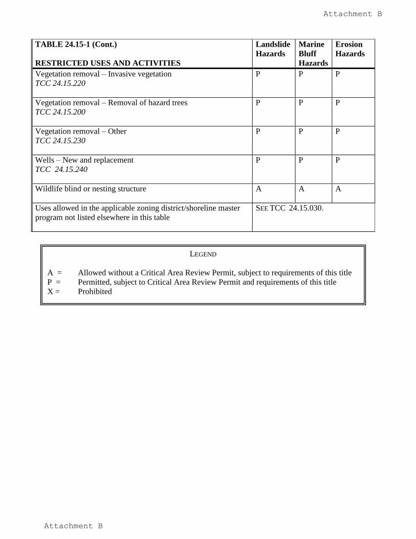
24.15.220 Geologic hazard areas – Vegetation removal – Invasive plants.
Removal of invasive plants
is permitted subject to all of the following:
A. Plant removal shall be performed such that it will not increase the likelihood of erosion or
slope instability within marine bluff or landslide hazard areas and associated buffers,
significantly damage untargeted vegetation, or impair any habitat functions.
B. Plant removal shall be performed with hand labor, including the use of hand held, non-
motorized tools, unless the approval authority determines that the scale of the project
warrants use of small scale motorized equipment (e.g., riding mowers or light
mechanical cultivating equipment) or other method (i.e., application of herbicide in
accordance with state and federal law by a licensed applicator) and use of the
equipment/method does not pose a significant risk to untargeted areas, slope stability, or
habitat functions.
C. Plant removal that would expose more than 500 square feet of soil in a contiguous area
within a landslide or marine bluff hazard area or buffer shall require submission of a plan
for county approval that identifies the proposed plant removal and site restoration
consistent with the provisions of this section.
D. Erosion shall be effectively controlled and exposed areas shall be stabilized immediately
following plant removal consistent with the chapter 15.05 TCC. If the area of exposed
soil lies within the landslide or marine bluff hazard area or the buffer, the exposed area
shall be planted with appropriate plant species present in the area at a density that will
provide complete ground cover at maturity, unless the approval authority determines that
the area will revegetate naturally without jeopardizing slope stability or habitat functions.
24.15.230 Geologic hazard areas – Vegetation removal – Other.
Other vegetation may be removed from the hazard area and associated buffer, as follows:
A. Removal of vegetation to the minimum extent necessary for surveying or testing purposes
is allowed, as determined by the approval authority.
B. Marine Bluff or Landslide Hazard Area. The approval authority may allow the trimming
or limited removal of vegetation to the minimum extent necessary to provide a view
corridor, provided that view corridors are limited to a maximum width of twenty feet.
The trimming of limbs on individual trees is preferred to the removal of trees. Trimming
shall be limited to limbing or crown thinning in compliance with National Arborist
Association pruning standards. Trimming shall not include felling, topping, or removal
of trees, or jeopardizing the tree’s survival. Prior to tree removal, the approval authority
shall require the applicant to submit a report from the appropriate professional(s) (e.g.,
arborist, geotechnical engineer, professional forester, etc) to confirm that removal of the
tree(s) will not increase the hazard.
C. Erosion Hazard Areas. The applicant shall comply with TCC 24.15.090 when removing
vegetation within an erosion hazard area.
Attachment B
Attachment B
D. Other vegetation may be managed by the periodic mowing of previously cleared areas to
maintain pasture vegetation or other vegetation management designed to stabilize the
slope or bluff.
24.15.240 Geologic hazard areas – Wells – New and replacement.
New or replacement wells serving an approved individual use are allowed within geologic
hazard areas and associated buffers, as specified in Table 24.15-1, provided that:
A. There is not minimally sufficient area on the property outside the hazard area and/or
buffer to accommodate the well, as determined by the approval authority; and
B. New on-site wells shall be consistent with the applicable provisions of Articles III of The
Rules and Regulations of the Thurston County Board of Health Governing Water
Supplies; and
C. If a landslide or marine bluff hazard area is present on the site, the approval authority
may require the applicant to demonstrate that the drilling will not destabilize the slope;
and
D. Vegetation removal shall be consistent with this chapter; and
E. Pumphouses, wellhouses and any associated structures shall be located outside of
geologic hazard areas and their associated buffers.
Attachment B
Attachment B
Table 24.15-2--Critical Facilities for Thurston County
Occupancy Category
Nature of Occupancy
IV. Essential
Hospitals and other medical facilities having surgery and emergency treatment areas
Fire, rescue and police stations and other emergency vehicle garages
Water treatment facilities required to maintain water pressure for fire suppression
Designated earthquake, hurricane or other emergency shelters
Designated emergency preparedness, communication, and operation centers and other facilities required for emergency response
Power-generating stations and other public utility facilities required as emergency backup facilities for essential facilities.
Aviation control towers, air traffic control centers, and emergency aircraft hangars
Structures containing sufficient quantities of toxic materials or explosive substances to be dangerous to the safety of the general public if released
Buildings and other structures having critical national defense functions
III. Hazardous
Buildings and other structures where more than 300 people congregate in one area.
Buildings and other structures with elementary school, secondary school, or day care facilities with an occupant load > 250
Buildings and others structures with an occupant load greater > 500 for colleges or adult education facilities
Health care facilities with an occupant load of 50 or more resident patients but not having surgery or emergency treatment facilities
Jails and detention facilities
All structures with occupancy load > 5,000
Power-generating stations, water treatment for potable water, waste water treatment facilities and other public utility facilities not included as an Essential Facility, above
Buildings and other structures not included as an Essential Facility, above, containing sufficient quantities of toxic or explosive substances to be dangerous to the public if released
Attachment B
Attachment B
Table 24.15-3 --Erosion Soils of Thurston County
Soil Survey of Thurston County, 1990
Map Symbol Soil Name Percent Slope Water Erosion Hazard