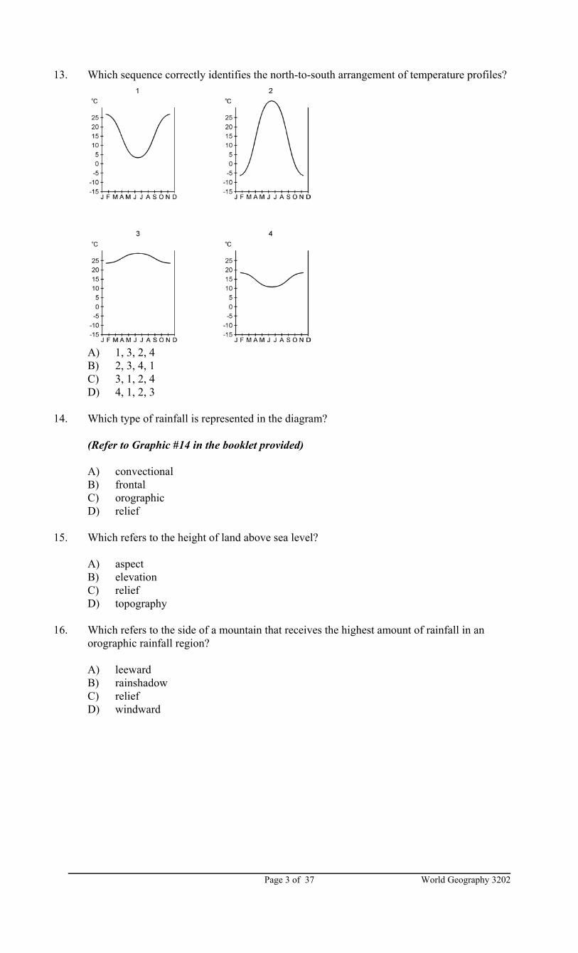
World Geography 3202 Page 1 of 37 PART I SECTION A TOTAL VALUE: 36% Instructions: Shade the letter of the correct answer on the machine scorable answer sheet provided. 1. Which refers to the zone at the Earth’s surface made up of rocks and minerals? A) inner core B) lithosphere C) mantle D) outer core 2. Which creates fold mountains? A) compressional forces B) sea floor spreading C) subduction D) tensional forces 3. Which is an example of chemical weathering? A) formation of green stains on a copper roof B) fracturing of rocks around a campfire C) peeling away of layers from a sandstone monument D) splitting of pavement by tree roots 4. Which features result from continental glaciation? A) cirque, arete B) erratic, drumlin C) hanging valley, medial moraine D) horn, lateral moraine 5. Which refers to an accumulation of finely layered soil deposited by wind in arid regions? A) hamada B) loess C) moraine D) scree 6. According to the map, which sequence represented by the arrow correctly identifies the west-to- east pattern of landforms across southern Africa? (Refer to Graphic #6 in the booklet provided) A) hills, plateaus, mountains, hills, plains B) mountains, hills, plains, hills, plateaus C) plains, hills, plateaus, mountains, hills D) plateaus, mountains, hills, plains, hills
Transcript
World Geography 3202Page 1 of 37
PART ISECTION A
TOTAL VALUE: 36%
Instructions: Shade the letter of the correct answer on the machine scorable answer sheetprovided.
1. Which refers to the zone at the Earth’s surface made up of rocks and minerals?
A) inner coreB) lithosphereC) mantleD) outer core
2. Which creates fold mountains?
A) compressional forcesB) sea floor spreadingC) subductionD) tensional forces
3. Which is an example of chemical weathering?
A) formation of green stains on a copper roofB) fracturing of rocks around a campfireC) peeling away of layers from a sandstone monumentD) splitting of pavement by tree roots
4. Which features result from continental glaciation?
A) cirque, areteB) erratic, drumlinC) hanging valley, medial moraineD) horn, lateral moraine
5. Which refers to an accumulation of finely layered soil deposited by wind in arid regions?
A) hamadaB) loessC) moraineD) scree
6. According to the map, which sequence represented by the arrow correctly identifies the west-to-east pattern of landforms across southern Africa?
(Refer to Graphic #6 in the booklet provided)
A) hills, plateaus, mountains, hills, plainsB) mountains, hills, plains, hills, plateausC) plains, hills, plateaus, mountains, hillsD) plateaus, mountains, hills, plains, hills
World Geography 3202 Page 2 of 37
7. According to the map, which phrase best describes the location of earthquakes on the Earth’ssurface?
(Refer to Graphic #7 in booklet provided)
A) along the northern edges of continentsB) along the edges of plate boundariesC) in the middle of continentsD) in the middle of oceans
8. In the diagram, at what stage in its life cycle is this river?
(Refer to Graphic #8 in the booklet provided)
A) late maturityB) maturityC) old ageD) youth
9. According to the diagram of a drumlin, in which direction did the glacier move?
A) east-to-westB) north-to-southC) south-to-northD) west-to-east
10. Which sequence illustrates the process in the formation of a sea stack?
14. Which type of rainfall is represented in the diagram?
(Refer to Graphic #14 in the booklet provided)
A) convectionalB) frontalC) orographicD) relief
15. Which refers to the height of land above sea level?
A) aspectB) elevationC) reliefD) topography
16. Which refers to the side of a mountain that receives the highest amount of rainfall in anorographic rainfall region?
A) leewardB) rainshadowC) reliefD) windward
World Geography 3202 Page 4 of 37
17. Which diagram best illustrates prevailing wind direction in the Northern Hemisphere?
A) 1B) 2C) 3D) 4
18. According to the diagram, which accounts for differences in east and west coast temperatures inSouth America?
(Refer to Graphic #18 in the booklet provided)
A) impact of northeast winds on east coast and southerly winds on west coastB) impact of northeast winds on west coast and southerly winds on east coastC) influence of warm ocean current on east coast and cold ocean current on west coastD) influence of cold ocean current on east coast and warm ocean current on west coast
19. Which factor gives Novosibirsk a wide range of temperatures from winter to summer?
(Refer to Graphic #19 in the booklet provided)
A) altitudeB) continentalityC) latitudeD) topography
20. Which best describes the climate represented by the climograph below?
A) cool, wet summers and mild, dry wintersB) hot, dry summers and mild, wet wintersC) hot, dry summers with an even distribution of precipitationD) warm, wet summers and cool, dry winters
World Geography 3202Page 5 of 37
21. Which group of simple organisms that live in soil or water and include bacteria, fungi andmolds, obtain their nutrients from dead plant or animal material by breaking it down into basicchemical compounds?
A) consumersB) decomposersC) herbivoresD) producers
22. At which trophic level would you find the fewest number of organisms?
A) 1B) 2C) 3D) 4
23. Which ecosystem experiences low amounts of precipitation and has limited plant life withshallow roots?
A) desertB) temperate deciduous forestC) tropical broadleaf forestD) tundra
24. According to the map, which sequence occurs as one moves south from the equator in SouthAmerica?
(Refer to Graphic #24 in the booklet provided)
A) desert, tropical rainforest, tropical grassland and savanna, temperate grasslandB) tropical grassland and savanna, temperate grassland, desert, tropical rainforestC) tropical rainforest, tropical grassland and savanna, temperate grassland, desertD) temperate grassland, desert, tropical rainforest, tropical grassland and savanna
25. Which item is an input in a potato chip plant?
A) marketingB) potato chipsC) quality controlD) salt
26. Which may be classified as capital-intensive?
A) manufacturing costume jewelleryB) manufacturing subway carsC) producing tourist information brochuresD) selling home insurance
World Geography 3202 Page 6 of 37
Alphabet Toys Ltd produces toys for toddlers as educational aids.
Visitor Charms Ltd produces souvenirs for tourists to illustrate theuniqueness of the local culture.
27. Which would be produced by a market-oriented industry?
A) cod filletsB) lumberC) pure fruit juiceD) soft drinks
28. Which condition would have the least influence on the location of a manufacturing plant?
A) good access to recreational facilitiesB) high availability of capitalC) large pool of skilled labourD) well-developed infrastructure
29. Which provides a public tertiary activity?
A) bankB) hospitalC) insurance companyD) law firm
30. Which type of industry is described in these scenarios?
A) capital-intensiveB) heavyC) lightD) quaternary
31. Which statement best describes the global distribution of the car industry?
(Refer to Graphic #31 in booklet provided)
A) Most plants are located in developed regions.B) Most plants are located in Eastern Europe.C) Most plants are located in North America.D) Most plants are located in the Southern Hemisphere.
32. Which statement describes employment sector change in Great Britain from 1901 to 1998?
33. Which refers to the total value of goods and services in a nation measured over a year,including investment income abroad, minus the income of foreign nationals within the country?
A) employment structuresB) per capita GNPC) gross national productD) standard of living
34. Which country in the table is most developed?
Socio-Economic Indicators for Selected Counties (1997-2000)
Country Per Capita GNP (U.S. Dollars)
Adult Literacy(%)
Infant Deaths (per 1000 births)
Telephones (per person)
ChileJordanNew ZealandVietnam
10 100350017 7001950
95.286.699.093.7
9.3620.366.2830.24
0.170.080.480.03
A) ChileB) JordanC) New ZealandD) Vietnam
35. According to the map which region is most developed?
(Refer to Graphic #35 in the booklet provided)
A) AfricaB) Southeast AsiaC) South AmericaD) Western Europe
36. According to the graphic provided, which statement reflects the relationship between per capitaGNP and infant mortality rate?
(Refer to Graphic #36 in the booklet provided)
A) Countries with high per capita GNPs have low infant mortality rates.B) Countries with high per capita GNPs have high infant mortality rates.C) Countries with low per capita GNPs have low infant mortality rates.D) Levels of per capita GNP do not affect infant mortality rates.
World Geography 3202 Page 8 of 37
PART ISECTION B
Instructions: Do only ONE of the Units in Part I, Section B.
Either: Unit 4 - Resources on the Land (37-44) Value: 8%
Or: Unit 5 - Resources in the Ocean (45-48) Value: 4%
Resources on the Land - Unit 4
37. Which is not a condition necessary for a natural material to be considered a resource?
A) A society must be able to easily trade the material.B) A society must be able to extract and use the material profitably.C) A society must have the technology to extract and use the material.D) A society must need the material.
38. Which process transports insoluble inorganic matter downward through the soil?
A) accumulation of humusB) capillary actionC) eluviationD) leaching
39. Which refers to an input in a farming system?
A) crop rotationB) fertilizerC) harvestingD) storage
40. Which farming practice reduces soil loss?
A) chemical fertilizingB) contour ploughingC) crop rotationD) manuring
41. Which refers to the removal of individual or small groups of mature trees from a forest?
A) clear cuttingB) desertificationC) selective cuttingD) strip cutting
42. Using the triangular graph of soil texture, which combination would make the poorest soil?
We need access to this timber resource. Every effort will be made to use selective-cutting practices and to protect wildlife, but the bottom line is the profitability of thisoperation. What is your priority - jobs or animals?
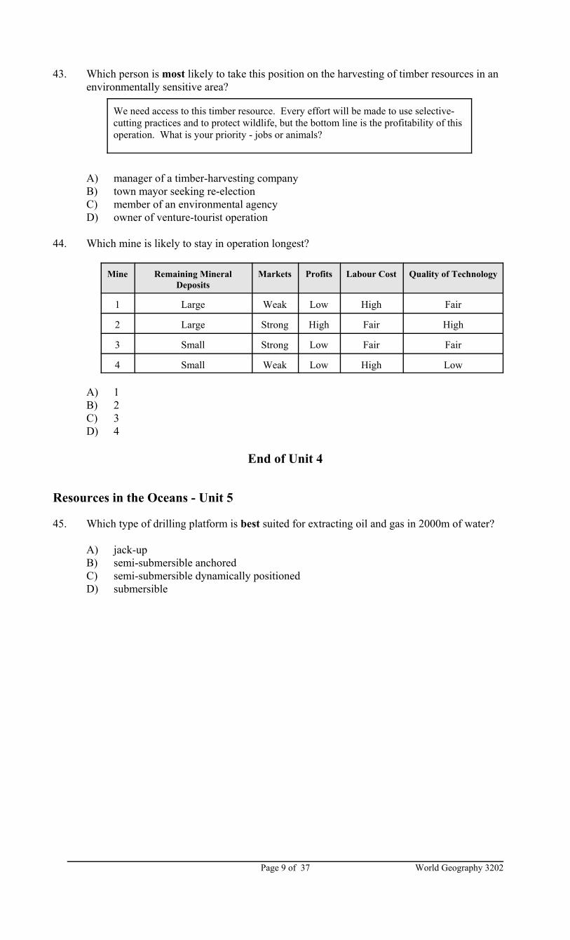
43. Which person is most likely to take this position on the harvesting of timber resources in anenvironmentally sensitive area?
A) manager of a timber-harvesting companyB) town mayor seeking re-electionC) member of an environmental agencyD) owner of venture-tourist operation
44. Which mine is likely to stay in operation longest?
Mine Remaining MineralDeposits
Markets Profits Labour Cost Quality of Technology
1 Large Weak Low High Fair
2 Large Strong High Fair High
3 Small Strong Low Fair Fair
4 Small Weak Low High Low
A) 1B) 2C) 3D) 4
End of Unit 4
Resources in the Oceans - Unit 5
45. Which type of drilling platform is best suited for extracting oil and gas in 2000m of water?
A) jack-upB) semi-submersible anchoredC) semi-submersible dynamically positionedD) submersible
World Geography 3202 Page 10 of 37
Capelin eat shrimp and krill. The favourite food of cod is capelin. Exports of capelin to Asian countries have been steadily increasing overthe past ten years.
Contribution of Primary Activities to Canada’s GNP (1996)
Agriculture 11.9%Fishery 2.2%Forestry 2.7%Mining, Oil, Gas 24.4%
46. According to the table below, which region had to import the largest amount of oil?
Region % of World Oil Demanded (1997)
% of World Needs Supplied (1997)
North America 27 14
Europe 19 9
Pacific 9 1
Russia 6 10
Southeast Asia 17 7
Latin America 8 9
Africa 3 4
Middle East 6 29
Other 5 17
Total 100 100
A) AfricaB) EuropeC) Middle EastD) North America
47. According to the information below what will be the effect of increased capelin exports on themarine food web in Newfoundland waters?
A) Capelin stocks will increase.B) Capelin stocks will remain stable.C) Cod stocks will decrease.D) Shrimp and krill stocks will decrease.
48. According to the table below, which statement best reflects the economic importance of thefishery to Canada’s economy?
A) The fishery contributes the greatest amount to the GNP.B) The fishery contributes the least amount to the GNP.C) The fishery is an unimportant part of the economy.D) The fishery is next to mining, oil and gas in economic importance.
End of Unit 5
World Geography 3202Page 11 of 37
PART ISECTION C
TOTAL VALUE: 8%
Instructions: Do only ONE of the Units in Part I Section C.
Either: Unit 7 - Linkage in Human Interaction (49-56)
Or: Unit 8 - Population (57-64)
Or: Unit 9 - Settlement and Urbanization (65-72)
Linkage in Human Interaction - Unit 7
49. Which refers to the means by which information is exchanged?
A) communication linkageB) journey chainC) nodeD) transportation linkage
50. Which is an example of an overhead cost for a truck transport operation?
A) drivers’ wagesB) fuel consumptionC) office rentD) truck repairs
51. Which aspect of overall network efficiency is obtained by counting the number of pathsbetween each pair of nodes?
A) accessibilityB) connectivityC) journey chainD) line-haul cost
52. Which occurs when specialization in the production of a good or service in one areacorresponds to a shortage of the same good or service in another area?
A) accessibilityB) connectivityC) supply-demand matchD) transferability
53. Which is not a transportation node?
A) airportB) railway junctionC) road tunnelD) seaport
World Geography 3202 Page 12 of 37
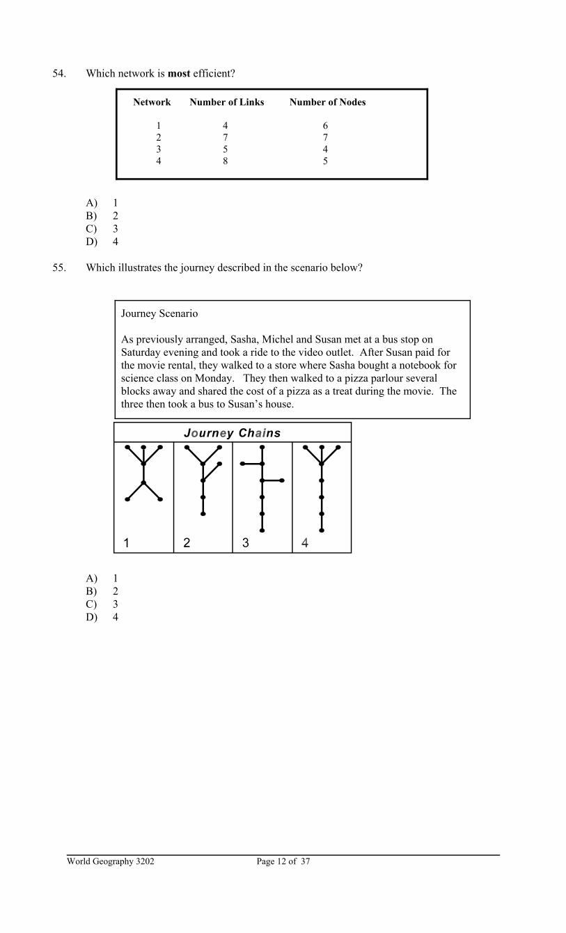
Network Number of Links Number of Nodes
1 4 62 7 73 5 44 8 5
Journey Scenario
As previously arranged, Sasha, Michel and Susan met at a bus stop onSaturday evening and took a ride to the video outlet. After Susan paid forthe movie rental, they walked to a store where Sasha bought a notebook forscience class on Monday. They then walked to a pizza parlour severalblocks away and shared the cost of a pizza as a treat during the movie. Thethree then took a bus to Susan’s house.
54. Which network is most efficient?
A) 1B) 2C) 3D) 4
55. Which illustrates the journey described in the scenario below?
A) 1B) 2C) 3D) 4
World Geography 3202Page 13 of 37
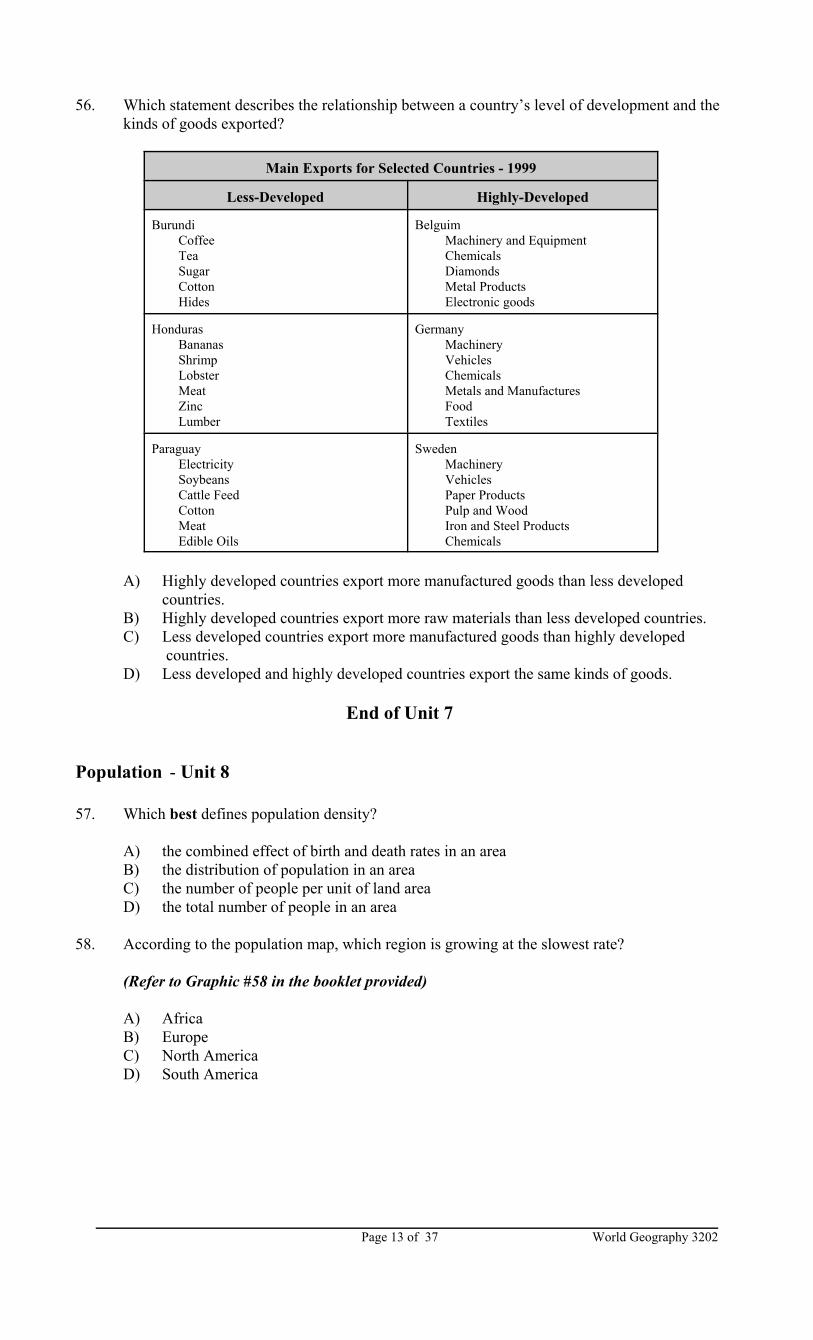
56. Which statement describes the relationship between a country’s level of development and thekinds of goods exported?
Main Exports for Selected Countries - 1999
Less-Developed Highly-Developed
Burundi Coffee Tea Sugar Cotton Hides
Belguim Machinery and Equipment Chemicals Diamonds Metal Products Electronic goods
Honduras Bananas Shrimp Lobster Meat Zinc Lumber
Germany Machinery Vehicles Chemicals Metals and Manufactures Food Textiles
Sweden Machinery Vehicles Paper Products Pulp and Wood Iron and Steel Products Chemicals
A) Highly developed countries export more manufactured goods than less developed countries.
B) Highly developed countries export more raw materials than less developed countries.C) Less developed countries export more manufactured goods than highly developed
countries.D) Less developed and highly developed countries export the same kinds of goods.
End of Unit 7
Population - Unit 8
57. Which best defines population density?
A) the combined effect of birth and death rates in an areaB) the distribution of population in an areaC) the number of people per unit of land areaD) the total number of people in an area
58. According to the population map, which region is growing at the slowest rate?
(Refer to Graphic #58 in the booklet provided)
A) AfricaB) EuropeC) North AmericaD) South America
World Geography 3202 Page 14 of 37
59. In a given year, there were 562 034 live births and 498 551 deaths. Which term refers to thechange in population?
A) actual changeB) natural decreaseC) natural increaseD) zero population growth
60. In the 1990s, about 30 000 people left Canada per year. Which term refers to thisphenomenon?
A) emigrationB) immigrationC) internal migrationD) population increase
61. According to Canada’s immigration policy, into which category of immigrants would a self-employed person be classified?
A) familyB) independentC) refugeeD) seasonal workers
62. Which region is most heavily populated?
(Refer to Graphic #62 in the booklet provided)
A) cold northern regions of Canada and AsiaB) hot arid regions in the low latitudesC) hot humid regions in the low latitudesD) temperate regions in the middle latitudes
63. What type of population is indicated by the population pyramid below?
A) contractingB) expandingC) increasingD) stationary
World Geography 3202Page 15 of 37
64. In which country will pull factors be strongest?
Country Births/1000 Life Expectancy(yrs.)
Per Capita GNP(U.S. dollars)
Adult Literacy(%)
DenmarkEgyptHondurasMexico
12.624.931.922.8
76.763.769.471.8
25,5003,6002,7009,100
100.051.472.789.6
A) DenmarkB) EgyptC) HondurasD) Mexico
End of Unit 8
Settlement and Urbanization - Unit 9
65. Which describes the pattern of early rural settlements in which security, companionship andconvenience were important?
A) compactB) compositeC) linearD) loose-knit
66. Which refers to the settlement site illustrated in the diagram?
(Refer to Graphic # 66 in booklet provided)
A) confluence siteB) peninsula siteC) river-island siteD) river meander site
67. Which refers to an increasing proportion of a population residing in towns?
A) migrationB) rural depopulationC) urban sprawlD) urbanization
68. Which describes the arrangement of city sizes as seen in the chart?
City Size
1 876 451
2 439 202
3 294 078
4 212 871
A) arithmetic progressionB) logarithmic progressionC) primacyD) rank-size
World Geography 3202 Page 16 of 37
69. In which urban area would relatively low priced single dwellings be located?
A) central business districtB) industrial zoneC) recreational zoneD) residential zone
70. According to the table below, what is the relationship between the size of a community andthe services offered?
Town Population Banks Dentists Supermarkets Rest. LawOffices
CraftShops
TotalServices
1 136 000 14 22 13 19 11 10 89
2 95 000 9 11 10 13 7 5 55
3 63 000 6 8 9 7 4 4 38
4 22 000 2 3 3 5 3 2 18
5 9500 1 2 3 1 1 8
6 4500 2 2 1 5
7 2500 1 1 2
A) Large communities offer a limited variety of services.B) Small communities offer a large number of services.C) Small communities offer a wide variety of services.D) The size of a community affects the number and kinds of services offered.
71. According to the table below, which region will experience the highest urban populationgrowth from 1950-2030?
Percentage Urban
1950 1975 2000 2030
North America 64 74 77 84
Latin America and Caribbean 41 61 75 83
Europe 52 67 75 83
Oceania 62 72 70 74
Africa 15 25 38 55
Asia 17 25 37 53
World 30 38 47 60
A) AfricaB) AsiaC) Latin America and CarribeanD) North America
World Geography 3202Page 17 of 37
72. According to the indicators in the table below, which city has the highest quality of life?
QUALITY OF LIFE IN SELECTED LARGE CITIES
City Population (in millions)
Murders (per 100 000)
Persons(perroom)
% of houses withwater/electricity
Telephones(per 100people)
Infant deaths(per 100 livebirths)
Tokyo 28.7 1.4 0.9 100 44 5
MexicoCity
19.4 27.8 1.9 94 6 36
Moscow 13.2 7.0 1.3 100 39 20
Mumbai 12.8 101 3.0 57 2 46
A) Mexico CityB) MoscowC) MumbaiD) Tokyo
End of Unit 9
World Geography 3202 Page 18 of 37
Some Amazon Facts
• From August 1998 to August 1999, 19 836 square kilometres of rainforest wereremoved.
• Development, farming, and logging have already reduced the Amazon rainforest by12%.
• One-quarter of medicines come from plants. Three-quarters of these plants comefrom rainforests in the Amazon and Africa.
• When Europeans first arrived in the 16th century, there were about 6 million nativepeoples in the Amazon. So many have died from European attacks and westernillnesses, there are now only an estimated 200 000 left.
PART IISECTION A
TOTAL VALUE: 30%
Instructions: Do All questions in this Section.
CASE STUDY 1: The Vanishing Rainforests (73 -76)
Nearly one-half of the world’s rainforests are located in the Amazon Basin of South America.Until recently, only small groups of native people lived there and successfully hunted, fished,collected nuts and berries, and grew crops on small patches of land cleared in the forest.
Since the 1950s, a number of government actions have attracted people from the heavilypopulated coast into the basin’s interior. In 1956, the new capital of Brasilia was established andtoday has a population of nearly 2 million. The government of Brazil provided free land, seeds,and small grants to any coastal farmer who would move inland to farm. Roads were built intothe interior to encourage mining companies to explore for minerals and start mines. Many cattleranches have started up in the region and timber companies have moved in to harvest trees.
Farmers and cattle ranchers soon found the rainforest ecosystem to be unforgiving. Once broadexpanses of trees are removed, the soil is exposed to heavy rains. Nutrients are washed out ofthe soil quickly making them infertile. As a result, they cannot support crops and grass for cattle.The destruction of trees also disrupts food webs so seriously that some species of plants, animals,and insects are becoming extinct. Some scientists even see a global threat. Trees “breathe in”carbon dioxide and “breathe out” oxygen. The massive removal of forest cover could harm lifeforms on the whole planet.
Native peoples of rainforest regions have assisted medical researchers to identify hundreds ofplants that can treat diseases. For example, a drug made from the periwinkle, a rainforest plant,helps 90% of leukemia patients to survive. A protein from the rubber tree will help reduce toothdecay.
World Geography 3202Page 19 of 37
Answer the following questions:
Value 2 73. Why is it appropriate to refer to the rainforest as the “lungs of the earth”?
3 74. Develop an argument against the Brazilian government’s encouragement of settlement inthe Amazon Basin.
3 75. Explain what your position is on the following statement.
Climate, rather than human activity, is the main cause of environmental problems in the Amazon rainforest.
World Geography 3202 Page 20 of 37
Value 4 76. Chand Saklani lives in a small village in India. He was so concerned about the removal
of trees from a hillside near his village that he wrote a poem to express his feelings. Hereis a verse from the poem.
Trees are my mother, trees are my father,Trees are my brothers and sisters, trees are my children.Trees are my family.
Do you think this verse could apply to the rainforests of the Amazon Basin? Explain whyor why not.
World Geography 3202Page 21 of 37
Development Indicators: Nepal and Canada
Indicator Nepal Canada
Labour Force by Sector Farming 41% 3% Industry 3% 31% Services 16% 66%
Per Capita GNP $1360 $24800Infant Mortality Rate 74.14
5.02 (Deaths per 1000 births)People for each telephone 106 1.7Life expectancy 58.22yrs. 79.6 yrs.
CASE STUDY 2: Tourism in Nepal (77 - 79)
The tourism sector is fast nearing the number one position in terms of size and importance tothe global economy. It is estimated that in 2000, there were about 500 million tourists whocontributed nearly 12% to the global Gross Domestic Product. About 8 out of every 100workers were employed in the tourist sector.
The real importance of tourism is best seen when one looks at the economy of selectedcountries. In less developed countries there are limited opportunities to get meaningfulemployment and improve living conditions. In countries such as Cuba, Thailand, Kenya,
and Jamaica, tourism is growing in importance as a way of creating direct jobs and as a wayof improving the overall economy through indirect employment. This is particularly true inNepal, a tiny Himalayan country north of India.
In 1999, the United Nations classified Nepal as one of the five poorest nations in the world. Tourism creates over 100 000 jobs in the country and makes up nearly 4% of its GrossNational Product.
Nepal has a lot to offer the tourist. For the mountaineer, the region has 8 of the 10 highestpeaks in the world, including Mt. Everest. Hiking trails, which lace through jungles and thelow foothills, offer opportunities to spot rhinos, elephants, snow leopards, and tigers. In all, itis estimated that there are 6000 species of plants, 850 species of birds, 600 species ofbutterflies, and 175 species of mammals.
World Geography 3202 Page 22 of 37
In 1970, only 46 000 tourists visited Nepal, but this figure had increased to nearly 500 000 by2000. In the short-term, the government would like to see at least 1 million tourists per year. What will be the environmental impact of such numbers?
Already, there are signs of a deteriorating environment. At the base camp used to make theascent on Mt. Everest, broken pop and beer bottles and other trash are strewn among therhododendron trees. In a first major cleanup, 30 000kg of trash were taken out. There areplans now to conduct a yearly cleanup of the base camp. The fragile ecosystem is threatenedin another way. At high altitudes, vegetation grows very slowly and any damaged plant lifealong hiking trails only repairs itself over decades.
To help clean up the environment and protect the ecosystem, the Nepalese government nowrequire tourists to pay for entry permit to visit parks and conservation areas, and hiking feesto enter the trail system.
Why Tourists Come to Nepal (by %)
1980 1990 1996
Holidays/PleasureTrekking and MountaineeringBusinessOfficialOthers
80.211.83.42.91.7
63.515.74.610.45.8
53.222.66.45.112.7
Questions 77 - 79 are based on the above Case Study.
Value 4 77. Identify and explain two reasons why tourism is so important to less developed
countries such as Nepal.
World Geography 3202Page 23 of 37
Value 3 78. With reference to the case study, explain what type of site conditions Nepal is known
for.
Value 3 79. If you were to give advice to the Nepalese government on how to increase the numbers
of tourists, what advice would you give? Support your position with examples.
World Geography 3202 Page 24 of 37
Access to Safe Water
Region % with access
Africa 62%Asia 81%Latin America 85%Oceania 88%Europe 96%
Access to Proper Sanitation
Region % with access
Africa 60%Asia 40%Latin America 78%Oceania 93%Europe 92%
A Young Girl in Ethiopia
Elma Kassa is a 13-year old who tells about her experience in getting water for her motherwho is a washerwoman in Addis Ababa, Ethiopia.
I go to collect water four times a day, in a 20-litre clay jar. It’s hard work! When Ifirst started collecting water I was about seven years old. In those days we used tohave to walk for over 1.5 kilometres to fetch water. Now there is a tapstand about 10minutes away from my home, which has made life easier. I’ve never been to schoolas I have to help my mother with her washing work so we can earn enough money.
- From DFID (1998), Guidance Manual on Water and Sanitation Programmes, DFID, London
CASE STUDY 3: Water and Development (81- 83)
It is a fact that water is essential to all life. During the mid-1990s, however, more than abillion people in the developing world did not have access to safe water and nearly 2 billionpeople were not provided acceptable sanitation.
Each person needs about 20 litres of safe water a day for drinking, personal hygiene, andhousehold use. Without adequate safe water, nearly 1 billion suffer from various illnessesand about 2 million deaths occur.
World Population and Access to Water (mid-1990s)
A lack of water can weaken the economy. A population that cannot get sufficient quantities ofwater is a less healthy and a less productive one. In developing countries, unclean water has tobe boiled to make it safe. To do this, trees have to be used for fuel, which damages theenvironment. Without sufficient water, farming and manufacturing outputs decrease. In manyrural areas in developing countries, water is not available at a community well nor piped to thehome. Considerable time is spent, particularly by women and children, in carrying water fromstreams and wells to the home and collecting wood to boil it for safe drinking. The 5 to 7 hoursoften spent each day uses up time that could be used getting an education and skills for theworkplace.
World Geography 3202Page 25 of 37
Value 2 80. What is the central issue in this case study?
2 81. List two pieces of evidence to support the issue you identified.
2 82. Explain two measures which could be taken to help correct the problem identified in thiscase study.
World Geography 3202 Page 26 of 37
Value
4 83. Using specific examples, explain why “per capita GNP” is not always a reliable indicator of standard of living.
World Geography 3202Page 27 of 37
PART IISECTION B
Instructions: Do only ONE of the Units in Part II Section B.
Either: Unit 4 - Resources on the Land (84 - 86) Value: 8%
Or: Unit 5 - Resources in the Oceans (87 - 90) Value: 12%
Candidates are reminded that they must choose the same Unit as Part 1 Section B.
Resources on the Land - Unit 4
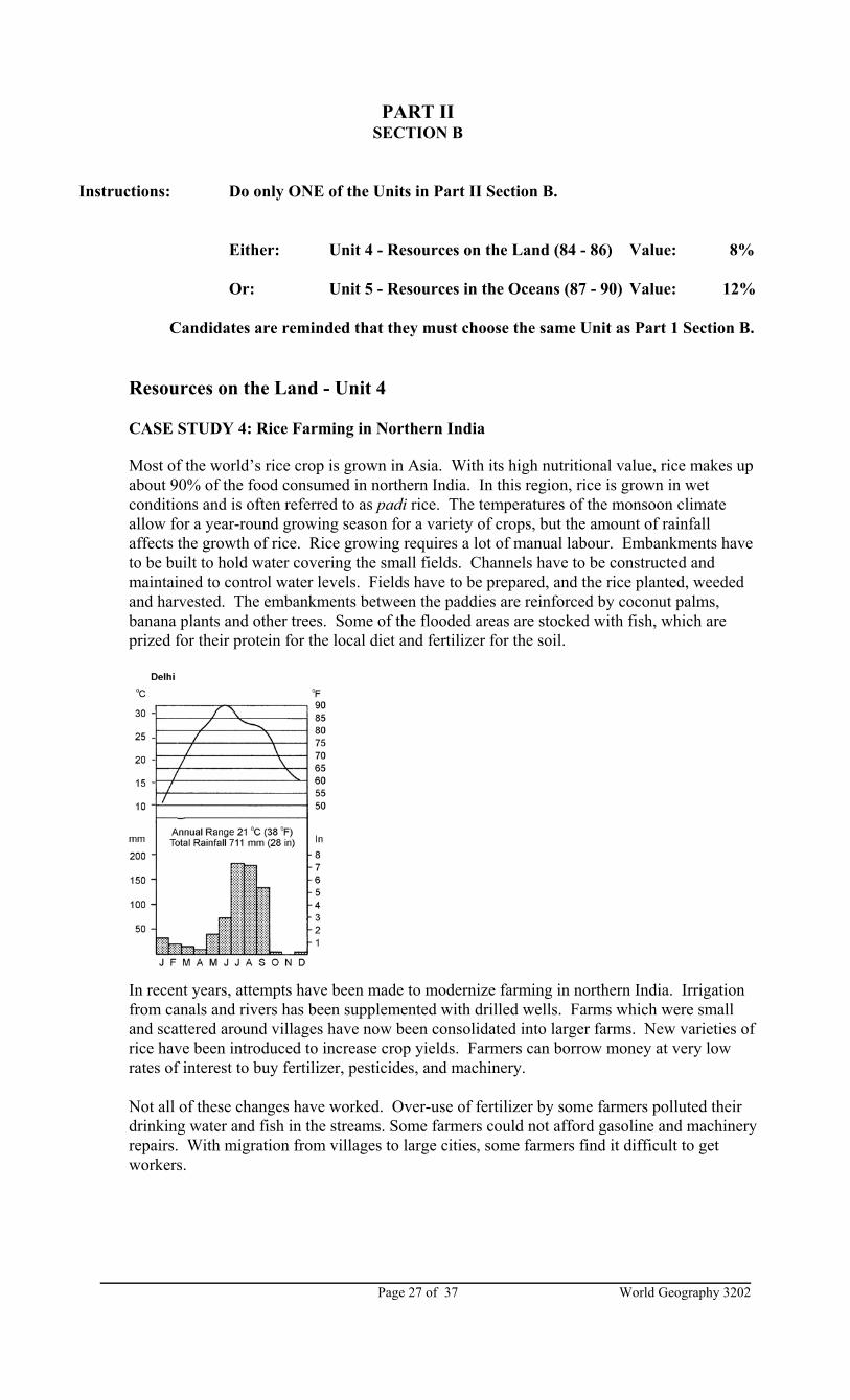
CASE STUDY 4: Rice Farming in Northern India
Most of the world’s rice crop is grown in Asia. With its high nutritional value, rice makes upabout 90% of the food consumed in northern India. In this region, rice is grown in wetconditions and is often referred to as padi rice. The temperatures of the monsoon climateallow for a year-round growing season for a variety of crops, but the amount of rainfallaffects the growth of rice. Rice growing requires a lot of manual labour. Embankments haveto be built to hold water covering the small fields. Channels have to be constructed andmaintained to control water levels. Fields have to be prepared, and the rice planted, weededand harvested. The embankments between the paddies are reinforced by coconut palms,banana plants and other trees. Some of the flooded areas are stocked with fish, which areprized for their protein for the local diet and fertilizer for the soil.
In recent years, attempts have been made to modernize farming in northern India. Irrigationfrom canals and rivers has been supplemented with drilled wells. Farms which were smalland scattered around villages have now been consolidated into larger farms. New varieties ofrice have been introduced to increase crop yields. Farmers can borrow money at very lowrates of interest to buy fertilizer, pesticides, and machinery.
Not all of these changes have worked. Over-use of fertilizer by some farmers polluted theirdrinking water and fish in the streams. Some farmers could not afford gasoline and machineryrepairs. With migration from villages to large cities, some farmers find it difficult to getworkers.
World Geography 3202 Page 28 of 37
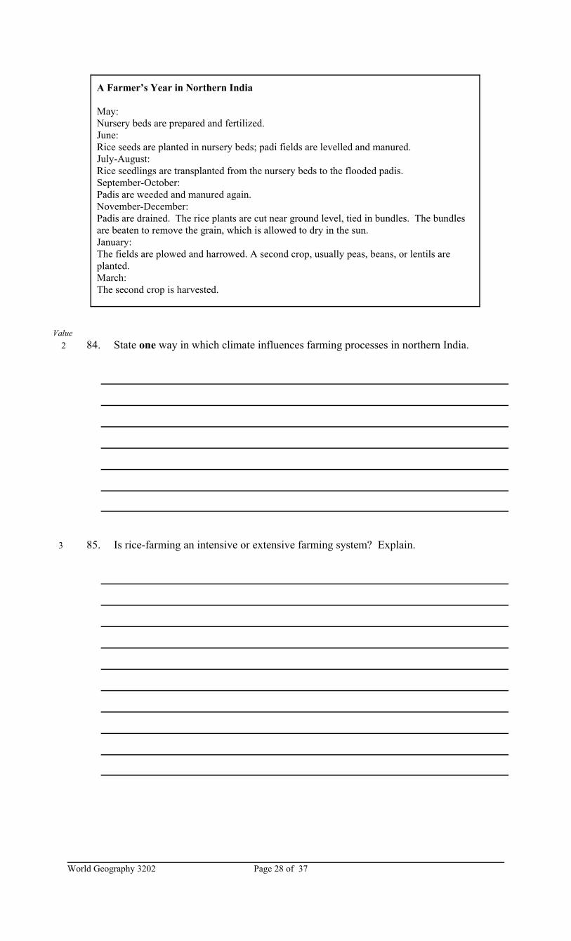
A Farmer’s Year in Northern India
May: Nursery beds are prepared and fertilized.June: Rice seeds are planted in nursery beds; padi fields are levelled and manured.July-August:Rice seedlings are transplanted from the nursery beds to the flooded padis.September-October:Padis are weeded and manured again.November-December:Padis are drained. The rice plants are cut near ground level, tied in bundles. The bundlesare beaten to remove the grain, which is allowed to dry in the sun.January:The fields are plowed and harrowed. A second crop, usually peas, beans, or lentils areplanted.March:The second crop is harvested.
Value 2 84. State one way in which climate influences farming processes in northern India.
3 85. Is rice-farming an intensive or extensive farming system? Explain.
World Geography 3202Page 29 of 37
Value
3 86. Based on the experiences in northern India, what kind of advice could be given tofarmers who are considering new approaches to farming? Provide examples in youranswer.
World Geography 3202 Page 30 of 37
Resources in the Oceans - Unit 5
CASE STUDY 5: Dismantling Offshore Fixed Platforms
Most people think that an offshore drilling rig only poses a threat to the environment as it pumpsoil from under the sea bed. What happens to a fixed rig when a field no longer has anyrecoverable oil also has to be considered. This will be a serious issue in the removal of aplatform, such as Hibernia, that rests on the ocean bottom. Semi-submersible rigs, such as theone used for the Terra Nova field, can be easily moved to another location when that field isexhausted.
International regulations now require oil companies to remove the upper part of a fixed rig to adepth of 55m to leave the bottom part resting on the ocean floor. The upper portion can betransported ashore, or be buried in deeper water. The process of dismantling a rig, however, willpose concerns for the fishing industry. The separation of parts of fixed platforms requires theuse of large amounts of explosives. Although experts in the oil industry do not have muchexperience to go on, they do know that underwater explosions have a short term impact on fish.It is calculated that a 2.5t charge, for example, could kill as much as 20t of fish. The real impactdepends upon the depth of the water, number of fish in the area, and the relief of the oceanbottom. As well, more younger fish will be destroyed than older fish.
In addition to the environmental risk of dismantling a platform, environmentalists would alsohave concerns with problems posed by the bottom sections and the pipelines left on the oceanfloor. Since it is difficult to completely clean them of oil, they could continue to contaminatethe marine environment for many years. As well, they could cause problems for the fishingindustry. Nets and other gear used to trawl the ocean bottom would be heavily damaged if theyshould snag on abandoned underwater structures and pipelines.
On the other hand, marine biologists do agree that the abandonment of bottom portions ofdrilling platforms will likely have a positive effect. These structures act as artificial reefs thatattract invertebrates and fish searching for food and shelter as well as provide places toreproduce. In the Gulf of Mexico, the abandonment of underwater structures have increased fishstocks. As a result, sports fishing activity, with the use of lines and hooks, have taken off. Thequestion, of course, is whether this effect will be as positive off the coast of Newfoundland andLabrador. Here, the ecosystem is much different, and fishers would use mobile gear (i.e., trawls)rather than static gear (i.e., hooks and lines). As a result, trawling practices would have to becarried out at greater distances from the underwater drilling structures and the fishers would nothave good access to the fish stocks.
Value 2 87. Why does a semi-submersible rig have an advantage over a fixed platform when an oil
field is permanently shut down?
World Geography 3202Page 31 of 37
Value 3 88. How is the dismantling of a fixed drilling platform an issue of balancing short-term and
long-term impacts?
3 89. Assume that a government official was to argue that the dismantling of an oil platformwould have a positive impact on the fishery of Newfoundland and Labrador. Whatcautionary arguments would you give?
4 90. Explain two reasons why waters over continental shelves are natural habitats for fish.
World Geography 3202 Page 32 of 37
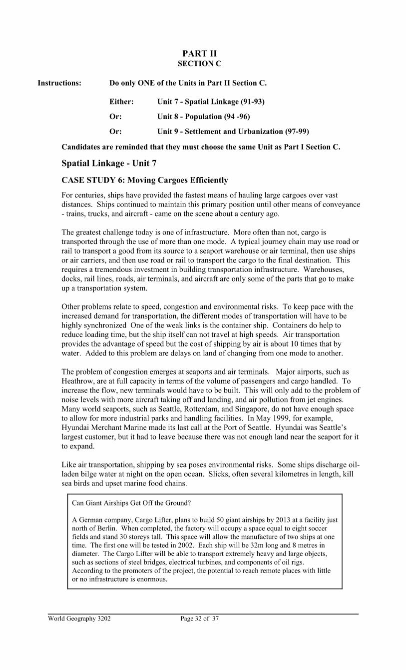
Can Giant Airships Get Off the Ground?
A German company, Cargo Lifter, plans to build 50 giant airships by 2013 at a facility justnorth of Berlin. When completed, the factory will occupy a space equal to eight soccerfields and stand 30 storeys tall. This space will allow the manufacture of two ships at onetime. The first one will be tested in 2002. Each ship will be 32m long and 8 metres indiameter. The Cargo Lifter will be able to transport extremely heavy and large objects,such as sections of steel bridges, electrical turbines, and components of oil rigs. According to the promoters of the project, the potential to reach remote places with littleor no infrastructure is enormous.
PART IISECTION C
Instructions: Do only ONE of the Units in Part II Section C.
Either: Unit 7 - Spatial Linkage (91-93)
Or: Unit 8 - Population (94 -96)
Or: Unit 9 - Settlement and Urbanization (97-99)
Candidates are reminded that they must choose the same Unit as Part I Section C.
Spatial Linkage - Unit 7
CASE STUDY 6: Moving Cargoes Efficiently
For centuries, ships have provided the fastest means of hauling large cargoes over vastdistances. Ships continued to maintain this primary position until other means of conveyance- trains, trucks, and aircraft - came on the scene about a century ago.
The greatest challenge today is one of infrastructure. More often than not, cargo istransported through the use of more than one mode. A typical journey chain may use road orrail to transport a good from its source to a seaport warehouse or air terminal, then use shipsor air carriers, and then use road or rail to transport the cargo to the final destination. Thisrequires a tremendous investment in building transportation infrastructure. Warehouses,docks, rail lines, roads, air terminals, and aircraft are only some of the parts that go to makeup a transportation system.
Other problems relate to speed, congestion and environmental risks. To keep pace with theincreased demand for transportation, the different modes of transportation will have to behighly synchronized One of the weak links is the container ship. Containers do help toreduce loading time, but the ship itself can not travel at high speeds. Air transportationprovides the advantage of speed but the cost of shipping by air is about 10 times that bywater. Added to this problem are delays on land of changing from one mode to another.
The problem of congestion emerges at seaports and air terminals. Major airports, such asHeathrow, are at full capacity in terms of the volume of passengers and cargo handled. Toincrease the flow, new terminals would have to be built. This will only add to the problem ofnoise levels with more aircraft taking off and landing, and air pollution from jet engines. Many world seaports, such as Seattle, Rotterdam, and Singapore, do not have enough spaceto allow for more industrial parks and handling facilities. In May 1999, for example,Hyundai Merchant Marine made its last call at the Port of Seattle. Hyundai was Seattle’slargest customer, but it had to leave because there was not enough land near the seaport for itto expand.
Like air transportation, shipping by sea poses environmental risks. Some ships discharge oil-laden bilge water at night on the open ocean. Slicks, often several kilometres in length, killsea birds and upset marine food chains.
World Geography 3202Page 33 of 37
Value 2 91. What is a major advantage and a major disadvantage of transportation by sea?
3 92. Suggest three strategies that transportation experts should include in their plans for
making transportation more efficient.
3 93. Based on the information in this case study, do you think that planners should take theidea of huge air ships seriously? Explain why or why not.
World Geography 3202 Page 34 of 37
Just to maintain the present worker-pensioner ratio ...
Japan needs 600 000 immigrants per yearItaly needs 350 000Great Britain needs nearly 90 000Germany needs 470 000The United States needs 340 000
Population - Unit 8
CASE STUDY 7: Immigrants Needed
United Nations population experts predict that the early 21st century will mark the beginningof a time when there will be more old people than young. Ten percent of the world’spopulation is already 60 years of age and older. By 2050, this share will increase to 20% andby 2150 over 30%. The real contrasts are among regions. For example 20% of Europeans,compared to only 5% of Africans, are 60 years and over.
Added to that trend, many regions will experience declines in population. On a global scale,according to Austrian experts, the present population of just over 6 billion will likely peak at9 billion by 2070 and decrease to 8.4 billion by 2100. Italy will have 25% fewer people by2050. By the same year, the population of 15 countries in the European Union will drop from375 million to 330 million. There will be fewer British, French, Germans, Japanese, andRussians whose fertility rate of 1.2 children per woman cannot replace those who die.
These trends will have a major economic impact. As the population gets older, governmentswill have to pay a larger share of their budgets in the form of pensions to seniors. The cost ofmedical services will also increase as more and more seniors need medical attention. Thesecosts will rise as the size of the working force shrinks. The size of the labour force willworsen until serious labour shortages become commonplace.
The problem of a shrinking and ageing population could become a crisis in the westernworld. Is there a solution in sight? The real solution would be an increase in the birth rate. Encouraging those who are nearing retirement to continue working to an older age would alsohelp the economy. Others argue that an immediate solution is to admit more immigrantsfrom countries where the problem of a greying and declining population will occur muchlater than in the West. Admitting skilled people of working age would help to reduce thedependency ratio.
World Geography 3202Page 35 of 37
Value 2 94. State the central issue discussed in this case study.
3 95. How could this issue become a crisis for developed nations?
3 96. Explain three actions that western governments could take to help avoid this loomingcrisis.
World Geography 3202 Page 36 of 37
Settlement and Urbanization - Unit 9
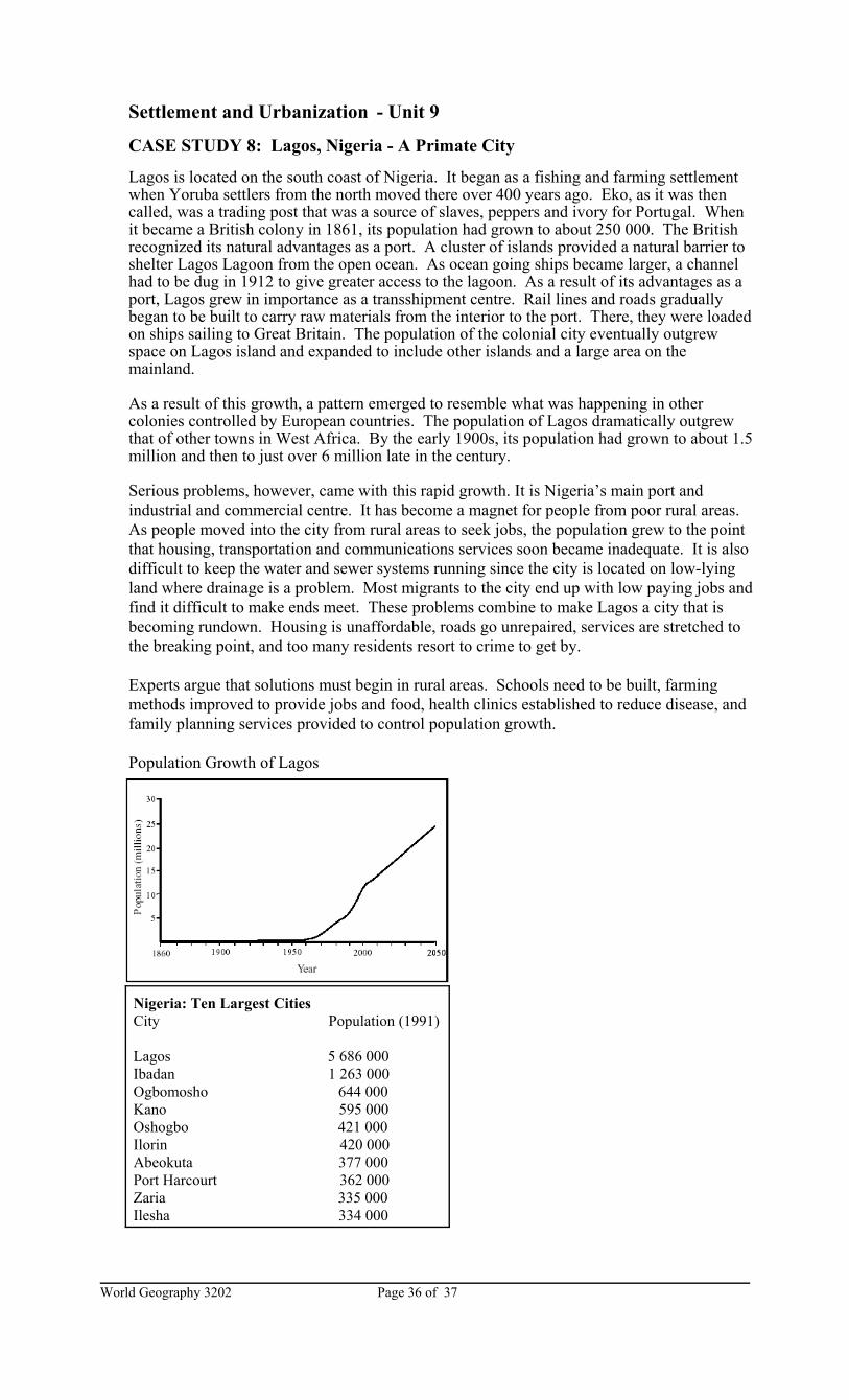
CASE STUDY 8: Lagos, Nigeria - A Primate City
Lagos is located on the south coast of Nigeria. It began as a fishing and farming settlementwhen Yoruba settlers from the north moved there over 400 years ago. Eko, as it was thencalled, was a trading post that was a source of slaves, peppers and ivory for Portugal. Whenit became a British colony in 1861, its population had grown to about 250 000. The Britishrecognized its natural advantages as a port. A cluster of islands provided a natural barrier toshelter Lagos Lagoon from the open ocean. As ocean going ships became larger, a channelhad to be dug in 1912 to give greater access to the lagoon. As a result of its advantages as aport, Lagos grew in importance as a transshipment centre. Rail lines and roads graduallybegan to be built to carry raw materials from the interior to the port. There, they were loadedon ships sailing to Great Britain. The population of the colonial city eventually outgrewspace on Lagos island and expanded to include other islands and a large area on themainland.
As a result of this growth, a pattern emerged to resemble what was happening in othercolonies controlled by European countries. The population of Lagos dramatically outgrewthat of other towns in West Africa. By the early 1900s, its population had grown to about 1.5million and then to just over 6 million late in the century.
Serious problems, however, came with this rapid growth. It is Nigeria’s main port andindustrial and commercial centre. It has become a magnet for people from poor rural areas. As people moved into the city from rural areas to seek jobs, the population grew to the pointthat housing, transportation and communications services soon became inadequate. It is alsodifficult to keep the water and sewer systems running since the city is located on low-lyingland where drainage is a problem. Most migrants to the city end up with low paying jobs andfind it difficult to make ends meet. These problems combine to make Lagos a city that isbecoming rundown. Housing is unaffordable, roads go unrepaired, services are stretched tothe breaking point, and too many residents resort to crime to get by.
Experts argue that solutions must begin in rural areas. Schools need to be built, farmingmethods improved to provide jobs and food, health clinics established to reduce disease, andfamily planning services provided to control population growth.