55
North East Baldivis Structure Plan Lots 460 – 463 Baldivis Road, Baldivis PR115795-1 2017 Page 7 Part Two – Explanatory Report
North East Baldivis Structure Plan Lots 460 – 463 Baldivis Road, Baldivis
PR115795-1 2017 Page 7
Part Two – Explanatory Report

North East Baldivis Structure Plan Lots 460 – 463 Baldivis Road, Baldivis
PR115795-1 2017 Page 8
1.0 Planning Background
1.1 Introduction and Purpose
This Structure Plan hereinafter referred to as the North East Baldivis Structure Plan (NEBSP) has been prepared on behalf of Upside Property Pty Ltd and Woodbrooke Property Pty Ltd which are wholly owned subsidiaries of Cedar Woods Properties Limited.
The purpose of the NEBSP is to facilitate the orderly future subdivision and development of the subject site, and to provide a range of housing types and densities to satisfy the demand for residential housing within the locality.
In addition to the planning considerations canvassed within this report, the preparation of this structure plan has been informed by a number of technical and design investigations, which are referred to in this report and the accompanying technical appendices.
This structure plan has been prepared in accordance with the design requirements outlined in Liveable Neighbourhoods, and responds to requirements outlined in the City of Rockingham Town Planning Scheme No 2 (TPS 2).
The format of this structure plan follows that set out in the Western Australian Planning Commission’s (WAPC) Structure Plan Framework (August 2015), consisting of three parts:
Part 1: Implementation Section: Contains the Structure Plan Map and outlines the requirements that will be applied when assessing subdivision and development applications.
Part 2: Explanatory Section: Discusses the key outcomes and planning implications of the background and technical reports and describes the broad vision and more detailed planning framework being proposed. Part 2 is based on a detailed site specific analysis of opportunities and constraints and the following technical reports and strategies:
- Environmental Assessment Report (RPS);
- Bushfire Management Plan (RUIC Fire);
- Local Water Management Strategy & Addendum (RPS);
- Transport Assessment & Addendum (Cardno);
- Engineering Infrastructure Report (TABEC); and
- Landscape Master Plan (Plan E).
Part 3: Technical Appendices: Includes the technical reports and supporting plans and maps prepared by the project team to support the structure plan.
1.2 Land Description
1.2.1 Location and area
The subject site is situated approximately 9 kilometres (km) south-east of the Rockingham City Centre, and 42 km south of the Perth Central Business District in the locality of Baldivis (refer Figure 1).

North East Baldivis Structure Plan Lots 460 – 463 Baldivis Road, Baldivis
PR115795-1 2017 Page 9
The combined total land area of the parent lots comprised within the subject site is 67.82 hectares, however due to a portion of Lots 462 and 463 Baldivis Road areas being excluded from the structure plan for the purpose of future transfer into the MRS Primary Regional Road Reservation, the total structure plan area (subject site) is 59.5394 hectares.
1.2.2 Land use
The following land uses are contemplated within the structure plan area:
Residential comprising densities which range from R25 to R40
Commercial
Primary School
Public Open Space
Wetland and wetland buffer
Road reserves
The subject site is comprised of predominantly cleared paddocks some of which remain completely unused, or used for horse grazing and agistment. The historical use of the subject site has been principally for agriculture and broad-scale farming.
The properties to the north of the subject site on the opposite side of Pug Road share a similar current and historical land use.
A clay quarry is situated at Lot 1 Mundijong Road to the east of the subject site, separated by the Kwinana Freeway.
A sand quarry is situated at Lot 1355 Baldivis Road to the west of the subject site, separated by the Baldivis Tramway Reserve and Baldivis Road.
A limestone and sand quarry is situated at Lot 800 Kerosene Lane and Lot 2170 Millar Road to the west of the subject site and is also separated by the Baldivis Tramway Reserve and Baldivis Road.
A cemetery operated by the Metropolitan Cemeteries Board, and referred to as Rockingham Memorial Park is situated to the south of the limestone and sand quarry.
The Kwinana Freeway abuts the subject site to the east and Mundijong Road abuts the subject site to the south beyond the portion of Lot 463 that has been excluded from the structure plan boundary for future roads.
1.2.3 Legal Description and Ownership
The subject site is comprised of four individual landholdings owned by two separate entities which are wholly owned subsidiaries of Cedar Woods Properties Ltd. These landholdings are formally described as follows:
North East Baldivis Structure Plan Lots 460 – 463 Baldivis Road, Baldivis
PR115795-1 2017 Page 10
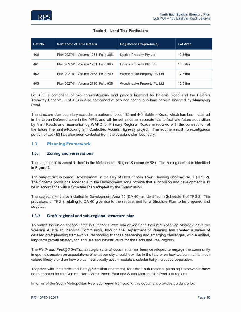
Table 4 – Land Title Particulars
Lot No. Certificate of Title Details Registered Proprietor(s) Lot Area
460 Plan 202741, Volume 1251, Folio 396 Upside Property Pty Ltd 19.56ha
461 Plan 202741, Volume 1251, Folio 396 Upside Property Pty Ltd 18.62ha
462 Plan 202741, Volume 2158, Folio 269 Woodbrooke Property Pty Ltd 17.61ha
463 Plan 202741, Volume 2169, Folio 935 Woodbrooke Property Pty Ltd 12.03ha
Lot 460 is comprised of two non-contiguous land parcels bisected by Baldivis Road and the Baldivis Tramway Reserve. Lot 463 is also comprised of two non-contiguous land parcels bisected by Mundijong Road.
The structure plan boundary excludes a portion of Lots 462 and 463 Baldivis Road, which has been retained in the Urban Deferred zone in the MRS, and will be set aside as separate lots to facilitate future acquisition by Main Roads and reservation by WAPC for Primary Regional Roads associated with the construction of the future Fremantle-Rockingham Controlled Access Highway project. The southernmost non-contiguous portion of Lot 463 has also been excluded from the structure plan boundary.
1.3 Planning Framework
1.3.1 Zoning and reservations
The subject site is zoned ‘Urban’ in the Metropolitan Region Scheme (MRS). The zoning context is identified in Figure 2.
The subject site is zoned ‘Development’ in the City of Rockingham Town Planning Scheme No. 2 (TPS 2). The Scheme provisions applicable to the Development zone provide that subdivision and development is to be in accordance with a Structure Plan adopted by the Commission.
The subject site is also included in Development Area 40 (DA 40) as identified in Schedule 9 of TPS 2. The provisions of TPS 2 relating to DA 40 give rise to the requirement for a Structure Plan to be prepared and adopted.
1.3.2 Draft regional and sub-regional structure plan
To realise the vision encapsulated in Directions 2031 and beyond and the State Planning Strategy 2050, the Western Australian Planning Commission, through the Department of Planning has created a series of detailed draft planning frameworks, responding to those deepening and emerging challenges, with a unified, long-term growth strategy for land use and infrastructure for the Perth and Peel regions.
The Perth and [email protected] strategic suite of documents has been developed to engage the community in open discussion on expectations of what our city should look like in the future, on how we can maintain our valued lifestyle and on how we can realistically accommodate a substantially increased population.
Together with the Perth and [email protected] document, four draft sub-regional planning frameworks have been adopted for the Central, North-West, North-East and South Metropolitan Peel sub-regions.
In terms of the South Metropolitan Peel sub-region framework, this document provides guidance for:

North East Baldivis Structure Plan Lots 460 – 463 Baldivis Road, Baldivis
PR115795-1 2017 Page 11
the preparation of amendments to the Perth metropolitan and Peel region schemes, local planning strategies/schemes and district, local and activity centre structure plans; and
the staging and sequencing of urban development to inform public investment in regional community, social and service infrastructure.
The subject site has been the subject of a recent zoning change in the MRS to transfer the land into the Urban zone. The South Metropolitan Peel sub-regional framework document is reflective of the current zoning in the MRS and this factor is also reflected in the staging and sequencing of future urban development specifically to the south of the subject site in localities beyond Baldivis within the City of Rockingham.
1.3.3 Planning strategies
1.3.3.1 Directions 2031
Directions 2031 is the current spatial planning framework for Perth and Peel, and outlines the planning vision and direction which will guide the planning of the region to 2031.
The Strategy recognises the benefits of a more consolidated city, which includes;
A reduced overall need for travel via private vehicle;
Supports the use of public transport, cycling and walking for access to services, facilities and employment; and
A more energy efficient urban form.
The Strategy aims to provide for different lifestyle choices, vibrant nodes for economic and social activity and a more sustainable urban transport network. A key component of the strategy is to increase the gross residential densities in greenfield areas and to provide for greater housing diversity, which are items specifically relevant to the Structure Plan.
Directions 2031 seeks a 50% increase in the current average residential density of 10 dwellings per gross urban zoned hectare in new development areas i.e. 15 dwellings per gross urban zoned hectare of land. The Structure Plan provides for residential densities well in excess of this target minimum.
Endorsement of the proposed Structure Plan will facilitate subdivision and development of the subject site and assist in meeting the objectives established under Directions 2031. The proposed densities outlined in the Structure Plan will assist in meeting the increase in density requirements as per Directions 2031.
1.3.4 State planning policies
The following State Planning Policies and operational policy are noted as being specifically relevant to the orderly planning of the structure plan area.
1.3.4.1 Liveable Neighbourhoods
The Western Australian Planning Commission’s (WAPC) Liveable Neighbourhoods Policy is intended to guide the subdivision and development of land in Western Australia. The key principles of this policy include:
Providing a variety of lots sizes and housing types to cater for the diverse housing needs of the community at a density that can ultimately support the provision of local services;
To ensure cost-effective and resource efficient development to promote affordable housing; and
To maximise land efficiency.

North East Baldivis Structure Plan Lots 460 – 463 Baldivis Road, Baldivis
PR115795-1 2017 Page 12
Liveable Neighbourhoods provides guidance for the design and development of greenfield subdivision through eight design elements; community design, movement networks, lot layout, public parkland, urban water management, utilities, activity centres and employment, and schools. These various elements have been considered in the preparation of the NEBSP, and are discussed as appropriate in later sections of this report.
1.3.4.2 State Planning Policy No. 2.1 – Peel Harvey Coastal Plain Catchment
The objectives of Statement of Planning Policy (SPP) 2.1 reflect the environmental objectives of the Peel–Harvey EPP and aim to ensure that changes to land use within the catchment are controlled to avoid and minimise environmental damage.
The SPP contains a number of general and specific policy provisions relating to drainage. The policy states that subdivision proposals shall make provision for a drainage system that maximises the consumption and retention of drainage on site. Biological wetland filters or other means of drainage water retention or treatment approved by the EPA are to be incorporated into drainage designs, possibly by amendment of the soils in drainage basins or by the provision of wetland filters with nutrient-retentive soil amendments.
1.3.4.3 State Planning Policy No. 3 – Urban Growth and Settlement
This Policy sets out the principles and considerations which apply to the planning of urban growth settlements in Western Australia. The Policy aims to facilitate sustainable patterns of urban growth and settlement and recognises that the State is undergoing rapid growth and change which is expected to continue. The policy acknowledges that the spread of urban development intensifies pressures on valuable land and water resources, imposes costs for the provision of infrastructure and services, increases dependence on private cars and creates potential inequities for those living in the outer suburbs where job opportunities and services are not so readily available.
The following summary of policy objectives and corresponding NEBSP response to each is provided below.
Table 5 – SPP No.3 Policy Objectives and Structure Plan Response
SPP No.3 Objective NEBSP Response
To promote a sustainable and well planned pattern of settlement with sufficient and suitable land to provide for a wide variety of housing, employment, recreation facilities and open space.
The Structure Plan provides for a wide variety of housing densities and typologies having regard to the nearby proximity of the Structure Plan area to the Baldivis District Centre and Wellard Railway Station.
To build on existing communities with established local and regional economies, concentrate investment on the improvement of services and infrastructure and enhance the quality of life in those communities.
The subject site is located within an existing identified urban development area earmarked for urban subdivision and development. Being located in the South Western corridor of the Perth metropolitan area, planning and development of the land makes best use of existing infrastructure already present in the locality (e.g. utilities, transport infrastructure).
To manage the growth and development of urban areas in response to the social and economic needs of the community and in recognition of relevant climatic, environmental, heritage and community values and constraints.
Economic needs of the community have been established through district level Structure Planning for the locality.
To promote the development of a sustainable and liveable neighbourhood form which reduces energy, water and travel demand whilst ensuring safe and convenient access to employment and services by all modes, provides choice and
The proposed Structure Plan layout seeks to maximise energy efficient and climate responsive design by ensuring all lots can be provided in a north-south or east-west configuration. Sustainable urban water management principles have been applied to the treatment of stormwater and design of Public Open Space. Travel demand will be reduced through the provision of local employment and services, and a permeable

North East Baldivis Structure Plan Lots 460 – 463 Baldivis Road, Baldivis
PR115795-1 2017 Page 13
SPP No.3 Objective NEBSP Response
affordability of housing and creates an identifiable sense of place for each community.
local movement network that encourages walking and cycling.
To coordinate new development with the efficient, economic and timely provision of infrastructure and services.
Development within the Structure Plan will be coordinated with the Urban zoned area to the west which contains established infrastructure and utility services that will be extended to service the structure plan area.
1.3.4.4 SPP 5.4 – Road and Rail Transport Noise and Freight Considerations in Land Use Planning
The objectives in the Policy are to:
Protect people from unreasonable levels of transport noise by establishing a standardised set of criteria to be used in the assessment of proposals;
Protect major transport corridors and freight operations from incompatible urban encroachment;
Encourage best practice design and construction standards for new development proposals and new or redevelopment transport infrastructure proposals;
Facilitate the development and operation of an efficient freight network; and
Facilitate the strategic co-location of freight handling facilities.
1.3.4.5 SPP 3.7 – Planning in Bushfire Prone Areas
The objectives of this Policy are to:
Facilitate the avoidance of placing people, property and infrastructure in areas of extreme bushfire risk;
Reduce vulnerability to bushfire through the identification and assessment of bushfire hazards and risk in decisions at all stages of the planning process, including strategic planning, regional and local planning schemes, and structure planning through to subdivision and development;
Ensure that subdivision, development and land-use proposals take into account bushfire protection requirements and include specified fire protection measures, especially over land that has or will have a moderate or extreme bushfire hazard level, and/or land where construction standards of BAL-12.5 and above apply; and
Achieve a responsible and balanced approach between bushfire risk management measures and landscape amenity and biodiversity conservation objectives.
Planning or development applications within identified bushfire-prone areas are to undertake a bushfire hazard assessment (low, moderate or extreme), prepared by a fire consultant, in accordance with the methodology set out in the Guidelines for Planning in Bushfire Prone Areas.
1.3.4.6 EPA Guidance Statement No. 3 –Separation Distances between Industrial and Sensitive Land Uses
EPA Guidance Statement No. 3 Separation Distances between Industrial and Sensitive Land Uses (EPA 2005) provides generic separation distances. Site-specific studies are only required if a reduction of the buffer is required. The generic distance is not intended to be an absolute separation distance; rather they are a default distance for the purposes of:
Identifying the need for specific separation distance or buffer definition studies; and
Providing general guidance on separation distances in the absence of site-specific technical studies (EPA 2005).

North East Baldivis Structure Plan Lots 460 – 463 Baldivis Road, Baldivis
PR115795-1 2017 Page 14
1.3.5 Local planning policies
The following Local Planning Policies are noted as being specifically relevant to the orderly planning of the structure plan area.
1.3.5.1 Local Planning Policy 3.1.2 – Local Commercial Strategy
The purpose of this Local Planning Policy is outlined as follows:
Establish the objectives, principles and key strategies for retailing and commercial development in Rockingham.
Apply the strategic planning policies set out in the State Government’s Metropolitan Centres Policy Statement (2000).
Provide a context for the review of the City of Rockingham TPS2 in respect of provisions for retail and commercial development.
Guide private sector investment and the City’s capital works expenditure.
Provide Council with a sound basis for decision making on development applications, rezoning proposals and the provision and location of future Council services and facilities.
Identify centres and commercial locations requiring particular action, for example, where new ideas such as Community Design Codes may change the urban form of existing structure plans or for the restoration and improvement of established centres.
With regard to Precinct 4 – Baldivis, the Local Planning Policy applies the following objectives and principles in accordance with SPP4.2:
Capitalise on opportunities to revitalise activity centres in established urban areas, as a catalyst for urban renewal in the surrounding catchment;
Provide sufficient development opportunities to enable a diverse supply of commercial and residential floor space to meet projected community needs;
Cater for a full range of needs from shopping, commercial and community services from local convenience to higher-order comparison retail/goods and services;
Mitigate the potential for an over-concentration of shopping floor space in large activity centres at the expense of a more equitable level of service to communities; and
Promote the walkable neighbourhoods principle of access to employment, retail and community facilities by distributing activity centres to improve access by foot or bicycle, rather than having to depend on access by car in urban areas.
1.3.5.2 Local Planning Policy 3.4.1 – Public Open Space
The purpose of this Local Planning Policy is outlined as follows:
To ensure that all residential development is complemented by well located areas of POS that provide for the recreational and social needs of the community.
To ensure that POS is designed, developed and maintained to an acceptable standard to enhance local amenity.
North East Baldivis Structure Plan Lots 460 – 463 Baldivis Road, Baldivis
PR115795-1 2017 Page 15
1.3.5.3 Baldivis Tramway Reserve Management Plan (2014)
The purpose of the Baldivis Tramway Reserve Master Plan is to establish key directions; including use, development and management of the reserve over the next ten years. The vision and purpose of the Plan are to be driven by the following overarching objectives.
Conserve and enhance the natural and cultural environment
Encourage community use of and engagement in the reserve
Coordinate management practices and responsibilities within the reserve
Improve sense of place through landscaping, infrastructure and interpretive opportunities
Ensure equity and safety of reserve users
The portion of the Baldivis Tramway Reserve that abuts the subject site falls within Precinct 1. The management objectives for Precinct 1 of the tramway reserve are outlined as follows:
Maintain and protect all existing vegetation
Manage priority weed species
Focus revegetation of native species in key feature nodes and primary access points
Utilise designated offset areas for future revegetation of native species to improve landscape connectivity
Ensure adequate fire safety measures, such as breaks and slashing
Establish an integrated DUP network
Provide a safe pedestrian detour around the Kulija Road intersection
Create a Wetland Concept Area for nature appreciation and interpretation
1.3.6 Other approvals and decisions
The NEBSP area is included in the East Baldivis District Structure Plan (DSP), which was endorsed by the City of Rockingham in February 2014 (subject to modifications). The context of the subject site relative to the DSP is identified in Figure 3.
The DSP illustrates the broad land use framework across the entire East Baldivis ‘cell’ including the major road network, neighbourhood structure, education, community and significant open space areas. It forms the basis of coordinating and considering structure plans and plans of subdivision to be prepared by landowners in the area.

North East Baldivis Structure Plan Lots 460 – 463 Baldivis Road, Baldivis
PR115795-1 2017 Page 16
1.3.7 Pre-lodgement consultation
Table 6 – Pre-lodgement Consultation
Agency Date of consultation
Method of consultation
Summary of outcome
City of Rockingham November 2014 Meeting Pre-lodgement meeting to discuss draft structure plan layout and general approach. Conclusions from this meeting with respect to general layout, interface between POS and residential lots etc has been incorporated into the final SP.
Office of the Environmental Protection Authority (OEPA)
August 2013 Correspondence OEPA has confirmed support for the buffer considerations and management measures contemplated by the final SP.
Main Roads Western Australia (MRWA)
May 2013 Correspondence Main Roads WA has provided vehicle movement volumes and statistics associated with the surrounding road network which has been addressed in the Transport Assessment and Transportation Noise Assessment that are appended to this report.
Water Corporation September 2013 Phone discussions & correspondence
The Water Corporation has provided information regarding water and wastewater availability and method of servicing the SP area which has been addressed in the Engineering Infrastructure Report appended to this report.
City of Rockingham October 2016 Meeting Meeting to discuss structure plan layout and response to WAPC comments of 6/10/16. Conclusions from this meeting with respect to general layout, interface between POS and residential lots, BMP etc have been incorporated into the final SP.
City of Rockingham November 2016 Correspondence Correspondence from Council providing comment on revised design tabled in October 2016. Comments have been incorporated into the final SP.

North East Baldivis Structure Plan Lots 460 – 463 Baldivis Road, Baldivis
PR115795-1 2017 Page 17
2.0 Site Conditions and Constraints
An Environmental Assessment Report (EAR) has been specifically prepared to support the NEBSP.
The EAR has been prepared by RPS Environment, and is provided in Appendix 1.
The EAR identifies the site conditions and environment unique to the NEBSP area, and outlines management measures in response to the key environmental issues.
A summary of the site conditions and environment, and associated management measures is provided as follows.
2.1 Biodiversity and Natural Area Assets
2.1.1 Flora and Vegetation
Previous flora and vegetation surveys undertaken within the NEBSP area did not identify any Threatened, Rare or Priority Flora Species. Additionally, there was little or no native annual or understorey flora identified. The majority of the NEBSP is cleared farmland and pasture consisting of alien grasses and herbs, being largely devoid of native vegetation as a result of historical agricultural land uses.
Aside from minimising road crossings from the NEBSP area through the adjoining Baldivis Tramway Reserve (not surveyed as part of this report) to minimise disruption of any vegetation within the Tramway Reserve, there are no specific management responses applicable to the retention and management of flora and vegetation within the NEBSP with the exception of the Resource Enhancement (RE) wetland as addressed in the preceding sections of this report (Part 1 Section 5).
2.1.2 Fauna
The majority of the site has been historically cleared and as a consequence, significant fauna habitat has been largely removed.
A search of the Commonwealth Department of Environment (DoE) website for matters of National Environmental Significance (NES) protected under the Environmental Protection and Biodiversity Conservation Act 1999 (EPBC Act) highlighted a number of listed fauna species that potentially may utilise this habitat. Of this list, the key species that could potentially be impacted through development of the site has been identified in Section 3.4 of the EAR.
Waterbirds have been known to forage opportunistically in the open paddock areas adjacent to the core RE wetland during periods of seasonal inundation. However, waterbirds are known to and have been observed foraging in areas of standing water in open paddocks across the broader Peel region; particularly adjacent to the Peel Main Drain (PMD) or in nearby lakes, such as Lake Cooloongup and Lake Walyungup.
The proposed management and use of the wetland and surrounding buffer proposes to replicate the predevelopment conditions associated with both surface and groundwater availability to the existing Melaleuca rhaphiophylla within the RE wetland. Therefore waterbirds can continue to utilise the core RE wetland area and the surrounding buffer after seasonal rain events.
The RE wetland will be retained and protected within the NEBSP consistent with the advice received from the OEPA. It is anticipated that in retaining and rehabilitating the RE wetland, a more suitable water bird habitat will be created.

North East Baldivis Structure Plan Lots 460 – 463 Baldivis Road, Baldivis
PR115795-1 2017 Page 18
The potential habitat on the subject site for black cockatoo species comprises of 0.15 ha of poor foraging quality Eucalyptus rudis trees. There is no roosting or breeding habitat within the subject site.
Although the LSP site has limited fauna habitat values due to historical clearing, the maintaining of mature trees within public open space (POS) areas where possible and Tramway Reserve will assist in preserving avifauna habitat.
2.2 Landform and Soils
The topography of the NEBSP area is low-lying with areas subject to seasonal inundation. The topography of the NEBSP is generally flat, ranging from 4.4 metres Australian Height Datum (m AHD) to 6.6 m AHD approximately 5 m AHD across most of the site.
Based on the Department of Environmental Regulation’s regional Acid Sulfate Soils (ASS) risk mapping, the NEBSP area has been identified as having a “moderate to low” risk of ASS occurring within 3 m of the natural soil surface.
A preliminary site assessment for ASS will be undertaken, and a subsequent management plan will be prepared (if required) at the subdivision stage.
2.3 Groundwater and Surface Water
2.3.1 Groundwater
The NEBSP area is located within the Stakehill Groundwater Area and more specifically the Tamworth Swamp and Stakehill Confined sub-areas. The aquifers within each respective groundwater sub-area comprise the superficial Swan (unconfined), Cattamarra, Leederville and Yarragadee North formations.
The Perth Groundwater Atlas indicates that the groundwater levels beneath the NEBSP are approximately 3 m AHD. This equates to groundwater at 2 m to 3 m below ground level. Pre-development observations indicate that the site has the potential to become inundated in the winter months.
The depth to groundwater is shallow and levels are expected to rise even further in winter, and further again with urban development due to the increase in impervious surfaces and higher infiltration rates associated with imported fill. On this basis, groundwater levels will need to be controlled by a combination of fill material and subsurface drainage.
The issue of groundwater management is addressed in further detail in later sections of this report (Urban Water Management).
2.3.2 Surface Hydrology and Wetlands
The NEBSP area is located within the Peel Estuary–Serpentine River Catchment and Peel Main Drain (PMD) Sub-Catchment. The PMD is situated to the east, and drains stormwater run-off from the catchment into the Serpentine River and ultimately the Peel–Harvey Estuary.
Several small open ‘agricultural’ drains traverse the NEBSP area, which convey surface water to one of four culverts that pass beneath the Kwinana Freeway and discharge into the PMD. Surface water not conveyed via the open drains would otherwise sheet flow off the site until it reaches these culverts.
Flood mapping indicates a large portion of the NEBSP area is within the floodplain of the PMD during major river flows. Whilst the area is flood prone, flood plain mapping undertaken on behalf of the Department of Water indicates that proposed development in flood prone areas is acceptable subject to the implementation

North East Baldivis Structure Plan Lots 460 – 463 Baldivis Road, Baldivis
PR115795-1 2017 Page 19
of management strategies which include ensuring a minimum habitable floor level of 0.50 m above the adjacent 1 in 100 year ARI flood level is implemented in order to provide adequate flood protection.
Engineering fill will be required across the NEBSP area to provide appropriate separation to 1 in 100 year ARI flood level.
A number of Multiple Use category (MU) wetlands and a small Resource Enhancement category (RE) wetland situated within Lot 462 are located within the NEBSP area.
The MU wetlands are extremely degraded, and no specific management responses are required.
Site surveys indicate that the RE wetland is in a degraded condition, with modified vegetation, and no Threatened or Priority Flora species recorded.
Consultation has been undertaken with the Office of the Environmental Protection Authority (OEPA) regarding management of the RE wetland within the NEBSP. The OEPA is satisfied with the inclusion of the RE wetland within the NEBSP providing the following management measures are implemented to protect the environmental values of the wetland:
Provision of a buffer from the mapped edge of the wetland, primarily to retain the Melaleuca raphiophylla trees
Maintaining the ecological water requirements of the Melaleuca raphiophylla trees by incorporating the infiltration of surface waters within the wetland buffer, as it currently occurs
Weed management
Revegetation of the core wetland area
Surface water retention swales planted using endemic species
Interface treatments between conservation areas and recreation areas
A wetland management plan will be prepared and implemented at the subdivision stage in order to address the management of the RE wetland.
2.4 Bushfire Hazard
A Bushfire Management Plan (BMP) and Bushfire Protection and Design Report have specifically been prepared to support the NEBSP. These studies have been prepared by RUIC Fire, and are provided in Appendix 2.
In order to reduce the risk of bushfire to people, property and infrastructure, the WAPC has prepared State Planning Policy (SPP) identified as SPP 3.7: Planning in Bushfire Prone Areas. SPP 3.7 specifies the operation of the SPP, and where it is intended to apply. Specifically, the SPP requires the preparation of a BMP to assess the risk and where practicable, reduce potential impact from vegetation fire. Section 3.0 of the Bushfire Management Plan (Page 36) details compliance with the requirements of SPP3.7.
The objectives of the BMP are as follows:
Achieve consistency with objectives and policy measures of the current Guidelines for Bushfire Prone Areas(GfBPA); and any local planning scheme provisions relating to bushfire;
Understand and document the extent of bushfire risk for the BMP area;
Prepare bushfire risk management measures for bushfire management of all land subject of the Plan, with due regard for people, property, infrastructure and the environment;
North East Baldivis Structure Plan Lots 460 – 463 Baldivis Road, Baldivis
PR115795-1 2017 Page 20
Nominate individuals and organisations responsible for fire management and associated works within the plan area (e.g. local government for land vested in it and private property owners for freehold land); and
Define an assessment procedure which will evaluate the effectiveness and impact of proposed, as well as existing, bushfire risk management measures and strategies.
Following the full development of the NEBSP, areas of remnant vegetation will be cleared within the development site and the majority of the remnant vegetation outside of the site in the Tramway Reserve and within the Kwinana Freeway road reserve will remain and to this end, may pose an ongoing bushfire hazard.
It is noted that the hazard mapping has not included the consideration of the noise attenuation wall that will be located on the eastern boundary of the LSP area. The noise wall will have a height of 2.4m above ground level and be of masonry construction, thereby providing radiant heat and flame shielding properties, however it is not relied upon for the purpose of determining risk and mitigation.
The BMP makes specific reference to the southern portion of the structure plan area adjacent to a stand of remnant vegetation within the Baldivis Tramway Reserve. The vegetation in this area is considered to warrant a specific analysis of the radiant heat impact on the subject site. The study undertaken within this area which is documented in the Bushfire Protection Design Report concludes that incorporating a Building Protection Zone of 14 metres in width for future lots adjacent to Class B Woodland, and a BPZ of 8 metres in width for future lots adjacent to Class G Grassland will satisfy the GfBPA Performance Criteria P4. The Structure Plan identifies a Bushfire Hazzard Separation Area that at subdivision stage will incorporate either road reserve or managed private open space between lots and the Tramway Reserve to serve as an appropriate asset protection zone.
The BMP has determined that the subject site does not exhibit physical features, weather conditions or historical incidence of bushfire that suggests the site is at an increased threat from potential bushfire activity compared to the surrounding area.
All residual bushfire related risk levels affecting the site are identified as low. In accordance with GfBPA, the bushfire risk to the proposed development is not considered unreasonable and should not prohibit development of the site, subject to the measures detailed in this Bushfire Management Plan being complied with. Given the limited potential for bushfire activity within the development and low level of bushfire related risk from external bushfire events, the current development design inclusive of lots backing onto the limited vegetation structures of the south western boundary is considered suitable and does not expose future buildings at an unacceptable level of bushfire related risk or potential radiant heat flux impact.
Although a limited bushfire event occurring within or adjacent to the site remains a credible threat, it is concluded that the proposed development is not subject to an unacceptable level of radiant heat impact, hazard level or bushfire related risk.
2.5 Context and Other Land Use Constraints and Opportunities
An Opportunities and Constraints Plan which illustrates the subject site and surrounding context is provided in Figure 4. An aerial overview of the proposed structure plan is also provided in Figure 5. A brief discussion regarding site context, constraints and opportunities is provided as follows.
2.5.1 Contamination
A review of the Department of Environment Regulation (DER) Contaminated Sites Database determined there are no registered contaminated sites within the NEBSP area.

North East Baldivis Structure Plan Lots 460 – 463 Baldivis Road, Baldivis
PR115795-1 2017 Page 21
In 2010, a Preliminary Site Investigation (PSI) was undertaken to identify possible areas and sources of potential contamination within the subject site. The PSI identified that the majority of the subject site has been used for grazing and agricultural purposes and there is little likelihood of any potential contamination sources. Accordingly, the subject site is not affected by contamination and no further consideration of this matter is required.
2.5.2 Noise
An Acoustic Assessment was undertaken for the East Baldivis DSP area by Herring Storer Acoustics (2009) in view of the proximity of the cell to the Kwinana Freeway and local arterial routes of Mundijong Road.
The results of the acoustic assessment indicate that noise received at residences located adjacent to the Kwinana Freeway and Baldivis Road in the year 2025 will exceed the “Noise Limits” as outlined in State Planning Policy 5.4: Road and Rail Transport Noise and Freight Considerations in Land Use Planning (WAPC 2009). However, the level of exceedance would only be minor.
Given the possible level of exceedance, Herring Storer Acoustics concluded that compliance with the Commission’s State Planning Policy could be achieved through a combination of construction of noise walls, building design and notification on titles.
A Transportation Noise Assessment has specifically been prepared to support the NEBSP. This assessment has been undertaken by Lloyd George Acoustics, and is provided in Appendix 3.
As part of this assessment, noise monitoring was undertaken near the Kwinana Freeway to quantify existing noise levels and to assist in calibrating a noise model for the site. To satisfy the requirements of State Planning Policy 5.4 Road and Rail Transport Noise and Freight Considerations in Land Use Planning, the following has been identified as indicative noise mitigation:
Construct noise wall on the boundary with a nominal height of 2.4 metres. Noise wall is to be solid,
free of gaps and of a material having a minimum surface mass of 15kg/m2;
For dwellings requiring Packages A, B or C acoustic attenuation treatments, alternatives can be accepted if supported by a report by a suitably qualified acoustical engineer (member firm of the Association of Australian Acoustical Consultants);
All affected lots are to have notifications on lot titles as per Section 4.5 of SPP 5.4
Ground level of all affected lots will receive noise levels below the limit and will therefore be a ‘reasonable’ outdoor acoustic amenity in accordance with SPP 5.4. For lots where the ground level noise is above the target, one outdoor living area is to be provided where practicable, in a location where noise is no more than the target.
Lots closer to Mundijong Road are calculated to be below the target in 2031, with the inclusion of the 2.4m high noise wall. However, this interchange will be significantly upgraded at some time after 2031 as part of the Fremantle Rockingham Controlled Access Highway (FRCAH). As such, similar treatments are also recommended for these lots adjoining Mundijong Road, even though noise levels through to 2031 will be below the target. In the future when the FRCAH project is undertaken, the road builder will be required to undertake their own noise assessment, to ensure the FRCAH project meets the limit at all residences. As the road design and traffic volumes will significantly change at that time, there may be a requirement to construct additional walls or increase the height of existing walls.
As the subdivision design is completed along with finished lot levels, the recommendations of this report are to be refined.

North East Baldivis Structure Plan Lots 460 – 463 Baldivis Road, Baldivis
PR115795-1 2017 Page 22
2.5.3 Surrounding Land Uses
The EAR notes that the surrounding land uses which have been identified Section 1.4 of this report comprising sand, clay and limestone quarrying activities are either:
Adequately separated from the subject site in accordance with the EPA Guidance Statement on Separation Distances Between Industrial and Sensitive Land Uses;
Contain buffers within the boundaries of their site areas, thereby mitigating off-site impacts; and/or
The operational lifespan of these quarrying activities will cease prior to the final build out of the NEBSP area.

North East Baldivis Structure Plan Lots 460 – 463 Baldivis Road, Baldivis
PR115795-1 2017 Page 23
3.0 Land Use and Subdivision Requirements
3.1 Land Use
The key design principles which underpin the NEBSP are outlined as follows:
A framework for subdivision and development of land within the NEBSP area that integrates with the broader district and regional context;
Variety of housing choice through a range of densities and lot sizes;
Sustainable land use and lot design that responds to solar orientation principles;
An integrated open space, conservation and drainage network, balancing environmental, recreational and drainage objectives;
Passive surveillance of POS through the provision of higher density adjacent to POS areas in line with CPTED principles; and
Housing design, lot layout and access arrangements which create attractive streetscapes.
3.2 Public Open Space
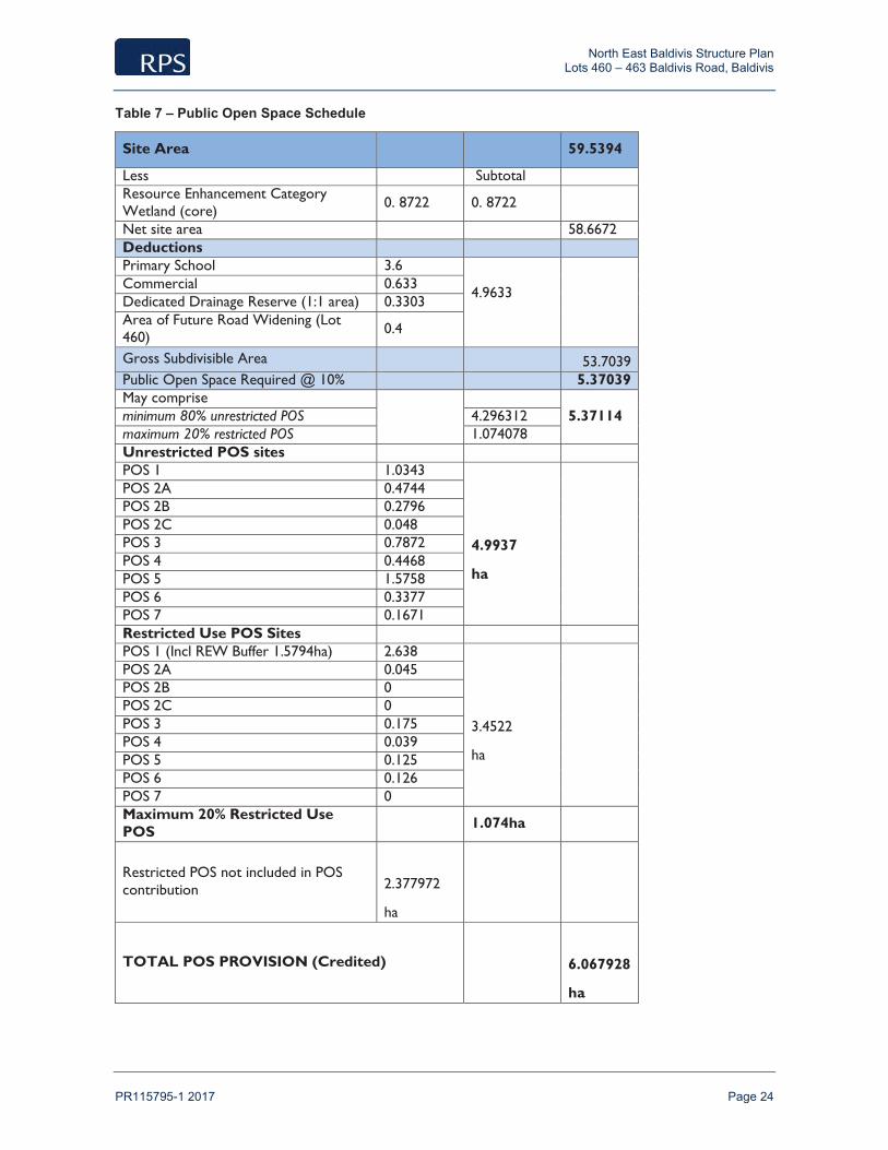
The NEBSP provides for a total of 8.44 hectares of POS (to be ceded as public open space) across the NEBSP area.
In accordance with the Element 4 (Public Parkland) requirements of Liveable Neighbourhoods, the POS Schedule for the SP is provided in Table 7 as follows.
North East Baldivis Structure Plan Lots 460 – 463 Baldivis Road, Baldivis
PR115795-1 2017 Page 24
Table 7 – Public Open Space Schedule
Site Area 59.5394
Less Subtotal Resource Enhancement Category Wetland (core) 0. 8722 0. 8722
Net site area 58.6672 Deductions Primary School 3.6
4.9633
Commercial 0.633 Dedicated Drainage Reserve (1:1 area) 0.3303 Area of Future Road Widening (Lot 460) 0.4
Gross Subdivisible Area 53.7039 Public Open Space Required @ 10% 5.37039 May comprise
5.37114
minimum 80% unrestricted POS 4.296312 maximum 20% restricted POS 1.074078 Unrestricted POS sites POS 1 1.0343
4.9937
ha
POS 2A 0.4744 POS 2B 0.2796 POS 2C 0.048 POS 3 0.7872 POS 4 0.4468 POS 5 1.5758 POS 6 0.3377 POS 7 0.1671 Restricted Use POS Sites POS 1 (Incl REW Buffer 1.5794ha) 2.638
3.4522
ha
POS 2A 0.045 POS 2B 0 POS 2C 0 POS 3 0.175 POS 4 0.039 POS 5 0.125 POS 6 0.126 POS 7 0 Maximum 20% Restricted Use POS 1.074ha
Restricted POS not included in POS contribution
2.377972
ha
TOTAL POS PROVISION (Credited)
6.067928
ha

North East Baldivis Structure Plan Lots 460 – 463 Baldivis Road, Baldivis
PR115795-1 2017 Page 25
The ultimate function and usability of the POS for active and passive recreational purposes (including local water management functions) will be subject to further detailed design at the subdivision stage to the satisfaction of the local authority.
The following table provides a full breakdown of each POS area.
Table 8 – Public Open Space Area Statistics
POS area Gross Area
(Ha)
Total Area of 1:1 Year
Drainage (Ha)
Total Area (Ha) of Restricted
POS (1:5 Drainage Area)
Creditable Restricted
Buffer
Total Area (Ha)
of Restricted POS
Net Unrestricted
POS Area (Ha)
1 3.769 0.0967 1.04 1.598 2.638 1.0343
2A 0.542 0.0226 0.045 0.045 0.4744
2B 0.2796 0 0 0 0.2796
2C 0.048 0 0 0 0.048
3 1.051 0.0888 0.175 0.175 0.7872
4 0.5184 0.0326 0.039 0.039 0.4468
5 1.745 0.0442 0.125 0.125 1.5758
6 0.5091 0.0454 0.126 0.126 0.3377
7 0.1671 0 0 0 0.1671
Total 8.6292 0.3303 1.55 3.148 5.1509
Further discussion regarding the use and treatment of POS areas is provided as follows.
3.2.1 Landscaping
A Landscape Masterplan has specifically been prepared to support the NEBSP (refer Figure 6). In addition to the Landscape Masterplan, concept plans have been prepared for each specific POS area identified in Table 8 together with key cross sections. These plans and cross sections are provided in Figure 7.
3.2.2 Baldivis Tramway Reserve
With respect to the adjoining Baldivis Tramway Reserve which runs parallel to Baldivis Road along the western boundary of the subject site, the landscape masterplan contemplates the provision of a landscaped entry statement.
These works will be subject to the approval of the City of Rockingham at the subdivision stage, which will provide the opportunity for the City to consider a detailed planting schedule submitted by the developer.
The EAR notes that vegetation within the Tramway Reserve consists of patches of Eucalyptus rudis with the occasional Melaleuca rhaphiophylla and Corymbia calophylla. The EAR also notes that there are groups of trees particularly in the southern end of the Tramway Reserve in “Good” condition, albeit that the Tramway is largely dominated by large open areas supporting weed growth.

North East Baldivis Structure Plan Lots 460 – 463 Baldivis Road, Baldivis
PR115795-1 2017 Page 26
With respect to the interface between the subject site and the Baldivis Tramway Reserve, the tramway reserve masterplan provides a number of indicative cross sections for which development interfacing should have due regard to. Figure 4.2.3 – Indicative Section C is particularly instructive, and represents the anticipated interface treatment that would be implemented for the majority of the subject site where a road interface is contemplated along the western boundary. Opportunities for a terraced interface between the boundary of lots and the tramway reserve may also be possible (Figure 4.2.1). The interface treatments between the subject site and tramway reserve will be considered in further detail at the detailed design/subdivision stage when final development levels are confirmed through the engineering design and Urban Water Management Plan.
3.2.3 Resource Enhancement Wetland
The RE wetland buffer and the encircling POS area will accommodate the following uses:
re-vegetation
bio-retention swales
walking/cycle paths
recreational spaces
Interface treatments proposed for protection of the RE wetland will be detailed in a Wetland Management Plan and a more detailed landscape plan to be submitted at the subdivision stage.
3.2.4 Other Public Open Space Areas
The NEBSP contains several parklands which are provided in a site responsive manner to maximise the retention of existing trees where practicable, and take into account other site characteristics such as topography and equitable distribution based on the layout of key road linkages and street blocks.
These parkland areas contain a mix of passive and semi-active (‘kickabout’) recreational areas. The POS areas have been specifically designed to be co-located with bio-retention areas in the form of multiple use corridors, whilst maintaining sufficient ‘dry’ recreational areas outside of bio-retention basins, which will be available for year round use. The co-located bio-retention areas have been designed having regard to Better Urban Water Management principles, and are expected to be useable for the majority of times during the year with the exception of periods of heavy rainfall inundation.
Careful consideration has been given to the retention of existing significant trees within the linear POS areas, and to the interface between POS areas and abutting residential lots as illustrated in the accompanying landscaping cross sections.
3.3 Residential
3.3.1 Dwelling Type and Distribution
The NEBSP contemplates a mix of medium density housing ranging from Residential R25 to R40, with a base density code of R25. This is intended to facilitate the delivery of a wide range of housing types, which will provide for the diverse and changing needs of the community.
The NEBSP establishes higher densities adjacent to proposed areas of POS, which will offer high amenity outlooks for future dwellings and provide increased passive surveillance for the POS area and adjacent streets. The range in residential densities provided by the NEBSP facilitates a variety of housing styles

North East Baldivis Structure Plan Lots 460 – 463 Baldivis Road, Baldivis
PR115795-1 2017 Page 27
being provided across the NEBSP area. Single residential lots/dwellings, grouped housing, multiple dwellings and ancillary dwellings are all permissible within the ‘Residential’ zone under TPS 2.
3.3.2 Dwelling Yield and Density Estimates
As illustrated in the table below, areas identified for ‘Residential’ purposes in the NEBSP are estimated to yield approximately 830 dwellings. An indicative lot layout plan which illustrates the potential dwelling yield is provided in Figure 8. Based on these dwelling yield estimates, the NEBSP achieves an estimated residential density of approximately 15 dwellings per gross hectare of ‘Urban’ zoned land, and 25 dwellings per net hectare of residential developable land. This is calculated as follows:
Table 9 – Residential Density Calculations
Indicator Amount
Gross SP area (all ‘Urban’ zoned land) 59.11 hectares
Net SP area identified for ‘Residential’ purposes 32.89 hectares
Total estimated dwellings 830
Estimated Gross Residential Density (Dwellings / Gross SP area) 15
Estimated Net Residential Density (Dwellings / Net Residential area) 25
These estimated residential densities meet the various density targets set by the following regional and district level planning documents:
Directions 2031 – Sets a target of 15 dwellings per gross urban zoned hectare in new development areas.
Liveable Neighbourhoods (Element 1, R17) – Recommends a minimum residential density of 20 to 30 dwellings per site hectare (net residential density) for areas within 400m of neighbourhood centres.
3.4 Movement Networks
A Transport Assessment (TA) has been specifically prepared to support the NEBSP. The TA and an associated addendum memorandum have been prepared by Cardno, and are provided in Appendix 4.
The TA has been prepared in accordance with the Western Australian Planning Commission (WAPC) Transport Assessment Guidelines for Developments: Volume 2 – Structure Plans (2006).
Site access arrangements including the proposed internal road network, intersections to Baldivis Road, access to the primary school site, access to the commercially zoned site, and the adequacy of the internal road hierarchy have been assessed by the TA. This assessment has been undertaken having regard to existing weekday traffic volumes occurring on surrounding roads being Baldivis Road, Mundijong Road and Kulija Road as identified in Table 2-1 of TA.
Traffic flow forecasts based on the proposed road network of the structure plan area are provided in Section 6.1 of the TA.
North East Baldivis Structure Plan Lots 460 – 463 Baldivis Road, Baldivis
PR115795-1 2017 Page 28
The TA assesses and validates stopping and intersection sight distances contemplated in the NEBSP, and how this relates to intersection spacing along Baldivis Road. Egress capacity has also been considered regarding the ability of vehicles to exit from an access into a traffic stream.
The TA identifies that additional widening along Baldivis Road will be required at intersection locations to provide for turning pockets and passing.
Intersection layout and spacing proposed along Baldivis Road is considered sufficient both in terms of safe distances and egress capacity for vehicle movements, and will operate within acceptable capacity limits with the proposed development traffic.
The proposed internal road hierarchy is illustrated in Figure 5-2 of the TA. This diagram is supported by typical cross sectional details for road reserves based on their hierarchy classification. These cross sectional details are in line with the Commission’s Liveable Neighbourhoods Policy.
It should be noted that road reserve widths associated with the road hierarchy classification are indicative only and would be discussed and agreed upon at the detailed design (subdivision) stage.
The outcomes of the TA indicate that the proposed development will not significantly impact the adjoining road network, will consist of a safe and effective internal road system, and has adequate access to regional cycling facilities. In this regard, an indicative path network plan illustrating the proposed future internal path network is provided in Figure 9.
Cardno undertook a further traffic analysis using new information in May 2017 for the intersection of Baldivis Road /Mundijong Road/Kulija Road and concluded that:
The existing intersection currently operates at an acceptable level of service
The existing intersection with the proposed development also operates at an acceptable level of service
The intersection is expected to require upgrading within 17 years to cater for future growth of the area. (assuming full buildout of the proposed North Baldivis Structure Plan and a linear 2% growth rate).
3.5 Water Management
A Local Water Management Strategy (LWMS) has specifically been prepared to support the NEBSP. The LWMS has been prepared by RPS, and is provided in Appendix 5.
The LWMS details the integrated water management strategies to facilitate future urban water management planning. The LWMS will achieve integrated water management through the following design objectives:
Effectively manage the risk to property damage and environmental degradation from water contamination, flooding and water logging;
Maintain water quality (surface and groundwater) within the development in relation to pre-development water quality;
Reduce potable water consumption within both public and private spaces through the use of practical and cost-effective measures;
Promote infiltration of surface water to minimise the risk of further water quality degradation in the Peel Harvey Catchment;
Implement best management practices in regards to stormwater management; and

North East Baldivis Structure Plan Lots 460 – 463 Baldivis Road, Baldivis
PR115795-1 2017 Page 29
Incorporate where possible, low maintenance, cost-effective landscaping and stormwater treatment systems.
The LWMS provides that the drainage objectives for stormwater management will involve the following elements:
Rainfall from 1 year 1 hr ARI (Annual Recurrence Interval) events (or 15 mm rainfall depth) will be retained and infiltrated as close to source as possible using soakwells, lot connection pits and biofiltration areas in each POS;
Flood storage will primarily be provided within bioretention areas and conveyance swales that convey drainage to the Peel Main Drain;
Stormwater entering each bioretention area will infiltrate into an underlying subsurface system that will discharge into a series of conveyance swales for additional treatment prior to off-site discharge;
POS 1 located adjacent to the REW will provide biofiltration areas directly adjacent to the REW, with overtopping to the REW occurring in larger events (> 1year 1 hour ARI). This will ensure pre-development surface water flows to the REW are maintained whilst improving water quality to the wetland;
Larger events (> 1year 1 hour ARI) will be detained in POS 2 to POS 7 and conveyed off site through a series of pipes and/or conveyance swales;
Drainage from the northern catchment will be treated within a vegetated median swale system in Pug Road that includes underground piped storage, prior to any downstream outflow; and
Outflow from the site will occur via four existing culverts, beneath the Kwinana Freeway to the east of the site, which ultimately deliver water to the PMD.
The same surface water management principles discussed above will be utilised in POS 1 directly adjacent to the REW, however the REW itself will be utilised to manage larger events in this location. This methodology is required in order to maintain the pre-development hydrological regime whilst improving water quality in this location generally.
In terms of water quality treatment, appropriate vegetation will be included in all biofiltration basins and substantial portions of the conveyance swales to help prevent erosion, maintain soil infiltration, restrict water flows and remove particulate and soluble pollutants, particularly nitrogen. Planting will occur within the bioretention areas of the basins over an area equivalent to at least 2% of the impervious road area.
The LWMS also identifies measures to control groundwater rise throughout the site whilst preventing any impacts on any ecological sensitive areas on site or nearby, including the REW at the south of the site and the PMD.
3.6 Education Facilities
As identified in the East Baldivis DSP, the provision of a primary school site is required to service the northern portion of the DSP cell bounded by Millar Road, Kwinana Freeway, Mundijong Road, and Baldivis Road. The DSP contemplates the land requirement for the primary school site being shared on a 50/50 basis with Lot 459 to the north of the subject site.
The NEBSP makes provision for a 3.5 hectare primary school site co-located with local open space in accordance with the Department of Education’s Primary School Site Planning Criteria completely within the structure plan area.

North East Baldivis Structure Plan Lots 460 – 463 Baldivis Road, Baldivis
PR115795-1 2017 Page 30
Consultation has been undertaken with the Department of Education with respect to the location of the primary school site relative to the proposed internal road network, and the proposed size and configuration of the school site relative to the structure plan area.
It is noted that the proposed location of the primary school site differs from the location contemplated in the East Baldivis DSP insofar as the proposed school site is situated within a more centralised portion of the NEBSP area relative to the surrounding catchment as opposed to the western portion.
The following justifications are provided with respect to the proposed location of the primary school site:
The site is better situated relative to the surrounding catchment and remains more centralised to its catchment having regard to the proposed road network;
Regular configuration of the site has been maintained;
Road access to the school site is optimised with regard to the Department of Education site planning criteria;
The location allows for higher amenity lots to be created in closer proximity to the tramway reserve taking advantage of the amenity values offered by the tramway;
The proposal enables the status quo to be maintained for Pug Road in terms of continuity of access from Pug Road through to Baldivis Road, negating the need to undertake any road closure of Pug Road at its interface with Baldivis Road;
More equitable distribution of POS within the adjoining structure plan areas is achieved through the school site oval being situated centrally relative to the future structure plan to be prepared to the north of the subject site;
There is no substantive benefit having school site POS abutting tramway and it reduces surveillance opportunities that could be achieved by having development adjoining/overlooking tramway;
Having the tramway abutting the development will increase opportunities for residents to use and care for tramway; and
A larger oval can be provided with the site being situated more centrally within the structure plan area as opposed to adjacent to the tramway.
The proposed location of the primary school site is supported by the Department of Education noting that all features of the site are consistent with the Department of Education’s site planning criteria.
3.7 Activity Centres and Employment
An Economic and Employment Assessment (EEA) has specifically been undertaken to support the NEBSP. The EEA has been prepared by Martinus Consulting, and is provided in Appendix 6.

North East Baldivis Structure Plan Lots 460 – 463 Baldivis Road, Baldivis
PR115795-1 2017 Page 31
Indicative Concept Plan – Commercial Zone
The NEBSP proposes the 0.6572 hectare portion of Lot 460 being assigned with a Commercial zone. The location of the proposed local centre is considered ideal as it will not only be serviced by the ultimate catchment of the resident population in the greater East Baldivis locality, but will also potentially capture significant passing trade using Baldivis Road. On this basis, the total catchment of this centre is considered capable of capturing sufficient patronage to sustain a local/mixed used centre with floor space of up to 1500sqm NLA.
Such business that may be attracted to the site might include services such as accountancy, barristers and solicitors, training specialists, people services/business coaching, personal training and/or health and wellness coaches, independent book publishing – eBooks and website development, property development consultants and the like.
North Baldivis is strategically located for residents and businesses to take advantage of a number of regional infrastructure opportunities including the Baldivis Library and Community Centre, Baldivis District Sporting Complex (expected completion 2017-2018), and the Baldivis Town Centre.
These significant regional infrastructure features will attract households of the mindset that they can contribute to, and make a living from, the economic activity of the area. Investment in provisioning infrastructure as residential and commercial lots are readied for market will promote the viability of the neighbourhood centre and the ‘liveability’ of North Baldivis.
A significant amount of work has been detailed in the most recent City of Rockingham Economic Development Strategy that makes mention of recent major development approvals that impact the Baldivis Activity Centre and the secondary economic consequences.

North East Baldivis Structure Plan Lots 460 – 463 Baldivis Road, Baldivis
PR115795-1 2017 Page 32
The major additions and alterations to the Baldivis Shopping Centre will mean that proximity to this centre will enhance the viability of micro and small business activity in North Baldivis.
Notwithstanding that development of the structure plan area will predominantly be for residential purposes, it will contribute to regional Rockingham in a number of ways, including:
Creation of over 700 direct and indirect jobs within the infrastructure provisioning, construction and operational stages;
Use of strategic location and road network to provide trip-linking possibilities which will greatly enhance commercial and business opportunities; and
Integrate directly into the aspirational statement of local job creation and self sufficiency in the City of Rockingham Economic Development Strategy 2014-2017.
Ultimately, the EEA recognises that by creating opportunities for local enterprises to occur, the provision of essential infrastructure that will be required to service the NEBSP area can be optimised. Additionally, the creation of lasting and diverse employment and investment opportunities within a defined area is consistent with the City’s Economic Development Strategy, and more broadly is consistent with the employment and sustainability objectives identified in Directions 2031.
North East Baldivis Structure Plan Lots 460 – 463 Baldivis Road, Baldivis
PR115795-1 2017 Page 33
3.8 Infrastructure Coordination, Servicing and Staging
3.8.1 Infrastructure Coordination and Servicing
An Engineering Infrastructure Report (EIR) has specifically been prepared to support the NEBSP. The EIR has been prepared by TABEC, and is provided in Appendix 7.
This EIR provides a broad range of advice with respect to servicing and infrastructure as it relates to the NEBSP area.
This EIR has been based on the civil engineering aspects of residential related land uses and summarises the availability of existing infrastructure assets in proximity to the landholding and the potential engineering infrastructure requirements to support urban development within the subject site.
The information provided in the EIR is preliminary and subject to change as the development process proceeds and more information and detail becomes available from the various service authorities.
3.8.1.1 Earthworks
Based on detailed geotechnical investigations, the subject site will require filling of between 0.7 metres to 1.7 metres of sand fill to achieve adequate separation distance from the 1 in 100 year flood level, with Class A sites being achievable across the majority of the NEBSP area. An indicative lot levels plan which illustrates the future finished lot levels is provided in Figure 10.
3.8.1.2 Surrounding Road Network
Access to the NEBSP area is available from Baldivis Road to the immediate west which is a local road vested in the City of Rockingham.
The NEBSP plan proposes a single intersection to be constructed onto Baldivis Road across the Tramway reserve. Access from Pug Road, which is an existing unmade road to the north, will also be available. Direct access from Mundijong Road to the south is not possible.
Mundijong Road has recently been upgraded and extended through to Mandurah Road. An un-signalised staggered T-intersection at Baldivis Road has been constructed with Mundijong Road as the priority route. Levels at the intersection have been raised from the natural surface by approximately 6 metres. Baldivis Road therefore ramps up to the intersection over a length of approximately 300+ metres. The alignment of Baldivis Road (north) now varies and occupies part of the Tramway reserve to suit the staggered T-intersection design.
Baldivis Road in its current state is a two lane undivided rural road with an 80km/hr speed limit. Intersections onto Baldivis Road will need to cater for the ultimate Baldivis Road configuration, which contemplates the widening of Baldivis Road and the construction of a 5 metre pavement width in each direction.
3.8.1.3 Stormwater Drainage
The EIR describes the location of the subject site relative to the Peel-Harvey catchment, noting that surface stormwater collected on site grades toward the Peel Main Drain (PMD) and drains through existing irrigation channels in an easterly direction through 4 adjacent culverts.
A constraint for the stormwater disposal is the low lying nature of the site with a high groundwater table and that a significant portion of the site contains clayey material. Consequently, infiltration on site has required

North East Baldivis Structure Plan Lots 460 – 463 Baldivis Road, Baldivis
PR115795-1 2017 Page 34
detailed consideration. Discharge of stormwater water through the Freeway culverts is possible, however the flow rate is restricted to a maximum permissible outflow of 4.5L/s/ha.
The EIR notes that the design of drainage facilities will consider the site conditions including the capacity for stormwater infiltration and conveyance of stormwater runoff via the road network to a conventional pit and pipe drainage network, with discharge into public open space areas where drainage basins and facilities will be located. The EIR also notes that the Baldivis Tramway Reserve will not be impacted by stormwater drainage runoff, and an outlet will be provided to ensure no ponding occurs within the tramway reserve. Additionally, a free outfall will be maintained with subsoil drainage outlets with these outlets being maintained 300mm above the culverts within the adjoining freeway reserve.
Drainage management measures have been identified through the Local Water Management Strategy prepared by RPS, which is provided in Appendix 5 and described in further detail in both the EIR and the LWMS.
3.8.1.4 Wastewater
It is noted that the Water Corporation has no permanent waste water outlet available to the subject site as the site falls into the catchment of the East Rockingham Waste Water Treatment Plant (ERWWTP) which is yet to become operational. To allow development to proceed, various interim solutions have been investigated and are described in further detail in the EIR.
Temporary discharge of waste water has been agreed to by the Water Corporation, subject to necessary upgrades at the existing receiving waste water pump station (WWPS). A plan illustrating the indicative location of the WWPS is provided in Figure 11.
Landholdings between Mundijong Road and Millar Road will ultimately be served via a Type 40 waste water pump station located in Lot 460 which is central to the catchment, necessitating the construction of pressure mains.
The EIR describes temporary conveyance solutions in the context of Water Corporation’s planning and funding priorities, and notes the ultimate wastewater flows will be directed toward the ERWWTP.
It will be necessary for the WWPS to be constructed in the first stage of development, with a deep gravity sewer main being directed to the WWPS location. The exact WWPS location remains to be determined. However, as planning progresses, the nominated WWPS site will form part of the subdivision plan, subject to Water Corporation acceptance.
The development will be served via a gravity fed network of varying sized sewer pipes designed in accordance with the Water Corporation specifications.
In summary, a viable solution for the interim and ultimate wastewater servicing of the NEBSP area exists, and is acceptable to the Water Corporation.
3.8.1.5 Water Supply
In response to updated Planning Framework in the South Metropolitan Peel sub-region, Water Corporation is currently in the process of revising and updating the water servicing planning for the area that appropriately addresses intended development. The previous strategy has been revised due to planning updates to the east of the Kwinana Freeway.
The Water Corporation is currently reviewing both long term strategies and short term solutions to enable the first stages of development to proceed at North Baldivis. TABEC and Cedar Woods Properties have been in

North East Baldivis Structure Plan Lots 460 – 463 Baldivis Road, Baldivis
PR115795-1 2017 Page 35
regular contact with the Water Corporation over the last 6 months to ensure this is tailored to the development time frame and rate of residential lot production.
An interim water servicing measure is likely to require a water distribution main being constructed from Fifty Road to Pug Road, and smaller reticulation water mains only being constructed to the north of Pug Road. a A thorough review of this infrastructure has been required due to the NEBSP area being situated across two reticulation scheme boundaries. This will also ensure the North Baldivis planning advice will adequately address other developments on Baldivis Road which are intended to commence in 2016. It is anticipated that an agreement for contributions from other developers will be sought for the practical implementation of water mains to suit Water Corporation’s requirements.
3.8.1.6 Power Supply
Existing Western Power overhead lines abut the subject site along Baldivis Road.
The EIR describes the location of nearby zone substations, and anticipates that no high voltage reinforcements will be required to supply the initial stages of the NEBSP.
Further upgrades of the network will be required when the existing network reaches capacity. The requirement and timing of these upgrades is dependent on the load growth of the subject site and surrounding developments.
Works within the subject site to service the ultimate load demand will include transformers and associated infrastructure as required by the staging of the development. There may also be a requirement to relocate existing overhead aerial transmission lines underground on the boundary of the subject site.
In summary, electrical supply will be available to service the NEBSP.
3.8.1.7 Telecommunications
NBN Co is responsible for the installation of optic fibre in all broad acre developments of 100 or more dwellings, within the long term optic fibre footprint, to which the NEBSP area will qualify. The developer will be responsible for providing pit and pipe infrastructure throughout the future subdivision for the optic fibre to be installed. Ultimately, there are no impediments to the supply of telecommunication infrastructure to service the subject site.
3.8.1.8 Gas Supply
An existing high pressure gas main is situated approximately 1.9km to the south of the proposed southern entry road to the NEBSP area.
ATCO Gas has confirmed the headworks required to provide services to the future subdivision which is illustrated in the EIR. The extension of the existing gas main will require significant construction costs. It has been confirmed that ATCO Gas would contribute the vast majority of this cost for these headworks, although a contribution would be sought from the developer to provide the infrastructure from which internal reticulation will be laid.
An internal gas supply will be provided to each lot through common trenching at no additional cost to the project.

North East Baldivis Structure Plan Lots 460 – 463 Baldivis Road, Baldivis
PR115795-1 2017 Page 36
3.8.2 Staging
There is no formal infrastructure coordination or staging arrangements proposed in the NEBSP, owing to the limited number of properties affected, the consolidated nature of the land tenure as being wholly owned subsidiaries of Cedar Woods Properties Ltd, and relatively straightforward approach to the provision of infrastructure and POS. A development staging plan illustrating potential staging of subdivision within the structure plan is provided in Figure 12.
It is noted that the proposed WWPS, pressure main and water trunk services identified in Section 4.4 are being planned with, and will be funded entirely by the proponent.
3.9 Developer Contribution Arrangements
The NEBSP area is located within Development Area 40 (DA 40) as identified in Schedule 9 of TPS 2. No specific developer contributions are identified as being applicable to the DA 40 area, nor has the subject site been identified in Schedule 10 – Developer Contribution Areas in TPS 2. In this regard, the NEBSP, and more broadly, the East Baldivis DSP is a largely self contained “cell” with infrastructure and services being funded entirely by the developers without the need for an overarching developer contribution framework.
The NEBSP area also falls within the Development Contribution Scheme No. 2 – Community Infrastructure, and infrastructure contributions in this regard will apply at the subdivision stage.
3.10 Other Requirements
3.10.1 Local Development Plans
To further guide and control development within the NEBSP area, Local Development Plans (LDP) will be prepared in the following instances:
For residential lots provided with vehicular access via a rear laneway;
For residential lots abutting proposed Parks and Recreation reserves;
For lots deemed to be affected by a recognised Bush Fire Hazard;
For lots deemed to be affected by transportation noise; and
For the land zoned as Commercial in the structure plan map.
LDPs may be prepared as part of a subdivision application or imposed as a condition of subdivision approval.
Matters to be addressed by LDPs for residential lots generally include:
Built form outcomes, including setbacks, garage locations and open space provision;
POS and private lot/dwelling interface, ensuring adequate surveillance of POS;
Appropriate separation of public and private space;
Orientation and design of homes to address solar orientation principles; and
On-street and off-street parking provision.

North East Baldivis Structure Plan Lots 460 – 463 Baldivis Road, Baldivis
PR115795-1 2017 Page 37
4.0 Conclusion
The purpose of this Structure Plan is to facilitate the future subdivision and development of the subject site, and to provide a range of housing types and densities that will assist in diversifying the existing housing stock within the City of Rockingham.
This Structure Plan has been prepared in accordance with the design requirements outlined in Liveable Neighbourhoods, and responds to requirements outlined in the City of Rockingham TPS 2.
The design of the Structure Plan is based on best-practice urban design principles, including housing choice/diversity, climatic responsiveness, sustainable urban water management, conservation of environmental assets (e.g. RE wetland), and the provision of a safe and efficient movement network.
The Structure Plan provides for the efficient and orderly development of planned residential land, and provides an appropriate and attractive interface between planned urban developments to the north and south.

North East Baldivis Structure Plan Lots 460 – 463 Baldivis Road, Baldivis
PR115795-12017
FIGURES

10km
20km
30km
40km
50km
60km
70km
F L IN TF L IN T
F LY N NF LY N N
MO U N T C O O K EMO U N T C O O K E
S O L U SS O L U S
MU C H E AMU C H E A
JA R R A H DA L EJA R R A H DA L E
B U L L S B R O O KB U L L S B R O O K
A S H E N D O NA S H E N D O N
PIN JA RPIN JA R
B A N K S IA DA L EB A N K S IA DA L E
S E R P E N T IN ES E R P E N T IN E
IN K P E NIN K P E N
N O RT H B A N N IS T E RN O RT H B A N N IS T E R
N A MB E E L U PN A MB E E L U P
PIC K E R IN G B R O O KPIC K E R IN G B R O O K
B Y F O R DB Y F O R D
MO U N T H E L E N AMO U N T H E L E N A
C A N N IN G VA L EC A N N IN G VA L E
E L L E N B R O O KE L L E N B R O O K
PO RT K E N N E DYPO RT K E N N E DY
E G L I N T O NE G L IN T O N
DA W E S V IL L EDA W E S V IL L E
T W O R O C K ST W O R O C K S
MU N D IJO N GMU N D IJO N G
MO R L E YMO R L E Y
H O P E VA L L E YH O P E VA L L E Y
R O C K I N G H A MR O C K I N G H A M
JO O N DA L U PJO O N DA L U P
H IL L A RY SH IL L A RY S
W E L S H P O O LW E L S H P O O L
MID L A N DMID L A N D
F R E MA N T L EF R E MA N T L E
S C A R B O R O U G HS C A R B O R O U G H
Q U IN N S R O C K SQ U IN N S R O C K S
CAN
NIN
GR
IVER
H ELEN A R I VER
AVO NRIVER
SWAN R IVER
SE R PEN T IN E RIVER
DARK IN R IVER
WO O R O LO O BR O O K
BIG BRO
OK
BR
OC
KM
AN
RIVER
BERAKING
BRO O K
N O R T H DAN DA L UP R IV ER
M U R RAY RIVER
O 'N EIL L BRO O
K
SO UT HD A N D A LUP RIVER
DALE RIV ER
W UN GO N G B R O O K
CHIN GANNIN
GGULLY
AL BA
NY
HIG
HW
AY
TO
OD
Y
A YR O
AD
G R E A T E A S T E R N H I G H
WA
Y
WA
NN
ER
OO
RO
AD
B R O O K T ON H IG H W A Y
SO
UT
HW
E S T ER NH
IGH
WA
Y
R O EH I G
HW
AY
KW
INA
NA
FR
EE
WA
Y
T H O M A SR O A D
TO
NK
INH
I GH
WA Y
N E A V E SR O
A D
R E I D H I G H W A Y
MIT
CH
EL
LF
RE
EW
AY
DE
LP A
RK
RO
AD
J A R R A H D A L E R O A D
CA
N N I NG
RO
AD
A R M A D A L E R O A D
FRE
MA
NT
LE
RO
AD
G R E A T S O U T H E R N H IG H W A Y
OLD
CO
A S TR O
A D
C A N N IN G H IGH W
AY
ST
OC
K R
OA
D
S O U T H S T R E E T
CL
AC
KIN
ET
OO
DY
AY
RO
AD
ST
IRL I
NG
H
IGH W A Y
P A T E RSO
NR
O
A D
K A L A MU NDA RO A D
YA N C H E PYA N C H E P
A R MA DA L EA R MA DA L E
MA N D U R A HMA N D U R A H
PIN JA R R APIN JA R R A
P E RT HP E RT H
116°
0'0
"E
32°0'0" S
B A L D IV ISB A L D IV IS
W E L L A R DW E L L A R D
P U G R DP U G R D
BA
LD
IVIS
RD
BA
LD
IVIS
RD
KW
INA
NA
FW
Y
KW
INA
NA
FW
Y
MIL L A R R D W
MIL L A R R D W
B O D MA N P LB O D MA N P L
KK EE RR OO SS EE NN EE LL
MU N D I JO N G R DMU N D I JO N G R D
SAB
RIN
A R
D
SAB
RIN
A R
D
KKWW
II NNAA
NNAA
FFWW
YY
0 1,000500m
0 250 500
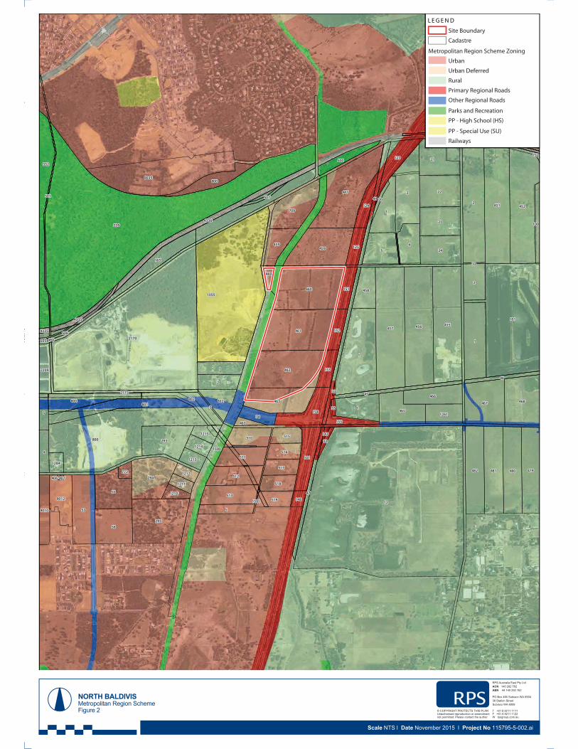
SU
HS
12
339
2170
1355
1
101
2
800
2
1
457 456 455
9035
451
447
452
461
460
462
295
3
1
53
1
4594
332
56
22
2
55
467 468
481482
21
480
23
24
294
463
479
709
2
293
801
1
465
5
800
165
513
154
466
512
1014
511
802
800
510
458
5
9012
123
459
802
341261
9010
519
518
517
124
151
152
516
153
500
515
125
2209
155
1214
1213
1215
1284
1211
1210
1212
148
772
463
460
1
45
4336
44
47
46
2173
100
512
512
501
1590
4335
20
32
507
3 33
506
143
4335
33
33
1591
505
407406
484
732
°
L E G E N D
Site Boundar y
C adastre
Metr opolitan R egion S chem e Z oning
Urban
Urban Deferred
Rural
Primar y Regional Roads
O ther Regional Roads
Parks and Recreation
PP - High School (HS)
PP - Special Uses (SU)
Railways
3Street, Subiaco
| T +
61 8 92111111 | F +61 8 92111122 |
ww
w.rpsgro
up.com
.au
NORTH BALDIVISMetropolitan Region SchemeFigure 2
RPS Australia East Pty LtdACN 140 292 762ABN 44 140 292 762
PO Box 465 Subiaco WA 690438 Station StreetSubiaco WA 6008
T +61 8 9211 1111F +61 8 9211 1122W rpsgroup.com.au
© COPYRIGHT PROTECTS THIS PLANUnauthorised reproduction or amendmentnot permitted. Please contact the author.
Site Boundary
Cadastre
Metropolitan Region Scheme Zoning
Urban
Urban Deferred
Rural
Primary Regional Roads
Other Regional Roads
Parks and Recreation
PP - High School (HS)
PP - Special Use (SU)
Railways
Scale NTS l Date November 2015 l Project No 115795-5-002.ai

NORTH BALDIVISEast Baldivis District Structure PlanFigure 3
RPS Australia East Pty LtdACN 140 292 762ABN 44 140 292 762
PO Box 465 Subiaco WA 690438 Station StreetSubiaco WA 6008
T +61 8 9211 1111F +61 8 9211 1122W rpsgroup.com.au
© COPYRIGHT PROTECTS THIS PLANUnauthorised reproduction or amendmentnot permitted. Please contact the author.
Scale NTS l Date November 2015 l Project No 115795-5-003.ai

2.5m Dual Use Path
Proposed Intersectionm
Sand Quarry 304m
Sand Quarry 405m
Clay Quarry 149m
NORTH BALDIVISOpportunities and ConstraintsFigure 4
RPS Australia East Pty LtdACN 140 292 762ABN 44 140 292 762
PO Box 465 Subiaco WA 690438 Station StreetSubiaco WA 6008
T +61 8 9211 1111F +61 8 9211 1122W rpsgroup.com.au
© COPYRIGHT PROTECTS THIS PLANUnauthorised reproduction or amendmentnot permitted. Please contact the author.
Scale NTS l Date November 2015 l Project No 115795-5-004.ai

BALD
IVIS
R
OAD
PUG ROAD
KWIN
ANA
FR
EEW
AY
MUNDIJONG
ROAD
510 515
Reserve 39885
P.O.S.
P.O.S.
P.O.S.P.O.S.
PS
P.O.S.
P.O.S.
P.O.S.
P.O.S.
463
461
462
459
460
460
458
1
463
459
NORTH BALDIVISStructure Plan - Aerial OverlayFigure 5
RPS Australia East Pty LtdACN 140 292 762ABN 44 140 292 762
T +61 8 9211 1111F +61 8 9211 1122W rpsgroup.com.au
© COPYRIGHT PROTECTS THIS PLANUnauthorised reproduction or amendmentnot permitted. Please contact the author.
Scale NTS l Date February 2017 l Project No 115795-5-005.dwg

NORTH BALDIVIS
LANDSCAPE MASTERPLAN
PREPARED FOR CEDAR WOODS
20 40 80 120 200 m0
JAN 2017REV gM1.101JOB NO. 1308502
1:2000 @ A1
LANDSCAPE ARCHITECTS 414 ROKEBY RD SUBIACO WA 6008 T: (08) 9388 9566 E: [email protected] LANDSPACE PTY LTD ACN 056 538 679COPYRIGHT This document is and shall remain the property of Plan E
POS 1
POS 2
POS 3
POS 5
PRIMARY SCHOOL SITE
POS 6
POS 4
POS 8
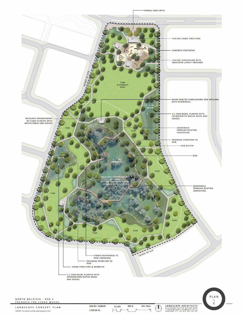
NORTH BALDIVIS POS 1
LANDSCAPE CONCEPT PLAN
PREPARED FOR CEDAR WOODS
5 10 20 30 50m00
DEC 2016REV BC1.101JOB NO. 1308505
1:500 @ A1
LANDSCAPE ARCHITECTSLANDSCAPE ARCHITECTS414 ROKEBY RD SUBIACO WA 6008T: (08) 9388 9566 E: [email protected] PTY LTD ACN 056 538 679COPYRIGHT This document is and shall remain the property of Plan E
EXTENT OF SITE
EXTENT OF SITE
FEATURE SHADE STRUCTURE
FORMAL PARK ENTRY
SHADE SHELTER OVERLOOKING REW WETLANDWITH BOARDWALK.
CONCRETE FOOTPATHS
FEATURE PLAYGROUND WITH INDICATIVE LAYOUT PROVIDED
SHADE STRUCTURE & BARBECUE
TIMBER BOARDWALK TO PATH CROSSINGS
REW BUFFER
RESOURCE ENHANCEMENT WETLAND
EXISTING VEGETATION TO BE RETAINED & PROTECTED
1 : 5 YR DRAINAGE
1 : 1 YR BASIN
1 : 1 YR BASIN
TURFKICKABOUT AREA
REW
RESOURCE ENHANCEMENT WETLAND PLANTED WITH NATIVE REEDS AND SEDGES
1:1 YEAR BASIN, PLANTED WITH APPROPRIATED NATIVE REEDS AND SEDGES
DRAINAGE OVERFLOW TO REW.
TURF
TURF
TURF
TURF
TURF
TURF
TURF
DRAINAGE OVERFLOW TO REW.
1:1 YEAR BASIN, PLANTED WITH APPROPRIATED NATIVE REEDS AND SEDGES
BOARDWALK THROUGH EXISTING VEGETATION.
BOARDWALK THROUGH EXISTING VEGETATION.

64
21
10m
0
DEC 2016
REV B
C2.102
JOB NO. 1308505
1:100 @ A1
T: (08) 9388 9566 E: [email protected]
COPYRIGHT This document is and shall remain the property of Plan E
LOT BOUNDARY
MATCHLINE AA
MATCH LINE AA
MATCHLINE BB
MATCHLINE BB
LOT BOUNDARY
1:1 YEAR LEVEL 5.80
1:100 YEAR LEVEL 4.621:10 YEAR LEVEL 4.531:10 YEAR LEVEL 4.39
1:1 YEAR BASE LEVEL 5.30
BASE LEVEL 4.30
BASE LEVEL 4.30
+5.95
REQUIREMENTS
CRACKED LATERITE AND BLUE

EXTENT OF SITE
TURF
TURF
TURF
EXTEEENTNTNTNTNTNTTTTTO
TOTNT OOTO
TOOOOOOOO
TO O
NT O
NTTNTTTTTOOTOOOOOOO
TOOO
TO
TNTTTTTTTTTOOOOTOOOOOO
T OOO
NNNTTTTTTNTOOOOOTOOOOOOOO
NNTTTTTTTOOO
NT OOOTOOOO
T O
NTTTTTTTTOOTOOO
TOOOOOOO
TO
TTTTTTOOOOOTO
TO
T O
NT O
NTTTT O
T O
TO
TOOOOOOT OO
TO
NNNTTTTTTTT TO
T OOOOO
NNTTTTT OOOT O
NTTTTTOO
NNNTTTOOOOOOT O
NNNNNNTTTTOOOOT O
NNNNNTTTT OOOOFSIFSFSIFSIFSFFSFSIF SIFSF SF SSSSFSFSF SIFSFSIFSISISIFSFSIFFSISISISFSF SISFSSSF SII
FSFSSIF SISIFFFFSF SISSIFSISSSFSSISIFFFFFSIFSF SIF SISSSSFSFFF SF SIFSSISS SI
FFFSFSIFFSSSI
F SIFSF SISI
FFSFSFSII
F SIFSI
FSSISFFFI
FFIITTTTETTETETETETETTTEETTTTEEETTETTTTTTTTETTTTTTTTTTTTTTTTTETTTTTTTTTTTTTTTTETTTETTTTTTE
TTTTUR
TTTUR
TUR
TUR
TURURR
TUR
TURRRRFFF
TUR
TUTUR
TURRRRRRR
TRRRRF
TTRR
TTTURRR
TTRRR
TTRRRR
TTRRRRF
TTRRR
TRFF
TRRF
TURRRRF
TUTUR
TUTUTUTUR
TTUR
TTUTURRRFRF
URF
TUTURUR
TURRR
TURURF
URF
URF
URF
URFRRRR
URURF
TUTURURRURURRRF
TUURRRRFRF
URRRURRFF
UUURRRRRF
TUUUUR
TUUUUUUUUUUUURUUUUUUUUTTT
UUR
TUR
TUURF
TUR
TUR
TURF
UURF
URF
URURF
URURF
URFRF
UURF
URF
URF
URF
URFRFF
TTTTUR
TURURF
URF
URURURFR
URF
URF
URF
URFRF
URF
URRF
TURUURRF
TRUR
TUURFFRRF
TTTTUUURFRFF
TTTTUUUUUURRRFFFFFFFFFFFF
TUFFFFFF
2.5
510
15
25m
0
JAN 2017
REV E
C1.101
JOB NO. 1308506
1:250 @ A1
T: (08) 9388 9566 E: [email protected]
COPYRIGHT This document is and shall remain the property of Plan E
SHADE STRUCTURE
1 : 1 YR BASIN
13M MIN OFFSET
TURF
TURF
TURF
TURF
1:100 YEAR BASIN,
B
C
B
C

64
21
10m
0
JAN 2017
REV B
C2.102
JOB NO. 1308506
1:100 @ A1
T: (08) 9388 9566 E: [email protected]
COPYRIGHT This document is and shall remain the property of Plan E
LOT BOUNDARY
LOT BOUNDARY
LOT BOUNDARYLOT BOUNDARY
+ RL 5.80
+ BASE LEVEL 5.25
+ BASE LEVEL 5.20
+ BASE LEVEL 5.25
+ 1:1 YEAR LEVEL 5.70
+ 1:100 YEAR LEVEL 5.60
+ 5.80
+ 1:100 YEAR LEVEL 5.60
REQUIREMENTS

5 10
20
30
50m
0
DEC 2016
REV C
C1.101
JOB NO. 1308507
1:500 @ A1
NORTH BALDIVIS POS 3
LANDSCAPE CONCEPT PLAN
PREPARED FOR CEDAR WOODS
LANDSCAPE ARCHITECTS
LANDSCAPE ARCHITECTS
414 ROKEBY RD SUBIACO WA 6008
T: (08) 9388 9566 E: [email protected]
LANDSPACE PTY LTD ACN 056 538 679
COPYRIGHT This document is and shall remain the property of Plan E
1:5 / 1:10 YR CONVEYANCE
SWALE
1:5 / 1:10 YR CONVEYANCE
SWALE 1 : 1 YR BASIN
1 : 1 YR BASIN
EXISTING VEGETATION TO
BE RETAINED & PROTECTED
WHERE POSSIBLE AND
APPROPRIATE. EXISTING
TREES TO BE ASSESSED BY
ARBORIST PRIOR TO FINAL
DETERMINATION.
TURF
TURF
1 : 100 YR DRAINAGE
OVERFLOW
1 : 100 YR DRAINAGE
OVERFLOW
TURF
SHADE STRUCTURE SEATING
NODE OVERLOOKING
TURF AND BASIN
FULLY IRRIGATED GARDEN BEDS
CONCRETE FOOTPATHS
BOARDWALK CROSSING
1:1 YEAR BASIN, PLANTED WITH
APPROPRIATE NATIVE REEDS AND
SEDGES
1:1 YEAR BASIN, PLANTED
WITH APPROPRIATE
NATIVE REEDS AND
SEDGES
TIMBER DECKS AND
BENCH SEATING

64
21
10m
0
DEC 2016
REV A
C2.102
JOB NO. 1308507
1:100 @ A1
T: (08) 9388 9566 E: [email protected]
COPYRIGHT This document is and shall remain the property of Plan E
LOT BOUNDARY
LOT BOUNDARYLOT BOUNDARY
LOT BOUNDARY
MATCHLINE AA
MATCH LINE AA
1:5 YEAR LEVEL 4.40
1:1 YEAR LEVEL 5.50
1:1 YEAR LEVEL 5.40
1:1 BASE LEVEL 4.90
1:100 YEAR LEVEL 5.101:10 YEAR LEVEL 4.93
1:5 YEAR LEVEL 4.40
BASE LEVEL 3.90
+ 5.50
1:10 YEAR LEVEL 4.93
1:100 YEAR LEVEL 5.10
BASE LEVEL 3.90
+5.50
+5.50
REQUIREMENTS
REQUIREMENTS
CRACKED LATERITE AND BLUE
CRACKED LATERITE AND BLUE
CRACKED LATERITE AND BLUE

2.5
510
15
25m
0
DEC 2016
REV C
C1.101
JOB NO. 1308508
1:250 @ A1
NORTH BALDIVIS POS 4
LANDSCAPE CONCEPT PLAN
PREPARED FOR CEDAR WOODS
LANDSCAPE ARCHITECTS
LANDSCAPE ARCHITECTS
414 ROKEBY RD SUBIACO WA 6008
T: (08) 9388 9566 E: [email protected]
LANDSPACE PTY LTD ACN 056 538 679
COPYRIGHT This document is and shall remain the property of Plan E
EXTENT OF SITE
1 : 100 YR DRAINAGE
OVERFLOW
TURF
1 : 1 YR
BASIN
RAISED SHADE STRUCTURE WITH BARBECUE
OVERLOOKING PLAYGROUND & TURF
ACCESS STAIRS AND WALLS TO SHADE STRUCTURE
PLAYGROUND WITH SOFTFALL SURROUNDS
FULLY IRRIGATED NATIVE GARDEN BED PLANTING
WITH 75mm MULCH & FEATURE GRASS TREES
FULLY IRRIGATED GARDEN BED
1:1 YEAR DRAINAGE BASIN
PLANTED WITH NATIVE REEDS,
SEDGES AND TREES
CONCRETE FOOTPATH
1:5/1:10 YEAR CONVEYANCE SWALE
BOARDWALK

64
21
10m
0
DEC 2016
REV A
C2.102
JOB NO. 1308508
1:100 @ A1
T: (08) 9388 9566 E: [email protected]
COPYRIGHT This document is and shall remain the property of Plan E
LOT BOUNDARY
LOT BOUNDARY
LOT BOUNDARY
LOT BOUNDARY
MATCH LINE AA
MATCH LINE AA
+6.30
+6.22
1:1 YEARLEVEL 6.22
1:100 YEAR LEVEL 6.12
1:100 YEAR LEVEL 6.12
1:100 YEAR LEVEL 6.12
1:10 YEAR LEVEL 5.89
1:10 YEAR LEVEL 5.89
1:10 YEAR LEVEL 5.89
+ 6.30
+ 5.89
+ 6.30
BASE LEVEL 5.30
BASE LEVEL 5.30
BASE LEVEL 5.30
REQUIREMENTS
CRACKED LATERITE AND BLUE
CRACKED LATERITE AND BLUE
CRACKED LATERITE AND BLUE

2.5
510
15
25m
0
DEC 2016
REV C
C1.101
JOB NO. 1308509
1:250 @ A1
NORTH BALDIVIS POS 5
LANDSCAPE CONCEPT PLAN
PREPARED FOR CEDAR WOODS
LANDSCAPE ARCHITECTS
LANDSCAPE ARCHITECTS
414 ROKEBY RD SUBIACO WA 6008
T: (08) 9388 9566 E: [email protected]
LANDSPACE PTY LTD ACN 056 538 679
COPYRIGHT This document is and shall remain the property of Plan E
EXTENT OF SITE
1 : 1 YR BASIN
1 : 1 YR BASIN
EXISTING VEGETATION TO BE RETAINED
& PROTECTED WHERE POSSIBLE AND
APPROPRIATE. EXISTING TREES TO BE
ASSESSED BY ARBORIST PRIOR TO FINAL
DETERMINATION
TURF
1:100 YR DRAINAGE
OVERFLOW
TURF
SHADE STRUCTURE WITH BBQ OVERLOOKING
TURF KICK-ABOUT & BASIN
1:5/1:10/1:100 CONVEYANCE SWALE
SIDESLOPES AT 1:4 GRADE
DRAINAGE BASIN PLANTED WITH NATIVE REEDS,
SEDGES AND TREES
FITNESS CIRCUIT WITH VARIOUS
OUTDOOR EQUIPMENT ON SOFTFALL

64
21
10m
0
DEC 2016
REV D
C2.102
JOB NO. 1308509
1:100 @ A1
T: (08) 9388 9566 E: [email protected]
COPYRIGHT This document is and shall remain the property of Plan E
LOT BOUNDARY
MATCHLINE AA
MATCH LINE AA
1:5 YEAR LEVEL 5.44
1:1 YEAR LEVEL 5.90
1:1 BASE LEVEL 5.40
1:100 YEAR LEVEL 5.90
1:100 YEAR LEVEL 5.90
BASE LEVEL 5.90
+5.90
REQUIREMENTS
CRACKED LATERITE AND BLUE

2.5
510
15
25m
0
DEC 2016
REV B
C1.101
JOB NO. 1308510
1:250 @ A1
NORTH BALDIVIS POS 6
LANDSCAPE CONCEPT PLAN
PREPARED FOR CEDAR WOODS
LANDSCAPE ARCHITECTS
LANDSCAPE ARCHITECTS
414 ROKEBY RD SUBIACO WA 6008
T: (08) 9388 9566 E: [email protected]
LANDSPACE PTY LTD ACN 056 538 679
COPYRIGHT This document is and shall remain the property of Plan E
EXTENT OF SITE
TURF
TURF
TURF
1 : 1 YR BASIN
1 : 1 YR BASIN
FULLY IRRIGATED GARDEN BED
CONVEYANCE SWALE PLANTED WITH
NATIVE REEDS, SEDGES &
TREES
CONCRETE FOOPATHS
1:5/1:10/1:100
CONVEYANCE SWALE

64
21
10m
0
JAN 2017
REV B
C2.102
JOB NO. 1308510
1:100 @ A1
T: (08) 9388 9566 E: [email protected]
COPYRIGHT This document is and shall remain the property of Plan E
LOT BOUNDARY
LOT BOUNDARY
1:100 YEAR LEVEL 5.16
1:1 YEAR LEVEL 5.20
1:1 YEAR BASE 4.70
1:10 YEAR LEVEL 4.91
1:5 YEAR LEVEL 4.56
BASE LEVEL 4.00
+5.40
+5.20
+5.20
+5.20
+5.40
REQUIREMENTS
CRACKED LATERITE AND BLUE
LOT BOUNDARY
LOT BOUNDARY
1:100 YEAR LEVEL 5.16
1:10 YEAR LEVEL 4.91
1:5 YEAR LEVEL 4.56
BASE LEVEL 4.00
+5.40
+5.20
+5.20
+5.40
CRACKED LATERITE AND BLUE

BALD
IVIS
R
OAD
PUG ROAD
KWIN
ANA
FR
EEW
AY
MUNDIJONG
ROAD
510 515
460
Reserve 39885
460
P.O.S.
P.O.S.
P.O.S.P.O.S.
PS
P.O.S.
P.O.S.
P.O.S.
P.O.S.
463
461
462
459
460
460
458
1
463
459
NORTH BALDIVISLot LayoutFigure 8
RPS Australia East Pty LtdACN 140 292 762ABN 44 140 292 762
T +61 8 9211 1111F +61 8 9211 1122W rpsgroup.com.au
© COPYRIGHT PROTECTS THIS PLANUnauthorised reproduction or amendmentnot permitted. Please contact the author.
Scale NTS l Date February 2017 l Project No 115795-5-011i.dwg

BALD
IVIS
R
OAD
PUG ROAD
KWIN
ANA
FR
EEW
AY
MUNDIJONG
ROAD
510 515
460
Reserve 39885
460460460
P.O.S.
P.O.S.
P.O.S.
P.O.S.
PS
P.O.S.
P.O.S.
P.O.S.
P.O.S.
463
461
462
459
460
460
458
1
463
459
NORTH BALDIVISMovement NetworkFigure 9
RPS Australia East Pty LtdACN 140 292 762ABN 44 140 292 762
T +61 8 9211 1111F +61 8 9211 1122W rpsgroup.com.au
© COPYRIGHT PROTECTS THIS PLANUnauthorised reproduction or amendmentnot permitted. Please contact the author.
Scale NTS l Date February 2017 l Project No 115795-5-011i.dwg
LegendSite Boundary
Public Open Space
Existing Vegetation
Path Network
2.5m Shared Path (D.U.P)
2m Footpath
Principal Shared Path
Bridle Path (Indicative only -
By others)
Landscape Path
Road Network
Neighbourhood Connector B
Access Street
200m Catchment - Bus Route

BALD
IVIS
R
OAD
PUG ROAD
KWIN
ANA
FR
EEW
AY
MUNDIJONG
ROAD
510 515
460
Reserve 39885
460
P.O.S.
P.O.S.
P.O.S.P.O.S.
PS
P.O.S.
P.O.S.
P.O.S.
P.O.S.
463
461
462
459
460
460
458
1
463
459
6.1
6.1
6.16.1
6.1
6.1
6.1
6.1
6.1
6.1
6.1
6.1
6.1
6.1
6.16.1
6.9
7.5
6.6
6.5 6.2
6.6
7.6
6.7
7.2
7.9
7.4
6.4
6.4
7.2
7.46.3
6.57.4
7.5
7.7 7.4
7.1
6.8
6.7
7.27.0
6.3
6.3 6.5
6.1
6.5
6.1
6.16.2
6.1
6.16.1
6.1
6.3
6.1
6.1
6.1
NORTH BALDIVISIndicative Lot Level PlanFigure 10
RPS Australia East Pty LtdACN 140 292 762ABN 44 140 292 762
T +61 8 9211 1111F +61 8 9211 1122W rpsgroup.com.au
© COPYRIGHT PROTECTS THIS PLANUnauthorised reproduction or amendmentnot permitted. Please contact the author.
Scale NTS l Date February 2017 l Project No 115795-5-011i.dwg

P.O.S.
FUTUREP.O.S.
KWIN
ANA
FREE
WAY
NORTH BALDIVISWaste Water Pump Station LocationFigure 11
RPS Australia East Pty LtdACN 140 292 762ABN 44 140 292 762
T +61 8 9211 1111F +61 8 9211 1122W rpsgroup.com.au
© COPYRIGHT PROTECTS THIS PLANUnauthorised reproduction or amendmentnot permitted. Please contact the author.
Scale NTS l Date February 2017 l Project No 115795-5-011i.dwg
LegendType 40 (WWPS)(Indicative Location)30m Buffer
FUTUREDEVELOPMENT
PUG ROAD
PRIMARYSCHOOL

BALD
IVIS
R
OAD
PUG ROAD
KWIN
ANA
FR
EEW
AY
MUNDIJONG
ROAD
510 515
460
Reserve 39885
460
P.O.S.
P.O.S.
P.O.S.P.O.S.
PS
P.O.S.
P.O.S.
P.O.S.
P.O.S.
463
461
462
459
460
460
458
1
463
459
1E 1TAGE 1 1E GATASTTS EGETAGEGEAGTATSTTSSTSST
E 2E 2E 2E 2AGEEAGAGTATATAAGEEEAGEAGSTASTSTSSS AGEE
3333AGEGEAGEAGESTASTAAGE AGEAGTATATASSSSSTAAGE
GE 4E 4GE 4GE 4444GGGAGTAGTAG 4GE 4GGGEGESTAGAGSTASTASTSTAG
STAGE 5A 5GSTAGE 5STAGS
STAGE 6AGETSTAGE 6STAT
STAGE 7E 7TASTAGE GETA
STAGE 8T G 8STAGE T G
OP OOPSTTAGE 99T P9E GEAGASTTAGET EGATA
TAGE 10AGE 10GGTSTAGE 1TAGGSST
TAGE 11AAGE 11G 1TSTAGE 1TASTAGG 1T
AGTTAAGE 12GTA 2AGTTTAAGE 1ST GSTTAAS
TAGE 13T 313E 1EGATSTAGE 1ST 1EGAGTASTS
NORTH BALDIVISDevelopment Staging PlanFigure 12
RPS Australia East Pty LtdACN 140 292 762ABN 44 140 292 762
T +61 8 9211 1111F +61 8 9211 1122W rpsgroup.com.au
© COPYRIGHT PROTECTS THIS PLANUnauthorised reproduction or amendmentnot permitted. Please contact the author.
Scale NTS l Date February 2017 l Project No 115795-5-011i.dwg
LegendSite BoundaryIndicative Stage Boundary


