46
Southeast Asia Participatory Poverty and Livelihood Assessment Report, Kalahan, Nueva Vizcaya, The Philippines Grace Villamor and Moises Pindog
Southeast Asia
Participatory Poverty and Livelihood Assessment
Report, Kalahan, Nueva Vizcaya, The Philippines
Grace Villamor and Moises Pindog
Participatory Poverty and Livelihood
Assessment Report, Kalahan, Nueva
Vizcaya, The Philippines
Grace Villamor and Moises Pindog
Working Paper nr 67
Correct citation: Villamor, G.B. and M. Pindog. 2008. Participatory poverty and livelihood assessment report, Kalahan, Nueva Vizcaya, the Philippines. WP number 67. Bogor, Indonesia, World Agroforestry Centre - ICRAF, SEA Regional Office. 37p. Titles in the Working Paper Series aim to disseminate interim results on agroforestry research and practices and stimulate feedback from the scientific community. Other publication series from the World Agroforestry Centre include: Agroforestry Perspectives, Technical Manuals and Occasional Papers. Published by World Agroforestry Centre Transforming Lives and Landscapes ICRAF Southeast Asia Regional Office Jl. CIFOR, Situ Gede, Sindang Barang, Bogor 16680 PO Box 161, Bogor 16001, Indonesia Tel: 62 251 625415, fax: 62 251 625416 Email: [email protected] ICRAF Southeast Asia website: http://www.worldagroforestrycentre.org/sea Working Paper nr 67 The views expressed in this publication are those of the author(s) and not necessarily those of the World Agroforestry Centre. Articles appearing in this publication may be quoted or reproduced without charge, provided the source is acknowledged. All images remain the sole property of their source and may not be used for any purpose without written permission of the source. Disclaimer for copyright page: This text is a ‘working paper’ reflecting research results obtained in the framework of ICRAF Southeast Asia project. Full responsibility for the contents remains with the authors.
Table of Content
Table of Content .............................................................................................................i List of Abbreviations .....................................................................................................ii List Of Figures ............................................................................................................. iii List Of Tables .............................................................................................................. iii Executive Summary ......................................................................................................iv1. Introduction.............................................................................................................1 2. Methodology ............................................................................................................4 3. Results and Discussion............................................................................................6
3.1 Biophysical Characteristics................................................................................6 3.2 Institutions and Infrastructure ............................................................................7 3.3 Socio-Economic Characteristics ......................................................................10 3.4 Who are the Poor in the Community?..............................................................15 3.5 People's Perception of Environmental Services and Its Potential
Impact on Poverty and Livelihood...................................................................23 3.6 Potential Constraints on Effective Utilization of Environmental
Services ............................................................................................................24 4. Conclusion ............................................................................................................25
References..............................................................................................................26 Appendices...................................................................................................................27
- i -
List of Abbreviations
ADB - Asian Development Bank
ARBs - Agrarian Reform Beneficiaries
BFAD - Bureau of Food and Drugs
CARP - Comprehensive Agrarian Reform Program
CBFMA - Community-Based Forest Management Agreement
DA - Department of Agriculture
DECS - Department of Education, Culture and Sports
DPWH - Department of Public Works and Highways
FGD - Focus Group Discussion
KEF - Kalahan Educational Foundation
LPG - Liquefied Petroleum Gas
MAO - Municipal Agricultural Office
MCLUP - Municipal Comprehensive Land Use Plan
MDGs - Millennium Development Goals
MOA - Memorandum of Agreement
NGO - Non-government organization
NIA - National Irrigation Authority
NUVELCO - Nueva Vizcaya Electric Cooperative, Inc.
PIN - Project Identification Note
RES - Rewarding Environmental Services
RUPES - Rewarding Upland Poor for Environmental Services
- ii -
List Of Figures
Figure 1. Map of the Kalahan Forest Reserve ....................................................................... 3
List Of Tables
Table 1. Unit of analysis (as agreed upon by the RUPES Team). ......................................... 4 Table 2. Land area per barangay, Sta. Fe, Nueva Vizcaya .................................................... 6 Table 3. Enrolment, teacher and classroom to pupil ratio elementary and primary, 2000. ... 7 Table 4. List of secondary level schools (high school), Sta. Fe, 2000................................... 8 Table 5. List of irrigation facilities, selected barangays, Sta. Fe, Nueva Vizcaya, 2000....... 8 Table 6. Road Description, 2000. .......................................................................................... 8 Table 7. Inventory of Energized Barangay, 2000. ................................................................. 9 Table 8. Number of population, households, and population density of selected barangays, Sta. Fe, Nueva Vizcaya, 2000.............................................................. 10 Table 9. Total and average household income, selected barangays, Sta. Fe, Nueva Vizcaya, 1995. ....................................................................................................... 11 Table 10. Total and average annual household expenditures, selected barangays, Sta. Fe, Nueva Vizcaya, 1990.............................................................................. 11 Table 11. Status of Comprehensive Agrarian Reform Program (CARP), Sta. Fe, Nueva Vizcaya, 2000. ..................................................................................................... 12 Table 12. Provisions for agricultural services and other post harvest facilities, Sta. Fe, 2000. ....................................................................................................... 12 Table 13. Physical area devoted to palay by production environment (in hectares), selected barangays, Sta. Fe, Nueva Vizcaya, 2000.............................................. 12 Table 14. Physical area devoted to fruits and vegetable production (in hectares), selected barangays, Sta. Fe, Nueva Vizcaya, 2000.............................................. 14 Table 15. Type of Commercial Establishment, number and area occupied in
Sta. Fe, 2000........................................................................................................ 15 Table 16. Proportion of household poor based on barangays in the study site. ................... 16 Table 17. Rank of identified poverty indicators in the study barangays.............................. 16
List Of Appendices
Appendix 1. Participatory Poverty Assessment Methodology for RUPES Sites ................. 27 Appendix 2. Natural resources development program and Agro-forestry rules and
regulations ....................................................................................................... 31 Appendix 3. Potential forest enterprises .............................................................................. 37
- iii -
Executive Summary
A participatory poverty assessment of the RUPES Kalahan Project was conducted to (1) establish the baseline for multi-dimensional indicators of poverty using participatory approach; and (2) identify and analyze constraints that hinder communities from effectively benefiting from rewards for environmental services (RES). This study closely followed the steps learned from the participatory poverty assessment training of the RUPES sites’ team members held on November 2007.
As a result, two overall observations where poverty dimensions co-vary with degradation (Van Noordwijk, et al., 2004) in Kalahan were made, these are (1) people living in remote forest environments rich in all aspects of environmental services, but poor because of lack of public services (health and education) and low income but with enough to eat; and (2) people who lived in landscapes where rehabilitation starts to be successful have the prospects of reducing all dimensions of poverty.
It was concluded that poverty in Kalahan is linked to the lack of access and/or underdeveloped public services such as market infrastructures, education and health services while the focus of rewards for environmental services is recommended in the provision of these public services. Once the reward is realized, special attention should be given to the communities from Barangay Unib, Malico and Sta. Rosa.
- iv -
Introduction The State of the Environment in Asia and the Pacific 2000 reports that poverty reduction is recognized as a critical element of sustainable development and is still the over-riding concern of most countries, and in particular of developing countries. In 2004, nearly 670 million people, 63 percent of the world’s poor were still living on less that US$1 a day in the region (ESCAP, 2005).
In the Philippines, as of 2000, 16.7 percent of total families (or 20.9 percent of the population) were core poor i.e. food poor or lived below subsistence (NEDA, 2003). About 70 percent of these families reside in the rural areas and make a living from rural-based crops such as rice, corn, coconut and tobacco. Balisacan, et al., (2002) mention the existence of ‘poverty traps’ such as lack of access to education and health services which limits the benefits of national income growth for the welfare of the poorest segments of the population (ESCAP, 2005).
At the same year, the world leaders adopted the United Nations Millennium Declaration to the pursuit of the Millennium Development Goals (MDGs). This global agenda of eight development goals envision of addressing extreme poverty and all its dimensions - cutting world poverty and hunger in half in 2015, improving health, promoting peace, human rights, gender equality and environmental sustainability.
While the Philippine government is continuously committed and consistent towards extreme poverty eradication and protecting the vulnerable groups by formulation and implementation of various policy reforms and strategies for the improvement of the quality of the life of Filipinos, they could not do it alone. Moreover, since poverty has many dimensions and gaps across sectors that must be addressed particularly in the rural areas, partners and initiatives among various organizations and agencies are needed.
The Kalahan Education Foundation (KEF), organized by the tribal elders of the Ikalahan People of Nueva Vizcaya and Pangasinan, together with the World Agroforestry Centre is implementing the Rewarding Upland Poor for Environmental Services (RUPES) Programme in their Ancestral Domain. The programme aims to enhance the livelihoods and reduce poverty of the upland poor while supporting environmental conservation on biodiversity protection, watershed management, and carbon sequestration.
RUPES Kalahan and KEF are developing markets for carbon sequestration; watershed protection and biodiversity to provide bundled value that can generate larger incentives for members of the community. These include preparation of “Forestry Project Idea Note (PIN) on a Carbon Sequestration Project in the Ancestral Domain of Ikalahan”; continuous measurement of carbon stocks in the production forest; discussions with the managers of Magat Dam, which Kalahan supplies water to; and establishment of bird watching activities in the wildlife sanctuaries.
To date, the programme has so far made records of tree growth over 12 years for 10,000 hectares of production forests, with all records blocked and mapped. The capacity of the people involved in the project on issues such as carbon sequestration, mapping and water measurement has developed. Trained foresters are now available. There is also a significant increase in awareness of the importance of sanctuaries to maintain biodiversity. For forming
- 1 -
effective partnerships and methods, three other people’s organizations have become newly registered and in the process of registering. Two networks have also been established: the Philippine Association for Intercultural Development and the Upland NGO Assistance Committee.
Objectives: Owing to the abovementioned efforts, a poverty assessment of the RUPES Kalahan Project was conducted to:
1.1 Establish the baseline for multi-dimensional indicators of poverty using participatory approach; and
1.2 Identify and analyze constraints that hinder communities from effectively benefiting from rewards for environmental services (RES).
Site Description The Ikalahan Ancestral Domain, which includes the Kalahan Forest Reserve, is located in the provinces of Nueva Vizcaya and Nueva Ecija. It covers 48,000 hectares of mountainous land with rainfall ranging from 3,000 to 5,000 mm per year. Much of the area is forested, mostly with dipterocarp species although the western edge is mostly pine. Some of the forests are primary, but most are secondary. Broad areas in the east are barren because of logging, which outsiders did several decades ago (KEF, 2003).
Most of the areas where the RUPES program is implemented belong to the municipality of Sta. Fe. It includes six barangays (villages) namely, Bacneng, Baracbac, Imugan, Unib, Malico and Sta. Rosa. The center of the municipality is Imugan, which is 6 km from Sta. Fe town proper.
The Kalahan Forest Reserve, a 14,730-hectares of forestland set aside by the MOA of 1974, covers the barangays of Imugan, Malico, Baracbac, Unib and Bacneng. The reserve contains three major types of forests – pine forest on the western portion; dipterocarp forests comprise the eastern part; and mossy forest on the central portion. Within the reserve, sanctuaries were set aside for watershed and wildlife protection. Small swidden farms of up to three hectares each are interspersed with the forest stands.
Biodiversity is high in the reserve. A KEF inventory of flora and fauna has identified already 1,553 species of plants and more than 150 species of birds. Ten species of plants and 35 species of birds are considered endangered species. Around 20 species of birds are in the process of identification as possible new records in the site.
The Ikalahans are the indigenous people inhabiting the area. Originally hunters and gatherers, the Ikalahans have been swidden farmers for at least two centuries, coaxing the thin, acidic soils of their land to produce their traditional food, sweet potatoes or camote (FPE, 2001).
- 2 -
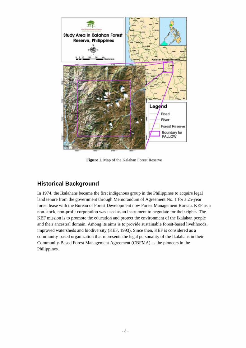
Figure 1. Map of the Kalahan Forest Reserve
Historical Background In 1974, the Ikalahans became the first indigenous group in the Philippines to acquire legal land tenure from the government through Memorandum of Agreement No. 1 for a 25-year forest lease with the Bureau of Forest Development now Forest Management Bureau. KEF as a non-stock, non-profit corporation was used as an instrument to negotiate for their rights. The KEF mission is to promote the education and protect the environment of the Ikalahan people and their ancestral domain. Among its aims is to provide sustainable forest-based livelihoods, improved watersheds and biodiversity (KEF, 1993). Since then, KEF is considered as a community-based organization that represents the legal personality of the Ikalahans in their Community-Based Forest Management Agreement (CBFMA) as the pioneers in the Philippines.
- 3 -
Methodology This study closely followed the steps learned from the participatory poverty assessment training of the RUPES sites’ team members held on November 2006.
Step 1: Compilation of all available secondary data related to poverty and livelihood in the study site and familiarization of the overall poverty scenario. These include the Municipal Comprehensive Land Use Plans, Barangay Profiles, and research studies conducted in the area.
Step 2: Grouping of 10-15 knowledgeable people for focus group discussions. The following points were considered while deciding the number and composition of focus groups (table 1).
- Groups should be as homogenous as possible.
- Groups should be representative of the entire target area of the RUPES Programme.
- Local leaders and NGOs consultation to identify key informative people that could represent a particular community. Researchers briefly interviewed the identified key people before deciding whether to include them in focus groups.
Table 1. Unit of analysis (as agreed upon by the RUPES Team).
RUPES Site Unit of Analysis Kalahan 6 Barangays, 1 municipality, 1
province, 1 cluster 2 FGDs:
(1) High elevation – Barangays Malico 1 & 2, and Sta. Rosa (15 participants)
(2) Low elevation – Barangays Imugan, Unib, Baracbac, and Bacneng (25 participants)
Step 3: Preparation of requirements for focus group discussion.
1. Lead moderator and two assistants.
2. Recorder, notebooks, etc.
3. Incentive arrangement for participants.
Step 4: Preparation for focus group discussion.
1. Inform participants time and date of focus group discussion on time.
2. Explain ground rules to participants (e.g. no one participant will be allowed to dominate discussion, that the conversation will be recorded but the names will be kept confidential in the report, etc).
3. Explain the objectives of focus group discussion to participants.
- 4 -
Step 5: Explanation of the objectives of FGD to groups as follows:
1. That the RUPES program aims to reward the community for environmental services they are providing and the reward has the potential to improve their livelihood.
2. The assessment of the present status of poverty and livelihood in the community will serve as a baseline (comparative study after a few years would be able to tell whether reward mechanism is having a positive impact on livelihood or not).
Step 6: Focus group discussion.
The focus group discussion covered the following five main topics (see Appendix 1 for details):
1. Establishing the proportion of poor households in the community through:
a. Identification of the proportion of households whom the respondents would consider poor in the community they represent
b. Listing of indicators the respondents use to identify poor households
c. Ranking of the identified indicators in order of importance in a scale of 1 to 5 (1 = least important, 5 = most important)
d. Averaging of threshold for the most important one or two indicators, and identifying how many households in the community fall below the threshold; and
e. Classifying the indicators identified by the group into one of the five capitals.
2. People's perception on the causes of poverty
3. Present status of people's poverty and livelihood situation
4. People's perception and understanding of environmental services and how they think it will impact their livelihood
5. Constraints of communities to effectively benefit from payments for environmental services
- 5 -
Results and Discussion
3.1 Biophysical Characteristics1
Land Area
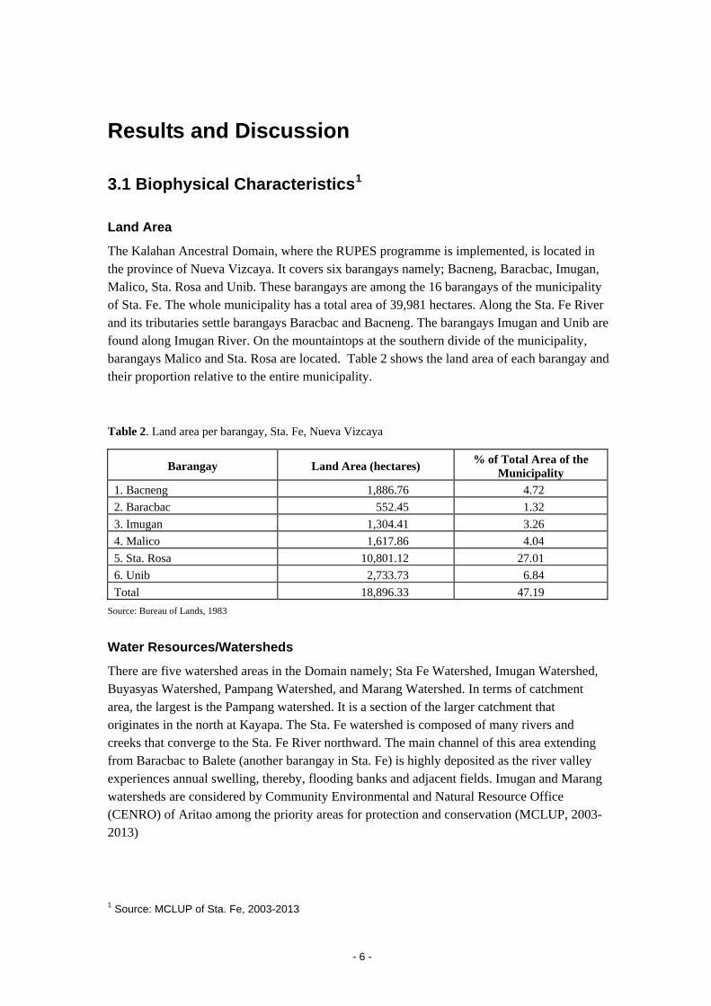
The Kalahan Ancestral Domain, where the RUPES programme is implemented, is located in the province of Nueva Vizcaya. It covers six barangays namely; Bacneng, Baracbac, Imugan, Malico, Sta. Rosa and Unib. These barangays are among the 16 barangays of the municipality of Sta. Fe. The whole municipality has a total area of 39,981 hectares. Along the Sta. Fe River and its tributaries settle barangays Baracbac and Bacneng. The barangays Imugan and Unib are found along Imugan River. On the mountaintops at the southern divide of the municipality, barangays Malico and Sta. Rosa are located. Table 2 shows the land area of each barangay and their proportion relative to the entire municipality.
Table 2. Land area per barangay, Sta. Fe, Nueva Vizcaya
Barangay Land Area (hectares) % of Total Area of the Municipality
1. Bacneng 1,886.76 4.72 2. Baracbac 552.45 1.32 3. Imugan 1,304.41 3.26 4. Malico 1,617.86 4.04 5. Sta. Rosa 10,801.12 27.01 6. Unib 2,733.73 6.84 Total 18,896.33 47.19
Source: Bureau of Lands, 1983
Water Resources/Watersheds
There are five watershed areas in the Domain namely; Sta Fe Watershed, Imugan Watershed, Buyasyas Watershed, Pampang Watershed, and Marang Watershed. In terms of catchment area, the largest is the Pampang watershed. It is a section of the larger catchment that originates in the north at Kayapa. The Sta. Fe watershed is composed of many rivers and creeks that converge to the Sta. Fe River northward. The main channel of this area extending from Baracbac to Balete (another barangay in Sta. Fe) is highly deposited as the river valley experiences annual swelling, thereby, flooding banks and adjacent fields. Imugan and Marang watersheds are considered by Community Environmental and Natural Resource Office (CENRO) of Aritao among the priority areas for protection and conservation (MCLUP, 2003-2013)
1 Source: MCLUP of Sta. Fe, 2003-2013
- 6 -
Climate and Rainfall
According to the Corona System of climate classification, the rainfall conditions in the area fall under Climate Type III. This climate type is characterized with not very pronounced seasons, with no pronounced maximum rain period, relatively dry between November and April, and wet during the rest of the year.
It is normal to expect rainfall of 200 mm and above for the months of May to November and about 8 to 65 mm from December to April (MCLUP, 2003-2013). Rainfall is heaviest during the period from May to November, accounting for about 85 percent of the annual rainfall.
Hazard Areas
Faults and Lineament. There are several major faults that could affect the municipality of Sta. Fe, namely: Philippine Fault – an active fault where an earthquake with intensity 7.8 on the Richter scale has occurred; the Pantabangan Fault; and the Taang and Denip Faults, which are potential earthquake generators although have no recorded seismic activity yet.
Seismicity. The municipality lies in an area of high seismicity as it is located in an area where two subduction zones lie, namely: the East Luzon trench 80 kilometers away to the east, and the Manila Trench 210 kilometers to the west. The town is located some 35 kilometers east of the Philippine Fault and 115 kilometers west of Casiguran Fault. In 1990, a “killer” earthquake occurred along the Philippine Fault. A recurrence of a similar event within the next 50 years is of remote possibility.
3.2 Institutions and Infrastructure
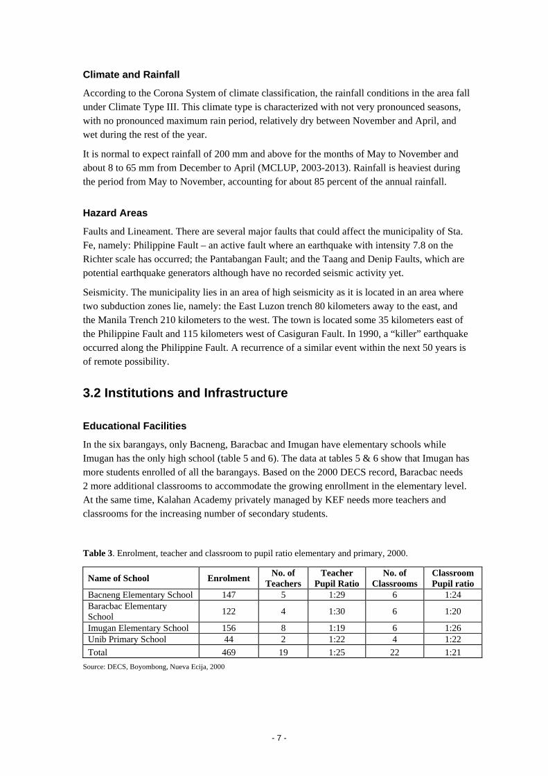
Educational Facilities
In the six barangays, only Bacneng, Baracbac and Imugan have elementary schools while Imugan has the only high school (table 5 and 6). The data at tables 5 & 6 show that Imugan has more students enrolled of all the barangays. Based on the 2000 DECS record, Baracbac needs 2 more additional classrooms to accommodate the growing enrollment in the elementary level. At the same time, Kalahan Academy privately managed by KEF needs more teachers and classrooms for the increasing number of secondary students.
Table 3. Enrolment, teacher and classroom to pupil ratio elementary and primary, 2000.
Name of School Enrolment No. of Teachers
Teacher Pupil Ratio
No. of Classrooms
Classroom Pupil ratio
Bacneng Elementary School 147 5 1:29 6 1:24 Baracbac Elementary School 122 4 1:30 6 1:20
Imugan Elementary School 156 8 1:19 6 1:26 Unib Primary School 44 2 1:22 4 1:22 Total 469 19 1:25 22 1:21
Source: DECS, Boyombong, Nueva Ecija, 2000
- 7 -
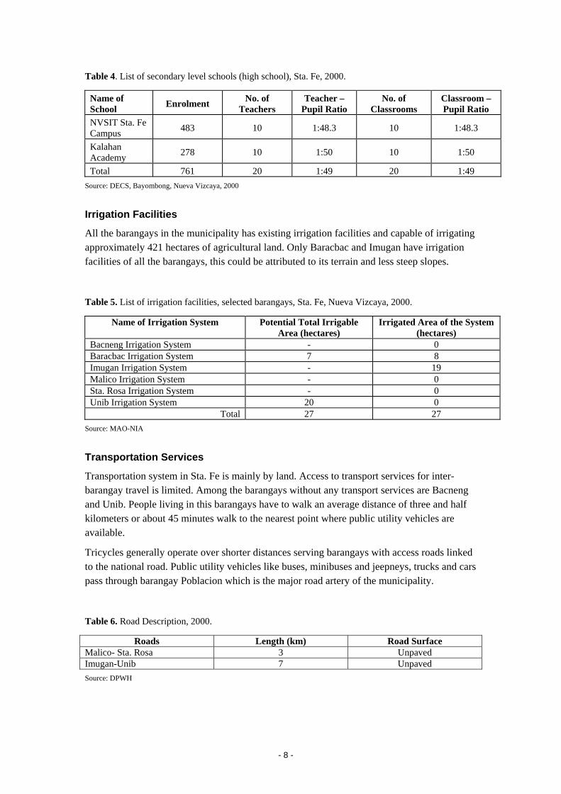
Table 4. List of secondary level schools (high school), Sta. Fe, 2000.
Name of School Enrolment No. of
Teachers Teacher –
Pupil Ratio No. of
Classrooms Classroom – Pupil Ratio
NVSIT Sta. Fe Campus 483 10 1:48.3 10 1:48.3
Kalahan Academy 278 10 1:50 10 1:50
Total 761 20 1:49 20 1:49 Source: DECS, Bayombong, Nueva Vizcaya, 2000
Irrigation Facilities
All the barangays in the municipality has existing irrigation facilities and capable of irrigating approximately 421 hectares of agricultural land. Only Baracbac and Imugan have irrigation facilities of all the barangays, this could be attributed to its terrain and less steep slopes.
Table 5. List of irrigation facilities, selected barangays, Sta. Fe, Nueva Vizcaya, 2000.
Name of Irrigation System Potential Total Irrigable Area (hectares)
Irrigated Area of the System (hectares)
Bacneng Irrigation System - 0 Baracbac Irrigation System 7 8 Imugan Irrigation System - 19 Malico Irrigation System - 0 Sta. Rosa Irrigation System - 0 Unib Irrigation System 20 0
Total 27 27 Source: MAO-NIA
Transportation Services
Transportation system in Sta. Fe is mainly by land. Access to transport services for inter-barangay travel is limited. Among the barangays without any transport services are Bacneng and Unib. People living in this barangays have to walk an average distance of three and half kilometers or about 45 minutes walk to the nearest point where public utility vehicles are available.
Tricycles generally operate over shorter distances serving barangays with access roads linked to the national road. Public utility vehicles like buses, minibuses and jeepneys, trucks and cars pass through barangay Poblacion which is the major road artery of the municipality.
Table 6. Road Description, 2000.
Roads Length (km) Road Surface Malico- Sta. Rosa 3 Unpaved Imugan-Unib 7 Unpaved Source: DPWH
- 8 -
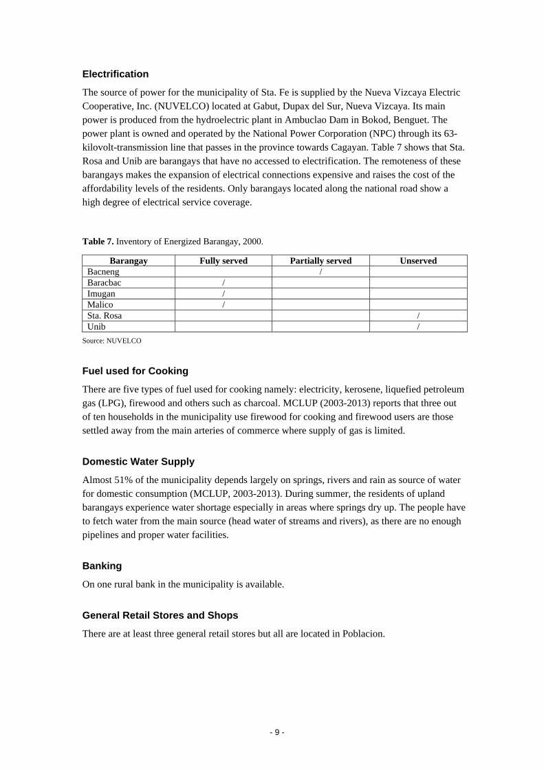
Electrification
The source of power for the municipality of Sta. Fe is supplied by the Nueva Vizcaya Electric Cooperative, Inc. (NUVELCO) located at Gabut, Dupax del Sur, Nueva Vizcaya. Its main power is produced from the hydroelectric plant in Ambuclao Dam in Bokod, Benguet. The power plant is owned and operated by the National Power Corporation (NPC) through its 63-kilovolt-transmission line that passes in the province towards Cagayan. Table 7 shows that Sta. Rosa and Unib are barangays that have no accessed to electrification. The remoteness of these barangays makes the expansion of electrical connections expensive and raises the cost of the affordability levels of the residents. Only barangays located along the national road show a high degree of electrical service coverage.
Table 7. Inventory of Energized Barangay, 2000.
Barangay Fully served Partially served Unserved Bacneng / Baracbac / Imugan / Malico / Sta. Rosa / Unib /
Source: NUVELCO
Fuel used for Cooking
There are five types of fuel used for cooking namely: electricity, kerosene, liquefied petroleum gas (LPG), firewood and others such as charcoal. MCLUP (2003-2013) reports that three out of ten households in the municipality use firewood for cooking and firewood users are those settled away from the main arteries of commerce where supply of gas is limited.
Domestic Water Supply
Almost 51% of the municipality depends largely on springs, rivers and rain as source of water for domestic consumption (MCLUP, 2003-2013). During summer, the residents of upland barangays experience water shortage especially in areas where springs dry up. The people have to fetch water from the main source (head water of streams and rivers), as there are no enough pipelines and proper water facilities.
Banking
On one rural bank in the municipality is available.
General Retail Stores and Shops
There are at least three general retail stores but all are located in Poblacion.
- 9 -
3.3 Socio-Economic Characteristics
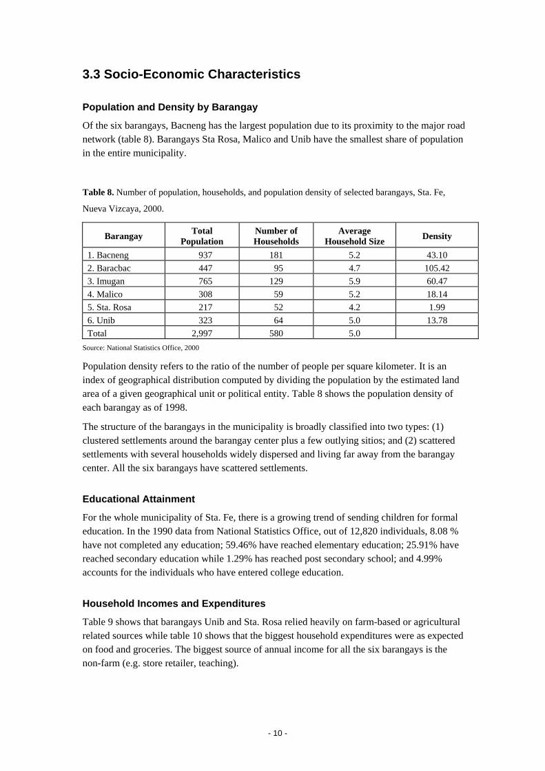
Population and Density by Barangay
Of the six barangays, Bacneng has the largest population due to its proximity to the major road network (table 8). Barangays Sta Rosa, Malico and Unib have the smallest share of population in the entire municipality.
Table 8. Number of population, households, and population density of selected barangays, Sta. Fe,
Nueva Vizcaya, 2000.
Barangay Total Population
Number of Households
Average Household Size Density
1. Bacneng 937 181 5.2 43.10 2. Baracbac 447 95 4.7 105.42 3. Imugan 765 129 5.9 60.47 4. Malico 308 59 5.2 18.14 5. Sta. Rosa 217 52 4.2 1.99 6. Unib 323 64 5.0 13.78 Total 2,997 580 5.0
Source: National Statistics Office, 2000
Population density refers to the ratio of the number of people per square kilometer. It is an index of geographical distribution computed by dividing the population by the estimated land area of a given geographical unit or political entity. Table 8 shows the population density of each barangay as of 1998.
The structure of the barangays in the municipality is broadly classified into two types: (1) clustered settlements around the barangay center plus a few outlying sitios; and (2) scattered settlements with several households widely dispersed and living far away from the barangay center. All the six barangays have scattered settlements.
Educational Attainment
For the whole municipality of Sta. Fe, there is a growing trend of sending children for formal education. In the 1990 data from National Statistics Office, out of 12,820 individuals, 8.08 % have not completed any education; 59.46% have reached elementary education; 25.91% have reached secondary education while 1.29% has reached post secondary school; and 4.99% accounts for the individuals who have entered college education.
Household Incomes and Expenditures
Table 9 shows that barangays Unib and Sta. Rosa relied heavily on farm-based or agricultural related sources while table 10 shows that the biggest household expenditures were as expected on food and groceries. The biggest source of annual income for all the six barangays is the non-farm (e.g. store retailer, teaching).
- 10 -
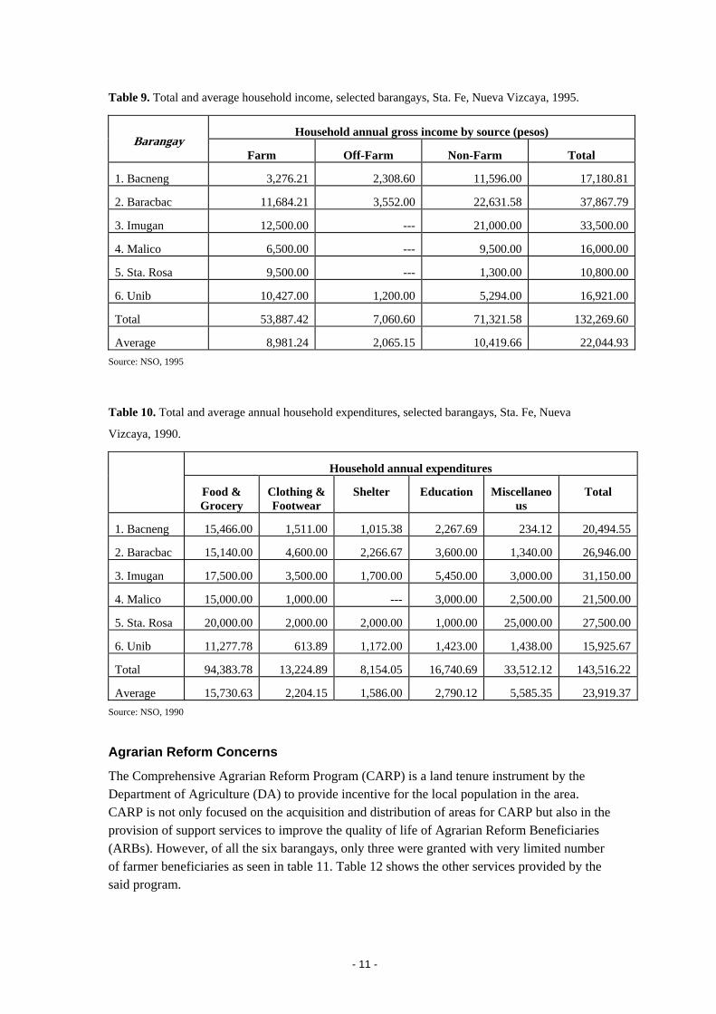
Table 9. Total and average household income, selected barangays, Sta. Fe, Nueva Vizcaya, 1995.
Household annual gross income by source (pesos) Barangay
Farm Off-Farm Non-Farm Total
1. Bacneng 3,276.21 2,308.60 11,596.00 17,180.81
2. Baracbac 11,684.21 3,552.00 22,631.58 37,867.79
3. Imugan 12,500.00 --- 21,000.00 33,500.00
4. Malico 6,500.00 --- 9,500.00 16,000.00
5. Sta. Rosa 9,500.00 --- 1,300.00 10,800.00
6. Unib 10,427.00 1,200.00 5,294.00 16,921.00
Total 53,887.42 7,060.60 71,321.58 132,269.60
Average 8,981.24 2,065.15 10,419.66 22,044.93 Source: NSO, 1995
Table 10. Total and average annual household expenditures, selected barangays, Sta. Fe, Nueva
Vizcaya, 1990.
Household annual expenditures
Food & Grocery
Clothing & Footwear
Shelter Education Miscellaneous
Total
1. Bacneng 15,466.00 1,511.00 1,015.38 2,267.69 234.12 20,494.55
2. Baracbac 15,140.00 4,600.00 2,266.67 3,600.00 1,340.00 26,946.00
3. Imugan 17,500.00 3,500.00 1,700.00 5,450.00 3,000.00 31,150.00
4. Malico 15,000.00 1,000.00 --- 3,000.00 2,500.00 21,500.00
5. Sta. Rosa 20,000.00 2,000.00 2,000.00 1,000.00 25,000.00 27,500.00
6. Unib 11,277.78 613.89 1,172.00 1,423.00 1,438.00 15,925.67
Total 94,383.78 13,224.89 8,154.05 16,740.69 33,512.12 143,516.22
Average 15,730.63 2,204.15 1,586.00 2,790.12 5,585.35 23,919.37 Source: NSO, 1990
Agrarian Reform Concerns
The Comprehensive Agrarian Reform Program (CARP) is a land tenure instrument by the Department of Agriculture (DA) to provide incentive for the local population in the area. CARP is not only focused on the acquisition and distribution of areas for CARP but also in the provision of support services to improve the quality of life of Agrarian Reform Beneficiaries (ARBs). However, of all the six barangays, only three were granted with very limited number of farmer beneficiaries as seen in table 11. Table 12 shows the other services provided by the said program.
- 11 -
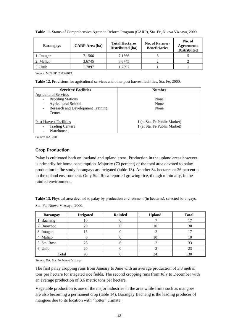
Table 11. Status of Comprehensive Agrarian Reform Program (CARP), Sta. Fe, Nueva Vizcaya, 2000.
Barangays CARP Area (ha) Total Hectares Distributed (ha)
No. of Farmer-Beneficiaries
No. of Agreements Distributed
1. Imugan 7.1566 7.1566 5 5 2. Malico 3.6745 3.6745 2 2 3. Unib 1.7897 1.7897 1 1 Source: MCLUP, 2003-2013
Table 12. Provisions for agricultural services and other post harvest facilities, Sta. Fe, 2000.
Services/ Facilities Number Agricultural Services
- Breeding Stations - Agricultural School - Research and Development Training
Center Post Harvest Facilities
- Trading Centers - Warehouse
None None None
1 (at Sta. Fe Public Market) 1 (at Sta. Fe Public Market)
Source: DA, 2000
Crop Production
Palay is cultivated both on lowland and upland areas. Production in the upland areas however is primarily for home consumption. Majority (70 percent) of the total area devoted to palay production in the study barangays are irrigated (table 13). Another 34-hectares or 26 percent is in the upland environment. Only Sta. Rosa reported growing rice, though minimally, in the rainfed environment.
Table 13. Physical area devoted to palay by production environment (in hectares), selected barangays,
Sta. Fe, Nueva Vizcaya, 2000.
Barangay Irrigated Rainfed Upland Total 1. Bacneng 10 0 7 17 2. Baracbac 20 0 10 30 3. Imugan 15 0 2 17 4. Malico 0 0 10 10 5. Sta. Rosa 25 6 2 33 6. Unib 20 0 3 23
Total 90 6 34 130 Source: DA, Sta. Fe, Nueva Vizcaya
The first palay cropping runs from January to June with an average production of 3.8 metric tons per hectare for irrigated rice fields. The second cropping runs from July to December with an average production of 3.6 metric tons per hectare.
Vegetable production is one of the major industries in the area while fruits such as mangoes are also becoming a permanent crop (table 14). Barangay Bacneng is the leading producer of mangoes due to its location with “hotter” climate.
- 12 -
The palay and corn production in the upland areas of Sta. Fe, while primarily for home consumption, is not enough. Upland barangays import their rice from the lowland areas. Palay production in the lowland areas is sufficient. It markets its surplus to upland areas and neighboring municipalities. Sta. Fe is very sufficient in fruits and vegetables.
Unib, Malico and Sta. Rosa, have limited production of palay and other crops such as vegetable, fruits and root crops due to its topography and irrigation (table 13 and compare table 14).
- 13 -
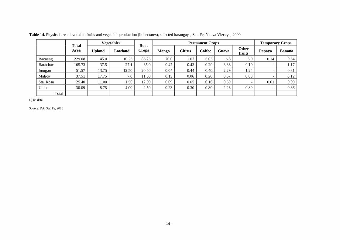
Table 14. Physical area devoted to fruits and vegetable production (in hectares), selected barangays, Sta. Fe, Nueva Vizcaya, 2000.
Vegetables Permanent Crops Temporary Crops Total Area Upland Lowland
Root Crops Mango Citrus Coffee Guava Other
fruits Papaya Banana
Bacneng 229.08 45.0 10.25 85.25 70.0 1.07 5.03 6.8 5.0 0.14 0.54 Baracbac 105.73 37.5 27.1 35.0 0.47 0.43 0.20 3.36 0.10 - 1.17 Imugan 51.57 13.75 12.50 20.60 0.04 0.44 0.40 2.29 1.24 - 0.31 Malico 37.51 17.75 7.0 11.50 0.13 0.06 0.20 0.67 0.08 - 0.12 Sta. Rosa 25.40 11.00 1.50 12.00 0.09 0.05 0.16 0.50 - 0.01 0.09 Unib 30.09 8.75 4.00 2.50 0.23 0.30 0.80 2.26 0.89 - 0.36
Total (-) no data
Source: DA, Sta. Fe, 2000
- 14 -
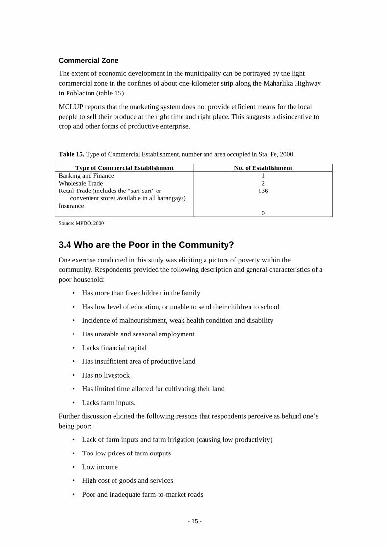
Commercial Zone
The extent of economic development in the municipality can be portrayed by the light commercial zone in the confines of about one-kilometer strip along the Maharlika Highway in Poblacion (table 15).
MCLUP reports that the marketing system does not provide efficient means for the local people to sell their produce at the right time and right place. This suggests a disincentive to crop and other forms of productive enterprise.
Table 15. Type of Commercial Establishment, number and area occupied in Sta. Fe, 2000.
Type of Commercial Establishment No. of Establishment Banking and Finance Wholesale Trade Retail Trade (includes the “sari-sari” or
convenient stores available in all barangays) Insurance
1 2
136
0 Source: MPDO, 2000
3.4 Who are the Poor in the Community? One exercise conducted in this study was eliciting a picture of poverty within the community. Respondents provided the following description and general characteristics of a poor household:
• Has more than five children in the family
• Has low level of education, or unable to send their children to school
• Incidence of malnourishment, weak health condition and disability
• Has unstable and seasonal employment
• Lacks financial capital
• Has insufficient area of productive land
• Has no livestock
• Has limited time allotted for cultivating their land
• Lacks farm inputs.
Further discussion elicited the following reasons that respondents perceive as behind one’s being poor:
• Lack of farm inputs and farm irrigation (causing low productivity)
• Too low prices of farm outputs
• Low income
• High cost of goods and services
• Poor and inadequate farm-to-market roads
- 15 -
• Lack of financial capital
• Limited market
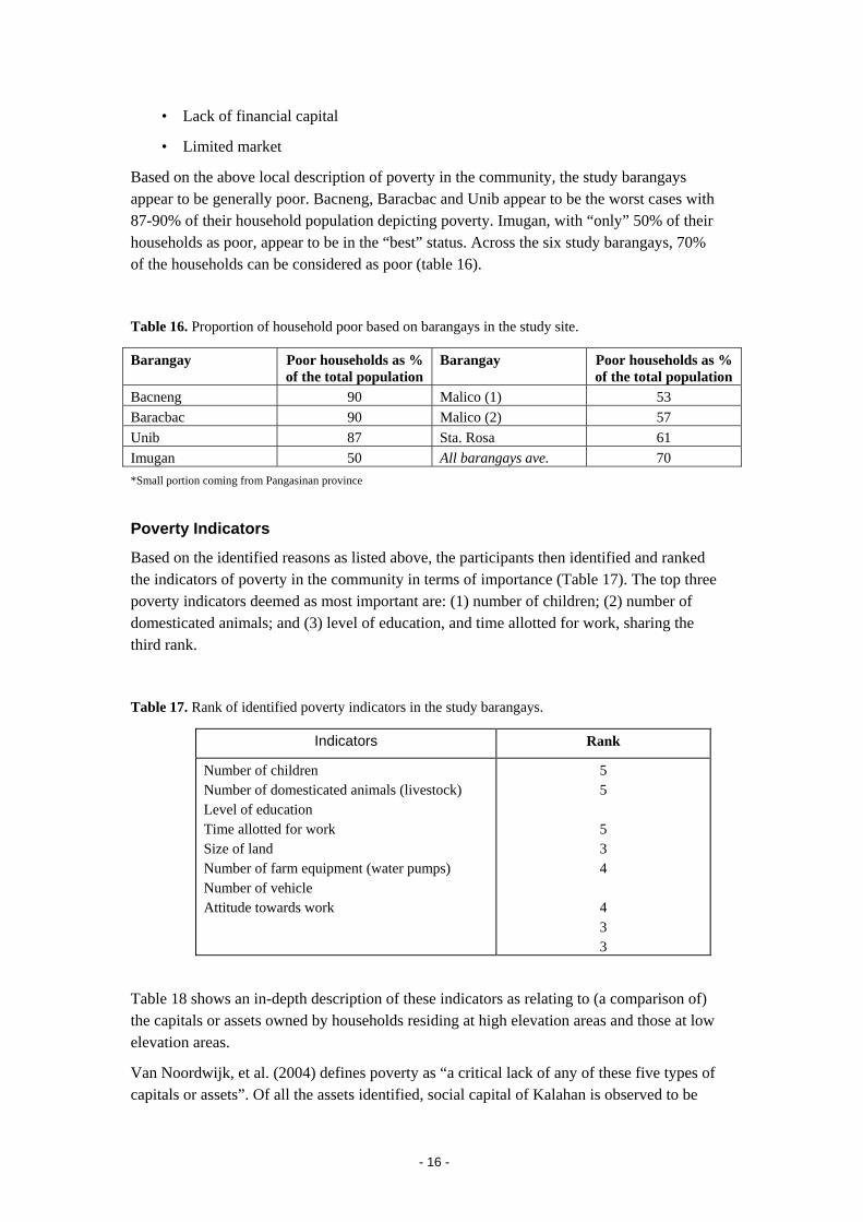
Based on the above local description of poverty in the community, the study barangays appear to be generally poor. Bacneng, Baracbac and Unib appear to be the worst cases with 87-90% of their household population depicting poverty. Imugan, with “only” 50% of their households as poor, appear to be in the “best” status. Across the six study barangays, 70% of the households can be considered as poor (table 16).
Table 16. Proportion of household poor based on barangays in the study site.
Barangay Poor households as % of the total population
Barangay Poor households as % of the total population
Bacneng 90 Malico (1) 53 Baracbac 90 Malico (2) 57 Unib 87 Sta. Rosa 61 Imugan 50 All barangays ave. 70 *Small portion coming from Pangasinan province
Poverty Indicators
Based on the identified reasons as listed above, the participants then identified and ranked the indicators of poverty in the community in terms of importance (Table 17). The top three poverty indicators deemed as most important are: (1) number of children; (2) number of domesticated animals; and (3) level of education, and time allotted for work, sharing the third rank.
Table 17. Rank of identified poverty indicators in the study barangays.
Indicators Rank
Number of children Number of domesticated animals (livestock) Level of education Time allotted for work Size of land Number of farm equipment (water pumps) Number of vehicle Attitude towards work
5 5
5 3 4
4 3 3
Table 18 shows an in-depth description of these indicators as relating to (a comparison of) the capitals or assets owned by households residing at high elevation areas and those at low elevation areas.
Van Noordwijk, et al. (2004) defines poverty as “a critical lack of any of these five types of capitals or assets”. Of all the assets identified, social capital of Kalahan is observed to be
- 16 -
very high and could be seen as strength. They have invested in creating trust bonded by traditional rules and customs to protect both their lives and the environment.
The following are the general analysis and observations where other capitals or assets are found limited to the communities:
a) Access to physical infrastructures such as markets, farm-to-market roads, transportation, and irrigation facilities are necessary for farm-based livelihood such as those of the Kalahan. Table 9 validates the result of poor physical infrastructures necessary for a productive farm business in the community. Because of this, the household relies more on non-farm sources of income, such as overseas remittances (MCLUP, 2003-2013):
Farm-to-market roads in major crop producing barangays especially in the uplands are often impassable during the rainy season. Inefficiency of marketing, high spoilage and rejects add to the woes of the farmers.
Low farm production in the study barangays can also be explained by:
• Farmers’ heavy dependence on inorganic fertilizers and chemical pesticides, resulting to soil infertility due to increasing acidity, and to water and environmental pollution;
• Most farmers still adopt traditional farming methods and practices that result to low production. Despite the regular provision of technology demonstrations, farmer adoption of innovated farm technologies is still very slow;
• The problem on large investment or capitalization required to adopt new technology is further aggravated by limited access to credit. As such, farmers resort to usurers and traders who extended credit to them.
• No market outlets within the area so farmers do not have alternative except to sell their produce to middlemen and some traders who control or dictate price.
b) Financial assets are difficult in both low and high elevation areas, but farmers in the low elevation areas have more credit options. It was also observed that having livestock or domesticated animals is a determining factor of poverty in the area due to a strong adherence to tradition, e.g. cow, pig or carabao is used for burial or wedding rituals.
c) Poverty is also linked to education. The community believes that individuals of higher education level have better opportunities to be employed in nearby towns and cities or abroad. Unfortunately, elementary schools in the barangays are inadequate and this could have contributed to the municipality’s eight percent who have not completed any education (see page 11 under Educational Attainment). Access to and level of education are better only at lower elevation.
d) Access to social infrastructures like hospitals, health centers and schools is insufficient. Despite of this, it was observed that the residents are healthy with access to clean drinking water and good sanitation.
The above results from the FGD are more or less consistent with the secondary data and information collected. Although communities or households both in high and low elevation areas share almost the same natural resources or capital, it can be said that in general
- 17 -

households at lower elevation barangays (i.e. Imugan, Bacneng and Baracbac) are better off than those at the higher elevation areas.
- 18 -
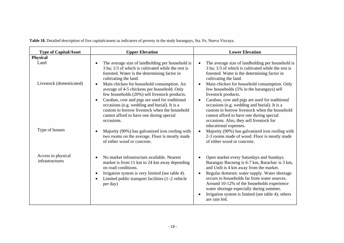
Table 18. Detailed description of five capitals/assets as indicators of poverty in the study barangays, Sta. Fe, Nueva Vizcaya.
Type of Capital/Asset Upper Elevation Lower Elevation Physical Land Livestock (domesticated) Type of houses Access to physical
infrastructures
• The average size of landholding per household is
3 ha; 1/3 of which is cultivated while the rest is forested. Water is the determining factor in cultivating the land.
• Main chicken for household consumption. An average of 4-5 chickens per household. Only few households (20%) sell livestock products.
• Carabao, cow and pigs are used for traditional occasions (e.g. wedding and burial). It is a custom to borrow livestock when the household cannot afford to have one during special occasions.
• Majority (90%) has galvanized iron roofing with two rooms on the average. Floor is mostly made of either wood or concrete.
• No market infrastructure available. Nearest
market is from 11 km to 24 km away depending on road conditions.
• Irrigation system is very limited (see table 4). • Limited public transport facilities (1–2 vehicle
per day)
• The average size of landholding per household is
3 ha; 1/3 of which is cultivated while the rest is forested. Water is the determining factor in cultivating the land.
• Main chicken for household consumption. Only few households (5% in the barangays) sell livestock products.
• Carabao, cow and pigs are used for traditional occasions (e.g. wedding and burial). It is a custom to borrow livestock when the household cannot afford to have one during special occasions. Also, they sell livestock for educational expenses.
• Majority (90%) has galvanized iron roofing with 2-3 rooms made of wood. Floor is mostly made of either wood or concrete.
• Open market every Saturdays and Sundays.
Barangay Bacneng is 6-7 km, Baracbac is 3 km, and Unib is 4 km away from the market.
• Regular domestic water supply. Water shortage occurs to households far from water sources. Around 10-12% of the households experience water shortage especially during summer.
• Irrigation system is limited (see table 4); others are rain fed.
- 19 -
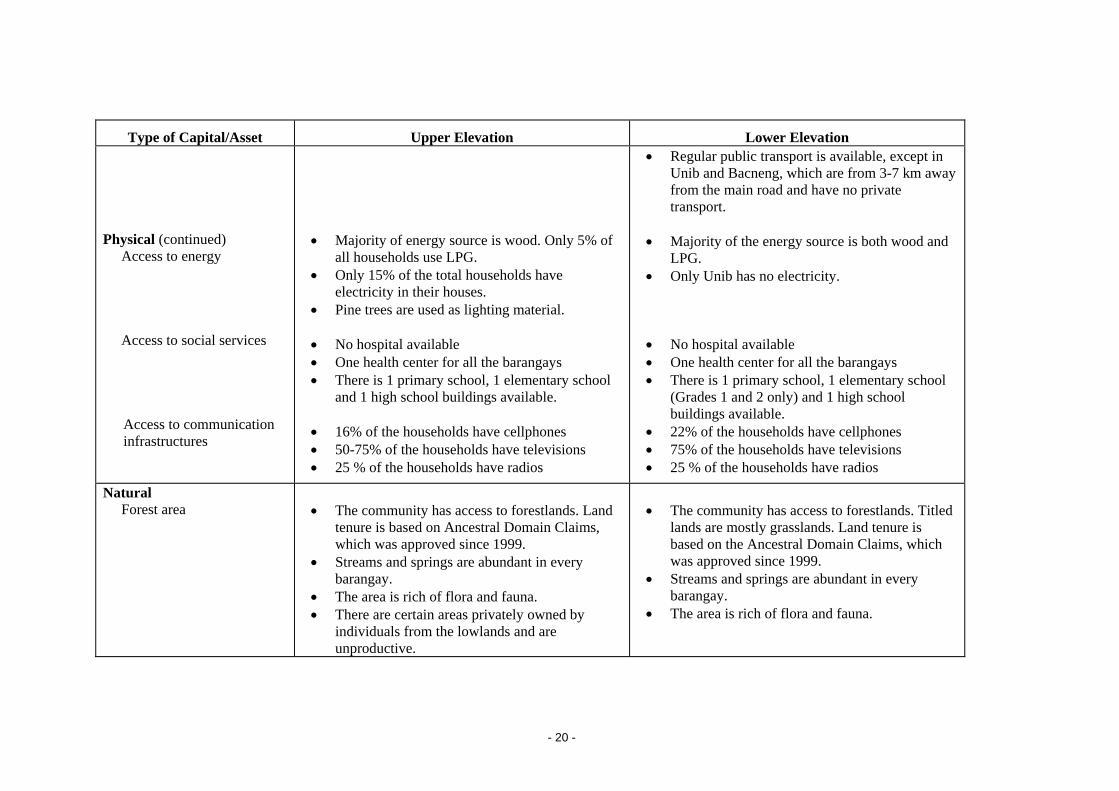
Type of Capital/Asset Upper Elevation Lower Elevation Physical (continued) Access to energy Access to social services
Access to communication infrastructures
• Majority of energy source is wood. Only 5% of
all households use LPG. • Only 15% of the total households have
electricity in their houses. • Pine trees are used as lighting material. • No hospital available • One health center for all the barangays • There is 1 primary school, 1 elementary school
and 1 high school buildings available. • 16% of the households have cellphones • 50-75% of the households have televisions • 25 % of the households have radios
• Regular public transport is available, except in Unib and Bacneng, which are from 3-7 km away from the main road and have no private transport.
• Majority of the energy source is both wood and
LPG. • Only Unib has no electricity. • No hospital available • One health center for all the barangays • There is 1 primary school, 1 elementary school
(Grades 1 and 2 only) and 1 high school buildings available.
• 22% of the households have cellphones • 75% of the households have televisions • 25 % of the households have radios
Natural Forest area
• The community has access to forestlands. Land
tenure is based on Ancestral Domain Claims, which was approved since 1999.
• Streams and springs are abundant in every barangay.
• The area is rich of flora and fauna. • There are certain areas privately owned by
individuals from the lowlands and are unproductive.
• The community has access to forestlands. Titled
lands are mostly grasslands. Land tenure is based on the Ancestral Domain Claims, which was approved since 1999.
• Streams and springs are abundant in every barangay.
• The area is rich of flora and fauna.
- 20 -
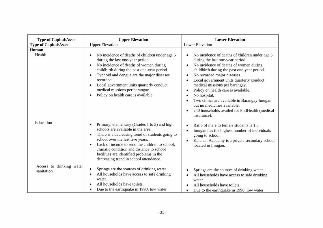
Type of Capital/Asset Upper Elevation Lower Elevation Type of Capital/Asset Upper Elevation Lower Elevation Human Health Education
Access to drinking water sanitation
• No incidence of deaths of children under age 5
during the last one-year period. • No incidence of deaths of women during
childbirth during the past one-year period. • Typhoid and dengue are the major diseases
recorded. • Local government units quarterly conduct
medical missions per barangay. • Policy on health care is available. • Primary, elementary (Grades 1 to 3) and high
schools are available in the area. • There is a decreasing trend of students going to
school over the last five years. • Lack of income to send the children to school,
climatic condition and distance to school facilities are identified problems in the decreasing trend in school attendance.
• Springs are the sources of drinking water. • All households have access to safe drinking
water. • All households have toilets. • Due to the earthquake in 1990, low water
• No incidence of deaths of children under age 5
during the last one-year period. • No incidence of deaths of women during
childbirth during the past one-year period. • No recorded major diseases. • Local government units quarterly conduct
medical missions per barangay. • Policy on health care is available. • No hospital. • Two clinics are available in Barangay Imugan
but no medicines available. • 240 households availed for PhilHealth (medical
insurance). • Ratio of male to female students is 1:3 • Imugan has the highest number of individuals
going to school. • Kalahan Academy is a private secondary school
located in Imugan. • Springs are the sources of drinking water. • All households have access to safe drinking
water. • All households have toilets. • Due to the earthquake in 1990, low water
- 21 -
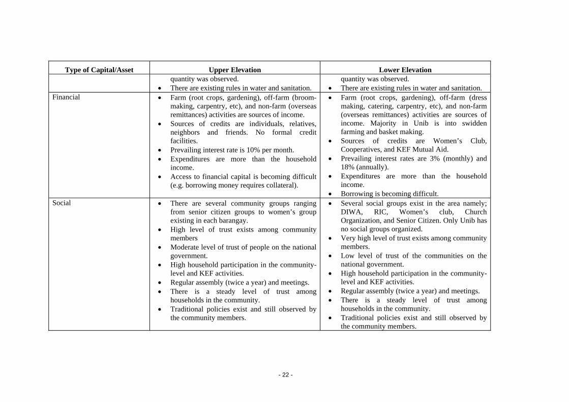
Type of Capital/Asset Upper Elevation Lower Elevation quantity was observed.
• There are existing rules in water and sanitation. quantity was observed.
• There are existing rules in water and sanitation. Financial
• Farm (root crops, gardening), off-farm (broom-making, carpentry, etc), and non-farm (overseas remittances) activities are sources of income.
• Sources of credits are individuals, relatives, neighbors and friends. No formal credit facilities.
• Prevailing interest rate is 10% per month. • Expenditures are more than the household
income. • Access to financial capital is becoming difficult
(e.g. borrowing money requires collateral).
• Farm (root crops, gardening), off-farm (dress making, catering, carpentry, etc), and non-farm (overseas remittances) activities are sources of income. Majority in Unib is into swidden farming and basket making.
• Sources of credits are Women’s Club, Cooperatives, and KEF Mutual Aid.
• Prevailing interest rates are 3% (monthly) and 18% (annually).
• Expenditures are more than the household income.
• Borrowing is becoming difficult. Social
• There are several community groups ranging from senior citizen groups to women’s group existing in each barangay.
• High level of trust exists among community members
• Moderate level of trust of people on the national government.
• High household participation in the community-level and KEF activities.
• Regular assembly (twice a year) and meetings. • There is a steady level of trust among
households in the community. • Traditional policies exist and still observed by
the community members.
• Several social groups exist in the area namely; DIWA, RIC, Women’s club, Church Organization, and Senior Citizen. Only Unib has no social groups organized.
• Very high level of trust exists among community members.
• Low level of trust of the communities on the national government.
• High household participation in the community-level and KEF activities.
• Regular assembly (twice a year) and meetings. • There is a steady level of trust among
households in the community. • Traditional policies exist and still observed by
the community members.
- 22 -
One important aspect that was observed during the conduct of the FGD is when the participants were asked the proportion of the communities who are considered as poor. Most of the participants were reluctant to express that they are poor when in fact they have very rich culture and customs.
The overall observations where poverty dimensions co-vary with degradation (Van Noordwijk, et al., 2004) in Kalahan are:
(1) People living in remote forest environments are rich in all aspects of environmental services, but are poor because of lack of public services (health and education) and has low income but with enough to eat. Lack of or underdeveloped public services such as good roads, physical market infrastructures, schools and health centers are considered critical poverty traps. These particularly exist in the communities at upper elevation. Investments on these kinds of services are needed to remove these traps.
(2) People who lived in landscapes where rehabilitation starts to be successful have prospects of reducing all dimensions of poverty. – Functional landscape is perceived by the communities at the lower elevation as an important means to reduce the different dimensions of poverty. This observation is more expounded in the succeeding sub-section.
3.5 People's Perception of Environmental Services and Its Potential Impact on Poverty and Livelihood
Forest and trees are part of the Kalahan people’s lives. They know already the ecosystem services that their forests can provide and these are:
• Clean and regular flow of water;
• Biodiversity (“nadumaduma” in Ikalahan dialect);
• Ecotourism (e.g. Imugan Falls); and
• Carbon sequestration
Currently, ecotourism sites exist in Imugan (i.e. Imugan Falls, Tuy-Ub Park), Malico (i.e. Villaverde Trail), Unib-Kayapa (i.e. mountain trekking), and Sta. Rosa (i.e. camping area).
Apart from these, they have identified the following environmental services that their community or households are willing to market if buyers are available:
• Water
• Microclimate (thru ecotourism)
• Pollination and seed dispersal
• Medicinal plants
They concluded that the main effort to be undertaken to enhance and maintain the environmental services in the area is reforestation. Rewards could be in the form of financial assistance, trust and public services such as hospital and medical services, school buildings and farm-to-market roads. Since swidden farming or “kaingin” is part of their lives and not
- 23 -

considered as an employment, the potential rewards from their ES provision could contribute greatly to their living condition. Majority of the communities in the higher elevation perceive rewards as a means to increase access to investment funds for potentially profitable activities such as tailoring, livestock raising and food processing. They also have identified potential forest-based enterprises including charcoal production, mushroom production e.g. shiitake and oyster mushroom, orchids production, furniture making, spices, medicinal plants, resins, essential oils, beekeeping, handicrafts, and food processing from endemic wild fruits (Appendix 3).
The communities strongly expressed their assurance that they will further enhance the ecosystem services to have a continued flow of rewards. However, the only buyers they are aware of are from the lowlands who will buy only farm goods and products, e.g. vegetables, mushrooms and root crops. The communities however think that environmental services such as microclimate, pollination and carbon storage, could not be marketed, since they do not have the capacity and knowledge to negotiate with these group of buyers.
Moreover, education played a key role in inculcating ecological values to the community and thus homogenizing their view of the environment (Albano, 2005). Through the Kalahan Academy, basic ecology is offered to the students while Ecology Training Centre of KEF is meant for all the resident farmers and to nearby communities.
3.6 Potential Constraints on Effective Utilization of Environmental Services
Before the establishment of KEF, lands in the higher elevation barangays (Malico and Sta. Rosa) were titled to lowlanders. Because of this, communities in that area were not able to use and cultivate the limited productive land in the highlands; rather they are constrained in maximizing the ecosystem services in that area. They are hoping that the private owners will soon sell their lands to KEF, and that KEF will have funds to purchase the titled land in order to return them back to the communities.
Whatever forms of rewards, the poor people in the barangays have trust with the KEF and the local government units to use the rewards wisely. The only concern of the communities is delivering wrong information as a result of weak cooperation of the various stakeholders, which may create negative thoughts.
- 24 -
Conclusion Poverty in Kalahan is linked to the lack of access and/or underdeveloped public services such as market infrastructures, education and health services. Investments on these infrastructures and services are needed to uplift the living conditions in the area. However, to enable to provide these needs, marketing of environmental services from their landscape is seen as an opportunity. Poverty is most prevalent in barangay Unib, Sta. Rosa and Malico.
- 25 -
References Albano, A. 2005: Forest enterprises and sustainable livelihoods: A case study of Kalahan
Educational Foundation (KEF). MSc. Thesis. ANU. 81p.
Balisacan, A. M. and E. M. Pernia, 2002: What else besides growth matters to poverty reduction? ADB Economics and Research Department Policy Brief Series, Number 5. Manila, ADB.
ESCAP, 2000: State of the environment in Asia and the Pacific – report. Bangkok, ESCAP.
ESCAP, 2005: State of the environment in Asia and the Pacific- economic growth and sustainability report. Bangkok, ESCAP.
Foundation for Philippine Environment, 2001: Ikalahan community development projects. FPE. Manila. Pp.36.
KEF, 2003: Kalahan forest service project proposal for RUPES action research, Kalahan Educational Foundation, unpublished. 14p.
MCLUP, 2003-2013: Municipal comprehensive land use plan of Sta. Fe, Nueva Vizcaya. Pp 225.
NEDA, 2003: Philippines progress report on the millennium development goals. Manila. NEDA.
van Noordwijk, M., F.J. Chandler & T.P. Tomich, 2004: An introduction to the conceptual basis of RUPES: rewarding upland poor for the environmental services they provide. ICRAF-Southeast Asia, Bogor.
- 26 -
Appendix 1. Participatory Poverty Assessment Methodology for RUPES Sites
Present status of people's Poverty and Livelihood Situation
The multi-dimensional measure of poverty suggests that poverty is due to lack to adequate access to five critical capitals: physical, natural, human, social, and financial. The following check list of questions aims to analyze people's present access to these various capitals and how has it been changing over time.
1. Physical capital
a. Land
- Average size of land holding per household according to land types (e.g. irrigated land, non-irrigated land).
- Land tenure situation?
- Proportion of land with irrigation facility?
b. Livestock
- Proportion of households in your group that rear livestock?
- Main livestock and average size of holding per family?
- Do you sell livestock or livestock products?
- What is the trend regarding household's possession of livestock?
- Has the role of livestock in people's livelihood increased or decreased over time?
c. House Type
Roof - concrete or thatch roof?
Number of rooms in a house?
Floor type - cement, tile soil?
d. Access to Physical Infrastructure
- Market infrastructure? Market sheds, wholesale and retail markets?
- Length of good roads, distance from motorable roads?
- Domestic water supply system?
- Irrigation system?
- Public transport facilities?
- Number of households with private transport facilities - e.g. car, motorbike, etc.)
e. Access to Energy
- Main sources of cooking fuel.
- Number (proportion) of households with access to electricity?
- Use of LPG gas?
- Use of Kerosene?
- 27 -
a. Access to Social Infrastructure
- Number of schools, colleges, vocational institutions.
- Number of hospitals, health centres.
b. Access to Communication Infrastructure
- Number of households with home telephone, TV, radio, computers.
- Public telephone and computer facilities.
- Local newspapers and their subscription.
2. Natural capital
- Forest area? Quality of forest cover?
- Households' access to forest?
- Forest ownership - government, private, community owned?
- Any mines in your area?
- Watershed Area?
- Recreational sites?
- Flora and fauna species?
- Number of springs, rivers and other water sources in your area?
- Any other natural resource?
- Has the access to natural resources improved or decreased over time?
- How have policies regarding natural resources changed in the last 25 years?
3. Human capital - education, health, drinking water and sanitation.
Health
- Number of children under age 5 who died in your community during the last one-year period? (Also get the total number of children under age 5 in the community)
- Number of women in your community who died during childbirth during the past one year?
- Incidence of HIV/AIDS in community?
- Incidence of Malaria and other major diseases?
- Problems in health care? (shortage of doctors and nurses, availability of medicines, lack of hospitals and health centres, etc.)
- Trends and policies regarding heath care system in the past 25 years?
Education
- Proportion of children in the community who complete primary education.
- Ratio of boys and girls in primary schools.
- 28 -
- Ratio of boys and girls in secondary schools.
- Ratio of boys and girls in tertiary schools.
- Problems in education?
- Trends in education and major changes in education policies in the past 25 years?
Access to drinking water and sanitation
- What are the sources of drinking water?
- Proportion of households with access to safe drinking water?
- How many households in your community have their own toilets?
- Trends and policies regarding access to safe drinking water and sanitation?
4. Financial capital
- Sources of cash income (farm income, wages and salaries, pensions, remittances, etc.)
- Average level of household's savings?
- Number of banks and other financial institutions in your area?
- What are the major sources of your credit? (rural money lenders, banks, relatives, etc.)
- Prevailing interest rates for credits from formal and informal sources?
- Expenditure pattern (food, clothing, education, health care, recreation, etc)
- Trends and policies regarding people's access to financial capital? Are households saving more or less? Has it become easier for households to borrow money? Is the interest rate increasing or decreasing over time?
5. Social capital
- How many community groups does an average household belong to?
- Level of trust of community members on each others (5=very high, 1= very low)
- Level of trust of people on government (5=very high, 1=very low)
- Households' participation to community level activities? (high, medium, low) Do they contribute labor? Cash contribution?
- Traditional rules, policies, and their implementation.
- Number of ethnic groups and cultural diversity?
- Is the level of trust, household's participation in community groups, number of community groups, etc, increasing or decreasing over time?
- How have policies influenced social capita over time? Have government and donor programs undermined social capital?
In addition to access to five critical capitals, the incidence of risks and shocks make people vulnerable to poverty. It is important to understand the nature of such risks and people's
- 29 -
coping mechanisms for the design and implementation of effective poverty reduction policies.
Risks and vulnerability - what are major risks/shocks that drive people to poverty? e.g. bird flu, AIDS, crop failure, drought, flooding, earthquakes, etc.
Empowerment (Voice) - Are people in your community able to influence government policies? Are they represented in political institutions and other decision-making bodies?
Coping strategies - how do people cope with shocks - take loans, seek help from family and friends (social capital), and migrate to other places.
Government safety nets - old age allowance, pensions, allowance for disabled people?
- 30 -
Appendix 2. Natural resources development program and Agro-forestry rules
I. SWIDDEN FARMING PERMIT
A. Any person who wants to prepare a new farm clearing (uma) must get a permit from the Agro-forestry Office. A fee of five (5.00) pesos shall be collected for the permit.
B. Only residents of the Kalahan Reserve shall be granted a swidden farming permit.
C. Any person who wants to cultivate land outside his/her own claim must obtain a written permission from the claimant. This practice shall be discouraged.
D. Whenever a newly cleared area is to be burned, the owner must maintain a fireline with a width of 10 meters. This should be inspected first by a forest guard before the clearing is burned. Violation of this regulation shall be penalized for causing forest fires.
E. Clearing in reserved areas, parks, watersheds, sanctuaries, research sites shall not be allowed.
F. Forest guards neglecting their duties with regards to these policies shall be subjected to administrative sanctions.
G. Penalties
1. Anybody clearing or extending clearings in restricted areas shall be fined PhP500 and will be required to repair the damage or shoulder the equivalent cost of said repair.
2. Anybody clearing without a permit shall be fined 250 pesos. Clearing any area other than the inspected site is considered clearing without a permit.
II. TREE CUTTING PERMIT
H. Any person who wants to cut any tree must first get a permit from the Agro-forestry office.
I. The permit shall identify the tree to be cut and the time frame within which the tree should be cut and removed from the forest.
J. A “minute” of the lumber needed shall be required from the applicants. This must be approved by the Barangay Captain of the area where the tree is to be used.
K. Tree cutting permits shall only be issued upon approval of the Agro-Forestry office and upon payment of the corresponding permit fee as to the following purposes:
L. Profit sharing from the permit fees to be collected shall be implemented based on a 40-60% scheme between the barangay and the KEF respectively.
- 31 -
M. No tree shall be cut without the proper mark of the Forester responsible for the Forest Improvement Technology (FIT) activities under the Natural Resources Development Program. No permit shall be issued to cut any tree not so marked. This includes salvage trees or sanitation cutting. The mark will indicate the direction to fell. The foresters shall avoid issuing permits to be implemented during the rainy season when forest damage may be severe.
N. Penalties
1. First offense: any person violating these regulations shall be fined 400 pesos fore every tree cut. Any lumber, slab or other products obtained will be confiscated.
2. Second offense: Violators shall be fined 400 pesos and shall be denied a cutting permit in the future. Any lumber, slab, or other products obtained shall be confiscated.
III. CHAINSAW REGISTRATION AND OPERATIONS
O. All chainsaws operating within the Kalahan Reserve must be registered annually with the Agro-forestry Office. A copy of the registration will be furnished to the CENRO. A charge of 200 pesos registration will be paid by the owner/operator per year.
P. A maximum of 14 chainsaws shall only be allowed to operate within the Kalahan Reserve. Replacements or new chainsaws shall not be allowed.
Q. The entry or operations of unregistered chainsaws in the Kalahan Reserve is absolutely forbidden.
R. A forest charge will be collected from the chainsaw owners/operators equivalent to 15% of the lumber price generated purposely for forest improvement.
S. No lumber shall be brought outside the Kalahan Reserve. Accepting orders, selling, or donating lumbers to any person, group, or institution outside the Reserve is prohibited.
T. PENALTIES: Any person found violating any of these regulations will be fined as follows:
1. First offense: Any person who accepts lumber orders to donate or sell to persons outside of the Kalahan Reserve will be fined 500 pesos.
2. Second offense: Permanent cancellation of chainsaw registration.
3. Any chainsaw owner or operator who fails to pay the proper forest charges within 90 days shall be suspended from the operation of his chainsaw until his obligation is paid in full.
4. Operations of unregistered chainsaws shall be fined 500 pesos and an additional fine of 400 pesos for every tree cut.
- 32 -
5. Failure to renew chainsaw registration in 2 months after the expiration of its registration shall be a ground for cancellation of the permit to operate.
IV. FISHING
U. Residents of the Kalahan Reserve are free to do fishing by traditional means but chemicals and electricity shall not be allowed under any circumstances. Non-residents are strictly forbidden to fish within the Kalahan Reserve.
V. Penalties: Violators of this policy shall be fined as follows:
1. Use of illegal fishing methods will be fined 400 pesos per violator and all fishing supplies and/or equipment will be confiscated.
2. Non-residents who fish within the Kalahan Reserve shall be charged with illegal entry in addition to being punished for illegal fishing.
W. Use of “natural tuba” in halap may be allowed provided that the waterflow be returned immediately after fishing.
V. FOREST FIRES
X. Limited prescribed burning in grazing lands may be allowed provided that the interested party obtains a permit describing the specific area to be burned and the date and time of burning. Only a forester shall be allowed to issue this permit. A charge of five pesos will be paid.
Any fire which occurs which is not covered by a swidden permit or grazing land burning permit shall be considered as a forest fire.
Y. Penalties
1. Any person who causes a forest fire shall pay the proper remuneration for all persons involved in putting out the fire.
2. The guilty party must pay or repair all damages to houses, fruit trees, forest trees, etc.
3. The guilty party must reforest the burned area.
4. The guilty party must pay a fine of 500 pesos.
VI. QUARRYING
Z. Quarrying in the riverbeds shall be supervised by the Barangay concerned in cooperation with the Agro-Forestry Office.
AA. Clearing stone from the road shall not be considered quarrying.
VII. ILLEGAL ENTRY
BB. Persons who are not bonafide residents of the Kalahan Reserve are not entitled to harvest or utilize the natural resources within the Kalahan Reserve.
- 33 -
CC. Penalties: Any person violating this regulation shall be fined a minimum of 500 pesos or a maximum of 5,000 pesos and any and all harvested forest products shall be confiscated. Said violation may also be reported to the DENR or PNP with a request that violators be prosecuted according to law.
VIII. SANCTUARIES AND WATERSHEDS
DD. The KEF has designated two Watershed-Sanctuaries within the Kalahan Reserve. All plant and animal resources found therein are under protection. Hunting, catching animals and harvesting plants are prohibited. Gathering of limited samples for research purposes may be permitted subject to permission from the KEF and Barangay authorities.
EE. Barangays are encouraged to identify additional watersheds within their jurisdiction. FIT may be practiced inside unless the watershed is also declared to be a sanctuary.
FF. Penalties
1. Violations of this regulation shall be punished with a fine of at least 1,000 pesos but not more than 10,000 pesos depending on the severity of the violation. Any and all products or resources obtained by the violator shall be confiscated.
2. Attempts to violate this regulation shall be considered as consummated violations.
IX. HUNTING
GG. Seasonal hunting is allowed outside the sanctuaries during the following periods:
Animals: July to August
Birds: November to December
The night bird catching “Akik” has not regulation provided to cover this issue. A larger body should reconsider this to resolve issues.
HH. Penalties
Any person found violating this regulation shall be fined 500 pesos plus confiscation of harvest and hunting equipment.
X. LAND CLAIMS
II. Each bonafide resident family may claim a maximum of ten (10) hectares of private land within the Kalahan Reserve. Each claimant must make and implement a land use plan of which 25% shall be dedicated to environmental protection and register the same with the Agro-forestry Office. Each claimant shall be issued a copy his/her claim.
JJ. Any claimant who does snot begin implementation of his/her land use plan within a period of five (5) years from its registration may have his/her claim reduced in size.
- 34 -
KK. Sale, mortgage or transfer of possession of any land claim to other bonafide residents of the Kalahan Reserve shall require the approval of the Board of Trustees (BOT) through the NRDP Agro-forestry Office which shall maintain an up-to-date record of all such claims.
LL. Sale, mortgage or transfer of possession of any land claim to any person who is not a bonafide resident of the Kalahan reserve shall not be allowed and the KEF will not recognize such transactions.
MM. All surveys, including relocation and subdivision, shall be done by the Agro-forestry Office of the KEF. The Agro-forestry office shall charge the amount of 800 pesos for the first day and 600 pesos for each succeeding day needed for the resurvey to cover costs of labor in the field, equipment, transportation, materials and registration. Disputes over boundaries must be discussed first among the concerned claimants and referred to the Tribal Elders and Barangay officials. Failure of the accomplishment of the survey due to unclarify boundary disputes shall be charged against the claimant requesting resurvey.
XI. MISCELLANEOUS POLICIES
NN. Tree planting: All barangays covered by the Kalahan Reserve are encouraged to initiate and actively participate to the regular tree planting activities in their respective barangays.
OO. Banned Species: Cutting and or gathering of the banned or endangered plant or animal species inside the Kalahan Reserve is strictly prohibited.
PP. Certification of lumber origin: A Certification of Lumber Origin may be issued by the Agro-Forestry Office to individuals who wish to move lumber from a house within the Reserve to some location outside of the Reserve provided that the lumber are originally sourced from within the Kalahan Reserve with proper permits.
QQ. Ban of chemical pesticides: In keeping with the KEF policy of environmental cooperation in all undertakings that involve the natural resources, no chemical pesticides be used within the Reserve. It was understood that use of these, will have adverse effects on the soil, biodiversity, and human health.
The effects of thrown pesticides in the river, the guilty party is obliged to pay the damage on lives and properties.
RR. Collection of fines and fees: All fines must be collected within three (3) months from the date they were promulgated. Fines not paid within three months shall be charged an interest of 3% per month. For the share of the barangays from all fines and fees, it shall be given every 12th month of the year.
SS. Disposition of fines: KEF and the Barangay concerned shall share fines. The 75% shall go to the apprehending party and 25% shall be given to the other party. When an individual apprehends the violator, he/she shall
- 35 -
receive 50% of the fine and the KEF and the concerned barangay shall be entitled to 25% each.
TT. Other actions: Violations may be referred to higher authorities for action if violators fail to comply.
UU. Lumber price: P6.00 per board foot.
VV. Orchid gathering moratorium: Moratorium on gathering orchids in all parts of the Reserve shall be imposed on January 1, 2002. Training on orchid production shall also be conducted.
WW. Effectivity: February 1, 2001.
Approved this day of December 5, 2000 at Imugan, Sta. Fe, Nueva Vizcaya.
- 36 -
Appendix 3. Potential forest enterprises
Forest-based enterprises identified in Kalahan are the following (based on Albano, 2005):
Carbon sequestration
KEF has ongoing project with the World Agro-forestry Center wherein they are looking for the potential for KEF to engage into the carbon sequestration market created through the Kyoto Protocol. KEF already has more than 10 years time series data about the carbon sequestration potential of indigenous tree species found in their forests. Initial computation of costs and benefits for this potential enterprise however, indicates that income from carbon sequestration alone is not sufficient to cover the investment cost. It should be complemented by revenue from the trees or crops to be planted. KEF is considering the intercropping of cacao, madre de cacao (kakawate), banana, and vanilla, together with indigenous species. Cacao, kakawate, and the indigenous trees will be responsible for carbon sequestration. At the same time, cacao can also be a cash crop together with banana and vanilla. The indigenous trees will be for the biodiversity. A feasibility study needs to be conducted to look further into the technical and financial feasibility of such enterprise.
Watershed payments
KEF is also considering the potential of getting paid for protecting their forests, which is a watershed for irrigation for lowland farmers and for the Magat Dam, one of the country’s largest dams.
Water bottling
Drinking water is overflowing and being wasted in the Kalahan Reserve while it is valued almost the same as motor oil in cities and urban areas. All it takes is to bottle the water and get certification from the Bureau of Food and Drugs (BFAD) and this is what KEF is currently doing. KEF has received assistance to establish a water bottling enterprise and the construction of water purification system is ongoing. They plan to sell bottled water under the ‘Mountain Fresh’ brand name.
Eco-tourism
As identified earlier in the strengths and opportunities, KEF could potentially engage in eco-tourism given its cold climate, green landscape, diverse forests, and historically significant areas (e.g. Spanish trail, World War II battlefield). Currently, it has the capacity to accommodate up to 30 people. It has to develop other related infrastructure and network with tourism agents and travel agencies. They are planning to target quality tourism – nature lovers, mountain climbing hobbyists, and families – instead of quantity, which they may not be able to handle or regulate.
Food processing, organic vegetable production, and mushroom production
Currently, the most promising enterprises for KEF are its current enterprises: the food processing center, the organic vegetables, and mushroom production which already have developed and increasing market and where KEF already has technical capacity.
- 37 -
Working Paper Series
2003-2005
1. Eco-Certification as an Incentive to Conserve Biodiversity in Rubber Smallholder Agroforestry Systems: A Preliminary Study
2. RUPES: A Review of Initiatives from Developed Countries
3. Development Assistance to Upland Communities in The Philippines
4. Forest Area Rationalization in Indonesia: A Study on The Forest Resource Condition and Policy Reform
5. Environmental Service “Payments”: Experiences, Constraints and Potential in The Philippines
6. Assessing the Livelihood Benefits to Local Communities from the Profafor Carbon Sequestration Project, Ecuador
7. An Introduction to the Conceptual Basis of RUPES
8. Review of Developments of Environmental Services Markets in Sri Lanka
9. Rewards for Environmental Services in the Philippines Uplands: Constraints and Opportunities for Institutional Reform
10. Case Study of the Maasin Watershed: Analyzing the Role of Institutions in a Watershed-Use Conflict
11. Rapid Agrobiodiversity Assessment (RABA): A tool to capture the understanding and knowledge of stakeholders on the benefits of agrobiodiversity
12. Rewarding Upland Farmers for Environmental Services: Experience, Constraints, and Potential in Vietnam
13. Institutional Constraints and Opportunities in Developing Environmental Service Markets: Lessons from Institutional Studies on RUPES in Indonesia
14. Review of Developments of Environmental Services Markets in Indonesia
15. RUPES Typology of Environmental Service Worthy of Reward
2007
1. Report on the Self-Evaluation Study of RUPES
- 38 -

A Future Harvest Centre supported by the CGIAR


