53
THE STUDY FOR ESTABLISHMENT OF DIGITAL TOPOGRAPHIC MAPS IN GEORGIA Final Report Summary PASCO CORPORATION March 2008
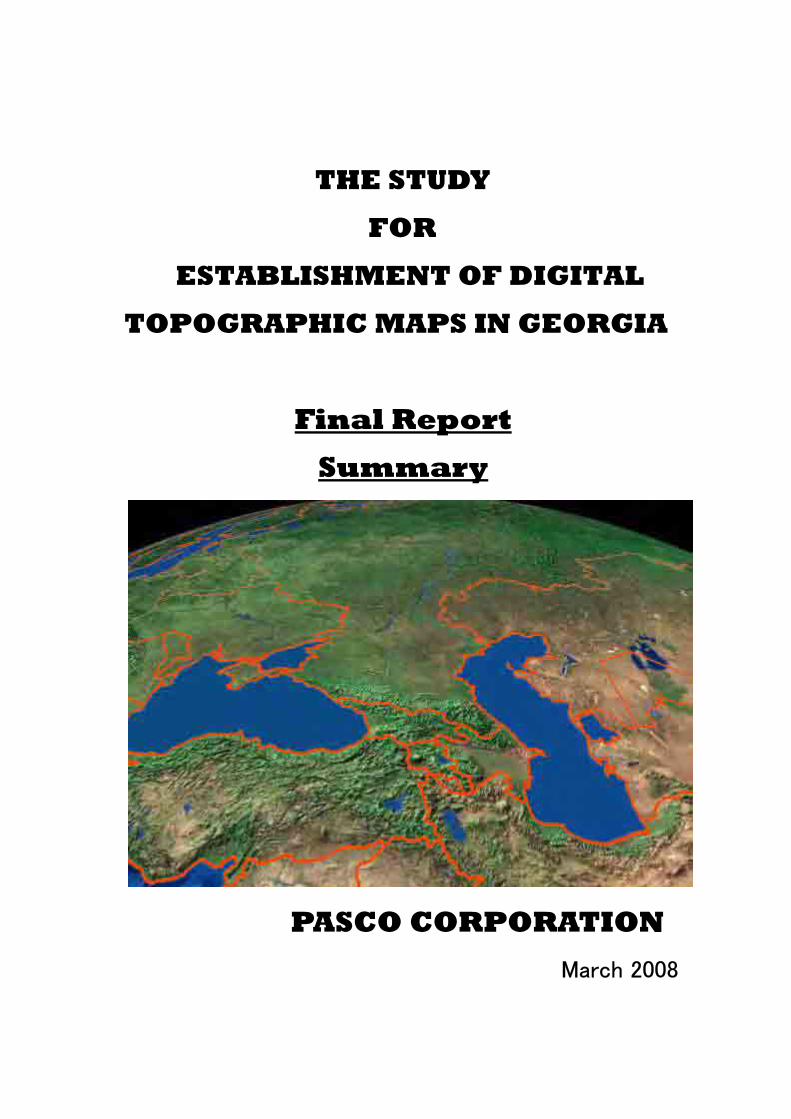
THE STUDY
FOR
ESTABLISHMENT OF DIGITAL
TOPOGRAPHIC MAPS IN GEORGIA
Final Report
Summary
PASCO CORPORATION
March 2008

CURRENCY EQUIVALENTS
Currency Unit = Georgian Lari (GEL) US$1.00 = 1.5450 (exchange rate February 18 , 2008 )

PREFACE
In response to a request from the Government of Georgia, the
Government of Japan decided to conduct a study on The Study for
Establishment of Digital Topographic Maps in Georgia and
entrusted to the study to the Japan International Cooperation
Agency (JICA).
JICA selected and dispatched a study team headed by Mr.
Hisashi MORI of PASCO Corporation and consists of PASCO
Corporation between April, 2005 and February, 2008.
The team held discussions with the officials concerned of
the Government of Georgia, and conducted field surveys at the
study area. Upon returning to Japan, the team conducted further
studies and prepared this final report.
I hope that this report will contribute to the promotion of
this project and to the enhancement of friendly relationship
between our two countries.
Finally, I wish to express my sincere appreciation to the
officials concerned of the Government of Georgia for their close
cooperation extended to the study.
March 2008
Eiji HASHIMOTO,
Deputy Vice President
Japan International Cooperation
Agency

Mr. Eiji HASHIMOTO Vice President for Japan International Cooperation Agency
LETTER OF TRANSMITTAL
Dear Mr. Hashimoto, We are greatly honored to submit to you the final report on “The Study for Establishment of Digital Topographic Maps in Georgia” that was implemented based on the contract with your Agency. This report summarized the progress of the study and results of the works over the three years from fiscal year 2005. Pasco Corporation carried out this study from April,2005 to March, 2008, and the outcomes from the works include aerial photographs on the scale of 1/40,000, topographic maps on the scale of 1/50,000 , the digital topographic data with GIS database and GIS model systems.
In this report, we also elaborate on approaches to effective use of the topographic data in various fields of decision-making and are convinced that it will contribute to the promising socio-economic development of Georgia. On behalf of the study team in Pasco Corporation, I would like to express my deepest gratitude to the Geology-Cartography and Geodesy Service and the organizations concerned in the Government of Georgia for their close cooperation extended to the Study Team. Finally, I wish to convey my sincere appreciation to the officials in JICA, Geographical Survey Institute, the Ministry of Land Infrastructure and Transport, the Ministry of Foreign Affairs and the Embassy of Japan in the republic of Azerbaijan for providing us with suggestive advices and appropriate directions that have been given to us during the implementation of the project.
March, 2008
The Study for Establishment of Digital Topographic Maps in Georgia Leader of the Study Team Hisashi Mori
Contents CHAPTER 1. INTRODUCTION..............................................................................................- 1 -
1.1. Background and progress of the Study............................................................- 1 - 1.2. Objectives and Study area .............................................................................- 2 - 1.3. Outline of the Study and Outcomes.................................................................- 3 -
1.3.1. Contents of the study.......................................................................................- 3 - 1.3.2. Outcomes of the Study ....................................................................................- 4 -
1.4. Composition of the Study Team Members ......................................................- 5 - CHAPTER 2. BASIC POLICY OF THE STUDY....................................................................- 6 -
2.1. Overall Policy..................................................................................................- 6 - 2.2. Basic Policy in Technical Aspects ...................................................................- 6 - 2.3. Basic Policy of Technology Transfer ..............................................................- 6 -
CHAPTER 3. OUTLINE OF THE STUDY..............................................................................- 8 - 3.1. Overall component of the Study and its flow..................................................- 8 - 3.2. Work items and process in each year ..............................................................- 9 - 3.3. Study items and their results in three years ...................................................- 10 -
3.3.1. Survey standards and map specifications ......................................................- 10 - 3.3.2. Aerial photography........................................................................................- 12 - 3.3.3. Ground control point survey .........................................................................- 13 - 3.3.4. Aerial triangulation .......................................................................................- 13 - 3.3.5. Field Completion...........................................................................................- 15 - 3.3.6. Updating of the existing maps.......................................................................- 16 - 3.3.7. Digital plotting for newly created maps ........................................................- 17 - 3.3.8. Field completion............................................................................................- 18 - 3.3.9. Map symbolization........................................................................................- 18 - 3.3.10. Creation of GIS database...............................................................................- 18 - 3.3.11. Creation of GIS MODEL Systems ................................................................- 20 - 3.3.12. Dissemination of Geographic Information and Building a Sharing System .- 28 - 3.3.13. Workshop ......................................................................................................- 33 - 3.3.14. Seminar .........................................................................................................- 34 - 3.3.15. Execution of Technical Transfer....................................................................- 36 - 3.3.16. Equipments installed .....................................................................................- 37 -
CHAPTER 4. ISSUES TO BE CONSIDERED IN FUTURE ................................................- 39 - 4.1. Counter part organizational Development.....................................................- 39 - 4.2. Strategy to maintain map of remaining area..................................................- 39 -

4.3. Issues related to promotion of data use in future...........................................- 40 - 4.3.1. Establishment of data sales system ...............................................................- 40 - 4.3.2. Popularization of GIS application .................................................................- 42 -

List of Figures
Figure 1.2.1 Study Area..................................................................................................- 2 - Figure 3.1.1 Conceptual diagram of the Study and flow................................................- 8 - Figure 3.2.1 Work items and process in each year ........................................................- 9 - Figure 3.3.1 Sheet design of new printed map ............................................................- 12 - Figure 3.3.2 Observation of GCP in the field...............................................................- 13 - Figure 3.3.3 Allocation of control points in each block...............................................- 14 - Figure 3.3.4 Output files cutting off into the format of newly designed map sheet.....- 15 - Figure 3.3.5 Scene in preliminary photo-interpretation ...............................................- 15 - Figure 3.3.6 Updating existing maps using digitized existing map data......................- 16 - Figure 3.3.7 Areas for updating the existing maps.......................................................- 17 - Figure 3.3.8 Summit Evolution for digital plotting ..................................................- 17 - Figure 3.3.9 Sample of draft map with descriptions about corrections........................- 18 - Figure 3.3.10 Work Flow of GIS data Creation ...........................................................- 19 - Figure 3.3.11 7 Kinds of Data set composition ............................................................- 19 - Figure 3.3.12 Participation of Coordinating Committee Members and Creation of GIS
Model Systems ........................................................................................................- 20 - Figure 3.3.13 Location and Guide Areas of Each GIS Model......................................- 21 - Figure 3.3.14 Potential Area for Settlement Expansion and Alignment.......................- 22 - Figure 3.3.15 Forest Conservation Status between 1993 and 2005..............................- 23 - Figure 3.3.16 Highly Vulnerable Forest in the Model Area .........................................- 24 - Figure 3.3.17 Possible Extension of Tourist Route ......................................................- 25 - Figure 3.3.18 Potential Land for Agricultural Development........................................- 26 - Figure 3.3.19 Ratio of Students per Teacher in each District of Tbilisi .......................- 27 - Figure 3.3.20 Concept of Dissemination and Sharing of Geographic Information......- 28 - Figure 3.3.21 Cases of Dissemination of Topographic Data........................................- 29 - Figure 3.3.22 Tasks for Building Data Sharing System ...............................................- 31 - Figure 3.3.23 Concept to help figure out the System Image ........................................- 32 - Figure 3.3.24 Ideal Steps for Realization of Data Sharing Systems.............................- 32 - Figure 3.3.25 Presentation by the Study Team ..............................................................- 35 - Figure 3.3.26 Participants attended the Seminar ...........................................................- 35 - Figure 4.3.1 Diagram of a Model Showing the Scheme of Selling Mapping Data......- 41 - Figure 4.3.2 Dissemination methods for wider use of GIS ..........................................- 42 - Figure 4.3.3 Examples of Thematic layers...................................................................- 44 -
List of Tables
Table 1.3.1 Items of the work in the Study.....................................................................- 3 - Table 1.3.2 Outcomes of the Study from the Study........................................................- 4 - Table 1.4.1 Members of the Study Team ......................................................................- 5 - Table 2.3.1 List of crucial items in the OJT and its aim.................................................- 7 - Table 3.3.1 Basic structure of symbolization ...............................................................- 11 - Table 3.3.2 Specification of the aircraft and aerial camera ..........................................- 12 - Table 3.3.3 Specification of the film scanning.............................................................- 12 - Table 3.3.4 Specification of the film scanning.............................................................- 13 - Table 3.3.5 Specification of the film scanning.............................................................- 14 - Table 3.3.6 GIS Model Area and Theme for each GIS Model .....................................- 20 - Table 3.3.7 Sales pricing of topographical map ...........................................................- 29 - Table 3.3.8 Comparison of Sales Amount in 3 Cases...................................................- 30 - Table 3.3.9 Comparison of Sales Amount in 3 Cases of Unit Price .............................- 30 - Table 3.3.10 Program of Workshop ..............................................................................- 33 - Table 3.3.11 Program of the Seminar ...........................................................................- 34 - Table 3.3.12 List of installed equipments.....................................................................- 37 - Table 4.3.1 List of Free Software for GIS utilization .................................................- 43 -

List of Abbreviations
CAD Computer-Aided Design
DEM Digital Elevation Model
DGC Department of Geodesy and Cartography
DTM Digital Terrain Model
EPNR Environment Protection and Natural Resources (The name of the ministry)
GCGS Geology-Cartography and Geodesy Services
GCP Ground Control Point
GIS Geographic Information System
GPS Global Positioning System
JICA Japan International Cooperation Agency
MSL Mean Sea level
MST Multi-sensor Triangulation
NGO Non-Governmental Organization
OJT On-the-Job Training
SGC Service of Geodesy and Cartography
SIA Spatial Information Agency
TIN Triangulated Irregular Network
UNDP United Nations Development Program
UTM Universal Transverse Mercator
WGS 84 World Geodetic System 1984
The Study for Establishment of Digital Topographic Maps in Georgia Chapter 1
Introduction
Chapter 1. 1.1.
Introduction
Background and progress of the Study
Necessity for the Project Georgia is currently carrying forward national development and democratization, and the country is in absolute need for foreign assistance in shifting to a market-based economy, developing social infrastructure and environmental protection, supporting refugees, etc. through land reform. More concretely, accurate ascertainment of geographical information which underlies the national land is among top priority issues. However, in the aspect of national basic map, there has been no revision conducted so as to keep the topographic maps up to date since 1980s during the former Soviet era, and the obsolete geographical information has been one of the hindrances to planning and formation of national development programs and smooth implementation of relevant projects. Therefore, it is a common understanding that immediate construction of national spatial basic data (geographical information) reflecting the most recent situation and digitization of map data for easy use are vital for smooth realization of all sorts of national development plans. Accordingly, the government of Georgia submitted an official request to the government of Japan in January 2004, which has successfully led to the implementation of the Project.
Progress of the new National Development Plan and promotion of shift to the market-based economy by the reformed governmentGeorgia underwent a drastic political change in November 2003, when the people’s culminated frustration toward the stagnant economy and the then government’s rampant corruption ousted the former president Eduard Shevardnadze. In consequence, Mikheil Saakashvili, one of the key figures of the reform group, was selected as a new president, initiating a new administration in January 2004. Today, the new president is carrying forward reorganization of the government structure along with formulation of a new National Development Plan. The Policy Framework 1998-2000 formulated by the Ministry of Finance of Georgia posts the following as the nation’s economic policy goals: promotion of shift to the market-based economy, strengthening of the fiscal infrastructure, privatization of large state-owned companies or non-agricultural land, land reform, tax reform, etc. Meantime, the Georgian government underwent a ministrial reshuffle in October 2005, immediately after the initiation of the Project, and the former counterpart, i.e. the
- 1 -
The Study for Establishment of Digital Topographic Maps in Georgia Chapter 1
Introduction
Department of Geography and Cartography (hereinafter referred to as “DGC”), was drastically restructured and downsized. The counterpart, the former DGC, was taken over to the SGC (Service of Geodesy and Cartography) in 2006,and moreover the SGC affiliated with the Geology Service that belongs the same ministry as the SGC in the end of 2007. As a result, the counterpart again changed the name to GCGS
(Geology-Cartography and Geodesy Service) from SGC and widen the function of its service with the increase in staff member.
1.2. Objectives and Study area
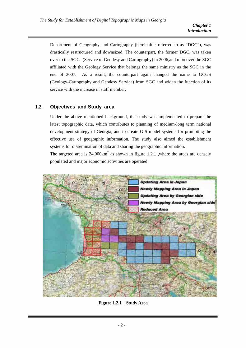
Under the above mentioned background, the study was implemented to prepare the latest topographic data, which contributes to planning of medium-long term national development strategy of Georgia, and to create GIS model systems for promoting the effective use of geographic information. The study also aimed the establishment systems for dissemination of data and sharing the geographic information. The targeted area is 24,000km2 as shown in figure 1.2.1 ,where the areas are densely populated and major economic activities are operated.
Figure 1.2.1 Study Area
- 2 -
The Study for Establishment of Digital Topographic Maps in Georgia Chapter 1
Introduction
1.3.
1.3.1.
Outline of the Study and Outcomes
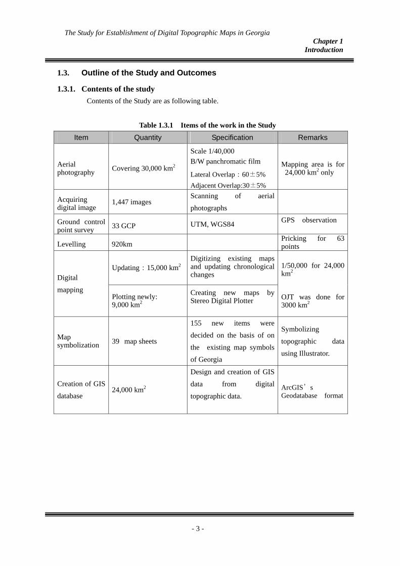
Contents of the study Contents of the Study are as following table.
Table 1.3.1 Items of the work in the Study
Item Quantity Specification Remarks
Aerial photography Covering 30,000 km2
Scale 1/40,000 B/W panchromatic film
Lateral Overlap:60±5% Adjacent Overlap:30±5%
Mapping area is for 24,000 km2 only
Acquiring digital image
1,447 images Scanning of aerial photographs
Ground control point survey 33 GCP UTM, WGS84 GPS observation
Levelling 920km Pricking for 63 points
Updating:15,000 km2Digitizing existing maps and updating chronological changes Digital
mapping Plotting newly: 9,000 km2
Creating new maps by Stereo Digital Plotter
1/50,000 for 24,000 km2
OJT was done for 3000 km2
Map symbolization 39 map sheets
155 new items were decided on the basis of on the existing map symbols of Georgia
Symbolizing topographic data using Illustrator.
Creation of GIS database
24,000 km2
Design and creation of GIS data from digital topographic data.
ArcGIS’s Geodatabase format
- 3 -
The Study for Establishment of Digital Topographic Maps in Georgia Chapter 1
Introduction
GIS Model database
6 fields; Urban development, Forest management, Environmental protection, Tourism promotion, Agricultural land use, Educational facility
Creating Databases from each thematic map
GIS Model for Urban Development
GIS Model for Forest Management and
Reforestation GIS Model for Facilitating Environmental
Protection
GIS Model for Facilitating Environmental
Protection GIS Model for Optimization of Agricultural
Land Use
GIS Model systems
GIS Model for Contribution to Information
of Educational Improvement
GIS analysis models :1 set each
GIS Model data base :1 set each
Manual for operating models
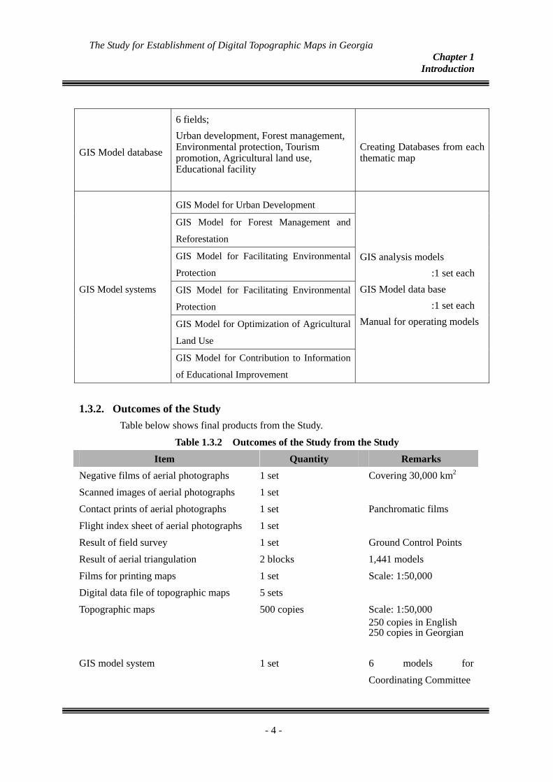
1.3.2. Outcomes of the Study Table below shows final products from the Study.
Table 1.3.2 Outcomes of the Study from the Study Item Quantity Remarks
Negative films of aerial photographs 1 set Covering 30,000 km2
Scanned images of aerial photographs 1 set Contact prints of aerial photographs 1 set Panchromatic films Flight index sheet of aerial photographs 1 set Result of field survey 1 set Ground Control Points Result of aerial triangulation 2 blocks 1,441 models Films for printing maps 1 set Scale: 1:50,000 Digital data file of topographic maps 5 sets Topographic maps 500 copies Scale: 1:50,000
250 copies in English 250 copies in Georgian
GIS model system 1 set 6 models for
Coordinating Committee
- 4 -

The Study for Establishment of Digital Topographic Maps in Georgia Chapter 1
Introduction
Inception report 10 copies of English 10 copies of Russian
Interim report 10 copies of English 10 copies of Georgian
As per request of the counterpart, Report in Georgian was prepared instead of Russian
Progress report 10 copies of English 10 copies of Georgian
Draft final report : Main report : Summary
10 copies of English 10 copies of Georgian 10 copies of English 10 copies of Georgian
Final report : Main report : Summary
10 copies of English 10 copies of Georgian 10 copies of English 10 copies of Georgian
1.4. Composition of the Study Team Members
The members of the Study Team and their dispatch from Japan to Georgia for the Study are as follows; Table 1.4.1 Members of the Study Team
TITLE NAME
Team Leader Fujio ITO
Team Leader , Deputy Leader , Project Adviser Hisashi MORI
Supervisor for aerial Photography Timo JARVINEN
Supervisor for control Survey Yutaka NAKADA
Supervisor for field verification 1 Sadao MATSUMOTO
Supervisor for field verification2 , Supervisor for map symbolization Toshinori OTSU Supervisor for revision of existing map Supervisor for field verification 2 Supervisor for construction GIS model system
Akihiro SUGITA
Supervisor for construction GIS model system Hidetoshi KAKIUCHI
Supervisor for map symbolization Takashi SHIMONO
Supervisor for digital plotting and compilation Minori ONAKA
Supervisor for GIS Database Awadh Kishor SAH
Interpreter Makiko UEHARA
Coordinator Kensuke KIMURA
- 5 -
The Study for Establishment of Digital Topographic Maps in Georgia Chapter 2
Basic policy of the Study
Chapter 2. 2.1.
2.2.
2.3.
Basic policy of the Study
Overall Policy
・ Support the body that acts as a coordinator in cooperation with related organizations.
・ Pay a careful attention to transfer the technologies in view of promotion for disseminating topographic data and of construction of data sharing.
・ Make an effort to promote the wider use of geographic information.
Basic Policy in Technical Aspects
・ Adopt a new survey standard and coordinate system ・ Bring a innovated methods in conducting the field verification ・ Attach great importance to efficient creation of digital data in mapping ・ Attach importance to the technical transfer in creating GIS database ・ Construct GIS model systems for encouraging positive use of geographic
information
Basic Policy of Technology Transfer
Main emphasis was placed on establishment of firm skills in producing digital topographic data and on methods of data sharing and dissemination to widen the GIS users. Items of technology transfer through the OJT and points stressed are as follows (Table2.3.1).
- 6 -

The Study for Establishment of Digital Topographic Maps in Georgia Chapter 2
Basic policy of the Study
Table 2.3.1 List of crucial items in the OJT and its aim
Items Contents Point stressed Effects on skill building for the
counterpart Selection of GCP’ And GPS observation
Ground ControlPoint Survey and analysis
Analysis of GPS data
Practice of systematic observation
・Reconstruction of the geodetic control point network, and promotion of use of GPS data in digital photogrammetry
Geometric correction d Geo-referencing anDigitization of
existing map Skill for digitizing
Knowledge on tolerable error in geometric correction
・ Effective utilization of equipment and apparatus of the Department of Geography and Cartography, and revitalization of engineers
Aerial triangulation
Methods of aerial triangulation
・Operation of software for digital aerial
・Evaluation on the results from aerial triangulation
・ Improvement of productivity through application of digital technology
Stereo plotting Stereo digital plotting and compilation Compilation of digital
data
・ Practical operation of digital plotting
・Method for cleaning of digital data
・ Improvement of productivity and cost reduction through application of digital technology
Map symbolization Symbolization and Preparation of printing film Creation of digital
printing data
・Operation of publishing software
・Displacement of symbol and discontinuity of featuring lines
・Realization of producing printed 1/50,000 maps
Design of structure of database
Creation of GIS databases
Creating GIS data
・Understanding GIS ・ Operation of GIS software
・Popularization and promotion of GIS in assisting formulation of priority projects in the national development plan, and establishment of viability of the GCGS
Application for GIS
Preparation of thematic data and Applying GIS model
・Choosing necessary data・Creation of GIS models
and practical use
・ Elevation of the degree of contribution of GCGS and improvement of its position through practical application of GIS to priority fields
- 7 -
The Study for Establishment of Digital Topographic Maps in Georgia Chapter 3
Outline of the Study
Chapter 3. 3.1.
Outline of the Study
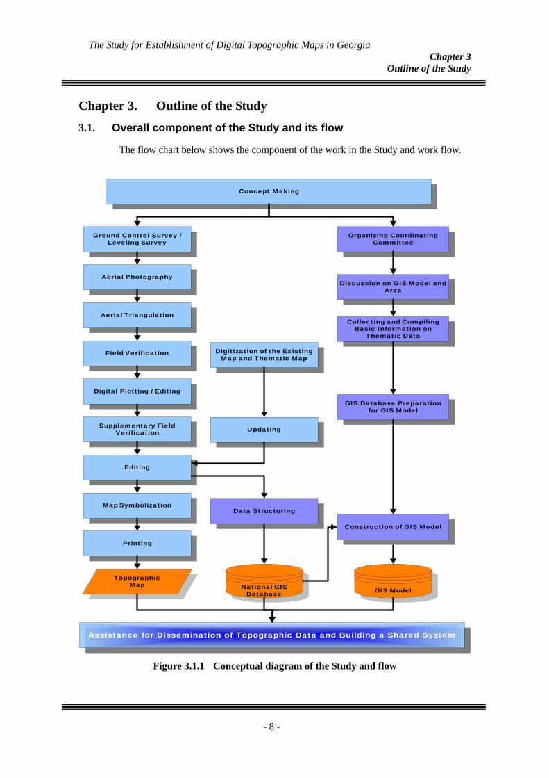
Overall component of the Study and its flow
The flow chart below shows the component of the work in the Study and work flow.
Concept Making
Ground Control Survey /Leveling Survey
Aerial Photography
Aerial Triangulation
Field Verification
Digital Plotting / Editing
Supplementary FieldVerification
Editing
Digitization of the ExistingMap and Thematic Map
Updating
Data StructuringMap Symbolization
TopographicMap National GIS
Database
Organizing CoordinatingCommittee
Discussion on GIS Model andArea
Collecting and CompilingBasic Information on
Thematic Data
GIS Database Preparationfor GIS Model
GIS Model
Printing
Construction of GIS Model
Assistance for Dissemination of Topographic Data and Building a Shared System
Figure 3.1.1 Conceptual diagram of the Study and flow
- 8 -
The Study for Establishment of Digital Topographic Maps in Georgia Chapter 3
Outline of the Study
3.2.
Year
F.Y.
Nov
April
Dec
Nov
May
April
July
Aug
July
Feb
1st Yea
rFi
scal Y
ear (
2005
-06)
2nd Y
ear
Fisca
l Yea
r (20
065-0
7)3rd
Yea
rFi
scal Y
ear (
2007
-08)
Marc
hJu
neSe
ptOc
tFe
bJan
Aug
Oct
May
June
JanM
arch
Aug
Sept
Feb
Nov
Dec
April
May
June
July
Mon
thJan
Dec
Sept
Oct
Marc
h
Digit
al Plo
tting a
ndCo
mpila
tion (
includ
inged
iting o
f exis
ting m
aps)
Vectorization ofexisting Topographic
map data
Field
Surve
y
Aeria
lTr
iangu
lation
work
s
Creat
ion of
the D
EMs
and c
ontou
r line
s Su
pplem
ental
Comp
ilatio
n
Digi
tal Pl
otting
and
Comp
ilatio
n (inc
luding
editin
g of e
xistin
g map
s)
F
ield
Verif
icatio
n
Vecto
rizati
on of
exist
ing To
pogra
phic
map d
ata
Symb
olizat
ion of
the T
opog
raphic
map
sSy
mboli
zatio
n of th
eTo
pogra
phic
maps
Symbolization ofthe Tographic
maps
Field
Comp
letion
Printing
Confi
rmati
onof
data
forpri
nting
Assistance in building a system for marketinggeographic informaiton
Crea
tion o
fGI
S Data
base
Crea
tion o
f GIS
Mod
el Sy
stems
Creat
ion of
GIS
Mod
elSy
stems
Holding Technology TransferSeminar and Workshop
Creation of theFinalReport
Work
in G
eorgi
aW
ork in
Japa
n
Symbolization ofthe Topographic
maps
Crea
tion o
fGI
S M
odel
Syste
ms
Creat
ionof
GIS
Datab
ase
Crea
tion
of GI
SDa
tabase
Crea
tion o
fGI
S M
odel
Syste
ms
Creat
ionof
GIS
Datab
ase
Creat
ion of
film fo
rrep
roduc
tion
Creat
ion of
data
files
Takin
gAe
rial
Photo
-gra
phs
IC/R
IT/R
P/RDF
/RF/R
Assistance in building a system for sharing
geographic informaiton
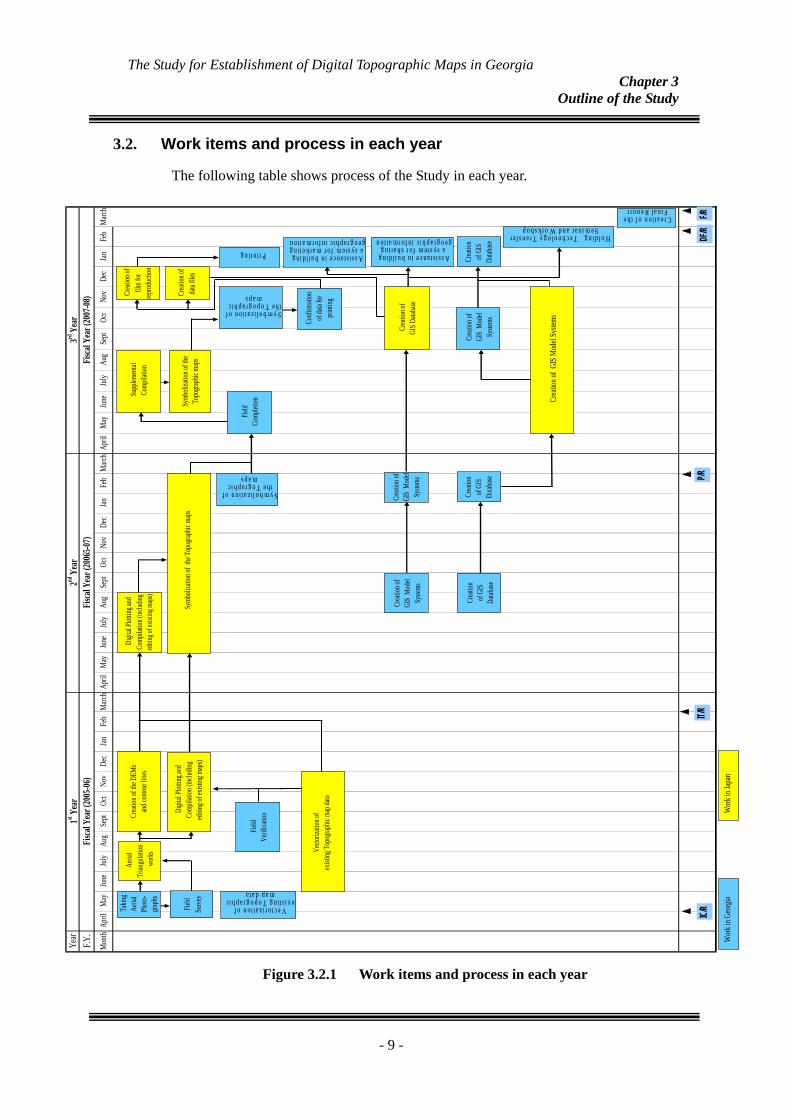
Work items and process in each year
The following table shows process of the Study in each year.
Figure 3.2.1 Work items and process in each year
- 9 -
The Study for Establishment of Digital Topographic Maps in Georgia Chapter 3
Outline of the Study
3.3.
3.3.1.
Study items and their results in three years
Survey standards and map specifications The first work in Georgia included discussion with the former DGC held on the surveying standards, map specifications and map symbols. The discussions throughout the 3 years are summarized as follows:
(1) Survey standards
Reference spheroid : WGS84
Map projection : UTM
Precision of map : Planimetry 0.5 mm on the map
Altitude 1/3 of contour interval
Contour line 1/2 of contour interval
(2) Map specifications
Map sheet size : 0°20’(longitude) x 0°12’(latitude)
Contour interval : In mountainous areas intermediate contour
intervals should be 20 m for the maps to be
newly created, and in flattish and/or hilly areas
supplementary contour lines should
principally be added.
Conversion of zone : To generate and keep seamless data between
zones 37 and 38, the data located in zone 37
should be converted into zone 38 during
digitization.
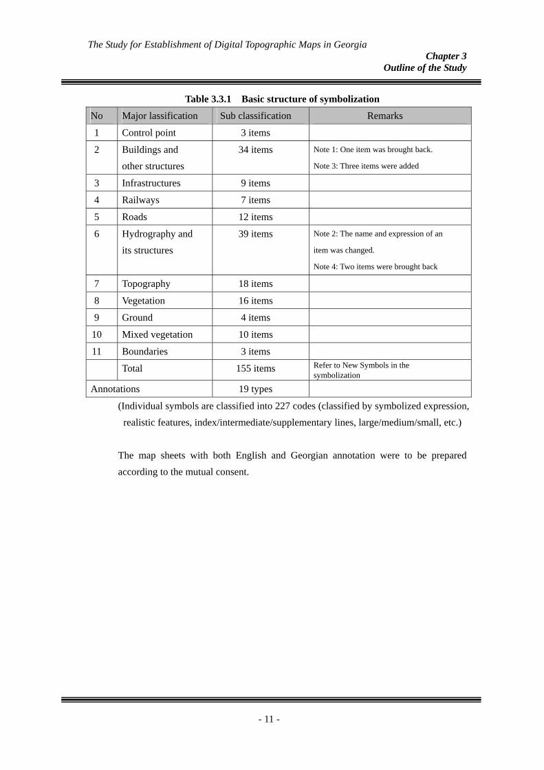
(3) Map symbols Map symbolization was carried out after finishing correction of the final topographic data in accordance with the specification of map symbols that had been prepared previously. This work was done with the use of software “Illustrator” which excels its efficiency in graphic function. The table 3.3.1 outlines the basic structure of symbolization.
- 10 -
The Study for Establishment of Digital Topographic Maps in Georgia Chapter 3
Outline of the Study
Table 3.3.1 Basic structure of symbolization
No Major lassification Sub classification Remarks
1 Control point 3 items
2 Buildings and other structures
34 items Note 1: One item was brought back.
Note 3: Three items were added
3 Infrastructures 9 items
4 Railways 7 items
5 Roads 12 items
6 Hydrography and its structures
39 items Note 2: The name and expression of an
item was changed.
Note 4: Two items were brought back
7 Topography 18 items
8 Vegetation 16 items
9 Ground 4 items
10 Mixed vegetation 10 items
11 Boundaries 3 items
Total 155 items Refer to New Symbols in the symbolization
Annotations 19 types
(Individual symbols are classified into 227 codes (classified by symbolized expression, realistic features, index/intermediate/supplementary lines, large/medium/small, etc.)
The map sheets with both English and Georgian annotation were to be prepared according to the mutual consent.
- 11 -
The Study for Establishment of Digital Topographic Maps in Georgia Chapter 3
Outline of the Study
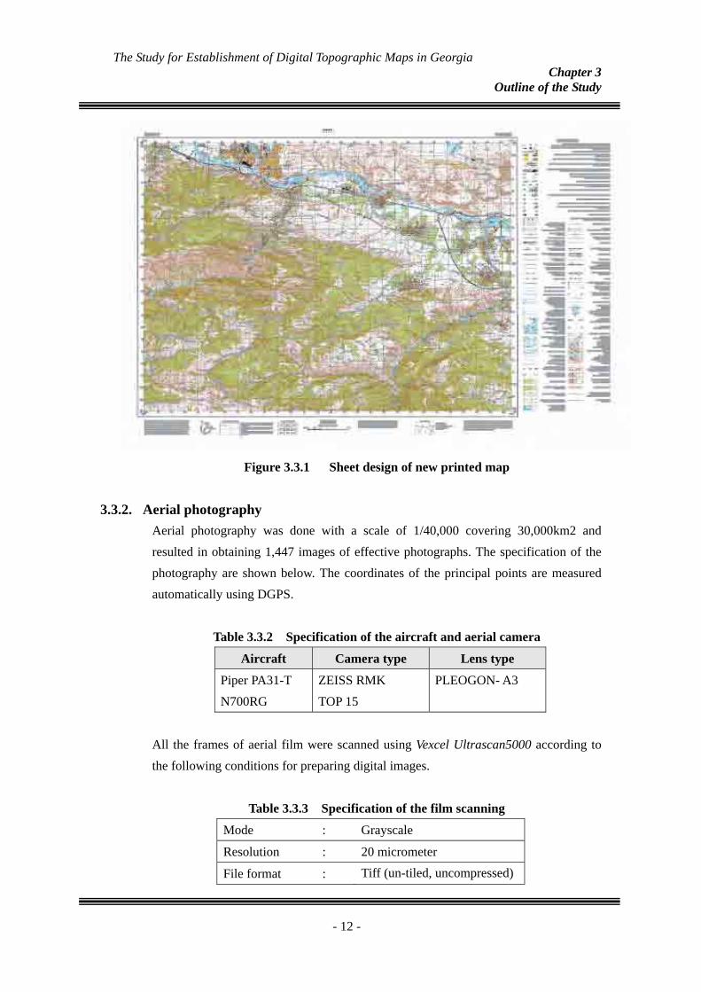
Figure 3.3.1 Sheet design of new printed map
3.3.2. Aerial photography Aerial photography was done with a scale of 1/40,000 covering 30,000km2 and resulted in obtaining 1,447 images of effective photographs. The specification of the photography are shown below. The coordinates of the principal points are measured automatically using DGPS.
Table 3.3.2 Specification of the aircraft and aerial camera
Aircraft Camera type Lens type
Piper PA31-T N700RG
ZEISS RMK TOP 15
PLEOGON- A3
All the frames of aerial film were scanned using Vexcel Ultrascan5000 according to the following conditions for preparing digital images.
Table 3.3.3 Specification of the film scanning
Mode : Grayscale
Resolution : 20 micrometer
File format : Tiff (un-tiled, uncompressed)
- 12 -
The Study for Establishment of Digital Topographic Maps in Georgia Chapter 3
Outline of the Study
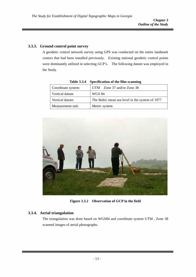
3.3.3. Ground control point survey A geodetic control network survey using GPS was conducted on the entire landmark centers that had been installed previously. Existing national geodetic control points were dominantly utilized in selecting GCP’s. The following datum was employed in the Study.
Table 3.3.4 Specification of the film scanning
Coordinate system: UTM Zone 37 and/or Zone 38
Vertical datum WGS 84
Vertical datum: The Baltic mean sea level in the system of 1977
Measurement unit Metric system
Figure 3.3.2 Observation of GCP in the field
3.3.4. Aerial triangulation The triangulation was done based on WGS84 and coordinate system UTM , Zone 38 scanned images of aerial photographs.
- 13 -
The Study for Establishment of Digital Topographic Maps in Georgia Chapter 3
Outline of the Study
Figure 3.3.3 Allocation of control points in each block
In the horizontal and vertical directions, the resulted standard deviation of residual errors computed as “RMS” and maximum residual errors of the control points are presented in Table 3.3.4 below :
Table 3.3.5 Specification of the film scanning
X (Longitude) Y (Latitude) Z (Elevation) Block No.
Standard
deviation
Max. Standard
deviation
Max. Standard
deviation
Max.
B1 0.237 +0.846 0.213 -0.643 0.088 -0.340
B2 0.358 +1.327 0.293 -0.866 0.047 +0.124
The above adjustment computation results could be deemed as a satisfactory level of accuracy.
Accuracy standards for standard deviation of residual errors X: less than 1.2 m (“altitude above ground level” x 0.02 %) Y: less than 1.2 m (“altitude above ground level” x 0.02 %) Z: less than 1.2 m (“altitude above ground level” x 0.02 %)
Accuracy standards for maximum of residual errors
X: less than 2.4 m (“altitude above ground level” x 0.04 %) Y: less than 2.4 m (“altitude above ground level” x 0.04 %) Z: less than 2.4 m (“altitude above ground level” x 0.04 %)
- 14 -
The Study for Establishment of Digital Topographic Maps in Georgia Chapter 3
Outline of the Study
3.3.5.
(1)
Field Completion
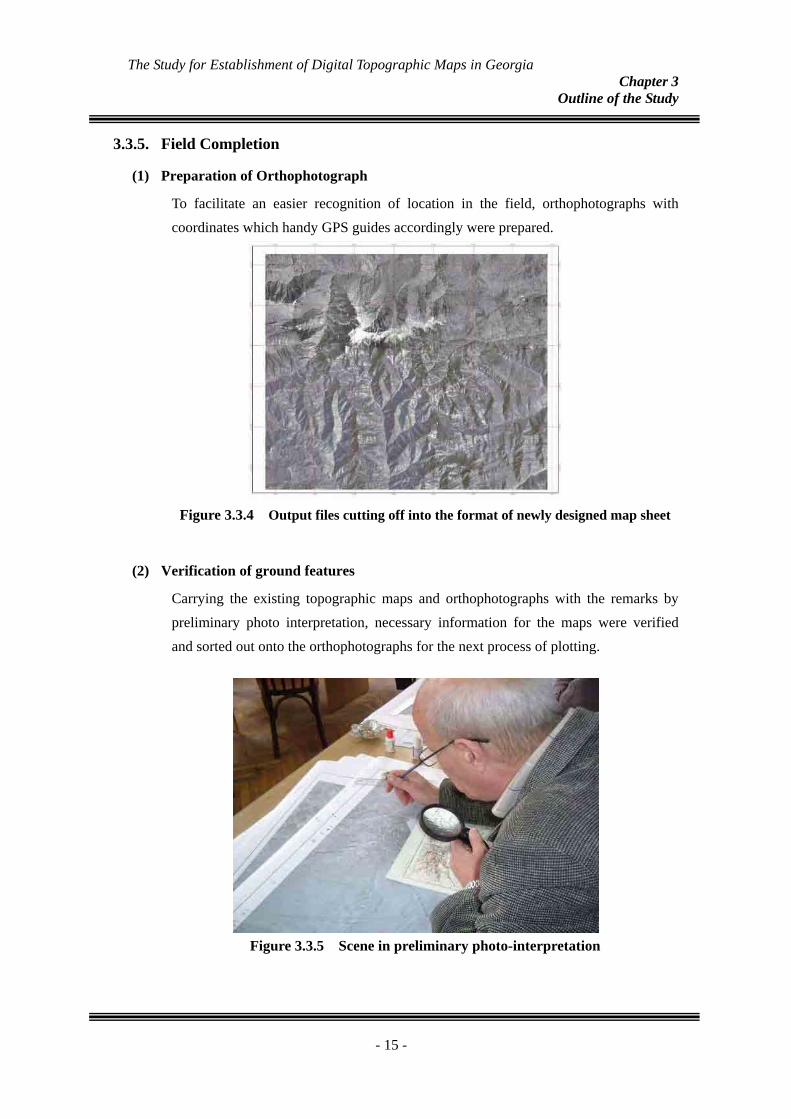
Preparation of Orthophotograph
To facilitate an easier recognition of location in the field, orthophotographs with coordinates which handy GPS guides accordingly were prepared.
Figure 3.3.4 Output files cutting off into the format of newly designed map sheet
(2) Verification of ground features
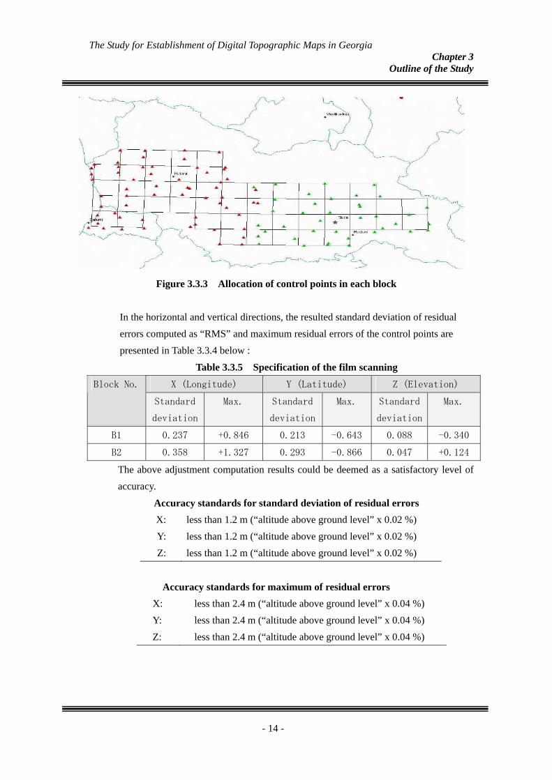
Carrying the existing topographic maps and orthophotographs with the remarks by preliminary photo interpretation, necessary information for the maps were verified and sorted out onto the orthophotographs for the next process of plotting.
Figure 3.3.5 Scene in preliminary photo-interpretation
- 15 -
The Study for Establishment of Digital Topographic Maps in Georgia Chapter 3
Outline of the Study
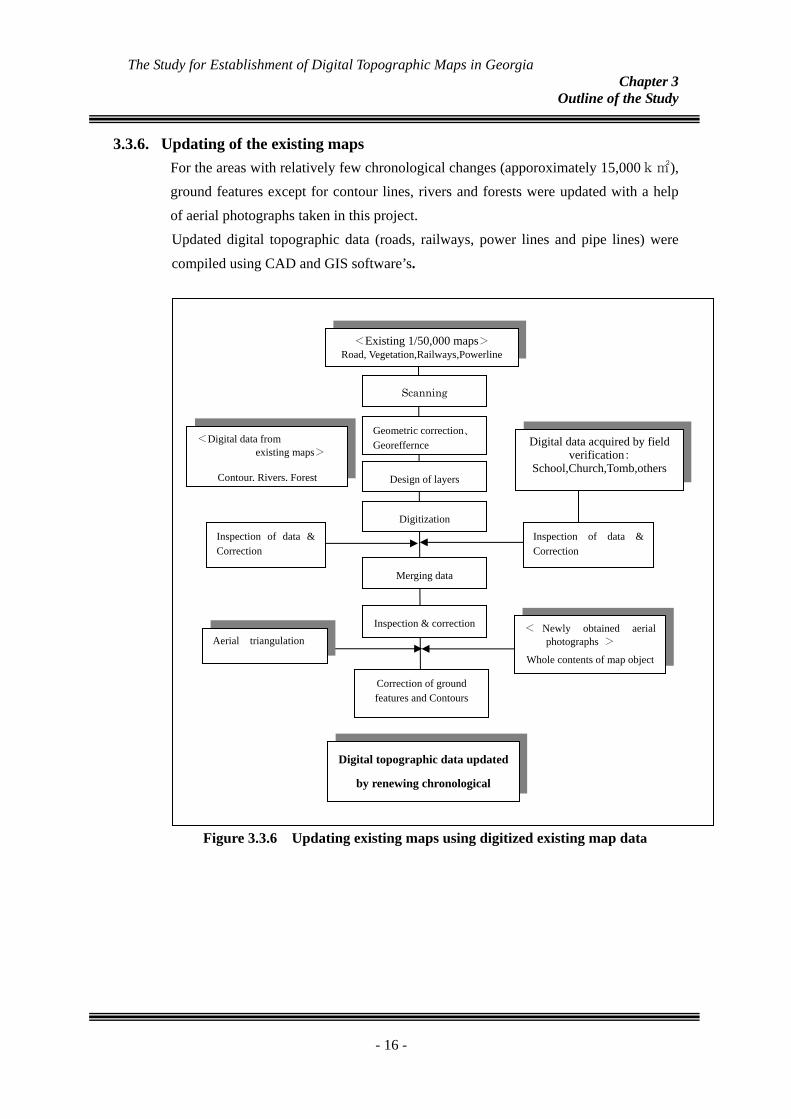
3.3.6. Updating of the existing maps For the areas with relatively few chronological changes (apporoximately 15,000k㎡), ground features except for contour lines, rivers and forests were updated with a help of aerial photographs taken in this project. Updated digital topographic data (roads, railways, power lines and pipe lines) were
compiled using CAD and GIS software’s.
Figure 3.3.6 Updating existing maps using digitized existing map data
<Digital data from existing maps>
Contour, Rivers, Forest
<Existing 1/50,000 maps> Road, Vegetation,Railways,Powerline
Inspection of data & Correction
Digital data acquired by field verification:
School,Church,Tomb,others
Scanning
Geometric correction、 Georeffernce
Digitization
Inspection & correction
Correction of ground features and Contours
< Newly obtained aerial photographs >
Whole contents of map object
Inspection of data & Correction
Merging data
Digital topographic data updated
by renewing chronological
Design of layers
Aerial triangulation
- 16 -
The Study for Establishment of Digital Topographic Maps in Georgia Chapter 3
Outline of the Study
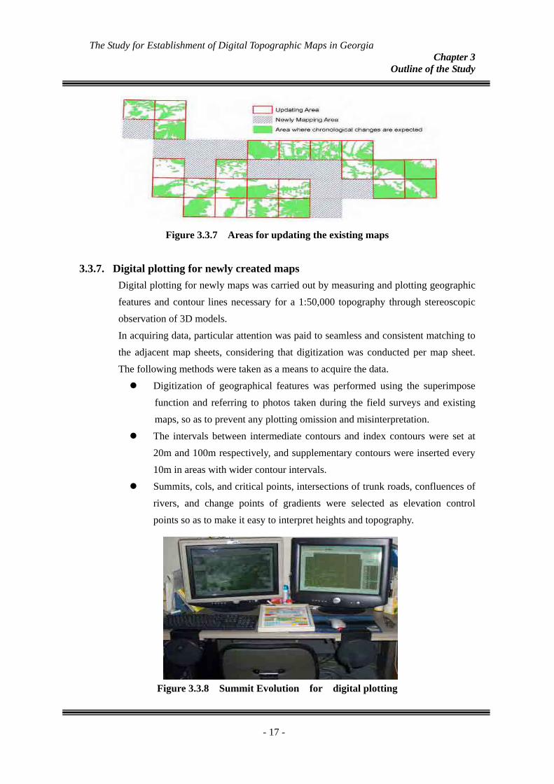
Figure 3.3.7 Areas for updating the existing maps
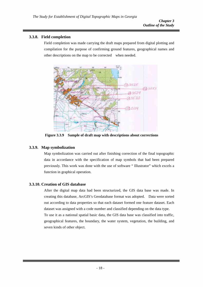
3.3.7. Digital plotting for newly created maps Digital plotting for newly maps was carried out by measuring and plotting geographic features and contour lines necessary for a 1:50,000 topography through stereoscopic observation of 3D models. In acquiring data, particular attention was paid to seamless and consistent matching to the adjacent map sheets, considering that digitization was conducted per map sheet. The following methods were taken as a means to acquire the data.
Digitization of geographical features was performed using the superimpose function and referring to photos taken during the field surveys and existing maps, so as to prevent any plotting omission and misinterpretation.
The intervals between intermediate contours and index contours were set at 20m and 100m respectively, and supplementary contours were inserted every 10m in areas with wider contour intervals.
Summits, cols, and critical points, intersections of trunk roads, confluences of rivers, and change points of gradients were selected as elevation control points so as to make it easy to interpret heights and topography.
Figure 3.3.8 Summit Evolution for digital plotting
- 17 -
The Study for Establishment of Digital Topographic Maps in Georgia Chapter 3
Outline of the Study
3.3.8. Field completion Field completion was made carrying the draft maps prepared from digital plotting and compilation for the purpose of confirming ground features, geographical names and other descriptions on the map to be corrected when needed.
Figure 3.3.9 Sample of draft map with descriptions about corrections
3.3.9.
3.3.10.
Map symbolization Map symbolization was carried out after finishing correction of the final topographic data in accordance with the specification of map symbols that had been prepared previously. This work was done with the use of software “ Illustrator” which excels a function in graphical operation.
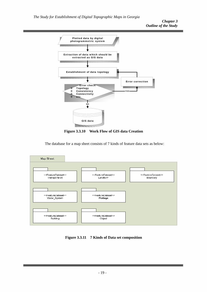
Creation of GIS database After the digital map data had been structurized, the GIS data base was made. In creating this database, ArcGIS’s Geodatabase format was adopted. Data were sorted out according to data properties so that each dataset formed one feature dataset. Each dataset was assigned with a code number and classified depending on the data type. To use it as a national spatial basic data, the GIS data base was classified into traffic, geographical features, the boundary, the water system, vegetation, the building, and seven kinds of other object.
- 18 -
The Study for Establishment of Digital Topographic Maps in Georgia Chapter 3
Outline of the Study
Plotted data by digitalphotogrammetric system
Extraction of data which should beextracted as GIS data
Establishment of data topology
Error correctionError check
TopologyConsistencyConnectivityetc
YES
GIS data
NO
Figure 3.3.10 Work Flow of GIS data Creation
The database for a map sheet consists of 7 kinds of feature data sets as below:
Figure 3.3.11 7 Kinds of Data set composition
- 19 -
The Study for Establishment of Digital Topographic Maps in Georgia Chapter 3
Outline of the Study
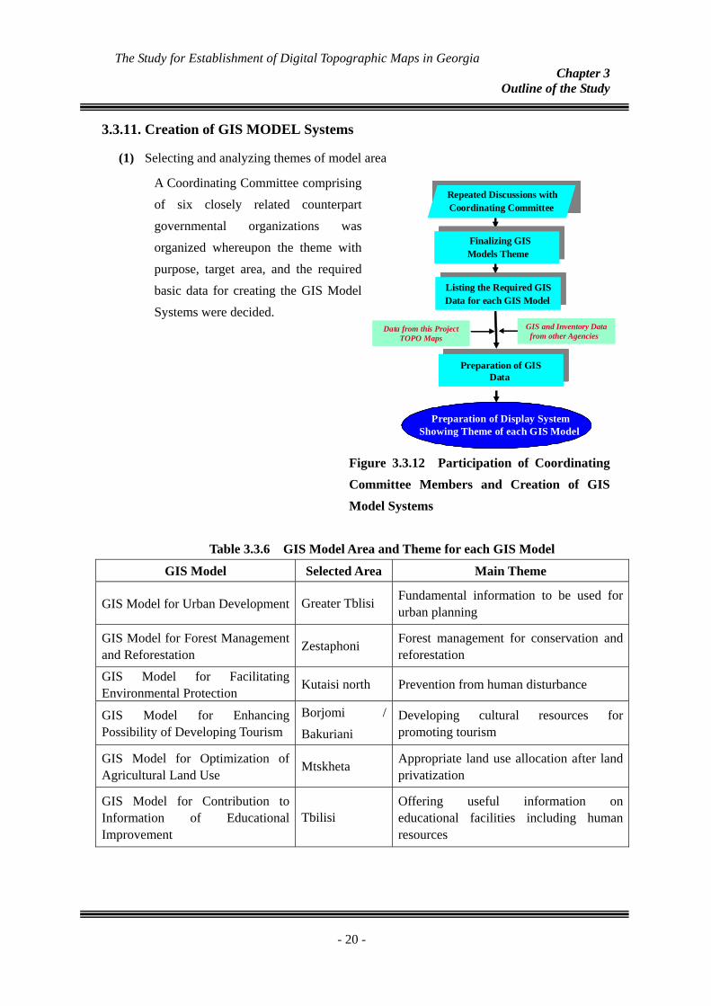
3.3.11.
(1)
Creation of GIS MODEL Systems
Selecting and analyzing themes of model area
A Coordinating Committee comprising of six closely related counterpart governmental organizations was organized whereupon the theme with purpose, target area, and the required basic data for creating the GIS Model Systems were decided.
Figure 3.3.12 Participation of Coordinating Committee Members and Creation of GIS Model Systems
Table 3.3.6 GIS Model Area and Theme for each GIS Model
Repeated Discussions withCoordinating Committee
Listing the Required GIS Data for each GIS Model
Preparation of Display System Showing Theme of each GIS Model
GIS and Inventory Data from other Agencies
Data from this Project TOPO Maps
Finalizing GIS Models Theme
Preparation of GIS Data
Repeated Discussions withCoordinating Committee
Listing the Required GIS Data for each GIS Model
Preparation of Display System Showing Theme of each GIS Model
Preparation of Display System Showing Theme of each GIS Model
GIS and Inventory Data from other Agencies
Data from this Project TOPO Maps
Finalizing GIS Models Theme
Preparation of GIS Data
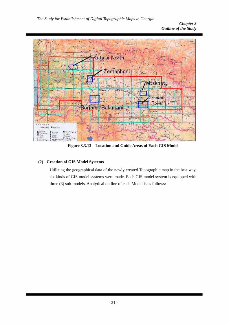
GIS Model Selected Area Main Theme
GIS Model for Urban Development Greater Tblisi Fundamental information to be used for urban planning
GIS Model for Forest Management and Reforestation
Zestaphoni Forest management for conservation and reforestation
GIS Model for Facilitating Environmental Protection
Kutaisi north Prevention from human disturbance
GIS Model for Enhancing Possibility of Developing Tourism
Borjomi / Bakuriani
Developing cultural resources for promoting tourism
GIS Model for Optimization of Agricultural Land Use
Mtskheta Appropriate land use allocation after land privatization
GIS Model for Contribution to Information of Educational Improvement
Tbilisi Offering useful information on educational facilities including human resources
- 20 -
The Study for Establishment of Digital Topographic Maps in Georgia Chapter 3
Outline of the Study
Figure 3.3.13 Location and Guide Areas of Each GIS Model
(2) Creation of GIS Model Systems
the newly created Topographic map in the best way, Utilizing the geographical data ofsix kinds of GIS model systems were made. Each GIS model system is equipped with three (3) sub-models. Analytical outline of each Model is as follows:
- 21 -
The Study for Establishment of Digital Topographic Maps in Georgia Chapter 3
Outline of the Study
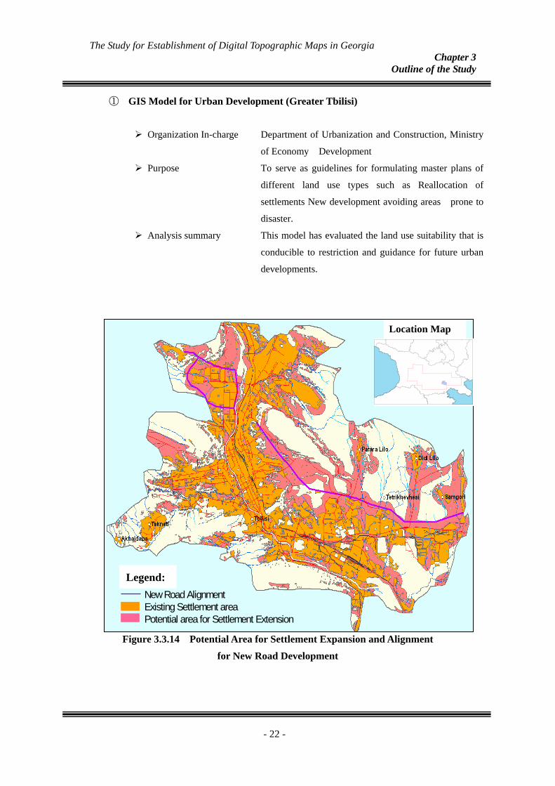
① GIS Model for Urban Development (Greater Tbilisi)
Organization In-charge Department of Urbanization and Construction, Ministry
of Economy Development
Purpose To serve as guidelines for formulating master plans of
different land use types such as Reallocation of
settlements New development avoiding areas prone to
disaster.
Analysis summary This model has evaluated the land use suitability that is
conducible to restriction and guidance for future urban
developments.
New Road AlignmentExisting Settlement areaPotential area for Settlement Extension
Location Map
E
Legend:
Figure 3.3.14 Potential Area for Settlement Expansion and Alignment for New Road Development
- 22 -
The Study for Establishment of Digital Topographic Maps in Georgia Chapter 3
Outline of the Study
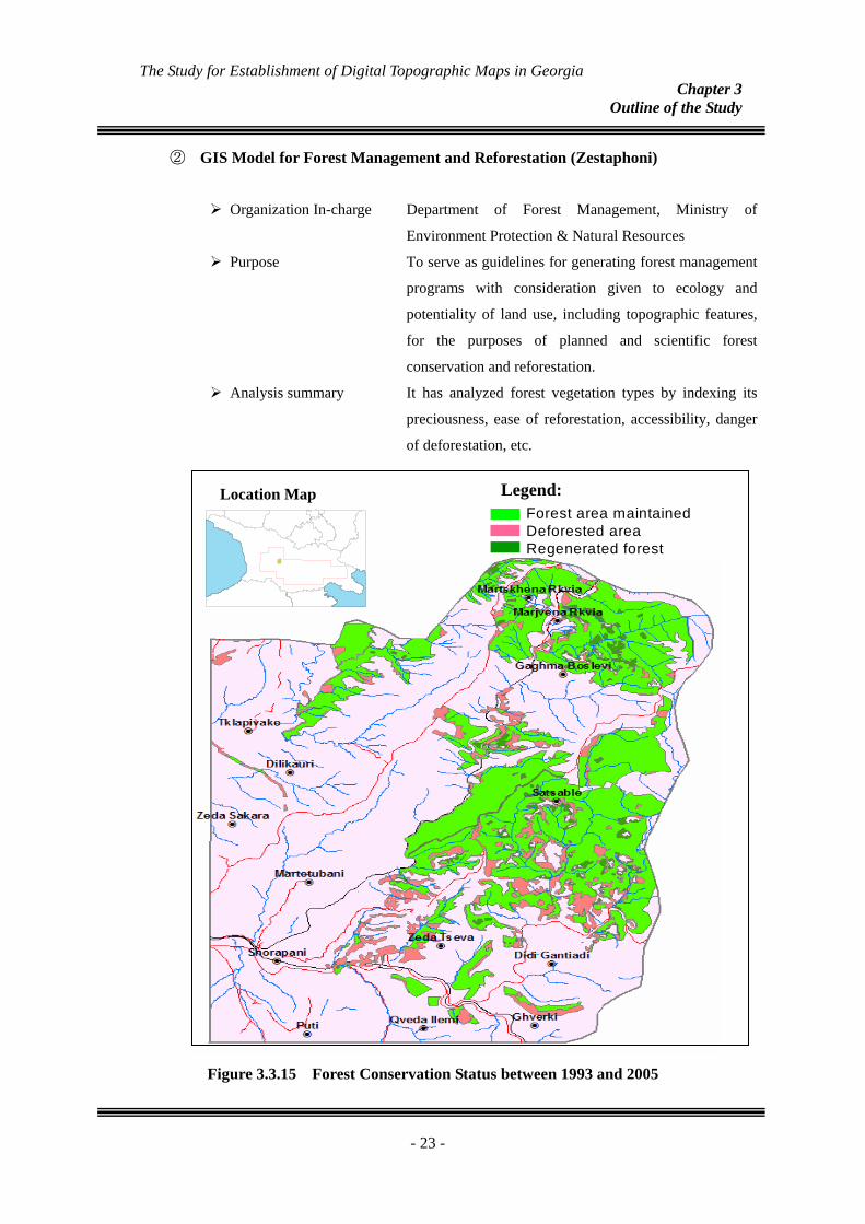
② GIS Model for Forest Management and Reforestation (Zestaphoni)
Organization In-charge Department of Forest Management, Ministry of
Environment Protection & Natural Resources
Purpose To serve as guidelines for generating forest management
programs with consideration given to ecology and
potentiality of land use, including topographic features,
for the purposes of planned and scientific forest
conservation and reforestation.
Analysis summary It has analyzed forest vegetation types by indexing its
preciousness, ease of reforestation, accessibility, danger
of deforestation, etc.
Legend:
Forest area maintained Deforested areaRegenerated forest
Location Map
E
Figure 3.3.15 Forest Conservation Status between 1993 and 2005
- 23 -
The Study for Establishment of Digital Topographic Maps in Georgia Chapter 3
Outline of the Study
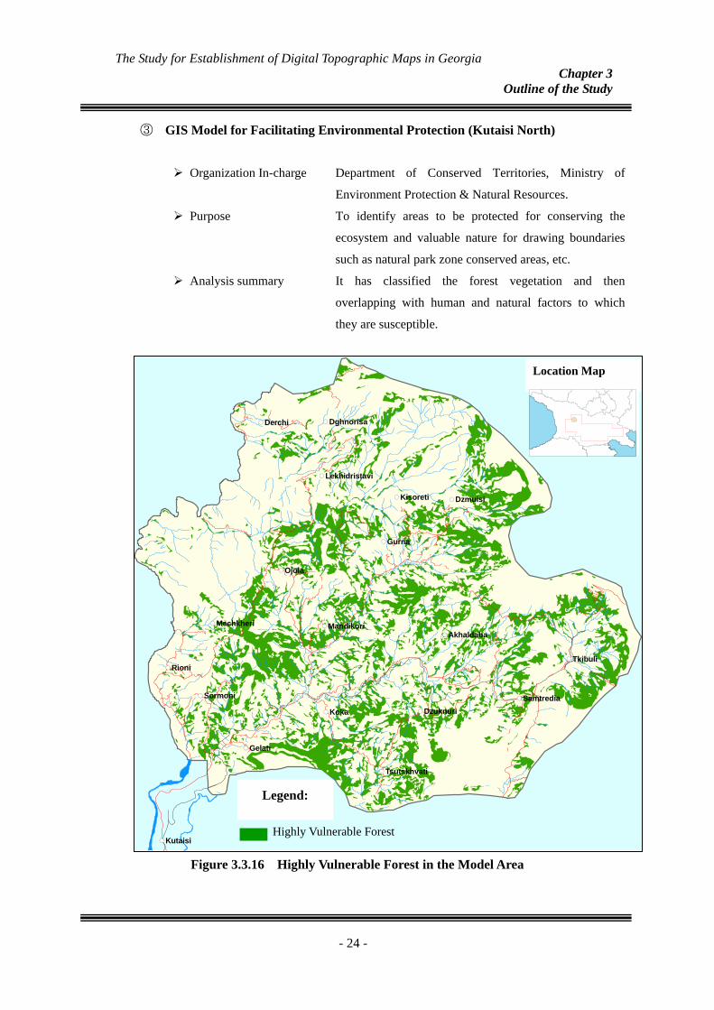
③ GIS Model for Facilitating Environmental Protection (Kutaisi North)
Organization In-charge Department of Conserved Territories, Ministry of
Environment Protection & Natural Resources.
Purpose To identify areas to be protected for conserving the
ecosystem and valuable nature for drawing boundaries
such as natural park zone conserved areas, etc.
Analysis summary It has classified the forest vegetation and then
overlapping with human and natural factors to which
they are susceptible.
Figure 3.3.16 Highly Vulnerable Forest in the Model Area
- 24 -
!(
!(
!(
!(
!(
!(
!(
!(
!(
!(
!(
!(
!(
!(
!(
!(
!(
!(
!(
Koka
Rioni
Ojola
Gurna
Derchi
Gelati
Kutaisi
Sormoni
Dzmuisi
Tkibuli
Dzuknuri
Kisoreti
Mechkheri
Dghnorisa
Akhaldaba
Samtredia
Mandikori
Tsutskhvati
Lekhidristavi
Highly Vulnerable Forest
Legend:
Location Map
E
The Study for Establishment of Digital Topographic Maps in Georgia Chapter 3
Outline of the Study
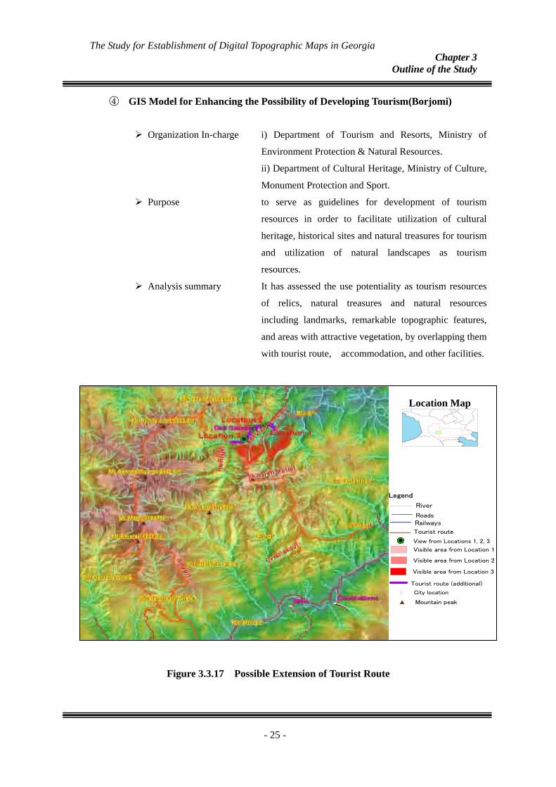
④ GIS Model for Enhancing the Possibility of Developing Tourism(Borjomi)
Organization In-charge i) Department of Tourism and Resorts, Ministry of
Environment Protection & Natural Resources.
ii) Department of Cultural Heritage, Ministry of Culture,
Monument Protection and Sport.
Purpose to serve as guidelines for development of tourism
resources in order to facilitate utilization of cultural
heritage, historical sites and natural treasures for tourism
and utilization of natural landscapes as tourism
resources.
Analysis summary It has assessed the use potentiality as tourism resources
of relics, natural treasures and natural resources
including landmarks, remarkable topographic features,
and areas with attractive vegetation, by overlapping them
with tourist route, accommodation, and other facilities.
Location Map
E
Legend
RailwaysRoads
River
Tourist route
!P View from Locations 1, 2, 3
Visible area from Location 1
Visible area from Location 2
Visible area from Location 3
Tourist route (additional)
#* Mountain peak
!( City location
Figure 3.3.17 Possible Extension of Tourist Route
- 25 -
The Study for Establishment of Digital Topographic Maps in Georgia Chapter 3
Outline of the Study
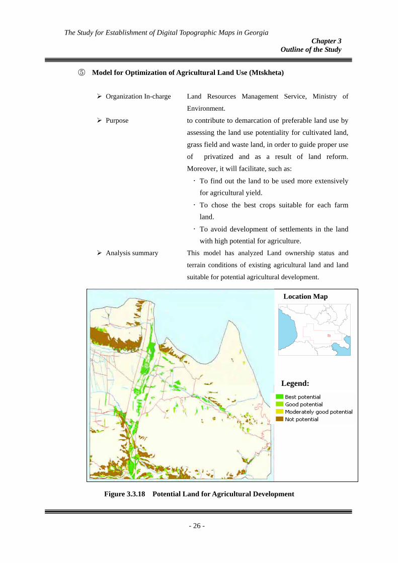
⑤ Model for Optimization of Agricultural Land Use (Mtskheta)
Organization In-charge Land Resources Management Service, Ministry of
Environment.
Purpose to contribute to demarcation of preferable land use by assessing the land use potentiality for cultivated land, grass field and waste land, in order to guide proper use of privatized and as a result of land reform. Moreover, it will facilitate, such as:
• To find out the land to be used more extensively for agricultural yield.
• To chose the best crops suitable for each farm land.
• To avoid development of settlements in the land with high potential for agriculture.
Analysis summary This model has analyzed Land ownership status and
terrain conditions of existing agricultural land and land
suitable for potential agricultural development.
Location Map
E
Legend:
Figure 3.3.18 Potential Land for Agricultural Development
- 26 -
The Study for Establishment of Digital Topographic Maps in Georgia Chapter 3
Outline of the Study
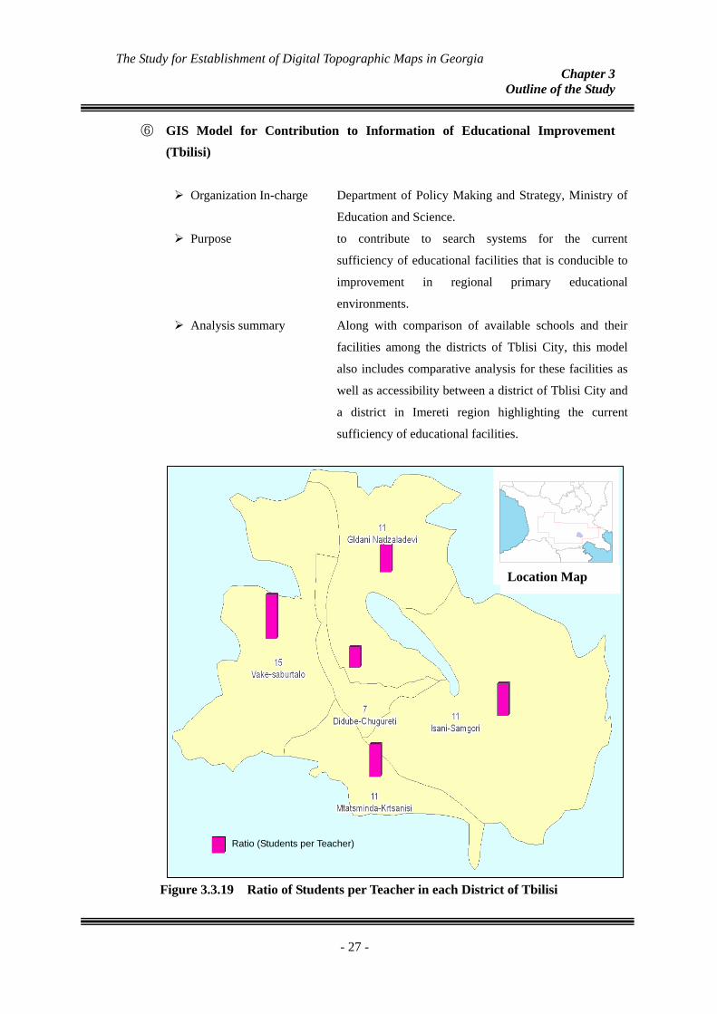
⑥ GIS Model for Contribution to Information of Educational Improvement (Tbilisi)
Organization In-charge Department of Policy Making and Strategy, Ministry of
Education and Science.
Purpose to contribute to search systems for the current
sufficiency of educational facilities that is conducible to
improvement in regional primary educational
environments.
Analysis summary Along with comparison of available schools and their
facilities among the districts of Tblisi City, this model
also includes comparative analysis for these facilities as
well as accessibility between a district of Tblisi City and
a district in Imereti region highlighting the current
sufficiency of educational facilities.
Ratio (Students per Teacher)
Location Map
E
Figure 3.3.19 Ratio of Students per Teacher in each District of Tbilisi
- 27 -
The Study for Establishment of Digital Topographic Maps in Georgia Chapter 3
Outline of the Study
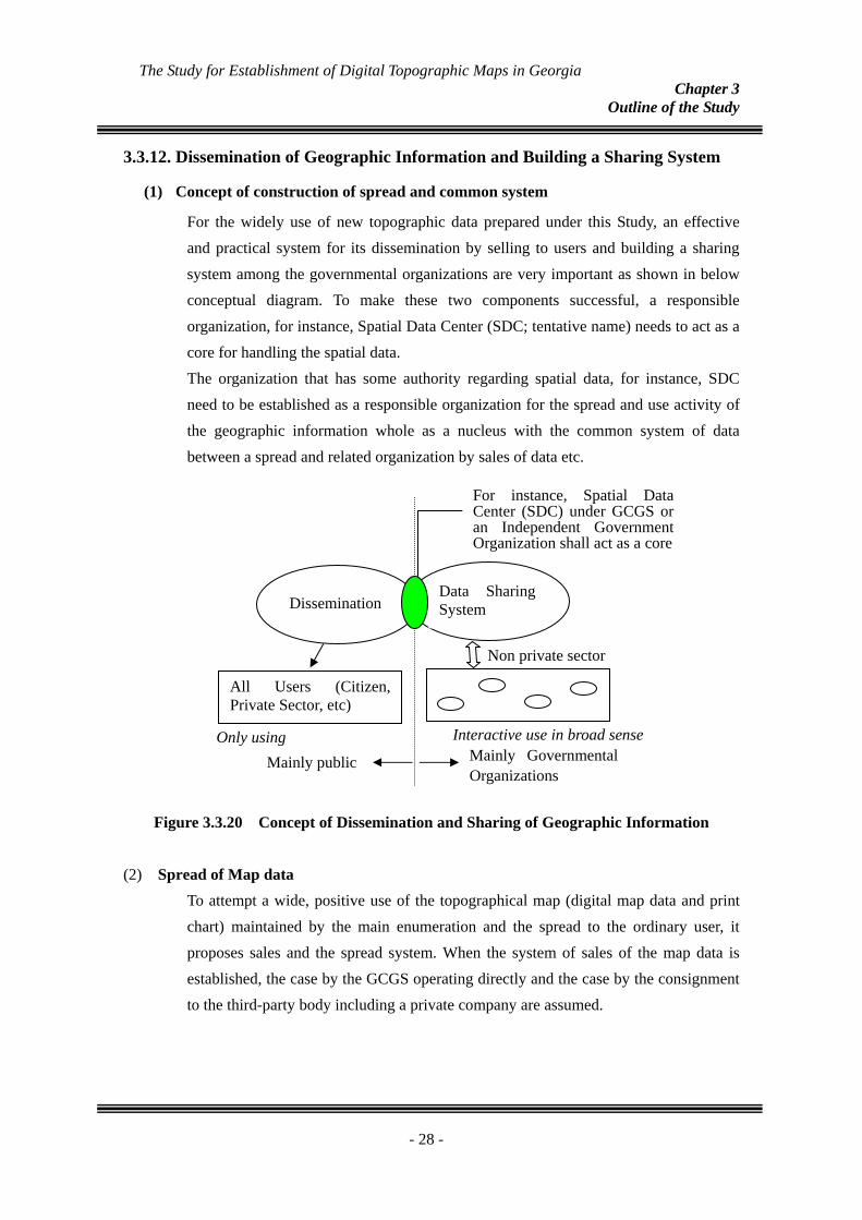
3.3.12.
(1)
Dissemination of Geographic Information and Building a Sharing System
Concept of construction of spread and common system
For the widely use of new topographic data prepared under this Study, an effective and practical system for its dissemination by selling to users and building a sharing system among the governmental organizations are very important as shown in below conceptual diagram. To make these two components successful, a responsible organization, for instance, Spatial Data Center (SDC; tentative name) needs to act as a core for handling the spatial data. The organization that has some authority regarding spatial data, for instance, SDC need to be established as a responsible organization for the spread and use activity of the geographic information whole as a nucleus with the common system of data between a spread and related organization by sales of data etc.
Non private sector
Mainly Governmental Organizations
Mainly public
Interactive use in broad sense Only using
Dissemination Data Sharing System
All Users (Citizen, Private Sector, etc)
For instance, Spatial Data Center (SDC) under GCGS or an Independent Government Organization shall act as a core
Figure 3.3.20 Concept of Dissemination and Sharing of Geographic Information
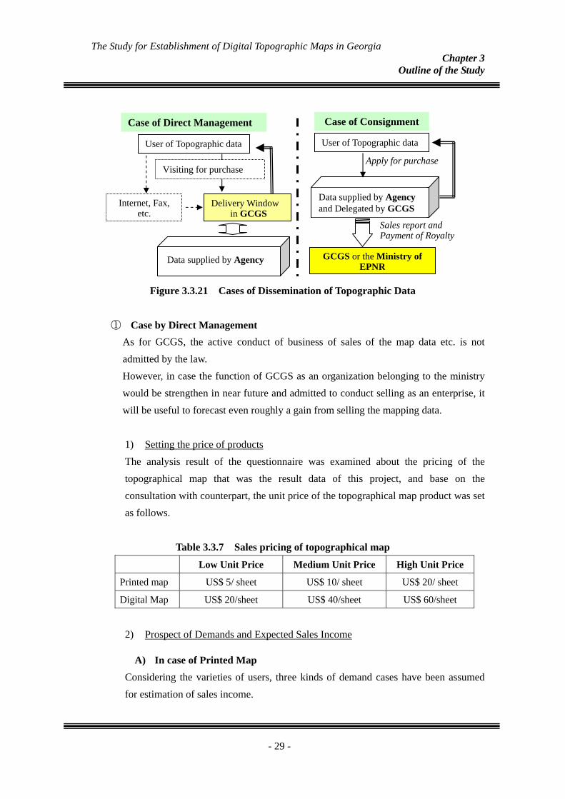
(2) Spread of Map data To attempt a wide, positive use of the topographical map (digital map data and print chart) maintained by the main enumeration and the spread to the ordinary user, it proposes sales and the spread system. When the system of sales of the map data is established, the case by the GCGS operating directly and the case by the consignment to the third-party body including a private company are assumed.
- 28 -
The Study for Establishment of Digital Topographic Maps in Georgia Chapter 3
Outline of the Study
Sales report and Payment of Royalty
Apply for purchase
User of Topographic data
GCGS or the Ministry of EPNR
Data supplied by Agency and Delegated by GCGS
Case of Consignment
User of Topographic data
Internet, Fax, etc.
Delivery Window in GCGS
Visiting for purchase
Data supplied by Agency
Case of Direct Management
Figure 3.3.21 Cases of Dissemination of Topographic Data
① Case by Direct Management As for GCGS, the active conduct of business of sales of the map data etc. is not admitted by the law. However, in case the function of GCGS as an organization belonging to the ministry would be strengthen in near future and admitted to conduct selling as an enterprise, it will be useful to forecast even roughly a gain from selling the mapping data.
1) Setting the price of products The analysis result of the questionnaire was examined about the pricing of the topographical map that was the result data of this project, and base on the consultation with counterpart, the unit price of the topographical map product was set as follows.
Table 3.3.7 Sales pricing of topographical map
Low Unit Price Medium Unit Price High Unit Price
Printed map US$ 5/ sheet US$ 10/ sheet US$ 20/ sheet
Digital Map US$ 20/sheet US$ 40/sheet US$ 60/sheet
2) Prospect of Demands and Expected Sales Income
A) In case of Printed Map Considering the varieties of users, three kinds of demand cases have been assumed for estimation of sales income.
- 29 -
The Study for Establishment of Digital Topographic Maps in Georgia Chapter 3
Outline of the Study
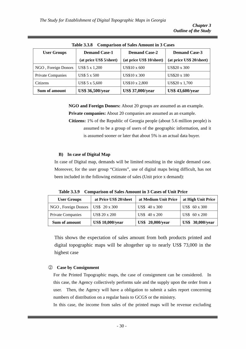
Table 3.3.8 Comparison of Sales Amount in 3 Cases
User Groups Demand Case-1
(at price US$ 5/sheet)
Demand Case-2
(at price US$ 10/sheet)
Demand Case-3
(at price US$ 20/sheet)
NGO , Foreign Donors US$ 5 x 1,200 US$10 x 600 US$20 x 300
Private Companies US$ 5 x 500 US$10 x 300 US$20 x 180
Citizens US$ 5 x 5,600 US$10 x 2,800 US$20 x 1,700
Sum of amount US$ 36,500/year US$ 37,000/year US$ 43,600/year
NGO and Foreign Donors: About 20 groups are assumed as an example. Private companies: About 20 companies are assumed as an example. Citizens: 1% of the Republic of Georgia people (about 5.6 million people) is
assumed to be a group of users of the geographic information, and it is assumed sooner or later that about 5% is an actual data buyer.
B) In case of Digital Map In case of Digital map, demands will be limited resulting in the single demand case. Moreover, for the user group “Citizens”, use of digital maps being difficult, has not been included in the following estimate of sales (Unit price x demand):
Table 3.3.9 Comparison of Sales Amount in 3 Cases of Unit Price
User Groups at Price US$ 20/sheet at Medium Unit Price at High Unit Price
NGO , Foreign Donors US$ 20 x 300 US$ 40 x 300 US$ 60 x 300
Private Companies US$ 20 x 200 US$ 40 x 200 US$ 60 x 200
Sum of amount US$ 10,000/year US$ 20,000/year US$ 30,000/year
This shows the expectation of sales amount from both products printed and digital topographic maps will be altogether up to nearly US$ 73,000 in the highest case
② Case by Consignment For the Printed Topographic maps, the case of consignment can be considered. In this case, the Agency collectively performs sale and the supply upon the order from a user. Then, the Agency will have a obligation to submit a sales report concerning numbers of distribution on a regular basis to GCGS or the ministry. In this case, the income from sales of the printed maps will be revenue excluding
- 30 -
The Study for Establishment of Digital Topographic Maps in Georgia Chapter 3
Outline of the Study
costs that comprise of a royalty and maintenance fee to GCGS. The royalty will amount 10 % of total income from the product sales, for instance and 15 to 25 % might be charged for the maintenance of data. Therefore, GCGS or the ministry will be recipient body having income of 25 –35% based on this assumption. Thus, the following revenue as indirect sales of the printed maps will be expected roughly.
Demand Case-1
US$36,500×25%‐30%=US$ 9,125 to 10,950 /year(Maximum Revenue)
Demand Case-2
US$37,000×25%-30%=US$9,250 to 11,100 /year (Minimum Revenue)
Demand Case-3
US$43,600×25%-30%=US$10,900 to 13,080 /year (Medium Revenue)
This means that in Demand Case - 3, when the revenue will be Maximum from a kind of copyright, it will cover the wages for nearly 2.7 staff by setting US$ 400/month/peroson as a salary.
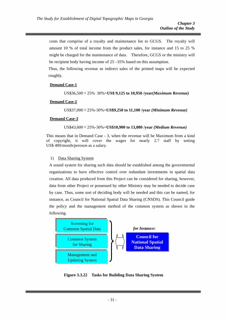
1) Data Sharing System A sound system for sharing such data should be established among the governmental organizations to have effective control over redundant investments in spatial data creation. All data produced from this Project can be considered for sharing, however, data from other Project or possessed by other Ministry may be needed to decide case by case. Thus, some sort of deciding body will be needed and this can be named, for instance, as Council for National Spatial Data Sharing (CNSDS). This Council guide the policy and the management method of the common system as shown in the following.
for Instance:Screening for
Common Spatial Data
Common System for Sharing
Council for National Spatial
Data Sharing Management and Updating System
Figure 3.3.22 Tasks for Building Data Sharing System
- 31 -
The Study for Establishment of Digital Topographic Maps in Georgia Chapter 3
Outline of the Study
地理情報
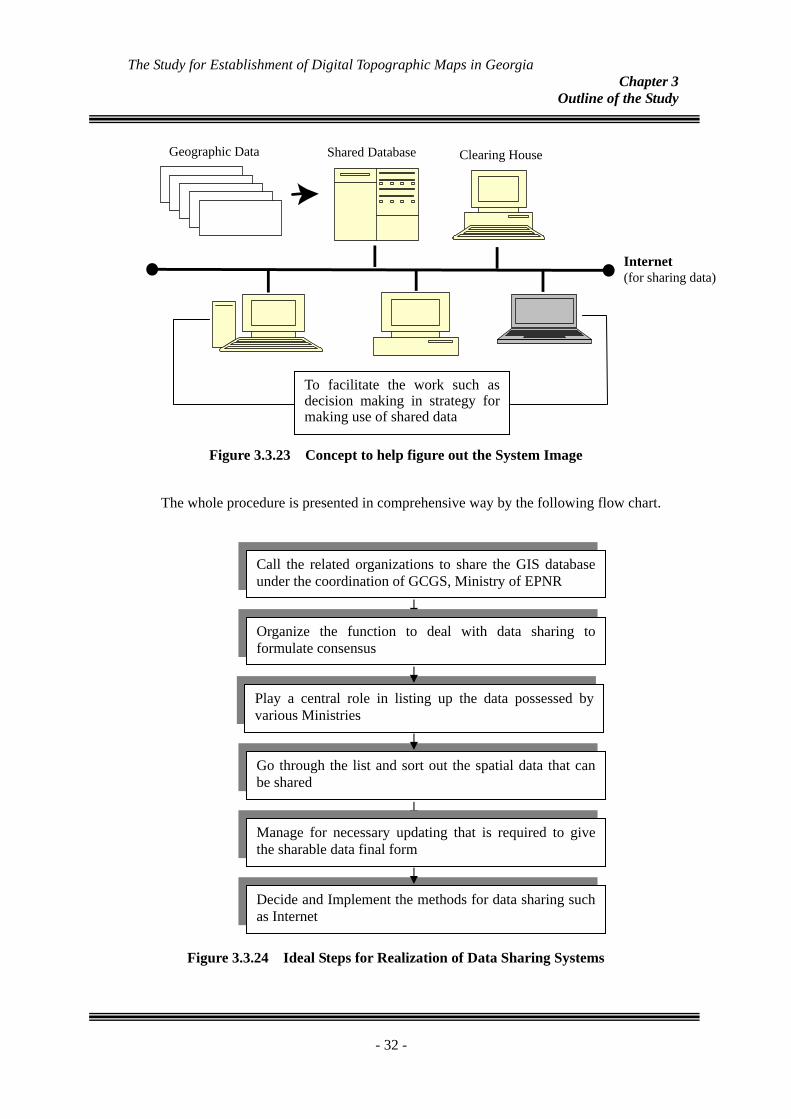
To facilitate the work such as decision making in strategy for making use of shared data
Geographic Data
インターネット(情報公開)Internet (for sharing data)
クリアリングハウス共用データベースShared Database Clearing House
Figure 3.3.23 Concept to help figure out the System Image
The whole procedure is presented in comprehensive way by the following flow chart.
Call the related organizations to share the GIS database under the coordination of GCGS, Ministry of EPNR
Play a central role in listing up the data possessed by various Ministries
Go through the list and sort out the spatial data that can be shared
Decide and Implement the methods for data sharing such as Internet
Manage for necessary updating that is required to give the sharable data final form
Organize the function to deal with data sharing to formulate consensus
Figure 3.3.24 Ideal Steps for Realization of Data Sharing Systems
- 32 -
The Study for Establishment of Digital Topographic Maps in Georgia Chapter 3
Outline of the Study
3.3.13. Workshop With the purpose to demonstrate the understanding of the involved counterpart personnel, the Workshop was organized on 14th February 2008 prior to holding the Seminar. During this, not only the staff of GCGS and Agency got chance to present their knowledge gained during this Project period, but also the members of Task force presented their experience from this Project. All these staffs were being involved in OJTs, in other words their presentation showed the confirmation of knowledge gained during these OJTs. The program of this Workshop was as mentioned in Table 6.4.1.
Table 3.3.10 Program of Workshop
- 33 -
Time Description Title
10:30-10:40 Opening Speech First Deputy Minister Vice Minister of the Ministry ofEnvironment Protection and NaturalResources
10:40-11:00 Project Overview Mr. Hisashi Mori Team leader of the JICA Study Team
Short Introduction for Preparation ofTopographic Map Mr. Akihiro Sugita Member of the JICA Study Team
Ms. Tamar OnashviliMr. Otar Demetrashvili
Vectorization Ms. Khatuna Alasania GCGSMr. Irakali GotsadzeMr. Giorgi PeradzeMr. Shalva RukhadzeMr. Tedo Gorgodze
12:30-12:45 Question and Discussion
GIS Database Creation Ms. Mariam Gigauri SIA14:00-15:00 GIS Application 1 Ms. Nino Khidirbegishvili GCGS
GIS Application 2 Ms. Maka Devidze SIA15:00-15:10 Question and Discussion
Purpose of GIS Model Systems andExpectations Mr. Awadh Kishor Sah Member of the JICA Study Team
Possible use of GIS Model ForestManagement and Reforestation Mr. George Bagaturia Department of Forest Management
15:30-16:20 Possible use of GIS Model for FacilitatingEnvironmental Protection Ms. Lika Salia Department of Protected Areas
Possible use of GIS Model for Enhancing theTourism Development Mr. Kakhaber Todua Department of Tourism and Resorts
Possible use of GIS Model for Optimization ofAgricultural Land Use Mr. Beso Gelitashvili Land Management Service
Possible use of GIS Model for Developingcultural resources in need for tourismpromotion
Mr. Tengiz Kodua Department of Cultural Heritage
16:20-16:30 Question and Discussion16:30 Closing Speech Mr. Irakli Lejava Head of GCGS
Lunch break (12:45 - 14:00)
Coffee break (15:10 - 15:30)
Coffee break (11:00 - 11:15)
Symbolization GCGS / SIA
Creation of Digital Topographic Data GCGS / SIA
11:15-12:30 Field Verification SIA

The Study for Establishment of Digital Topographic Maps in Georgia Chapter 3
Outline of the Study
3.3.14. Seminar Beside the workshop the seminar was successfully held with more than 70 participants
from various organizations. This was attempted for rising keen public awareness of the
effective uses of digital topographic data under the aims of the followings;
Explanation of this research service Explanation of results Explanation of digital technique used by main enumeration Introduction of uses of made digital topographical map and GIS basic data, etc. Construction vision of system concerning use and spread of geographic
information
Therefore, main emphasis was placed on utilization of the digital data for its applications
to such as GIS analysis.
5 specialist from the members of coordinating committee were involved in making their
presentations for this purpose.
Table 3.3.11 Program of the Seminar Time Title Speaker Affiliation
9:30-9:40 Opening Address Mr. Zaal Gamtsemlidze
Minister of the Ministry of Environment Protection and Natural Resources
9:40- 9:50 Acknowledgement Mr. Mitsuhiro Kohno First Secretary, The Embassy of Japan in Azerbaijan
9:50-10:20 Project Overview and Outputs Mr. Hisashi Mori Team leader of the JICA Study Team
Coffee break (10:20 - 10:40) Part-1: Presentation of the Results of the Study
10:40-10:55 Preparation of Topographic Maps Mr. Akihiro Sugita Member of the JICA Study Team
10:55-11:10 Creation of GIS database Mr. Akihiro Sugita Ditto
11:10-11:30 Skills learned through the technology transfer Ms. Maka Devidze Ms. Tamar Onashvili
GCGS / SIA
11:30-11:50 GIS Model Systems for demonstrating the effective use of digital topographic data
Mr. Awadh Kishor Sah Member of the JICA Study Team
11:50-12:00 Question and Answer Lunch break (12:00 - 13:30)
Part-2 Application and Recommendations on Dissemination of Spatial Data
13:30-13:45 Promising uses of digital topographic data with the use of GIS Model Systems
Mr. Awadh Kishor Sah Member of the JICA Study Team
13:45-14:00 Appraisal of effectiveness in practical use of the Mr. Tengiz Kodua Department of Cultural
- 34 -
The Study for Establishment of Digital Topographic Maps in Georgia Chapter 3
Outline of the Study
GIS Model System - Useful information to approach the designation of cultural tourism
Heritage, Ministry of Culture, Monument Protection and Sports
14:00-14:10 Appraisal of effectiveness in practical use of the GIS Model System - Useful information to develop natural resources for promoting tourism
Mr. Kakhaber Todua Department. of Tourism and Resorts, Ministry of Economic Development
14:10-14:20 Appraisal of effectiveness in practical use of the GIS Model System - Possibilities to contribute to demarcation of Protected Area
Ms. Lika Salia
Department of Protected Areas, Ministry of Environment Protection and Natural Resources
14:30-14:40 Appraisal of effectiveness in practical use of the GIS Model System - Possibilities to contribute to allocating agricultural lands
Mr. Beso Gelitashvili
Land Management Service, Ministry of Environment Protection and Natural Resources
14:40-14:50 Appraisal of effectiveness in practical use of the GIS Model System - Possibilities to contribute to planning reforestation
Mr. George Bagaturia
Department of Forest Management, Ministry of Environment Protection and Natural Resources
Coffee break (14:50 - 15:10)
15:10-15:25 Some Useful Suggestions for Dissemination of Spatial Data
Mr. Hisashi Mori Team leader of the JICA Study Team
15:25-15:30 Vision of GCGS in Promoting Spatial Data Mr. Irakli Lejava
Head of GCGS, Ministry of Environment Protection and Natural Resources
15:30-15:40 Question and Discussion 15:40 Closing Remarks Mr. Michio Kanda Special Advisor, JICA
Figure 3.3.25 Presentation by the Study Team
Figure 3.3.26 Participants attended the Seminar
- 35 -
The Study for Establishment of Digital Topographic Maps in Georgia Chapter 3
Outline of the Study
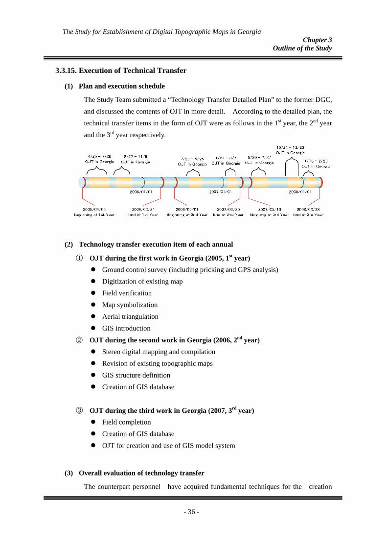
3.3.15.
(1)
Execution of Technical Transfer
Plan and execution schedule
The Study Team submitted a “Technology Transfer Detailed Plan” to the former DGC, and discussed the contents of OJT in more detail. According to the detailed plan, the technical transfer items in the form of OJT were as follows in the 1st year, the 2nd year and the 3rd year respectively.
(2)
(3)
Technology transfer execution item of each annual
① OJT during the first work in Georgia (2005, 1st year) Ground control survey (including pricking and GPS analysis) Digitization of existing map Field verification Map symbolization Aerial triangulation GIS introduction
② OJT during the second work in Georgia (2006, 2nd year)
Stereo digital mapping and compilation Revision of existing topographic maps GIS structure definition Creation of GIS database
③ OJT during the third work in Georgia (2007, 3rd year) Field completion Creation of GIS database OJT for creation and use of GIS model system
Overall evaluation of technology transfer
The counterpart personnel have acquired fundamental techniques for the creation
- 36 -
The Study for Establishment of Digital Topographic Maps in Georgia Chapter 3
Outline of the Study
of topographic map and GIS data processing through the OJTs. However, they should enhance the capability in future in order to satisfy the demands for higher level of data services considering followings:
- To complete updating of remaining map sheets by themselves. - Improving knowledge of geographic features acquisition by skillful photo
interpretations so that they can produce reliable topographic map. - Increasing knowledge of processing of photogrammetric operation and 3
dimensional plotting for new map creation. - Reinforcing new staff having expertise in above operations and also providing
trainings to the staff.
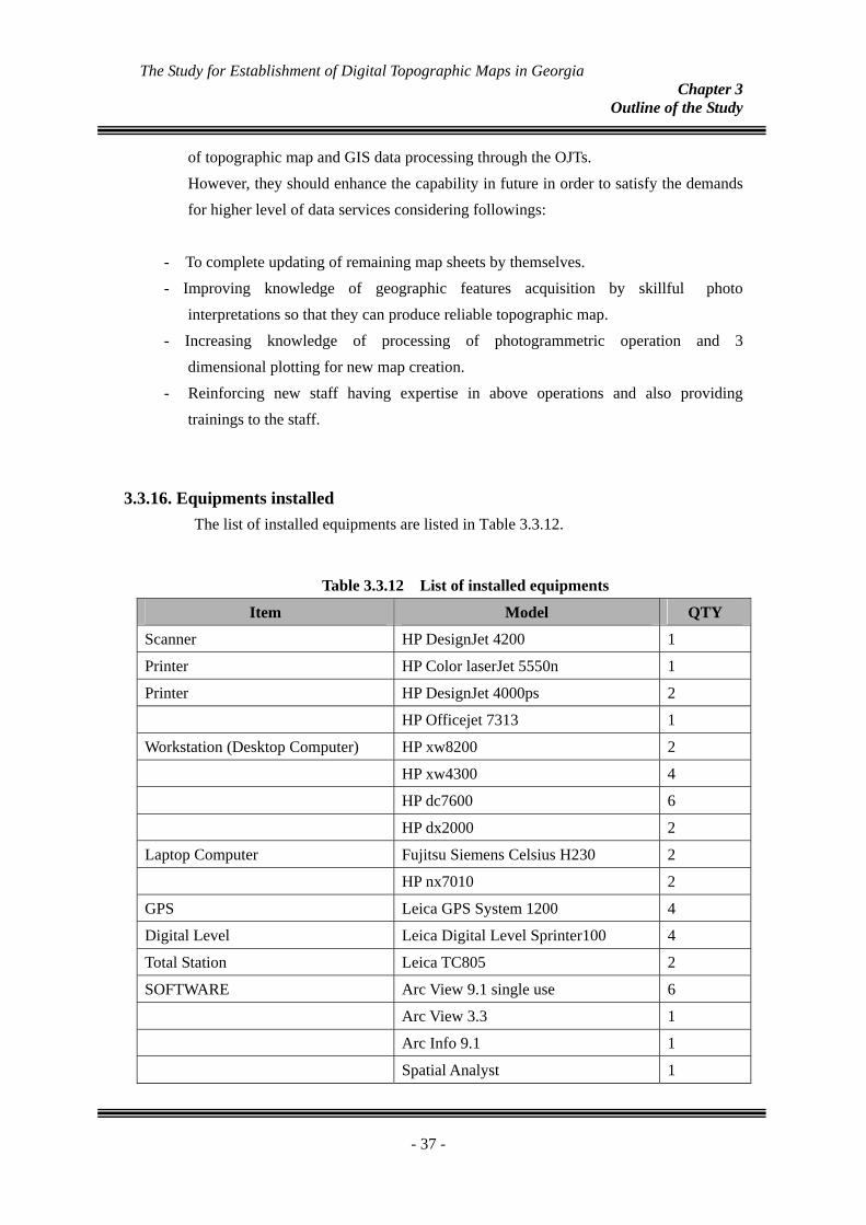
3.3.16. Equipments installed The list of installed equipments are listed in Table 3.3.12.
Table 3.3.12 List of installed equipments
Item Model QTY
Scanner HP DesignJet 4200 1
Printer HP Color laserJet 5550n 1
Printer HP DesignJet 4000ps 2
HP Officejet 7313 1
Workstation (Desktop Computer) HP xw8200 2
HP xw4300 4
HP dc7600 6
HP dx2000 2
Laptop Computer Fujitsu Siemens Celsius H230 2
HP nx7010 2
GPS Leica GPS System 1200 4
Digital Level Leica Digital Level Sprinter100 4
Total Station Leica TC805 2
SOFTWARE Arc View 9.1 single use 6
Arc View 3.3 1
Arc Info 9.1 1
Spatial Analyst 1
- 37 -

The Study for Establishment of Digital Topographic Maps in Georgia Chapter 3
Outline of the Study
3D Analyst 1
Network Analyst 1
ERDAS IMAGINE 8.7 Professional 1
Virtual GIS 1
Leica LPS DTM 1
Leica LPS PRO600 1
Autodesk CAD 2
- 38 -
The Study for Establishment of Digital Topographic Maps in Georgia Chapter 4
Issues to be considered in future
Chapter 4. 4.1.
4.2.
Issues to be considered in future
Counter part organizational Development
During the period of this Project, the counterpart has gone through organizational change two times. At present, with the inclusion of Geology staff, its name is Geology-Cartography and Geodesy Services (GCGS) and is under Ministry of Environment Protection and Natural Resources. In future, with the concept of increment in its mapping activities, more resources will be required. Thus, to develop this organization for producing and managing the map data including topographic in future, development in the following aspects will be needed, such as:
Increment in the office infrastructure Addition/upgrading of Hardware and Software Increment in the number of staff. Also, along with In-house training, there should
be provision of getting staff training at other agency or abroad wherever suitable. Allocation of Budgetary plan for the above points. Decision regarding mid/long-term geographic information maintenance plan
Strategy to maintain map of remaining area
The reform of the counterpart’s organization and the resulting degradation of their skill level have inevitably trimmed down the land to be mapped in the OJT, leaving approximately 6,000 km2 out of the originally-planned area unmapped. This area is equivalent to 10 map sheets based on the new map width. Considering that the GCGS will have to vectorize the area by themselves using the technologies transferred in the project, the following measures specifically need to be addressed in addition to the issues raised above.
A. To complete the remaining updating of the map sheets, the counterpart acquired
basic skills to carry out this work by themselves. B. However more elaborate practice will be needed in terms of improving
knowledge and skills of geographic features acquisition by skillful photo interpretations so that they can produce reliable topographic maps.
C. The possibility of self-production of new maps is limited in the method by
updating at this moment. It is mainly because of that their skills and knowledge
- 39 -
The Study for Establishment of Digital Topographic Maps in Georgia Chapter 4
Issues to be considered in future
do not reach a sufficient level so as to challenge the professional process through the photogrammetric operation and 3 dimensional plotting(stereo scopic feature capturing ) for new map creation.
1) Adjustment of moved technology to do update technology in map to continuous business.
2) Improvement of aerial photograph interpretation technology for accurate grasp of geographic information.
3) Not only update of the map data but also acquisition of features under three dimension environment by training of basic Photogrammetry technology.
4) Securing finance for the implementation;
Any department in the Georgian Ministry of Environment Protection and Natural
Resources is financially restricted; hence it will most likely be extremely difficult to secure budgets necessary for early implementation of the above development work. Accordingly, it is a practical option to give thoughts to allocating of a part of revenues from sale of map data to the financial source of the updating work. According to a mid-level sales forecast, the revenue from direct sales of printed
maps (as mentioned in section 3.3.12.) will be approximately US$37,000 per year. If about 50% of the revenue is allocated to the budget for map updating for remaining sheets, approximately US$38,000 will be secured in two years, which will suffice the necessary development cost described above.
Based on the above calculation, the updating of the remaining ten map sheets will roughly require:
* 60 months/12 months → 5 years if one person is assigned. * 30 months/12 months → 2.5 years if two persons are assigned. * 20 months/12 months → 1.7 years if three persons are assigned.
4.3.
4.3.1.
Issues related to promotion of data use in future
Establishment of data sales system Though, the provision for distribution of topographical map is shown in a basic chart in the country, up to now it is lacking in practice. Moreover, the road of the use spread of the geographic information has been shut so far. It is hoped to build up the system that the map data including the digital data maintained this time can be supplied to a wide user through the market window such as the book shops as soon as possible. The construction of the system for selling maps is hoped employing following ways with
- 40 -
The Study for Establishment of Digital Topographic Maps in Georgia Chapter 4
Issues to be considered in future
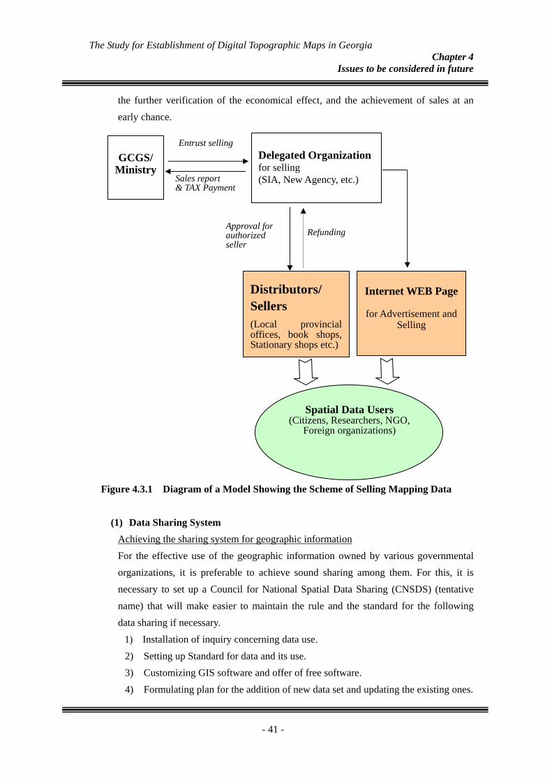
the further verification of the economical effect, and the achievement of sales at an early chance.
Figure 4.3.1 Diagram of a Model Showing the Scheme of Selling Mapping Data
RefundingApproval forauthorized seller
Entrust selling
Sales report & TAX Payment
Distributors/ Sellers (Local provincial offices, book shops, Stationary shops etc.)
Delegated Organization for selling (SIA, New Agency, etc.)
Internet WEB Page
for Advertisement and
Selling
Spatial Data Users (Citizens, Researchers, NGO,
Foreign organizations)
GCGS/
Ministry
(1) Data Sharing System Achieving the sharing system for geographic information For the effective use of the geographic information owned by various governmental organizations, it is preferable to achieve sound sharing among them. For this, it is necessary to set up a Council for National Spatial Data Sharing (CNSDS) (tentative name) that will make easier to maintain the rule and the standard for the following data sharing if necessary.
1) Installation of inquiry concerning data use. 2) Setting up Standard for data and its use. 3) Customizing GIS software and offer of free software. 4) Formulating plan for the addition of new data set and updating the existing ones.
- 41 -
The Study for Establishment of Digital Topographic Maps in Georgia Chapter 4
Issues to be considered in future
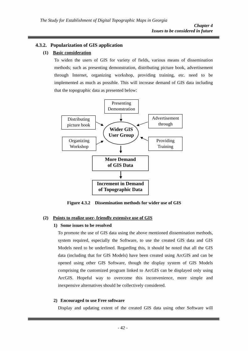
4.3.2. Popularization of GIS application (1) Basic consideration
To widen the users of GIS for variety of fields, various means of dissemination methods; such as presenting demonstration, distributing picture book, advertisement through Internet, organizing workshop, providing training, etc. need to be implemented as much as possible. This will increase demand of GIS data including
that the topographic data as presented below:
Presenting Demonstration
Distributing picture book
Advertisement through
Wider GIS User Group
More Demand of GIS Data
Increment in Demand of Topographic Data
Providing Training
Organizing Workshop
Figure 4.3.2 Dissemination methods for wider use of GIS
(2) Points to realize user- friendly extensive use of GIS 1) Some issues to be resolved
To promote the use of GIS data using the above mentioned dissemination methods, system required, especially the Software, to use the created GIS data and GIS Models need to be underlined. Regarding this, it should be noted that all the GIS data (including that for GIS Models) have been created using ArcGIS and can be opened using other GIS Software, though the display system of GIS Models comprising the customized program linked to ArcGIS can be displayed only using ArcGIS. Hopeful way to overcome this inconvenience, more simple and inexpensive alternatives should be collectively considered.
2) Encouraged to use Free software Display and updating extent of the created GIS data using other Software will
- 42 -
The Study for Establishment of Digital Topographic Maps in Georgia Chapter 4
Issues to be considered in future
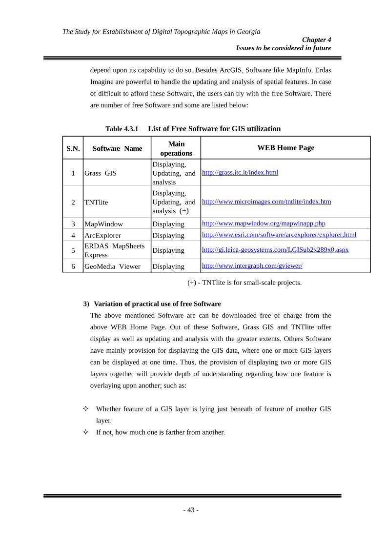
depend upon its capability to do so. Besides ArcGIS, Software like MapInfo, Erdas Imagine are powerful to handle the updating and analysis of spatial features. In case of difficult to afford these Software, the users can try with the free Software. There are number of free Software and some are listed below:
Table 4.3.1 List of Free Software for GIS utilization
1 Grass GISDisplaying,Updating, andanalysis
http://grass.itc.it/index.html
2 TNTliteDisplaying,Updating, andanalysis (÷)
http://www.microimages.com/tntlite/index.htm
3 MapWindow Displaying http://www.mapwindow.org/mapwinapp.php
4 ArcExplorer Displaying http://www.esri.com/software/arcexplorer/explorer.html
5 ERDAS MapSheetsExpress Displaying http://gi.leica-geosystems.com/LGISub2x289x0.aspx
6 GeoMedia Viewer Displaying http://www.intergraph.com/gviewer/
S.N. WEB Home PageSoftware Name Mainoperations
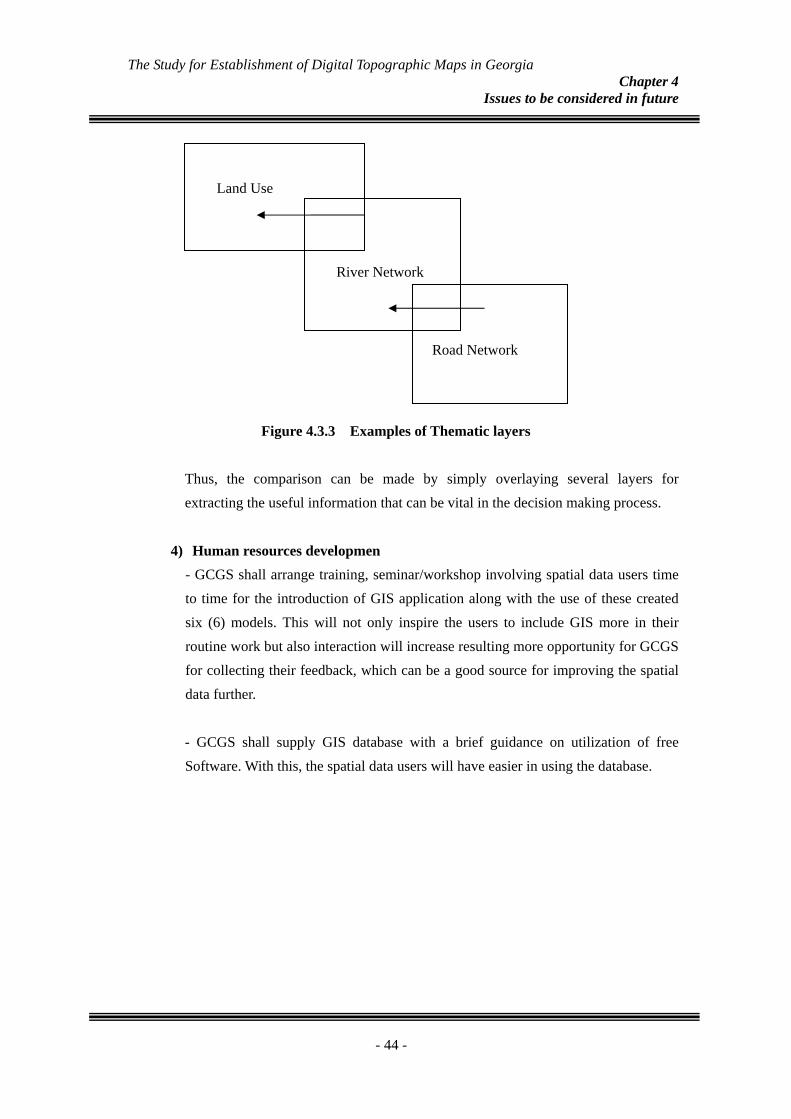
3) Variation of practical use of frThe above mentioned Softwareabove WEB Home Page. Out display as well as updating and have mainly provision for displacan be displayed at one time. Tlayers together will provide depoverlaying upon another; such as Whether feature of a GIS lay
layer. If not, how much one is farther
-
(÷) - TNTlite is for small-scale projects.
ee Software are can be downloaded free of charge from the of these Software, Grass GIS and TNTlite offer analysis with the greater extents. Others Software ying the GIS data, where one or more GIS layers hus, the provision of displaying two or more GIS th of understanding regarding how one feature is :
er is lying just beneath of feature of another GIS
from another.
43 -
The Study for Establishment of Digital Topographic Maps in Georgia Chapter 4
Issues to be considered in future
Land Use
Road Network
River Network
Figure 4.3.3 Examples of Thematic layers
Thus, the comparison can be made by simply overlaying several layers for extracting the useful information that can be vital in the decision making process.
4) Human resources developmen - GCGS shall arrange training, seminar/workshop involving spatial data users time to time for the introduction of GIS application along with the use of these created six (6) models. This will not only inspire the users to include GIS more in their routine work but also interaction will increase resulting more opportunity for GCGS for collecting their feedback, which can be a good source for improving the spatial data further.
- GCGS shall supply GIS database with a brief guidance on utilization of free Software. With this, the spatial data users will have easier in using the database.
- 44 -


