Geography Inquiry Monica Hynds, Saint Paul Public Schools, Minnesota 8 th grade Geography Ten 50-minute class periods December 2011 Maps, charts, text, historical and artistic visuals will involve students in an exploration of the human environment interaction around Mexican agriculture and how it affects where people live and what people eat. Students will do the work of a geographer by asking geographic questions and then acquiring, organizing, predicting, and interpreting geographic information in order to answer geographic questions. 8 th grade World Geography – Human Environment Interaction standard – North America, Mexico or Latin America Geography Skills – Use visuals, maps, and text to analyze physical and human patterns in order to make predictions. Common Assessment Task #1 Big Ideas Essential/ Overarching Question Concepts: Need to Know Guiding Questions Skills: Be Able To Do What people produce (grow) and consume (eat) depends on location (where people live) How does the environment affect where and how people live? Physical features Biomes/climate Natural resources Population density What are the major physical features and biomes in Mexico? How do biomes and physical features affect settlement patterns (where people live)? Locate the biomes and physical features of Mexico. Locate/explain where people live based on physical features and biomes. Task Synopsis : Reflect and respond to Mexican population density predictions. After predicting the population density of Mexico, based on physical features and biomes, by shading on a blank state map of Mexico, students reflect in writing about their correct and incorrect predictions.
Transcript
Geography Inquiry Monica Hynds, Saint Paul Public Schools, Minnesota
8th grade Geography Ten 50-minute class periods
December 2011 Maps, charts, text, historical and artistic visuals will involve students in an exploration of the human environment interaction around Mexican agriculture and how it affects where people live and what people eat. Students will do the work of a geographer by asking geographic questions and then acquiring, organizing, predicting, and interpreting geographic information in order to answer geographic questions. 8th grade World Geography – Human Environment Interaction standard – North America, Mexico or Latin America Geography Skills – Use visuals, maps, and text to analyze physical and human patterns in order to make predictions. Common Assessment Task #1 Big Ideas Essential/
Overarching Question
Concepts: Need to Know
Guiding Questions Skills: Be Able To Do
What people produce (grow) and consume (eat) depends on location (where people live)
How does the environment affect where and how people live?
Physical features Biomes/climate Natural resources Population density
What are the major physical features and biomes in Mexico? How do biomes and physical features affect settlement patterns (where people live)?
Locate the biomes and physical features of Mexico.
Locate/explain
where people live based on physical features and biomes.
Task Synopsis: Reflect and respond to Mexican population density predictions. After predicting the population density of Mexico, based on physical features and biomes, by shading on a blank state map of Mexico, students reflect in writing about their correct and incorrect predictions.
Hynds – Geography Inquiry p. 2
Lessons that prepare students for assessment task: Guiding Question: What are the major physical features and biomes in Mexico? 1. Exploration of biomes and physical features of Mexico (2–3 class periods) Students could make their own physical system map of Mexico and/or respond to questions about how location, landforms and climate impact where people live using biome and physical feature maps from a classroom atlas or from the Internet links below. (Student-created physical maps will be used in Assessment Task #2) Guiding Question: How do biomes and physical features affect where people live? 2. Students predict population density of Mexico (2 class periods) Predictions are based on physical features and biomes. Students shade a blank Mexico state map using at least 3 categories (most densely populated, “in the middle”, least densely populated).
a. Individual students draft their predictions on a blank state map of Mexico while viewing physical feature and biome maps of Mexico. Make sure a legend and map elements are included. Transparencies of each map could be used to overlay different features.
b. Share predictions with one partner. Students take turns asking why their partner made specific predictions, what evidence was used (referencing maps) and actively listening to response.
c. Students finalize individual predictions.
d. Students view actual population density map and reflect on where their predictions were correct and where they were incorrect, using the reflection chart.
e. Explore population cartogram maps with partner. Lesson Resources (attached): Common Assessment Task #1 and Scoring Guide Task #1 Physical feature maps of Mexico and biome map Blank state map of Mexico (2 per student: 1 draft and 1 final) Population density map of Mexico Population map of Mexican states Population density reflection chart Population cartogram map (a for each set of partners)
Hynds – Geography Inquiry p. 3
Geography Inquiry Common Assessment Task #1
Overarching/Essential Question: How does the environment affect where and how people live? Reflect & Respond Reflect on the similarities and differences between your predictions and the actual population density of Mexico. You may use your atlas, prediction maps, and reflection chart. Review the scoring guide 1. Explain one correct prediction and one incorrect prediction and the physical features that lead you to each prediction. 2. For your incorrect population prediction: Why was it different? 3. Write one question that you still have about physical features and where people live in Mexico.
Hynds – Geography Inquiry p. 4
Geography Inquiry Scoring Guide Task #1
Overarching/Essential Question: How does the environment affect where and how people live? Exceeds Proficiency Criteria for the “Proficient” category have been successfully met. Advanced work may include insightful relationships, future implications, connections
that relate to student’s experiences or an exploration of contradictions. *Proficient – Start Here One correct population prediction is explained and linked to physical features/biomes. One incorrect population prediction is explained and linked to physical
features/biomes. Response includes reflection on incorrect population prediction. Response includes one question about where people live in Mexico.
Progressing Three criteria in the “Proficient” category have been met. More work is needed.
Does Not Meet Standard/Expectations Two or one criteria in the “Proficient” category have been met. Work must be completed.
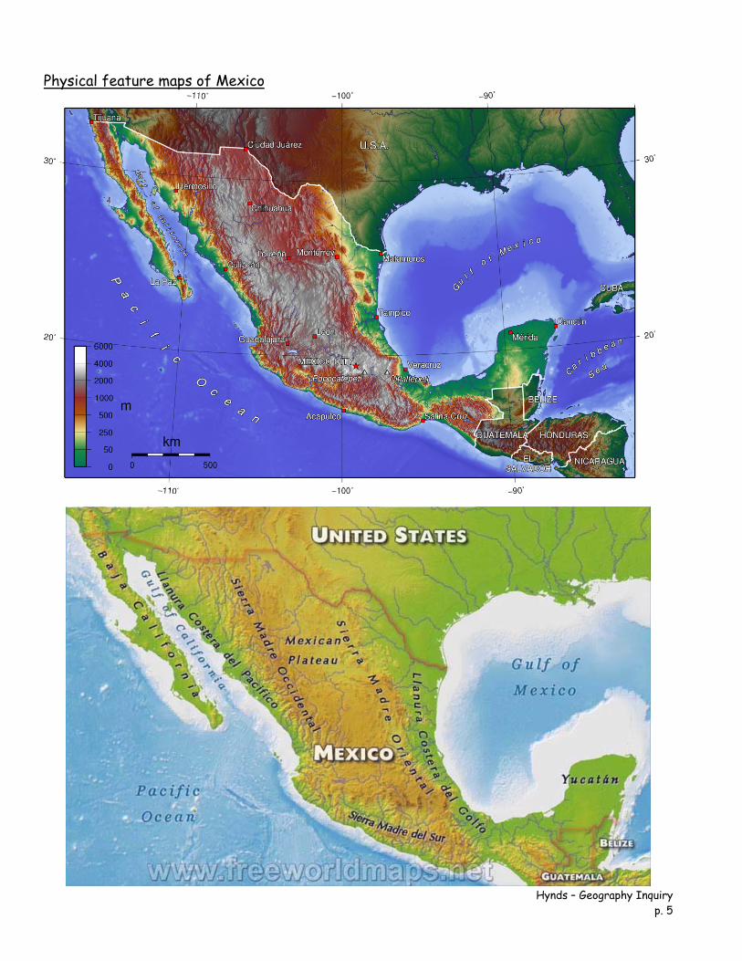
Physical feature maps of Mexico
Hynds – Geography Inquiry p. 5
Hynds – Geography Inquiry p. 6
Blank state map of Mexico
Hynds – Geography Inquiry p. 7
Population density map of Mexico
Hynds – Geography Inquiry p. 8
Population map of Mexican states
Hynds – Geography Inquiry p. 9
Hynds – Geography Inquiry p. 10
Population Density Reflection chart Correct Predictions Evidence 1.
1.
2.
2.
Incorrect Predictions Evidence Why were you incorrect? 3.
3.
3.
4.
4.
4.
Cartogram of Mexico’s population distribution
Cartograms are maps in which the sizes of areas (such as states or countries) have been distorted to reflect some numerical value applying to that area. They are a form of topological transformation. To help make the end-product recognizable, the positions of major places are kept as close to their conventional spatial arrangement as possible. Drawing such maps used to be a very time-consuming and trial-and-error process. Only in the last decade or so has it become possible to make such maps using sophisticated computer programs. The cartogram offers a striking image of the dominance of Mexico’s three main cities—Mexico City, Guadalajara and Monterrey—and their surrounding areas in the nationwide distribution of population.
What people produce (grow) and consume (eat) depends on location (where people live)
Why do people grow and eat what they do? (World History – WH) Beginning of Maize cultivation in Mesoamerica and its’ uses: consumption, religious, artistic.
Crops Crop requirements and their uses Value Culture
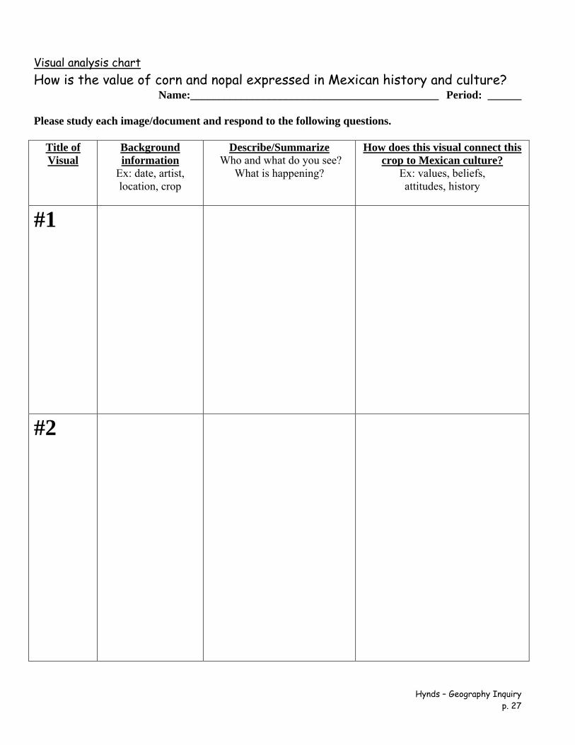
What crops are grown in Mexico and what does each crop need to thrive?
How is the value of corn and nopal expressed in Mexican history and culture?
Design a map of Mexico labeling physical systems and where specific Mexican crops are grown and explain why they are grown in that location.
Written response:
Using at least two specific Mexican crop examples answer the question: Why do Mexicans grow and eat what they do?
Task Synopsis: Why do Mexicans grow and eat what they do? Students respond in writing by using at least two specific Mexican crop examples as well as their value in past and/or present Mexican culture.
Hynds – Geography Inquiry p. 13
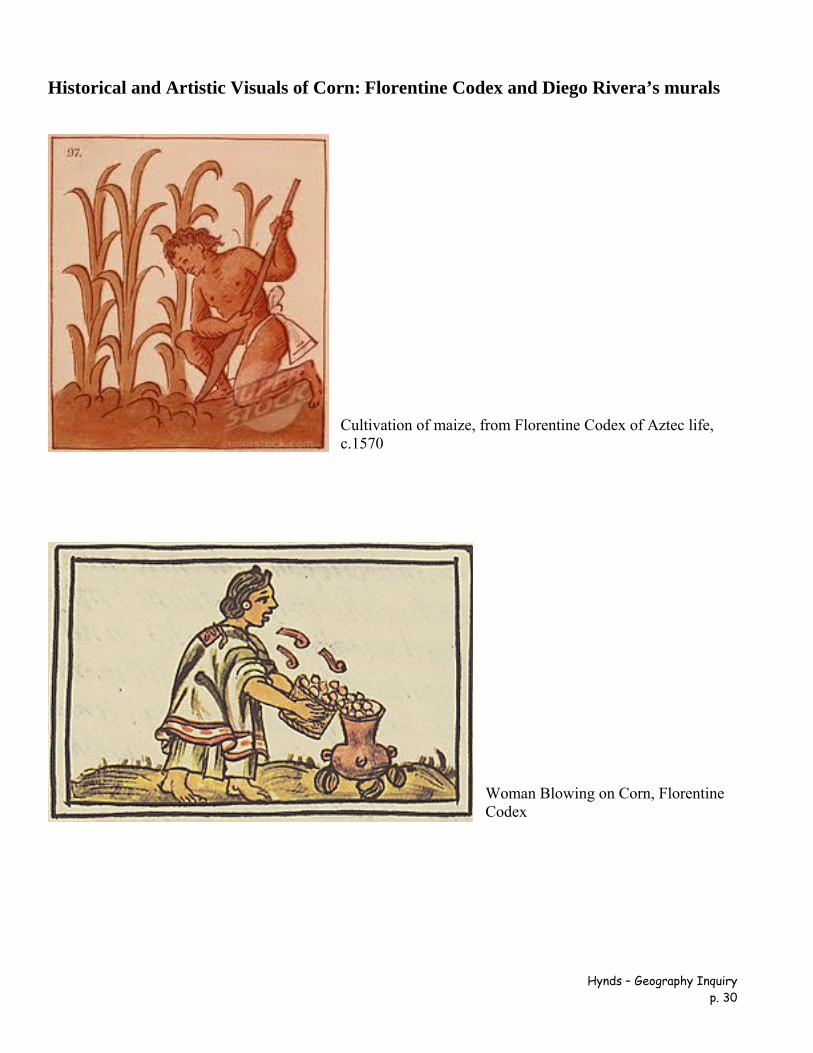
Lessons that prepare students for assessment task: Guiding Question: What crops are grown in Mexico and what does each crop need to thrive? 1. Use crop grid to organize crop requirements for corn, nopal, chiles, and coffee Articles, maps and graphs (1–2 days) http://geo-mexico.com/?tag=agriculture 2. Use physical systems map made in preparation of common assessment task #1. Add locations where the following crops are grown: corn, nopal, chiles, coffee, honey (1–2 days) http://geo-mexico.com/?tag=agriculture Guiding Question: How is the value of corn and nopal expressed in Mexican culture? 3. Explore historical and artistic representations of corn and nopal in Mexican culture using primary sources and a visual organizer for analysis. (2–4 days) Lesson Resources (attached): Common Assessment Task #2 and Scoring Guide Task #2 Students will need a climate (temperature & precipitation), elevation, landform and crop maps of Mexico, classroom atlas or online resources. Can be found at the following sites: http://soils.usda.gov/use/worldsoils/mapindex/ http://go.hrw.com/atlas/span_htm/
Crop chart Corn map and article Nopal articles Chile articles and map Coffee map and article Honey map, graph, and article Visual analysis chart Historical and artistic visuals of corn and nopal Additional Internet Resources: Corn
Article: “Sin Maiz, No Hay Pais, Without Corn There is No Country” http://mexicocooks.typepad.com/mexico_cooks/2008/06/sin-ma%C3%ADz-no-hay-pa%C3%ADs-without-corn-there-is-no-country.html?cid=119430168
Overarching/Essential Question: Why do people grow and eat what they do?
Reflect & Respond Use at least two specific Mexican crop examples to answer the question: Why do Mexicans grow and eat what they do? 1. Include the crops valued in past and present Mexican culture. 2. Use your physical and crop maps, crop charts and classroom atlas. 3. Review the scoring guide
Hynds – Geography Inquiry p. 16
Geography Inquiry Scoring Guide Task #2
Overarching/Essential Question: Why do people grow and eat what they do? Exceeds Proficiency Criteria for the “Proficient” category have been successfully met. Advanced work may include insightful patterns and relationships, future implications
or connections not explored during the lessons. *Proficient – Start Here At least two crop requirements are described. Crop requirements are linked to physical systems (landforms, biomes) and specific
Mexican locations. At least one crop is related to past and present Mexican culture. Response meets essay requirements.
Progressing Three criteria in the “Proficient” category have been met. More work is needed.
Does Not Meet Standard/Expectations Two to one criteria in the “Proficient” category have been met. Work must be completed.
Hynds – Geography Inquiry p. 17
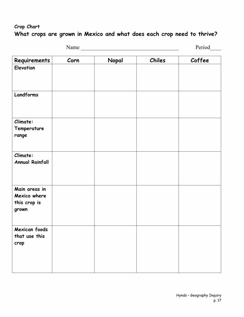
Crop Chart What crops are grown in Mexico and what does each crop need to thrive?
Name ___________________________________ Period____
Requirements Corn Nopal Chiles Coffee Elevation
Landforms
Climate: Temperature range
Climate: Annual Rainfall
Main areas in Mexico where this crop is grown
Mexican foods that use this crop
Corn
Source: http://www.commodityalmanac.com/futures-fast-facts/corn-mexico-map.jpg. Food speculation fuels a tortilla crisis in Mexico The Ecologist Film Unit has produced an excellent 8-minute video on how financial speculation on corn (maize) has led to a dramatic rise in the price of corn tortillas, with potentially disastrous effects for the health and well-being of the many of Mexico’s poorest. Reporter Tom Levitt’s video, accompanied by text, presents a compelling case, one which would be an excellent starting-point for class discussions. Two short quotes set the scene: “For many Mexicans, particularly the estimated 40 million living on less than $5 a day (£3), tortillas account for almost half of their average daily calorie intake. As a whole, the country consumes 23 times more maize than rice.” “In 2000 there was $6 billion invested in commodities, by 2011 it was $340 billion, of which $126 billion, according to data from Barclays Capital, is reported to be invested in food. The vast majority of this new investment has been by speculators with no interest in the agricultural sector or in actually taking delivery of the commodity.” The result? Higher prices for corn, greater unpredictability in prices, and adverse changes to the diet of tens of thousands, as corn becomes more expensive than meager household budgets permit. The video is a powerful indictment of the harm being done to ordinary people in many parts of the developing world by rich-world market speculators and investment banks. Source: http://geo-mexico.com/?p=5286.
Nopal Altitude - Above all, altitude is the key to a successful, prosperous field of Nopal. The three largest producing states all have altitudes exceeding 2,000 meters. We have taken advantage of this key requirement by finding the ideal growing conditions. Our farms situated on a steep pine forested slope (2,400 meters) have one of the best altitude and climatic conditions available to grow the highest quality naturally grown Nopal. Temperature - An extended season of hot or cold weather can greatly reduce the optimum production of Nopal, The temperature at our farms is at the optimum, equal to that of Milpa Alta fields and without the pollution hazards of Mexico City. Ideal temperatures should be annual mean of 17–24 degrees 65ºF–85ºF. Water - A plentiful supply of this vital nutrient through our rainy season guarantees exceptional quality and production without needing artificial irrigation techniques. Source: http://www.nopalexport.com/Growing.htm. What is Nopal
Nopal Cactus, at times referred to in English as “Prickly Pear”, “Indian Fig” or "Barbary Fig" is scientifically categorized as Opuntia Spp, a generic name referring to over 200 species of the Opuntia cacti family. Here in this section we will attempt to distinguish between the different varieties of edible types of these Cacti and show what is actually considered to be the vegetable and fruit variety of Cacti, known popularly as the Nopal cactus. Nopal cactus vegetable variety known in botany as Opuntia ficus indica or OFI, is the vegetable
and fruit variety of the Opuntia Spp species with a 12,000 year historical record. Originating in the volcanic region of Mesoamerica now known as Mexico, Nopal OFI has been offering mankind this staple food and nutritional plant for thousands of years and therefore, many thousands of years before the Aztecs migrated to this Mesoamerican region.
The prophetic Nopal Vision of Aztec civilization in Mesoamerica (Mexico) was founded on a myth or legend. The popular belief that “During the fourteenth century, [the god] Huitzilopochtli told the Aztec chieftain that their new homeland would be on the island in Lake Texcoco, and when they reached the island they were to look for an eagle eating a snake perched on a cactus growing from a rock or cave surrounded by water. This would be the location where they were to build their city and honor him.” They found this location and began to build their city around the year 1325 AD. Aztec translation for Nopal, in the native nahuatl language = Nochtli. Thus the name for the new city “Tenochtitlan” or “the place of the Nopal cactus.”
Tenochtitlan is now Mexico City, yet the Aztec Nopal vision is preserved on the National flag. For this reason we have named our Nopal Co-op grower society Tenochtli. As we are very close to the ancient lake Texcoco.
So central was Nopal to the many indigenous tribes of Mexico that they are the root of Mexico City's Aztec name ‘Tenochtitlan’ meaning “place of the cactus.” In cases of drought, Nopal was the lifeblood of ancient cultures in Mexico for it was both food for the indigenous tribes and for their livestock. As the historical archives suggest Nopal was used to soothe wounds as it was used to stiffen cloth, purify water and waterproof paint. It strengthened mortar and was used fence off valued animals and to protect habitats from wild ones. Cattle that grazed on the Nopales were said to develop a special flavor to their meat and milk.
Highly adaptable to a variety of climates, Nopal cactus cross-polinates and propagates easily. Nopal spread throughout the North and South American continents and Caribbean in the Pre-Colombian Period. Nopal was treasured by 15th century explorers and explorers and European travelers for its alleged natural ability to prevent scurvy and stave off hunger and therefore it was consequently introduced to Europe, Asia and Africa where it rapidly adapted to various environments and proliferated into the nearly 200 species that continue to be botanically defined.
The variety of Nopal cactus that we grow is the Opuntia Ficus Indica variety or OFI This variety of Nopal cactus is prized as the rich tasting and tender vegetable or edible variety of Nopal Cactus. When the term ‘Nopal’ is used in Mexico it refers to this edible variety. When the term ‘Nopalitos’ is mentioned, it refers to the baby Nopal pads or also the smaller tender leaves once they have been cut up and prepared for eating.
Hynds – Geography Inquiry p. 20
There are two principal fresh food crops derived from the Nopal ‘Opuntia Ficus Indica’ Cactus. One is the “Nopalitos” that are the Nopal cactus pads or leaves and the other crop is the Nopal “Tuna” or the ‘prickly pear’ fruit of the Nopal Cactus. ‘Nopalitos’ the vegetable variety Nopal pads are native to the high altitude mountain volcanic rich soil of South Central Mexico. The ‘Tuna’ or ‘Prickly pear’ fruit Nopal cactus is also primarily grown within our region. Source: http://www.nopalexport.com/What.htm.
Chiles Chiles, one of Mexico’s heritage crops Chiles (Capsicum spp.) have been cultivated in Mexico for centuries and are a vital ingredient in Mexico’s traditional cuisine, recently recognized by UNESCO as an “Intangible Cultural Heritage of Humanity.” Spicy chiles also have numerous medicinal uses. Graphical representations of chiles have even been used as a national symbol. Chiles are native to Mexico and Central America. Evidence for chiles in the diet of indigenous groups in Puebla’s Tehuacán Valley dates back at least as far as 6500BC; by 4100BC, the plant was already domesticated. There are more than 100 varieties of chiles, grouped into 22 groups of green chiles and 12 of dried chiles. Green chiles are by far the most important in volume and value of production and trade. Mexico remains the world’s leading exporter of green chiles and is the sixth largest exporter of dried chiles. The world’s leading producer of green chiles, almost entirely for domestic consumption, is China. The ideal conditions for cultivating chiles are:
growing season temperatures of 18–27 ̊ºC daytime and 15–18º C during the night. rainfall of 600–1250 mm/yr, with no marked dry season. light, humus-rich soils with adequate moisture retention and drainage soils with a pH between 5.5 (slighty acidic) and 7.0 (neutral) growing season of at least 120 days
Crop yields can be adversely affected by: plagues, plant diseases, climatic hazards, such as hailstorms, rainstorms (fields need efficient drainage systems) and frost,
the risk of which is countered by burning waste to create smoke to maintain temperatures above freezing
Time frame for cultivation on commercial chile farms, seeds are usually sown in enclosed, heated, nursery beds, since
temperatures of 20–24ºC are considered ideal for germination seedlings are transplanted after 25-35 days when they are about 10–20cm in height – optimum
yields require 20,000–25,000 plants per hectare the first flowers appear 1–2 months later, by which time the plant is 30–80 cm tall the first green chiles ripen about a month after that; chiles can then be picked every week or so for
up to 3 months in rain-fed fields, or sometimes over an even longer period in irrigated fields. In ideal circumstances, harvesting is possible all year. There are two major, overlapping harvest periods each year, with a fall-winter crop from December-August, and a spring-summer crop from June to March. Yields vary greatly, reflecting different qualities of soil, water supply and technification employed. The average yield across Mexico is 14–15 metric tons/hectare. Yields in Zacatecas (which has a larger cultivated area of chiles than any other state in Mexico) are only 7 tons/ha, while yields in Sinaloa reach as high as 40 tons/ha. Source: http://geo-mexico.com/?p=3567.
Cultivation location, production volumes and value Mexico’s total annual chile production is around 2 million tons [cf China’s 14.3 million tons]. By variety, about 30% of production is jalapeño chiles, followed by serrano (10.9%), poblano (9.7%) and morrón (8.1%). These four account for 60% of production:
jalapeño (619,000 tons in 2009): Chihuahua (42%), Sinaloa (12.9%), Jalisco (6.6%) and Michoacán (6.3%)
serrano (217,000 tons): Tamaulipas (38.7%) and Sinaloa (30.9%) poblano (192,000 tons): spread between 16 states, led by Zacatecas (32.7%), Sinaloa (20.6%) and
Production of chiles in Mexico, 2009. Source: SAGARPA 2010 The map shows total production volume on a state-by-state basis. In summary, 2 out of every 3 green chiles grown in Mexico come from Chihuahua, Sinaloa, Zacatecas and San Luis Potosí. Source: http://geo-mexico.com/?p=3560.
BEAN BELT: From humble origins in Africa, coffee cultivation wandered east and west, eventually forming a belt roughly bounded by the Tropics of Cancer and Capricorn. Growing regions typically offer moderate sunshine and rain, steady temperatures around 70ºF (20ºC), and rich, porous soil. In return the delicate tree yields beans that are an economic mainstay for dozens of countries and about 25 million people—and, among natural commodities, have a monetary value surpassed only by oil. Of the two main coffee trees, arabicas beget the better beans—and about 70 percent of the harvest. The harsher beans of the hardier robusta tree account for about 30 percent. Source: http://www.nationalgeographic.com/coffee/map.html Characteristics of the Coffee Plant Coffee is an evergreen tree (shrub) native to northern Africa. Coffee trees are self-pollinating and produce fruit called “cherries” that ripen from green to yellow and then to red when mature. Ripe cherries have several layers; red skin, a sweet light pulp, a membrane called “parchment skin” or pergamino, and an inner thin membrane called “silver skin.". These layers must be removed prior to roasting, though some silverskin often remains attached. Each cherry has two green coffee seeds that are round/oval in shape and are flat on one side with a center cut. Coffee beans are the seeds of the coffee cherry. While most coffee cherries contain two beans, 5 to 10 percent of the time, only one bean is produced in the cherry. This is called a “peaberry.” Some coffee trees have the potential to grow to a height of 30 to 40 feet. However, most are kept much shorter for ease of harvest. The average coffee tree bears enough cherries each season to produce between 1 and 1½ pounds of roasted coffee. The soil, climate, altitude, and surrounding plants that a coffee tree is exposed to during growth affect the flavor of the beans it produces. All coffee beans come from plants in the genus Coffea. Although there are thousands of species of plants within this genus, only two are of commercial importance: C. arabica, and C. canephora, the latter more commonly called C. robusta. Both species are tropical evergreens, are intolerant to frost, and belong to the family Rubiaceae. Arabica is genetically distinct: it has four sets of chromosomes, whereas robusta has only two. Arabica (a-rab-i-ca) coffee represents 75% of the world coffee production. The Arabica bean yields an
average of 300 pounds of beans per acre. In general, Arabica coffee grows best between 2,000 and 6,000 feet above sea level, in warm climates along the equator. The predominant producing regions are Central America, South America and Eastern Africa. In subtropical conditions, Arabica coffees thrive at lower altitudes, from as low as 1,000 feet in the Kona region of Hawaii, to about 4,000 feet in regions of Mexico and a few other locations. Closer to the equator, coffee tends to thrive at higher altitudes, from 3,500 feet up to 9,500 feet in Ecuador. The quality and taste of Arabica beans differ between varieties and growing regions--the same variety grown in different parts of the world will taste different. These taste notes can be as varied as berries (blueberry is often particularly noted in Ethiopian Harrar), earthy (a characteristic associated with Indian and Indonesian coffees,) citrus (common with Central Americans), or chocolate. The older varieties of Arabica produce the best flavor, and these somewhat fragile, older varietals require partial shade to protect the cherries from getting too much sun. Although the best tasting arabicas are grown at high elevation, the overnight temperature cannot drop below freezing; Arabica trees cannot survive frost. Elevations between 4,000 and 6,000 feet provide cooler nighttime temperatures so the cherry's growth is slower, yielding more concentrated flavors and better acidity. Volcanic soil is rich in nutrients and provides good drainage. The Growing of Coffee Approximately 25 million acres worldwide are devoted to cultivating coffee. The ideal growing conditions include tropical and sub-tropical temperatures of 68ºF–75ºF, abundant sunlight, rich soil, and 60–80 inches of annual rainfall. Vegetative and seedling propagation are used to produce plantings to establish new plantations or replace damaged or unproductive trees. Most plants begin in nurseries, where they are tended for 6–18 months, then are transplanted to the field, where three to five years pass before the first crop. Plant management consists of pruning, weed control, and fertilization to ensure best yields. Coffee trees are susceptible to natural destructive forces, such as climatic changes, insect infestation, and plant diseases such as coffee leaf rust and coffee berry disease (CBD). Source: http://www.melitta.com/fromearthtoyourcup,168.html.
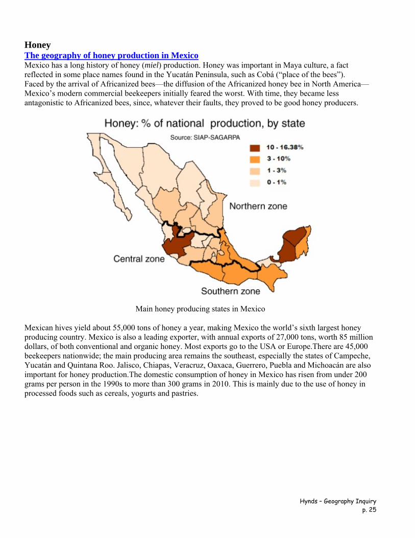
Honey The geography of honey production in Mexico Mexico has a long history of honey (miel) production. Honey was important in Maya culture, a fact reflected in some place names found in the Yucatán Peninsula, such as Cobá (“place of the bees”). Faced by the arrival of Africanized bees—the diffusion of the Africanized honey bee in North America—Mexico’s modern commercial beekeepers initially feared the worst. With time, they became less antagonistic to Africanized bees, since, whatever their faults, they proved to be good honey producers.
Main honey producing states in Mexico Mexican hives yield about 55,000 tons of honey a year, making Mexico the world’s sixth largest honey producing country. Mexico is also a leading exporter, with annual exports of 27,000 tons, worth 85 million dollars, of both conventional and organic honey. Most exports go to the USA or Europe.There are 45,000 beekeepers nationwide; the main producing area remains the southeast, especially the states of Campeche, Yucatán and Quintana Roo. Jalisco, Chiapas, Veracruz, Oaxaca, Guerrero, Puebla and Michoacán are also important for honey production.The domestic consumption of honey in Mexico has risen from under 200 grams per person in the 1990s to more than 300 grams in 2010. This is mainly due to the use of honey in processed foods such as cereals, yogurts and pastries.
The major value of bees in an ecosystem is not for their honey production, but on account of their vital role in the pollination of trees and food crops, a contribution valued in the US alone at more than 10 billion dollars. Views about the pollinating ability of Africanized bees compared to European or native bees are mixed. Some farmers dislike having to cope with potentially aggressive bees. Others claim that Africanized bees are far more efficient pollinators than European bees since they forage more often and at greater distances than their European counterparts. The available evidence does not appear to suggest that the arrival of Africanized bees had any impact on crop yields in Mexico. Source: http://geo-mexico.com/?p=4672.
Historical and Artistic Visuals of Nopal Codex Zempoala Ink on amatl, ca. 1700-43 A Techialoyan, the Codex Zempoala describes the land and records the names, acreage, and boundaries of Zempoala’s districts. Churches, city halls, and houses of tribute-payers are depicted. Also shown are the principal crops cultivated in the area: the maguey plant and nopal cactus. The left page of this document invokes prehispanic origins of ownership through the depiction of the mountain (Tzinquilocantepetl) which established the boundary, and Ixtlilxochitl, royal ancestor and Cortés’ ally. On the right
page, the noble lord and chief Tecpancacaltzin and his son Xilomantzin are depicted. Source: http://publications.newberry.org/aztecs/s4i18.html.
Did You Know? Some national symbols in Mexico are not what they seem Tony Burton
Hynds – Geography Inquiry p. 33
This month, Mexico celebrates her birthday, the anniversary of her independence from Spain. On the evening of September 15, the annual El Grito ceremony is held in town plazas all across the country. For several days prior to this celebration, town plazas are besieged by vendors selling national flags in a tide of nationalistic fervor. The story of the national emblem (used on coins, documents and the flag), an eagle devouring a serpent, while perched on a prickly-pear cactus, is well known. Or is it?
The Mexican crest The conventional version is that this unlikely combination represents a “vision” that was of crucial importance to the Mexica, an ancient tribe originating somewhere in northern Mexico. According to legend, the Mexica were told by their Gods to migrate southwards and establish a new settlement. They would know they had found the right place when they saw an eagle clutching a snake while perched on a nopal cactus. After years of wandering, they finally saw their sign, and began building Tenochtitlan. Tenochtitlan eventually became a large and wonderful city, the capital city of the mighty Aztecs, who presided over a massive empire.
This is a great story, but certain details may not be quite as straightforward as they seem. For starters, were the Mexica really looking for a place where an eagle, serpent and cactus coincided? All the known sources for this legend date from after the early sixteenth century and the Spanish Conquest. Among the early depictions of the founding of Tenochtitlan, many show only an eagle perched on a cactus, with nothing in its talons. Even in those cases where the eagle does have something in its talons, the object being clutched is usually either a bird or a tuna (the fruit of the nopal). Attempts to put the depictions in some kind of chronological order appear to indicate that those with a serpent are later than those with a bird or tuna. Codex Mendoza - the “eagle” As a result, some anthropologists have argued that the conventional story is a revisionist re-interpretation of history. The snake was added some time after the Conquest, perhaps as a potent reminder to the natives that their non-Christian religion (represented by the serpent) had been crushed by Spanish military might (represented by an eagle). To make the story even more confusing, the “eagle” isn't really an eagle at all! The bird depicted in ancient codices, and now shown on the national coat-of-arms, has a crest. The only eagles or members of the eagle family sporting a crest in Mexico are the Harpy Eagle and the various Hawk-Eagles; however, all these birds are confined to tropical southern Mexico. According to ornithologists, the bird on the national crest is most likely to be a Crested Cara-Cara ( Polyborus plancus). The Crested Cara-Cara, a member of the Falconidae family, is common throughout the country. It feeds chiefly on carrion, but also eats insects, frogs and... snakes. So, the story of a Cara-Cara sitting on a nopal cactus eating a tuna has been gradually transformed by time into an Eagle sitting on a cactus devouring a serpent... What is more, September 15 might not be the right day to celebrate anyway, since the first grito actually took place not on September 15 (1810) but in the early morning of September 16. As Mexico celebrates her official birthday, and national symbols are on show everywhere, take a close look, and remember that perhaps not all the symbols you see are quite what most people think they are! ¡Viva la serpiente! ¡Viva el Cara-Cara! ¡Viva México! Copyright 2004 by Tony Burton. All rights reserved. Source: http://www.mexconnect.com/articles/1268-did-you-know-some-national-symbols-in-mexico-are-not-what-they-seem.