+ All Categories
Home > Documents > Peak Charles – Cape Le Grand – Stokes Peak – Class 4, 3km return, 1.5 hours A track leads from...

Peak Charles – Cape Le Grand – Stokes Peak – Class 4, 3km return, 1.5 hours A track leads from...

Date post: 11-Jun-2018
Category:
Upload: vutu
View: 213 times
Download: 0 times
Share this document with a friend
2
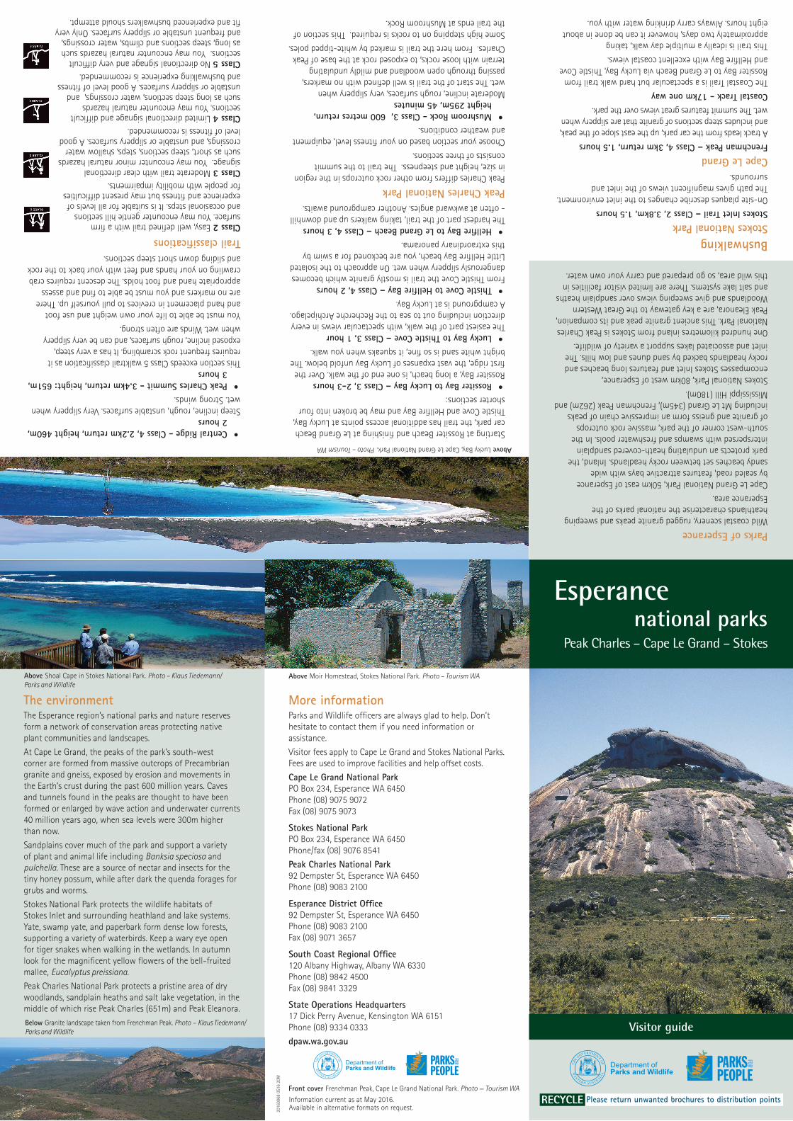
More information Parks and Wildlife officers are always glad to help. Don’t hesitate to contact them if you need information or assistance. Visitor fees apply to Cape Le Grand and Stokes National Parks. Fees are used to improve facilities and help offset costs. Cape Le Grand National Park PO Box 234, Esperance WA 6450 Phone (08) 9075 9072 Fax (08) 9075 9073 Stokes National Park PO Box 234, Esperance WA 6450 Phone/fax (08) 9076 8541 Peak Charles National Park 92 Dempster St, Esperance WA 6450 Phone (08) 9083 2100 Esperance District Office 92 Dempster St, Esperance WA 6450 Phone (08) 9083 2100 Fax (08) 9071 3657 South Coast Regional Office 120 Albany Highway, Albany WA 6330 Phone (08) 9842 4500 Fax (08) 9841 3329 State Operations Headquarters 17 Dick Perry Avenue, Kensington WA 6151 Phone (08) 9334 0333 dpaw.wa.gov.au Parks of Esperance Wild coastal scenery, rugged granite peaks and sweeping heathlands characterise the national parks of the Esperance area. Cape Le Grand National Park, 50km east of Esperance by sealed road, features attractive bays with wide sandy beaches set between rocky headlands. Inland, the park protects an undulating heath-covered sandplain interspersed with swamps and freshwater pools. In the south-west corner of the park, massive rock outcrops of granite and gneiss form an impressive chain of peaks including Mt Le Grand (345m), Frenchman Peak (262m) and Mississippi Hill (180m). Stokes National Park, 80km west of Esperance, encompasses Stokes Inlet and features long beaches and rocky headlands backed by sand dunes and low hills. The inlet and associated lakes support a variety of wildlife. One hundred kilometres inland from Stokes is Peak Charles National Park. This ancient granite peak and its companion, Peak Eleanora, are a key gateway to the Great Western Woodlands and give sweeping views over sandplain heaths and salt lake systems. There are limited visitor facilities in this wild area, so go prepared and carry your own water. Bushwalking Stokes National Park Stokes Inlet Trail – Class 2, 3.8km, 1.5 hours On-site plaques describe changes to the inlet environment. The path gives magnificent views of the inlet and surrounds. Cape Le Grand Frenchman Peak – Class 4, 3km return, 1.5 hours A track leads from the car park, up the east slope of the peak, and includes steep sections of granite that are slippery when wet. The summit features great views over the park. Coastal Track - 17km one way The Coastal Trail is a spectacular but hard walk trail from Rossiter Bay to Le Grand Beach via Lucky Bay, Thistle Cove and Hellfire Bay with excellent coastal views. This trail is ideally a multiple day walk, taking approximately two days, however it can be done in about eight hours. Always carry drinking water with you. • Central Ridge - Class 4, 2.2km return, height 460m, 2 hours Steep incline, rough, unstable surfaces. Very slippery when wet. Strong winds. • Peak Charles Summit - 3.4km return, height: 651m, 3 hours This section exceeds Class 5 walktrail classification as it requires frequent rock scrambling. It has a very steep, exposed incline, rough surfaces, and can be very slippery when wet. Winds are often strong. You must be able to life your own weight and use foot and hand placement in crevices to pull yourself up. There are no markers and you must be able to find and assess appropriate hand and foot holds. The descent requires crab crawling on your hands and feet with your back to the rock and sliding down short steep sections. Trail classifications Front cover Frenchman Peak, Cape Le Grand National Park. Photo — Tourism WA Esperance national parks Peak Charles – Cape Le Grand – Stokes Starting at Rossiter Beach and finishing at Le Grand Beach car park, the trail has additional access points at Lucky Bay, Thistle Cove and Hellfire Bay and may be broken into four shorter sections: • Rossiter Bay to Lucky Bay – Class 3, 2-3 hours Rossiter Bay, a long beach, is one end of the walk. Over the first ridge, the vast expanses of Lucky Bay unfold below. The bright white sand is so fine, it squeaks when you walk. • Lucky Bay to Thistle Cove – Class 3, 1 hour The easiest part of the walk, with spectacular views in every direction including out to sea to the Recherche Archipelago. A campground is at Lucky Bay. • Thistle Cove to Hellfire Bay – Class 4, 2 hours From Thistle Cove the trail is mostly granite which becomes dangerously slippery when wet. On approach to the isolated Little Hellfire Bay beach, you are beckoned for a swim by this extraordinary panorama. • Hellfire Bay to Le Grand Beach – Class 4, 3 hours The hardest part of the trail, taking walkers up and downhill - often at awkward angles. Another campground awaits. Peak Charles National Park Peak Charles differs from other rock outcrops in the region in size, height and steepness. The trail to the summit consists of three sections. Choose your section based on your fitness level, equipment and weather conditions. • Mushroom Rock - Class 3, 600 metres return, height 295m, 45 minutes Moderate incline, rough surfaces, very slippery when wet. The start of the trail is well defined with no markers, passing through open woodland and mildly undulating terrain with loose rocks, to exposed rock at the base of Peak Charles. From here the trail is marked by white-tipped poles. Some high stepping on to rocks is required. This section of the trail ends at Mushroom Rock. The environment The Esperance region’s national parks and nature reserves form a network of conservation areas protecting native plant communities and landscapes. At Cape Le Grand, the peaks of the park’s south-west corner are formed from massive outcrops of Precambrian granite and gneiss, exposed by erosion and movements in the Earth’s crust during the past 600 million years. Caves and tunnels found in the peaks are thought to have been formed or enlarged by wave action and underwater currents 40 million years ago, when sea levels were 300m higher than now. Sandplains cover much of the park and support a variety of plant and animal life including Banksia speciosa and pulchella. These are a source of nectar and insects for the tiny honey possum, while after dark the quenda forages for grubs and worms. Stokes National Park protects the wildlife habitats of Stokes Inlet and surrounding heathland and lake systems. Yate, swamp yate, and paperbark form dense low forests, supporting a variety of waterbirds. Keep a wary eye open for tiger snakes when walking in the wetlands. In autumn look for the magnificent yellow flowers of the bell-fruited mallee, Eucalyptus preissiana. Peak Charles National Park protects a pristine area of dry woodlands, sandplain heaths and salt lake vegetation, in the middle of which rise Peak Charles (651m) and Peak Eleanora. Below Granite landscape taken from Frenchman Peak. Photo Klaus Tiedemann/ Parks and Wildlife Above Shoal Cape in Stokes National Park. Photo – Klaus Tiedemann/ Parks and Wildlife Above Moir Homestead, Stokes National Park. Photo – Tourism WA Above Lucky Bay, Cape Le Grand National Park. Photo – Tourism WA Visitor guide RECYCLE Please return unwanted brochures to distribution points 20160068 0516 20M Information current as at May 2016. Available in alternative formats on request. Class 2 Easy, well defined trail with a firm surface. You may encounter gentle hill sections and occasional steps. It is suitable for all levels of experience and fitness but may present difficulties for people with mobility impairments. Class 3 Moderate trail with clear directional signage. You may encounter minor natural hazards such as short, steep sections, steps, shallow water crossings, and unstable or slippery surfaces. A good level of fitness is recommended. Class 4 Limited directional signage and difficult sections. You may encounter natural hazards such as long steep sections, water crossings, and unstable or slippery surfaces. A good level of fitness and bushwalking experience is recommended. Class 5 No directional signage and very difficult sections. You may encounter natural hazards such as long, steep sections and climbs, water crossings, and frequent unstable or slippery surfaces. Only very fit and experienced bushwalkers should attempt.
Transcript

More informationParks and Wildlife officers are always glad to help. Don’t hesitate to contact them if you need information or assistance.

Visitor fees apply to Cape Le Grand and Stokes National Parks. Fees are used to improve facilities and help offset costs.

Cape Le Grand National Park PO Box 234, Esperance WA 6450Phone (08) 9075 9072 Fax (08) 9075 9073

Stokes National Park PO Box 234, Esperance WA 6450Phone/fax (08) 9076 8541

Peak Charles National Park 92 Dempster St, Esperance WA 6450Phone (08) 9083 2100

Esperance District Office92 Dempster St, Esperance WA 6450Phone (08) 9083 2100 Fax (08) 9071 3657

South Coast Regional Office120 Albany Highway, Albany WA 6330Phone (08) 9842 4500 Fax (08) 9841 3329

State Operations Headquarters 17 Dick Perry Avenue, Kensington WA 6151Phone (08) 9334 0333

dpaw.wa.gov.au

Parks of EsperanceWild coastal scenery, rugged granite peaks and sweeping heathlands characterise the national parks of the Esperance area.

Cape Le Grand National Park, 50km east of Esperance by sealed road, features attractive bays with wide sandy beaches set between rocky headlands. Inland, the park protects an undulating heath-covered sandplain interspersed with swamps and freshwater pools. In the south-west corner of the park, massive rock outcrops of granite and gneiss form an impressive chain of peaks including Mt Le Grand (345m), Frenchman Peak (262m) and Mississippi Hill (180m).

Stokes National Park, 80km west of Esperance, encompasses Stokes Inlet and features long beaches and rocky headlands backed by sand dunes and low hills. The inlet and associated lakes support a variety of wildlife.

One hundred kilometres inland from Stokes is Peak Charles National Park. This ancient granite peak and its companion, Peak Eleanora, are a key gateway to the Great Western Woodlands and give sweeping views over sandplain heaths and salt lake systems. There are limited visitor facilities in this wild area, so go prepared and carry your own water.

BushwalkingStokes National ParkStokes Inlet Trail – Class 2, 3.8km, 1.5 hours On-site plaques describe changes to the inlet environment. The path gives magnificent views of the inlet and surrounds.

Cape Le GrandFrenchman Peak – Class 4, 3km return, 1.5 hoursA track leads from the car park, up the east slope of the peak, and includes steep sections of granite that are slippery when wet. The summit features great views over the park.

Coastal Track - 17km one wayThe Coastal Trail is a spectacular but hard walk trail from Rossiter Bay to Le Grand Beach via Lucky Bay, Thistle Cove and Hellfire Bay with excellent coastal views.

This trail is ideally a multiple day walk, taking approximately two days, however it can be done in about eight hours. Always carry drinking water with you.

• Central Ridge - Class 4, 2.2km return, height 460m, 2 hours

Steep incline, rough, unstable surfaces. Very slippery when wet. Strong winds.

• Peak Charles Summit - 3.4km return, height: 651m, 3 hours

This section exceeds Class 5 walktrail classification as it requires frequent rock scrambling. It has a very steep, exposed incline, rough surfaces, and can be very slippery when wet. Winds are often strong.

You must be able to life your own weight and use foot and hand placement in crevices to pull yourself up. There are no markers and you must be able to find and assess appropriate hand and foot holds. The descent requires crab crawling on your hands and feet with your back to the rock and sliding down short steep sections.

Trail classifications

Front cover Frenchman Peak, Cape Le Grand National Park. Photo — Tourism WA

Esperance national parks Peak Charles – Cape Le Grand – Stokes

Starting at Rossiter Beach and finishing at Le Grand Beach car park, the trail has additional access points at Lucky Bay, Thistle Cove and Hellfire Bay and may be broken into four shorter sections:

• Rossiter Bay to Lucky Bay – Class 3, 2-3 hours Rossiter Bay, a long beach, is one end of the walk. Over the first ridge, the vast expanses of Lucky Bay unfold below. The bright white sand is so fine, it squeaks when you walk.

• Lucky Bay to Thistle Cove – Class 3, 1 hourThe easiest part of the walk, with spectacular views in every direction including out to sea to the Recherche Archipelago. A campground is at Lucky Bay.

• Thistle Cove to Hellfire Bay – Class 4, 2 hours From Thistle Cove the trail is mostly granite which becomes dangerously slippery when wet. On approach to the isolated Little Hellfire Bay beach, you are beckoned for a swim by this extraordinary panorama.

• Hellfire Bay to Le Grand Beach – Class 4, 3 hours The hardest part of the trail, taking walkers up and downhill - often at awkward angles. Another campground awaits.

Peak Charles National ParkPeak Charles differs from other rock outcrops in the region in size, height and steepness. The trail to the summit consists of three sections.

Choose your section based on your fitness level, equipment and weather conditions.

• Mushroom Rock - Class 3, 600 metres return, height 295m, 45 minutes

Moderate incline, rough surfaces, very slippery when wet. The start of the trail is well defined with no markers, passing through open woodland and mildly undulating terrain with loose rocks, to exposed rock at the base of Peak Charles. From here the trail is marked by white-tipped poles.

Some high stepping on to rocks is required. This section of the trail ends at Mushroom Rock.

The environmentThe Esperance region’s national parks and nature reserves form a network of conservation areas protecting native plant communities and landscapes.

At Cape Le Grand, the peaks of the park’s south-west corner are formed from massive outcrops of Precambrian granite and gneiss, exposed by erosion and movements in the Earth’s crust during the past 600 million years. Caves and tunnels found in the peaks are thought to have been formed or enlarged by wave action and underwater currents 40 million years ago, when sea levels were 300m higher than now.

Sandplains cover much of the park and support a variety of plant and animal life including Banksia speciosa and pulchella. These are a source of nectar and insects for the tiny honey possum, while after dark the quenda forages for grubs and worms.

Stokes National Park protects the wildlife habitats of Stokes Inlet and surrounding heathland and lake systems. Yate, swamp yate, and paperbark form dense low forests, supporting a variety of waterbirds. Keep a wary eye open for tiger snakes when walking in the wetlands. In autumn look for the magnificent yellow flowers of the bell-fruited mallee, Eucalyptus preissiana.

Peak Charles National Park protects a pristine area of dry woodlands, sandplain heaths and salt lake vegetation, in the middle of which rise Peak Charles (651m) and Peak Eleanora.Below Granite landscape taken from Frenchman Peak. Photo – Klaus Tiedemann/ Parks and Wildlife

Above Shoal Cape in Stokes National Park. Photo – Klaus Tiedemann/ Parks and Wildlife

Above Moir Homestead, Stokes National Park. Photo – Tourism WAAbove Lucky Bay, Cape Le Grand National Park. Photo – Tourism WA

Visitor guide

RECYCLE Please return unwanted brochures to distribution points

2016

0068

051

6 20

M

Information current as at May 2016. Available in alternative formats on request.

Class 2 Easy, well defined trail with a firm surface. You may encounter gentle hill sections and occasional steps. It is suitable for all levels of experience and fitness but may present difficulties for people with mobility impairments. Class 3 Moderate trail with clear directional signage. You may encounter minor natural hazards such as short, steep sections, steps, shallow water crossings, and unstable or slippery surfaces. A good level of fitness is recommended.Class 4 Limited directional signage and difficult sections. You may encounter natural hazards such as long steep sections, water crossings, and unstable or slippery surfaces. A good level of fitness and bushwalking experience is recommended.Class 5 No directional signage and very difficult sections. You may encounter natural hazards such as long, steep sections and climbs, water crossings, and frequent unstable or slippery surfaces. Only very fit and experienced bushwalkers should attempt.

YH

W

COOLGA

RD

IE

Lakefr yLe o

ATERG

NRETEAS

YWH

ALBANY

TSAOC

US THO

HW

Y

SO

UT

H

WESTER

N

0 50 001 051

eki rlom t es

Esperance

Albany

Bunbury

Perth

Mandurah

Kambalda

Ravensthorpe

Kojonup

Manjimup

Wagin

Narrogin

Pinjarra

Williams

Hyden

Kondinin

Northam

Merredin

Southern Cross

Brookton

YorkCunderdin

BeverleyArmadale

Kalgoorlie-BoulderCoolgardie

LakeSharpe

Norseman

SalmonGumsPeak Charles

National Park

Cape Le GrandNational Park

Stok esNational

Park

SOUTHERN OCEAN

WESTERN

AUSTRALIA

HW

Y

Things to see and doFacilities such as toilets, gas barbecues, tables and rubbish bins are provided at places shown on the maps. Information shelters on site will tell you more about these national parks.

CampingTwo campgrounds are situated in Cape Le Grand National Park; one at Lucky Bay and the other at Le Grand Beach (see map). Facilities include flushing toilets, showers and sheltered barbecue areas.

Camping fees apply to both Cape Le Grand and Stokes national parks. Wood fires are not permitted. Free gas barbecues are provided.

At Stokes National Park the main campground is located on the shores of the inlet. Please be sure to bring sufficient fresh water as there are no available water supplies in the park. Basic bush toilets are provided.

Peak Charles National Park has a small campground with nine separate sites suitable for camper trailers at the base of Peak Charles massif with a toilet and shade shelter. There is no fresh water so make sure you are totally self-sufficient.

BoatingIn Cape Le Grand National Park, boats are best launched at Lucky Bay. Small boats can also be launched from Cape Le Grand Beach. Launching at Rossiter Bay is not recommended. These beaches are notoriously treacherous for vehicles and it is easy to become bogged in the most innocent-looking wet or dry sand. Always check beach surface conditions and tides.

Stokes Inlet is also popular for boating and canoeing, and it is possible to launch small boats. However, the capacity of the inlet for sailing is limited. Although the area of water looks large, there are extensive areas of shallows and rocks.

Dieback – Help stop the rotPhytophthora dieback is a plant disease caused by a waterborne mould. The mould is microscopic and lives in the soil. Plants die when the mould attacks their roots, because the roots rot and cannot take up water or nutrients.

Vehicles may spread this pathogen, so it is essential to keep to formed roads and follow road signs in conservation reserves. By keeping out of closed areas you will help preserve the beauty of these magnificent national parks.

Bushwalkers can help by cleaning mud and soil from their boots before entering a park or reserve.

Fishing Normal fisheries regulations apply in national parks. Fishing is popular at both Cape Le Grand and Stokes national parks. Many species can be caught, including Australian salmon, whiting and black bream.

Fish safe, be coast safe. Your safety is your responsibility.

Park passesVisitor fees apply in Cape Le Grand and Stokes national parks. Passes can be obtained at the park or from the Parks and Wildlife District Office.

HWY

YH

W

COOLGA

RD

IE ES

PE R

AN

CE

Lakefr yLe o

ATERG

NRETEAS

YWH

ALBANY

TSAOC

US THOH

WY

SO

UT

H

WESTER

N

0 50 001 051

eki rlom t es

Esperance

Albany

Bunbury

Perth

Mandurah

Jerramungup

Lake Grace Lake King

Kambalda

Ravensthorpe

Kojonup

Manjimup

Wagin

Narrogin

Pinjarra

Williams

Hyden

Kondinin

Northam

Merredin

Southern Cross

Brookton

YorkCunderdin

BeverleyArmadale

Kalgoorlie-BoulderCoolgardie

LakeSharpe

Norseman

SalmonGumsPeak Charles

National Park

Cape Le GrandNational Park

Stok esNational

Park

SOUTHERN OCEAN

WESTERN

AUSTRALIA

HW

Y

Above Looking west over Lucky Bay. Photo – Klaus Tiedemann/ Parks and Wildlife

Below Path to Whistling Rock Cape Le Grand NP. Photo – Tourism WA

Above Coastal walking trail, Cape Le Grand National Park. Photo – Tourism WA

Below Peak Charles. Photo – Parks and Wildlife

RememberPlan ahead and prepare Your safety in natural areas is our concern, but your responsibility.

Travel and camp on durable surfaces Stay on paths and help prevent erosion. Follow signs and stay on roads marked in this brochure. Normal road rules apply.

Dispose of waste properly Put your litter in bins or, better still, take it with you.

Leacve what you find such as rocks, plants and other natural objects.

Minimise campfire impacts Wood fires are not permitted, except at Peak Charles during the cooler months. Firewood is not to be sourced within the parks. Free gas barbecues are provided at Cape Le Grand and Stokes national parks.

Respect wildlife Firearms and pets are not permitted within these national parks.

Be considerate of your hosts and other visitors


Recommended