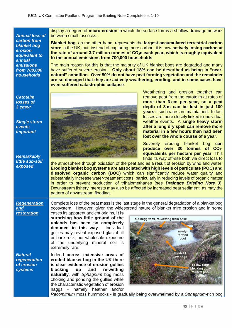
IUCN UK Committee Peatland Programme Briefing Note Complete set 1-10 1 | Page IUCN UK Committee Peatland Programme Briefing Note N o 1 Peat Bog Ecosystems: Key Definitions What are bogs? Rainfall-fed wetland systems Water-logging prevents decomposition Peat formation Mire Peat soils may be intensively farmed with no mire vege- tation, but still remain peatlands Primary bog Secondary bog Bogs are particular types of wetlands which are waterlogged only by direct rainfall. This contrasts with fens where groundwater, enriched by the chemistry of mineral soils, causes waterlogging. Fens are more widespread in the UK lowlands and are thus more familiar to many people, but are often mistakenly referred to as ‘bogs’, despite being fed by groundwater. The water entering a bog contains only those nutrients found in rainfall, which is slightly acidic and almost devoid of nutrients. Water-logging in both bogs and fens prevents the complete decomposition of dead plant material. This un-decomposed plant material steadily accumulates as a thickness of peat, the presence of which is the defining feature of a peatland. Peat is thus a relatively amorphous organic deposit which consists of semi-decomposed plant material mixed with varying amounts of mineral, or inorganic, matter. In the case of UK peat bogs the content of mineral matter may be as low as 2% by weight, whereas fen peat generally has higher mineral-matter contents because such peat is waterlogged by mineral-enriched groundwater. The internationally-recognised term for a peat-forming system is a mire. It is not generally possible, however, to determine whether or not a peatland is actually forming peat at the present time. Consequently the EU Habitats Directive defines 'active' bog as a system which supports a significant area of vegetation which is normally peat forming because the presence of such vegetation is readily determined. The term 'active' bog also incorporates bogs which have suffered a temporary setback such as fire damage or drought, and also includes areas which have been damaged but which are now showing significant signs of active recovery, such as eroded bog in which the gullies are re-vegetating. It is nevertheless possible to have a peat soil from which the peat-forming vegetation has been completely removed or replaced, most commonly by human action. In such cases the system is no longer an actively peat-forming mire, but it remains a peatland because it still possesses a peat soil even though the present vegetation is not capable of forming peat. This is the most widespread condition for peat soils in the UK lowlands because many such peatlands are now intensively farmed as arable cropland or grass pasture. Other lowland peat sites have had their surface vegetation removed to facilitate the extraction of peat for horticultural use. In the uplands, extensive parts of the landscape are similarly peatlands which are no longer peat-forming, in this case because past atmospheric pollution, drainage, afforestation, burning and overgrazing have removed the key peat-forming species from the vegetation. In the case of a peatland, the surface vegetation is just one part of the whole ecosystem. The body of peat beneath the vegetation provides the other key component. An important distinction therefore also exists between a primary bog surface, where the surface and peat beneath have been created by natural peat accumulation, and a secondary bog surface, where peat had been removed by human action to create an artificial morphology.
Transcript
IUCN UK Committee Peatland Programme Briefing Note Complete set 1-10
1 | P a g e
IUCN UK Committee Peatland Programme BriBr Briefing Note No1
Peat Bog Ecosystems: Key Definitions
What are bogs? Rainfall-fed wetland systems Water-logging prevents decomposition Peat formation Mire Peat soils may be intensively farmed with no mire vege-tation, but still remain peatlands Primary bog Secondary bog
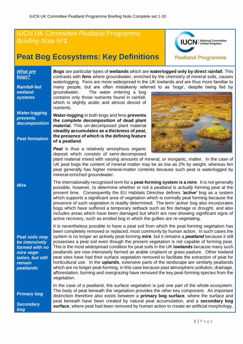
Bogs are particular types of wetlands which are waterlogged only by direct rainfall. This contrasts with fens where groundwater, enriched by the chemistry of mineral soils, causes waterlogging. Fens are more widespread in the UK lowlands and are thus more familiar to many people, but are often mistakenly referred to as ‘bogs’, despite being fed by groundwater. The water entering a bog contains only those nutrients found in rainfall, which is slightly acidic and almost devoid of nutrients.
Water-logging in both bogs and fens prevents the complete decomposition of dead plant material. This un-decomposed plant material steadily accumulates as a thickness of peat, the presence of which is the defining feature of a peatland.
Peat is thus a relatively amorphous organic deposit which consists of semi-decomposed plant material mixed with varying amounts of mineral, or inorganic, matter. In the case of UK peat bogs the content of mineral matter may be as low as 2% by weight, whereas fen peat generally has higher mineral-matter contents because such peat is waterlogged by mineral-enriched groundwater.
The internationally-recognised term for a peat-forming system is a mire. It is not generally possible, however, to determine whether or not a peatland is actually forming peat at the present time. Consequently the EU Habitats Directive defines 'active' bog as a system which supports a significant area of vegetation which is normally peat forming because the presence of such vegetation is readily determined. The term 'active' bog also incorporates bogs which have suffered a temporary setback such as fire damage or drought, and also includes areas which have been damaged but which are now showing significant signs of active recovery, such as eroded bog in which the gullies are re-vegetating.
It is nevertheless possible to have a peat soil from which the peat-forming vegetation has been completely removed or replaced, most commonly by human action. In such cases the system is no longer an actively peat-forming mire, but it remains a peatland because it still possesses a peat soil even though the present vegetation is not capable of forming peat. This is the most widespread condition for peat soils in the UK lowlands because many such peatlands are now intensively farmed as arable cropland or grass pasture. Other lowland peat sites have had their surface vegetation removed to facilitate the extraction of peat for horticultural use. In the uplands, extensive parts of the landscape are similarly peatlands which are no longer peat-forming, in this case because past atmospheric pollution, drainage, afforestation, burning and overgrazing have removed the key peat-forming species from the vegetation.
In the case of a peatland, the surface vegetation is just one part of the whole ecosystem. The body of peat beneath the vegetation provides the other key component. An important distinction therefore also exists between a primary bog surface, where the surface and peat beneath have been created by natural peat accumulation, and a secondary bog surface, where peat had been removed by human action to create an artificial morphology.
IUCN UK Committee Peatland Programme Briefing Note Complete set 1-10
2 | P a g e
A key distinction between primary and secondary surfaces is that, where a primary surface is retained, the overall shape of the bog together with its entire peat archive remains largely intact, whereas in creating a secondary surface the shape of the bog becomes markedly artificial and part of the archive is removed. Such secondary surfaces are generally created by agricultural land-claim, peat cutting or open-cast mining. Perhaps surprisingly, drainage and even forestry may still retain a primary surface even though subsidence may result in significant changes to the morphology of the bog (see Drainage Briefing Note 3). Consequently restoration of a stable bog hydrology after drainage or forestry may be somewhat easier and (ultimately) more complete than is the case for the complex morphologies and truncated peat archives of secondary surfaces.
History of peatland development
Macrofossils Microfossils
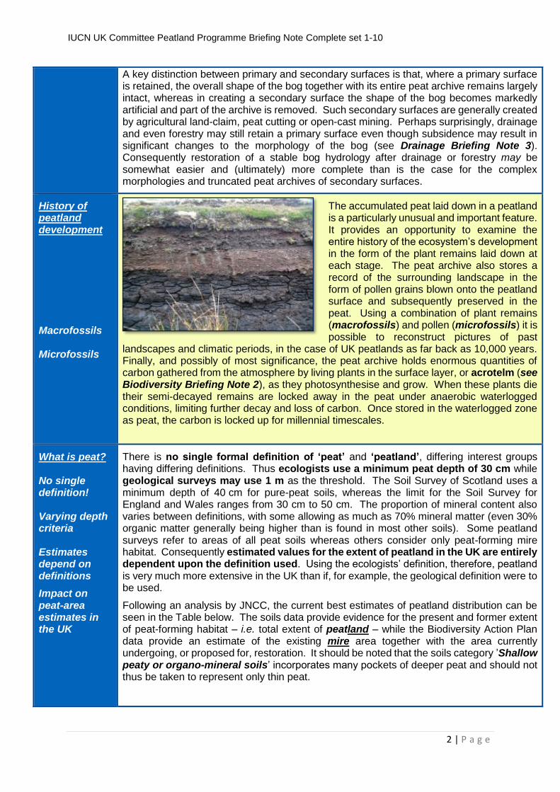
The accumulated peat laid down in a peatland is a particularly unusual and important feature. It provides an opportunity to examine the entire history of the ecosystem’s development in the form of the plant remains laid down at each stage. The peat archive also stores a record of the surrounding landscape in the form of pollen grains blown onto the peatland surface and subsequently preserved in the peat. Using a combination of plant remains (macrofossils) and pollen (microfossils) it is possible to reconstruct pictures of past
landscapes and climatic periods, in the case of UK peatlands as far back as 10,000 years. Finally, and possibly of most significance, the peat archive holds enormous quantities of carbon gathered from the atmosphere by living plants in the surface layer, or acrotelm (see Biodiversity Briefing Note 2), as they photosynthesise and grow. When these plants die their semi-decayed remains are locked away in the peat under anaerobic waterlogged conditions, limiting further decay and loss of carbon. Once stored in the waterlogged zone as peat, the carbon is locked up for millennial timescales.
What is peat? No single definition! Varying depth criteria Estimates depend on definitions
Impact on peat-area estimates in the UK
There is no single formal definition of ‘peat’ and ‘peatland’, differing interest groups having differing definitions. Thus ecologists use a minimum peat depth of 30 cm while geological surveys may use 1 m as the threshold. The Soil Survey of Scotland uses a minimum depth of 40 cm for pure-peat soils, whereas the limit for the Soil Survey for England and Wales ranges from 30 cm to 50 cm. The proportion of mineral content also varies between definitions, with some allowing as much as 70% mineral matter (even 30% organic matter generally being higher than is found in most other soils). Some peatland surveys refer to areas of all peat soils whereas others consider only peat-forming mire habitat. Consequently estimated values for the extent of peatland in the UK are entirely dependent upon the definition used. Using the ecologists’ definition, therefore, peatland is very much more extensive in the UK than if, for example, the geological definition were to be used.
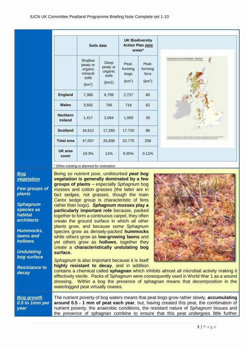
Following an analysis by JNCC, the current best estimates of peatland distribution can be seen in the Table below. The soils data provide evidence for the present and former extent of peat-forming habitat – i.e. total extent of peatland – while the Biodiversity Action Plan data provide an estimate of the existing mire area together with the area currently undergoing, or proposed for, restoration. It should be noted that the soils category ’Shallow peaty or organo-mineral soils’ incorporates many pockets of deeper peat and should not thus be taken to represent only thin peat.
IUCN UK Committee Peatland Programme Briefing Note Complete set 1-10
3 | P a g e
Soils data
UK Biodiversity
Action Plan mire
areas*
Shallow peaty or organo mineral
soils
(km2)
Deep peaty or organic
soils
(km2)
Peat-
forming
bogs
(km2)
Peat-
forming
fens
(km2)
England 7,386 6,799 2,727 80
Wales 3,592 706 718 62
Northern
Ireland 1,417 2,064 1,069 30
Scotland 34,612 17,269 17,720 86
Total area 47,007 26,838 22,775 258
UK area
cover 19.3% 11% 9.35% 0.11%
* Either existing or planned for restoration
Bog vegetation
Few groups of plants Sphagnum species as habitat architects Hummocks, lawns and hollows Undulating bog surface Resistance to decay
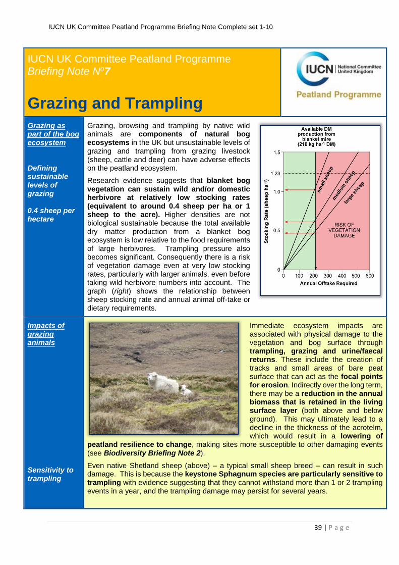
Being so nutrient poor, undisturbed peat bog vegetation is generally dominated by a few groups of plants – especially Sphagnum bog mosses and cotton grasses (the latter are in fact sedges, not grasses, though the main Carex sedge group is characteristic of fens rather than bogs). Sphagnum mosses play a particularly important role because, packed together to form a continuous carpet, they often create the ground surface in which all other plants grow, and because some Sphagnum species grow as densely-packed hummocks while others grow as low-growing lawns and yet others grow as hollows, together they create a characteristically undulating bog surface.
Sphagnum is also important because it is itself highly resistant to decay, and in addition contains a chemical called sphagnan which inhibits almost all microbial activity making it effectively sterile. Packs of Sphagnum were consequently used in World War 1 as a wound dressing. Within a bog the presence of sphagnan means that decomposition in the waterlogged peat virtually ceases.
Bog growth 0.5 to 1mm per year
The nutrient poverty of bog waters means that peat bogs grow rather slowly, accumulating around 0.5 - 1 mm of peat each year, but, having created this peat, the combination of nutrient poverty, the anaerobic conditions, the resistant nature of Sphagnum tissues and the presence of sphagnan combine to ensure that this peat undergoes little further
IUCN UK Committee Peatland Programme Briefing Note Complete set 1-10
4 | P a g e
Raised bog Blanket bog
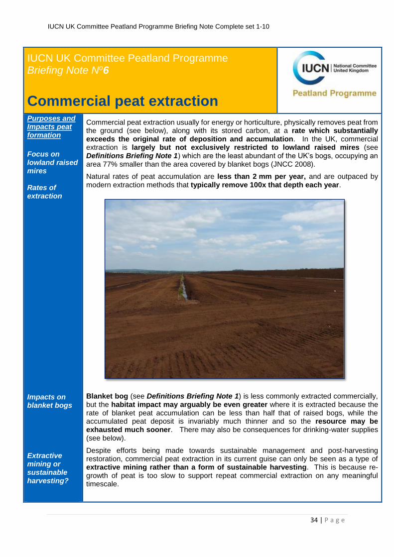
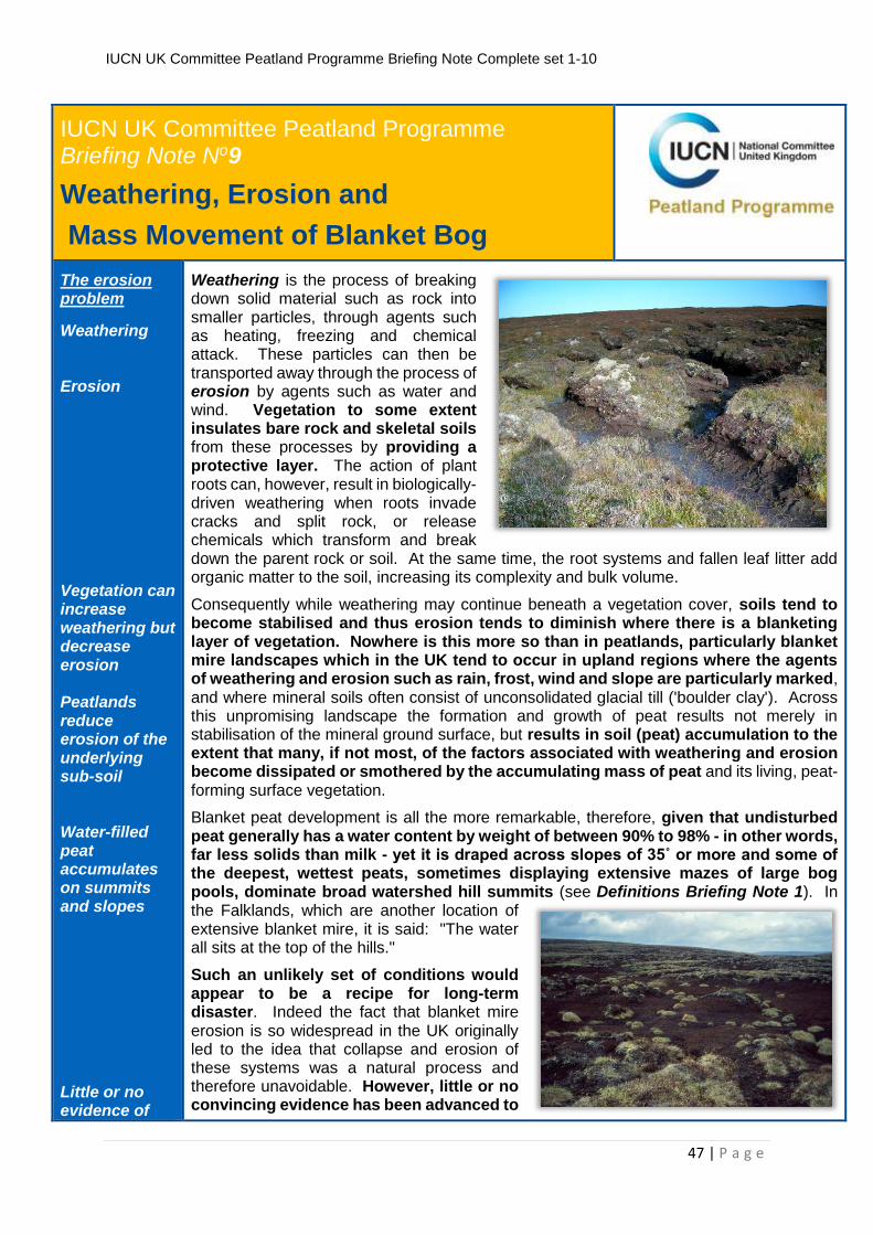
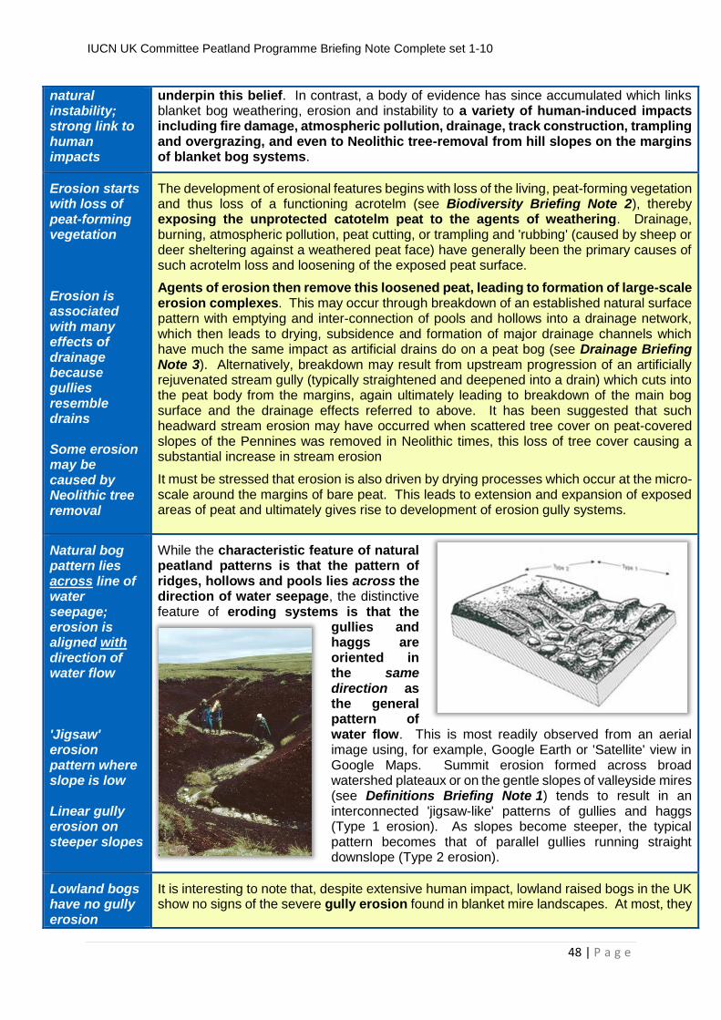
decomposition. As a result, many areas of UK peat bog have been accumulating these small increments for as much as 10,000 years, and have consequently generated peat depths of up to 10 m. Such depths are typical of raised bogs which occur as isolated peatlands in the UK lowlands, with examples recorded as far south as the Kent coast. In the UK uplands, however, where the climate is generally wetter, peat has come to smother entire landscapes in what is termed, appropriately, blanket bog, and although the peat is more extensive than in the lowlands it is also generally thinner, with an average maximum depth of 6 m, partly because much blanket bog has been forming for a shorter period of time (often 5-6,000 years) and also because the sloping nature of much ground prevents effective water-logging and results in greater nutrient through-flow. In the wettest parts of upland Britain, slopes of up to 40° may still have some peat formation, albeit rather shallow, whereas in drier regions even quite modest slopes may be sufficient to restrict peat formation to a thin organic layer or even prevent its formation altogether. As a result, the very extensive blanket bog landscapes of the UK uplands consist of a peat mantle which varies substantially in thickness from a few centimetres to several metres, and such variation may sometimes be found over distances of less than 50-100 m.
Classifying bog landscapes Inter-connected mosaic of individual peatland units UK classification compares poorly with other European countries
Blanket mire landscapes (below) consist of an inter-connected mosaic of individual peatland units, mostly bogs but also some fen systems, which are each characterised by their topographic position and morphology. These characteristics reveal much about
the functioning of each unit and are thus important as a means of identifying the part played by each unit within the overall blanket mire landscape. Although many peat-rich western nations such as Sweden recognise and describe these peatland units as a standard process, the UK does not. Consequently most of the UK blanket bog landscape is described only in terms of rather broad vegetation types, which ultimately results in poor understanding of key site features and condition (see Biodiversity Briefing Note 2, and Briefing Notes 3, 5, 7, 8, 9).
Mire units characterised on basis of position in landscape, shape, and hydrology
As a minimum, the individual peatland units of a peat-dominated landscape should be separated from true heaths and upland grasslands by the presence of thin organic soils in these latter types. The individual mire units should then be identified and characterised on the basis of their position in the landscape and their shape, as well as their overall hydrology. The first two features are reasonably straightforward but the third is critical because it helps to separate bog units fed only by direct rainfall from fens receiving water from the surrounding catchment.
IUCN UK Committee Peatland Programme Briefing Note Complete set 1-10
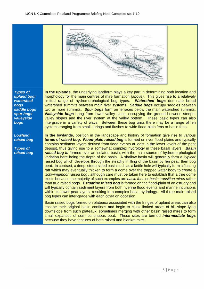
In the uplands, the underlying landform plays a key part in determining both location and morphology for the main centres of mire formation (above). This gives rise to a relatively limited range of hydromorphological bog types. Watershed bogs dominate broad watershed summits between main river systems. Saddle bogs occupy saddles between two or more summits. Spur bogs form on terraces below the main watershed summits. Valleyside bogs hang from lower valley sides, occupying the ground between steeper valley slopes and the river system at the valley bottom. These basic types can also intergrade in a variety of ways. Between these bog units there may be a range of fen systems ranging from small springs and flushes to wide flood-plain fens or basin fens.
Lowland raised bog Types of raised bog
In the lowlands, position in the landscape and history of formation give rise to various forms of raised bog. Flood-plain raised bog is formed on river flood-plains and typically contains sediment layers derived from flood events at least in the lower levels of the peat deposit, thus giving rise to a somewhat complex hydrology in these basal layers. Basin raised bog is formed over an isolated basin, with the main source of hydromorphological variation here being the depth of the basin. A shallow basin will generally form a 'typical' raised bog which develops through the steadily infilling of the basin by fen peat, then bog peat. In contrast, a deep, steep-sided basin such as a kettle hole will typically form a floating raft which may eventually thicken to form a dome over the trapped water body to create a 'schwimgmoor raised bog', although care must be taken here to establish that a true dome exists because the majority of such examples are basin fens or basin transition mires rather than true raised bogs. Estuarine raised bog is formed on the flood-plain of an estuary and will typically contain sediment layers from both riverine flood events and marine incursions within its lower peat layers, resulting in a complex basal hydrology. All three main raised bog types can inter-grade with each other on occasion.
Basin raised bogs formed on plateaux associated with the fringes of upland areas can also escape their original basin confines and begin to cloak limited areas of hill slope lying downslope from such plateaux, sometimes merging with other basin raised mires to form small expanses of semi-continuous peat. These sites are termed intermediate bogs because they have features of both raised and blanket mire..
IUCN UK Committee Peatland Programme Briefing Note Complete set 1-10
6 | P a g e
Hydrology
Mapping of 'flow lines'
Bogs shed water; fens receive water
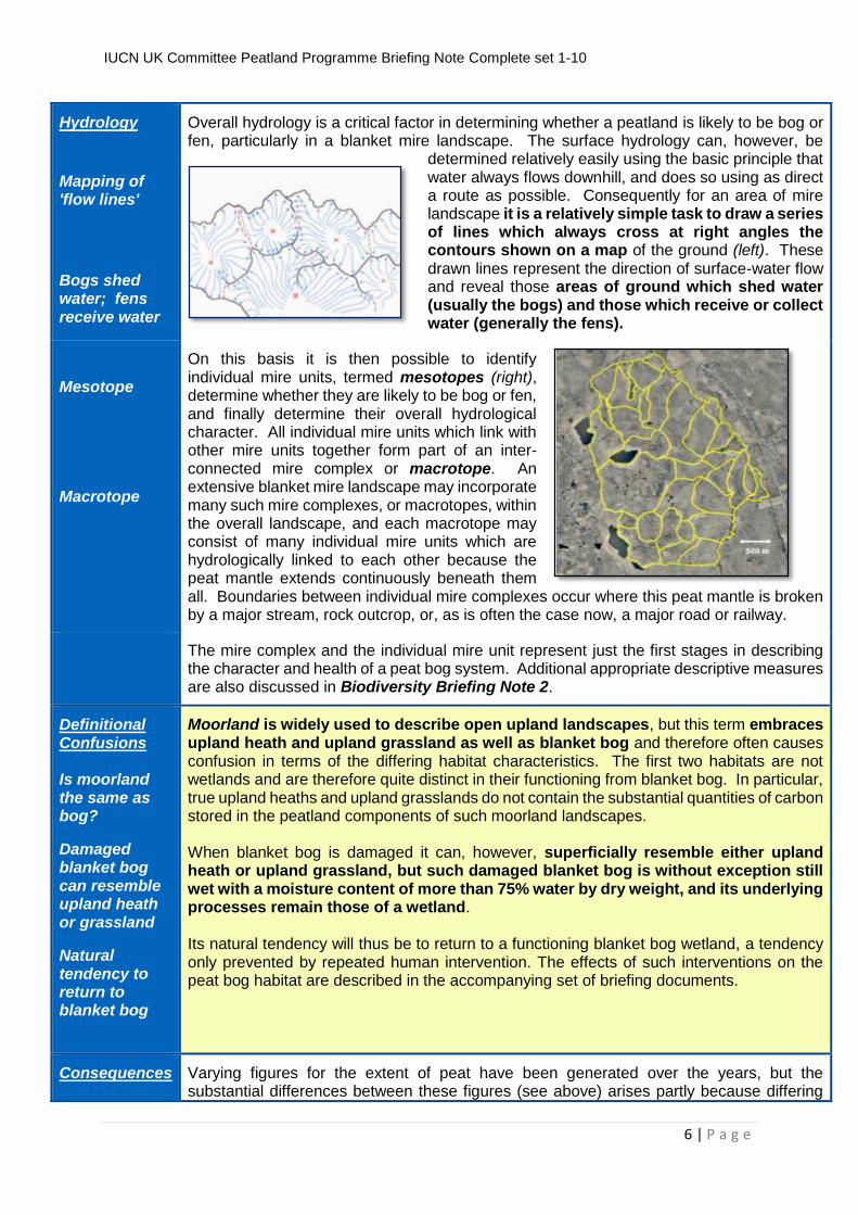
Overall hydrology is a critical factor in determining whether a peatland is likely to be bog or fen, particularly in a blanket mire landscape. The surface hydrology can, however, be
determined relatively easily using the basic principle that water always flows downhill, and does so using as direct a route as possible. Consequently for an area of mire landscape it is a relatively simple task to draw a series of lines which always cross at right angles the contours shown on a map of the ground (left). These drawn lines represent the direction of surface-water flow and reveal those areas of ground which shed water (usually the bogs) and those which receive or collect water (generally the fens).
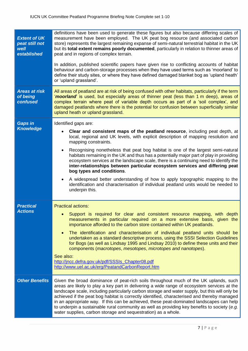
Mesotope Macrotope
On this basis it is then possible to identify individual mire units, termed mesotopes (right), determine whether they are likely to be bog or fen, and finally determine their overall hydrological character. All individual mire units which link with other mire units together form part of an inter-connected mire complex or macrotope. An extensive blanket mire landscape may incorporate many such mire complexes, or macrotopes, within the overall landscape, and each macrotope may consist of many individual mire units which are hydrologically linked to each other because the peat mantle extends continuously beneath them all. Boundaries between individual mire complexes occur where this peat mantle is broken by a major stream, rock outcrop, or, as is often the case now, a major road or railway.
The mire complex and the individual mire unit represent just the first stages in describing the character and health of a peat bog system. Additional appropriate descriptive measures are also discussed in Biodiversity Briefing Note 2.
Definitional Confusions Is moorland the same as bog?
Damaged blanket bog can resemble upland heath or grassland
Natural tendency to return to blanket bog
Moorland is widely used to describe open upland landscapes, but this term embraces upland heath and upland grassland as well as blanket bog and therefore often causes confusion in terms of the differing habitat characteristics. The first two habitats are not wetlands and are therefore quite distinct in their functioning from blanket bog. In particular, true upland heaths and upland grasslands do not contain the substantial quantities of carbon stored in the peatland components of such moorland landscapes. When blanket bog is damaged it can, however, superficially resemble either upland heath or upland grassland, but such damaged blanket bog is without exception still wet with a moisture content of more than 75% water by dry weight, and its underlying processes remain those of a wetland. Its natural tendency will thus be to return to a functioning blanket bog wetland, a tendency only prevented by repeated human intervention. The effects of such interventions on the peat bog habitat are described in the accompanying set of briefing documents.
Consequences
Varying figures for the extent of peat have been generated over the years, but the substantial differences between these figures (see above) arises partly because differing
IUCN UK Committee Peatland Programme Briefing Note Complete set 1-10
7 | P a g e
Extent of UK peat still not well established
definitions have been used to generate these figures but also because differing scales of measurement have been employed. The UK peat bog resource (and associated carbon store) represents the largest remaining expanse of semi-natural terrestrial habitat in the UK but its total extent remains poorly documented, particularly in relation to thinner areas of peat and in regions of complex terrain. In addition, published scientific papers have given rise to conflicting accounts of habitat behaviour and carbon-storage processes when they have used terms such as ‘moorland’ to define their study sites, or where they have defined damaged blanket bog as ‘upland heath’ or ‘upland grassland’.
Areas at risk of being confused
All areas of peatland are at risk of being confused with other habitats, particularly if the term ‘moorland’ is used, but especially areas of thinner peat (less than 1 m deep), areas of complex terrain where peat of variable depth occurs as part of a ‘soil complex’, and damaged peatlands where there is the potential for confusion between superficially similar upland heath or upland grassland.
Gaps in Knowledge
Identified gaps are:
Clear and consistent maps of the peatland resource, including peat depth, at local, regional and UK levels, with explicit description of mapping resolution and mapping constraints.
Recognising nonetheless that peat bog habitat is one of the largest semi-natural habitats remaining in the UK and thus has a potentially major part of play in providing ecosystem services at the landscape scale, there is a continuing need to identify the inter-relationships between particular ecosystem services and differing peat bog types and conditions.
A widespread better understanding of how to apply topographic mapping to the identification and characterisation of individual peatland units would be needed to underpin this.
Practical Actions
Practical actions:
Support is required for clear and consistent resource mapping, with depth measurements in particular required on a more extensive basis, given the importance afforded to the carbon store contained within UK peatlands.
The identification and characterisation of individual peatland units should be undertaken as a standard descriptive process, using the SSSI Selection Guidelines for Bogs (as well as Lindsay 1995 and Lindsay 2010) to define these units and their components (macrotopes, mesotopes, microtopes and nanotopes).
See also: http://jncc.defra.gov.uk/pdf/SSSIs_Chapter08.pdf http://www.uel.ac.uk/erg/PeatandCarbonReport.htm
Other Benefits
Given the broad dominance of peat-rich soils throughout much of the UK uplands, such areas are likely to play a key part in delivering a wide range of ecosystem services at the landscape scale, including particularly carbon storage and water supply, but this will only be achieved if the peat bog habitat is correctly identified, characterised and thereby managed in an appropriate way. If this can be achieved, these peat-dominated landscapes can help to underpin a sustainable rural community as well as providing key benefits to society (e.g. water supplies, carbon storage and sequestration) as a whole.
IUCN UK Committee Peatland Programme Briefing Note Complete set 1-10
8 | P a g e
More Information
Underpinning scientific report: http://www.rspb.org.uk/Images/Peatbogs_and_carbon_tcm9-255200.pdf (low resolution) http://www.uel.ac.uk/erg/PeatandCarbonReport.htm (high resolution : downloadable in sections) IUCN UK Peatland Programme: http://www.iucn-uk-peatlandprogramme.org/ Natural England Uplands Evidence Review: http://www.naturalengland.org.uk/ourwork/uplands/uplandsevidencereviewfeature.aspx Scottish Natural Heritage Report on peat definitions: http://www.snh.org.uk/pdfs/publications/commissioned_reports/701.pdf Peatland Action: http://www.snh.gov.uk/climate-change/what-snh-is-doing/peatland-action/
This briefing note is part of a series aimed at policy makers, practitioners and academics to help explain the ecological processes that underpin peatland function. Understanding the ecology of peatlands is essential when investigating the impacts of human activity on peatlands, interpreting research findings and planning the recovery of damaged peatlands.
These briefs have been produced following a major process of review and comment building on an original document: Lindsay, R. 2010 ‘Peatbogs and Carbon: a Critical Synthesis’ University of East London. published by RSPB, Sandy. http://www.rspb.org.uk/Images/Peatbogs_and_carbon_tcm9-255200.pdf
The full set of briefs can be downloaded from:www.iucn-uk-peatlandprogramme.org.uk
The International Union for the Conservation of Nature (IUCN) is a global organisation, providing an influential and authoritative voice for nature conservation. The IUCN UK Peatland Programme promotes peatland restoration in the UK and advocates the multiple benefits of peatlands through partnerships, strong science, sound policy and effective practice.
We are grateful to Scottish Natural Heritage, Natural England, Natural Resources Wales, the Forestry Commission RSPB Scotland and the Peter de Haan Charitable Trust for funding support.
Authors Date
Richard Lindsay, Richard Birnie, Jack Clough Version Date: 5th November 2014
IUCN UK Committee Peatland Programme Briefing Note Complete set 1-10
9 | P a g e
IUCN UK Committee Peatland Programme Briefing Note No 2
Peat Bog Ecosystems: Structure, Form, State and Condition
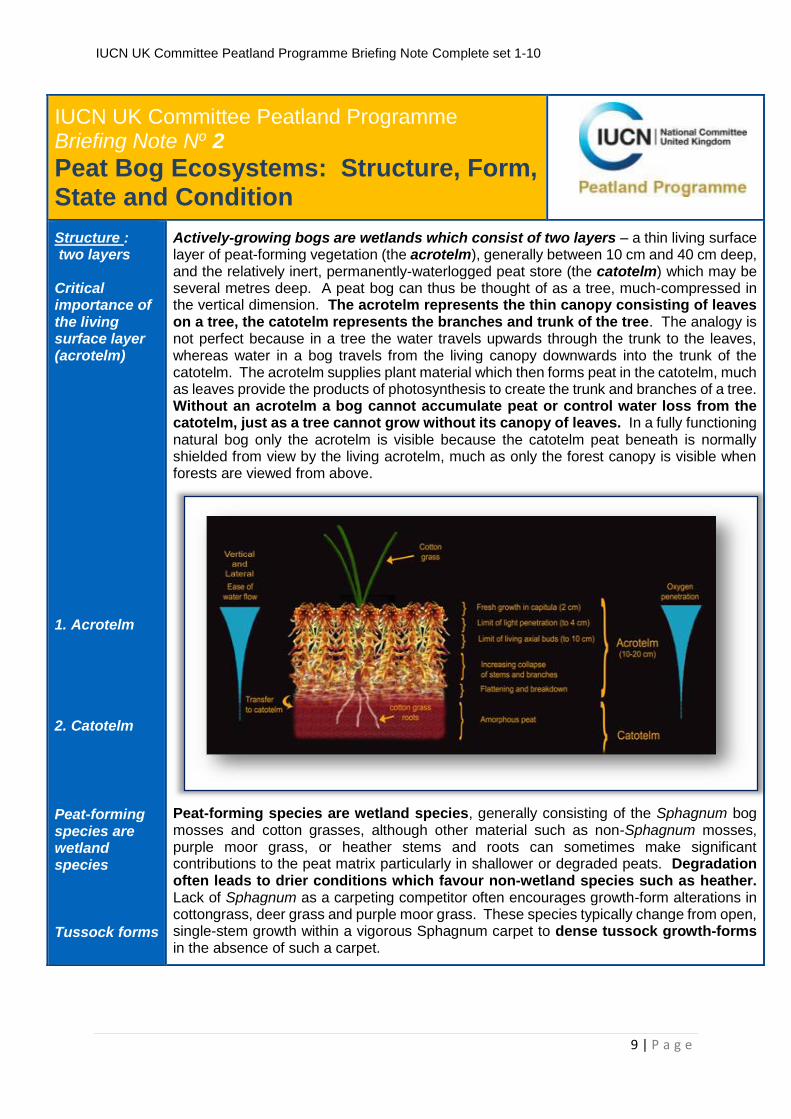
Structure : two layers Critical importance of the living surface layer (acrotelm) 1. Acrotelm 2. Catotelm
Peat-forming species are wetland species Tussock forms
Actively-growing bogs are wetlands which consist of two layers – a thin living surface layer of peat-forming vegetation (the acrotelm), generally between 10 cm and 40 cm deep, and the relatively inert, permanently-waterlogged peat store (the catotelm) which may be several metres deep. A peat bog can thus be thought of as a tree, much-compressed in the vertical dimension. The acrotelm represents the thin canopy consisting of leaves on a tree, the catotelm represents the branches and trunk of the tree. The analogy is not perfect because in a tree the water travels upwards through the trunk to the leaves, whereas water in a bog travels from the living canopy downwards into the trunk of the catotelm. The acrotelm supplies plant material which then forms peat in the catotelm, much as leaves provide the products of photosynthesis to create the trunk and branches of a tree. Without an acrotelm a bog cannot accumulate peat or control water loss from the catotelm, just as a tree cannot grow without its canopy of leaves. In a fully functioning natural bog only the acrotelm is visible because the catotelm peat beneath is normally shielded from view by the living acrotelm, much as only the forest canopy is visible when forests are viewed from above.
Peat-forming species are wetland species, generally consisting of the Sphagnum bog mosses and cotton grasses, although other material such as non-Sphagnum mosses, purple moor grass, or heather stems and roots can sometimes make significant contributions to the peat matrix particularly in shallower or degraded peats. Degradation often leads to drier conditions which favour non-wetland species such as heather. Lack of Sphagnum as a carpeting competitor often encourages growth-form alterations in cottongrass, deer grass and purple moor grass. These species typically change from open, single-stem growth within a vigorous Sphagnum carpet to dense tussock growth-forms in the absence of such a carpet.
IUCN UK Committee Peatland Programme Briefing Note Complete set 1-10
10 | P a g e
Mire form:
surface patterning Micro-topography
Narrow vertical vegetation zones Tierra del Fuego biodiversity based on two Sphagnum species
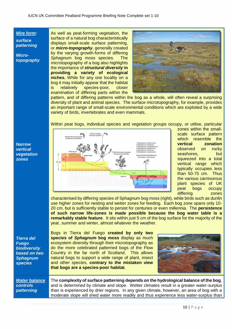
As well as peat-forming vegetation, the surface of a natural bog characteristically displays small-scale surface patterning, or micro-topography, generally created by the varying growth-forms of differing Sphagnum bog moss species. The microtopography of a bog also highlights the importance of structural diversity in providing a variety of ecological niches. While for any one locality on a bog it may initially appear that the habitat is relatively species-poor, closer examination of differing parts within the pattern, and of differing patterns within the bog as a whole, will often reveal a surprising diversity of plant and animal species. The surface microtopography, for example, provides an important range of small-scale environmental conditions which are exploited by a wide variety of birds, invertebrates and even mammals.
Within peat bogs, individual species and vegetation groups occupy, or utilise, particular zones within the small-scale surface pattern which resemble the vertical zonation observed on rocky seashores, but squeezed into a total vertical range which typically occupies less than 50-75 cm. Thus the various carnivorous plant species of UK peat bogs occupy differing zones
characterised by differing species of Sphagnum bog moss (right), while birds such as dunlin use higher zones for nesting and wetter zones for feeding. Each bog zone spans only 10-20 cm, but is sufficiently stable to persist for centuries or even millennia. The persistence of such narrow life-zones is made possible because the bog water table is a remarkably stable feature. It sits within just 5 cm of the bog surface for the majority of the year, summer and winter, almost whatever the weather. Bogs in Tierra del Fuego created by only two species of Sphagnum bog moss display as much ecosystem diversity through their microtopography as do the more celebrated patterned bogs of the Flow Country in the far north of Scotland. This allows natural bogs to support a wide range of plant, insect and other species, contrary to the mistaken view that bogs are a species-poor habitat.
Water balance controls patterning
The complexity of surface patterning depends on the hydrological balance of the bog, and is determined by climate and slope. Wetter climates result in a greater water-surplus than is experienced by drier regions. In any given climate, however, an area of bog with a moderate slope will shed water more readily and thus experience less water-surplus than
IUCN UK Committee Peatland Programme Briefing Note Complete set 1-10
11 | P a g e
Hollows and pools Ridges and hummocks Resilience to climate change Natural States:
Three typical states across the UK Different degrees of patterning in different places Natural states reflect different climatic conditions Equal levels of ecosystem function
does a bog surface which is almost level. Significant quantities of surplus water are stored as hollows or pools, and the greater the quantity of available surplus water, the larger and more complex these pool systems will be. Furthermore, during wet phases in the climate there will be a tendency for greater hollow and pool formation whereas during dry phases bogs will become dominated by mossy ridges and hummocks at the expense of hollows and pools. This adaptive response has allowed UK bogs to lay down peat almost continuously throughout the past 10,000 years despite several major shifts in climate during this period. Bogs in their natural state are remarkably resilient wetland systems.
Describing Bogs: vegetation is not enough!
JNCC '-tope' system
Thus vegetation describes only one facet of diversity in peat bogs, yet, among western nations with substantial peat deposits, the UK is one of the few not to use an integrated system of vegetation, microtopography and overall site hydrology to characterise the biodiversity of its bog systems. Instead it relies almost exclusively on vegetation description, most commonly in the form of the National Vegetation Classification (NVC), despite the fact that an integrated system has been recommended for use by the statutory conservation agencies (now through the Joint Nature Conservation Committee – JNCC) for the past two decades.
This JNCC “-tope” system (macrotope, mesotope, microtope, nanotope), which is set out in the SSSI Selection Guidelines for Bogs, provides a hierarchical system of description, modelled on systems employed by other peat-rich nations such as Sweden, Finland, Canada, Norway and Russia, for describing vegetation, microtopography, whole peatland units and interlinked peatland complexes. Integrated links to the NVC are also provided in the SSSI Selection Guidelines because the NVC offers a valuable set of vegetation
IUCN UK Committee Peatland Programme Briefing Note Complete set 1-10
12 | P a g e
categories which work well at regional level. The system of description is further supplemented, amplified and illustrated by Lindsay (2010). Within the UK, this system has just begun to feature in a few large-scale survey programmes and research publications.
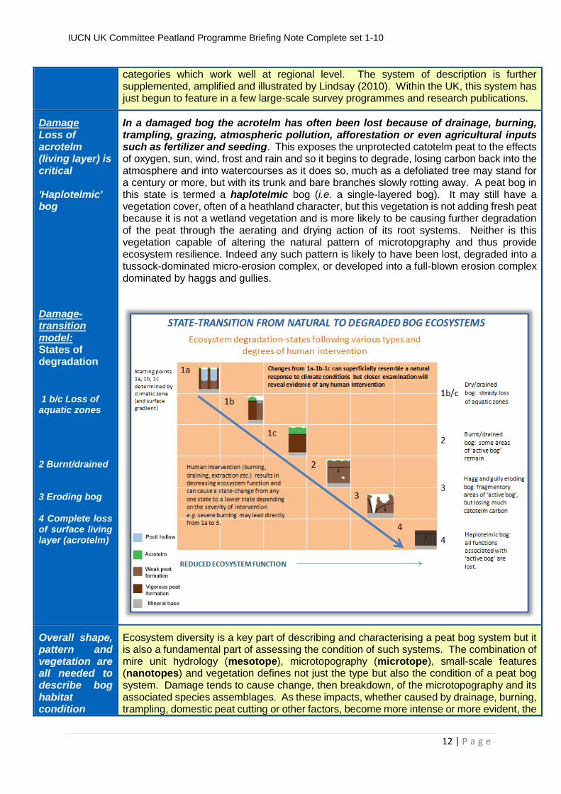
Damage Loss of acrotelm (living layer) is critical 'Haplotelmic' bog Damage-transition model: States of degradation
1 b/c Loss of aquatic zones 2 Burnt/drained 3 Eroding bog 4 Complete loss of surface living layer (acrotelm)
In a damaged bog the acrotelm has often been lost because of drainage, burning, trampling, grazing, atmospheric pollution, afforestation or even agricultural inputs such as fertilizer and seeding. This exposes the unprotected catotelm peat to the effects of oxygen, sun, wind, frost and rain and so it begins to degrade, losing carbon back into the atmosphere and into watercourses as it does so, much as a defoliated tree may stand for a century or more, but with its trunk and bare branches slowly rotting away. A peat bog in this state is termed a haplotelmic bog (i.e. a single-layered bog). It may still have a vegetation cover, often of a heathland character, but this vegetation is not adding fresh peat because it is not a wetland vegetation and is more likely to be causing further degradation of the peat through the aerating and drying action of its root systems. Neither is this vegetation capable of altering the natural pattern of microtopgraphy and thus provide ecosystem resilience. Indeed any such pattern is likely to have been lost, degraded into a tussock-dominated micro-erosion complex, or developed into a full-blown erosion complex dominated by haggs and gullies.
Overall shape, pattern and vegetation are all needed to describe bog habitat condition
Ecosystem diversity is a key part of describing and characterising a peat bog system but it is also a fundamental part of assessing the condition of such systems. The combination of mire unit hydrology (mesotope), microtopography (microtope), small-scale features (nanotopes) and vegetation defines not just the type but also the condition of a peat bog system. Damage tends to cause change, then breakdown, of the microtopography and its associated species assemblages. As these impacts, whether caused by drainage, burning, trampling, domestic peat cutting or other factors, become more intense or more evident, the
IUCN UK Committee Peatland Programme Briefing Note Complete set 1-10
13 | P a g e
Non-wetland species are a sign of damage The majority of UK bogs are damaged: (the default position for assessment)
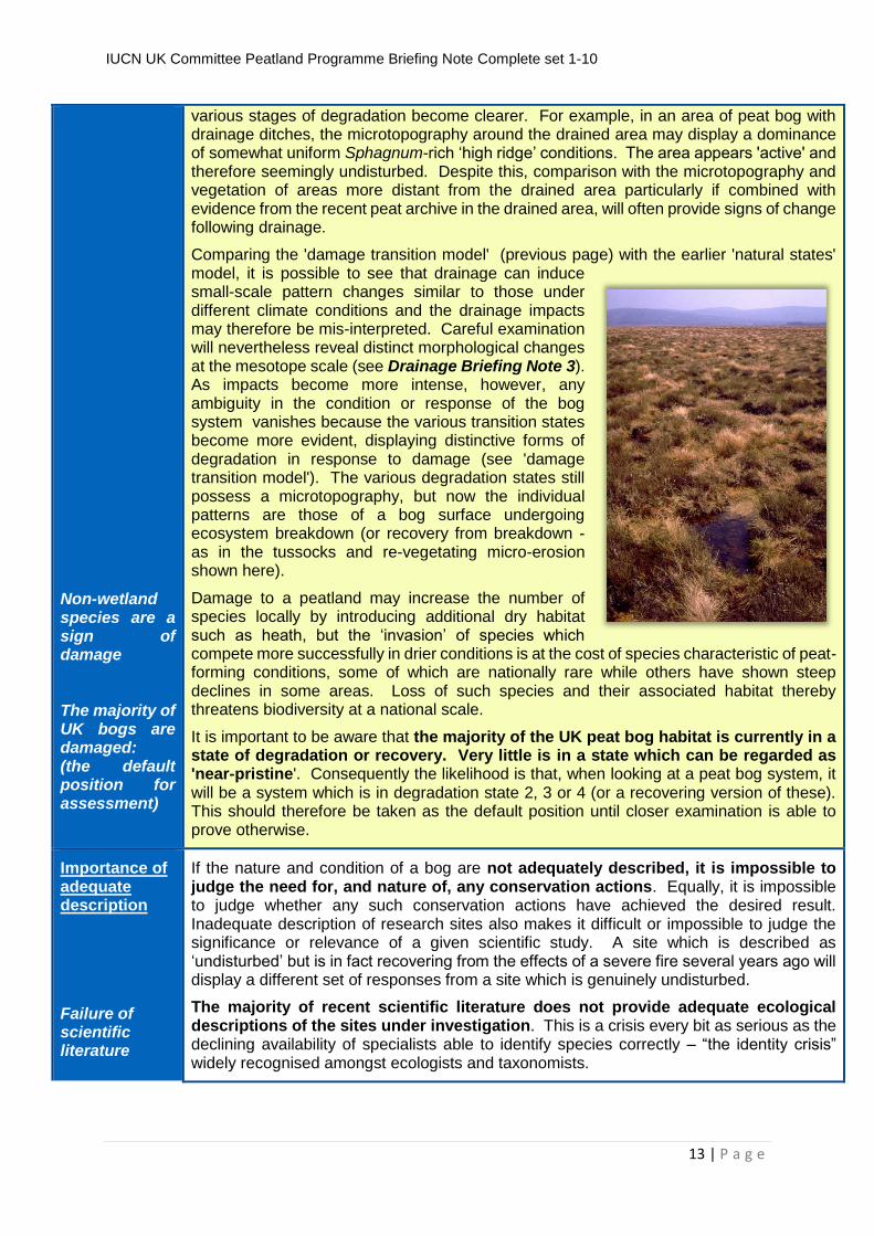
various stages of degradation become clearer. For example, in an area of peat bog with drainage ditches, the microtopography around the drained area may display a dominance of somewhat uniform Sphagnum-rich ‘high ridge’ conditions. The area appears 'active' and therefore seemingly undisturbed. Despite this, comparison with the microtopography and vegetation of areas more distant from the drained area particularly if combined with evidence from the recent peat archive in the drained area, will often provide signs of change following drainage.
Comparing the 'damage transition model' (previous page) with the earlier 'natural states' model, it is possible to see that drainage can induce small-scale pattern changes similar to those under different climate conditions and the drainage impacts may therefore be mis-interpreted. Careful examination will nevertheless reveal distinct morphological changes at the mesotope scale (see Drainage Briefing Note 3). As impacts become more intense, however, any ambiguity in the condition or response of the bog system vanishes because the various transition states become more evident, displaying distinctive forms of degradation in response to damage (see 'damage transition model'). The various degradation states still possess a microtopography, but now the individual patterns are those of a bog surface undergoing ecosystem breakdown (or recovery from breakdown - as in the tussocks and re-vegetating micro-erosion shown here).
Damage to a peatland may increase the number of species locally by introducing additional dry habitat such as heath, but the ‘invasion’ of species which compete more successfully in drier conditions is at the cost of species characteristic of peat-forming conditions, some of which are nationally rare while others have shown steep declines in some areas. Loss of such species and their associated habitat thereby threatens biodiversity at a national scale.
It is important to be aware that the majority of the UK peat bog habitat is currently in a state of degradation or recovery. Very little is in a state which can be regarded as 'near-pristine'. Consequently the likelihood is that, when looking at a peat bog system, it will be a system which is in degradation state 2, 3 or 4 (or a recovering version of these). This should therefore be taken as the default position until closer examination is able to prove otherwise.
Importance of adequate description
Failure of scientific literature
If the nature and condition of a bog are not adequately described, it is impossible to judge the need for, and nature of, any conservation actions. Equally, it is impossible to judge whether any such conservation actions have achieved the desired result. Inadequate description of research sites also makes it difficult or impossible to judge the significance or relevance of a given scientific study. A site which is described as ‘undisturbed’ but is in fact recovering from the effects of a severe fire several years ago will display a different set of responses from a site which is genuinely undisturbed.
The majority of recent scientific literature does not provide adequate ecological descriptions of the sites under investigation. This is a crisis every bit as serious as the declining availability of specialists able to identify species correctly – “the identity crisis” widely recognised amongst ecologists and taxonomists.
IUCN UK Committee Peatland Programme Briefing Note Complete set 1-10
14 | P a g e
Benefits of better descriptions
More effective descriptions of the peat bog ecosystem would improve correlations between ecosystem condition and the range of ecosystem behaviours noted within the scientific literature. It would also enable more accurate assessments of restoration requirements to be made, and would provide a framework of description for the monitoring of restoration effectiveness.
Areas at risk of being confused
Any area of upland, 'moorland' or lowland 'heath' has the potential to contain peatland soils and should therefore be checked for the presence of dark organic soil exceeding 30 cm in thickness, as should any area of wetland or agricultural land. There are even examples of peat soils in urban areas.
Gaps in Knowledge
Identified gaps are:
lack of descriptions of the full range of UK peat bog vegetation stands and their relationship with microtopography; the NVC provides high-level categories, the JNCC SSSI Guidelines for Bogs provide sub-categories linked to microtopography but the list is not geographically comprehensive;
adequate training for field surveyors to apply the 'tope' system.
Practical Actions
Practical actions:
adoption of the JNCC ‘tope' system is an urgent priority;
further development of the vegetation elements of the 'tope' system to provide good coverage of the geographical and ecological spectrum;
training for field surveyors in use of the 'tope' system.
See also: http://jncc.defra.gov.uk/pdf/SSSIs_Chapter08.pdf http://www.uel.ac.uk/erg/PeatandCarbonReport.htm
Other Benefits
By addressing the gaps and undertaking the practical actions listed above, the resulting system of peatland habitat description would enable all sectoral interests to develop a robust understanding of the current condition, future sustainable capacity, and scale of ecosystem services provided to society by the peatland resource.
More Information
Underpinning scientific report: http://www.rspb.org.uk/Images/Peatbogs_and_carbon_tcm9-255200.pdf (low resolution) http://www.uel.ac.uk/erg/PeatandCarbonReport.htm (high resolution : downloadable in sections) IUCN UK Peatland Programme: http://www.iucn-uk-peatlandprogramme.org/ Natural England Uplands Evidence Review: http://www.naturalengland.org.uk/ourwork/uplands/uplandsevidencereviewfeature.aspx Scottish Natural Heritage Report on peat definitions: http://www.snh.org.uk/pdfs/publications/commissioned_reports/701.pdf Peatland Action: http://www.snh.gov.uk/climate-change/what-snh-is-doing/peatland-action/
This briefing note is part of a series aimed at policy makers, practitioners and academics to help explain the ecological processes that underpin peatland function. Understanding the ecology of
IUCN UK Committee Peatland Programme Briefing Note Complete set 1-10
15 | P a g e
peatlands is essential when investigating the impacts of human activity on peatlands, interpreting research findings and planning the recovery of damaged peatlands.
These briefs have been produced following a major process of review and comment building on an original document: Lindsay, R. 2010 ‘Peatbogs and Carbon: a Critical Synthesis’ University of East London. published by RSPB, Sandy. http://www.rspb.org.uk/Images/Peatbogs_and_carbon_tcm9-
255200.pdf, this report also being available at high resolution and in sections from:
http://www.uel.ac.uk/erg/PeatandCarbonReport.htm
The full set of briefs can be downloaded from:www.iucn-uk-peatlandprogramme.org.uk
The International Union for the Conservation of Nature (IUCN) is a global organisation, providing an influential and authoritative voice for nature conservation. The IUCN UK Peatland Programme promotes peatland restoration in the UK and advocates the multiple benefits of peatlands through partnerships, strong science, sound policy and effective practice.
We are grateful to Scottish Natural Heritage, Natural England, Natural Resources Wales, the Forestry Commission RSPB Scotland and the Peter de Haan Charitable Trust for funding support.
Authors Date
Richard Lindsay, Richard Birnie, Jack Clough Version Date: 5th November 2014
IUCN UK Committee Peatland Programme Briefing Note Complete set 1-10
16 | P a g e
IUCN UK Committee Peatland Programme BriBr Briefing Note No3
Impacts of Artificial Drainage on Peatlands
Problem Wider impacts of drains are poorly recognised
Two common misconceptions are associated with artificial drainage of peat bogs. The first is that drainage impacts are largely confined to drain margins. In fact they can impact across a much wider area – in some cases, across the whole bog. The second misconception is that the bog water table should be the main focus of attention when studying the effect of drainage. Although it is important to measure the water table, the value of such data is much reduced if surface subsidence is not also measured. In the long term, surface subsidence rather than the water table is likely to show the greater drainage effect.
Impacts of Drainage Main impact of drainage is the re-shaping of the bog system Two-layered system, only one layer freely-draining
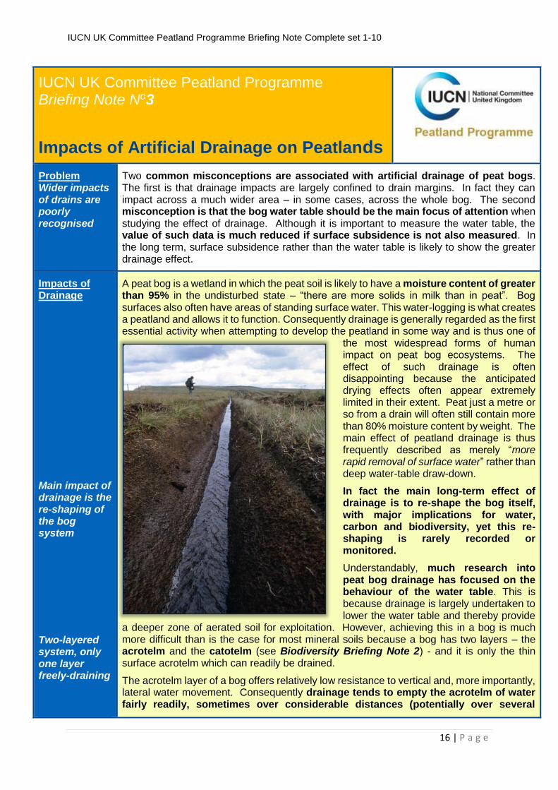
A peat bog is a wetland in which the peat soil is likely to have a moisture content of greater than 95% in the undisturbed state – “there are more solids in milk than in peat”. Bog surfaces also often have areas of standing surface water. This water-logging is what creates a peatland and allows it to function. Consequently drainage is generally regarded as the first essential activity when attempting to develop the peatland in some way and is thus one of
the most widespread forms of human impact on peat bog ecosystems. The effect of such drainage is often disappointing because the anticipated drying effects often appear extremely limited in their extent. Peat just a metre or so from a drain will often still contain more than 80% moisture content by weight. The main effect of peatland drainage is thus frequently described as merely “more rapid removal of surface water” rather than deep water-table draw-down.
In fact the main long-term effect of drainage is to re-shape the bog itself, with major implications for water, carbon and biodiversity, yet this re-shaping is rarely recorded or monitored.
Understandably, much research into peat bog drainage has focused on the behaviour of the water table. This is because drainage is largely undertaken to lower the water table and thereby provide
a deeper zone of aerated soil for exploitation. However, achieving this in a bog is much more difficult than is the case for most mineral soils because a bog has two layers – the acrotelm and the catotelm (see Biodiversity Briefing Note 2) - and it is only the thin surface acrotelm which can readily be drained.
The acrotelm layer of a bog offers relatively low resistance to vertical and, more importantly, lateral water movement. Consequently drainage tends to empty the acrotelm of water fairly readily, sometimes over considerable distances (potentially over several
IUCN UK Committee Peatland Programme Briefing Note Complete set 1-10
17 | P a g e
Drainage can affect the acrotelm over hundreds of metres
hundred metres). With an acrotelm thickness of only 10-20 cm, it is easy to understand, however, why such drainage effects are regarded as 'insignificant' and little more than removal of surface and near-surface water. From the perspective of the bog ecosystem, however, such effects represent a very significant impact. Peat-forming conditions exist because the high and relatively stable water table in the acrotelm maintains waterlogged conditions and enables bog species to resist competition from other plant species which are not normally peat forming.
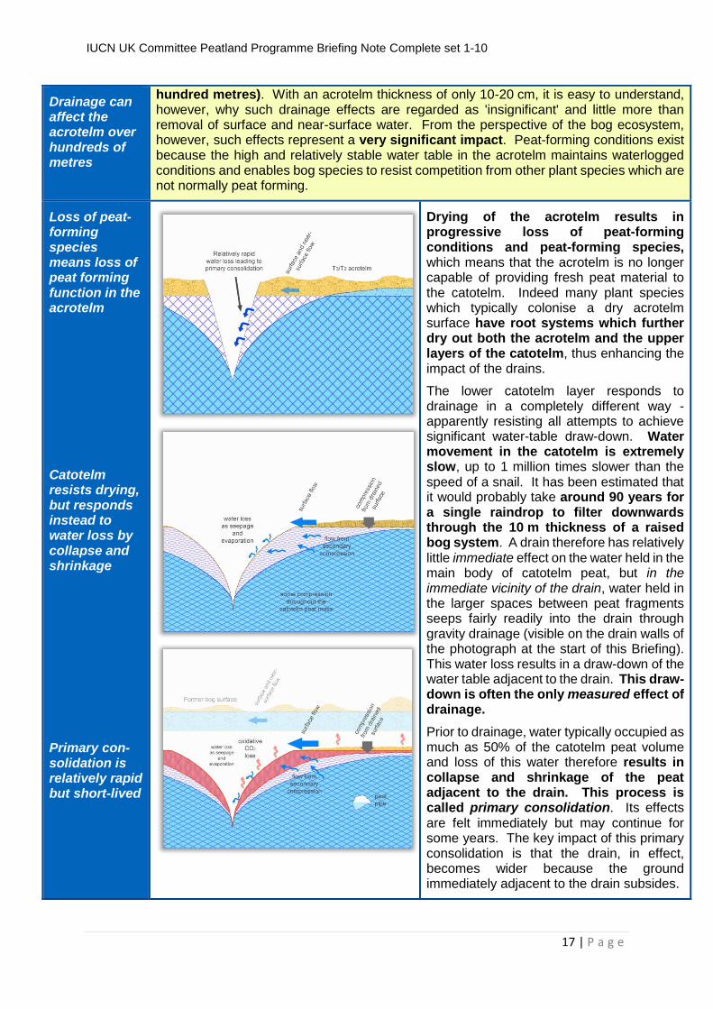
Loss of peat-forming species means loss of peat forming function in the acrotelm Catotelm resists drying, but responds instead to water loss by collapse and shrinkage Primary con-solidation is relatively rapid but short-lived
Drying of the acrotelm results in progressive loss of peat-forming conditions and peat-forming species, which means that the acrotelm is no longer capable of providing fresh peat material to the catotelm. Indeed many plant species which typically colonise a dry acrotelm surface have root systems which further dry out both the acrotelm and the upper layers of the catotelm, thus enhancing the impact of the drains.
The lower catotelm layer responds to drainage in a completely different way - apparently resisting all attempts to achieve significant water-table draw-down. Water movement in the catotelm is extremely slow, up to 1 million times slower than the speed of a snail. It has been estimated that it would probably take around 90 years for a single raindrop to filter downwards through the 10 m thickness of a raised bog system. A drain therefore has relatively little immediate effect on the water held in the main body of catotelm peat, but in the immediate vicinity of the drain, water held in the larger spaces between peat fragments seeps fairly readily into the drain through gravity drainage (visible on the drain walls of the photograph at the start of this Briefing). This water loss results in a draw-down of the water table adjacent to the drain. This draw-down is often the only measured effect of drainage.
Prior to drainage, water typically occupied as much as 50% of the catotelm peat volume and loss of this water therefore results in collapse and shrinkage of the peat adjacent to the drain. This process is called primary consolidation. Its effects are felt immediately but may continue for some years. The key impact of this primary consolidation is that the drain, in effect, becomes wider because the ground immediately adjacent to the drain subsides.
IUCN UK Committee Peatland Programme Briefing Note Complete set 1-10
18 | P a g e
Secondary compression
Oxidative wastage Secondary com-pression and oxidative wastage are long-term impacts Limited water-table draw-down does not mean limited drainage effects
This subsided, drained acrotelm and catotelm peat still has significant mass because somewhat more than 40% of its volume consists of water held in large storage spaces within the preserved plant fragments, most notably within leaves of Sphagnum bog moss. Consequently once the ‘free’ (or interstitial) water has been lost from the peat, the somewhat drier catotelm peat adjacent to the drain itself becomes a heavy load on the peat beneath because the drained layer no longer floats buoyantly within the bog water table. This load compresses the peat beneath it and squeezes more water from the peat into the drain, causing the bog surface to subside still further. Perhaps surprisingly, this downward pressure even forces water upwards into the drain from peat below – with the result that the entire depth of catotelm peat experiences some degree of subsidence. The effect is most marked in surface layers but can still be detected even at the base of the catotelm. This type of subsidence is called secondary compression. Secondary compression acts across a steadily widening area beyond the drain, demonstrably over several hundred metres in some cases, and continues as long as drainage is present.
The third catotelm process associated with drainage occurs because drainage allows oxygen to penetrate the catotelm. Under natural conditions the catotelm peat remains permanently waterlogged preventing oxygen-fuelled decomposition – and thus peat material is preserved for millennia. Once oxygen penetrates the catotelm peat store, relatively rapid decomposition can take place. Preserved plant material is thus lost in the form of carbon dioxide gas (CO2), leading to further subsidence as the peat material itself vanishes into the atmosphere. This process is called oxidative wastage.
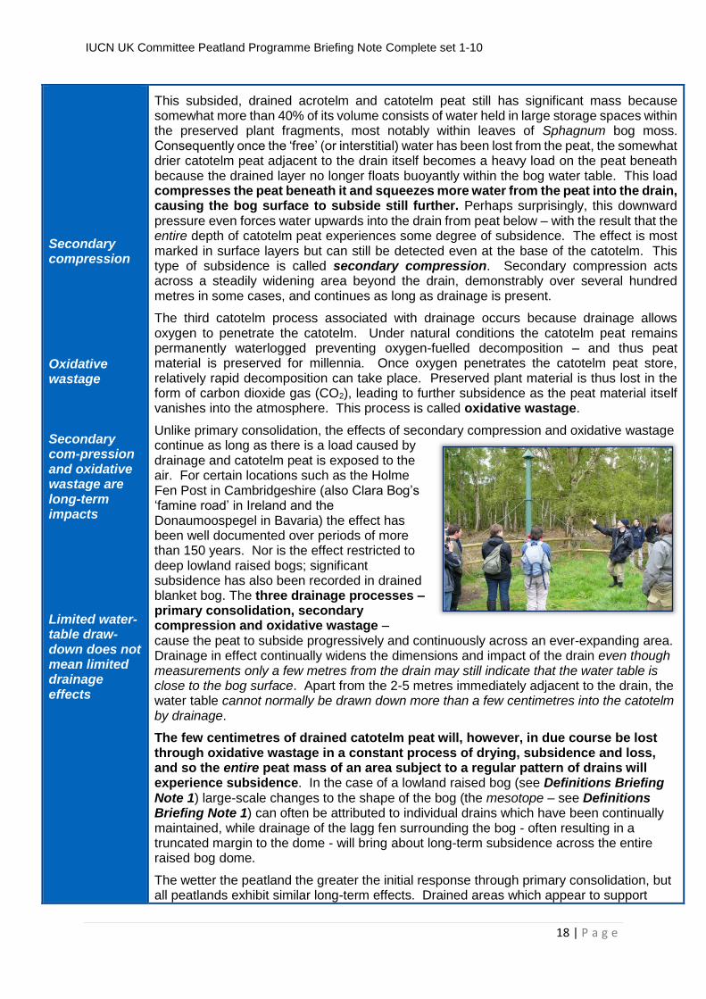
Unlike primary consolidation, the effects of secondary compression and oxidative wastage continue as long as there is a load caused by drainage and catotelm peat is exposed to the air. For certain locations such as the Holme Fen Post in Cambridgeshire (also Clara Bog’s ‘famine road’ in Ireland and the Donaumoospegel in Bavaria) the effect has been well documented over periods of more than 150 years. Nor is the effect restricted to deep lowland raised bogs; significant subsidence has also been recorded in drained blanket bog. The three drainage processes – primary consolidation, secondary compression and oxidative wastage – cause the peat to subside progressively and continuously across an ever-expanding area. Drainage in effect continually widens the dimensions and impact of the drain even though measurements only a few metres from the drain may still indicate that the water table is close to the bog surface. Apart from the 2-5 metres immediately adjacent to the drain, the water table cannot normally be drawn down more than a few centimetres into the catotelm by drainage.
The few centimetres of drained catotelm peat will, however, in due course be lost through oxidative wastage in a constant process of drying, subsidence and loss, and so the entire peat mass of an area subject to a regular pattern of drains will experience subsidence. In the case of a lowland raised bog (see Definitions Briefing Note 1) large-scale changes to the shape of the bog (the mesotope – see Definitions Briefing Note 1) can often be attributed to individual drains which have been continually maintained, while drainage of the lagg fen surrounding the bog - often resulting in a truncated margin to the dome - will bring about long-term subsidence across the entire raised bog dome.
The wetter the peatland the greater the initial response through primary consolidation, but all peatlands exhibit similar long-term effects. Drained areas which appear to support
IUCN UK Committee Peatland Programme Briefing Note Complete set 1-10
19 | P a g e
Shrinkage causes sub-surface pipe formation
vegetation unaffected by the drainage should be checked for evidence of past vegetation in the recent peat archive. Areas of deep peat with dense heather and areas rich in lichens or non-Sphagnum mosses are often indicators of vegetation change due to drainage.
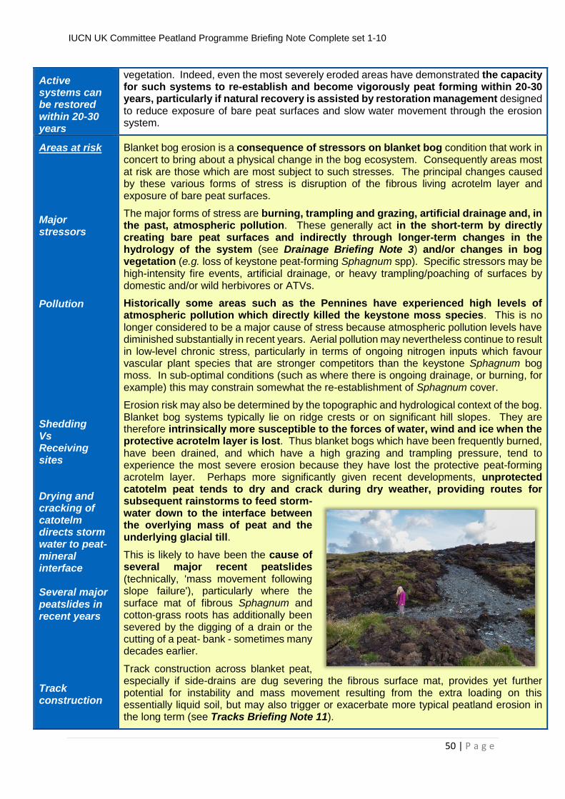
Shrinkage of the peat mass also causes it to deform in other ways. Like mud or clay when they dry, cracks may develop in the peat, particularly along the base of drains or parallel to the drains, and there is evidence to suggest that formation of sub-surface 'peat pipes' is more frequent in drained or drying peat.
If trees then colonise the drained peat, their roots will suck water from the peat and the canopy will prevent rainfall reaching the bog surface, while the weight of the trees further compresses the peat. This combination of effects results in even more dramatic rates of subsidence, even though adjacent areas of open bog may still appear to have high water tables (because these adjacent areas will also be sinking).
Impacts on carbon balance Oxidative loss POC DOC Methane
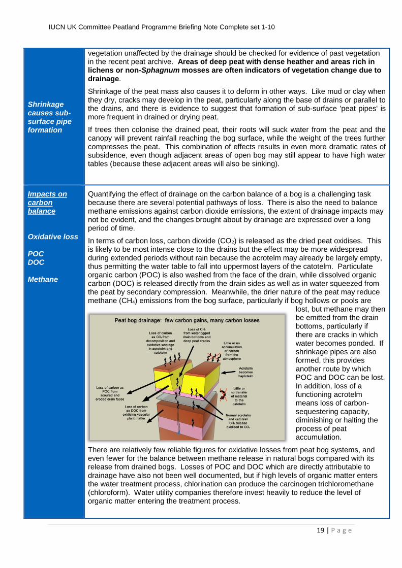
Quantifying the effect of drainage on the carbon balance of a bog is a challenging task because there are several potential pathways of loss. There is also the need to balance methane emissions against carbon dioxide emissions, the extent of drainage impacts may not be evident, and the changes brought about by drainage are expressed over a long period of time.
In terms of carbon loss, carbon dioxide (CO2) is released as the dried peat oxidises. This is likely to be most intense close to the drains but the effect may be more widespread during extended periods without rain because the acrotelm may already be largely empty, thus permitting the water table to fall into uppermost layers of the catotelm. Particulate organic carbon (POC) is also washed from the face of the drain, while dissolved organic carbon (DOC) is released directly from the drain sides as well as in water squeezed from the peat by secondary compression. Meanwhile, the drier nature of the peat may reduce methane (CH4) emissions from the bog surface, particularly if bog hollows or pools are
lost, but methane may then be emitted from the drain bottoms, particularly if there are cracks in which water becomes ponded. If shrinkage pipes are also formed, this provides another route by which POC and DOC can be lost. In addition, loss of a functioning acrotelm means loss of carbon-sequestering capacity, diminishing or halting the process of peat accumulation.
There are relatively few reliable figures for oxidative losses from peat bog systems, and even fewer for the balance between methane release in natural bogs compared with its release from drained bogs. Losses of POC and DOC which are directly attributable to drainage have also not been well documented, but if high levels of organic matter enters the water treatment process, chlorination can produce the carcinogen trichloromethane (chloroform). Water utility companies therefore invest heavily to reduce the level of organic matter entering the treatment process.
IUCN UK Committee Peatland Programme Briefing Note Complete set 1-10
20 | P a g e
Subsidence of 1-2 cm/yr, with perhaps 0.5 cm being carbon loss
Long-term figures for overall subsidence indicate that, after the initial rapid effects of primary consolidation, long-term subsidence of bog peat is typically around 1-2 cm per year, and measurements of CO2 emissions suggest that up to 0.5 cm per year of this may be due to oxidative loss. POC losses tend to be greatest when the drains are first dug, but also during periods of heavy rain. Meanwhile DOC release appears to be most intense during heavy rain following a dry period.
Impacts on micro-topography and bog vegetation
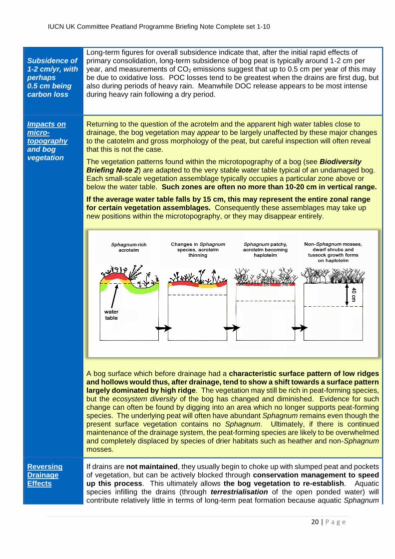
Returning to the question of the acrotelm and the apparent high water tables close to drainage, the bog vegetation may appear to be largely unaffected by these major changes to the catotelm and gross morphology of the peat, but careful inspection will often reveal that this is not the case.
The vegetation patterns found within the microtopography of a bog (see Biodiversity Briefing Note 2) are adapted to the very stable water table typical of an undamaged bog. Each small-scale vegetation assemblage typically occupies a particular zone above or below the water table. Such zones are often no more than 10-20 cm in vertical range.
If the average water table falls by 15 cm, this may represent the entire zonal range for certain vegetation assemblages. Consequently these assemblages may take up new positions within the microtopography, or they may disappear entirely.
A bog surface which before drainage had a characteristic surface pattern of low ridges and hollows would thus, after drainage, tend to show a shift towards a surface pattern largely dominated by high ridge. The vegetation may still be rich in peat-forming species, but the ecosystem diversity of the bog has changed and diminished. Evidence for such change can often be found by digging into an area which no longer supports peat-forming species. The underlying peat will often have abundant Sphagnum remains even though the present surface vegetation contains no Sphagnum. Ultimately, if there is continued maintenance of the drainage system, the peat-forming species are likely to be overwhelmed and completely displaced by species of drier habitats such as heather and non-Sphagnum mosses.
Reversing Drainage Effects
If drains are not maintained, they usually begin to choke up with slumped peat and pockets of vegetation, but can be actively blocked through conservation management to speed up this process. This ultimately allows the bog vegetation to re-establish. Aquatic species infilling the drains (through terrestrialisation of the open ponded water) will contribute relatively little in terms of long-term peat formation because aquatic Sphagnum
IUCN UK Committee Peatland Programme Briefing Note Complete set 1-10
21 | P a g e
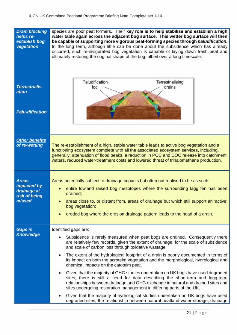
Drain blocking helps re-establish bog vegetation Terrestrialis-ation Palu-dification
species are poor peat formers. Their key role is to help stabilise and establish a high water table again across the adjacent bog surface. This wetter bog surface will then be capable of supporting more vigorous peat-forming species through paludification. In the long term, although little can be done about the subsidence which has already occurred, such re-invigorated bog vegetation is capable of laying down fresh peat and ultimately restoring the original shape of the bog, albeit over a long timescale.
Other benefits of re-wetting
The re-establishment of a high, stable water table leads to active bog vegetation and a functioning ecosystem complete with all the associated ecosystem services, including, generally, attenuation of flood peaks, a reduction in POC and DOC release into catchment waters, reduced water-treatment costs and lowered threat of trihalomethane production.
Areas impacted by drainage at risk of being missed
Areas potentially subject to drainage impacts but often not realised to be as such:
entire lowland raised bog mesotopes where the surrounding lagg fen has been drained;
areas close to, or distant from, areas of drainage but which still support an 'active' bog vegetation;
eroded bog where the erosion drainage pattern leads to the head of a drain.
Gaps in Knowledge
Identified gaps are:
Subsidence is rarely measured when peat bogs are drained. Consequently there are relatively few records, given the extent of drainage, for the scale of subsidence and scale of carbon loss through oxidative wastage.
The extent of the hydrological footprint of a drain is poorly documented in terms of its impact on both the acrotelm vegetation and the morphological, hydrological and chemical impacts on the catotelm peat.
Given that the majority of GHG studies undertaken on UK bogs have used degraded sites, there is still a need for data describing the short-term and long-term relationships between drainage and GHG exchange in natural and drained sites and sites undergoing restoration management in differing parts of the UK.
Given that the majority of hydrological studies undertaken on UK bogs have used degraded sites, the relationship between natural peatland water storage, drainage
IUCN UK Committee Peatland Programme Briefing Note Complete set 1-10
22 | P a g e
and flood-water discharge is not yet well understood. Of particular interest are questions of 'surface roughness' and peat-forming vegetation compared with drainage-induced vegetation which is not peat-forming, and also in terms of the active storage capacity of the natural acrotelm and catotelm.
In blanket mires, loss of particulate matter and dissolved organic carbon from drained areas also remains relatively poorly documented. Consequently the relationship between drainage in the catchment and levels of trihalomethane production within peat-dominated catchments used for public water supplies merits appropriate examination and monitoring.
Practical Actions
Practical actions:
Careful long-term measurement of peat subsidence across relevant microtope and mesotope areas, linked to measurements of water-table behaviour, wherever there is peatland drainage.
Encourage the recovery of peat-forming vegetation, particularly of terrestrial Sphagnum species through paludification, by the blocking of drainage ditches, and, where appropriate, erosion gullies. Such actions can potentially be assisted and encouraged by the reintroduction of Sphagnum.
Establish national catalogue of near-natural peatbog sites which can be used as reference sites in GHG and hydrological studies.
More Information
Underpinning scientific report: http://www.rspb.org.uk/Images/Peatbogs_and_carbon_tcm9-255200.pdf (low resolution) http://www.uel.ac.uk/erg/PeatandCarbonReport.htm (high resolution : downloadable in sections) IUCN UK Peatland Programme: http://www.iucn-uk-peatlandprogramme.org/ Natural England Uplands Evidence Review: http://www.naturalengland.org.uk/ourwork/uplands/uplandsevidencereviewfeature.aspx Scottish Natural Heritage Report on peat definitions: http://www.snh.org.uk/pdfs/publications/commissioned_reports/701.pdf Peatland Action: http://www.snh.gov.uk/climate-change/what-snh-is-doing/peatland-action/
This briefing note is part of a series aimed at policy makers, practitioners and academics to help explain the ecological processes that underpin peatland function. Understanding the ecology of peatlands is essential when investigating the impacts of human activity on peatlands, interpreting research findings and planning the recovery of damaged peatlands.
These briefs have been produced following a major process of review and comment building on an original document: Lindsay, R. 2010 ‘Peatbogs and Carbon: a Critical Synthesis’ University of East London. published by RSPB, Sandy. http://www.rspb.org.uk/Images/Peatbogs_and_carbon_tcm9-
255200.pdf, this report also being available at high resolution and in sections from:
http://www.uel.ac.uk/erg/PeatandCarbonReport.htm
The full set of briefs can be downloaded from:www.iucn-uk-peatlandprogramme.org.uk
The International Union for the Conservation of Nature (IUCN) is a global organisation, providing an influential and authoritative voice for nature conservation. The IUCN UK Peatland Programme promotes peatland restoration in the UK and advocates the multiple benefits of peatlands through partnerships, strong science, sound policy and effective practice.
IUCN UK Committee Peatland Programme Briefing Note Complete set 1-10
23 | P a g e
We are grateful to Scottish Natural Heritage, Natural England, Natural Resources Wales, the Forestry Commission RSPB Scotland and the Peter de Haan Charitable Trust for funding support.
Authors Date
Richard Lindsay, Richard Birnie, Jack Clough Version Date: 5th November 2014
IUCN UK Committee Peatland Programme Briefing Note Complete set 1-10
24 | P a g e
IUCN UK Committee Peatland Programme BriBr Briefing Note No4
Ecological Impacts of Forestry on Peatlands
Do trees occur naturally on UK peat bogs?
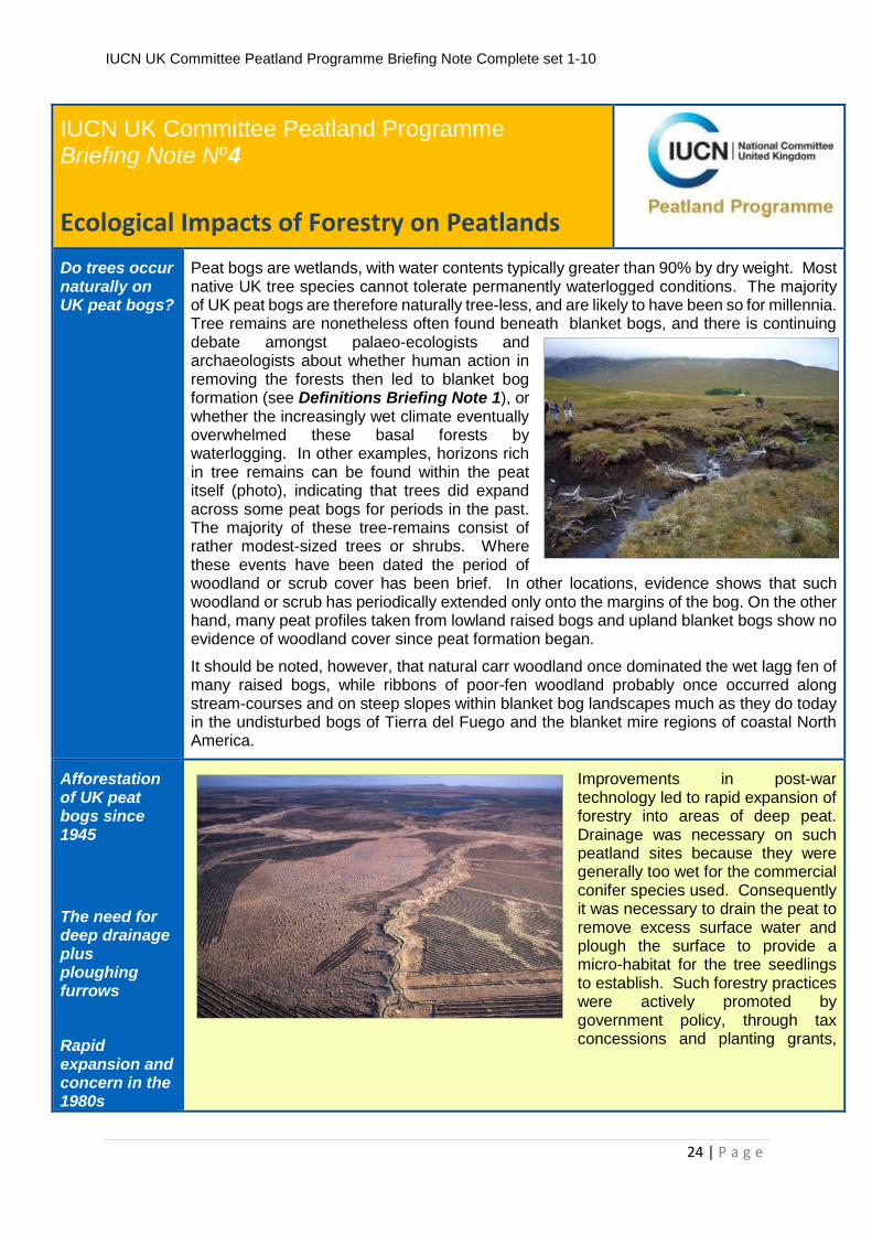
Peat bogs are wetlands, with water contents typically greater than 90% by dry weight. Most native UK tree species cannot tolerate permanently waterlogged conditions. The majority of UK peat bogs are therefore naturally tree-less, and are likely to have been so for millennia. Tree remains are nonetheless often found beneath blanket bogs, and there is continuing debate amongst palaeo-ecologists and archaeologists about whether human action in removing the forests then led to blanket bog formation (see Definitions Briefing Note 1), or whether the increasingly wet climate eventually overwhelmed these basal forests by waterlogging. In other examples, horizons rich in tree remains can be found within the peat itself (photo), indicating that trees did expand across some peat bogs for periods in the past. The majority of these tree-remains consist of rather modest-sized trees or shrubs. Where these events have been dated the period of woodland or scrub cover has been brief. In other locations, evidence shows that such woodland or scrub has periodically extended only onto the margins of the bog. On the other hand, many peat profiles taken from lowland raised bogs and upland blanket bogs show no evidence of woodland cover since peat formation began.
It should be noted, however, that natural carr woodland once dominated the wet lagg fen of many raised bogs, while ribbons of poor-fen woodland probably once occurred along stream-courses and on steep slopes within blanket bog landscapes much as they do today in the undisturbed bogs of Tierra del Fuego and the blanket mire regions of coastal North America.
Afforestation of UK peat bogs since 1945
The need for deep drainage plus ploughing furrows
Rapid expansion and concern in the 1980s
Improvements in post-war technology led to rapid expansion of forestry into areas of deep peat. Drainage was necessary on such peatland sites because they were generally too wet for the commercial conifer species used. Consequently it was necessary to drain the peat to remove excess surface water and plough the surface to provide a micro-habitat for the tree seedlings to establish. Such forestry practices were actively promoted by government policy, through tax concessions and planting grants,
IUCN UK Committee Peatland Programme Briefing Note Complete set 1-10
25 | P a g e
Development of multi-benefit sustainable forestry International commitments to biodiversity and to sustainable forestry objectives No new planting on peat Movement away from re-stocking, but planting targets are still a driver
government research, advice, regulation and activities on state forest land. By the early 1980s, environmental concerns were being expressed about such forest expansion1.
Over the next decade forestry policy in the UK began to respond more sympathetically to biodiversity and environmental issues. Development of policy, grants and regulation for ‘multi-benefit sustainable forestry’ in the UK was facilitated by changes in 1985 to the Forestry Commission’s statutory duties in Great Britain. International concern increasingly focused on the sustainability of forestry practices and biodiversity conservation in relation to both tropical rainforests and temperate plantations, and included discussions at the UN Conference on Environment and Development (Rio ‘Earth Summit’) in 1992. At the same time, the EU Habitats Directive identified raised bog and blanket bogs as habitats of EU 'concern', listing them under Annex 1 of the Directive for special conservation measures. The UK Biodiversity Action Plan (1994) which arose from Earth Summit discussions also included blanket and raised bogs as priority habitats with restoration targets. Subsequent country forestry and biodiversity strategies clearly highlighted the need for forestry practices to be consistent with these goals. Government commitments to adopting a more sustainable approach to forestry were detailed in Sustainable Forestry – the UK Action Programme in 1994. This was followed by the introduction of minimum mandatory sustainability requirements for all forestry planting and woodland management in the UK Forestry Standard (1998, 2004 & 2011). This was supported by peatland planting guidance for GB – Forests & Peatland Habitats2 – and Northern Ireland’s Statement on Afforestation3, as well as the introduction of environmental impact assessment for afforestation.
Extensive areas of peat bog, both lowland raised bog and upland blanket bog (see Definitions Briefing Note 1) have nonetheless been planted during the past 60 years as a result of past polices and incentives. Many such plantations are now approaching the end of the first rotation. They would normally then be felled and re-planted but current practice is changing. The forestry regulators in the UK4 no longer permit new planting on deep peat (over 50cm) and there is now no requirement for restocking of felled plantations on certain deep peat areas. Nonetheless while current policy and regulatory measures have helped to reduce the threat to peatland habitats from new afforestation, the restocking of plantation trees on areas of restorable peatland habitats continues to be actively promoted by certain policy drivers.
Impacts of afforestation
Evapo-transpiration
Interception
Subsidence
The establishment of trees is a significant impact on any bog ecosystem because of the immediate effects of ploughing (see Drainage Briefing Note 3) and then the continued disturbance of the water balance due to the growing trees. Water is lost by evapo-transpiration from the trees and, as the tree canopies develop and close, water is further prevented from reaching the bog surface by interception. This can reduce the amount of water reaching the bog surface by as much as 40%. In addition, the weight of the trees and the loss of water from the peat cause the peat surface to subside (see Drainage Briefing Note 3), with consequent hydrological effects on adjacent areas of peat bog as well as on the properties of the peat beneath the plantation itself. Shading from the trees and needle
1 For example see:
Bainbridge, I.P., Housden, S.D., Minns, D.W. & Lance, A.N. (1987) Forestry in the Flows of Caithness & Sutherland. RSPB Conservation Topic Paper 18, June 1987. RSPB, Edinburgh & Sandy.
Tompkins, S.C. (1986) Theft of the Hills. Rambler's Association, London.
Watkins, C. (1991) Nature Conservation & the New Lowland Forests. Nature Conservancy Council, Peterborough. 2 Patterson, G. & Anderson, R. (2000) Forests & Peatland Habitats. July 2000. Forestry Commission Guideline Note 1, Forestry Commission,
Edinburgh. http://www.forestry.gov.uk/PDF/fcgn1.pdf/$FILE/fcgn1.pdf 3 DANI (1993) Statement on Afforestation. Department of Agriculture Northern Ireland, Belfast. http://www.dardni.gov.uk/afforestation-
IUCN UK Committee Peatland Programme Briefing Note Complete set 1-10
26 | P a g e
Indirect impacts Edge effect Loss of peatland birds Reduction in overall ecosystem services
fall may have a negative impact on the peat-forming Sphagnum mosses, potentially further inhibiting peat formation.
Tree plantations also have impacts on the biodiversity of peatlands not merely through direct habitat loss, but also through modification of adjacent habitat (the edge effect) and through the introduction of alien predators. Recent research has shown these edge effects to be particularly critical to populations of breeding birds that utilise peatlands. In wildlife conservation terms, the loss of specialised peatland ecosystem biodiversity characterised mainly by tundra species including breeding birds of international importance outweighs the gains in additional species from forest planting (e.g. a range of songbirds, and birds of prey which have alternative land-use available, unlike peatland-dependent species). In general, the composite range of services provided by an undisturbed peatland ecosystem will tend to be lost or substantially reduced if the ecosystem is, or remains, wholly or partially planted with conifers. Adjacent unplanted parts may appear superficially to remain unaffected by such actions, but the morphology, hydrology and biodiversity will undergo change over time (see Drainage Briefing Note 3).
Carbon balance of planting on peat
Planting on deep peat increases net GHG emissions
When plantation forestry is established on a living bog surface (see Biodiversity Briefing Note 2) the capacity for active carbon sequestration by the peatland can be greatly reduced or completely lost. Furthermore, the carbon stored over millennia in the catotelm peat will undergo drying and compression beneath the growing trees, and may be released in the form of GHG to the atmosphere or as particulate and dissolved carbon into water courses, then eventually into the atmosphere. By way of a balance, growing trees do sequester carbon from the atmosphere and accumulate carbon stores of their own in the forms of wood products, leaf litter and root tissues.
There is therefore a critical trade-off between the GHG benefits obtained through the sequestration and storage of carbon by trees, and the GHG costs in terms of carbon lost from the peat through oxidative and particulate emissions combined with loss of sequestration capacity of the original bog ecosystem. It is generally recognised that tree plantations on deep peat result in increased net greenhouse gas emissions. Conversely, where plantation forests are removed from peat bogs and the bog ecosystem are restored through hydrological management, evidence suggests a long-term positive benefit with a net reduction in greenhouse gases together with wider ecosystem benefits in terms of water quality and biodiversity.
Restoration after afforestation
Several successful major programmes Policy and regulatory support
Substantial restoration of peatland habitat within formerly-planted areas is now occurring across the UK, with major peat-bog restoration programmes undertaken on both state and private forestry land (e.g. the Border Mires Restoration Project, and the RSPB restoration programme at Forsinard, Sutherland). These various restoration schemes have demonstrated considerable success in restoring active bog habitat from plantations.
Such restoration activities have been assisted by important, if limited, policy and regulatory measures such as restoration grants in Scotland, changes to felling licensing rules or procedures to permit peatland restoration without compulsory replanting, and in some areas not requiring off-site ‘compensatory’ replacement tree planting for peatland restoration sites.
Where peat bog restoration is the alternative to maintaining the forest crop, the carbon bound up in a restored acrotelm (see Biodiversity
IUCN UK Committee Peatland Programme Briefing Note Complete set 1-10
27 | P a g e
Vigorous Sphagnum carpet can hold as much carbon as plantations Improved ecosystem services
Briefing Note 2) can be measured against the carbon store and sequestration-rate of the plantation standing crop. A vigorously-growing carpet of Sphagnum mosses around 20 cm thick contains the same amount of carbon per hectare as a 60-year old plantation of Lodgepole Pine grown on deep peat. A Sphagnum moss layer of around 25 cm provides the equivalent to that found in the more commercially-attractive plantations of Sitka Spruce planted on deep peat. The important difference between forested examples and restored Sphagnum-rich examples is that the former generally diminish the scale and range of other services obtained from the peatland ecosystem while the latter provide an increasingly wide range of peatland ecosystem services as habitat recovery progresses.
Areas of particular concern
Areas of particular concern include:
Any areas of bog with existing plantation forestry and any surrounding hydrologically-connected peatland (i.e. potentially all parts of the “tope” system – see Definitions Briefing Note 1, Biodiversity Briefing Note 2 and Drainage Note 3).
Areas approaching second rotation are also of particular significance.
Gaps in Knowledge
Identified gaps are:
Whole-system values for the relative GHG balance of forestry plantations on peat and the same peat bog undergoing restoration management.
Comparative effects on other peatland ecosystem services in relation to plantations on peat and the same systems undergoing restoration management.
Long term studies into peat bog restoration following felling to determine impacts on GHG, water and biodiversity.
Practical Actions
Practical actions:
The removal of appropriate plantations as set out by current guidance.
Implementation of peatland restoration plans based on current best practice.
Research to establish the ecosystem benefits arising from plantations on peat compared with peat bog ecosystems undergoing restoration management.
More Information
Underpinning scientific report: http://www.rspb.org.uk/Images/Peatbogs_and_carbon_tcm9-255200.pdf (low resolution) http://www.uel.ac.uk/erg/PeatandCarbonReport.htm (high resolution : downloadable in sections) IUCN UK Peatland Programme: http://www.iucn-uk-peatlandprogramme.org/ Forest Research: http://www.forestry.gov.uk/website/forestresearch.nsf/ByUnique/INFD-7J5E7F Natural England Uplands Evidence Review: http://www.naturalengland.org.uk/ourwork/uplands/uplandsevidencereviewfeature.aspx Scottish Natural Heritage Report on peat definitions: http://www.snh.org.uk/pdfs/publications/commissioned_reports/701.pdf Peatland Action: http://www.snh.gov.uk/climate-change/what-snh-is-doing/peatland-action/
IUCN UK Committee Peatland Programme Briefing Note Complete set 1-10
28 | P a g e
This briefing note is part of a series aimed at policy makers, practitioners and academics to help explain the ecological processes that underpin peatland function. Understanding the ecology of peatlands is essential when investigating the impacts of human activity on peatlands, interpreting research findings and planning the recovery of damaged peatlands.
These briefs have been produced following a major process of review and comment building on an original document: Lindsay, R. 2010 ‘Peatbogs and Carbon: a Critical Synthesis’ University of East London. published by RSPB, Sandy. http://www.rspb.org.uk/Images/Peatbogs_and_carbon_tcm9-
255200.pdf, this report also being available at high resolution and in sections from:
http://www.uel.ac.uk/erg/PeatandCarbonReport.htm
The full set of briefs can be downloaded from:www.iucn-uk-peatlandprogramme.org.uk
The International Union for the Conservation of Nature (IUCN) is a global organisation, providing an influential and authoritative voice for nature conservation. The IUCN UK Peatland Programme promotes peatland restoration in the UK and advocates the multiple benefits of peatlands through partnerships, strong science, sound policy and effective practice.
We are grateful to Scottish Natural Heritage, Natural England, Natural Resources Wales, the Forestry Commission RSPB Scotland and the Peter de Haan Charitable Trust for funding support.
Authors Date
Richard Lindsay, Richard Birnie, Jack Clough Version Date: 5th November 2014
IUCN UK Committee Peatland Programme Briefing Note Complete set 1-10
29 | P a g e
IUCN UK Committee Peatland Programme BriBr Briefing Note No5
Domestic peat extraction
History of peat extraction
Main source of fuel
Traditional methods Peat rights Peat banks may be in remote loctions distant from habitation Peat roads
Peat has been used as a fuel and for heating for thousands of years. More than 2,000 years ago the Roman chronicler Pliny described the cutting of 'soil' for fuel by communities who lived on the north-western fringes of the Roman Empire. Islands such as the Shetlands, where there has never been a substantial woodland cover at any time since the last Ice Age, have much archaeological evidence for Neolithic, Bronze Age and Iron Age cultures in the form of chambered cairns, burnt mounds and fortified villages. These apparently thriving societies most probably used peat as their main source of fuel and heating in the absence of any other widespread alternative.
Such domestic cutting of peat is traditionally carried out on individual peat 'banks' which take the form of a cut peat face, often no more than 10 or 20m long, though sometimes extending for as much as 100m. The peat is cut using a special spade which has many different local names and designs, and each face is as tall as either one or two cuts from this spade (left). Each year the face retreats further across the peat bog as a thickness of approximately 10 cm is removed from the peat face in the
form of individual 'turves' or 'peats'. These are allowed to air-dry, heaped up for collection (above), and then gathered to form a peat stack which represents the annual fuel supply. Such stacks are therefore normally located close to the dwelling. There are often rights or social agreements about the location of individual peat banks within a community, and if a particular bank is considered to have been 'worked out' (right) or become unsuitable because of the nature of the peat, arrangements are normally in place to agree or permit the opening of a new bank.
Although for ease of use the peat stack is generally stored close to the dwelling place and the bank from which the turves are obtained may be located nearby, the bank may sometimes lie a very considerable distance from the dwelling. In the case of blanket bog (see Definitions Briefing Note 1) some of the deepest peat deposits develop across broad watershed ridges which may represent the highest landscape features furthest from human habitation. Even within living memory, these distant peat banks were visited using well-established ‘peat roads’ or ‘peat tracks’ and the
IUCN UK Committee Peatland Programme Briefing Note Complete set 1-10
30 | P a g e
turves were transported home using ponies, cattle or simply carried in creels or baskets. It is therefore important to appreciate that domestic peat cutting can be a significant feature even in the remotest parts of a landscape (below).
Source: Google maps, Data provider: Google
The other key feature of domestic peat cutting is that it generally requires a peat face from which to cut the turves. Any attempt to cut a peat face into the flattest, wettest central parts of a typical bog system would face many challenges, particularly as the microtopography of such areas may include wet hollows and pools (see Biodiversity Briefing Note 2). Consequently peat banks have often been positioned on slopes, thus ensuring that the bog surface has a simpler structure and that the ground below the face lies at a lower level than the face itself. Such slopes with simple microtopographic structure tend to occur towards the margins of distinct bog units (mesotopes – see Definitions Briefing Note 1). Thus the areas where evidence for domestic peat cutting can most readily be found tends to be close to habitation on the edges of valleyside mesotopes, or on gently-sloping peat-covered hill-slopes, or on the sloping margins of watershed bog mesotopes. (see Definitions Briefing Note 1).
One rather short-lived technological innovation in the 1980s and 1990s appeared to dispense with this need cutting the peat rapidly and extruding it as ‘peat sausages’ (right) through mechanical means, which allowed peat to be extracted faster and on a greater scale than hand cutting alone. Other mechanical methods employ JCBs or HiMACS.
IUCN UK Committee Peatland Programme Briefing Note Complete set 1-10
31 | P a g e
Impacts of peat extraction Collective impact Loss of marginal lagg fen Small loss but major impact Heather as an indicator Impacts on blanket bogs Initiate erosion
Increased risk of mass movement
The rate of peat extraction outstrips the rate at which peat is deposited. Peat typically accumulates at approximately 0.5 - 1mm per year which means a 1 metre depth of peat can take 1,000 years to form (see Definitions Briefing Note 1). Cutting by hand involves the removal of the acrotelm (see Biodiversity Briefing Note 2) with its actively growing vegetation, but this vegetated layer is often placed down onto the lowered surface of the
bog at the foot of the peat bank. Consequently an individual domestic peat bank may appear to have a relatively low impact on the peatland ecosystem, but while individually this may the case, the collective impacts over an extended period of time (left) can be considerable, even dramatic.
Thus, in the lowlands, not one single raised bog still possesses the wet lagg fen margin that represents the natural transition zone between deep-peat habitat and
mineral ground, and which is fundamental to maintaining the overall water table of a raised bog. In the majority of cases this loss of this natural bog margin has been caused by domestic peat cutting which has nibbled away the fundamentally-important edge of the bog. Even these apparently small losses of peat can have a major impact because the cut peat face acts like a one-sided drain (see Drainage Briefing Note 3).
An increased heather abundance on a bog is sometimes misunderstood as a sign of a healthy bog, while in fact it is the opposite, a sign that the bog is drying out Heather is not generally a significant peat-forming species and its presence in abundance is associated with degradation of the carbon store. Indeed dense stands on deep peat can be used as an indicator of damage, on lowland raised bogs often as a result of drainage caused by marginal domestic peat cutting. In some cases, domestic cutting has been so extensive that almost the entire dome of the raised bog has been cut way to leave just a small upstanding block of increasingly dry raised bog peat dominated by heather and invading birch or pine woodland.
In blanket bog landscapes, extensive areas of peat have been dug for domestic use in the bogland areas around townships, but what is not often recognised is that significant areas have also been cut far away from such townships, up on the margins of deep peat deposits in the uplands. Such areas have supplied fuel and heating to communities for centuries or even millennia, and some of these cuttings may even date back to Neolithic or Bronze Age times. The effect over time may thus have been considerable, particularly where peat cutting was undertaken on the margins of deep peat deposits straddling watersheds or spurs, because the margins of such areas can be as sensitive to drainage as the margins of lowland raised bogs. Peat banks which cut into the edge of deep, wet peat systems can initiate erosion which is then capable of spreading across the whole bog system. Such impacts have until now gone largely un-noticed and un-recorded.
Domestic peat extraction causes carbon losses mainly through bulk removal and oxidative loss, although carbon losses from DOC and POC will also occur to a lesser extent. Extraction may cause localised loss of active bog vegetation which, combined with the physical disruption to the hydrology caused by removal of the peat, can lead to a reduction in bog ecosystem function (see Drainage and Biodiversity Briefing Notes 2 & 3). Peat cutting has also been shown to increase the risk of peat mass movements such as bog slides because the peat bank constitutes a break in the fibrous vegetation mat which binds the bog system securely on a slope. Drainage offers the potential for cracks to develop
IUCN UK Committee Peatland Programme Briefing Note Complete set 1-10
32 | P a g e
Mechanised cutting has not proved successful
in the peat, thus permitting heavy rainfall to reach and lubricate the junction between the peat and the mineral sub-soil. The peat archive is also a substantial and irreplaceable archaeological record. The extracted peat represents an absolute loss of part of this record which cannot be replaced.
Attempts have been made to mechanise domestic peat cutting, most notably using the Difco extrusion system (see Page 2). These have led not only to more dramatic damage to the bog system, but have also proved to have their own set of practical problems. In general, mechanised cutting has more serious impacts on the ecology and functioning of a peat bog than does hand cutting.
Areas at risk All UK raised and blanket bogs, especially areas on which individuals have the right to cut peat and any surrounding hydrologically-connected areas.
Other benefits from addressing this issue
Large carbon losses from domestic peat cutting are inevitable. Sensitive positioning of peat banks and instigation of good restoration techniques can reduce, although not avoid, the impacts described above.
Gaps in Knowledge
Identified gaps:
A clear picture is needed of the extent to which domestic peat cutting has had a significant impact on the UK peat bog resource, addressing in particular the extent of old, even prehistoric, cutting. Amongst other things, this information could be used to identify areas at risk from slope failure and peat slides as a result of cutting.
By addressing the question of extent and age of cutting, it would also be possible to estimate the recovery rate displayed by domestic cuttings both in terms of their vegetation and rate of carbon sequestration.
Research focusing on knowledge gaps such as the level of carbon losses from peat banks and how best to restore a vertical peat bank face will provide better understanding and guide practical actions.
Practical Actions
Practical actions:
Encourage the uptake of best practice for the sensitive positioning of new peat banks, and establish restoration plans for abandoned peat banks.
Encourage appropriate restoration of spent peat banks to prevent long-term negative impacts.
More Information
Underpinning scientific report: http://www.rspb.org.uk/Images/Peatbogs_and_carbon_tcm9-255200.pdf (low resolution) http://www.uel.ac.uk/erg/PeatandCarbonReport.htm (high resolution : downloadable in sections) IUCN UK Peatland Programme: http://www.iucn-uk-peatlandprogramme.org/ Natural England Uplands Evidence Review: http://www.naturalengland.org.uk/ourwork/uplands/uplandsevidencereviewfeature.aspx Scottish Natural Heritage Report on peat definitions: http://www.snh.org.uk/pdfs/publications/commissioned_reports/701.pdf Peatland Action:
This briefing note is part of a series aimed at policy makers, practitioners and academics to help explain the ecological processes that underpin peatland function. Understanding the ecology of peatlands is essential when investigating the impacts of human activity on peatlands, interpreting research findings and planning the recovery of damaged peatlands.
These briefs have been produced following a major process of review and comment building on an original document: Lindsay, R. 2010 ‘Peatbogs and Carbon: a Critical Synthesis’ University of East London. published by RSPB, Sandy. http://www.rspb.org.uk/Images/Peatbogs_and_carbon_tcm9-
255200.pdf, this report also being available at high resolution and in sections from:
http://www.uel.ac.uk/erg/PeatandCarbonReport.htm
The full set of briefs can be downloaded from:www.iucn-uk-peatlandprogramme.org.uk
The International Union for the Conservation of Nature (IUCN) is a global organisation, providing an influential and authoritative voice for nature conservation. The IUCN UK Peatland Programme promotes peatland restoration in the UK and advocates the multiple benefits of peatlands through partnerships, strong science, sound policy and effective practice.
We are grateful to Scottish Natural Heritage, Natural England, Natural Resources Wales, the Forestry Commission RSPB Scotland and the Peter de Haan Charitable Trust for funding support.
Authors Date
Richard Lindsay, Richard Birnie, Jack Clough Version Date: 5th November 2014
IUCN UK Committee Peatland Programme Briefing Note Complete set 1-10
34 | P a g e
IUCN UK Committee Peatland Programme BriBr Briefing Note No6
Commercial peat extraction
Purposes and Impacts peat formation Focus on lowland raised mires Rates of extraction Impacts on blanket bogs Extractive mining or sustainable harvesting?
Commercial peat extraction usually for energy or horticulture, physically removes peat from the ground (see below), along with its stored carbon, at a rate which substantially exceeds the original rate of deposition and accumulation. In the UK, commercial extraction is largely but not exclusively restricted to lowland raised mires (see Definitions Briefing Note 1) which are the least abundant of the UK’s bogs, occupying an area 77% smaller than the area covered by blanket bogs (JNCC 2008).
Natural rates of peat accumulation are less than 2 mm per year, and are outpaced by modern extraction methods that typically remove 100x that depth each year.
Blanket bog (see Definitions Briefing Note 1) is less commonly extracted commercially, but the habitat impact may arguably be even greater where it is extracted because the rate of blanket peat accumulation can be less than half that of raised bogs, while the accumulated peat deposit is invariably much thinner and so the resource may be exhausted much sooner. There may also be consequences for drinking-water supplies (see below).
Despite efforts being made towards sustainable management and post-harvesting restoration, commercial peat extraction in its current guise can only be seen as a type of extractive mining rather than a form of sustainable harvesting. This is because re-growth of peat is too slow to support repeat commercial extraction on any meaningful timescale.
IUCN UK Committee Peatland Programme Briefing Note Complete set 1-10
35 | P a g e
Fuel peat is classed by the EU as a fossil fuel Target to end peat use by 2030
Commercial fuel peat may be obtained using standard peat milling techniques which repeatedly strip off thin layers of loosened peat (see below), or may be extracted using such techniques as 'sod cutting' and 'sausage extraction'. In the UK, fuel peat is almost exclusively extracted commercially from blanket bogs. Although it has been claimed that such fuel peat should be classed as a sustainable biofuel, the EU has officially defined peat as a fossil fuel.
In the UK, peat is in demand largely as a horticultural growing medium and soil conditioner, and its use is increasing despite increasing take-up of alternatives to peat because the whole horticultural and gardening sector continues to expand. The UK Government has meanwhile stated its ambition for the horticultural sector to end peat use by 2030 through the development of alternative, sustainable, growing media. This ambition, combined with the fact that a number of planning consents have already reached the end of their permitted life or will do so in the coming years, means that there is a significant ongoing need for effective restoration management of these former peat workings. To be successful, such management must address the impact of current commercial extraction methods on the peat bog system.
Extraction methods Removal of acrotelm Removal of 200mm per year Permanent loss of peat archive
The current most widespread method of commercial extraction is surface milling for horticultural peat. This entails removal of the acrotelm, with its living vegetation, to expose the mass of the waterlogged catotelm peat deposit (see Biodiversity Briefing Note 2) beneath. An extensive drainage system is then installed across the site (above). Such site preparation means the loss of almost all biodiversity, all surface pattern and loss of active condition with its associated capacity for resilience (See Biodiversity Briefing Note 2 and Climate Change Briefing Note 10). It also results in a radical change in the hydrology of the site. Loss of the acrotelm and installation of drains together result in a number of effects (see Drainage Briefing Note 3) including subsidence of the bog surface and loss of carbon through oxidation, POC and DOC.
The drains separate the peat mass into long 'milling fields', from which several thin layers of peat are then stripped during a year, amounting to around 200 mm per year. This bulk removal of the peat in the form of the industrial crop represents both loss of carbon and loss of the peat archive. The latter is lost forever because it recorded a particular set of moments in time which cannot be repeated. In the case of carbon, the net result of cutting
IUCN UK Committee Peatland Programme Briefing Note Complete set 1-10
36 | P a g e
Extraction may increase water treatment costs
and restoring a bog will be a loss of carbon compared to leaving the bog in its natural uncut state.
Areas of commercial peat extraction (generally for fuel peat) in the upper reaches of peat-dominated catchments used for public drinking-water supplies may result in increased water-treatment costs because of the increased levels of DOC and POC and the need to prevent trihalomethane formation (see Drainage Briefing Note 3).
Restoration Critical importance of different Sphagnum species in rate of restoration Sphagnum species typical of ridges and hummocks are more effective Terrestrial-isation vs Paludification Loss of the peat archive is irrevocable
Importance of starting conditions, especially peat depth
Restoration of a milled bog surface depends primarily upon the re-establishment of peat-forming vegetation, most notably Sphagnum bog moss because this provides much of the essential architecture necessary for a functional acrotelm. Although much restoration of commercial extraction sites in the UK has relied on the re-shaping the milled surface and the encouragement of aquatic Sphagnum species such as S. cuspidatum as primary agents of recovery, it should be recognised that the aquatic species of Sphagnum are also the least effective at generating peat. Such terrestrialisation (infilling of open water - see below) also appears to require many decades before more vigorous peat-forming species of Sphagnum are able to colonise the swards of aquatic bog mosses.
Research on milled peat surfaces in Canada and more recently in Germany has therefore concentrated on re-establishment of Sphagnum species more typical of ridges and hummocks where possible, with minimal re-shaping of the peat surface. The methods involve blocking the milling-field drains to raise the water table beneath the milled surface (paludifying it), creation of low peat bunds only where essential to retain moist surface
conditions, then spreading macerated ridge or hummock Sphagnum species across the bare peat surface, generally with a protective layer of straw. Results have been remarkably rapid and successful in re-establishing a rich sward of peat-forming Sphagnum species, thereby establishing at least the initial characteristics of a functional acrotelm.
It is essential to reiterate, however, that even if the full microtopography and species diversity can in time be restored (and there is no evidence as yet to show that this is possible, particularly for rarer and more vulnerable species), the peat archive which had developed over thousands of years can never be restored. Consequently successful restoration cannot be used to justify new extraction.
The work in Canada, backed up by research in Estonia, has also highlighted
the importance of the starting conditions for restoration, particularly in terms of the depth of peat remaining at the end of commercial extraction. Areas with less than 0.5 m of peat remaining over the mineral sub-soil generally show little or no recovery of peatland vegetation, even after some years, particularly as the lowest layers of a raised bog generally consist of ancient fen peat deposits. In contrast, those areas with at least 1 m of peat remaining, and particularly those with significantly more than 1 m of pure bog peat (ombrotrophic peat - see Definitions Briefing Note 1), appear capable of showing rapid recovery to bog vegetation well within the 30-year timeframe required, for example, by the EU Habitats Directive for 'Degraded raised bogs capable of recovery'.
IUCN UK Committee Peatland Programme Briefing Note Complete set 1-10
37 | P a g e
Areas at risk Any areas that are licensed for peat extraction and any surrounding hydrologically connected areas. These may include raised mires, blanket mires and even fens.
Other benefits from addressing this issue
Restoration of the acrotelm and associated active bog vegetation will preserve the remaining carbon store and encourage the long term carbon sink. Water quality downstream will improve as the DOC levels in bog outflow decrease and a range of bog biodiversity will also be restored.
Gaps in Knowledge
Identified gaps are:
The length of time to full recovery of 'active' bog (likely to be site specific).
Optimal restoration methods, particularly in relation to the interplay between terrestrialisation of water bodies (through creation of shallow lagoons across the restoration site) versus the paludification of the peat body (through the blocking of adjacent drains and seeding of bare peat surfaces).
Potential for Sphagnum farming on agriculturalised peat soils.
Practical Actions
Practical actions:
Encouragement towards the use of alternative sustainable growing media.
Further development of restoration techniques for milled peat sites, particularly building on research in the UK, Canada and Germany, in partnership with industry.
Research into the commercial potential for Sphagnum farming on agriculturalised peat soils.
More Information
Underpinning scientific report: http://www.rspb.org.uk/Images/Peatbogs_and_carbon_tcm9-255200.pdf (low resolution) http://www.uel.ac.uk/erg/PeatandCarbonReport.htm (high resolution : downloadable in sections) IUCN UK Peatland Programme: http://www.iucn-uk-peatlandprogramme.org/ Natural England Uplands Evidence Review: http://www.naturalengland.org.uk/ourwork/uplands/uplandsevidencereviewfeature.aspx Scottish Natural Heritage Report on peat definitions: http://www.snh.org.uk/pdfs/publications/commissioned_reports/701.pdf Peatland Action: http://www.snh.gov.uk/climate-change/what-snh-is-doing/peatland-action/
This briefing note is part of a series aimed at policy makers, practitioners and academics to help explain the ecological processes that underpin peatland function. Understanding the ecology of peatlands is essential when investigating the impacts of human activity on peatlands, interpreting research findings and planning the recovery of damaged peatlands.
These briefs have been produced following a major process of review and comment building on an original document: Lindsay, R. 2010 ‘Peatbogs and Carbon: a Critical Synthesis’ University of East London. published by RSPB, Sandy. http://www.rspb.org.uk/Images/Peatbogs_and_carbon_tcm9-
255200.pdf, this report also being available at high resolution and in sections from:
IUCN UK Committee Peatland Programme Briefing Note Complete set 1-10
38 | P a g e
The full set of briefs can be downloaded from:www.iucn-uk-peatlandprogramme.org.uk
The International Union for the Conservation of Nature (IUCN) is a global organisation, providing an influential and authoritative voice for nature conservation. The IUCN UK Peatland Programme promotes peatland restoration in the UK and advocates the multiple benefits of peatlands through partnerships, strong science, sound policy and effective practice.
We are grateful to Scottish Natural Heritage, Natural England, Natural Resources Wales, the Forestry Commission RSPB Scotland and the Peter de Haan Charitable Trust for funding support.
Authors Date
Richard Lindsay, Richard Birnie, Jack Clough Version Date: 5th November 2014
IUCN UK Committee Peatland Programme Briefing Note Complete set 1-10
39 | P a g e
IUCN UK Committee Peatland Programme BriBr Briefing Note No7
Grazing and Trampling
Grazing as part of the bog ecosystem Defining sustainable levels of grazing 0.4 sheep per hectare
Grazing, browsing and trampling by native wild animals are components of natural bog ecosystems in the UK but unsustainable levels of grazing and trampling from grazing livestock (sheep, cattle and deer) can have adverse effects on the peatland ecosystem.
Research evidence suggests that blanket bog vegetation can sustain wild and/or domestic herbivore at relatively low stocking rates (equivalent to around 0.4 sheep per ha or 1 sheep to the acre). Higher densities are not biological sustainable because the total available dry matter production from a blanket bog ecosystem is low relative to the food requirements of large herbivores. Trampling pressure also becomes significant. Consequently there is a risk of vegetation damage even at very low stocking rates, particularly with larger animals, even before taking wild herbivore numbers into account. The graph (right) shows the relationship between sheep stocking rate and annual animal off-take or dietary requirements.
Impacts of grazing animals Sensitivity to trampling
Immediate ecosystem impacts are associated with physical damage to the vegetation and bog surface through trampling, grazing and urine/faecal returns. These include the creation of tracks and small areas of bare peat surface that can act as the focal points for erosion. Indirectly over the long term, there may be a reduction in the annual biomass that is retained in the living surface layer (both above and below ground). This may ultimately lead to a decline in the thickness of the acrotelm, which would result in a lowering of
peatland resilience to change, making sites more susceptible to other damaging events (see Biodiversity Briefing Note 2).
Even native Shetland sheep (above) – a typical small sheep breed – can result in such damage. This is because the keystone Sphagnum species are particularly sensitive to trampling with evidence suggesting that they cannot withstand more than 1 or 2 trampling events in a year, and the trampling damage may persist for several years.
IUCN UK Committee Peatland Programme Briefing Note Complete set 1-10
40 | P a g e
Loss of peat-forming species Increase in bare peat Burning and drainage often accompany stock grazing
The damage caused by grazing is nearly always a long-term (decades) process. Ultimately it results in loss of peat forming vegetation and consequent drying out of the bog surface. In sensitive locations the end-result of persistent high stocking levels is that the acrotelm is lost completely, the drier surface is colonised by non peat-forming species, patches of bare peat appear and erosion-risk increases as a consequence.
In the past, livestock grazing (including deer) has also been intimately associated with burning and drainage of peat bog systems, the former to encourage fresh growth and an 'early bite', the latter to encourage heather or grass growth at the expense of peat-forming vegetation and to minimise the hazard to stock (sheep in particular) posed by very wet ground. Burning and drainage have their own impacts (see Drainage Briefing Note 3 and Burning Briefing Note 8).
Trampling is also a major factor to consider when using fixed-point monitoring Raised platforms and snowshoes while monitoring
Repeated visits kill Sphagnum or prevent recovery
One specialised but important aspect of trampling concerns the effects resulting from scientific or conservation monitoring at fixed locations. Bog vegetation is sensitive to trampling but Sphagnum species are especially sensitive. Repeated visits to monitoring points, even if only once a year, can kill the Sphagnum sward in the space of two or three visits, or prevent Sphagnum recovery at such locations on restoration sites. Raised platforms should be provided for such monitoring points, and snowshoes should be worn while in the vicinity of the monitoring point.
Restoration following overgrazing
As grazing, with its associated trampling, is rarely the only factor involved in the degradation of a site, it is important to address issues such as burning and the presence of drains, but it would seem that a reduction in stocking rates to below 0.4 sheep per hectare or removal of grazing altogether will allow recovery of the vegetation to begin. Heavily-grazed areas which have been largely free from grazing for 10-20 years have been found to show clear signs of recovery in the absence of other pressures.
Sites with a harsher climate, extensive bare peat and high levels of erosion will take longest to recover and may require greater levels of stock reduction and/or wild herbivore control. In all cases, grazing measures should be carried out in concert with other land management measures such as reduced burning and drain blocking.
IUCN UK Committee Peatland Programme Briefing Note Complete set 1-10
41 | P a g e
Areas at risk High stocking rates Burning Pollution Wild herbivores Low levels of stock management
Importance of management history
Bogs which have a long history of high stocking densities of domestic herbivores combined with other uses such as drainage (see Drainage Briefing Note 3), domestic peat extraction (see Domestic Peat Cutting Briefing Note 5) or exposure to frequent burning (see Burning Briefing Note 8) and/or pollution (see Erosion Briefing Note 9) are particularly at risk of damage to the protective cover of peat-forming vegetation. High levels of stocking pressure date back to the early/mid 19th century or even earlier in some places. Furthermore during the 20th century in most places there has been a progressive move away from a seasonal mixed grazing system of sheep and cattle to a year-round system of sheep only, and a progressive increase in stock numbers during the latter part of the 20th century associated with headage payments.
The risks increase if the bog also has historically high densities of wild herbivores, particularly red deer. Areas where the level and quality of stock management is low are also more at risk. For example, much of the blanket bog in the north and west of Scotland is managed under common grazing regulations and management inputs are generally low. It is important to note that management history is often more important than the present management in terms of grazing and trampling impacts.
Where damage of various kinds mean that sites have lost a degree of their natural resilience, the additional factor of grazing, even at low intensities, can both stretch this resilience, sometimes to breaking point, and actively hamper any restoration efforts (e.g. continued trampling and grazing on an area of formerly burnt but regenerating peat surface can prevent re-establishment of fragile Sphagnum propagules).
Restored areas on former bare peat surfaces can give rise to their own challenges. In some cases these areas are restored to grassland to prevent erosion of the exposed peat. This has sometimes prompted calls for grazing on the new grassland. The grassland phase is, however, but one step in the restoration process and careful management of grazing levels is needed to aid the transition from grassland to active bog.
Other benefits from addressing the issue
Reduced levels of grazing lead in turn to recovery of bog ecosystem functions, including bog species associations (biodiversity effects), increased carbon uptake and carbon storage, and improvements in water quality. There may also, depending on catchment context, be possible benefits in terms of flood mitigation.
However, reducing grazing alone may not result in full recovery if other damaging activities are taking place and are not resolved.
Gaps in Knowledge
Identified gaps are:
Improved understanding of the precise mechanisms of grazing impacts on natural and damaged bog vegetation and microtopography for a range of domestic and wild species.
Further research into how successful restoration efforts through grazing reductions alone could shed light on appropriate methods of restoration management.
A comprehensive review of the evidence of impacts of grazing and stocking rates in the uplands has been published recently by Natural England (see: http://publications.naturalengland.org.uk/publication/5976513). This provides a summary of published evidence and identifies a range of gaps in current knowledge.
Practical Actions
Practical actions:
Reduction in overall stocking rates, both domestic and wild herbivores (if present).
Adoption of a seasonal grazing regime with all domestic stock removed in winter.
IUCN UK Committee Peatland Programme Briefing Note Complete set 1-10
42 | P a g e
If reduction in stock numbers is not feasible then reduction in effective stocking rates may be achieved by changing to a smaller breed of sheep (Graph above).
More Information
Underpinning scientific report: http://www.rspb.org.uk/Images/Peatbogs_and_carbon_tcm9-255200.pdf (low resolution) http://www.uel.ac.uk/erg/PeatandCarbonReport.htm (high resolution : downloadable in sections) IUCN UK Peatland Programme: http://www.iucn-uk-peatlandprogramme.org/ Natural England Uplands Evidence Review: http://www.naturalengland.org.uk/ourwork/uplands/uplandsevidencereviewfeature.aspx Scottish Natural Heritage Report on peat definitions: http://www.snh.org.uk/pdfs/publications/commissioned_reports/701.pdf Peatland Action: http://www.snh.gov.uk/climate-change/what-snh-is-doing/peatland-action/
This briefing note is part of a series aimed at policy makers, practitioners and academics to help explain the ecological processes that underpin peatland function. Understanding the ecology of peatlands is essential when investigating the impacts of human activity on peatlands, interpreting research findings and planning the recovery of damaged peatlands.
These briefs have been produced following a major process of review and comment building on an original document: Lindsay, R. 2010 ‘Peatbogs and Carbon: a Critical Synthesis’ University of East London. published by RSPB, Sandy. http://www.rspb.org.uk/Images/Peatbogs_and_carbon_tcm9-
255200.pdf, this report also being available at high resolution and in sections from:
http://www.uel.ac.uk/erg/PeatandCarbonReport.htm
The full set of briefs can be downloaded from:www.iucn-uk-peatlandprogramme.org.uk
The International Union for the Conservation of Nature (IUCN) is a global organisation, providing an influential and authoritative voice for nature conservation. The IUCN UK Peatland Programme promotes peatland restoration in the UK and advocates the multiple benefits of peatlands through partnerships, strong science, sound policy and effective practice.
We are grateful to Scottish Natural Heritage, Natural England, Natural Resources Wales, the Forestry Commission RSPB Scotland and the Peter de Haan Charitable Trust for funding support.
Authors Date
Richard Lindsay, Richard Birnie, Jack Clough Version Date: 5th November 2014
IUCN UK Committee Peatland Programme Briefing Note Complete set 1-10
43 | P a g e
IUCN UK Committee Peatland Programme BriBr Briefing Note No8
Burning
Role of fire in bog ecosystems Natural fires Natural time interval of 200 - 300 years Loss of Sphagnum increases recovery time Fire return times from British blanket bogs Most below threshold for a zero carbon balance Controlled burning typically every 15-30 years
Fires occur naturally on bogs, just not very often. They are started by lightning strikes after hot weather when the vegetation is dry. Peat accumulates because it is waterlogged, but peat will burn when dry because it consists almost solely of dead plant material (see Definitions Briefing Note 1). Natural fires on wet peat bog therefore tend to burn only the surface vegetation and drier features such as hummocks but leave much of the wet surface relatively intact. The burning vegetation may, however, cause the peat beneath to catch fire if the peat is unusually dry as a result of previous disturbance.
The peat archive shows that the time interval between lightning-induced natural fires on any specific area of peat bog is in the order of two to three centuries (diagram below). This generally provides sufficient time for the bog surface and vegetation to recover. If the surface has been burnt to the point where all living Sphagnum has been lost, for example, it may take more than 50 years for Sphagnum plants to return when burning has produced a bare peat surface. Full recovery of the ecosystem and its characteristic features is thus a slow process, perhaps somewhat longer than a single human lifetime. Human-induced fires on peat bogs, whether as wildfires or as part of a managed burning regime, generally occur 10x more frequently than natural fire events, with intervals between fires more typically 15-30 years. These high frequencies can lead over time to a reduction in the Sphagnum cover through damage and through increased competition from other species.
IUCN UK Committee Peatland Programme Briefing Note Complete set 1-10
44 | P a g e
Short term carbon gains
Failure to take account of long term carbon trends
Bogs can be shown to exhibit an altered vegetation composition, structure and growth-form due to fire 80 years or more after a fire event. While short term studies that focus on the immediate recovery of the vegetation often see a short term carbon gain due to rapid heather/ graminoid growth, such studies fail to account for the negative long-term carbon trends associated with a damaged acrotelm, consequent impacts on the catotelm, loss of microtopography and overall reduction in environmental resilience. This can lead to the mistaken view that burning is beneficial for both the ecology and the carbon store of a bog.
Impacts of management burning 25-30 years Heather 10-15 years Hare’s –tail cotton grass Impacts of other vegetation types on peat formation Loss of carbon
In terms of impacts, the short 'return times' associated with human-induced fires offer little prospect of full ecosystem recovery and tend to encourage 'fire-tolerant' species at the expense of other peatland species. A fire interval of around 25-30 years will tend to encourage dominance of heather (Calluna vulgaris) with a moss carpet of species which are poor formers of peat. A shorter rotation of 10-15 years will tend to encourage dominance of the highly fire-resistant tussock growth forms of species such as hare's-tail cotton grass (Eriophorum vaginatum), or, in the west of Britain, purple moor grass (Molinia caerulea) and, in the far north of Britain, tussocks of deer grass (Trichophorum cespitosum) with a largely bare peat surface beneath. Although hare's-tail cotton grass is an important peat-forming species, the tussock growth form appears to be particularly associated with initial stages of peat formation and thus often becomes dominant after a peat bog has suffered a set-back (such as a fire) and is in the early stages of re-establishing peat formation. Tussocks of purple moor grass tend to form where the peat surface has lost its moss-rich carpet and water can thus flow readily over and through the damaged peat surface. Deer grass appears to take the place of hare's-tail cotton grass in the far north and west of the UK. Where there is only bare peat or a vegetation cover dominated by species which are not normally peat-forming (including heather), peat formation is not possible and the bog becomes 'non active'. In practice this means that, through drying out and surface erosion, the bog is almost certainly now losing carbon from the long-term carbon store (see Drainage Briefing Note 3 & Erosion Briefing Note 9). Loss of 'active' condition also means that the bog has lost much of its capacity to respond to external pressures such as climate change (see Climate Change Briefing Note 10).
Burning as a restoration method carries a high intrinsic risk Time and water-level management offer a more effective,
Evidence has shown that burning to remove dominance of vascular plants on degraded peat bogs as part of a restoration programme poses serious risk of damage to species associated with re-establishment of a functioning acrotelm. Even with a ‘one-off’ attempt at a cool burn, there are difficulties in controlling the fire to avoid burning the sensitive moss species. Ultimately, in areas of damaged peat currently dominated by vascular plants such as heather (Calluna vulgaris), a functioning acrotelm should re-develop naturally over time without direct intervention provided other negative influences are minimised or removed. On current evidence it may take 80-100 years for a fully-functioning and biodiverse acrotelm to re-establish if left entirely to such natural processes, although key elements and pre-cursors of a functioning acrotelm will generally become established within much shorter timescales in the absence of burning and provided other evident forms of damage can be addressed. In order to increase the speed of acrotelm development, re-wetting is generally the most effective means of hastening
IUCN UK Committee Peatland Programme Briefing Note Complete set 1-10
45 | P a g e
low-risk approach
the process, but may on occasion be further assisted by cutting or mowing of the vascular-plant layer.
Areas at risk All areas of bog peat are vulnerable to the impacts of fire. Shetland is unusual in the UK because evidence for burning in the peat record is comparatively rare, apart from certain areas of central Mainland which, in recent centuries, are known to have been subject to burning management for grazing. Across the remainder of the UK, the evidence stored in the peat archive reveals that during the last few centuries burning has been ubiquitous, and often frequent, even in the remotest parts of the UK. This burning has been generally associated with grazing management for sheep or sporting management for grouse.
Other benefits from addressing the issue
Preventing fire damage will assist in the re-establishment and maintenance of active bog habitat, with resulting ecosystem resilience, maintenance of carbon stores, and other ecosystem-service benefits.
Gaps in Knowledge
Identified gaps are:
The effect of different fire behaviours, fire intervals, and fire intensity, on the full range of ecosystem characteristics, including particularly active bog condition.
Recovery times for full ecosystem recovery in differing parts of the UK.
The long-term carbon balance of burning and recovery.
Comprehensive reviews of the evidence for impacts resulting from managed burning of upland peatland on biodiversity, carbon and water have been published recently by Natural England and University of Leeds. See: http://publications.naturalengland.org.uk/publication/5978072 and http://www.wateratleeds.org/fileadmin/documents/water_at_leeds/EMBER_full_report.pdf)
The NE report provides a systematic review of published evidence, while the University of Leeds report provides recent research evidence. Both reports identify gaps in existing knowledge.
Practical Actions
Practical actions:
The cessation of managed burning on peat bog systems.
Establishment of wildfire-control systems.
Restoration, through re-wetting and re-vegetation, of 'non-active' areas, particularly those most at risk from fire.
More Information
Underpinning scientific report: http://www.rspb.org.uk/Images/Peatbogs_and_carbon_tcm9-255200.pdf (low resolution) http://www.uel.ac.uk/erg/PeatandCarbonReport.htm (high resolution : downloadable in sections) IUCN UK Peatland Programme: http://www.iucn-uk-peatlandprogramme.org/ Natural England Uplands Evidence Review: http://www.naturalengland.org.uk/ourwork/uplands/uplandsevidencereviewfeature.aspx Scottish Natural Heritage Report on peat definitions: http://www.snh.org.uk/pdfs/publications/commissioned_reports/701.pdf
This briefing note is part of a series aimed at policy makers, practitioners and academics to help explain the ecological processes that underpin peatland function. Understanding the ecology of peatlands is essential when investigating the impacts of human activity on peatlands, interpreting research findings and planning the recovery of damaged peatlands.
These briefs have been produced following a major process of review and comment building on an original document: Lindsay, R. 2010 ‘Peatbogs and Carbon: a Critical Synthesis’ University of East London. published by RSPB, Sandy. http://www.rspb.org.uk/Images/Peatbogs_and_carbon_tcm9-
255200.pdf, this report also being available at high resolution and in sections from:
http://www.uel.ac.uk/erg/PeatandCarbonReport.htm
The full set of briefs can be downloaded from:www.iucn-uk-peatlandprogramme.org.uk
The International Union for the Conservation of Nature (IUCN) is a global organisation, providing an influential and authoritative voice for nature conservation. The IUCN UK Peatland Programme promotes peatland restoration in the UK and advocates the multiple benefits of peatlands through partnerships, strong science, sound policy and effective practice.
We are grateful to Scottish Natural Heritage, Natural England, Natural Resources Wales, the Forestry Commission RSPB Scotland and the Peter de Haan Charitable Trust for funding support.
Authors Date
Richard Lindsay, Richard Birnie, Jack Clough Version Date: 5th November 2014
IUCN UK Committee Peatland Programme Briefing Note Complete set 1-10
47 | P a g e
IUCN UK Committee Peatland Programme BriBr Briefing Note No9
Weathering, Erosion and
Mass Movement of Blanket Bog
The erosion problem
Weathering Erosion Vegetation can increase weathering but decrease erosion Peatlands reduce erosion of the underlying sub-soil Water-filled peat accumulates on summits and slopes Little or no evidence of
Weathering is the process of breaking down solid material such as rock into smaller particles, through agents such as heating, freezing and chemical attack. These particles can then be transported away through the process of erosion by agents such as water and wind. Vegetation to some extent insulates bare rock and skeletal soils from these processes by providing a protective layer. The action of plant roots can, however, result in biologically-driven weathering when roots invade cracks and split rock, or release chemicals which transform and break down the parent rock or soil. At the same time, the root systems and fallen leaf litter add organic matter to the soil, increasing its complexity and bulk volume.
Consequently while weathering may continue beneath a vegetation cover, soils tend to become stabilised and thus erosion tends to diminish where there is a blanketing layer of vegetation. Nowhere is this more so than in peatlands, particularly blanket mire landscapes which in the UK tend to occur in upland regions where the agents of weathering and erosion such as rain, frost, wind and slope are particularly marked, and where mineral soils often consist of unconsolidated glacial till ('boulder clay'). Across this unpromising landscape the formation and growth of peat results not merely in stabilisation of the mineral ground surface, but results in soil (peat) accumulation to the extent that many, if not most, of the factors associated with weathering and erosion become dissipated or smothered by the accumulating mass of peat and its living, peat-forming surface vegetation.
Blanket peat development is all the more remarkable, therefore, given that undisturbed peat generally has a water content by weight of between 90% to 98% - in other words, far less solids than milk - yet it is draped across slopes of 35˚ or more and some of the deepest, wettest peats, sometimes displaying extensive mazes of large bog pools, dominate broad watershed hill summits (see Definitions Briefing Note 1). In the Falklands, which are another location of extensive blanket mire, it is said: "The water all sits at the top of the hills."
Such an unlikely set of conditions would appear to be a recipe for long-term disaster. Indeed the fact that blanket mire erosion is so widespread in the UK originally led to the idea that collapse and erosion of these systems was a natural process and therefore unavoidable. However, little or no convincing evidence has been advanced to
IUCN UK Committee Peatland Programme Briefing Note Complete set 1-10
48 | P a g e
natural instability; strong link to human impacts
underpin this belief. In contrast, a body of evidence has since accumulated which links blanket bog weathering, erosion and instability to a variety of human-induced impacts including fire damage, atmospheric pollution, drainage, track construction, trampling and overgrazing, and even to Neolithic tree-removal from hill slopes on the margins of blanket bog systems.
Erosion starts with loss of peat-forming vegetation Erosion is associated with many effects of drainage because gullies resemble drains Some erosion may be caused by Neolithic tree removal
The development of erosional features begins with loss of the living, peat-forming vegetation and thus loss of a functioning acrotelm (see Biodiversity Briefing Note 2), thereby exposing the unprotected catotelm peat to the agents of weathering. Drainage, burning, atmospheric pollution, peat cutting, or trampling and 'rubbing' (caused by sheep or deer sheltering against a weathered peat face) have generally been the primary causes of such acrotelm loss and loosening of the exposed peat surface.
Agents of erosion then remove this loosened peat, leading to formation of large-scale erosion complexes. This may occur through breakdown of an established natural surface pattern with emptying and inter-connection of pools and hollows into a drainage network, which then leads to drying, subsidence and formation of major drainage channels which have much the same impact as artificial drains do on a peat bog (see Drainage Briefing Note 3). Alternatively, breakdown may result from upstream progression of an artificially rejuvenated stream gully (typically straightened and deepened into a drain) which cuts into the peat body from the margins, again ultimately leading to breakdown of the main bog surface and the drainage effects referred to above. It has been suggested that such headward stream erosion may have occurred when scattered tree cover on peat-covered slopes of the Pennines was removed in Neolithic times, this loss of tree cover causing a substantial increase in stream erosion
It must be stressed that erosion is also driven by drying processes which occur at the micro-scale around the margins of bare peat. This leads to extension and expansion of exposed areas of peat and ultimately gives rise to development of erosion gully systems.
Natural bog pattern lies across line of water seepage; erosion is aligned with direction of water flow 'Jigsaw' erosion pattern where slope is low Linear gully erosion on steeper slopes
While the characteristic feature of natural peatland patterns is that the pattern of ridges, hollows and pools lies across the direction of water seepage, the distinctive feature of eroding systems is that the
gullies and haggs are oriented in the same direction as the general pattern of water flow. This is most readily observed from an aerial image using, for example, Google Earth or 'Satellite' view in Google Maps. Summit erosion formed across broad watershed plateaux or on the gentle slopes of valleyside mires (see Definitions Briefing Note 1) tends to result in an interconnected 'jigsaw-like' patterns of gullies and haggs (Type 1 erosion). As slopes become steeper, the typical pattern becomes that of parallel gullies running straight downslope (Type 2 erosion).
Lowland bogs have no gully erosion
It is interesting to note that, despite extensive human impact, lowland raised bogs in the UK show no signs of the severe gully erosion found in blanket mire landscapes. At most, they
IUCN UK Committee Peatland Programme Briefing Note Complete set 1-10
49 | P a g e
Annual loss of carbon from blanket bog erosion equivalent to annual emissions from 700,000 households
Catotelm losses of 3 cm/yr Single storm events important Remarkably little sub-soil exposed
display a degree of micro-erosion in which the surface forms a shallow drainage network between small tussocks.
Blanket bog, on the other hand, represents the largest accumulated terrestrial carbon store in the UK, but, instead of capturing more carbon, it is now actively losing carbon at the rate of around 3.7 million tonnes of CO2e each year, which is roughly equivalent to the annual emissions from 700,000 households.
The main reason for this is that the majority of UK blanket bogs are degraded and many have suffered severe erosion. Only about 18% can be described as being in “near-natural” condition. Over 50% do not have peat forming vegetation and the remainder are so damaged that they are actively weathering, eroding, and in some cases have even suffered catastrophic collapse.
Weathering and erosion together can remove peat from the catotelm at rates of more than 3 cm per year, so a peat depth of 3 m can be lost in just 100 years if such rates are maintained. In fact losses are more closely linked to individual weather events. A single heavy storm after a long dry spell can remove more material in a few hours than had been lost over the whole course of a year.
Severely eroding blanket bog can produce over 30 tonnes of CO2-equivalents per hectare per year. This finds its way off-site both via direct loss to
the atmosphere through oxidation of the peat and as a result of erosion by wind and water. Eroding blanket bog systems are associated with high levels of particulate (POC) and dissolved organic carbon (DOC) which can significantly reduce water quality and substantially increase water-treatment costs, particularly in reducing levels of organic matter in order to prevent production of trihalomethanes (see Drainage Briefing Note 3). Downstream fishery interests may also be affected by increased peat sediment, as may the pattern of downstream flooding.
Regeneration and restoration
Natural regeneration of erosion systems
Complete loss of the peat mass is the last stage in the general degradation of a blanket bog ecosystem. However, given the widespread nature of blanket mire erosion and in some cases its apparent ancient origins, it is surprising how little ground of the uplands has been so completely denuded in this way. Individual gullies may reveal exposed glacial till or bare rock, but wholesale exposure of the underlying mineral soil is extremely rare.
Indeed across extensive areas of eroded blanket bog in the UK there is clear evidence of erosion gullies blocking up and re-wetting naturally, with Sphagnum bog moss choking and ponding the gullies while the characteristic vegetation of erosion haggs - namely heather and/or Racomitrium moss hummocks - is gradually being overwhelmed by a Sphagnum-rich bog
IUCN UK Committee Peatland Programme Briefing Note Complete set 1-10
50 | P a g e
Active systems can be restored within 20-30 years
vegetation. Indeed, even the most severely eroded areas have demonstrated the capacity for such systems to re-establish and become vigorously peat forming within 20-30 years, particularly if natural recovery is assisted by restoration management designed to reduce exposure of bare peat surfaces and slow water movement through the erosion system.
Areas at risk Major stressors Pollution Shedding Vs Receiving sites Drying and cracking of catotelm directs storm water to peat-mineral interface Several major peatslides in recent years Track construction
Blanket bog erosion is a consequence of stressors on blanket bog condition that work in concert to bring about a physical change in the bog ecosystem. Consequently areas most at risk are those which are most subject to such stresses. The principal changes caused by these various forms of stress is disruption of the fibrous living acrotelm layer and exposure of bare peat surfaces.
The major forms of stress are burning, trampling and grazing, artificial drainage and, in the past, atmospheric pollution. These generally act in the short-term by directly creating bare peat surfaces and indirectly through longer-term changes in the hydrology of the system (see Drainage Briefing Note 3) and/or changes in bog vegetation (e.g. loss of keystone peat-forming Sphagnum spp). Specific stressors may be high-intensity fire events, artificial drainage, or heavy trampling/poaching of surfaces by domestic and/or wild herbivores or ATVs.
Historically some areas such as the Pennines have experienced high levels of atmospheric pollution which directly killed the keystone moss species. This is no longer considered to be a major cause of stress because atmospheric pollution levels have diminished substantially in recent years. Aerial pollution may nevertheless continue to result in low-level chronic stress, particularly in terms of ongoing nitrogen inputs which favour vascular plant species that are stronger competitors than the keystone Sphagnum bog moss. In sub-optimal conditions (such as where there is ongoing drainage, or burning, for example) this may constrain somewhat the re-establishment of Sphagnum cover.
Erosion risk may also be determined by the topographic and hydrological context of the bog. Blanket bog systems typically lie on ridge crests or on significant hill slopes. They are therefore intrinsically more susceptible to the forces of water, wind and ice when the protective acrotelm layer is lost. Thus blanket bogs which have been frequently burned, have been drained, and which have a high grazing and trampling pressure, tend to experience the most severe erosion because they have lost the protective peat-forming acrotelm layer. Perhaps more significantly given recent developments, unprotected catotelm peat tends to dry and crack during dry weather, providing routes for subsequent rainstorms to feed storm-water down to the interface between the overlying mass of peat and the underlying glacial till.
This is likely to have been the cause of several major recent peatslides (technically, 'mass movement following slope failure'), particularly where the surface mat of fibrous Sphagnum and cotton-grass roots has additionally been severed by the digging of a drain or the cutting of a peat- bank - sometimes many decades earlier.
Track construction across blanket peat, especially if side-drains are dug severing the fibrous surface mat, provides yet further potential for instability and mass movement resulting from the extra loading on this essentially liquid soil, but may also trigger or exacerbate more typical peatland erosion in the long term (see Tracks Briefing Note 11).
IUCN UK Committee Peatland Programme Briefing Note Complete set 1-10
51 | P a g e
may cause instability
Other benefits from addressing the issue
Reduced levels of burning and grazing, and blocking of artificial drainage systems and erosion gullies, lead to recovery of bog ecosystem functions including:
re-development of bog-species associations;
major reductions in GHG emissions and increased carbon capture and storage;
improvements in water quality (particularly reduction of organic-matter content and reduced likelihood of trihalomethane production;
depending on catchment context, possible flood mitigation;
reduced danger of mass movement/peatslides.
Gaps in Knowledge
Blanket bog erosion has been something of an enigma for many years because it is so widespread and because it has so often in the past been described as a natural end-point of blanket bog development. Establishing clear and definitive links between various forms of human impact and the pattern of blanket bog erosion in the UK is likely to shed light on the way in which such systems should be managed in the future.
The Peatland Compendium provides an extensive information resource about the restoration of eroded blanket bog, based on a large number of restoration projects undertaken across the UK. See: http://www.peatlands.org.uk/
A review of published scientific evidence concerning the restoration of degraded blanket bog has also been undertaken recently by Natural England.
This provides a summary of published evidence and identifies certain key gaps in knowledge concerning restoration of eroded bog, the most significant being the timescales required for the various restoration methods to achieve blanket bog in good condition.
Practical Actions
Erosion is almost certainly not predominantly a natural phenomenon on UK blanket bogs. The stimulus for erosion can thus be reversed by removing the stressors. Recovery back to a near-natural blanket bog ecosystem state will inevitably take longer from an eroded state than from a less impacted state where some Sphagnum remains in the vegetation. However, it is practical to restore even severely-eroded bog ecosystems. The main practical actions are:
Block all evident artificial drainage channels.
If currently present, stop burning altogether.
Remove, as far as is practicable, domestic and large wild herbivores for a period of up to 30 years and review at that time. Continuing to graze these systems slows potential vegetation recovery because of ongoing physical damage to exposed bare peat surfaces through trampling and rubbing (because blanket bog landscapes tend to be very open, the only available shelter for animals is often within the eroding areas).
If necessary, use mulching and strategic gully blocking to increase the rate of vegetation recolonisation.
If required, consider other forms of vegetation re-establishment including placement of Sphagnum propagules.
IUCN UK Committee Peatland Programme Briefing Note Complete set 1-10
52 | P a g e
More Information
Underpinning scientific report: http://www.rspb.org.uk/Images/Peatbogs_and_carbon_tcm9-255200.pdf (low resolution) http://www.uel.ac.uk/erg/PeatandCarbonReport.htm (high resolution : downloadable in sections) IUCN UK Peatland Programme: http://www.iucn-uk-peatlandprogramme.org/ Natural England Uplands Evidence Review: http://www.naturalengland.org.uk/ourwork/uplands/uplandsevidencereviewfeature.aspx Scottish Natural Heritage Report on peat definitions: http://www.snh.org.uk/pdfs/publications/commissioned_reports/701.pdf Peatland Action: http://www.snh.gov.uk/climate-change/what-snh-is-doing/peatland-action/
This briefing note is part of a series aimed at policy makers, practitioners and academics to help explain the ecological processes that underpin peatland function. Understanding the ecology of peatlands is essential when investigating the impacts of human activity on peatlands, interpreting research findings and planning the recovery of damaged peatlands.
These briefs have been produced following a major process of review and comment building on an original document: Lindsay, R. 2010 ‘Peatbogs and Carbon: a Critical Synthesis’ University of East London. published by RSPB, Sandy. http://www.rspb.org.uk/Images/Peatbogs_and_carbon_tcm9-
255200.pdf, this report also being available at high resolution and in sections from:
http://www.uel.ac.uk/erg/PeatandCarbonReport.htm
The full set of briefs can be downloaded from:www.iucn-uk-peatlandprogramme.org.uk
The International Union for the Conservation of Nature (IUCN) is a global organisation, providing an influential and authoritative voice for nature conservation. The IUCN UK Peatland Programme promotes peatland restoration in the UK and advocates the multiple benefits of peatlands through partnerships, strong science, sound policy and effective practice.
We are grateful to Scottish Natural Heritage, Natural England, Natural Resources Wales, the Forestry Commission RSPB Scotland and the Peter de Haan Charitable Trust for funding support.
Authors Date
Richard Lindsay, Richard Birnie, Jack Clough Version Date: 5th November 2014
IUCN UK Committee Peatland Programme Briefing Note Complete set 1-10
53 | P a g e
IUCN UK Committee Peatland Programme BriBr Briefing Note No10
Peat Bogs, Climate and Climate Change
Effects of climate change Humidity Occult precipitation Air temperature Climate models Water table draw down Active bogs existed in Cambridge-shire until drained in the 1850s Peat archive
Peat bogs are by definition supplied with water exclusively as direct precipitation (see Definitions Briefing Note 1). Bogs are therefore highly dependent upon the frequency and amount of precipitation they receive in order to remain waterlogged and functioning effectively. While temperature and solar radiations are important, air humidity is also important because, if the air is fully saturated, these precipitation inputs cannot then be lost back to the atmosphere through evaporation or transpiration by plants. Hidden or 'occult' precipitation in the form of hill fog and dew-fall can contribute almost 20% to annual inputs and more than 50% of daily water inputs on foggy days in Newfoundland blanket bogs. This is water which can readily be taken up by Sphagnum mosses because these plants do not have a waterproof cuticle. Frequent low cloud on UK hills can provide moisture in the same way. Air temperature is thus also important because as air becomes warmer it can take up more moisture before becoming saturated, but equally release more when it cools.
Precipitation patterns and air temperature are widely regarded to be key factors in climate change, and consequently there has been growing concern about the possible effect of climate change on peat bog ecosystems. Current climate models based on greenhouse gas emissions scenarios for the UK broadly project higher temperatures, generally drier summers and wetter winters, with the degree of change being influenced by the severity of each emissions scenario. A larger proportion of the rainfall is also expected to fall in heavier rain events.
The models for UK peat bogs also therefore predict that water table draw-down in peat bogs during summer will become more marked. A number of studies suggest that this will have a negative impact on UK peat bog ecosystems.
However, the parameters of such models in the UK are based on the existing distribution of peat bog systems and assume that areas currently lacking such peatland systems lie outside the 'climate envelope' for peat bog formation. The lack of such systems in the south and east is, however, more a reflection of human activity than climate, with Holme Fen (confusingly, a raised bog rather than a fen) in Cambridgeshire demonstrably having been an active raised bog until it was drained in the 1850s. Furthermore, future-climate models are at their weakest when predicting cloud cover, air humidity and events such as hill fog and dew-fall.
Present models also do not take account of the biological response of the living surface to changing conditions. Evidence from the peat archive indicates that drier conditions, and thus lower water tables, have occurred in the past and yet the peat has often continued to accumulate even during these periods.
IUCN UK Committee Peatland Programme Briefing Note Complete set 1-10
54 | P a g e
Resilience to climate change Resistance to decomposition Resistance to drying out Adaptive capacity relies on vegetation and surface patterning
This resilience in the face of climate change has been convincingly linked with the living surface of 'active' bogs whereby, in dry conditions, pattern structures such as pools become overgrown as ridges and hummocks expand, with individual Sphagnum species typical of wetter pattern features being replaced by Sphagnum species more suited to drier conditions (see Biodiversity Briefing Note 2). Not only are these ‘dry climate' Sphagnum species adapted to the levels of water-table draw-down predicted in current climate models, but they are more resistant
to decomposition than species which dominate during wetter climate phases. This may therefore mean that during drier phases the rate of peat accumulation might actually have increased. Furthermore, when Sphagnum dries it becomes very pale or even white, thus forming a thin, highly reflective layer on the bog surface. The absence of vascular tissue in the stem of Sphagnum means that water is not readily transmitted up the stem even when the upper part of the plant is dry. Consequently the Sphagnum carpet may remain extremely damp just a few centimetres below the drought-bleached surface layer.
This resilience in the face of climate change has resulted in almost continuous peat formation for, in some cases, almost 10,000 years in the UK. Such adaptive capacity however, relies on the presence of an 'active' living peat bog surface (i.e. vegetation and surface pattern). Recent surveys have identified that more than 80% of UK peat bogs now lack such an active living surface as a result of human impacts, and that they therefore now have little or no capacity for resilience in the face of future climate change. Restoration of UK peat bog to an active state is therefore essential to increase the opportunities for a biotic response, increasing the future resilience of UK peat bogs to climate change.
Impacts of climate change Damaged bogs lacking an acrotelm are currently losing most carbon Unprotected peat eroded by heavy rainfall
Increased temperatures may lead to increased decomposition of peat-forming material in active, healthy bogs, although this is still an issue of debate. What is quite certain, however, is that peat bogs which lack a living, healthy acrotelm (see Biodiversity Briefing Note 2) are already losing their long-term carbon store and will do so at an increasingly dramatic rate under predicted changes to the UK climate.
As well as carbon loss directly to the atmosphere through oxidation of the peat (see Drainage Briefing Note 3), unprotected peat will be eroded from the un-vegetated surface by heavier rainfall events (see Erosion Briefing Note 9) leading to further carbon loss and reduced water quality.
IUCN UK Committee Peatland Programme Briefing Note Complete set 1-10
55 | P a g e
Areas at risk
Haplotelmic (damaged) bogs most at risk
The bog most at risk are damaged and degraded haplotelmic bogs, in other words those which have lost the surface acrotelm of peat-forming species (see Biodiversity Briefing Note 2) and which are dominated by species that are not normally peat forming or which are dominated by areas of bare peat.
Unlike active healthy bogs these haplotelmic bogs are unable to respond to climate change with any stabilising feedback mechanism. Their most likely response is decomposition and degradation of the peat stored in the unprotected catotelm leading to high rates of carbon loss. Further areas that require restoration or attention are those of partially damaged bogs with a reduced complement of peat forming species and/or poor Sphagnum cover, which whilst in better condition than haplotelmic bogs, still require a full complement of Sphagnum mosses and peatland vegetation to provide the necessary resilience for climate change.
Benefits of addressing the issue
The benefits of a programme of bog restoration are:
Improved carbon sink and storage.
An active bog capable of a biotic response.
Increased peat bog biodiversity.
Improved water quality.
Gaps in Knowledge
The major questions and gaps in current research knowledge are:
Can climatic models for UK peat bogs take into account the biotic response of peat bog vegetation in response to future climate change?
Can climatic models for UK peat bogs better account for the current or former known distribution of bog-forming species and habitats?
How can climatic models for UK peat bogs adequately take into account the contribution of occult precipitation (fog, mist, dew) to the water budget of peat bog systems?
More evidence is required about the detailed nature of the response shown by the living surface (vegetation and surface pattern) and the rate of peat accumulation in the face of previous climate change, as shown in the peat archive.
The limits of any such adaptive resilience are not well known or understood, but are important in understanding likely thresholds of resilience.
Practical Actions
Practical actions:
Restore 'non-active' bogs to an 'active' peat-forming state.
Restore partially-damaged active bogs to increase adaptive resilience to climate change.
Investigate detailed record of climate-change responses contained within the UK peat archive.
Adapt existing climatic models or create new models for UK peat bogs, incorporating the species/patterning biotic response.
Measure and model potential inputs from occult precipitation (fog, mist, dew) under differing climate scenarios.
IUCN UK Committee Peatland Programme Briefing Note Complete set 1-10
56 | P a g e
Monitor the effects of climate change on peat-forming species such as growth rate and cover and assess the contribution of restoration work to this.
More Information
Underpinning scientific report: http://www.rspb.org.uk/Images/Peatbogs_and_carbon_tcm9-255200.pdf (low resolution) http://www.uel.ac.uk/erg/PeatandCarbonReport.htm (high resolution : downloadable in sections) IUCN UK Peatland Programme: http://www.iucn-uk-peatlandprogramme.org/ Natural England Uplands Evidence Review: http://www.naturalengland.org.uk/ourwork/uplands/uplandsevidencereviewfeature.aspx Scottish Natural Heritage Report on peat definitions: http://www.snh.org.uk/pdfs/publications/commissioned_reports/701.pdf Peatland Action: http://www.snh.gov.uk/climate-change/what-snh-is-doing/peatland-action/
This briefing note is part of a series aimed at policy makers, practitioners and academics to help explain the ecological processes that underpin peatland function. Understanding the ecology of peatlands is essential when investigating the impacts of human activity on peatlands, interpreting research findings and planning the recovery of damaged peatlands.
These briefs have been produced following a major process of review and comment building on an original document: Lindsay, R. 2010 ‘Peatbogs and Carbon: a Critical Synthesis’ University of East London. published by RSPB, Sandy. http://www.rspb.org.uk/Images/Peatbogs_and_carbon_tcm9-
255200.pdf, this report also being available at high resolution and in sections from:
http://www.uel.ac.uk/erg/PeatandCarbonReport.htm
The full set of briefs can be downloaded from:www.iucn-uk-peatlandprogramme.org.uk
The International Union for the Conservation of Nature (IUCN) is a global organisation, providing an influential and authoritative voice for nature conservation. The IUCN UK Peatland Programme promotes peatland restoration in the UK and advocates the multiple benefits of peatlands through partnerships, strong science, sound policy and effective practice.
We are grateful to Scottish Natural Heritage, Natural England, Natural Resources Wales, the Forestry Commission RSPB Scotland and the Peter de Haan Charitable Trust for funding support.
Authors Date
Richard Lindsay, Richard Birnie, Jack Clough Version Date: 5th November 2014