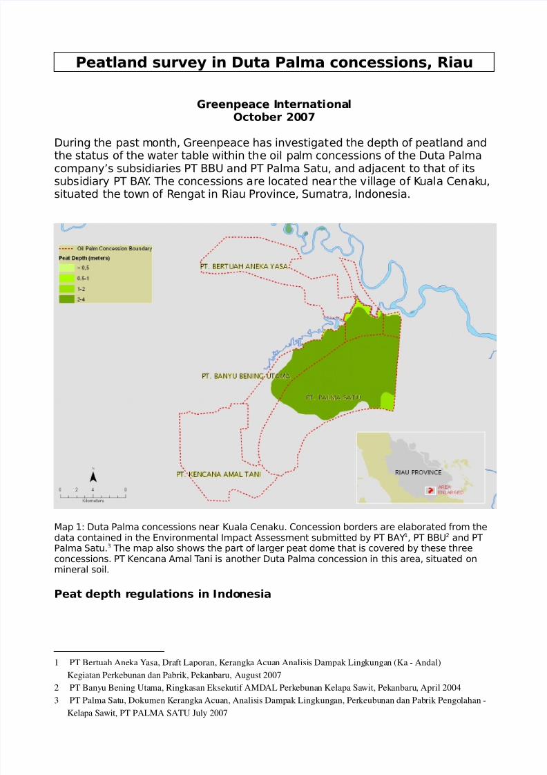
Peatland survey in Duta Palma concessions, Riau Greenpeace I nternati ona l October 20 07 During the past month, Greenpeace has investigated the depth of peatland and the status of the water table within the oil palm concessions of the Duta Palma company’s subsidiaries PT BBU and PT Palma Satu, and adacent to that of its subsidiary PT B! " # The concessions are located near the v illage o f $ uala %ena&u, situated the town of 'engat in 'iau Province, Sumatra, (ndonesia# )ap *+ Duta Palma concessions near $uala %ena&u# %oncession borders are elaborated from the data contained in the nvironmental (mpact !ssessment submitted by PT B!" * , PT BBU - and PT Palma Satu# . The map also shows the part of larger peat dome that is covered by these three concessions# PT $encana !mal T ani is another Duta Palma concession in this area, situated on mineral soil# Peat depth r egulations in Indonesia 1 PT Bertuah Ane ka Y asa, Dra ft Laporan, Kerangk a Acua n Analisi s Dampak Ling kunga n (Ka - Andal) Kegiatan Perkebunan dan Pabrik, Pekanbaru, August 2007 2 PT Bany u Bening Uta ma, Ringka san Eksek utif AMD AL Perk ebuna n Kelapa Sa wit, Pek anbaru , April 2004 3 PT Palma Sat u, Dokumen Kerangk a Acuan, Analis is Damp ak Lingkung an, Per keubu nan dan Pab rik Pengo lahan - Kelapa Sawit, PT PALMA SATU July 2007
During the past month, Greenpeace has investigated the depth of peatland andthe status of the water table within the oil palm concessions of the Duta Palmacompany’s subsidiaries PT BBU and PT Palma Satu, and adacent to that of itssubsidiary PT B!"# The concessions are located near the village of $uala %ena&u,situated the town of 'engat in 'iau Province, Sumatra, (ndonesia#
)ap *+ Duta Palma concessions near $uala %ena&u# %oncession borders are elaborated from thedata contained in the nvironmental (mpact !ssessment submitted by PT B!"*, PT BBU- and PTPalma Satu#. The map also shows the part of larger peat dome that is covered by these threeconcessions# PT $encana !mal Tani is another Duta Palma concession in this area, situated onmineral soil#
Peat depth regulations in Indonesia
1 PT Bertuah Aneka Yasa, Draft Laporan, Kerangka Acuan Analisis Dampak Lingkungan (Ka - Andal)
Kegiatan Perkebunan dan Pabrik, Pekanbaru, August 20072 PT Banyu Bening Utama, Ringkasan Eksekutif AMDAL Perkebunan Kelapa Sawit, Pekanbaru, April 2004
!rticle */ of the (ndonesian Presidential Decree of -0 1uly *22/ on )anagementof Protected !rea 3 4o .- specifies that, 5upstream swamp and peatlands deeperthan three metres should be protected#5
!ccording to a *266 decree by the )inistry of 7orestry and Plantations concern3ing criteria for choosing areas for palm oil plantations,8 5plantation developments
on peat soils deeper than two metres are not allowed#5
The development of plantations on peatland deeper than two metres has,therefore, effectively been illegal since *226 and peatlands deeper than threemetres should have been protected under (ndonesian law since *22/#
Peatland depth survey of October 2007 in Duta Palma concessions
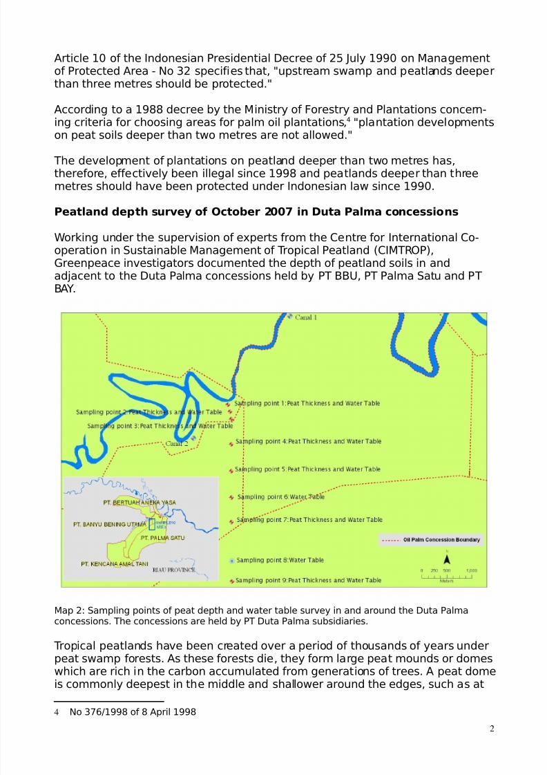
9or&ing under the supervision of e:perts from the %entre for (nternational %o3operation in Sustainable )anagement of Tropical Peatland ;%()T'<P=,Greenpeace investigators documented the depth of peatland soils in andadacent to the Duta Palma concessions held by PT BBU, PT Palma Satu and PTB!"#
)ap -+ Sampling points of peat depth and water table survey in and around the Duta Palmaconcessions# The concessions are held by PT Duta Palma subsidiaries#
Tropical peatlands have been created over a period of thousands of years underpeat swamp forests# !s these forests die, they form large peat mounds or domeswhich are rich in the carbon accumulated from generations of trees# ! peat domeis commonly deepest in the middle and shallower around the edges, such as at
Starting from the river, Greenpeace investigators measured the depth of thepeat soil from outside the concession areas through the PT BBU concession,running close to and parallel to the PT B!" concession and a short way into arecently allocated concession controlled by PT Palma Satu#0 The transect is
shown in )ap -# The transect was selected to cover the conditions in a largepeat dome covered by all three subsidiaries’ concessions# This had previouslybeen mapped by 9etlands (nternational and showed a peat depth of two to fourmetres#?
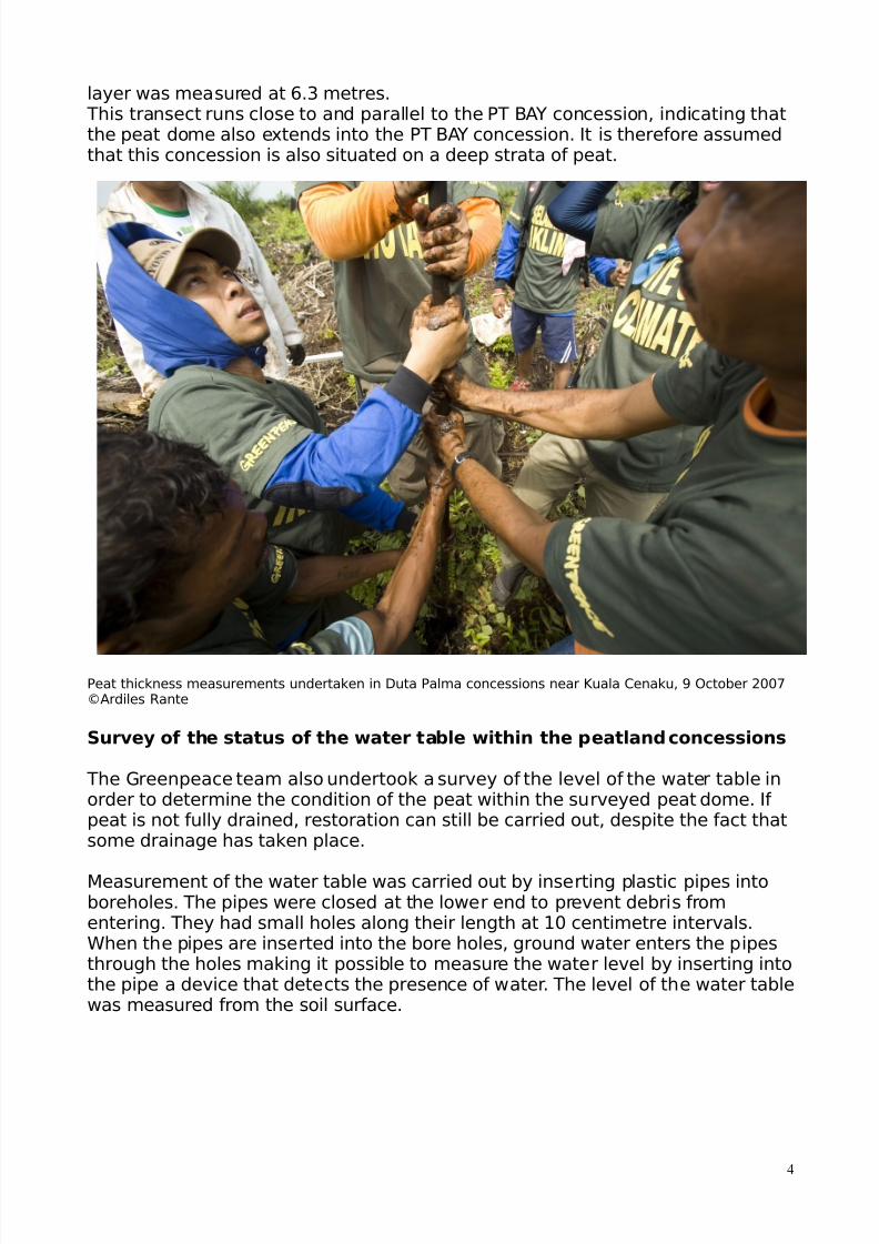
The thic&ness or depth of the peat layer was measured by inserting into the peatsoil a *0 centimetre bit3peat drill fi:ed to a two3metre long handle, until mineralsoil was encountered# 9here the peat was very deep, the drill handle could beelongated to a ma:imum length of eight metres, if necessary# 9hen the drill hitmineral soil, it was rotated to ta&e a sample core# %ores were then ta&en fromthe entire length of the drill to enable analysis of the sample and accuratemeasurement of peat depth#
indings of the peat depth investigation
The main finding of the investigation is that the Duta Palma concessions lie onvery deep strata of peat, ranging from .#0 metres outside the boundary of theconcession> up to more than 6 metres deep in the middle of the concessionarea#6
Sampling point no ;)ap-=
Distance from the%ena&u 'iver ;m= Peat thic&ness ;m=
Table *+ 'ecord of peat depth at sampling points from the river into the concessions#
The peat thic&ness at the river was appro:imately /#?2 metre# !t the PT BBUconcession border, the depth was .#60 metres which became deeper further intothe concession# !t a distance of 0// metres inside this concession the peatdepth was >#0 metres and at two &ilometres from the PT BBU border, the peatlayer was found to be more than eight metres deep# The full depth of the peatcould not be measured because the ma:imum e:tension of the drill was limitedto eight metres# !t .#8 &ilometres from the river, ust outside the PT BBUboundary and into the PT Palma Satu concession boundary, the depth of the peat
5 The boundaries used here for this concessions are based on the nvironmental (mpact !ssessment filed by PT
Palma Satu in 1uly -//> ;Do&umen $erang&a !cuan !nalisis Dampa& Aing&ungan Per&ebunan dan Pabri& Pengolahan$elapa Sawit# PT Palma Satu, 1uly -//>=
6 Wahyunto et. al (2003). Maps of Area of Peatland Distribution and Carbon Content in Sumatera !""0 # 2002.Wetlands $nternational % $ndonesia Pro&ramme ' Wildlife abitat Canada (WC).
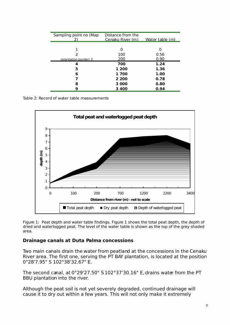
Total peat depth Dry peat depth Depth of waterlogged peat
7igure *+ Peat depth and water table findings# 7igure * shows the total peat depth, the depth of
dried and waterlogged peat# The level of the water table is shown as the top of the grey shadedarea#
Drainage canals at Duta Palma concessions
Two main canals drain the water from peatland at the concessions in the %ena&u'iver area# The first one, serving the PT B!" plantation, is located at the position/-6C>#205 S */-.6C.-#?>5 #
The second canal, at /-2C->#0/5 S */-.>C./#*?5 , drains water from the PTBBU plantation into the river#
!lthough the peat soil is not yet severely degraded, continued drainage willcause it to dry out within a few years# This will not only ma&e it e:tremely
vulnerable to fire but the simple e:posure to o:ygen will start the decompositionprocesses and cause carbon in the dry peatland to o:idise and be released to theatmosphere as carbon dio:ide#
indings of the *ater table investigation
The water table measurements carried out at the Duta Palma oil palm plantationconcession near the village of $uala %ena&u reveal that the water table is stillclose to the surface, at a depth of between *#.? and /#>6 metres ;see Table -and 7igure *=# !ccording to e:perts from %()T'<P, this demonstrates that thepeat is still largely wet and not yet severely compromised, indicating that thepeatland could be restored#
(f drainage continues, however, this peat dome will be severely degraded andbeyond restoration in a few years#
Implications of the findings
The Greenpeace investigation shows that the peatland on which Duta Palma’ssubsidiaries hold oil palm concessions is much deeper than two metres and aretherefore not allowed to be developed into oil palm plantations#2
7urthermore, the concessions lie on peat deeper than three metres and,according to a Presidential Decree from *22/, should be protected#
)aps compiled by 9etlands (nternational as a basis for provincial land3useplanning,*/ showed this area as having a peat depth of two to four metres# <ur
investigation showed it to be much deeper, reaching over eight metres in someareas# !lthough these maps are currently the best available, our surveydemonstrates that they are not sufficiently detailed to serve as a basis forprovincial land3use planning
Drainage of tropical peatland to one metre depth results in emissions of 6/3*//tonnes of carbon dio:ide ;%<-= per hectare per year, e:cluding the effects offire#** (n large parts of the peat dome under Duta Palma’s concessions, thedrainage depth has already reached one metre# This could lead to *#0 milliontonnes of %<- being emitted per year, eFuivalent to the annual %<- emissionsfrom .>0,/// average !ustralian cars#*- 7urther drainage of this area is e:pected
to dramatically increase emissions, given the peat depth of eight metres#
The company Duta Palma is already in conflict with local communities and isdestroying the habitat of endangered animals# (n addition, its operations are
9 )inisterial Decree of the )inistry of 7orestry and Plantations, criteria for choosing areas for Palm oil plantations,
4o .>?@*226 of 6 !pril *226, 5plantation developments on peat soils deeper than two metres are not allowed5#
10 9ahyunto et# al ;-//.=# )aps of !rea of Peatland Distribution and %arbon %ontent in Sumatera, *22/ -//-#
11 Hooier, !#, Silvius, )#, 9Isten, H# and Page, S# -//?# P!T3%<-, !ssessment of %<- emissions from drained
peatlands in S !sia# Delft Hydraulics report J.28. ;-//?=
12 %ar eFuivalents+ The average distance driven per year is generally assumed to be *0,/// &m in !ustralia and theaverage fuel consumption is estimated in the 4ational Greenhouse Gas (nventory ;4GG(= to be about *- litres per *//&m which is eFuivalent to *,6// litres per year# !ccording to the 4GG( 9or&boo& .#*, each litre of automotive gasoline;i#e# petrol= burned in an average car produces -#-88 &g of %<-# Therefore the average car produces about 8 tonnes of%<- per year#
creating enormous emissions of greenhouse gases# Duta Palma is a member ofthe 'oundtable on Sustainable Development ;'SP<=#
4onetheless, because the water table is still relatively high it is not too late torestore the integrity of these particular peatlands#
/ call to action
Greenpeace is calling on Duta Palma to stop the drainage of this peatland andunderta&e restoration and replanting of the forest that it has destroyed indisregard of Presidential and )inisterial Decrees meant to protect such areas#
Greenpeace is calling on the (ndonesian government to+
• commit to a moratorium on deforestation and industrial loggingK
• commit to a review of laws, governance and law enforcementK
• implement a responsible and ust land3use planning system#
(n the run3up to the $yoto Protocol meeting in Bali, in December, Greenpeacewants the (ndonesian government to commit to a moratorium on conversion anddestruction of (ndonesian peatland forests and ensure the implementation of aneffective action plan against forest fires#