Peatlands and the Historic Environment Ben Gearey 1 , Norá Bermingham 1 , Henry Chapman 1 , Dan Charman 2 , William Fletcher 3 , Ralph Fyfe 4 , Jamie Quartermaine 5 , Robert Van de Noort 2 Scientific Review December2010 A Bronze Age axe discovered during peat cutting on Orkney (Photo: Frank Bradford) 1 University of Birmingham 2 University of Exeter 3 English Heritage 4 University of Plymouth This review was commissioned by the IUCN UK Peatland Programme‟s Commission of Inquiry on Peatlands. The IUCN UK Peatland Programme is not responsible for the content of this review and does not necessarily endorse the views contained within.
Transcript
Peatlands and the Historic Environment
Ben Gearey1, Norá Bermingham1, Henry Chapman1, Dan Charman2, William Fletcher3, Ralph Fyfe4, Jamie Quartermaine5, Robert Van de Noort2
Scientific Review December2010
A Bronze Age axe discovered during peat cutting on Orkney (Photo: Frank Bradford) 1 University of Birmingham
2 University of Exeter
3 English Heritage
4 University of Plymouth
This review was commissioned by the IUCN UK Peatland Programme‟s Commission of Inquiry on Peatlands. The IUCN UK Peatland Programme is not responsible for the content of this review and does not necessarily endorse the views contained within.
REVIEW Peatlands and the Historic Environment
2
Contents List of Figures and Tables 3
1. Introduction 5 2. Background: peatlands and the historic environment record 6 3. Summary of the known and estimated heritage resource in UK peatlands 6 3.1 Working definitions 7 3.2 Sources of archaeological data for peatlands 10 3.3 Quantifying the archaeological resource in peatlands in the UK 10 3.4 Summary 11
4. The Nature of the Historic Environment Record of Peatlands: Overview 11 4.1 Categories of peatland archaeology and palaeoenvironments 16 4.2 Summary 17
5. Current gaps in knowledge 17 5.1 Spatial and temporal gaps 19 5.2 Filling in the gaps: finding sites 20 5.3 Understanding preservation of the archaeological and palaeoenvironmental resource 20 5.4 Collating and analysing available datasets 20 5.5 Public perception and understanding 21 5.6 Summary 22
6. Risk and threat 22 6.1 Introduction 23 6.2 Erosion 24 6.3 De-watering 25 6.4 Afforestation 26 6.5 Peat Extraction 26 6.6 Burning 27 6.7 Climate change 27 6.8 Development 28 6.9 Other threats: access and military impact 28 6.10 Summary 28
7. Protection of the peatland historic environment 28 7.1 Introduction 29 7.2 Legislation and guidance 30 7.3 Resources and practice 31 7.4 Enhancing protection 31 7.5 Summary 32
8. Conflicts and consensus: management priorities for the historic environment
of peatlands 33 9. Conclusions 37 Acknowledgements 37 References 37
REVIEW Peatlands and the Historic Environment
3
List of Figures and Tables Table 1.1 Respondents to the stakeholder survey 4 Figure 2.1 Conserved part of the Sweet Track 5 Figure 2.2 Lindow Man 5 Figure 2.3 Estimated percentage survival of different archaeological materials in dryland (left) and wetland (right) environments 6 Figure 3.1 A machine-cut peat face from a lowland peatland 7 Figure 3.2 Upland blanket peat on Langdale Moor, Cumbria, displaying erosion scars 7 Table 3.1 Peatland archaeological surveys and research in the United Kingdom 7 Figure 3.3 Locations of the major archaeological surveys of England‟s wetlands 9 Figure 4.1 Cuthill Stone Row, Dartmoor, dating to the Neolithic 12 Figure 4.2 Bronze Age cist within the blanket peat on White Horse Hill, Dartmoor 12 Figure 4.3 Late Neolithic trackway and platform on Hatfield Moors, South Yorkshire 13 Figure 4.4 Examples of common types of sub-fossils preserved in peat 15 Figure 5.1 Peat cutting on Gildleigh Common, Dartmoor in 1983 18 Figure 5.2 GIS generated model of the age of the surviving peat surface of the lowland raised mire of Hatfield Moors, South Yorkshire 19 Table 6.1 Threats to UK peatlands and the historic environment record 22 Figure 6.1 Birch bark roll and barbed red deer antler point dating to around 8000BC from Star Carr, North Yorkshire 25 Figure 6.2 One of the 21 red deer antler perforated part-skulls from Star Carr, North Yorkshire, thought to have been used as a headdress around 8000BC 25 Figure 6.3 Aerial view of Fylingdales Moor following the fire of 27 Figure 6.4 Example of prehistoric rock art on Fylingdales Moor exposed as a result of the fire of 2003 27 Table 7.1 Active legislation, policy and guidance in the UK 29 Table 7.2 Relevant Research Frameworks & Strategies in the UK 30
REVIEW Peatlands and the Historic Environment
4
1. Introduction This report is one of a series of technical reviews commissioned by the IUCN and aimed at presenting our current state of knowledge of the historic environment of peatlands in the UK. In addition to a literature review, it draws on information provided in response to a questionnaire circulated to a sample of historic environment and palaeoecological specialists drawn from curatorial, commercial and academic sectors. Though the number of respondents was relatively small (N=30), they represented the range of sectors targeted (Table 1.1). The stakeholder survey posed six questions: Are you aware of recent work and/or revision of data on the peatland historic
environment within your region? What gaps in our knowledge of the historic environment & peatlands have you identified? What do you perceive as the cultural value of peatlands? What are the risks to the peatland historic environment? Where do we need to strengthen policy and what practice guidance do we need? Who do you currently collaborate with (e.g. agency, institute) and who would you like to
work with in the future? Table 1.1 Respondents to the stakeholder survey
Category of organisation Name of organisation
Public Bodies Environment Agency – Environment Centre Wales Northern Ireland Environment Agency Historic Scotland English Heritage CADW
Association of Local Government Archaeological Officers (ALGAO UK) Aberdeenshire Council Shetland Amenity Trust Somerset County Council Stirling Council
Higher education Universities of Aberdeen, Birmingham, Stirling, Queen‟s University Belfast, Wales (Lampeter)
Nature Conservation Trusts Yorkshire Wildlife Trust Royal Society for the Protection of Birds
National Park Authorities Exmoor, Dartmoor, The New Forest, Yorkshire Dales and the Broads Authority
Research Institutes Macaulay Land Use Research Institute
Private sector Various independent consultants
The report provides an introduction to the reasons why peatlands are important for the historic environment. It summarises research undertaken in the last 50 years and considers where the gaps in our current knowledge lie. It considers the different categories of threat to peatlands and the impacts these may have on archaeological remains (sites and finds), including their vulnerability to climate change. The value of peatlands as archives preserving records of past environmental changes is also presented and the contribution such data can make to future management and conservation issues highlighted. It considers the vulnerability of the unique and finite historic environment resource of peatlands and outlines current and future threats. The report then offers an overview of relevant legislation, policies and guidance for the protection and management of the historic environment in peatlands, noting that legislation alone cannot prevent damage to peatlands. Finally, the report considers the harmonies and conflicts between the different interests that have a stake in the management of peatlands in the UK and. It concludes that, whilst areas of potential conflict exist, best practice management of peatlands as historic environments aims for the same
REVIEW Peatlands and the Historic Environment
5
objective: a peatland that is a living, wet and flourishing ecosystem. This offers the best protection for both the historic environment record and the palaeoenvironmental archive sealed beneath and within the peat.
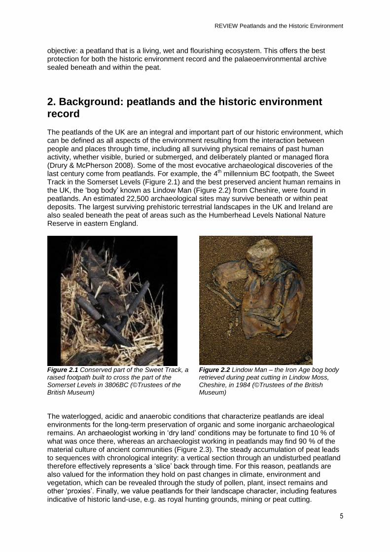
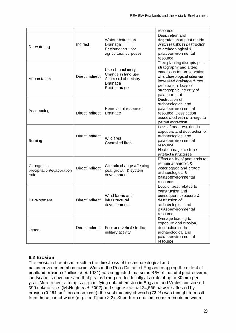
2. Background: peatlands and the historic environment record The peatlands of the UK are an integral and important part of our historic environment, which can be defined as all aspects of the environment resulting from the interaction between people and places through time, including all surviving physical remains of past human activity, whether visible, buried or submerged, and deliberately planted or managed flora (Drury & McPherson 2008). Some of the most evocative archaeological discoveries of the last century come from peatlands. For example, the 4th millennium BC footpath, the Sweet Track in the Somerset Levels (Figure 2.1) and the best preserved ancient human remains in the UK, the „bog body‟ known as Lindow Man (Figure 2.2) from Cheshire, were found in peatlands. An estimated 22,500 archaeological sites may survive beneath or within peat deposits. The largest surviving prehistoric terrestrial landscapes in the UK and Ireland are also sealed beneath the peat of areas such as the Humberhead Levels National Nature Reserve in eastern England.
The waterlogged, acidic and anaerobic conditions that characterize peatlands are ideal environments for the long-term preservation of organic and some inorganic archaeological remains. An archaeologist working in „dry land‟ conditions may be fortunate to find 10 % of what was once there, whereas an archaeologist working in peatlands may find 90 % of the material culture of ancient communities (Figure 2.3). The steady accumulation of peat leads to sequences with chronological integrity: a vertical section through an undisturbed peatland therefore effectively represents a „slice‟ back through time. For this reason, peatlands are also valued for the information they hold on past changes in climate, environment and vegetation, which can be revealed through the study of pollen, plant, insect remains and other „proxies‟. Finally, we value peatlands for their landscape character, including features indicative of historic land-use, e.g. as royal hunting grounds, mining or peat cutting.
REVIEW Peatlands and the Historic Environment
6
Identification and presentation of such inheritance can benefit local economies through the development of associated tourism.
Figure 2.3 Estimated percentage survival of different archaeological materials in dryland (left) and wetland (right) environments (after Coles 1986). NB. In the context of this diagram, „wetland‟ can be taken as equivalent to peatland
3. Summary of the known and estimated heritage resource in UK peatlands
Key stakeholder comment: “Archaeological surveys of peatland are not common here [Scotland] at present.”
3.1 Working definitions
The extent and nature of the peatlands in the UK has been defined by Shepherd et al. (2010) as “…areas of land where the majority of land has been subject to the accumulation of Quaternary surface deposits with a peaty texture under waterlogged conditions, or areas currently supporting peat-forming vegetation.” A further distinction between shallow and deep peaty soils has been set artificially at 40 cm of peaty material for England and Wales, or 30 cm when found directly over rock or at 50 cm for Scotland. Therefore, this report includes peat soils in raised bogs and fens as well as blanket bogs in both upland and lowland contexts (Figures 3.1 & 3.2). Although we are aware of more specific definitions of peat-type on the basis of vegetation, hydrology or nutrient status (Charman 2002), for the purposes of this document, the phrase „peatland‟ will be used collectively for both upland and lowland areas.
REVIEW Peatlands and the Historic Environment
7
Figure 3.1 A machine-cut peat face from a lowland peatland. The complex stratigraphy of the peatland is clearly visible (Photo: N. Bermingham)
3.2 Sources of archaeological data for peatlands Sources of information for the historic environment of peatlands in the UK are substantially those which are available for the archaeological resource in general and are held in the National Monuments Record (NMR). In England, English Heritage is responsible for the NMR whist the Royal Commission on the Ancient and Historical Monuments of Scotland (RCAHMS) manages the National Monuments Record of Scotland (NMRS). Similarly in Wales, the National Monuments Record of Wales (NMRW) is held by the Royal Commission on the Ancient and Historical Monuments of Wales (RCAHMW). In Northern Ireland, this responsibility lies with the Northern Ireland Environment Agency and Department of Built Heritage. Local records, known as Sites and Monuments Records (SMRs) or Historic Environment Records (HERs) are held by public bodies throughout the UK. These records list the location, type and period of a given archaeological site, along with a brief description and information on more detailed sources of information such as site reports and other publications. In England, Scotland & Wales, these records are typically held by County Councils, District Councils, National Parks or Unitary Authorities. In Northern Ireland, records include the Northern Ireland Site & Monuments Record (NISMR) and Monuments & Buildings Record (MBR). These sources have not been interrogated in detail for this report, but available summaries of the data have been consulted. Other information is available from field survey, research projects and other related initiatives. Table 3.1 illustrates the major field surveys, syntheses and other research projects concerned with the historic environment of peatlands in the UK, though the table is not comprehensive. It also includes desk top surveys and ecological or biodiversity projects most relevant to the archaeological and palaeoenvironmental peatland resource, many of which are ongoing.
Table 3.1 Peatland archaeological surveys and research in the United Kingdom
Large scale field surveys
Research Projects Other
England North West Wetlands Survey (1990-1998) Fenland Survey (1981-1995)
Monuments at Risk in England‟s Wetlands (2002) Monuments at Risk in Somerset‟s Peatlands
Peatscapes Yorkshire Peat Project MIRE Project Exmoor
Project (Somerset County Council- Brunning et al., forthcoming) Predictive Modelling of Archaeological Site Locations in Raised Mires (Univ. of Birmingham, EH) Upland Peat Projects (EH) (see also Quartermaine et al. 2007)
Mires on the Moors
Scotland - Scottish Natural Heritage: A historical background of Flanders Moss (2003) No. 002 (ROAME No. F02LG22). Wetland Archaeology: Carse of Stirling Archaeological Assessment (AOC 1999; see also Ellis 2001)
N. Ireland - - Peatland archaeology in Northern Ireland: an evaluation (Plunkett & Foley 2006) Condition and management survey of the archaeological resource in Northern Ireland. (Gormley et al. 2009)
Wales The Uplands Archaeology Initiative (RCAHMW) 1990‟s-present Funerary & Ritual Project (Evans, 2006)
- -
England has benefitted from English Heritage (EH) funded surveys of the four largest areas of lowland peatlands in England (the Northwest Wetlands Survey, the Humber Wetlands Project, the Somerset Levels Project and the East Anglian Fenland Project: referred to collectively as the EH Wetland Surveys) (Figure 3.3). These provide significant information on the historic environment record of these peatlands, although our knowledge is mediated by variations in survey methodologies: for example in the case of the Somerset Levels (SSL) Project, 100 % of the area of exposed surface peat was visited once (c. 25 % of the area shown in Figure 3.3), of which the 8-9 % of the levels affected by peat extraction was visited
REVIEW Peatlands and the Historic Environment
9
on numerous occasions. For the Fenlands Survey, 60 % of the areas were investigated by fieldwalking once only. Little excavation was carried out by the North West Wetlands Survey (NWWS) and hence there is no information available on the state of preservation of any archaeological remains in these peatlands. The total spatial remit of these EH Wetland Surveys was 887k ha, although the actual area studied in the field has been estimated at about 4450k ha (Van de Noort et al. 2002). A number of assessments of the current status and future management of wetlands in England followed (e.g. Coles 1995; Van de Noort et al. 2002; Olivier & Van de Noort 2002).
Figure 3.3 Locations of the major archaeological surveys of England‟s wetlands
Desktop surveys of both archaeological and palaeoenvironmental resources in Scotland have been carried out by Historic Scotland (see SWAP & SPAD) but no national surveys have been carried out. The Scottish Wetland Archaeology Project (SWAP) produced a research agenda for work in Scottish wetlands (defined as lacustrine and peatland systems) with the aim of identifying „candidate sites for … major excavation‟ and raising the profile of wetland archaeology in the country (Cavers 2006). Little concerted research has been carried out on the archaeological resource of Welsh peatlands, although extensive bibliographies of palaeoenvironmental projects which include work in these areas have been compiled and can be accessed on the Research Framework for the Archaeology of Wales web-site (http://www.archaeoleg.org.uk/intro.html). Although there have not been specific projects to investigate upland peat deposits, structures visible within peat will have been recorded, as will the palaeoenvironmental potential of sites and areas of peat cutting. The Uplands Archaeology Initiative was set up by the Royal Commission in the 1990s and includes some palaeoenvironmental studies as well as aerial photographic mapping and field walking of the peat deposits of the uplands. In addition, the CADW-funded „Funerary & Ritual Project‟ (Evans 2006), included an extensive survey of prehistoric monuments in the Welsh uplands and further palaeoenvironmental work.
3.3 Quantifying the archaeological resource in peatlands in the UK Quantifying the archaeological resource within the peatlands of the UK is problematic. Van de Noort et al. (2002) utilised the results of the Wetland Surveys alongside other SMR data sources to estimate monument density and distribution within peatlands. Whilst these estimates are useful in determining the potential quantity of the resource they of necessity, rely on a number of uncertain and untested assumptions regarding site distribution. This is illustrated by the relative densities of sites identified by the NWWS compared with that of the SSL. For the former, an overall density of less than one site per km² was recorded, of which just 23 of the 253 sites (9 %) were described as „wet preserved‟. This was interpreted as reflecting the dominant pastoral agricultural regime in the NWWS area which restricted the potential to locate sites. In contrast, the results from the Somerset Levels Survey of the Brue Valley and Sedgemoor revealed a significantly higher density of 3.4 sites per km², of which 59% were „wet-preserved‟, reflecting their discovery through peat extraction. However, the vast majority of these sites were prehistoric in date, reflecting the loss of more recent remains through peat cutting. Van de Noort et al. (2002) used data from the Wetland Surveys to estimate a figure of at least 1.2 monuments per km² in lowland peatlands in England, equating to an overall estimate of around 4,200 monuments in England alone, of which a significant proportion were described as likely to be wet-preserved. However, it was noted that if the figures determined by the Somerset Levels Project for the Brue valley were used, then the estimated number of sites in lowland peatlands in England would be in excess of 7,000. A monument density of at least 2.2 monuments per km² was calculated for upland peatlands, providing an estimate of over 1,800 sites in England alone. In Northern Ireland, a desktop study in 2003 of sites from peatlands recorded 1002 archaeological sites and 763 registered „finds‟ from in or beneath peat deposits. It also concluded that the numbers of finds by county were disproportionate, with the vast majority coming from Antrim and Londonderry, reflecting the 19th century work by the Ordnance Survey and by antiquarian investigations in these areas (Plunkett & Foley 2006). In a more recent survey of the archaeological resource in Northern Ireland, over 12 % of archaeological sites in Northern Ireland were identified in wetland contexts, although no distinction was made between peatlands (as defined by the IUCN) and other types of wetland (Gormley et al. 2009). Currently, the Northern Ireland Sites and Monuments Record lists 222 archaeological sites and monuments associated with peatlands. While the SWAD does not provide definitive figures on the number of recorded archaeological sites in Scottish peatlands, its database lists 365 entries of interest in raised mires with a further 2,238 entries for „peaty soils‟. These figures provide some indication of the archaeological resource within Scottish peatlands. Similarly, the SPAD lists almost 800 entries relevant to palaeoenvironmental research in Scottish peatlands, most of which pertain to raised mires.
3.4 Summary Whilst estimates have been produced on the basis of past survey and study, there are no definitive data on the actual number of archaeological sites in the peatlands of the UK. The available figures reflect land-use and the implications of this for archaeological visibility and hence the focus of subsequent investigation. The existing data are derived very much from „hot-spots‟ of such research (i.e. The Somerset Levels), the wider applicability of which is unclear. There are very few comparative figures from outside of the UK. The most intensively investigated lowland peatlands are in the Republic of Ireland, where survey by the Irish Archaeological Wetland Unit identified 3,462 sites in 45,000 ha of raised mire. This
REVIEW Peatlands and the Historic Environment
11
equates to 7.7 sites per km² (McDermott 2007), a considerably higher figure than the estimate by Van de Noort et al. (2002) of 1.2 sites per km² for English lowland peatlands. The concentration of sites in any given region is the product of 10 millennia of human activity, which would have resulted in spatial and temporal variation. The following section considers case studies outlining in more detail the character of the historic environment record of peatlands in the UK.
4. The Nature of the Historic Environment Record of Peatlands: Overview As highlighted in the previous section, knowledge and understanding of the historic environment record of the peatlands of the United Kingdom is highly variable. England is the only one of the nations to have benefitted from large scale, integrated investigation of the lowland peatland resource in the form of the EH Wetland Surveys (Section 3, Table 3.1, Figure 3.3). Additionally, some of the English peatlands have a long history of study, specifically the Somerset Levels and the Humberhead Levels. Archaeological interest in the lowland mire complex of Hatfield Moors, for example, began in the seventeenth century with the work of Abraham De la Pryme (1671-1704) who postulated a number of interpretations regarding the landscape as well as recording bog-oaks, Roman coins, and a bog body (Turner 1995). In addition to these inconsistencies, the nature of study has varied considerably. For example, some areas have received greater proportions of palaeoenvironmental study than others, such as the uplands of the North York Moors and Dartmoor (e.g. Simmon 2003), Cumbria (Barber et al. 1994; 1998) and the lowlands of the Humberhead levels (e.g. Whitehouse et al. 2001). In contrast, peatlands within areas such as Staffordshire and Northern Ireland have seen considerably less palaeoenvironmental investigation.
4.1 Categories of peatland archaeology and palaeoenvironments There are four distinct categories of the historic environment resource of peatlands:
1. Sub-peat archaeology; 2. Archaeological remains contained within the peat matrix itself; 3. Archaeological remains located on the surface of the peat; 4. The palaeoenvironmental record preserved within the peat.
It is possible for all four of these categories to be represented at a single site and hence they are not mutually exclusive. There is evidence for spatial variation in each of these certain categories; for example, identified archaeological sites within the peat (2) tend to be located in lowland rather than upland contexts, largely reflecting discoveries related to peat extraction in the former areas. It is also important to note that all peat deposits have some value in palaeoenvironmental terms (4), irrespective of the presence or absence of archaeology. The following section expands on these categories and presents case studies to illustrate each in turn. 4.1.1 Sub-peat archaeology
Case Study 1: Copney stone circles, Northern Ireland This site is a Scheduled Ancient Monument (see Section 7) in State Care Guardianship. Known locally since the 1970s, the complex was scheduled in 1983 and taken into State care in 1990. The stone circles are part of the Mid-Ulster Stone Circle Complex constructed during the Bronze Age (c. 4,300-2,650 yrs before present) on land that was later subsumed
REVIEW Peatlands and the Historic Environment
12
by peat growth. Partial clearance of a thin layer of blanket peat revealed an impressive complex of stone circles typically comprising a central cairn surrounded by in excess of 100 packed uprights stones, forming monuments measuring between 16m and 20m in diameter. Other such prehistoric monuments sealed beneath peat, and discovered during peat cutting, include the Creggandevesky court tomb, Co. Tyrone, N. Ireland (http://www.peatlandsni.gov.uk/archaeology/tombs.htm)
Where peatlands have formed via processes of paludification, entire prehistoric landscapes can be preserved intact beneath the later accumulations of peat (e.g. Mc Cullagh & Tipping 1988). Large monuments such as the Copney Stone Circle Complex, County Tyrone, N. Ireland (Foley & MacDonagh 1998) (See Case Study Box 1), may be preserved in this way, as well as less visible, but no less important, archaeological sites and remains. For example, extensive scatters of worked flint, including a range of flint knives and arrowheads, were exposed in peat scars at Waun Fignen Felen, Brecon Beacons, South Wales, and indicate that this location was a focus for Mesolithic (c. 12,000-6,500 years before present) hunting trips (Berridge 1981). Whilst prehistoric activity tends to be well–represented in upland areas, examples of early historic, medieval and later sites are also known, such as the medieval royal deer park at Kincardine in Aberdeenshire where the remains of a park pale (boundary) that may have been created by William the Lion (1165-1214) are recorded (Gilbert 1979).
4.1.2 Archaeological remains contained within the peat matrix itself This second category reflects sites that were constructed, or artefacts that were deposited, within contemporary areas of peat growth. Probably the best known and certainly the most comprehensively investigated sites of this second category are from the Somerset Levels (Case Study Box 2). Whilst archaeological remains found within peat tend to be made of wood, there are examples of stone structure preserved in this context, such as the recently discovered Neolithic stone row on Cut Hill, Dartmoor (Fyfe & Greeves 2010, Figure 4.1). This monument was exposed by peat cutting and erosion, and is over 200m in length, although the stones themselves were originally situated on the contemporaneous peat surface. A Bronze Age cist was recently discovered within the peat matrix on White Horse Hill, also on Dartmoor (Figure 4.2). There are generally fewer examples of sites from within the peat matrix in upland areas. This partly reflects a spatial bias in knowledge towards the lowlands (see below, Section 5).
Figure 4.1 Cuthill Stone Row, Dartmoor, dating to the Neolithic period (Fyfe & Greeves 2010) Figure 4.2. Bronze Age cist within the blanket peat on White Horse Hill, Dartmoor, located at over 600m above sea level. The site is situated above Neolithic peat and below middle Bronze Age peat deposits (Photo: R. Fyfe)
Case Study 2: The lowlands: the Somerset Levels, England This area is the most important in terms of the recorded peatland archaeological record in England: one quarter of the surviving wet-preserved sites in England are found here and there are more scheduled examples of such sites here than in the whole of the rest of the country combined (Jones et al. 2003). The Sweet Track (Figure 2.1) is only one of a complex of prehistoric sites in this area including the Honeygore, Abbotts Way, Bells, Bakers, Westhay and Nidons trackways. Generally, these wooden trackways reflect the status of the peatland as an obstacle to be crossed or accessed. The Sweet Track is around 2km long and joins the „island‟ of Westhay to the higher ground of Shapwick. Dendrochronological (tree-ring) dating has provided a very precise date for the construction of the site in 3,806 or 3,807 BC (5757-5759 years before present). Sites such as these which are built of wood are particularly vulnerable to a range of threats (see Section 6)
The rich archaeological record of the Somerset Levels can be contrasted with that of the lowland peatlands of Fenns and Whixall Mosses on the Shropshire-Clwyd border, which remain comparatively undisturbed and have thus produced only one Bronze Age axe, a coin and a bog body of unknown date (Coles 1994). However, the archaeological potential of peatlands elsewhere continues to be demonstrated such as by the discovery of a Neolithic timber trackway and platform (Figure 4.3) on Hatfield Moors (Humberhead Levels National Nature Reserve) in 2006. Being a linear monument, part of this site is preserved below the peat (on the pre-peat land surface) whilst the majority of the structure is contained within the peat matrix (Chapman & Gearey in press). Single artefacts representing chance loss or deliberate deposition are also recorded from a number of peatlands, such as the large quantity of archaeological material recovered from the Upper Forth valley in Scotland during peat clearance in the 18th and 19th centuries (Ellis 2001).
Figure 4.3 Late Neolithic trackway and platform on Hatfield Moors, South Yorkshire. The southern end of the site (background) rests on the pre-peat sands, whereas the rest of the site (foreground) lies on earlier peat deposits. The site was preserved by continued growth of the peatland following its construction. NB. The drainage ditch in the centre of the picture demonstrates the impact of peat cutting on the site whilst the wood in the bottom right hand corner of the picture has suffered from desiccation (see Section 6) (Photo: H. Chapman)
REVIEW Peatlands and the Historic Environment
14
Plunkett & Foley (2006) identified 41 trackways in both lowland and upland contexts in their desk-based study of peatland archaeology in Northern Ireland. Of these, only 5 are known to survive including an upland example at Slaghtfreedan, Co. Tyrone dated to the Bronze Age. This demonstrates the potential for the preservation of structures within these peatlands, although significantly less excavation and fewer analyses have been carried out. Similarly, few examples of this form of site are recorded from Scotland although other finds attest to the general potential. A near life-sized figure carved out of alder wood, known as the „Ballachulish Goddess‟ and possibly dating to the Iron Age, was found in the lowland peat of Ballachulish Moss, near Fort William in North West Scotland (Coles 1994-5). Other indirect forms of evidence can be preserved: investigations in the uplands at Loch Farlary, Sutherland, provided rare traces of prehistoric activity in the form of the cut marks of Bronze Age tools on pine roots preserved within the peat. This probably reflects removal of the roots of dead trees uncovered during prehistoric peat cutting, rather than actual clearance of the woodland itself (Tipping 2008). Perhaps the most vivid evidence preserved in peatlands is in the form of human remains, commonly referred to as „bog bodies‟. Lindow Man (Section 2, Figure 2.2) is probably the most famous example, but many other peatlands have produced such remains. For example, six bog bodies are known from Welsh peatlands, including three from the lowland sites of Gifron, Dolfawr Fair and Llyn Mawr (Turner 1995). Most of the known bog bodies were discovered during the late 19th and early 20th centuries, although they continue to be found today and attest the potential for peatlands to preserve direct evidence of past people. 4.1.3 Archaeological remains located on the surface of the peat This includes traces of human activity associated with the contemporary or near contemporary surface of peatlands and often of comparatively recent date. For the purposes of this discussion, this category is restricted to peatlands that have not been stripped down by peat cutting to expose deeper areas of peat in plan. In these instances, the cut-over surface may of course reveal sites which were originally part of the peat matrix. A common form of surface evidence relates to the exploitation of the peat resource itself. Both upland and lowland peatlands have been exploited for fuel, with some evidence such as that from Loch Farlary (4.1.2) suggesting that evidence for peat cutting may be of great antiquity (Tipping et al. 2008). Additionally, features such as modification of peatlands for agriculture, associated evidence of settlement and even the remains of railway tracks for the transportation of cut peat survive in places. These represent more recent, but still significant aspects of the historic environment record. 4.1.4 The palaeoenvironmental record within the peat: ‘long-term ecology’ and guidance for management and restoration
Case Study 3 Human impact on the environment: Waun Fignen Felen, Wales Palaeoenvironmental analyses at the site of Waun Fignen Felen (Smith & Cloutman 1988) were crucial in establishing the relationship between the archaeological record and associated environmental change. The focus of the Mesolithic human activity was a small lake which had formed in limestone bedrock. Pollen analyses and radiocarbon dating of the organic sediments which infilled the lake indicated the local presence of open woodland with areas of open ground that may have been maintained by grazing animals. There is evidence from the 8th millennium before present that the local heathland vegetation was burnt, possibly deliberately by human communities to encourage large game to gather. The use of fire to open up the vegetation may have played a role in the subsequent inception and spread of peat.
REVIEW Peatlands and the Historic Environment
15
The nature of peat formation means that deposits accumulate sequentially over time, hence successive layers of sediment can represent an intact chronological sequence, which in some cases may stretch back to the end of the last Ice Age (c. 10, 000 years before the present) up to the present day. The plant and animal remains (Figure 4.4) preserved within the peat in this manner can therefore provide information regarding environmental changes over long periods of time (e.g. Charman 1994a, b). These palaeoenvironmental studies can be associated with archaeological sites (see Case Study 3) but there is an independent tradition of investigations carried out across the UK specifically to investigate patterns and processes of peatland development in relation to a range of factors including climate change and the impact of human activity on the environment. It has long been recognised that the palaeoenvironmental record can contribute significantly to discussions regarding the current status and future management and conservation of peatlands (Barber 1993). A recent review of historical environmental changes in the uplands states this succinctly: “By providing a critical evidence base for assessing naturalness, disentangling natural and cultural drivers and establishing the limits of acceptable change underpinning ecological thresholds, a historical perspective can be used to test the applicability and sensitivity of baselines and targets derived from short term knowledge.” (Davies 2008, 4).
Figure 4.4 Examples of common types of sub-fossils preserved in peat: a) pollen grain; b) testate amoeba; c) plant macrofossil remains; d) a variety of beetle remains; e) cross-section of wood; e) tephra shard (Photo: G. Plunkett, E. Reilly & I. Stuijts)
The palaeoenvironmental record has played a critical role in understanding patterns and processes of peat growth in uplands and lowlands, with a particular area of research being the role of human activity in the initiation of blanket peat spread. Some authors (e.g. Simmons 2003; Moore 1993; Tallis 1998) have argued that the evidence from a number of upland sites in the UK indicates clearance of the woodland and related agricultural activities by human communities during the mid-Holocene in particular (c. 5,000 years before present) resulted in waterlogging, leaching of nutrients from the soil and the subsequent accumulation of peat. However, palaeoenvironmental study of sites in the Scottish uplands indicates that peat formation is not necessarily related to the impact of human activity, with evidence for blanket peat spread from as early as 8,500 years before present at certain locations in northern Scotland (Tipping 2008; see also Lawson et al. 2007). The identification of climatic
REVIEW Peatlands and the Historic Environment
16
changes using the palaeoenvironmental record of peatlands is another significant area of research (see Case Study 4).
Case Study 4: Holocene palaeoclimates from ombrotrophic peat deposits Hydrological changes in sequences from ombrotrophic (i.e. rain fed) peatlands are a long established source of data regarding Holocene climate (e.g. Barber 1981). Analyses of testate amoebae and peat humification from May Moss, North York Moors for example, suggest a series of fluctuations between wetter/colder and drier/warmer conditions between c. 1,500 and 300 years before present (Chiverell 2001). Similar research on upland peats in the Templemoss Hills, south-east Scotland has identified a series of „major wet shifts‟ during the Holocene that are replicated in analyses from the lowland site of Walton Moss, Cumbria, suggesting that peatland palaeoenvironmental records can be sensitive records of regional climatic fluctuation (Langdon et al. 2003). Charman (2010) has recently summarised the evidence for a series of at least 9 synchronous changes across the British Isles. As well as providing information regarding the past climate system, these data can assist in understanding how peatland systems may respond to future climatic fluctuations.
Palaeoenvironmental analyses can provide information regarding the long term trajectories of vegetation communities. Such data have implications for understanding aspects of biodiversity, conservation and management of peatlands (see Littlewood et al. 2010). Chambers et al. (2007) used palaeoenvironmental data from two sites (see Case Study 5) in upland Wales to investigate fluctuations in peat forming vegetation, providing valuable data to support current conservation strategies aiming at reducing the dominance of Molinia caerulea (Marrs et al. 2004). Other studies have used pollen and macrofossil analyses to investigate similar changes in peat building vegetation in lowland raised mires (Hughes et al. 2007, see Case Study 5), demonstrating the complex relationship of peatlands to natural and human-induced environmental changes. Sub-fossil insect remains (e.g. Whitehouse et al. 2008) have also been used to investigate long term changes in peatland ecosystems.
Case Study 5: Palaeoenvironmental perspectives on peatland management and conservation Chambers et al. (2007) carried out multi-proxy analyses (plant macrofossils, pollen, charcoal with dating provided by radiocarbon and the record of spheroidal carbonaceous particles) of sequences of blanket mire at the sites of Hirwaun Common and Mynydd Llangatwg (mid and south Wales). The results indicated that blanket mire degradation including the replacement of Sphagnum imbricatum by Molinia caerulea was related to changes in atmospheric inputs and grazing pressures in the post-industrial revolution period. There is evidence that burning was a factor in vegetation change at Mynydd Llangatwg. The conclusions indicate that future strategies for restoration should include: modifying grazing regimes, reduction of burning and pollution and measures aimed at promoting hydrological stability. Hughes et al. (2007) demonstrated that the decline of Sphagnum austinii in peatlands in Wales and Ireland was closely associated with palaeoecological evidence for woodland clearance and land-use intensification over the last 200 years. It is suggested that this decline may be related to a complex of factors including hydrological change and the deposition of dust particles, with Nitrogen loading possibly a critical factor controlling the growth of S. austinii.
4.2 Summary
This section has provided a brief overview of the diverse character of the historic environment record of peatlands in the UK. Many lowland peatlands in particular have been substantially cut-over and often the „significant‟ archaeological finds in peatlands have
REVIEW Peatlands and the Historic Environment
17
tended to be the result of chance discoveries during or following peat extraction, whilst others have been revealed following erosion or farming. Anecdotal evidence suggests that many other sites have been destroyed prior to recording. Many such archaeological sites, especially organic remains are unique to peatlands and are rarely, if ever, encountered in „dryland‟ contexts. Palaeoenvironmental research provides contextual information for archaeological sites, but is also a critical link between past and present processes in peatlands and for investigating the recursive relationship between humans and their environment. These data provide important information with the potential to inform current peatland management and conservation, that to date have arguably not always been effectively integrated into such agendas. The unique character of the historic environment record of peatlands presents a number of challenges to current understanding and these „gaps in knowledge‟ will be considered in the next section.
5. Current gaps in knowledge Absence of evidence of archaeological sites and finds from peatlands does not imply evidence of their absence. Indeed, this represents a well-recognised paradox of the historic environment of peatlands: sites such as trackways, and finds such as bog bodies, are only identified when a peatland is damaged or eroding. When archaeological remains are found in such circumstances, these are exposed to oxygen. Inevitably, this means that their state of preservation will be adversely affected. Where mires are healthy and peat-producing, archaeological sites and finds are well protected and continue to benefit from the anoxic burial environment, meaning that organic archaeological remains and the palaeoenvironmental archive can be preserved in near-equilibrium for centuries or millennia. Therefore, the best preserved archaeological remains, and the best preserved palaeoenvironmental sequences, are those that we do not know their existence of. Nevertheless, gaps in knowledge impede our full understanding of the nature of the historic environment resource of peatlands (Section 4). This in turn affects our ultimate ability to assess the implications of threats to the resource (Section 6) and thus impacts on how best to manage and protect sites (Section 7). The „gaps‟ have been identified from a review of the published literature, existing research agendas and from consultation as part of this review (Section 1) and are for the sake of brevity grouped into five broad themes which as far as possible include issues which are common to both upland and lowland peatlands.
5.1 Spatial and temporal gaps This refers to our knowledge of the geographical location of archaeological sites and also to the physical intactness of peatland deposits and hence the implications for the age of any associated archaeology. As outlined above, the known distribution of sites within peatlands in the UK is the result of both chance finds and the locations of specific survey and research projects. The latter are often determined by land-use (peat cutting, Figure 5.1) and subsequent threat, two closely related factors which often drives the focus of research from a management perspective. Good examples of this are the heavily extracted lowland peats of the Somerset Levels and the Humberhead Levels National Nature Reserve (Section 5) where sites have been identified as the peatlands have been progressively stripped down. Subsequently, archaeological fieldwork has concentrated upon these areas of present damage and threat. Hence, the irony of wetland archaeology is that the agent of the destruction of the resource is also the process by which the greater proportions of archaeological sites are discovered. Gaps in spatial knowledge are often related as much to a lack of concerted survey or investigation rather than an established lack of, or low potential for the preservation of, archaeological sites. There is de facto very little or no knowledge of archaeological site distributions from the more intact areas of peatland. As discussed in the
REVIEW Peatlands and the Historic Environment
18
previous section, estimates of the likely numbers of sites in the latter contexts can only to be extrapolated from areas affected by extraction or by other processes which affect the physical integrity of the peat and should be regarded as highly tentative. The lack of a robust estimate of the distribution of archaeological sites in UK peatlands provides a clear challenge for the effective future management of the historic environment record of peatlands.
Figure 5.1 Peat cutting on Gildleigh Common, Dartmoor in 1983 (Photo: Chris Chapman)
A related aspect is the temporal gaps in the record for many areas. Activities including peat cutting and agriculture which actively remove deposits, or drainage which leads to the desiccation and thus eventual loss of shallower layers of peat, will result in the loss of the more recent layers of deposit first (see Section 6, below). The majority of raised mires in Britain, for example, have lost peat deposits post-dating the Romano-British period (c. last 1,500 years) at least. Knowledge of the historic environment resource of cut-over peatlands in the lowlands in particular is therefore significantly biased towards earlier periods. The post-Roman peat resource is rare, with the cut-over surface of many peatlands exposing layers of peat which accumulated in the prehistoric period. The age of the surviving peat can however vary significantly between and also within affected sites and knowledge of the precise age of such deposits depends on the availability of palaeoenvironmental data (see Figure 5.2). High quality palaeoenvironmental studies of upland and lowland peatland in the UK have produced detailed information regarding vegetation, climate change and the impact of human activity (as highlighted in Section 5). However, certain questions such as drivers and large scale patterns of peatland spread are poorly understood (e.g. Tipping 2008). Such data may have implications for human activity and the possible locations and character of archaeological sites. Further work is also required to map, quantify and characterise peatlands as a specifically palaeoenvironmental resource. Whilst knowledge of the depth and extent of peat is available for some areas, significant spatial gaps exist for which little or no information regarding peat depth, age and the quality of preservation of the various proxies is available. In archaeological terms such data may also permit an assessment of the potential for the preservation of cultural remains at a given location.
REVIEW Peatlands and the Historic Environment
19
Figure 5.2 GIS generated model of the age of the surviving peat surface of the lowland raised mire of Hatfield Moors, South Yorkshire. Very limited areas of later (post Iron Age) deposits survive due to peat cutting. Any archaeological sites dating to these missing periods have of course also been lost.
5.2 Filling in the gaps: finding sites Ultimately, enhancing our knowledge of the historic environment record of peatland relies on filling the spatial and temporal gaps in the distribution of sites described above. The most efficient and effective means of discovering archaeological sites is by fieldwalking and the examination of peat scars, drain faces and other exposed areas of peat. However, this relies upon the existence of such „transects‟ through the peat deposits to have any chance of locating sites within or beneath the peat. High watertables in ditches and drains can also prohibit effective survey. Visibility may be less of a problem for sites on the surface of the peat, but this too is dependent upon the nature of the vegetation cover or land-use. This is illustrated by the North West Wetlands Survey which failed to locate any new sites, a result which was attributed largely to the fact that many of the fieldwalked areas were under pasture.
Remote sensing approaches that are used for finding and characterising sites on drylands include aerial photography and geophysical techniques such as Ground Penetrating Radar, Magnetometry and Earth Resistance which permit the non-intrusive identification of sub-surface archaeological remains. One of the greatest challenges for archaeologists working within peatlands is that this geophysical „toolkit‟ has very limited application in peatlands (Coles & Coles 1996). Aerial photography might assist in the identification of archaeology on the surface of the peat (Section 4), the specific hydrological conditions of peatlands mean that geophysical methods can rarely be used to locate or map archaeological sites within or sealed beneath peat. There have been a number of studies aimed at developing techniques, but there is currently no tested scientific method available that can be used to remotely identify archaeology within or beneath peatlands. Ground penetrating radar (GPR) can be used to map pre-peat landscapes and may be useful in the identification of certain archaeological features (e.g. Utsi 2007; Clarke & Stoneman 2001; Clarke et al. 1999) and to
REVIEW Peatlands and the Historic Environment
20
generate data which may be useful in a „predictive‟ capacity (e.g. Chapman & Gearey 2003). The airborne remote sensing technology of LIDAR (light detection and ranging) also has potential for understanding aspects of the historic environment record associated with the surface of peatlands, but cannot locate sites within or beneath the peat. Grids or transects of cores can be used to identify sub-peat stone structures (e.g. Fyfe & Greeves 2010), but cannot generally be employed to locate archaeology within the peat itself.
5.3 Understanding preservation of the archaeological and palaeoenvironmental resource Understanding the microenvironment of peat growth, both in terms of its current hydrological status and character of its past formation processes, can be a critical factor in establishing prospects of the future preservation of archaeological sites and deposits of palaeoenvironmental value. There has been significant research in recent years into the hydrological, chemical and biological processes of organic preservation within peatlands. This has demonstrated the potential for the remote monitoring of the burial environment (watertable depth, water quality etc.) of wet-preserved archaeological sites with minimal disturbance to the remains (e.g. Brunning 2007a & b; Lillie & Smith 2007; Lillie 2007). However, variability in burial environments, data collection and monitoring protocols means that further research is required in order to fully determine the potential and practical application of such approaches (e.g. Holden et al. 2006). Factors which control the state of preservation are relatively well understood in principle, but synergies between past and present hydrological regimes in terms of the continuing preservation in situ of different materials are, for example, under-researched.
5.4 Collating and analysing available datasets Whilst a number of projects and initiatives have sought to collate information on the historic environment on local and regional scales, there is still a need to assess and analyse the information which has been collected to date, including that from archaeological and palaeoenvironmental sources and associated information from other stakeholder groups.
5.5 Public perception and understanding
Key stakeholder comment: “It is the totality of the peatland resource that is their cultural value. We are wrong to
isolate particular attributes. Their meaning is as much perceptual as physical.”
Peatlands are an integral part of our cultural landscape, appearing in various forms in poetry, art and literature. They can play a significant part in regional and local identities through myths and legends; perhaps one of the best known phenomenon is that of the „will-o‟-the-wisp‟, where the light produced by phosphane and methane escaping from peat has been linked to fairies and other mythical creatures. In the Humberhead Levels for example, Thorne and Hatfield Moors were places where in prehistory, people connected to their ancestors, in the form of the deposition of rare polished stone axes in the expanding mires. In the Middle Ages, the Moors were attributed high value by the local communities for their function as seasonal pasture and fowling, whilst the reeds provided material for thatching and alder and willow, the material for basket making. Hatfield Moors also provided ships‟ masts from the „bog-oaks‟ excavated here in the 18th century. The drainage of the Humberhead Levels peatlands was initially led by ecclesiastical foundations and later, when their role as Royal Forest was no longer appreciated, by the King of England, supported by Dutch money and know-how. Whilst many peatlands were highly valued by local people, these lands appear often as poor, under-utilised, and „utterly wasted‟ to the outsider. It is
REVIEW Peatlands and the Historic Environment
21
noteworthy that many large-scale „reclamation‟ projects were led by individuals and organisations that were unfamiliar with the intricacies of the peatlands themselves (e.g. Van de Noort and O‟Sullivan 2006: 75-8). For many millennia, people understood peatlands as wildernesses that connected them to their ancestors and even to the „afterlife‟; the presence of so many offerings of stone, golden and bronze artefacts, of „bog butter‟ and the many bog bodies in the peatlands of north-west Europe, is generally explained in this way (e.g. Van der Sanden 1996). Peatlands may exist at the physical periphery of the social sphere, but feature large in our cognition, whether in the form of the distinctive smell of peat-burning fires, in single malt whiskeys that gives each make its unique character, or in literature such as Seamus Heaney‟s Bogland. In all these ways, peatlands contribute to communities‟ sense of place, sense of belonging, and heritage. The historic environment record forms an integral part of this history and identity, but is perhaps something that is not always best appreciated or promoted. A key issue may be physical access to sites and the manner in which evidence is accessed and presented. The lack of a consistent approach across the wider sector to interpretation of sites and landscapes is perhaps also part of the problem. A general comment by stakeholders in that we need to explore current perceptions and knowledge and consider ways to present information from the historic environment record that will help to raise consciousness of the value of peatlands in the broadest sense.
Key stakeholder comment: “Peatland, in a Scottish context, occupies a series of niches dependent on which part of the country you wish to consider. Throughout most of the country, the prominence of peatland in literature, folk-tales, popular ballads, poetry etc is testimony to the centrality of peat and peat-extraction to life down to the early 19th century even in Lowland areas and to present in parts of the northern and western Isles and NW Highlands, and its continuing association with particular activities (e.g. barley malting for Scotch whisky production). Peat-cutting was (and is) a major social/communal activity and in association with the whisky distilleries formed part of the „rites of passage‟ for young men ...”
5.6 Summary This section has briefly considered the existing gaps in knowledge in terms of the historic environment record of peatlands. This is by no means an exhaustive list, but it has attempted to include the range of issues identified by stakeholders. Whilst we have outstanding examples of the range of archaeology that peatlands can contain, we are still often unable to remotely identify sites in areas that have not already been disturbed. Understanding the distribution of sites we do know about means attempting to fill in these geographical blanks. Peat cutting and other processes often affect peat from the surface down and hence impacts effectively move „backwards through time‟ in terms of the archaeological and palaeoenvironmental record. In many areas this represents the loss of at least the last millennia and half or so of peat accumulation, or recent times back to the Romano-British period, but this is highly variable between and within sites. Once discovered the often fragile nature of peatland archaeology means assessing the prospects for a site to remain stable in the long term and hence determining the physical state of the peat matrix in which it is buried. Progress has been made in understanding and monitoring the nature of burial environments, but more work is needed to explore the wider applicability of such approaches. High quality, detailed palaeoenvironmental research has been carried out in many areas, but there are significant spatial gaps in research; for example large tracts of the uplands. Finally, there is a need for further interrogation of the information we already
REVIEW Peatlands and the Historic Environment
22
possess. The next section of this document will consider the nature of the threats to the historic environment resource of peatlands.
6. Risk and threat
Key stakeholder comment: “Land reclamation was particularly damaging in the 1970s and 1980s. Now mechanical peat cutting for horticulture and some fuel is the worst. Development and dumping are factors. Undesignated areas not subject to government grants where owners can do anything they wish (at their expense).”
6.1 Introduction The waterlogged and anaerobic nature of peatland environments results in the exceptional preservation of organic archaeological and palaeoenvironmental remains: the survival of this resource is therefore inextricably linked with the fate of the peatlands themselves (Coles & Coles 1986; Coles 1995; Pryor 2001). Destruction of peat will of course lead to the loss of any archaeology or palaeoenvironmental information preserved within or on the peat matrix and the exposure of archaeological remains sealed beneath the peat (Section 4.1). However, other threats may, initially at least, have a less direct but ultimately no less damaging impact on the resource. Any process which leads to a reduction in the levels of saturation or to the quality of the water itself within a peatland, can impact negatively on the long-term survival of the archaeological and palaeoenvironmental record. Organic material such as wood is especially vulnerable, but inorganic archaeological remains including stone may be at risk from any process which leads to exposure and hence weathering, biological and chemical decay. Once this archaeological and palaeoenvironmental information is lost or damaged it cannot be retrieved. The threats to the archaeological and palaeoenvironmental resource outlined in this section (Table 6.1) are applicable to upland and lowland peats throughout the UK and indeed have been identified elsewhere in the world (e.g. Coles 1995; Van de Noort et al. 2002). These threats occur against a background of a diminishing peatland resource, although it is recognised that in recent decades the establishment of Sites of Special Scientific Interest and National Parks and other conservation initiatives have played a significant role in countering the loss and deterioration of peatlands within the UK and Northern Ireland. Nonetheless, few intact peatlands survive in the UK, with almost all deposits having been altered or impacted upon in some way by human activity. We recognise two broad categories of threat:
Direct: any process which results in the actual physical removal or damage to the archaeological and palaeoenvironmental resource;
Indirect: any process which may lead to conditions inimical to the long term stability and preservation of the archaeological and palaeoenvironmental resource.
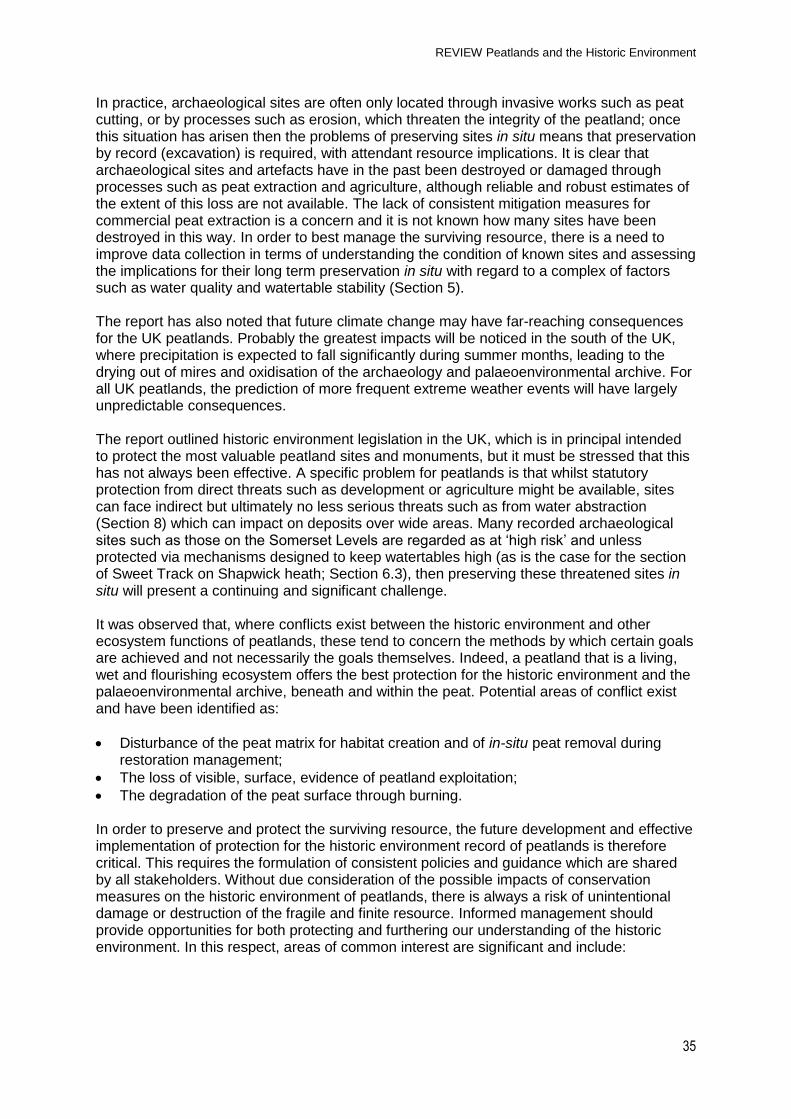
Table 6.1 Threats to UK peatlands and the historic environment record.
Exposure and destruction of archaeological sites & loss of peat as palaeoenvironmental
REVIEW Peatlands and the Historic Environment
23
resource
De-watering
Indirect
Water abstraction Drainage Reclamation – for agricultural purposes
Desiccation and degradation of peat matrix which results in destruction of archaeological & palaeoenvironmental resource
Afforestation
Direct/Indirect
Use of machinery Change in land use Alters soil chemistry Drainage Root damage
Tree planting disrupts peat stratigraphy and alters conditions for preservation of archaeological sites via increased drainage & root penetration. Loss of stratigraphic integrity of palaeo record.
Peat cutting
Direct/Indirect
Removal of resource Drainage
Destruction of archaeological and palaeoenvironmental resource. Dessication associated with drainage to permit extraction.
Burning
Direct/Indirect
Wild fires Controlled fires
Loss of peat resulting in exposure and destruction of archaeological and palaeoenvironmental resource Heat damage to stone artefacts/structures
Changes in precipitation/evaporation ratio
Direct/Indirect
Climatic change affecting peat growth & system development
Effect ability of peatlands to remain anaerobic & waterlogged and protect archaeological & palaeoenvironmental resource
Development
Direct/Indirect
Wind farms and infrastructural developments
Loss of peat related to construction and consequent exposure & destruction of archaeological and palaeoenvironmental resource
Others
Direct/Indirect Foot and vehicle traffic,
military activity
Damage leading to exposure and erosion, destruction of the archaeological and palaeoenvironmental resource
6.2 Erosion The erosion of peat can result in the direct loss of the archaeological and palaeoenvironmental resource. Work in the Peak District of England mapping the extent of peatland erosion (Phillips et al. 1981) has suggested that some 8 % of the total peat-covered landscape is now bare and that peat is being eroded locally at a rate of up to 30 mm per year. More recent attempts at quantifying upland erosion in England and Wales considered 399 upland sites (McHugh et al. 2002) and suggested that 24,566 ha were affected by erosion (0.284 km3 erosion volume), the vast majority of which (73 %) was thought to result from the action of water (e.g. see Figure 3.2). Short-term erosion measurements between
REVIEW Peatlands and the Historic Environment
24
1997 and 1999 indicated an expansion in the affected area by 518 ha. Recent fieldwork in upland peats covering most of the area of the medieval deer park at Kincardine, Scotland (Section 4) has led to the identification of two significant risks to this major peatland historic landscape (Prof. Richard Oram, University of Stirling, pers. comm.). Increased rainfall at certain times of year has accelerated erosion affecting parts of the scheduled monuments. Blockage of old water-courses and the failure of maintenance of estate drainage systems has increased motility on hillsides, leading to the erosion of large sections of the park‟s enclosing boundaries, and in some cases their complete destruction. The extent of this loss can be measured against gaps visible in aerial photographs from the 1940s.
6.3 De-watering Undrained peat can be up to 90 % water and drainage can therefore result in a significant reduction in the peat mass, whilst the related shift from anaerobic to aerobic conditions can lead to oxidation and the loss of organic matter through processes of microbial decay. Such processes are highly damaging to fragile organic archaeological remains and the associated palaeoenvironmental resource. Considerable areas of lowland peats have been lost over the last three centuries through systematic drainage and reclamation. It is estimated that 72 % of lowland peatlands in England have been converted to arable land (Van de Noort et al. 2002). This has resulted in a loss of peat through drainage, ploughing and erosion, sometimes referred to as „peat wastage‟. It is estimated that over the last half century the volume of peat lost through wastage lies between 755 and 1035 million m3 (Van de Noort et al. 2002.). Whilst the contribution from peatlands has not been quantified, 30 % of the overall supply of public freshwater for England and Wales is from groundwater abstraction (Van de Noort et al. 2002). Water abstraction in Dumfriesshire Scotland has also lowered the water table and caused water shortages (Crone & Clarke 2007). Agricultural improvement, be that via intensification or extensification, remains a significant factor. Wholesale drainage of upland peatlands, particularly in the latter half of the twentieth century, has been undertaken to facilitate expansion in pasture and upland grazing. England/UK drainage schemes implemented in the 1960s and 1970s resulted in the drainage of 1.5 million hectares of blanket peat, the residual effect of which is ongoing in the form of the slow desiccation and degradation of upland peats. Archaeological sites such as round barrows occur in upland situations throughout the UK and the partial exposure of such sites within peatland pasture is relatively commonplace. The long chambered cairn at the Cave of Kilhern in Dumfries & Galloway, Scotland and the complex of funerary and ritual structures at Beaghmore, Co. Tyrone, Northern Ireland are examples of sites exposed as a result of land „improvement‟ projects in peatlands over the last century (Pilcher 1969). The impact of reclamation and ongoing drainage of lowland peatlands for agricultural use is illustrated by the Mesolithic site of Star Carr, North Yorkshire (Mellars & Dark 1998) (Figures 6.1 & 6.2). The organic remains at this site included a brushwood „platform‟, bone and red deer antler objects. Recent work has indicated significant deterioration in the levels of preservation at the site with the archaeological and palaeoenvironmental resources highly vulnerable to the effects of drainage and agriculture (ref: www.starcarr.com accessed 03/08/10; Hall et al. 2007). Data from the Somerset Levels indicates rates of peat wastage in pasture fields at rates of 0.44 m to 0.79 m over the past century (Brunning 2002). No comparable measurements were available for peat wastage in arable fields in Somerset, but in the fenland of East Anglia assessments of wastage rates suggest a loss of 3.83 m per 100 years (Hutchinson 1980) and 2 m to 3 m per 100 years (French & Pryor 1993). Archaeological sites have often been discovered when revealed by peat wastage, such as the Bronze Age pile alignments of Harters Hill and Ivythorne (Brunning 1998) and the dug out canoe known as "Squire Phippen's big ship" which appeared during dry periods in the Brue valley until it was dismantled and used by the cottagers for fuel (Stradling 1849, 52).
These case studies illustrate the direct impact of peat wastage on the peatland archaeological and palaeoenvironmental resources. Other research illustrates the effect that deep water tables can have on the in situ preservation of the archaeological and palaeoenvironmental resource: study at the late Bronze Age site of Flag Fen, Peterborough, England has demonstrated the difficulty in preserving archaeological sites where water abstraction and other forms of development and drainage impact on the hinterland of a site and compromise the preservation of the archaeology in situ (Lillie 2007). The Neolithic Abbot's Way trackway (Cox et al. 1992) and the Iron Age settlement at Meare in the Somerset Levels (Coles et al. 1986) have both been affected by desiccation resulting from water abstraction. It has been stated that the only site that appears secure from the threat of desiccation in the Somerset Levels is the section of the Sweet Track that benefits from a pumping system which keeps water levels high in the Shapwick Heath National Nature Reserve (Brunning et al. 2000).
6.4 Afforestation Forestry is an important land use on peatland in the UK, with any peat deposit more than 0.45 m deep being classified by foresters as „deep peat‟ (Anderson 1997). Whilst new Forestry Commission policy aims to avoid peat greater than 1 m in depth, archaeological sites may still be preserved in such „shallow‟ deposits. Much afforestation has occurred on blanket bog as it was considered relatively unproductive in agricultural terms and therefore was cheap to purchase (Thompson et al. 1988). Peatlands are generally drained to facilitate tree growth with the subsequent indirect threat of dewatering to any archaeological sites. In addition, roots can directly impact deposits compromising their value for accurate palaeoenvironmental study. „Proposals for Increased woodland to take up carbon‟ is a recent government report by the National Assessment of UK Forestry and Climate Change Steering Group 2009 and 'Combating Climate Change - a role for UK forests' is becoming a policy document for future planting. The report suggests that appropriate planting of 23,000 hectares a year – over 40 years would involve changing the use of only 4 % of the UK‟s land, and is equivalent to planting the area of Lancashire every 15 years. This would mean a 200 % increase on current levels of planting with subsequent implications for the historic environment resource of peatlands.
REVIEW Peatlands and the Historic Environment
26
6.5 Peat Extraction Peat extraction has been described as representing one of the most damaging impacts on the historic environments of peatlands; it was estimated that in 1997, 0.95 million m3 of peat were extracted from peatlands in England (Van de Noort et al. 2002). Ironically, it is also the reason why peatlands have in the past yielded various archaeological discoveries (Buckland 1993). However, mechanical peat extraction provides few opportunities for the identification of archaeological sites compared to hand-cutting (Coles and Coles 1996). Moreover, since mechanical cutting requires a dry peat surface, drainage is necessary which, as described above, may have equally deleterious impacts on adjacent, un-cut deposits. The scale of commercial peat harvesting varies but mechanised large-scale peat extraction is ongoing at several sites throughout the UK & Northern Ireland. In 1999 the Peatland Working Group identified nine lowland sites in England affected by large-scale peat, including from areas designated as SSSI or identified for their nature conservation value. The associated destruction of the archaeological and palaeoenvironmental resource has not been reliably quantified but is likely to have been considerable. An assessment of impact in the Somerset Levels concluded that of 175 sites identified in this area, 59 had been partially or totally destroyed over the last 150 years, with peat extraction found to be responsible for damage to or destruction of 48 of these (Brunning 2001). In Scotland, commercial peat extraction takes place mainly, though not exclusively, in the southwest and the Central Lowlands, and on a smaller scale than in England. Crone & Clarke (2007, 22) suggest that this may be detrimental to the recognition of peat extraction in Scotland as a threat to heritage resources as: “[in] some ways the situation [vis-a-vis peat extraction] in Scotland can be characterised as the absence of a sufficiently recognisable threat to the resource.” A similar issue may apply to Northern Ireland and Wales where peat cutting also occurs on a smaller scale to England. Commercial peat extraction can be contrasted with domestic peat cutting in terms of the pace of destruction and scale of impact. Nonetheless, the latter still poses a challenge to the discovery, preservation and protection of the archaeological and palaeoenvironmental resource. In Northern Ireland, wooden trackways have been identified through peat cutting within five peatlands in Co. Tyrone (http://www.peatlandsni.gov.uk/archaeology/timber.htm accessed 03/08/10). These finds demonstrate that the lowland peats of Northern Ireland may have something close to the archaeological potential of equivalent peatlands in the Republic of Ireland.
6.6 Burning Controlled or prescribed burning is a traditional technique in the management of the vegetation of upland peatlands in particular (see Worrall et al. 2010a). For example, it has been estimated that 42 km2 of the southern Pennine moorlands was been burnt in the period from 1970-1996 (Tallis 1997). Burning at the appropriate time of year can cause minimal damage to the peat matrix itself, although its use in the future management of upland peats is currently under review (Reed et al. 2009). Extended dry periods or hot summers can lead to wild fires which, particularly during drought conditions, may become uncontrollable and cause significant damage to extensive areas. In some circumstances the peat can burn to a considerable depth and may smoulder for months. This can have significant implications for the historic environment as demonstrated on Fylingdales Moor, North Yorkshire, in the late summer of 2003 (Figure 6.3), when 2.4 km2 of moorland was devastated by a wild fire.
Figure 6.4 Example of prehistoric rock art on Fylingdales Moor exposed as a result of the fire of 2003
The Fylingdales blaze uncovered an archaeological landscape that included prehistoric field systems, rock art (Figure 6.4), funerary monuments, in addition to a network of ditches associated with the eighteenth century Stoupe Brow alum quarry, and many earthworks left over from military training during the World War II (Vyner 2007). The fire resulted in the rapid exposure of the archaeology through the loss of peat and covering mats of vegetation and roots. This left the sites vulnerable to weathering with many ephemeral features lost due to wind and water damage. It is again ironic that processes which are inimical to peatlands can help to fill in geographical gaps in our knowledge (see Section 5).
6.7 Climate change Climate change has been recognised as a potential threat to the peatland historic environment since at least the 1990s (Coles 1995; Van de Noort et al. 2002). A recent study provides estimates of the vulnerability of wetlands, including peatlands, to predicted changes in climate (Acreman et al. 2009). Current models suggest that changes in rainfall and temperature will result in reduced summer rainfall and increased summer evaporation with implications for peatlands depending on their geographical location. In this scenario North West Scotland might experience a small increase in water availability in the summer, whilst southern England would experience a decrease and associated lowering of wetland water tables (Acreman et al. 2009). Such changes are likely to place wetland plant communities, including peat-forming vegetation, under increasing stress. As a result, England may become too dry for the growth of some types of lowland mire leaving existing peatlands vulnerable to desiccation and to further degradation of the historic environment resource. Climate change may alter sea levels, weather patterns, the hydrological cycle of the peatlands and patterns of water temperatures. The effects are complex and outside the scope of this document to consider in detail but may have both benign and adverse impacts upon peatlands (see Worrall et al. 2010b).
6.8 Development Upland sites are highly desirable locations for wind farms because of their greater exposure to high winds, and peatlands predominate on the flatter summits, which are often preferred
REVIEW Peatlands and the Historic Environment
28
for engineering reasons. The extensive access tracks and turbine footprints required for such developments have the potential to lead to direct and indirect damage to the resource. Wind farms are likely to become more prevalent with the increasing appetite for generation of electricity from renewable sources.
6.9 Other threats: access and military impact Localised damage can be inflicted on peatlands by vehicles and foot traffic. This can lead to erosion and the damage and loss of peat by other agencies. Although this is a localised threat there is a direct risk to the peatlands within training grounds and ranges as a result of ordnance impact and erosion by military vehicles. For example, recent fieldwork on Blackbrook Hill, Dartmoor, identified 862 bomb craters in an area of c. 25 ha. Although no sites are currently known from this area, the base of the damaged peat has been dated to the Neolithic/early Bronze, indicating the potential for damage or destruction of any sub-peat archaeological remains (Fyfe 2008).
6.10 Summary The continued survival of the historic environment record of peatlands is faced by a range of threats. In general, any threat to the physical extent or integrity of peatlands as functioning ecosystems is also one to the archaeological and palaeoenvironmental resource. The quantification of the scale of past loss of archaeological sites is highly problematic due to the lack of reliable figures on the loss and damage to peatlands themselves, as well as a shortage of robust knowledge of the geographical distribution of the archaeological resource as discussed in Section 5. In addition, synergies between the threats listed in this section further complicate this picture. The available evidence indicates that both direct and indirect threats have impacted upon the known resource and will continue to compromise the finite and fragile archaeological and palaeoenvironmental resource of the peatlands of the UK. The following section will consider the current legislation, policies and guidance which protect the historic environment resource.
7. Protection of the peatland historic environment
Key stakeholder comment:
“At present in Scotland there is no formal policy. An objective should be to inform and educate those working in peat of what to look out for in terms of cultural heritage remains and what to do if they are encountered.”
7.1 Introduction The underlying principle for the protection and preservation of the historic environment of peatlands is in line with that for all other such heritage assets (defined as those elements of the historic environment that have significance): that the best sites should be preserved for future generations. The loss of sites removes direct evidence of our past and the chance to study it; hence the historic environment resource is regarded as finite and non-renewable. Archaeological sites and deposits preserved in-situ are considered to have the most integrity. The challenge is in determining the significance of the record and understanding how to best place value on historic places, landscapes, sites or objects (Drury & McPherson 2008).
REVIEW Peatlands and the Historic Environment
29
7.2 Legislation and guidance Statutory protection for archaeological sites across the United Kingdom is through designation, and a number of Scheduled Monuments exist in peatlands. Further protection is afforded to archaeological sites through planning law. There are approximately 20,000 Scheduled Ancient Monuments (SM) in England, accounting for a total land area of 497 km2, of which 3.7 km² lies within peatlands (less than 1%). Statutorily protected archaeology sites in peatlands are therefore significantly under represented in the schedule. Designated sites include Glastonbury lake village and part of the Neolithic Sweet Track in the Somerset Levels (see Section 4), but do not currently include two of the most famous archaeological sites in England‟s peatlands, Flag Fen and Star Carr. Currently, no areas of peatland are scheduled for the significance of their palaeoenvironmental record in isolation. Some such sites are protected as geological Sites of Special Scientific Interest (SSSI). Others are designated as RIGS (Regionally Important Geological/Geomorphological Sites) and whilst not benefiting from national statutory protection, are regarded as regionally or locally representative sites where '.... consideration of their importance becomes integral to the planning process' in the words of the Earth Science Conservation Strategy (ESCS). Conservation of geological and geomorphological sites which may include areas of peatlands of palaeoenvironmental significance is part of the responsibilities of the statutory nature conservation agencies: the Countryside Council for Wales, Natural England and Scottish Natural Heritage. A major initiative to identify and describe the most important geological sites in Britain began in 1977 in the form of The Geological Conservation Review (GCR). Fifteen peatland sites in uplands and lowlands have been listed to date, most of which are located within England (Huddart & Glasser 2002). The results of the GCR programme are being published in a series of 45 volumes, the Geological Conservation Review Series (http://www.jncc.gov.uk/page-2731). Table 7.1 shows the European Conventions which have been ratified by the United Kingdom and presents the variations in primary and planning legislation which exists across the UK and Northern Ireland. Table 7.1 Active legislation, policy and guidance in the UK
England Wales Scotland N. Ireland
European Conventions (Ratified)
Valletta - The European Convention on the protection of Archaeological Heritage 1992 Ramsar - The Convention on Wetlands 1971 (established cultural importance of wetlands)
Primary Legislation
Ancient Monuments and Archaeological Areas Act (1979) - Established statutory protection for historic sites (Scheduled Monuments) and Listed buildings
Historic Monuments and Archaeological Objects Act (1995) Established Scheduled of Monuments and Listed buildings
The National Heritage Act (1983) - Established „Commissions‟ i.e. English Heritage, CADW (Wales) and Historic Scotland
In 2007 powers transferred from Department of Environment to the Northern Ireland Environment Agency (NIEA)
Planning Policy and Guidance
Planning and Policy Statement 5 (2010) - Planning for the Historic Environment
Planning Policy Wales (2010) Chapter 6 - Conserving the Historic Environment
National Planning Policy Guideline 5 (1998) Archaeology and planning and, Scottish Planning Policy 23 (2010) – Planning and the Historic Environment
PPS 6 (1999) - Planning, Archaeology and the Built Heritage
Peat deposits with geological designation protection
Geological Conservation Review (GCR) of geological and geomorphological sites undepins designation as Sites of Special Scientific Interest (SSSI‟s) Regionally Important Geological Sites (RIGS)
Areas of Special Scientific Interest (ASSI)
The Ramsar convention is an international treaty which allows for the designation of sites to safeguard the natural environment. Although the original wording of this convention does not specifically mention archaeology, when designating a „Ramsar site‟, a country must include information regarding the „Social and Cultural Value‟ of wetlands, including peatlands. This recognises that the historic environment is a significant component in understanding and managing surviving wetlands, which must be included in any restoration or management planning. In England, Planning Policy Statement 5: Planning for the Historic Environment (PPS5) sets out the Government's planning policies on conservation of the historic environment. It was published in 2010 and replaced Planning Policy Guidance 15: Planning and the Historic Environment (PPG15) and Planning Policy Guidance 16: Archaeology and Planning (PPG16). PPS5 and its predecessors enable protection, recording and enjoyment of historic environment assets through the application and monitoring of conditions set within the planning process. Comparable policies and guidance exist for Wales, Scotland and Northern Ireland (Table 7.1).
7.3 Resources and practice The challenge in protecting and managing the historic environment record of peatlands, as for all other heritage assets, relies on sites having been identified, recorded and characterised. The lack of consistent survey data and a firm knowledge base for many peatlands is therefore a key factor in terms of policy, which primarily affects the reliability, consistency and quality of information that can be provided to stakeholders by the relevant bodies. Attempts to understand and quantify the scale of the issues facing the historic environment record of peatlands in England led to the wetland survey projects and subsequent reviews described above (see Section 3). This has in turn provided the impetus for the development of research frameworks and agendas in some areas. Nowhere in the UK has developed a full research framework for the resource, although English Heritage produced The Strategy for Wetlands (Olivier & Van de Noort 2002), and the historic environment of wetlands was a theme developed within English Heritage‟s National Heritage Protection Plan (forthcoming). National Research Frameworks have also been produced for Wales and Scotland. Table 7.2 shows the strategies, both national and sub-regional that exist across the UK. Wetland Vision (www.wetlandvision.org.uk) represents a major collaborative initiative in England, involving English Heritage, The Environment Agency, Natural England, the RSPB and The Wildlife Trusts. It provides a philosophical and technical framework that highlights the potential for wetland creation, restoration and rehabilitation and has provided resources (information and grants) to support local delivery. Table 7.2 Relevant Research Frameworks & Strategies in the UK
England Wales Scotland N. Ireland
Strategies (wetlands)
MARS MAREW (2002)
Strategy for Wetlands (2002) GIS for Wetlands
NHPP
Research Framework (2001)
Historic Environment Strategic Direction
Statement and Action Plan (2009)
Scottish Archaeological
Research Framework (ScARF)
Condition and management survey of the archaeological resource in Northern Ireland. (Gormley et al. 2009)
7.4 Enhancing protection A number of key issues, underpinned by stakeholder responses, can be identified with regards to improving the protection that could be afforded to heritage assets in future:
Variations exist in how legislation for the historic environment is interpreted and applied to peatlands;
A lack of consistency in the collection of information has led to variability in how the resource has been assessed and recorded;
There is a lack of consistency in the coverage and validity of policies and strategies for wetlands and peatlands;
Consideration of palaeoenvironmental work in peatlands should be more systematically developed in research frameworks;
Significant variations exist in terms of funding for the historic environment between regions;
Specific policies and guidance on the historic environment are not always consistently developed in those of other peatland stakeholder groups. This has long been recognised as an issue (e.g. Buckland 1993) in the development of effective protection for the archaeological and palaeoenvironmental records.
7.5 Summary Whilst historic environment legislation is available to enable the protection of the best and most valued peatland sites, it is only as effective as the knowledge which underpins selection and the ability to consistently apply such legislation. The principle of preservation in situ means that wherever possible, sites should be preserved in the ground rather than be excavated. As observed in Section 5, sites can only be protected in this way if they can be located, characterised and demonstrated to be stable within their associated burial environment; issues which can be problematic. Successful management of the archaeological and palaeoenvironmental peatland resource is therefore dependent upon the development of consistent policies and guidance, supported by a better understanding of the fragile and threatened nature of the resource. Co-operation and input from a wide range of stakeholders and partners is required to develop more effective policies. The next section outlines the areas of possible conflict and also of consensus between these different stakeholder groups.
REVIEW Peatlands and the Historic Environment
32
8. Conflicts and consensus: management priorities for the historic environment of peatlands The management priorities for the historic environment of peatlands are substantially those of other key stakeholders, although areas of possible conflict exist (Table 8.1). Generally, all groups prioritise management practices that:
Stabilise peat and reduce erosion;
Halt the physical removal of peat;
Maintain high water tables;
Promote active peat formation. These actions provide significant positive gains for the protection and preservation of the four different elements (as defined in Section 4) of the historic environment record of peatlands. In the context of peatland management, the palaeoenvironmental archive has much to offer other stakeholder groups through providing a long-term record of the extent, distribution, character and development of peatlands in the past. The palaeoenvironmental record can assist in understanding and contextualising a range of issues including hydrological and vegetation changes, management practices (including burning), carbon deposition and storage. These data also provide an evidence basis for the possible impact of future climatic change on peatland ecosystems. In this respect, the key challenge is ensuring that the practical value of palaeoenvironmental data for management and restoration is both clearly identified and effectively communicated. However, it is clear that there is still much to be achieved in terms of aligning the appropriate and proportionate application of palaeoenvironmental study to different aspects of peatland science, practice and policy. Recent initiatives such as the „Bridging the Gap‟ network should ensure continued and profitable dialogue between palaeoenvironmental researchers and other stakeholders (http://www2.hull.ac.uk/science/geography/research/environmental_change/mjb3.aspx), but it is important that both groups work more closely to identify other such models of and methods for collaboration and communication. Examples of „best practice‟ do exist, such as The Exmoor Mire Restoration Project (http://www.exmoor-nationalpark.gov.uk/mire) which has been working to restore damaged peatlands on this upland for the last 4 years (David Smith, Exmoor NPA, pers. comm.). Seventeen archaeological sites have been re-wetted and a mitigation agreement devised by the mire project office and the Exmoor NPA Archaeologists which seeks to avoid any known areas of historic interest within the peat. Plans pertaining to restoration work are submitted in advance of the work to the park‟s archaeologists to allow time for potential impact of such work on archaeologically sensitive areas, including those significant for their palaeoenvironmental record. The appropriate archaeological and/or palaeoenvironmental response can be devised including any amendments to the proposed scheme or required archaeological fieldwork. This strategy is now standard practice for any contractors or individuals undertaking hydrological restoration work on mires on Exmoor and should form the basis for future mire restoration work across the whole of the south-west of England. Where conflicts arise (Table 8.1), they tend to surround the methods by which different goals are achieved. The processes of peatland restoration undertaken in collaboration with historic environment specialists provide a means and mechanism for assessing and recording archaeological and palaeoenvironmental remains, resulting in subsequent advances in the state of knowledge. Without input from the historic environment sector, management actions that might impact directly or indirectly (Section 6) on the peat matrix pose a risk to the in situ integrity of the historic environment peatland record (Section 4). Conflicts may arise when certain conservation measures which do not require planning consent are carried out, which may preclude input from the historic environment sector and possibly lead to the discovery of
and/or unintentional damage to the archaeological and palaeoenvironmental resource. This is an issue which requires attention. Historic environment practitioners and managers, in common with carbon management groups, seek to understand peatlands on a range of scales, ranging from the „macroscale‟, such as mapping the three dimensional extent of peat deposits, through to investigating the nature and behaviour of the microenvironment of the peat matrix itself. There are clear areas of overlap in terms of future research priorities. However, methods of measuring and determining peat condition in particular can vary between stakeholders. Some groups (e.g. hydrology, biodiversity) place the emphasis on the surface, rather than the sub-surface, condition of peatlands. High water tables are a key to the preservation of the archaeological and palaeoenvironmental resource, but seasonal lowering of water tables may be desirable for nature conservation and biodiversity. Fluctuating watertables can be damaging to archaeological and palaeoenvironmental deposits. Overall, most practices are of considerable net benefit to the historic environment, provided that adequate dialogue exists with other stakeholder groups.
9. Conclusions This report has summarised the importance of peatlands for the historic environment, based principally on a review of the available literature alongside the gathering of current views from a range of stakeholders through a questionnaire survey and conference workshop. Existing literature was found to be relatively abundant for the English peatlands, with a series of large-scale wetland surveys that included the study of the largest peatlands in England undertaken since the 1970s and funded by English Heritage. Information from Northern Ireland, Scotland and Wales was less plentiful, but a number of archaeological projects that include peatlands are currently being undertaken. The main conclusions drawn in this report are summarized below. The value of peatlands for the historic landscape comprises four, in practice partially overlapping, broad categories:
1. Sub-peat archaeology, where deposits conceal the pre-peat landscape including any remains associated with human activity;
2. Archaeology within the peat matrix itself, where sites and artefacts are preserved in the peat forming environment as a result of the waterlogged, acidic and anoxic conditions that play a critical role in the long-term preservation of a range of organic – and to a lesser extent inorganic – archaeological materials;
3. Archaeology located on the surface of the peat, including the industrial archaeology and historic record of peat cutting and the surviving landscape of late medieval and early modern human activity, for example their use as Royal Forests for hunting;
4. The palaeoenvironmental archive preserved within the peat, including pollen, plant and insect remains, and other such „proxies‟ that can be studied to reveal aspects of past changes in climate, environment and vegetation. Such data are a unique resource for understanding the long term growth and development of these ecosystems.
There is variation within and between these categories. For example the majority of known archaeological sites within peat (2) tend to be located in lowland rather than upland contexts, partly as a result of the larger scale intrusive impacts such as agriculture and peat cutting on lowland peats (see section 6). It should be stressed that all peat deposits, have some value
REVIEW Peatlands and the Historic Environment
34
as palaeoenvironmental archives (4) irrespective of the presence or absence of archaeological remains. Although robust figures are not available, this report has extrapolated the known density of archaeological sites within peatlands to provide an estimate of the resource. The total number of archaeological sites beneath and within the peat, and on the peat surface is c. 22,500. The highest number of sites (c. 11,000) would be in Scotland, followed by England (c. 7,000), Northern Island (c. 3,500) and Wales (just over 300 sites). The literature review and stakeholder questionnaire identified a number of gaps in our knowledge of UK peatlands for the historic environment. These included:
A poor understanding of the spatial distribution and density of archaeological sites in peatlands;
Limits to the chronological span of sites, and a dearth of information on Roman and post-Roman peatlands where the upper layers have been removed by peat extraction or erosion;
Limits in the understanding of the factors controlling the preservation of archaeological remains within peat, in particular in relationship to hydrogeological processes;
The absence of effective (geophysical) techniques that can identify archaeological remains buried beneath or within the peat;
A lack of understanding of the impact of different management practices on the historic environment record of peatlands;
A poorly developed appreciation of the nature and value of peatlands as historic landscapes amongst the public and other stakeholders and a need to develop the role of peatlands in discussions regarding „sense of place‟.
The lack of a robust estimate of the location or number of archaeological sites in peatlands and difficulties of addressing this issue (Section 4) provides the underlying challenge for the future, as without such data, the ability to protect and manage the resource is significantly hindered. Archaeological and palaeoenvironmental surveys of peatlands in Northern Ireland, Scotland and Wales of the form undertaken in England (Section 3.2) would represent an important next step in this respect. The fragile nature of organic archaeological remains presents a different challenge to that of „dryland‟ contexts in terms of future management and protection. These main threats to peatlands as historic landscapes are essentially the same as those to the ecological functions of peatlands and include:
Destruction through peat extraction, thereby loss of archaeology and the palaeoenvironmental archive;
Erosion due to over-grazing, or foot and vehicle access, directly destroying the peatland archaeology and the palaeoenvironmental archive;
De-watering through drainage or water abstraction, thereby oxidising organic archaeology and the palaeoenvironmental archive leading to their deterioration and eventual destruction;
Reclamation for agricultural purposes, resulting in the desiccation and degradation of peat matrix and eventual destruction of archaeology and the palaeoenvironmental archive;
Afforestation which changes the soil chemistry and hydrology of the peatlands and, together with root damage, leads to damage to, and eventual destruction of, peatland archaeology and the palaeoenvironmental archive;
Burning (controlled and wild fires) leading to peat loss, resulting in exposure and destruction of archaeology and the palaeoenvironmental archive.
REVIEW Peatlands and the Historic Environment
35
In practice, archaeological sites are often only located through invasive works such as peat cutting, or by processes such as erosion, which threaten the integrity of the peatland; once this situation has arisen then the problems of preserving sites in situ means that preservation by record (excavation) is required, with attendant resource implications. It is clear that archaeological sites and artefacts have in the past been destroyed or damaged through processes such as peat extraction and agriculture, although reliable and robust estimates of the extent of this loss are not available. The lack of consistent mitigation measures for commercial peat extraction is a concern and it is not known how many sites have been destroyed in this way. In order to best manage the surviving resource, there is a need to improve data collection in terms of understanding the condition of known sites and assessing the implications for their long term preservation in situ with regard to a complex of factors such as water quality and watertable stability (Section 5). The report has also noted that future climate change may have far-reaching consequences for the UK peatlands. Probably the greatest impacts will be noticed in the south of the UK, where precipitation is expected to fall significantly during summer months, leading to the drying out of mires and oxidisation of the archaeology and palaeoenvironmental archive. For all UK peatlands, the prediction of more frequent extreme weather events will have largely unpredictable consequences. The report outlined historic environment legislation in the UK, which is in principal intended to protect the most valuable peatland sites and monuments, but it must be stressed that this has not always been effective. A specific problem for peatlands is that whilst statutory protection from direct threats such as development or agriculture might be available, sites can face indirect but ultimately no less serious threats such as from water abstraction (Section 8) which can impact on deposits over wide areas. Many recorded archaeological sites such as those on the Somerset Levels are regarded as at „high risk‟ and unless protected via mechanisms designed to keep watertables high (as is the case for the section of Sweet Track on Shapwick heath; Section 6.3), then preserving these threatened sites in situ will present a continuing and significant challenge. It was observed that, where conflicts exist between the historic environment and other ecosystem functions of peatlands, these tend to concern the methods by which certain goals are achieved and not necessarily the goals themselves. Indeed, a peatland that is a living, wet and flourishing ecosystem offers the best protection for the historic environment and the palaeoenvironmental archive, beneath and within the peat. Potential areas of conflict exist and have been identified as:
Disturbance of the peat matrix for habitat creation and of in-situ peat removal during restoration management;
The loss of visible, surface, evidence of peatland exploitation;
The degradation of the peat surface through burning. In order to preserve and protect the surviving resource, the future development and effective implementation of protection for the historic environment record of peatlands is therefore critical. This requires the formulation of consistent policies and guidance which are shared by all stakeholders. Without due consideration of the possible impacts of conservation measures on the historic environment of peatlands, there is always a risk of unintentional damage or destruction of the fragile and finite resource. Informed management should provide opportunities for both protecting and furthering our understanding of the historic environment. In this respect, areas of common interest are significant and include:
REVIEW Peatlands and the Historic Environment
36
Shared knowledge of the extent and condition of peat, and understanding peat depth and properties in 3D, which can assist management for both ecological and archaeological purposes;
An evidence basis for past changes from palaeoenvironmental research that can assist in developing peatland management practice;
The promotion of functioning, peat forming systems with high water tables serves both the conservation and associated historic environment management of peatlands equally well;
Removal of scrub and higher vegetation (plantations) returns peatlands to their natural state and helps to protect the archaeology and palaeoenvironmental archive of peatlands;
Effectively communicating the multiple benefits and unique characteristics of peatlands to local communities and the wider public.
Finally, in order to improve the quality of integrated peatland management and restoration (see Lunt et al. 2010), this report advocates increased dialogue between stakeholders involved in peatland management and conservation, focussing on five main areas:
The inclusion of appropriate archaeological and palaeoenvironmental assessments in advance of restoration/rehabilitation works. Examples of best practice exist, for example on Dartmoor, where peatland restoration works are preceded by meetings involving archaeologists and nature conservationists. Improved knowledge transfer of this form and where appropriate, training of key personnel working „on the ground‟ to recognise and record features of possible archaeological significance should be considered.
It can be highlighted that palaeoenvironmental research has the potential for informing key review areas, notably climate change; hydrological functioning and understanding trajectories of peat forming communities in the past to better inform the future. There is a pressing need to improve and maximise knowledge exchange between those carrying out such research and those involved in practice and policy.
The methodologies for defining the state and condition of peatlands need to be discussed and appropriate „fit for purpose‟ strategies developed that also seek to protect the archaeology and palaeoenvironmental archive; this could be achieved by means of monitoring additional peatland properties, such as redox potential and water quality;
Management practices that involve physical disturbance to the peat matrix need to be reviewed; this can in part be achieved by maintaining adequate records and plans of where peat has been removed from and where it has been moved to. Without appropriate guidance, certain restoration measures may lead to unintentional damage and destruction to sites and deposits, or to additional costs in terms of preserving „by record‟ sites exposed in this way. In many cases, this may be avoidable given sufficient archaeological input at the appropriate planning stage.
The broader value of the historic environment to society needs to be better communicated and exploited in the context of peatland ecosystem services. This requires those involved in the science and practice of the historic environment of peatlands to identify the key messages and to develop the language and appropriate media to transmit these most effectively to the public.
Above all, it is recommended that the historic environment needs to have a higher priority in terms of future policy options for peatland management (Reed et al. 2010). It is hoped that this report has highlighted the exceptional value of peatlands not only as unique landscapes but as knowledge archives with the potential to provide information on the past that can inform and enhance strategies for their protection and for the future benefit of society.
REVIEW Peatlands and the Historic Environment
37
Acknowledgements We are grateful to individuals and organisations who responded to the stakeholders‟ survey, particularly given the tight timescales involved. We are also grateful to Dr Jen Heathcote (English Heritage) for her invaluable advice and guidance. We are appreciative of Frank Bradford and Chris Chapman for permission to reproduce their excellent photographs. Finally, we are grateful to Dr Aletta Bonn and the other members of the IUCN Peatlands team for all of their input and support.
Stratford, C.J. (2009) A simple framework for evaluating regional wetland ecohydrological response to climate change with case studies from Great Britain. Ecohydrology, 2, 1-17.
Anderson, A. R. (1997) Forestry and Peatlands In: Conserving Peatlands. Vol. (eds, L Parkyn, R. E Stoneman and H A P Ingram) CAB International, Wallingford, Oxon, pp. 234-243.
Barber, K.E. (1981). Peat Stratigraphy and Climate Change. A.A.Balkema, Rotterdam. Barber, K.E. (1993). Peatlands as scientific archives of past biodiversity. Biodiversity and
Conservation 2, 474-489. Barber, K., Chambers, F.M., Maddy, D. & Stoneman, R. (1994) A sensitive high-resolution
record of late Holocene climatic change from a raised bog in northern England. The Holocene 4(2), 198-205.
Barber, K., Dumayne-Peaty, L., Hughes, P., Mauquoy, D. & Scaife, R. (1998) Replicability and variability of the recent macrofossil and proxy-climate record from raised bogs: field stratigraphy and macrofossil data from Bolton Fell Moss and Walton Moss, Cumbria, England. Journal of Quaternary Science 13(6), 515-528.
Berridge, P.J. (1981) Waun Fignen Felin. Archaeology in Wales, 21, 20. Brunning, R. (2002) Peat Wastage and Wetland Archaeology.
Brunning, R. (2001) A wet example: an assessment of wetland archaeology in Somerset, England. Recent developments in wetland research (WARP Occasional Paper 14). (eds B. Raftery & J. Hickey), pp. 243-250. Dept. of Archaeology, University College Dublin, Dublin.
Brunning, R., Tinsley, H. Jones, J., Jones, M. & Hogan, D. (Forthcoming). The Monuments at Risk in Somerset‟s Peatlands Project. Unpublished draft MSS. Somerset County Council.
Brunning, R. (1998) Two Bronze Age wooden structures in the Somerset Moors. Archaeology in the Severn Estuary 1997, 8, 5-8. Exeter. SELRC.
Brunning, R. (2007a) Monitoring waterlogged sites in peatlands: where, how, why and what next? Archaeology from the wetlands: recent perspectives. Proceedings of the 11th WARP Conference, Edinburgh 2005. (WARP Occasional Paper 18). (eds J. Barber, C. Clark, M. Cressey, A. Crone, A. Hale, J. Henderson, R. Housley, R. Sands & A. Sheridan), pp. 41-48. Society of Antiquaries Scotland, Edinburgh.
Brunning, R. (2007b) Monuments at risk in Somerset‟s peatlands. Archaeology from the Wetlands: recent perspectives. Proceedings of the 11th WARP Conference, Edinburgh 2005. (WARP Occasional Paper 18). (eds J. Barber, C. Clark, M. Cressey, A. Crone, A. Hale, J. Henderson, R. Housley, R. Sands & A. Sheridan), pp. 191-198. Society of Antiquaries Scotland, Edinburgh,
REVIEW Peatlands and the Historic Environment
38
Brunning, R., Hogan, D., Jones, J., Jones, M., Maltby, E., Robinson, M. & Straker, V. (2000) Saving the Sweet Track. The in situ preservation of a Neolithic wooden trackway, Somerset, UK. Conservation and management of archaeological sites, 4, 3-20.
Buckland, P. C. 1993. Peatland archaeology: a conservation resource on the edge of extinction. Biodiversity and Conservation 2, 513-517.
Cavers, G. 2006. The Scottish Wetland Archaeology Programme: Setting a Research Agenda. Scottish Wetland Archaeology Project/AOC Archaeology Group Report to Historic Scotland.
Chambers, F.M., Mauquoy, D., Gent, A., Pearson, F., Daniel, J.R.G. & Jones, P.S. (2007) Palaeoecology of degraded blanket mire in south Wales: data to inform conservation management. Biological conservation, 137 (2), 197-209.
Chapman, H.P. & Gearey, B.R. (2003) Archaeological predictive modeling in raised mires – concerns and approaches for their interpretation and management. Journal of Wetland Archaeology 2, 77-88.
Chapman, H. & Gearey, B. R. (In press) “Surprising but not always informative”: archaeological investigations of the Hatfield trackway and platform. Transactions of the Thorne and Hatfield Moors Conservation Forum.
Charman, D.J. (1994a) Geological conservation of Holocene peatlands in the National Parks of England and Wales. In: Geological and Landscape Conservation. O'Halloran, D., Green, C., Harley, M., Stanley, M. & Knill, J. (Eds.). Geological Society, London. 197-200.
Charman, D.J. (1994b) Holocene ombrotrophic peats: conservation and value in Quaternary research. In: Conserving our landscape: evolving landforms and ice-age heritage. Stevens, C., Gordon, J.E., Green, C.P. & Macklin, M.G. (Eds.). English Nature, Peterborough. 158-162.
Charman, D.J. (2002) Peatland systems and environmental change. John Wiley & Sons, Chichester.
Charman, D.J. (2010) Centennial climate variability in the British Isles during the mid-late Holocene. Quaternary Science Reviews 29, 1539-1554.
Chiverrell, R. (2001) A proxy record of late Holocene climate change from May Moss, northeast England. Journal of quaternary science, 16 (1) 9-29.
Clarke, C.& Stoneman, R. (2001) Archaeological and palaeoenvironmental investigations at North Ballachulish Moss Highland, Scotland. Recent developments in wetland research (WARP Occasional Paper 14). (eds B. Raftery & J. Hickey), pp. 201-214. Dept. of Archaeology, University College Dublin, Dublin.
Clarke, C.M., Utsi, E. Utsi, V. (1999) Ground penetrating radar investigations at North Ballachulish Moss, Highland, Scotland. Archaeological prospection 6 (2), 107 - 121
Coles, B. (1994) Wetland archaeology and wetland management. Wetland management. (eds Falconer, R.A. & Goodwin, P.), pp. 20-35. Cromwell Press, Wiltshire,
Coles, B. (1995) Wetland management, a survey for English Heritage. WARP Occasional Paper 9. University of Exeter, Exeter.
Coles, B. & Coles, J. (1986) Sweet Track to Glastonbury. The Somerset levels in prehistory. Thames & Hudson, London.
Coles, J.M. & Coles, B.J. (1996) Enlarging the Past: the contribution of wetland archaeology. Society of Antiquaries, Edinburgh and Exeter.
Coles, J.M., Rouillard, S.E. and Backway, C. (1986) The 1984 excavations at Meare. Somerset Levels Papers 12, 30-57.
Coles, J. & Coles, B. (1994-5) Enlarging the past. The contribution of wetland archaeology. (WARP Occasional Paper 10). Society of Antiquaries of Scotland & WARP.
Cox, M., Earwood, C., Jones, J., Pointing, S., Robinson., M., Straker, V. & West, S. (unpublished data) The Abbot's Way: assessment of trackway condition 1992. Unpublished MS.
Crone A. & Clarke C. (2007) Whither wetland archaeology in Scotland in the twenty-first century? Wetland archaeology & environments. Regional issues & global perspectives, (eds. M. Lillie & S. Ellis) pp. 17-29. Oxbow, Oxford.
Davies, A. (2008). Review of the historical environmental changes in the UK uplands relevant to management and policy. (http://www.sbes.stir.ac.uk/people/davies/documents/upland_history_08.pdf)
Drury, P., & McPherson, A. (2008) Conservation principles: policies and guidance for the sustainable management of the historic environment. English Heritage, London.
Ellis, C. (2001) Realising the archaeological potential of the Scottish peatlands: recent work in the Carse of Stirling, Scotland. In Enduring records: environmental and cultural heritage of wetlands (ed. B.A. Purdy), pp. 172-183. Oxford, Oxbow.
Evans, E. (2006) Prehistoric funerary and ritual monuments in Glamorgan. Archaeology in Wales, 46, 21-41.
Foley C. & MacDonagh M. (1998) Copney stone circles – a County Tyrone enigma. Archaeology Ireland, 12 (1), 24-28.
French, C.A.I. & Pryor, F.M.M., (1993) The south-west fen dyke survey project, 1982-86. East Anglian Archaeology, 59.
Fyfe, R. (2008) Archaeological and palaeoecological assessment Blackbrook Hill. Unpublished technical report for Dartmoor National Park Authority.
Fyfe, R. & Greeves, T. (2010) The date and context of a stone row: Cut Hill, Dartmoor, south-west England. Antiquity, 84, 55-70.
Gilbert, J.M. (1979) Hunting & hunting reserves in medieval Scotland. John Donald Publishers Ltd, Edinburgh.
Gormley, S., Donnelley, C., Hartwell, B. & Bell, J. (2009) Condition and management survey of the archaeological resource in Northern Ireland. CAMSAR report for the Northern Ireland Environment Agency.
Hall, A., Kenward, H., Girvan, L., McKenna, R. and King, G.A. (2007) An assessment of the palaeoecological potential of biological remains from a site at Star Carr, Vale of Pickering, North Yorkshire. Reports from the Centre for Human Palaeoecology, University of York.
Holden, J., Howard, A.J., Jared West, L., Maxfield, E., Panter, I. and Oxley, J. 2009. A critical review of hydrological data collection for assessing preservation risk for urban waterlogged archaeology: a case study from the city of York, UK. Journal of environmental management 11, 3197-3204.
Hughes, P.D.M., Lomas Clarke, S.H., Schulz, J. & Barber, K.E. (2007) Decline and localised extinction of a major raised bog species across the British Isles: evidence for associated land-use intensification. The Holocene, 18 (7), 1033-1043.
Hutchinson, J.N. 1980. The record of peat wastage in the East Anglian fenlands at Holme Post, 1848-1978 AD. Journal of ecology, 68, 229-49.
Jones, J., Tinsley, H. and Brunning, R. 2007. Methodologies for assessment of the state of preservation of pollen and plant macrofossil remains in waterlogged deposits. Environmental Archaeology 12 (1), 71-86.
Langdon, P., Hughes, P.D. & Barber, K.E. (2003) A 7500 year peat based palaeoclimatic reconstruction and evidence for an 1100 year cyclicity in bog surface wetness from Temple Hill Moss, Pentland Hills, south-east Scotland. Quaternary science reviews, 22, (2-4), 259-274.
Lawson, I., Church, M., Edwards, K.J., Cook, G.T., & Dugmore, A.J. (2007) Peat initiation in the Faroe Isles: climate change, pedogensis or human impact? Transactions of the royal society of Edinburgh earth and environmental sciences, 98, 15-28.
Lillie M. (2007) In situ preservation: geo-archaeological perspectives on an archaeological Nirvana. Wetland archaeology & environments. Regional issues & global perspectives, (eds. M. Lillie & S. Ellis), pp. 156-172. Oxbow, Oxford.
Lillie, M.C. & Smith, R. (2007) The in situ preservation of archaeological remains: using lysimeters to assess the impacts of saturation and seasonality. Journal of Archaeological Science, 34, 1494-1504.
Littlewood, N., Anderson, P., Artz, R., Bragg, O., Lunt, P. & Marrs, R. (2010) Peatland biodiversity. Report to IUCN UK Peatland Programme, Edinburgh. http://www.iucn-uk-peatlandprogramme.org/.
Lunt, P., Allott, T., Anderson, T., Buckler, M., Coupar, A., Jones, P., Labadz, J. & Worrall, P. (2010) Peatland restoration. Report to IUCN UK Peatland Programme, Edinburgh. http://www.iucn-uk-peatlandprogramme.org/Marrs, R.H., Philips, J.D.P, Todd, P.A., Ghorbani, J. and Le Duc, M.G. 2004. Control of Molinia on upland moors. Journal of Applied Ecology 41, 398-411.
Mc Cullagh, R. P. J. and Tipping, R. (1998). The Lairg Projects: The Evolution of an Archaeological Landscape in Northern Scotland. STAR Monograph.
McDermott, C. 2007 „Plain and bog, bog and wood, Wood and bog, bog and plain!‟: peatland archaeology in Ireland. Archaeology from the wetlands: recent perspectives. Proceedings of the 11th WARP Conference, Edinburgh 2005. (WARP Occasional Paper 18) (eds J. Barber, C. Clark, M. Cressey, A.Crone, A. Hale, J. Henderson, R. Housley, R. Sands & A. Sheridan). pp 17-30. Society of Antiquaries Scotland, Edinburgh.
McHugh, M., Harrod, T., & Morgan, R. (2002) The extent of soil erosion in upland England and Wales. Earth surface processes and landforms, 27(1), 99-107.
Mellars, P. & Dark, P. (eds) (1998) Star Carr in context: new archaeological and palaeoecological investigations at the early mesolithic site of Star Carr, North Yorkshire. MacDonald Institute, Cambridge.
Moore, P.D. (1993) The origin of blanket mire, revisited. Climate change and human impact of the landscape. (ed Chambers F.M.), pp. 217–224. Chapman and Hall, London.
Olivier, A. & Van de Noort, R. (2002) English Heritage strategy for wetlands. English Heritage, London.
Peat Working Group (1999) Peatland issues: Report of the working group on peat extraction and related matters. Department for Communities and Local Government. http://www.communities.gov.uk/documents/planningandbuilding/pdf/156294.pdf
Pilcher, J.R. (1969) Archaeology, palaeoecology and 14C dating of the Beaghmore stone circle site. Ulster journal of archaeology, 32, 73-91.
Phillips, J., Tallis, J.H., & Yalden, D. (1981) Peak District moorland erosion study: Phase I Report. Bakewell.
Plunkett, G. & Foley, C. (2006) Peatland archaeology in Northern Ireland: an evaluation. Journal of wetland archaeology, 6, 83-97.
Pryor, F. (2001) The Flag Fen basin: archaeology and environment of a fenland Landscape. Archaeological Reports. English Heritage, London.
Quartermaine J., Cook, J., Druce, D. & Huckerby, E. 2007. The trials and tribulations of upland peat: results of investigations into the archaeological potential of the higher peatlands. Archaeology from the wetlands: recent perspectives. Proceedings of the 11th WARP Conference, Edinburgh 2005. (WARP Occasional Paper 18) (eds J. Barber, C. Clark, M. Cressey, A.Crone, A. Hale, J. Henderson, R. Housley, R. Sands & A. Sheridan), pp. 199-212.
Ramsar Convention Secretariat 2006. The Ramsar Convention Manual: a guide to the Convention on Wetlands (Ramsar, Iran, 1971), 4th edition. Ramsar Convention Secretariat, Gland, Switzerland
Reed, M.S., Bonn, A., Slee, W., Beharry-Borg, N., Birch, J., Brown, I., Burt, T.P., Chapman, D., Chapman, P.J., Clay, G.D., Cornell, S.J., Fraser, E.D.G., Glass, J.H., Holden, J., Hodgson, J.A., Hubacek, K., Irvine, B., Jin, N., Kirkby, M.J., Kunin, W.E., Moore, O., Moseley, D., Prell, C., Price, M.F., Quinn, C.H., Redpath, S., Reid, C., Stagl, S., Stringer, L.C., Termansen, M., Thorp, S., Towers, W. & Worrall, F. (2009) The future of the uplands. Land use policy 26S, S204–S216.
Reed, M., Buckmaster, S., Moxey, A., Keenleyside, C., Fazey, I., Scott, A., Thomson, K., Thorp, S., Anderson, R., Bateman, I., Bryce, R., Christie, M., Glass, J., Hubacek, K.,
Quinn, C., Maffey, G., Midgely, A., Robinson, G., Stringer, L., Lowe, P. & Slee, B. (2010) Policy options for sustainable management of UK peatlands. Report to IUCN UK Peatland Programme, Edinburgh. http://www.iucn-uk-peatlandprogramme.org/.
Shepherd, M. and contributors (2010). Towards an assessment of the state of UK peatlands. IUCN Draft Report.
Simmons, I.G. (2003) The moorlands of England and Wales. An environmental history 8000 BC-AD 2000. Edinburgh University Press, Edinburgh.
Smith, A. G. & Cloutman, E. W. (1988) Reconstruction of Holocene vegetation history in three dimensions at Waun-Fignen-Felen, an upland site in South Wales. Philosophical transactions of the royal society of London, 322(B), 159–219.
Stradling, W. 1849. The turbaries between Glaston and the Sea. Proceedings of the Somerset archaeology and natural history society, 1 (ii), 48-62.
Tallis, J.H. (1997) Peat erosion in the Pennines: the badlands of Britain. The Macauley Land-use Research Institute, Aberdeen, UK. Biologist, 44, 277-79.
Tallis, J.H. (1998) Growth and degradation of British and Irish blanket mires. Environmental Review 6, 81–122.
Thompson, D B A, Stroud, D A and Pienkowski, M W (1988) Afforestation and Upland Birds: Consequences for Population Ecology In: Ecological Change in the Uplands. Special Publication Series of the British Ecological Society. Series No.7. Vol. (Eds, M B Usher and T D BA) Blackwell Scientific Publications, London, pp. 237-259.
Tipping, R. (2008) Blanket peat in the Scottish Highlands: timing, cause, spread and the myth of environmental determinism. Biodiversity & Conservation, 17, 2097–2113.
Tipping, R., Ashmore, P., Davies A.L., Haggart, B.A., Moir, A., Newton , A., Sands, R., Skinner, T. & Tisdall, E. (2008) Prehistoric Pinus woodland dynamics in an upland landscape in northern Scotland: the roles of climate change and human impact. Vegetation history and archaeobotany, 17, 251–267.
Turner, R.C. (1995) Britain. Bog bodies. New discoveries and new perspectives. (eds R.C. Turner & R.G. Scaife), pp. 205-221. British Museum Press, London.
Utsi, E. (2007) Wetlands viewed through the antennas of a ground penetrating radar. In SWAP (eds) Archaeology from the wetlands: recent perspectives. Proceedings of the 11th WARP Conference, Edinburgh 2005. (WARP Occasional Paper 18). (eds J. Barber, C. Clark, M. Cressey, A. Crone, A. Hale, J. Henderson, R. Housley, R. Sands & A. Sheridan), pp. 213-220. Society of Antiquaries Scotland, Edinburgh.
Van de Noort, R., (2002) Heritage management of England‟s wetlands over-arching project design. PNUM3225. English Heritage, London.
Van de Noort, R., Fletcher, W., Thomas, G., Carstairs, I., & Patrick, D. (2002) Monuments at risk in England‟s wetlands. University of Exeter report for English Heritage. www.ex.ac.uk/marew
Van de Noort, R. & O‟Sullivan, A. (2006) Rethinking Wetland Archaeology. London: Duckworth.
Van der Sanden, W. (1996). Through nature to eternity: the bog bodies of Northwest Europe. Amsterdam: Batavia.
Vyner, B. (2007) Fylingdales wildfire and archaeology. North York Moors National Park, York.
Whitehouse, N.J., Buckland, P.C., Boswijk, G. & Smith, B.M., (2001) Hatfield Moors (SE7006) The quaternary of East Yorkshire and North Lincolnshire field guide. (eds M.D. Bateman, P.C. Buckland, C.D. Frederick, & N.J. Whitehouse), pp. 179-183. Quaternary Research Association, London.
Whitehouse, N.J., Langdon, P.G., Bustin, R. & Galsworthy, S. (2008) Fossil insects and ecosystem dynamics in wetlands: implications for biodiversity and conservation. Biodiversity and conservation, 17, 2055-2078.
Worrall, F., Chapman, P., Holden, J., Evans, C., Artz, R., Smith, P. & Grayson, R. (2010a) Peatlands and climate change. Report to IUCN UK Peatland Programme, Edinburgh. http://www.iucn-uk-peatlandprogramme.org/.
Worrall, F., Clay, G.D., Marrs, R. & Reed, M.S. (2010b) Impacts of burning management on peatlands. Report to IUCN UK Peatland Programme, Edinburgh. http://www.iucn-uk-peatlandprogramme.org/.