31
Some Issues of Coastal Land Reclamation in Penang Leong Yueh Kwong 1
Some Issues of Coastal Land
Reclamation in PenangReclamation in Penang
Leong Yueh Kwong
1
Coastal land reclamation issues in Penang• 12th December 2011, Penang Local Government
Consultative forum, chaired by YB Chow Kon Yeow held forum on coastal land reclamation in Penang.
• 3 key government agencies presented their views1. Town and Country Planning Dept (JPDB) on the Policy of
land reclamation in Penang
2. 2. Penang Development Corporation on Land 2. 2. Penang Development Corporation on Land Reclamation in Penang by PDC
3. Dept of Irrigation and Drainage on its views on coastal land reclamation
• Department of Environment (DOE) gave its views on the requirements of EIA for land reclamation
• Views generally reflect what the guidelines are, but why are they not applied? More questions than answers.
2
Issues of coastal land reclamation • Present and future land reclamation. Coastal land
reclamation in Penang as strategy to increase amount of land especially on island and this will continue in the future
• Structure plan proposals for coastal land reclamation is up till 2020 and more proposals is expected in next structure plans
• DOE EIA guidelines on land reclamation not followed• DOE EIA guidelines on land reclamation not followed
• No documentation of impacts. Environmental impacts of past, present and future projects still to be documented professionally
• Legal issues of reclaimed land not resolved
• Need for integrated coastal land reclamation policy and development control in all future land reclamation proposals
3
4

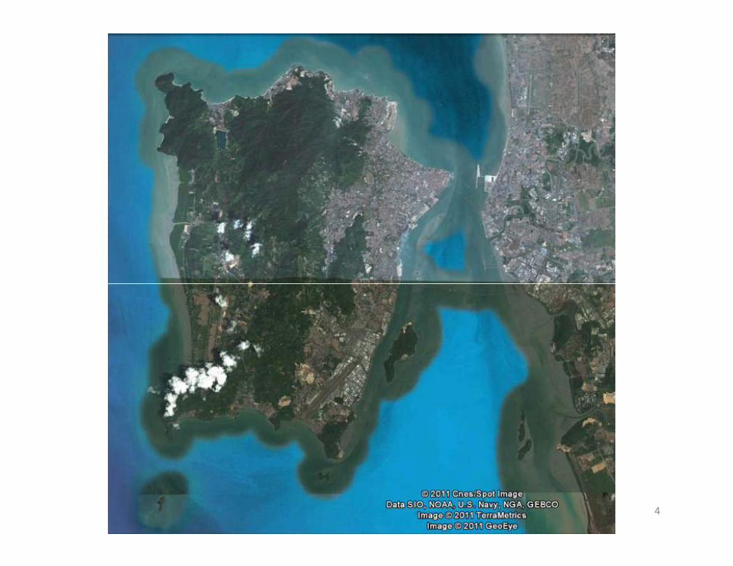
Potential for land reclamation• How much land can be reclaimed?
– Admiralty chart and bathymetry of Penang waters indicate shallow coastal waters and large potential of land reclamation at low economic cost
– One estimate in the 1970s indicated that up to 16,000 hectares may be reclaimed if based on water depthhectares may be reclaimed if based on water depth
• Potential conflicts of land reclamation
– One project may affects other parts of coastline or their functions, such as ports or hotels
– Disrupting the natural coastal processes that are in dynamic equilibrium and causes sedimentation and beach erosion in other parts
– Loss of habitats such as beaches and mangroves
– Actual amount of reclaimable land actually much lower5
6
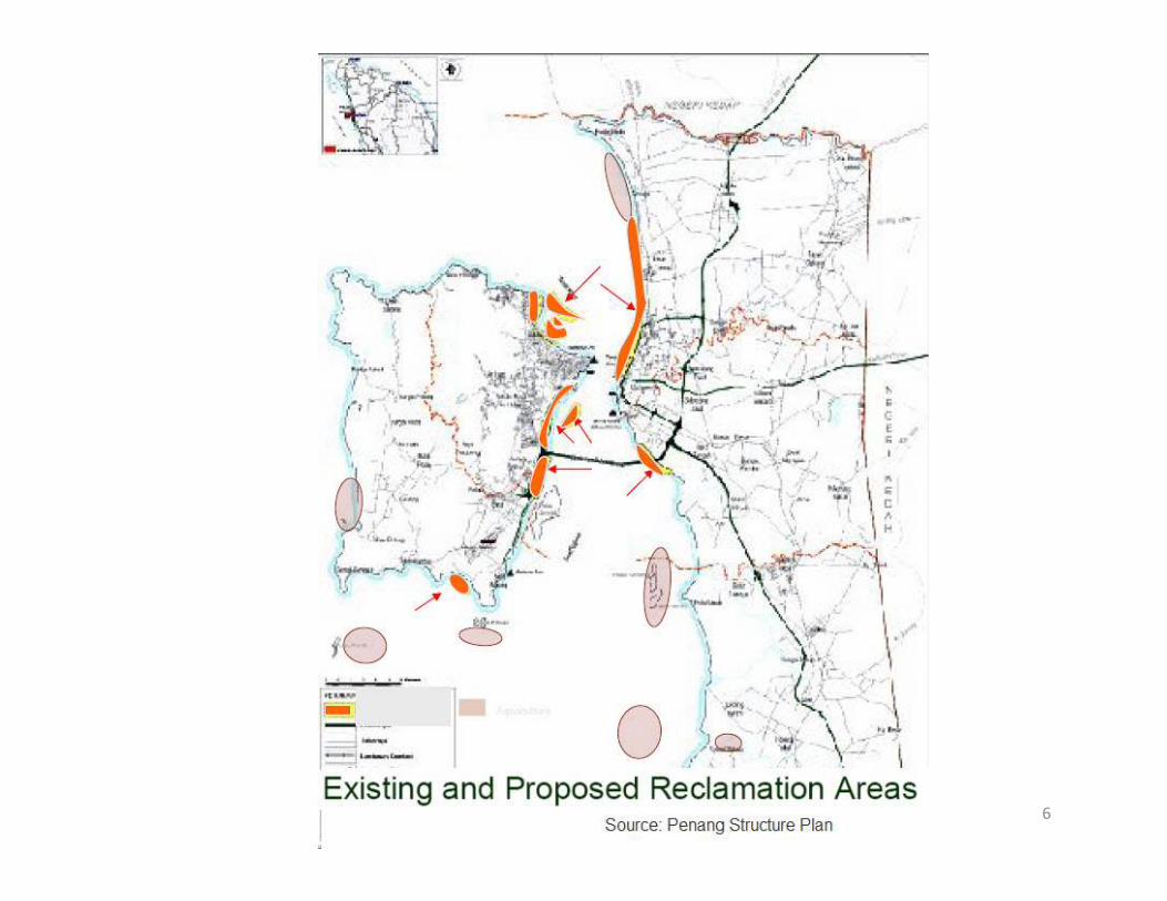
Land reclamation in the Penang
Structure Plan up to 2020
• Map of Penang and reclamation sites
• 3-4 islands in Tanjong Tokong to Gurney Drive
• Island in middle bank between Penang Island and Sebarang PeraiSebarang Perai
• South east of island around Batu Maung and Gertak Sanggul
• North of Butterworth container port
• Mud flats in Sebarang Perai south of Penang bridge
7

Past land reclamation in Penang
• Land reclamation in Koay jetty of clan jetties
for residential flats in 1970s
• Bayan Baru industrial estate in 1980s and PDC
developments in 1990sdevelopments in 1990s
• Jelutong land reclamation for coastal highway
in 1990s
• Tanjung Tokong in 2000s for residential and
commercial development
8
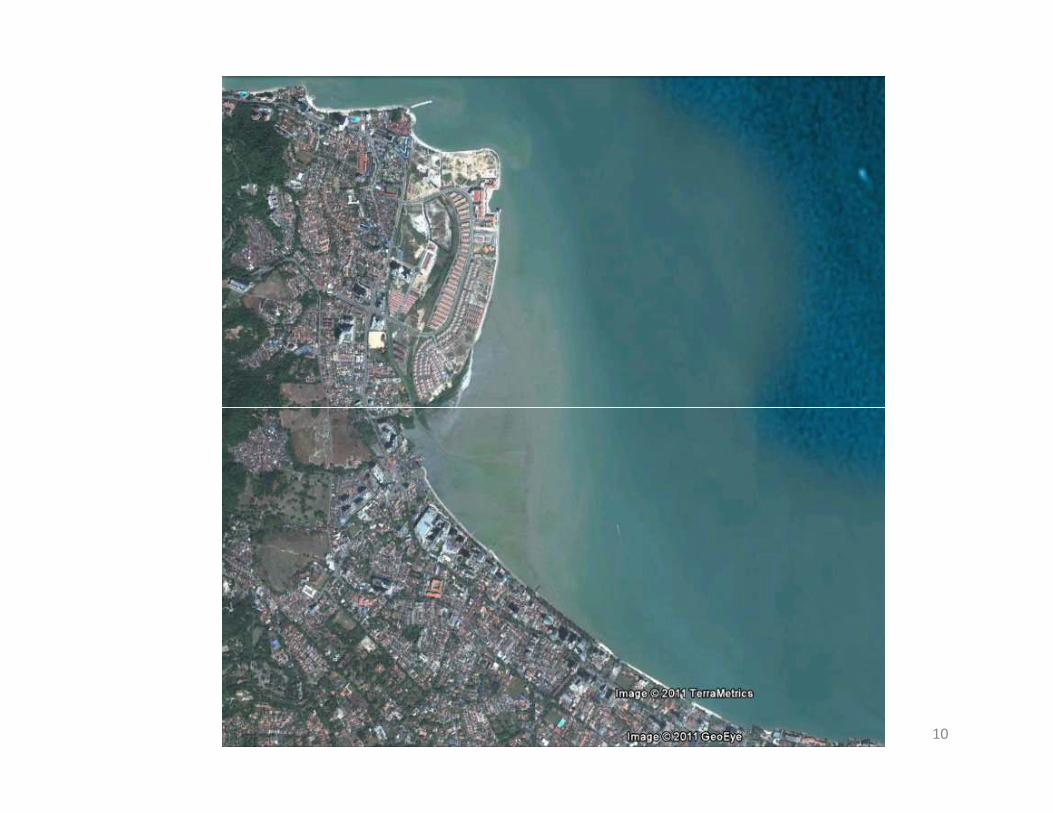
Tanjung Tokong Land Reclamation• Largest land reclamation to date for residential
and commercial purposes with 3 islands making a total of 980 acres given to private developer
• Serious siltation in Gurney Drive after phase 1 of land reclamation of 240 acres
• Only preliminary EIA submitted and approved • Only preliminary EIA submitted and approved internally by DOE in the 1980s and no monitoring of adverse impacts when land reclamation took place
• Approval in principle given for further 2 islands reclamation of 740 acres despite adverse impacts of phase 1
9
10

Land use plan11
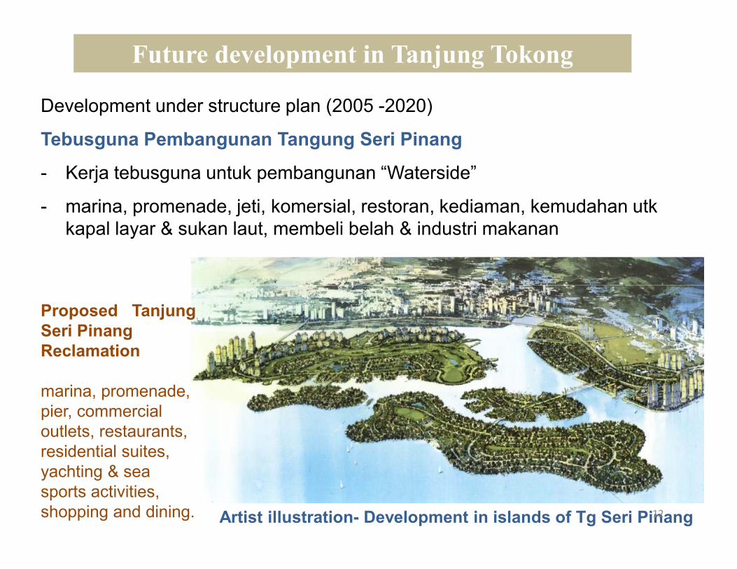
Development under structure plan (2005 -2020)
Tebusguna Pembangunan Tangung Seri Pinang
- Kerja tebusguna untuk pembangunan “Waterside”
- marina, promenade, jeti, komersial, restoran, kediaman, kemudahan utk
kapal layar & sukan laut, membeli belah & industri makanan
Future development in Tanjung Tokong
Artist illustration- Development in islands of Tg Seri Pinang
Proposed Tanjung
Seri Pinang
Reclamation
marina, promenade,
pier, commercial
outlets, restaurants,
residential suites,
yachting & sea
sports activities,
shopping and dining. 12
Land reclamation in the Straits of
Penang
• Proposed island in the middle bank in Structure Plan but this is important nursery and feeding area of commercial fish species
• Jelutong highway and IJM development
Bayan Baru reclamation for industrial • Bayan Baru reclamation for industrial development
• Queensbay land reclamation
• Batu Maung land reclamation
• Proposed land reclamation in Perai
13
Some other future projects
• Penang port proposed land reclamation of 400
hectares (about 1,000 acres) for new mini free
industrial zone and halal logistic hub in
ButterworthButterworth
• Port deepening (RM350 million)
• North of Penang bridge 61.5 hectares
• South of Penang bridge 14 ha +25 hectares of
Bayan Mutiara
14
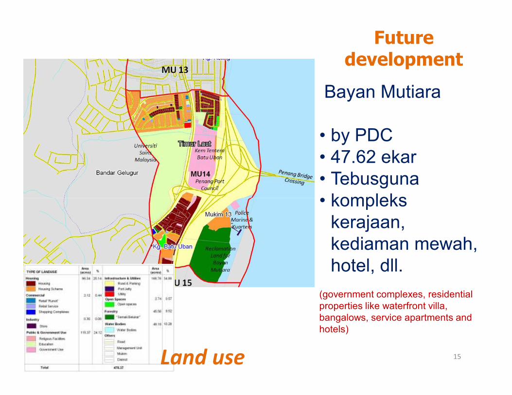
Future development
Bayan Mutiara
• by PDC
• 47.62 ekar
• Tebusguna
• kompleks • kompleks
kerajaan,
kediaman mewah,
hotel, dll.
(government complexes, residential
properties like waterfront villa,
bangalows, service apartments and
hotels)
Land use 15
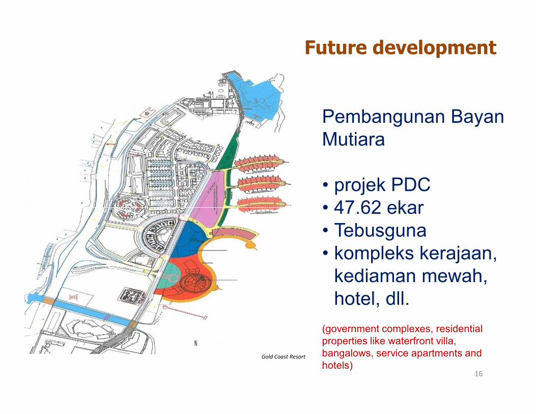
Pembangunan Bayan
Mutiara
• projek PDC
• 47.62 ekar
Future development
Gold Coast Resort
• 47.62 ekar
• Tebusguna
• kompleks kerajaan,
kediaman mewah,
hotel, dll.
(government complexes, residential
properties like waterfront villa,
bangalows, service apartments and
hotels)16
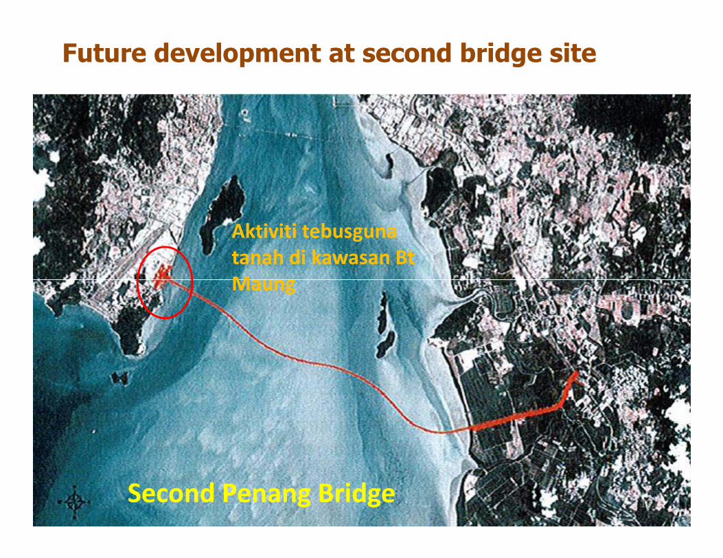
Aktiviti tebusguna
tanah di kawasan Bt
Maung
Future development at second bridge site
Maung
Second Penang Bridge17
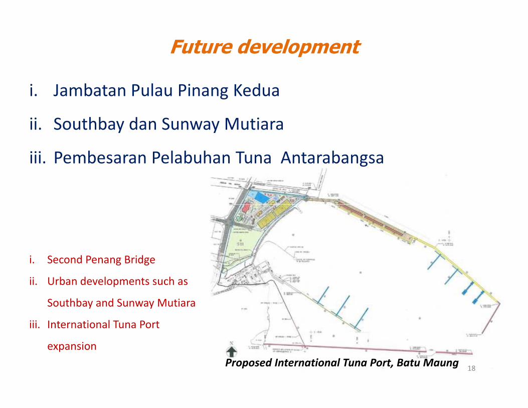
Future development
i. Jambatan Pulau Pinang Kedua
ii. Southbay dan Sunway Mutiara
iii. Pembesaran Pelabuhan Tuna Antarabangsa
Proposed International Tuna Port, Batu Maung
i. Second Penang Bridge
ii. Urban developments such as
Southbay and Sunway Mutiara
iii. International Tuna Port
expansion
18
Environmental impacts of land
reclamation• Land reclamation methods mainly from sea sand
pumped from sea bottom
• Sand preferred as fill material as mud too soft for construction and mud pushed out into sea causing pollution and sedimentation all along coastcoast
• Beach erosion takes place as dynamic equilibrium disrupted. Reclaimed area often blocks flow of currents and sediment transport
• Earth and soil not much used because of being not available and higher cost though used in some other countries. Sand also brought from other areas and neighboring states and countries
19
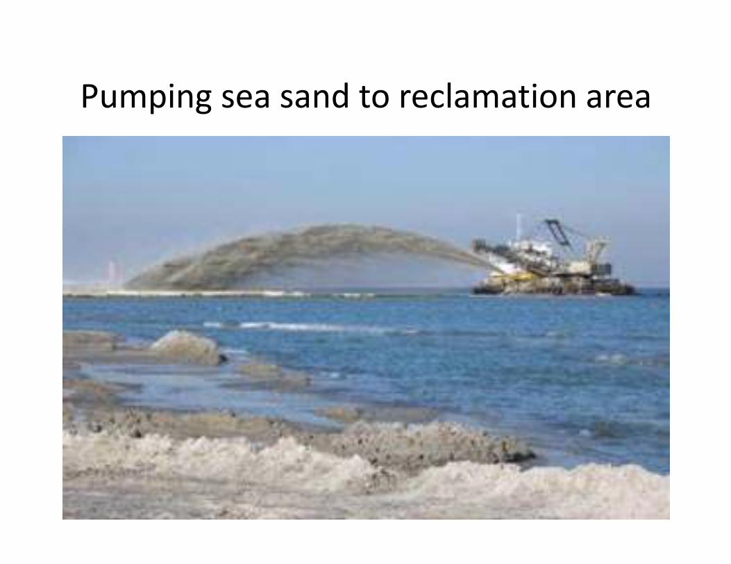
Pumping sea sand to reclamation area
20
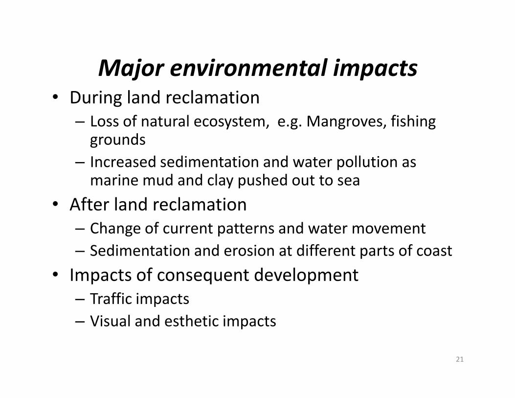
Major environmental impacts• During land reclamation
– Loss of natural ecosystem, e.g. Mangroves, fishing grounds
– Increased sedimentation and water pollution as marine mud and clay pushed out to sea
• After land reclamation• After land reclamation
– Change of current patterns and water movement
– Sedimentation and erosion at different parts of coast
• Impacts of consequent development
– Traffic impacts
– Visual and esthetic impacts
21
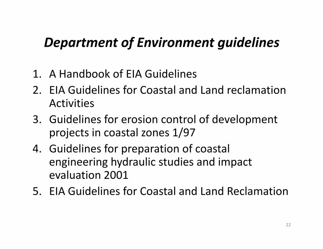
Department of Environment guidelines
1. A Handbook of EIA Guidelines
2. EIA Guidelines for Coastal and Land reclamation Activities
3. Guidelines for erosion control of development projects in coastal zones 1/97
3. Guidelines for erosion control of development projects in coastal zones 1/97
4. Guidelines for preparation of coastal engineering hydraulic studies and impact evaluation 2001
5. EIA Guidelines for Coastal and Land Reclamation
22
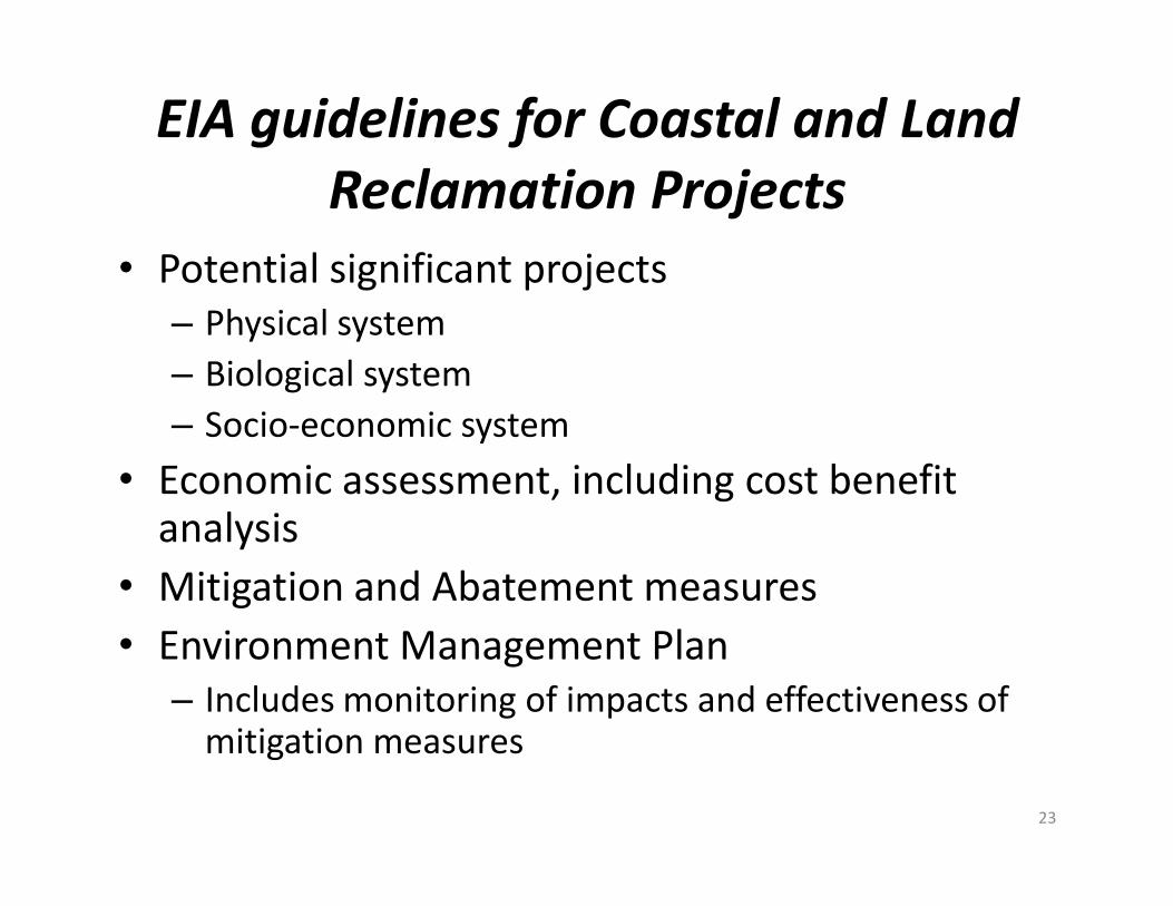
EIA guidelines for Coastal and Land
Reclamation Projects
• Potential significant projects
– Physical system
– Biological system
– Socio-economic system
• Economic assessment, including cost benefit • Economic assessment, including cost benefit analysis
• Mitigation and Abatement measures
• Environment Management Plan
– Includes monitoring of impacts and effectiveness of mitigation measures
23
Why no implementation of DOE guidelines
in major land reclamation?
• Preliminary versus detailed EIA
• No detailed EIA even for large projects like TanjungTokong
– Preliminary EIA reviewed and approval in-house in DOE often without expertise or external expert inputoften without expertise or external expert input
– Little or no public participation of affected stakeholders
• No monitoring of environmental impacts and effectiveness of proposed mitigation methods
• No accountability on part of developer to reverse adverse impacts
• No accountability of EIA consultants
24
Need to review all land reclamation projects
• Tanjung Tokong land reclamation
– Preliminary EIA done 20 years ago
– EIA predicted no adverse environmental impacts EIA proven wrong. Who is supposed to monitor impacts?
– Need a review and inquiry of what went wrong and how such a major mistake can take placehow such a major mistake can take place
– Who is responsible for siltation problems and who should pay for damage?
• DOE? EIA consultants? Developers? Government who approved the project
– Should the new state government agree in principle to the further reclamation of 2 more large islands?
– Should a new detailed EIA be required before approval of any more land reclamation? 25

Who has the right to reclaim land?
• Only State government has sole legal right to reclaim land but sometimes this right given away
• Economic benefits for public. Land in principle should not be given out to private developers as land sale as a source of income of the state. This is common practice in other countries such as Singapore and Hong Kong for government agencies to do land reclamation and then auction to get agencies to do land reclamation and then auction to get best economic deal
• Meeting social needs first before private profit. State also cannot determine land use for social needs after rights to reclaim given away to private sector. Land reclamation should be for public and social purposes which should be a higher priority than private development
• Ensure that illegal land reclamation, such as TanjungBungah “sore thumb” is stopped as this is a challenge to state authority
26
What should land reclaimed be used for?
Public open space requirements in Structure Plan
Based on 1st Penang Structure Plan of 4 ha of public open
space per 2500 persons, need in the region of 936 hectares
on Penang Island and 1000 ha in Sebarang Perai. Present
provision is 274 ha on Island and 175 in Sebarang Perai.
There is a shortfall of shortfall is 660 ha on Island and 825 in
Sebarang Perai . Total shortfall is 1486 ha.Sebarang Perai . Total shortfall is 1486 ha.
How can Penang provide public open space?
Strategy to provide recreational space that is lacking in urban
areas is through land reclamation
Public amenities
Picnic areas, recreational space, bicycle lanes, jogging tracks,
sports activities and community centers may have to come
from reclaimed land 27

Development control of reclaimed land
Development control
Land use for public open space and not development right up to water’s edge
Height control to prevent obstruction of sea view
Setback from high water markSetback from high water mark
Public access and use of coast line and beaches
Residential development and not exclusive gated communities
Commercial development including restaurants and food courts for the public and tourism
Industrial development if appropriate
28
Legal issues of reclaimed land
• Reclaimed land and the Malaysian National Land Code
– Free hold versus lease-hold land as stipulated under National Land Code, Penang policy of giving developers freehold status is illegal
• Who controls development in reclaimed land? Why MPPP and MPSP has no control over development of MPPP and MPSP has no control over development of reclaimed land? Legal loophole?
• All beaches are public from high water mark to 60 meters but developers claim all land to water front. Why is this legal requirement ignored?
• Height control guidelines in reclaimed land not applied and high rise block view and access to water front
29
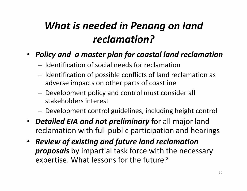
What is needed in Penang on land
reclamation?
• Policy and a master plan for coastal land reclamation
– Identification of social needs for reclamation
– Identification of possible conflicts of land reclamation as adverse impacts on other parts of coastline
– Development policy and control must consider all – Development policy and control must consider all stakeholders interest
– Development control guidelines, including height control
• Detailed EIA and not preliminary for all major land reclamation with full public participation and hearings
• Review of existing and future land reclamation
proposals by impartial task force with the necessary expertise. What lessons for the future?
30
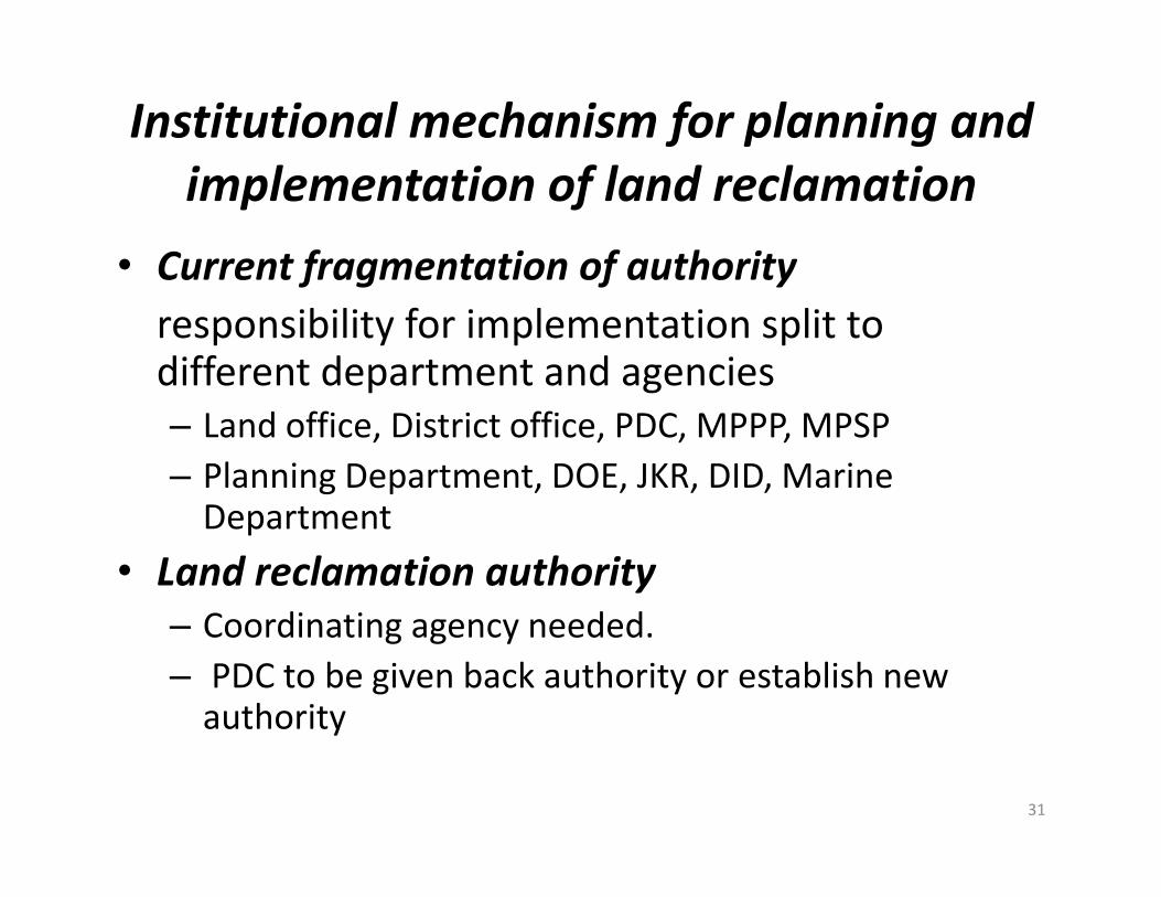
Institutional mechanism for planning and
implementation of land reclamation
• Current fragmentation of authority
responsibility for implementation split to different department and agencies
– Land office, District office, PDC, MPPP, MPSP
– Planning Department, DOE, JKR, DID, Marine Department
• Land reclamation authority
– Coordinating agency needed.
– PDC to be given back authority or establish new authority
31


