Performance of Structures in theAndaman and Nicobar Islands (India)during the December 2004 Great SumatraEarthquake and Indian OceanTsunami
C.V.R. Murty,a… M.EERI, Durgesh C. Rai,a… M.EERI, Sudhir K. Jain,a… M.EERI,
Hemant B. Kaushik,a… Goutam Mondal,a… and Suresh R. Dasha…
The damage sustained by buildings and structures in the Andaman andNicobar islands area was due to earthquake shaking and/or giant tsunamiwaves. While damage on Little Andaman Island and all the Nicobar Islandswas predominantly tsunami-related, damage on islands north of LittleAndaman Island was primarily due to earthquake shaking even though tsunamiwaves and high tides were also a concern. In general, the building stockconsists of a large number of traditional and non-engineered structures. Manytraditional structures are made of wood, and they performed well under theintensity-VII earthquake shaking sustained along the islands. However, anumber of new reinforced concrete �RC� structures suffered severe damage oreven collapse. Also, extensive damage occurred to the coastal and harborstructures in the Andaman and Nicobar islands. �DOI: 10.1193/1.2206122�
INTRODUCTION
The M=9.3 earthquake occurred on 26 December 2004 at 06:28:53 A.M. IndianStandard Time �00:58:53 UTC�. This created the most devastating tsunami in historictimes. In India, about 10,749 people died, and over 5,640 were reported missing; in all,over 2,731,900 people were affected �MHA 2005�. The extremely high death toll anddamage is attributable primarily to the deadly tsunami waves. However, extensive dam-age and loss of property in the Andaman and Nicobar �A&N� islands, India, was alsodue to the seismic shaking and was not attributable to the tsunami waves �Jain et al.2005�. The statistics from the Nicobar Islands indicated severe losses as a percentage oftotal population; by 18 January 2005, of the total Nicobar Island population of 42,068,about 1,899 were dead, 5,554 were missing, and 18,395 were in the relief camps.
The A&N islands, located southeast of mainland India, are the Indian land massesclosest to the earthquake epicenter. These islands are a narrow broken chain of about572 picturesque islands, islets, and rocks extending along a general north-south directionbetween 14° N and 6.5° N latitude stretching over a narrow arc of about 800 km in thesoutheastern part of the Bay of Bengal �Figure 1�. Of these, only about 36 islands are
a�
Department of Civil Engineering, Indian Institute of Technology Kanpur, Kanpur 208016, India
S322 C.V.R. MURTY, D. C. RAI, S. K. JAIN, H. B. KAUSHIK, G. MONDAL, AND S. R. DASH
Figure 1. The A&N islands, showing some of the larger islands of the region.
PERFORMANCE OF STRUCTURES IN THE ANDAMAN AND NICOBAR ISLANDS S323
inhabited. The islands are grouped into two sets, with the 10° N latitude internationalshipping channel standing as the divider; islands above 10° N latitude are called the An-daman Islands, and those below 10° N latitude are called the Nicobar Islands. North,Middle, South, and Little Andaman islands are the most populated among the formerislands; and Car Nicobar, Great Nicobar, Katchal, and Kamorta islands are the mostpopulated among the latter. According to the 2001 census, the total population in theA&N islands is about 356,152; about 314,084 people live in the Andaman Islands, andabout 42,068 live in the Nicobar Islands.
The 26 December 2004 earthquake occurred along the subduction plate boundarybetween the Indian plate and the Burma micro plate of the Eurasian plate. Because ofthe seismic activity in the region, the Indian seismic zone map �Figure 2� has placed theA&N islands in seismic zone V, the most severe one in the country. The location of themain shock was �200 km SSE of the nearest island �Great Nicobar Island�, about1 ,000 km SSE from Port Blair, and about 1 ,800 km SE of Chennai �formerly known asMadras�. The main shock and aftershocks suggest that the rupture extended over about1 ,300 km of the Sunda and Andaman arc �USGS 2005�. The large amount of energyreleased during this event caused high-intensity ground shaking at several locationsalong the land masses adjoining this arc. However, a preliminary estimate of the maxi-mum intensity of shaking �on the MSK scale� sustained in India is only about VII alongthe A&N islands and about V along the east coast of mainland India. The digital strong-motion instrument installed at Port Blair by the India Meteorological Department failedto record the main event. The intensity of ground shaking in Port Blair was placed atVI–VII on the MSK scale �Jain et al. 2005�. For shaking intensity VII, the average peakground acceleration is generally about 0.1 g. Analysis of a collapsed RC bicycle andmotor scooter shelter also indicates that the peak ground acceleration in Port Blair dur-ing the earthquake was about 0.1 g �Kaushik and Jain 2006�.
The distribution of tsunami-induced damage along the A&N islands followed thegeneral trend of more damage in the islands closer to the epicenter and less damage inthose farther away. Persons interviewed at Port Blair recall that the water receded beforethe first wave, and the third wave came with the greatest height and caused maximumdevastation. However, persons at locations far south of Port Blair, namely at Hut Bay,Malacca, and Campbell Bay, mention that the water level rose by about 1–2 m from thenormal sea level and remained there before the giant wave lashed the entire built envi-ronment. Eyewitnesses recall that the tallest of the giant waves was about 5 m high atCampbell Bay �in Great Nicobar Island�, about 8 m at Malacca �in Car Nicobar Island�and at Hut Bay �in Little Andaman Island�, and about 4.5 m at Port Blair �in South An-daman Island�; these wave heights were also corroborated by field measurements byvarious agencies �DST 2005� �Figure 3�. The partial shielding of the coastline at Camp-bell Bay and significant shielding of Port Blair and Campbell Bay by the steep moun-tainous outcrops from the direct tsunami waves originating from Sumatra may have con-tributed to the reduced wave heights at these locations. However, the open terrain alongthe eastern coast of the islands at Malacca and Hut Bay is seen as a reason for the largeheight of the tsunami waves.
The field investigations covered the North, Middle, South, and Little Andaman is-
S324 C.V.R. MURTY, D. C. RAI, S. K. JAIN, H. B. KAUSHIK, G. MONDAL, AND S. R. DASH
lands and the Car and Great Nicobar islands �Figure 1�. The damage sustained by build-ings and structures in the A&N area is due to both the earthquake shaking and the gianttsunami waves. It was difficult to identify the primary cause of damage in some in-stances, but input from local residents suggested the origin of damage. Hence the twotypes of damage are discussed separately, as those due to earthquake ground shakingalone and those due to the tsunami waves alone.
Figure 2. The A&N islands are in the most severe seismic zone, and the east coast of India isin the moderate-to-low seismic zone �source: BIS 2002�.
PERFORMANCE OF STRUCTURES IN THE ANDAMAN AND NICOBAR ISLANDS S325
EARTHQUAKE SHAKING-RELATED EFFECTS
GROUND DEFORMATION AND LIQUEFACTION
The shaking intensity of VI–VII in the A&N islands is low for significant liquefac-tion to be expected in these islands. However, even with low-intensity shaking, the longduration of shaking coupled with the shallow depth of the water table in many coastalareas may have contributed to occurrences of liquefaction. Evidence of liquefaction wasnoted in the South, Middle, and North Andaman islands. However, no signs of liquefac-tion were available on the ground surface in Little Andaman Island and the three Nico-bar Islands visited—namely Hut Bay, Malacca, and Campbell Bay—and even if thereonce had been such signs, the giant tsunami waves carried away large amounts of debrisand topsoil from the coastline and thus carried away evidence of any liquefaction. Also,tsunami waves deposited layers of fine soil on the land. An older mud volcano becameactive again after the shaking at Baratang in Middle Andaman Island, and several newsmall mud volcanoes also erupted, along with the occurrence of large ground deforma-tion.
Amplification of ground motion coupled with liquefaction and lateral spreading ofalluvial soil caused severe damage to the colony. Liquefaction in the form of sand boilswas observed at different places. The ground shaking was so strong that people were notable to stand during the earthquake. Lateral spreading and other liquefaction-relatedphenomena were responsible for extensive damage to residential buildings �Figure 4�and health care facilities in the low-lying areas, especially in the vicinity of water bodies,
Figure 3. Maximum tsunami wave heights at various locations in the A&N islands. The verticalbar indicates the amplitude of wave height, and the number on it indicates the value in meters.
S326 C.V.R. MURTY, D. C. RAI, S. K. JAIN, H. B. KAUSHIK, G. MONDAL, AND S. R. DASH
at several places in the northern Andaman Islands. At Mohanpur village, which sus-tained large ground amplification, thatch dwellings on wooden posts collapsed becauseof insufficient tying between the rafters and posts.
The excessive liquefaction, severe ground amplification, and occurrence of mud vol-canoes need to be understood in light of the global plate tectonics of this earthquake.Detailed investigations along with collateral evidence of plate tectonics and GPS read-ings may provide further clarity.
Figure 4. Damage to residential buildings: �a� severe damage to houses in the government resi-dential area in Nimbudera village in Middle Andaman Island, where large ground motion andliquefaction were noted; and �b� at Mohanpur village in North Andaman Island, a single-storymasonry building—despite having a light roof—sustained severe damage due to the lack of anyearthquake-resistant features; the area around the building seems to have suffered significantamplification of the ground motion �photos: G. Mondal�.
PERFORMANCE OF STRUCTURES IN THE ANDAMAN AND NICOBAR ISLANDS S327
Most of the buildings in Port Blair are constructed on sloping ground, because ofsignificant variation in the ground level on the islands. Ground sliding along the slope upto about 50–75 mm was observed at the plinth level of several buildings at AberdeenMarket and Dilanipur. The three-story RC police station building at Aberdeen Market,constructed on sloping ground, moved laterally by about 75 mm. A lateral movement ofabout 50 mm at the plinth level of a three-story RC building at Dilanipur was observedduring the visit.
Settlement of buildings was observed at several locations in Port Blair, possibly dueto foundation failure, erosion/settlement of underlying soil due to inundation of the re-gion by tsunami waves, and liquefaction. In most cases, buildings near the sea settled inthe earthquake, and signs of liquefaction, if any, were washed away when the tsunamistruck. Two RC buildings and several shops in the shopping complex in Bamboo Flatnear Port Blair settled, possibly due to liquefaction �Figure 5�. Several buildings in theharbor area in Port Blair settled due to structural failure of some of the foundation piles.Figure 6a shows settlement of piles in the passenger terminal building at Haddo Wharf.Figure 6b shows severe damage at the junction of an RC pile and its pile cap supportingan RC building used for storage at Haddo Wharf.
BUILDINGS
While damage to buildings and structures in Little Andaman Island and all the Nico-bar Islands was predominantly tsunami-related, damage in islands north of Little Anda-man Island was primarily due to earthquake shaking. In general, the building stock con-sists of a large number of traditional and non-engineered structures. Many traditional
Figure 5. Settlement of RC buildings at Bamboo Flat near Port Blair �photo: H. Kaushik�.
S328 C.V.R. MURTY, D. C. RAI, S. K. JAIN, H. B. KAUSHIK, G. MONDAL, AND S. R. DASH
structures are made of wood, and they performed well under the intensity-VII earth-quake shaking. However, a number of newly constructed RC structures suffered severedamage or even collapse due to shaking �Figure 7�.
The wood houses have a number of features that may have helped to reduce the dam-age during earthquake shaking. These features include light tin sheet roofing, masonrywalls up to only the plinth level, and a relatively simple structural configuration �Figure8a�. In some instances, the connection between the wood frame and the masonry plinth
Figure 6. �a� Foundation �RC piles� settlement/failure resulted in settlement of the passengerterminal building at Haddo Wharf. �b� Dislocation of a pile cap in an RC storage building atHaddo Wharf �photos: H. Kaushik�.
PERFORMANCE OF STRUCTURES IN THE ANDAMAN AND NICOBAR ISLANDS S329
was observed to be poorly maintained �Figure 8b�. However, even these structures per-formed well in contrast to the brittle unreinforced masonry buildings.
The A&N islands had several masonry buildings for residential and storage pur-poses, hospitals, schools, churches, jails, and so on before the severe earthquake of 26June 1941 �magnitude 7.7�. The famous masonry structure of the cellular jail was con-structed in Port Blair over a period of ten years from 1896 to 1906 using solid brickmasonry. The cellular jail was a huge structure, with a five-story central controllingtower and seven three-story wings containing 696 cells emanating from the centraltower. The masonry used in the construction of the cellular jail was of a very high qual-ity prevalent in India at that time �Figure 9�.
Several masonry structures—including a part of the cellular jail—were damagedduring the 1941 earthquake, and after independence in 1947 the Indian government de-clared the remaining three wings of the cellular jail a heritage structure. At present, onlya few masonry structures are left in Port Blair, and these performed well during theshaking.
The traditional structures built by the native islanders also demonstrate an under-standing of the effects of earthquake shaking on buildings. The huts made by theSompien tribe have a regular configuration and light mass �Figure 10�. The 2-m-diametercircular structure on eight axisymmetrically placed 75-mm-diameter posts is built at anelevation of 1.4 m. The use of local material such as bamboo and thatch makes thesestructures the first choice for housing among the native population. Unfortunately, formany reasons, more recent migrants to the islands have chosen not to adopt these ma-terials. These reasons include the prohibition against the use of wood in construction and
Figure 7. Buildings in Port Blair that were subjected to similar ground shaking intensity per-formed differently: a three-story RC-frame building collapsed in a brittle manner �photo: S.Jain�.
S330 C.V.R. MURTY, D. C. RAI, S. K. JAIN, H. B. KAUSHIK, G. MONDAL, AND S. R. DASH
Figure 8. �a� In the Port Blair area and Rangat, wooden buildings with simple configurationsperformed well during ground shaking. �b� Some buildings with poor maintenance of the join-
ery between the wood frame and masonry plinth also performed well �photos: D. Rai�.
PERFORMANCE OF STRUCTURES IN THE ANDAMAN AND NICOBAR ISLANDS S331
the migrants’ desire to have a concrete roof for protection against all weather conditions.The migrants usually choose to build masonry or RC houses directly on the ground thatare rectangular in plan.
The Army land area in Great Nicobar Island has a number of single-story barracks
Figure 9. Undamaged three-story masonry structure of the cellular jail �photo: S. Jain�.
Figure 10. Typical hut built by the Sompien tribe living in the islands. This is a prototype hut
built in the Army land area in Campbell Bay in Great Nicobar Island �photo: C. Murty�.
S332 C.V.R. MURTY, D. C. RAI, S. K. JAIN, H. B. KAUSHIK, G. MONDAL, AND S. R. DASH
built as load-bearing masonry during 1982–83 by the Border Roads Organization�BRO�. The typical barracks unit is 31.5 m long and 5.25 m wide. The ends have 3.5-m-wide rooms, but the rest of the building does not have cross walls. The superstructureis built of precast hollow cement blocks �twin cell with a 25-mm thick wall, 390 mmlong�190 mm wide�190 mm high�, while the foundation is in precast solid cementblocks. The veranda has 250-mm square plain concrete columns. The choice of plainconcrete columns was made by the BRO to reduce the use of wood; this is different fromthe usual choice of wooden columns in the traditional structures of similar configurationin the island area. The roof consists of corrugated galvanized iron �GI� sheets supportedon a steel angle truss. The bottom chord of the truss over the room is a 16-mm-diameterbar running across the room �Figure 11a�. However, there is no such truss over the ve-randa area; the rafter rests directly on these plain concrete columns without any hori-zontal ties. A continuous lintel band is provided all around, but no vertical reinforcementis provided at wall corners and openings. However, two HYSD bars of 8 mm diameterare provided at every fourth course ��800 mm centers� in the mortar bed joints. In gen-eral, these structures sustained horizontal cracks in the wall between the eave level andthe lintel band along the full length of the building. Also, the plain concrete columns inthe veranda area sustained cracks at the top and bottom. In one such building, such acolumn even collapsed �Figure 11b�. Similar buildings with a larger number of crosswalls performed better.
Often, in private masonry dwellings with load-bearing walls and a light roof trussmade of steel pipes or timber, walls were not tied together to create the necessary boxaction required for lateral resistance in masonry construction. No positive connectionwas provided between the walls and the truss members resting on them; masonry wallscollapsed out-of-plane during large movement of the flexible roof that consists of poorlyjointed wooden truss members. Similar damage was observed at a much larger scale inmost of the school buildings, wherein the long partition walls separating two classroomshave either been badly damaged or have fallen to the ground due to out-of-plane insta-bility of these slender walls �Figure 12�. In the three-story RC Mohunpura school build-ing at Port Blair, long masonry infill walls tilted out-of-plane because of poor masonryand because of inadequate and loose joints between the RC frame and masonry walls.
Private structures that did not account for seismic forces in their design suffered col-lapses. A few RC buildings near Port Blair that had been built with nominal engineeringinputs collapsed; Figure 13 shows an example. Most of the recently constructed multi-story buildings were a mimic of the nonseismic construction being practiced in main-land India, and they performed poorly �Figure 14�. Even the structures designed andbuilt by the government fared no better. For instance, the passenger terminal building atHaddo Wharf in Port Blair is a major facility built only about 5 years ago. Since the arealies in seismic zone V, the ductile detailing is mandatory as per BIS code IS:13920 �BIS1993�. Unfortunately, the design does not follow the ductility provisions. A part of thebuilding toward the sea rests on piles, while the rest is founded on filled-up soil. Thebuilding suffered irreparable damage, with some of its columns away from the seaside
PERFORMANCE OF STRUCTURES IN THE ANDAMAN AND NICOBAR ISLANDS S333
Figure 11. Military barracks in the Army land area at Campbell Bay in Great Nicobar Island:�a� typical dimensions of a unit, �b� collapse of a plain concrete corridor column �photo: S.Dash�.
S334 C.V.R. MURTY, D. C. RAI, S. K. JAIN, H. B. KAUSHIK, G. MONDAL, AND S. R. DASH
collapsing �Figure 15�. In general, under earthquake shaking, RC-frame structures suf-fered various kinds of damage ranging from frame-infill separation and hinging at theends of frame members to complete structural collapse.
Type-design RC structures are built in the A&N islands for community facilities,such as the panchayat bhavan, and for government office buildings; these type-designswere developed in-house by the Andaman Public Works Department �APWD�. Suchstructures in the region do not follow the earthquake-resistant construction practices laidout in the Indian standards. These kinds of structures were severely damaged duringshaking intensity VII manifested in the islands. For instance, the panchayat bhavanbuilding in Nabagram, North Andaman Island, sustained severe cracking to the infillsand to the brittle RC columns in the open first story �Figure 16�. This building was alsoaffected by a smaller North Andaman earthquake �at Diglipur� in 2002 �Rai and Murty2003, 2005�; only cosmetic repairs were undertaken after that earthquake. Other suchbuildings were damaged during the 2002 North Andaman earthquake, cosmetic repairswere undertaken after that, and the buildings were once again damaged in the 2004earthquake; these include the Turtle Resort building in North Andaman Island �Figure17�, and the Mahatma Gandhi Polytechnic building and post office building in Maya-bandar in Middle Andaman Island, all built by the government.
Buildings with stilts are becoming common in the islands. A number of governmentstructures are built with this configuration; in many cases, the RC column sizes are assmall as 150–230 mm. Earthquakes across the country and the world have shown thevulnerability of such systems. In some instances, such buildings may have performedsatisfactorily, apparently because of the inadvertent presence of a number of other ele-
Figure 12. Slender masonry walls became dislodged because of out-of-plane instability andpoor connection or no connection to the surrounding structural elements at the senior secondaryschool building in Adazigin, Middle Andaman Island �photo: D. Rai�.
ments that contributed to the strength and stiffness of the story with the stilts. The dam-
PERFORMANCE OF STRUCTURES IN THE ANDAMAN AND NICOBAR ISLANDS S335
age recorded in the 2004 earthquake also shows the same trend. When the frame is madeof such small columns but is infilled with masonry walls having a large number of fen-estrations, considerable damage was observed in the masonry adjoining the columns. Inthe recently completed construction of the two-story RC-frame panchayat bhavan build-ing at Urmilapur near Rangat in Middle Andaman Island, cracks developed in at least 14columns in the first story at the location of the construction joint about 2.1 m aboveground level and about 0.6 m below the second floor.
Figure 13. An RC-frame residential building that had been built on stilts near Port Blair col-lapsed because of severe seismic shaking in the Bamboo Flat area �photos: S. Jain�.
S336 C.V.R. MURTY, D. C. RAI, S. K. JAIN, H. B. KAUSHIK, G. MONDAL, AND S. R. DASH
In Little Andaman, Car Nicobar, and Great Nicobar islands, the maximum intensityof shaking observed was only about VI on the MSK scale, as evidenced by damage tobuildings on high ground or well away from the shore. For instance, the two-story gov-ernment senior secondary school building at Hut Bay in Little Andaman Island has anF-shaped plan but a simple structural system �an RC frame with infill masonry walls atregular spacing in the short direction�. This building is situated about 2 km from theshore, and shaking caused only frame-infill separation. This building also was flooded
Figure 14. �a� Collapse of an open-story RC house at Rampur, near Mayabandar �photo: D.Rai�. �b� Collapse of the RC bare frame of a three-story building under construction at Rangat,Middle Andaman Island �photo: G. Mondal�.
PERFORMANCE OF STRUCTURES IN THE ANDAMAN AND NICOBAR ISLANDS S337
up to about 1.5 m above the finished floor level but did not sustain any structural dam-age from this water level. There are also other instances of shaking-induced damage topoorly designed and/or poorly built buildings even when they were located well awayfrom the coast. For instance, the two-story telephone exchange building with a highlyirregular configuration just opposite the aforementioned school building in Hut Bay sus-tained severe damage to both the structural as well as nonstructural elements �Figure18�. The main cause is considered to be the short-column-effect damage that the venti-
Figure 15. �a� The passenger terminal building at Haddo Wharf collapsed due to the failure ofbrittle RC columns �photo: S. Jain�. �b� Failure of RC columns and large flexural cracks in RCbeams �photo: H. Kaushik�.
S338 C.V.R. MURTY, D. C. RAI, S. K. JAIN, H. B. KAUSHIK, G. MONDAL, AND S. R. DASH
lators caused to the top portion of the columns adjacent to them in the first story; thisbuilding was also flooded by about 2 m from the ground level due to the tsunami waverunup, which damaged the nonstructural elements and components in the first story. Theshort-column effect is a very common problem noticed in many structures.
In general, these structures do not follow seismic design practices, even though therequisite seismic design codes exist in India. This is exemplified by the collapse of thesingle-story bicycle and motor scooter shelter because of the earthquake ground motion.The shelter’s stiff roof resting on very slender vertical columns indicates the lack of ba-sic concepts like strong column/weak beam in the design practice �Figure 19�. An ap-proximate analysis of this collapsed RC shelter indicates that the peak ground accelera-tion in Port Blair during the earthquake was about 0.1 g �Kaushik and Jain 2006�. Also,the construction practices in such structures lack quality control, as demonstrated by theincomplete hook lengths of the lateral ties in beams even though they are closely spaced�Figure 20a� and the use of 90° hooks in the beam and column ties �Figure 20b�.
Pounding Damage
Because of the scarcity of open space, buildings in Port Blair are generally con-structed very close to each other without a sufficient gap for large lateral deformationsduring strong ground shaking. Several buildings in the Bamboo Flat shopping complex�Figure 21� suffered substantial cracking and damage at the floor level in slabs, and incolumns due to pounding with the adjacent buildings. The L-shaped three-story RCschool building at Mohanpura in Port Blair, constructed in stages between 1986 and1989, was damaged at the expansion joints in the building between different blocks.
Figure 16. The Nabagram panchayat bhavan building was shaken by two earthquakes—on 14September 2002 and 26 December 2004. Severe cracking and damage were observed in the softfirst-story columns, and columns in the first story that were primarily damaged in the 2002earthquake because of “missing” ties were now more severely damaged in the 2004 earthquake,even though they had apparently been “retrofitted” �photo: D. Rai�.
PERFORMANCE OF STRUCTURES IN THE ANDAMAN AND NICOBAR ISLANDS S339
Figure 17. A two-story RC-frame Turtle Resort building in Shibpur, south of Diglipur, with anirregular structural configuration was also damaged during the 14 September 2002 ML=6.0earthquake in North Andaman Island, but only cosmetic repairs were undertaken after thatevent. This building then sustained damage during the 26 December 2004 earthquake in thesame places. �a� Bottom of an upper-story column, and �b� top of a lower-story column �photos:
D. Rai�.
S340 C.V.R. MURTY, D. C. RAI, S. K. JAIN, H. B. KAUSHIK, G. MONDAL, AND S. R. DASH
Figure 18. The BSNL telephone exchange building on higher ground at Hut Bay in Little An-daman Island was severely damaged due to earthquake shaking—it was twisted about the ver-tical axis during the shaking and sustained severe irreparable damage in its structural members.The structure was also flooded by the tsunami runup, and severe loss was sustained in non-structural elements and contents �photo: C. Murty�.
Figure 19. Collapse of a 2-m-high shelter for bicycles and motor scooters near the Port Man-
agement Board office complex in Port Blair �photo: S. Jain�.
PERFORMANCE OF STRUCTURES IN THE ANDAMAN AND NICOBAR ISLANDS S341
Damage to Nonstructural Elements
In the old dry dock in the marine jetty dry dock complex in Port Blair, several in-stances of nonstructural damage due to earthquake shaking were observed. The falseceiling of a fiberglass boat shed collapsed completely, disrupting the already-affectedwork in the shed �Figure 22a�. Laterally unsupported masonry walls in shell structuresused as a storage area in the dry dock complex collapsed due to the absence of any con-fining elements �Figure 22b�.
Figure 20. �a� The RC-frame construction under way for the new office complex near the ma-rine jetty in Port Blair indicates poor compliance with the seismic requirements �photo: S. Jain�.�b� Use of 90° hooks in RC-frame construction in Little Andaman Island �photo: C. Murty�.
S342 C.V.R. MURTY, D. C. RAI, S. K. JAIN, H. B. KAUSHIK, G. MONDAL, AND S. R. DASH
Aircraft Hangar Structures
The steel tubular frame structure of the helicopter hangar at Car Nicobar Airport is60 m�60 m in plan, with a gable roof 14 m tall at the eave level and 21.5 m at thecrown. Eleven tubular trusses at 6-m spacing run along the transverse direction of thehangar. Each tubular truss has a 1.5 m�1.7 m rectangular plan configuration �1.7 malong the transverse direction of the hangar� with 160-mm-diameter pipes as corner el-ements, 100-mm-diameter pipes as inclined braces along the transverse direction, and80-mm pipes as horizontal braces in the longitudinal direction of the truss. The 11 tu-bular gable trusses are connected to each other through steel pipes running in the lon-gitudinal direction, except in the end bays, where three X-braces are provided over the14-m vertical height between the end two trusses �Figure 23a�. The braces are made bywelding the two pipes directly to each other without any gusset plate arrangement; thefillet welding was performed along the curved interface surface. During the earthquake,the end X-braces failed along these curved weld lines �Figure 23b�. The third-storybraces even fell down to the ground.
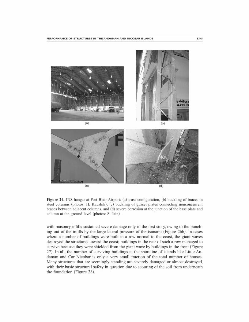
The hangar structure at Port Blair Airport, known as the INS Utkarsh Complex, alsosuffered slight damage due to ground shaking. The steel-frame structure, constructed in1986, was 50 m�50 m in plan, with a roof truss 10 m tall at the eave level and 14 m atthe crown �Figure 24a�. Many of the braces in the steel columns, which were made of15-mm square bars, were found to be buckled �Figure 24b�. Several of the gusset platesconnecting inclined brace members between adjacent columns buckled because of non-concurrent members meeting at the plate �Figure 24c�. Severe corrosion was observed atthe junction of the base plate and columns �Figure 24d�.
Figure 21. Pounding occurred between closely constructed buildings in and around Port Blair.These buildings are in the Bamboo Flat shopping complex �photo: S. Jain�.
PERFORMANCE OF STRUCTURES IN THE ANDAMAN AND NICOBAR ISLANDS S343
TSUNAMI-RELATED EFFECTS
BUILDING DAMAGE
The giant tsunami waves caused severe destruction in the coastal areas of the south-ern islands. A large number of buildings constructed right on the coast were washedaway. Complete devastation of the military residential colony south of Malacca on theeast coast of Car Nicobar Island and of the built environment on the east coast of HutBay in Little Andaman Island was observed. The non-engineered �Figure 25a� as well as
Figure 22. �a� Collapsed false ceiling of the fiberglass boat shed in the marine jetty dry dockcomplex �photo: S. Jain�. �b� Out-of-plane collapse of nonstructural masonry walls in a storagestructure at the dry dock �photo: H. Kaushik�.
S344 C.V.R. MURTY, D. C. RAI, S. K. JAIN, H. B. KAUSHIK, G. MONDAL, AND S. R. DASH
engineered RC structures performed poorly during the tsunami. However, an occasionalwell-designed RC structure can be seen standing even in the tsunami-devastated areas�Figure 25b�. In general, flat lands adjoining the coast were the hardest hit. Structuresthat thronged by the shore were subjected to positive water pressure when the giant wavearrived and suction pressure when the wave receded. This pressure loading due to thetsunami was rarely resisted by a building on the ocean front without any damage. In thebest cases, the frame of the RC-frame infilled building was intact, while the infills werepushed out of plane �Figure 26a�; presumably, the RC frames in these buildings were
Figure 23. Helicopter hangar at Car Nicobar Airport: �a� tubular truss configuration, and �b�weld failure at the X-braces in the end panels �photos: C. Murty�.
well designed and constructed. A little further from the coast, other RC-frame buildings
PERFORMANCE OF STRUCTURES IN THE ANDAMAN AND NICOBAR ISLANDS S345
with masonry infills sustained severe damage only in the first story, owing to the punch-ing out of the infills by the large lateral pressure of the tsunami �Figure 26b�. In caseswhere a number of buildings were built in a row normal to the coast, the giant wavesdestroyed the structures toward the coast; buildings in the rear of such a row managed tosurvive because they were shielded from the giant wave by buildings in the front �Figure27�. In all, the number of surviving buildings at the shoreline of islands like Little An-daman and Car Nicobar is only a very small fraction of the total number of houses.Many structures that are seemingly standing are severely damaged or almost destroyed,with their basic structural safety in question due to scouring of the soil from underneaththe foundation �Figure 28�.
Figure 24. INS hangar at Port Blair Airport: �a� truss configuration, �b� buckling of braces insteel columns �photos: H. Kaushik�, �c� buckling of gusset plates connecting nonconcurrentbraces between adjacent columns, and �d� severe corrosion at the junction of the base plate andcolumn at the ground level �photos: S. Jain�.
S346 C.V.R. MURTY, D. C. RAI, S. K. JAIN, H. B. KAUSHIK, G. MONDAL, AND S. R. DASH
Figure 25. �a� General destruction of non-engineered structures that resisted the giant tsunamiwaves in the fishermen’s colony �Machchi Dera area� at Hut Bay in Little Andaman Island�photo: C. Murty�. �b� Three-story RC-frame building with many masonry infill interior wallslocated right at the shore adjacent to the fishermen’s colony at Hut Bay in Little Andaman Is-land; this building sustained no apparent structural damage despite lateral pressure from the
tsunami �photo: S. Dash�.
PERFORMANCE OF STRUCTURES IN THE ANDAMAN AND NICOBAR ISLANDS S347
Figure 26. �a� Two-story RC-frame shorefront building with masonry infills in the military resi-dential area in Car Nicobar Island. It was inundated but resisted the wave effects. Even thoughthe building frame survived the wave effects, the great pressure sucked away the masonry in-fills, the occupants, and the contents. �b� Two-story RC-frame building with masonry infillsabout 300 m from the shore at Hut Bay in Little Andaman Island. The first story of this Anda-man & Lakshadweep Harbour Works residential facility was submerged. It sustained severestructural damage in the first story due to lateral pressure of the tsunami and could not save thelives of people in the lower story �photos: C. Murty�.
S348 C.V.R. MURTY, D. C. RAI, S. K. JAIN, H. B. KAUSHIK, G. MONDAL, AND S. R. DASH
Figure 27. Military residential area in Car Nicobar Island: �a� buildings in a row normal to theshore show progressively increasing damage toward the coast, and �b� in large shorefront struc-tures, the seaward section was severely damaged while the back side was relatively undamaged
�photos: S. Dash�.
PERFORMANCE OF STRUCTURES IN THE ANDAMAN AND NICOBAR ISLANDS S349
Of all the islands that were affected, Katchal and Kamorta islands suffered the most.But the most publicized one was Car Nicobar Island, which had the Air Force Stationand its beautiful residential colony at the seashore. The ground level at the colony is onlyslightly above sea level. The colony buildings were first shaken by the ground motion,and then, due to their proximity to the sea and low ground level, lashed by the gianttsunami waves. Many buildings were block masonry structures on strip footing; suchbuildings suffered damage due to ground shaking and liquefaction, and the final blowwas given by the tsunami waves. Most of the buildings suffered total collapse, and manyhave been washed away. The debris and household items strewn all around present a de-
Figure 28. These buildings at the Air Force Colony in Car Nicobar Island are apparently stand-ing after the tsunami, but their foundations have been scoured away �photos: C. Murty�.
S350 C.V.R. MURTY, D. C. RAI, S. K. JAIN, H. B. KAUSHIK, G. MONDAL, AND S. R. DASH
pressing view and tell the story of the brute force of the waves. The Military Engineer-ing Service �MES� inspection bungalow at the Air Force Colony on this island was situ-ated about 100 m from the seashore. Due to the eastward tilting of the Burmamicroplate on which the A&N islands are located and the subsidence of the eastern coastof the A&N islands, the shore at the Air Force Colony on Car Nicobar Island subsidedby about 1.5 m. Owing to this, the water level of the sea in this area was reported tohave risen by about 1.5 m after the earthquake. As a consequence of this ground shak-ing, subsidence, and tsunami, this building sustained severe structural damage and is ina state of incipient collapse, with the seawater lashing at its column footings �Figure 29�.
On the other hand, in the Andaman Islands, while tsunami-induced damage to thecontents of buildings was significant, the fury of the waves was less and caused lesstsunami-induced damage to the structure of the buildings themselves. For instance, inthe Bamboo Flat area near Port Blair in South Andaman Island, the street-front shopswere inundated because of land subsidence. The steel shutters of the shops were dam-aged, and the drainage covers were displaced �Figure 30�. In some other buildings in thesame region, the boundary walls collapsed. In the old dry dock in the marine jetty drydock complex in Port Blair, the water pressure caused out-of-plane collapse of the ma-sonry infill walls �Figure 31�.
HOSPITALS
Because of the tsunami, civic administrators need to consider relocating the limitedcritical infrastructure, like hospitals, at higher elevations. At Hut Bay in Little AndamanIsland, the hospital was about 500 m from the coast and sustained partial collapse duringearthquake shaking and inundation �Figure 32�. The partial collapse is attributable to the
Figure 29. This RC-frame MES inspection bungalow now stands in waters at the Air ForceColony south of Malacca on the east coast of Car Nicobar Island �photo: C. Murty�.
rusted structural steel building system that is many decades old; its main structural
PERFORMANCE OF STRUCTURES IN THE ANDAMAN AND NICOBAR ISLANDS S351
members such as columns and roof trusses are corroded, and the connections are weak-ened. The loss of the hospital severely affected the postearthquake care of the survivorson the island.
CONCLUSIONS
Severe shaking-related damage suffered by the recently constructed RC buildingsclearly shows that earthquake-resistant design and construction are not being practiced
Figure 30. �a� Inundated shops in the Bamboo Flat area near Port Blair �photo: D. Rai�, and �b�heavy RC drain covers were displaced from drains by the tsunami �photo: S. Jain�.
S352 C.V.R. MURTY, D. C. RAI, S. K. JAIN, H. B. KAUSHIK, G. MONDAL, AND S. R. DASH
in the A&N islands. In addition, the quality of material and construction was found to bequite poor in several privately owned as well as government RC buildings. The manda-tory seismic codes are not being used in designing the RC buildings, and therefore duc-tile detailing was not found in the columns of several recently constructed buildings. Onthe other hand, the traditional wood houses constructed of locally available timber per-formed extremely well in response to ground shaking. Also, several old masonry struc-tures on the islands performed well during the earthquake, thus revealing the high qual-ity of masonry construction practice prevalent in India as late as the first half of thetwentieth century. During the ground shaking, a large amount of lateral ground spread-ing, liquefaction, and landsliding occurred at several places on the islands. Repairs un-dertaken on the islands after the 2002 Diglipur earthquake in North Andaman Islandwere found to be inadequate, and such buildings sustained damage again in the 2004event.
Large-scale destruction was observed in the A&N islands after the 26 December2004 earthquake because of the tsunami. Basic issues of earthquake safety in buildings�such as integral structure with good configuration, basic stiffness, and ductility� werealso found to be helpful in resisting the tsunami effects. Coastal regulation zone require-ments need to be implemented in the region. Land-use zoning needs to be revised tomove critical facilities away from the coast.
ACKNOWLEDGMENT
The authors gratefully acknowledge the financial support from the Department ofScience and Technology, Government of India, New Delhi in conducting this reconnais-
Figure 31. The old dry dock in the marine jetty dry dock complex was inundated in seawaterafter the event, and the masonry walls were damaged �photo: H. Kaushik�.
PERFORMANCE OF STRUCTURES IN THE ANDAMAN AND NICOBAR ISLANDS S353
sance survey. Numerous individuals and organizations extended wholehearted logisticalsupport for this survey and provided relevant technical data; the authors gratefully ac-knowledge this support. In particular, the support provided by the APWD, ALHW, MES,Indian Coast Guard, Indian Air Force, and A&N Administration was critically beneficialand timely.
Figure 32. A hospital unit at Hut Bay in Little Andaman Island that is several decades old: �a�steel beds were punctured through the asbestos vertical cladding during the tsunami, and �b�collapse of the front portion of the hospital due to ground shaking �photos: C. Murty�.
S354 C.V.R. MURTY, D. C. RAI, S. K. JAIN, H. B. KAUSHIK, G. MONDAL, AND S. R. DASH
REFERENCES
Bureau of Indian Standards �BIS, 1993. Indian Standard Code of Practice for Ductile Detailingof Reinforced Concrete Structures Subjected to Seismic Forces, IS:13920-1993, BIS, NewDelhi.
Bureau of Indian Standards �BIS, 2002�. Indian Standard Criteria of Earthquake Resistant De-sign of Structures, Part I: General Provisions and Buildings, IS:1893-2002, BIS, New Delhi.
Department of Science and Technology �DST, 2005. Study of Seismic Pattern, Tidal Pattern andSubmergence to Help Locate Resettlement Areas in Andaman and Nicobar Islands, Report ofTeam of Scientific Experts, Government of India, New Delhi, March.
Jain, S. K., Murty, C.V.R., Rai, D. C., Malik, J. N., Sheth, A. R., and Jaiswal, A., 2005. Effectsof M=9 Sumatra earthquake and tsunami of 26 December 2004, Curr. Sci. 88 �3�, 357–359.
Kaushik, H. B., and Jain, S. K., 2006. Performance of buildings in Port Blair �India� during theGreat Sumatra earthquake of 26 December 2004, Paper ID 610, in Proceedings, 8th U.S.National Conference on Earthquake Engineering, 18–22 April, San Francisco, CA.
Ministry of Home Affairs �MHA, 2005�. Web site of National Disaster Management, MHA,Government of India, New Delhi, accessed 15 January 2005. www.ndmindia.nic.in
Rai, D. C., and Murty, C.V.R., 2003. North Andaman �Diglipur� Earthquake of 14 September2004, reconnaissance report, Department of Civil Engineering, Indian Institute of Technol-ogy Kanpur, April. Available at www.nicee.org
Rai, D. C., and Murty, C.V.R., 2005. Engineering lessons not learned from 2002 Diglipurearthquake—A review after 2004 Sumatra earthquake, Curr. Sci. 89 �10�, 1681–1689.
U.S. Geological Survey �USGS, 2005�. Web site, accessed on 16 November 2005. www.usgs.gov
�Received 21 February 2006; accepted 12 April 2006�