Perspectives from Digital Earth and ISPRS WG Ⅳ/9 Global Data base Towards Digital Asia Research Center Hiromichi FUKUI Faculty of Policy Management Keio University / JAXA Japan [email protected]Overview ■ ■ Geo Geo- informatics World informatics World ■ ■ From Interoperable Internet GIS From Interoperable Internet GIS to Digital Earth, Digital Asia to Digital Earth, Digital Asia ■ ■ Digital Asia Research Center Digital Asia Research Center ■ ■ Future Activities Future Activities ・ ・Digital Earth 3 Digital Earth 3- D D Geobrowsers Geobrowsers ・ ・4th International Symposium on Digital 4th International Symposium on Digital Earth Earth ・ ・Proposed Alliance framework Proposed Alliance framework
Transcript
1
Perspectives from Digital Earth and ISPRS WG Ⅳ/9 Global Data base
Towards Digital Asia Research Center
Hiromichi FUKUIFaculty of Policy ManagementKeio University / JAXA Japan
■■ GeoGeo--informatics Worldinformatics World■■ From Interoperable Internet GISFrom Interoperable Internet GIS
to Digital Earth, Digital Asiato Digital Earth, Digital Asia■■ Digital Asia Research CenterDigital Asia Research Center■■ Future ActivitiesFuture Activities
・・Digital Earth 3Digital Earth 3--D D GeobrowsersGeobrowsers・・4th International Symposium on Digital 4th International Symposium on Digital
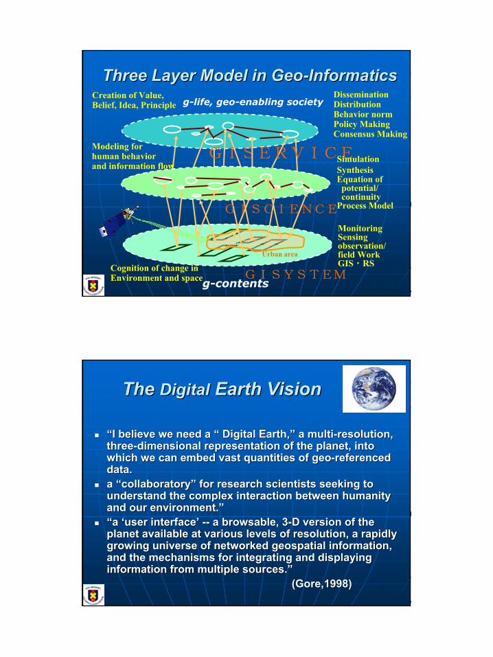
Three Layer Model in GeoThree Layer Model in Geo--InformaticsInformatics
Cognition of change inEnvironment and space
MonitoringSensingobservation/field WorkGIS・RS
GISYSTEM
Urban area
g-contents
DisseminationDistributionBehavior normPolicy MakingConsensus Making
Creation of Value, Belief, Idea, Principle
GISERVICE
g-life, geo-enabling society
SimulationSynthesisEquation of
potential/continuity
Process Model
Modeling for human behaviorand information flow
GISCIENCE
The The DigitalDigital Earth VisionEarth Vision
““I believe we need a I believe we need a ““ Digital Earth,Digital Earth,”” a multia multi--resolution, resolution, threethree--dimensional representation of the planet, into dimensional representation of the planet, into which we can embed vast quantities of geowhich we can embed vast quantities of geo--referenced referenced data.data.a a ““collaboratorycollaboratory”” for research scientists seeking to for research scientists seeking to understand the complex interaction between humanity understand the complex interaction between humanity and our environment.and our environment.””““a a ‘‘user interfaceuser interface’’ ---- a browsable, 3a browsable, 3--D version of the D version of the planet available at various levels of resolution, a rapidly planet available at various levels of resolution, a rapidly growing universe of networked geospatial information, growing universe of networked geospatial information, and the mechanisms for integrating and displaying and the mechanisms for integrating and displaying information from multiple sources.information from multiple sources.””
(Gore,1998)(Gore,1998)
3
Digital Earth (DE) Related TrendsDigital Earth (DE) Related Trends
1999 1999 --11stst Inter. Inter. SympoSympo., CAS, ., CAS, BeijingBeijing, China, , China, Towards DETowards DEEstablished Established ““International Steering Committee for ISDEInternational Steering Committee for ISDE
2001 2001 --22ndnd Inter. Inter. SympoSympo., ., New BrunswickNew Brunswick, Canada, , Canada, Beyond Inf. Infra.Beyond Inf. Infra.2003 2003 --33rdrd International Symposium, International Symposium, BrnoBrno, Czech Rep. , Czech Rep.
DE DE ---- Information Resources for Global SustainabilityInformation Resources for Global SustainabilityNew ISDE kicked off at BrnoNew ISDE kicked off at Brno
i.e. from International Symposium on DEi.e. from International Symposium on DEto International Society for DEto International Society for DE
2004 2004 --11stst International Society Board Meeting (International Society Board Meeting (tbdtbd))2005 2005 --44thth International Symposium, March 28International Symposium, March 28--31, Tokyo, Japan31, Tokyo, Japan
DE as the Global CommonsDE as the Global Commons
Implementing Components of the DE VisionImplementing Components of the DE Vision•Technology
Visualization, high-speed computing, AI, real-time computing, intelligent systems, search engines, data fusion, dynamic modeling, 3D rendering, Grid Computing, et cetera
•Standards and Interoperability ProtocolsFGDC, NSDI, GSDI, OGC, ISO, etc.
•NetworksITC, W3C. Geography.net, UNEP.net, etc.
•ContentClearinghouses, Global Databases, Global Map, etc.
•ApplicationsWeather, Land Cover, Health, Urban, Transport, et cetera
4
Framework of Digital EarthFramework of Digital Earth
NetworkProviders
IP backbone for Internet, Intranet and ExtranetNetwork securityManaged network services
Communications and collaborationInformation search and exchangeWeb applications (e.g. electronic catalogs)Content productionEDI
Need to connect to ITC mainstreamNeed to connect to ITC mainstream
tt
%%
UsersUsers
Gap Gap –– Digital DivideDigital Divide
Infrastructure and Tech. Base
Infrastructure and Tech. Base -- GSDIGSDI
Digital Earth
Digital Earth
Global Map , E
O data
Global Map , E
O data –– ContentContent
Bridging the GapBridging the Gap
Digital Asia
Digital Asia
5
Developing Spatial Data Infrastructures:
The SDI Cookbook
Version 1.115 May 2001
Editor: Douglas D. Nebert, Technical Working Group Chair, GSDI
http://www.gsdi.orgDocument available at:
Nepal 2Nepal 2
●
カトマンズ
Boundaries, VegitationsFrom ESEHorizontal-Vertical Ratio 1:10
Global Map Screenshot(Nepal)
Kathmandu
6
ISPRS WG ISPRS WG ⅣⅣ/9 Global Data base/9 Global Data baseThere are seven important points for successful global There are seven important points for successful global
environmental databases;environmental databases;longlong--term commitment and fundingterm commitment and fundingnationalnational--global and localglobal and local--global issuesglobal issues•• understanding of the effort to create global environmental DBunderstanding of the effort to create global environmental DB
as a framework database within which to place local dataas a framework database within which to place local data•• create a multicreate a multi--scalescale
useruser--producer issuesproducer issues•• meet user requirementsmeet user requirements•• resulting information by target audienceresulting information by target audience
standardization/harmonizationstandardization/harmonizationvalidation and ground truth/reference datavalidation and ground truth/reference datadata accessdata accesscultural biascultural bias
Terms of References (TBD)Compilation of existing and planned locations and the quality of global databases; Development of environmental infrastructures for access and use;Integration and harmonization environmental databases on regional, national and global levels and their promotion;Development of ontology and semantics for metadata catalogues;Development the innovative interface for browsing and analysis based of distributed environment e.g. 3D Geo-browser and Grid computing co-operation with ISCGM, WGISS, ICA, Digital Earth, IGBP, and ISPRS TC VII
ISPRS WG ISPRS WG ⅣⅣ/9 Global Data base/9 Global Data base
7
-An initiative to provide people and community with easy access to geo-spatial information over the Internet at multi-scale-by establishing a scheme to integrate and share the GIS and Remote Sensing data among all the countries of Asia,-for practical application, global change studies, sustainable development, and global environmental protection, etc.
Digital ASIA NetworkDigital ASIA Network
Cascading Benefits from Common Vision and Cascading Benefits from Common Vision and Approach for Digital Approach for Digital AsiaAsia Network and Digital EarthNetwork and Digital Earth
Education
TransportationCity Planning
NaturalResources
For all Villages:• Solve practical
problems• Contribute to
informed decision making•Communicate
with citizens
Cities Air Pollution, WaterQuality and Waste Handling
Student and Teacher Training
Biodiverstiy and Forest Management
Agriculture
Food Security andPrecision Farming
Infrastructure and Road Siting
Hurricane Landfall ForecastingFlood management
DisasterManagement
Global Connections
Governments
National Focal points
Scientists
NGOs
Citizens
Infoterra Centres
8
Development of GLOBAL LITERACY Development of GLOBAL LITERACY ee--MAP(LIT eMAP(LIT e--MAP)MAP)
1 Comprehensive GIS based information platform to 1 Comprehensive GIS based information platform to show literacy situation and progress at global, show literacy situation and progress at global, regional, and national levelsregional, and national levels
2 e2 e--MAP will consist of two databases, i.e., (1) a webMAP will consist of two databases, i.e., (1) a web--based GIS database which contain global literacy based GIS database which contain global literacy situation and leading literacy programmes and (2) situation and leading literacy programmes and (2) a a standalone GIS database which contains literacy standalone GIS database which contains literacy profile and monitor the progress at country level profile and monitor the progress at country level (Data/information to be filled in and updated on (Data/information to be filled in and updated on regular basis by countries and connected to regular basis by countries and connected to Component 1 above) Component 1 above)
9
What is MANGO?What is MANGO?
•• MMapap--base base
•• AAnalysis for nalysis for
•• NNonon--formal Education formal Education
•• GGoals and oals and
•• OOutcomes utcomes
Computer software for Computer software for community data base to community data base to support monitoring nonsupport monitoring non--formal learning activities at formal learning activities at the community level and the community level and the project level.the project level.Handbook on making and Handbook on making and using community data using community data base (with and without use base (with and without use of of MANGOMANGO software).software).UNESCO & ACCU projectUNESCO & ACCU project
ObjectivesObjectives
To develop To develop participatoryparticipatory monitoring tools for literacy and monitoring tools for literacy and continuing education projects at community and continuing education projects at community and project/district levels.project/district levels.To devise a model for using ICT to facilitate the work of To devise a model for using ICT to facilitate the work of NFE personnel.NFE personnel.To improve skills of NFE personnel on monitoring cycle To improve skills of NFE personnel on monitoring cycle (information collection, input, output, analysis, (information collection, input, output, analysis, application)application)To contribute to better documentation and advocacy of To contribute to better documentation and advocacy of NFE projects.NFE projects.
10
Digital Asia
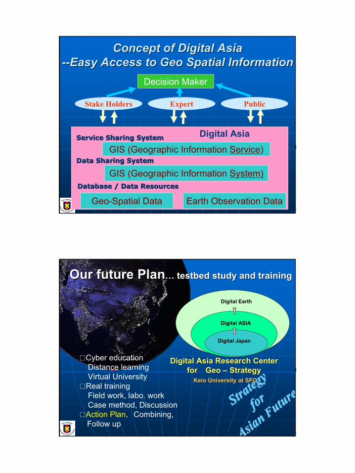
Concept of Digital Asia Concept of Digital Asia ----Easy Access to Geo Spatial InformationEasy Access to Geo Spatial Information
Earth Observation Data
GIS (Geographic Information System)
GIS (Geographic Information Service)
Geo-Spatial Data
Stake Holders PublicExpert
Database / Data Resources Database / Data Resources
Data Sharing SystemData Sharing System
Service Sharing SystemService Sharing System
Decision Maker
Strateg
y
Strateg
y
Strateg
y
forforfor
Asian
Asian
Asian FFFuture
utureuture
Digital Asia Research CenterDigital Asia Research Centerforfor Geo Geo –– StrategyStrategy
Keio University at SFCKeio University at SFC
Our future PlanOur future Plan…… testbed study and trainingtestbed study and training
Digital Japan
Digital ASIA
Digital Earth
□Cyber educationDistance learningVirtual University
Application Services・Data Retrieval and Mining ・Education ・Risk Communication etc.
Open A
pplication Interface
JAXA: Satellite Image
Local Government GeoData
Open Server
GeographyNetwork
1:25000 mapDEM
JGSI
Other Univ.Research Institute
(AIT etc)
Geobrowser
RegionalData
WMS
ObservationData
Global Map data
WMS WMS
NGOoperated Server
WMS
WMS
Interoperation
Interoperation
Meta data
Landsat-SRTM
2D Image
3D Image(View Image on the surface of sphere)
Gateway System Development for Public users Gateway System Development for Public users Data Search & View SystemData Search & View System
CategorySelection
AreaSelection
ThemeSelection
12
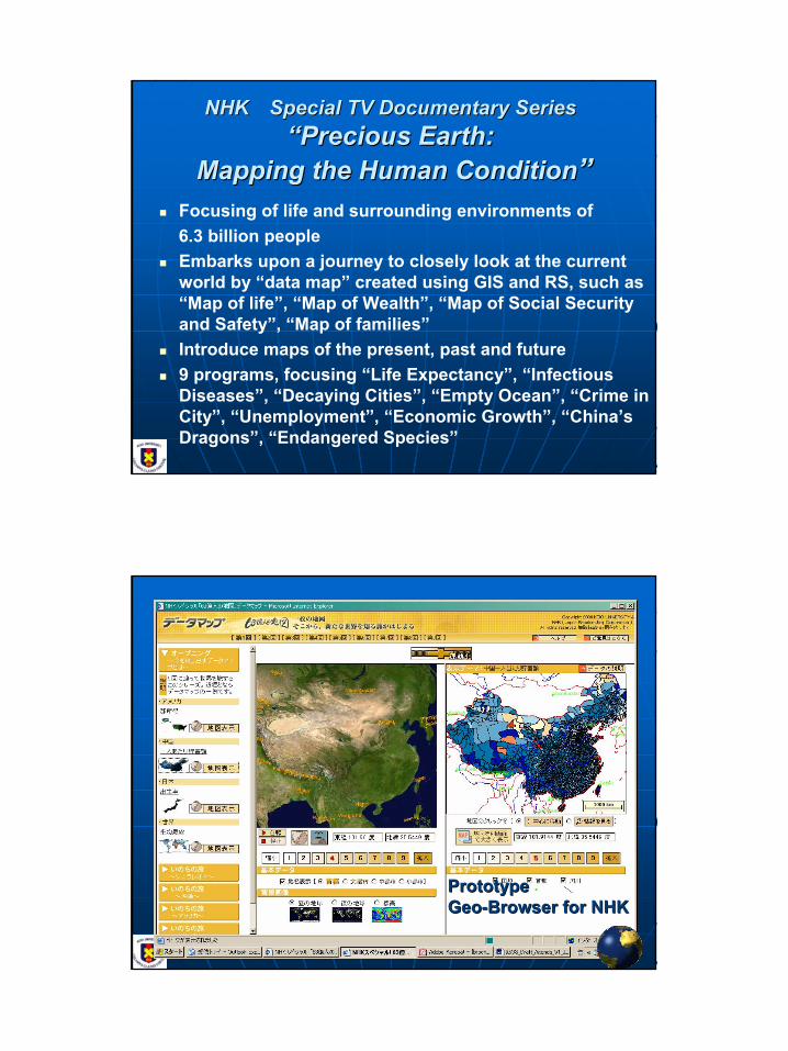
NHKNHK Special TV Documentary SeriesSpecial TV Documentary Series““Precious Earth:Precious Earth:
Mapping the Human ConditionMapping the Human Condition””Focusing of life and surrounding environments of6.3 billion peopleEmbarks upon a journey to closely look at the current world by “data map” created using GIS and RS, such as “Map of life”, “Map of Wealth”, “Map of Social Security and Safety”, “Map of families”Introduce maps of the present, past and future9 programs, focusing “Life Expectancy”, “Infectious Diseases”, “Decaying Cities”, “Empty Ocean”, “Crime in City”, “Unemployment”, “Economic Growth”, “China’s Dragons”, “Endangered Species”
PrototypePrototypeGeoGeo--Browser for NHKBrowser for NHK
13
ISDEISDE--JapanJapanISDE ISDE ––North North AmericaAmerica
UMCP/GLCFKeio/DE Lab
NASA/ GSFC/JPL
JAXA
Maryland Partners
UN/UNGIWG/UNESCO/WHO/UNEP/FAO…
WWF, CI
EarthVoice
Forest Watch
CEOS/IGOS…
HIC
Et cetera…
Keio Partners
Space Imaging
AIT Bangkok
CAS
Qinghai-Tibet
UN/UNESCO/UNU
W3C
Et cetera…
Georgia Tech
Earth Portal/EIC
DAN
GISDA
CAS
Conceptual diagram for the network and Conceptual diagram for the network and delivery of global remote sensing data via a delivery of global remote sensing data via a
JapaneseJapanese--US ISDE University AllianceUS ISDE University Alliance
Measuring the Real State of the WorldDecoding the Earth and Human EvolutionTowards IntersubjectivitiesGlobal Trends Data Resources
EO, SDISpatial Statistics
News,CommentsBlog
Grep Interface
SOAP Interface
Grid Interface
Web GIS
Media Browser
Ontological Crawler
Blog Interface
Digital Asia Community Ware
Local Contents
Google Contents
Sensing data
Participatory GIS
RSS Interface
RSS News Index
15
Digital Earth, AsiaDigital Earth, Asia…… and Pand Participatory Web GISarticipatory Web GISare a Gateway to link real world and Cyber spaceare a Gateway to link real world and Cyber spaceand to and to capture local knowledge and combining itcapture local knowledge and combining it


![NFe Library V02[1]](https://static.documents.pub/doc/80x56/5571ff8549795991699d71a5/nfe-library-v021.jpg)


