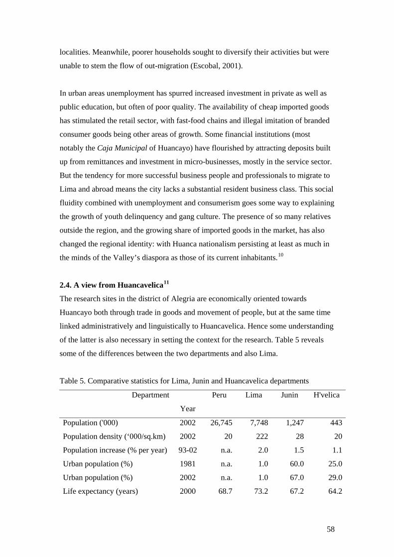
Peru Research sites: Community Profiles José Luis Álvarez, Maribel Arroyo, Lida Carhuallanqui, James Copestake, Martín Jaurapoma, Tom Lavers, Miguel Obispo, Edwin Paúcar, Percy Reina, Jorge Yamamoto. 1. Peru Context Table 1. National poverty rates for 2000 Total population Absolute poverty incidence No. (‘000) Share (%) No. (‘000) Share (%) Rate (%) National 25,625 100 13,863 100 54.1 Lima 7,400 29 3,345 24 45.2 Other coastal urban 4,552 18 2,417 17 53.1 Coastal rural 1,326 5 854 6 64.4 Highland urban 3,235 13 1,433 10 44.3 Highland rural 5,742 22 3,761 27 65.5 Jungle urban 1,548 6 797 6 51.5 Jungle rural 1,822 7 1,261 9 69.2 Source: UNDP (2002) Table 2. Peru and the human development index Year 1987 1993 1998 2004 HDI score 0.753 0.694 0.737 0.767 HDI rank 74 91 80 82 Life expectancy (year) 63 66 69 70 Adult literacy (% of population) 85 88 89 88 GDP per person rank minus HDI rank 0 -3 7 12 Source: UNDP Human Development Reports for 1990, 1996, 2000 and 2006. Peru’s first national “Human Development Report” (UNDP, 2002) provided estimates of the human development index for each department and province in the country. The latter are reproduced in Table 3, and indicate that the HDI is generally highest on the coast and lowest in the highlands, with predominantly jungle areas occupying an intermediate position. 48
Transcript
Peru Research sites: Community Profiles José Luis Álvarez, Maribel Arroyo, Lida Carhuallanqui, James Copestake, Martín
Jaurapoma, Tom Lavers, Miguel Obispo, Edwin Paúcar, Percy Reina, Jorge
pigs, chickens, dogs and cats. Wild animals in the area include pumas and foxes.
Communal working practices are very important to the farming system, and include
ayni (reciprocal help between two people), minka (everyone working together for one
person at harvest time, during the sowing season or to build a house, for example) and
faena (communal work for the benefit of the community, including cleaning ditches
and improving roads).18
Leadership of the community is divided between the teniente gobernador
(representative of the government), the justice of peace, the municipal agent and the
president of the communal association.19 There is much comparing of current with
past incumbents and competition between posts, fuelled by longstanding personal
rivalries. For example, a faena was organized to build an adobe lock-house in
response to anger at young people returning to the village from outside and not being
controlled by their families.20 But it remained unused for some time while argument
raged about who should authorize its use. Meanwhile, another faena was organized to
install new water pipes. These were provided (with much fanfare) by the municipality
but their quality subsequently became a matter of fierce argument. A much bigger
dream is to secure electricity, but most people are skeptical that the community will
ever manage to organize itself effectively enough to do so. There are no formal links
with outside political parties, indeed, most people perceive themselves to be
unaffected by outside politics and view elections as a chore because they are forced to
travel to Alegria to vote. Politicians only come to the community during municipal or
presidential elections.
The Government supports a pre-school and primary school with four teachers
and 113 pupils between them, but attendance is low. Many children do not complete
primary school, leaving to work in agriculture instead. Many marry when as young as
14 years old, and almost all by the age of twenty, by seeking permission within the
community and without servinacuy (living together first). While many dream of
securing education for their children outside their community they also complain
about being unable to finance such an investment from farming income. Meanwhile
67
the nursery and school buildings have been eroded by rain and are at risk of collapse.
People’s commitment to the school has also been undermined by disputes with one of
the teachers, suspected of stealing school materials.
Most houses have piped water, but there is neither electricity nor public
sanitation. There is a health centre in the community, but it is rarely open due to the
absence of staff and people tend to rely on traditional medicine. According to the
visiting nurse, the most frequent health problems are acute malnutrition, pneumonia,
bronchial infections, intestinal parasites and skin diseases. Additional problems
affecting women include vaginal infections, inflamed ovaries and rheumatism. The
death of a prominent member of the community (probably of AIDS) prompted
widespread anger, fear, suspicion and accusations of evildoing.
The community also has an administrative building; there is one public
telephone and four small stores that sell groceries, including liquor and coca.
Government provides food assistance through free school meals and there is one
‘glass of milk’ group.21 The government agency PRONAA also provides products like
tuna, rice, sugar, oil, yucca flour, corn and milk for children each month through the
school. Cáritas, a Catholic NGO, supports barley production and land conservation
through terracing. The Ministry of Agriculture has promoted planting of eucalyptus
and pine, and a faena was organized to establish the tree nursery, though not without
some internal dispute, because the site selected had traditional Andean spiritual
significance to the community.
Table 10. Seasonality in the Mantaro Valley: highlights
Month Seasons Crop farming Main festivals
January New Year
February
March
Wettest period.
Limited work and
money
Land cultivation and
weeding Carnival
April End of the rainy
season
Easter
May Festival of the Cross
June
Dry and sunny, but
cold at night
Main harvest period for
rain fed crops
68
July
August
Santiago
September
October Start of the rainy
season
November All Saints
December
Land preparation and
sowing
Christmas
Source: Detailed seasonal profiles for each site compiled by the field team.
4.2. Llajta Jock
Llajta Jock is located 11 kilometers along the dirt road to Llajta Iskay from Alegria. It
is also an annex of Alegria, with a similar mix of Catholic and Protestant, but the
population is smaller (212). Most people speak Spanish and Quechua, while a few
older people speak only Quechua and around 20 percent (all younger people)
speaking only Spanish. Important festivals include Santiago and Jalapato in July, for
which many migrants return home.22 Other festivals have been abandoned as there are
so few people living there. 44 houses are inhabited, all made of adobe with tiled
roofing and mostly two storey. Llajta Jock is situated on land inherited by one of four
children of the owner of a nearby hacienda. The settlement was formally recognized
as a separate annex in 1976.
As in Llajta Iskay, the main economic activities are crop and livestock
farming, and there is also an association of communal farmers. More land is in private
ownership and many people work as laborers for larger farmers, earning 8-10 Soles
per day. Some lands are irrigated and so can generate two harvests each year.
Previously the only crops were barley, wheat, beans, peas and native potatoes. But in
the last five years, richer farmers with links in Huancayo have bought land in the
community and begun to grow a wider range of potatoes, also introducing new types
of fertilizer, insecticide and fungicide. There is no access to bank credit for the
population, but loans can be obtained in emergencies from the association of
communal farmers or from neighboring families. The communal association
possesses plantations of eucalyptus which are sold when required and also owns
gypsum deposits. Cáritas technicians from Alegria offer some agricultural and
69
nutritional advice. There are three small shops, but Alegria is the main market for
selling produce.
There is a pre-school with 28 children and a primary education centre with 53
students, but they have insufficient teaching resources such as text books and other
materials. Adult illiteracy is 52 percent for women and 48 percent for men. As in
Llajta Iskay, the community does not place great emphasis on education, preferring
children to work on the farms and in the weekly market. But increasing numbers of
children do continue their education, by attending the secondary school in Alegria.
This is linked to a higher incidence of migration, destinations including Huancayo,
Lima and the central jungle where people go to assist with coffee harvesting
(especially between January and March). Many families receive groceries, clothes and
money from relatives who have moved to Lima. There is a health centre in the
community, staffed by two health technicians who work in coordination with the
health centre in Alegria. 70 percent of the population use the health post, with the
remainder relying on traditional medicine. Common ailments are similar to those in
Llajta Iskay. The community has had an electricity supply since 2003, and a bus
service runs to and from Alegria twice a week.
To become a member of the community, one must be 18 years old and
resident in the hamlet for at least one year. The community has an elected council,
governor and municipal agent, and an irrigation committee which manages water
resources jointly with two neighboring communities. 50 percent of women are
married while 45 percent live with a man outside of marriage. There is only one
woman who has a position in the council and one working for Cáritas. As in Llajta
Iskay, the community does not engage much in wider politics, the main influence of
government being the school and clinic. Ingredients for school meals are provided by
PRONAA and there is a ‘glass of milk’ committee. Many traditional customs have
declined, including respect for the authorities and participation in communal work
(faenas). This is mostly attributed to out-migration and children’s exposure to
inappropriate behavior through television.
The community has had a long running legal dispute with a private
organization over control of a lime quarry. Money has been raised to pay legal costs
70
through faenas and by appealing to relatives in Lima. Residents dream that the quarry
could provide them with better income than farming, and that this would encourage
more people to live there. The community also fought and eventually won a ten year
legal battle with a large landowning family over disputed land. The same family
provoked much anger when their grain mill caused a break in the village electricity
supply. This was eventually resolved with mediation by the school teacher, and the
mill no longer operates.
4.3. Selva Manta
Selva Manta is located at an altitude of between 1,400 and 1,800 meters in cloud
forest in the north-east of the department of Junin, and in the province of Jauja. It is
an annex, located 12 kilometers from the district centre and more than 30 kilometers
from the nearest asphalt road. The road to the hamlet was completed in 1970 at the
initiative of a timber company from Lima, supported by the community and
municipality. The population is 560, of whom 90 percent are evangelical Protestants,
who have services three times a week in their own chapel. Most of the population
originate from the Mantaro Valley and speak Spanish as their first language: only a
few more recent migrants from Huancavelica and Huancayo know Quechua, but
rarely use it in public.
The village was first established by Franciscan missionaries, the site previously
having fallen within the territory of nomadic indigenous communities. Italian
immigrants arrived at the beginning of the 20th century and colonized the zone,
constructing six private haciendas and investing in sugarcane cultivation and
livestock rearing. Their descendents have mostly moved to local towns or Lima, but
continue to control much of the land. The most important festival for the community
takes place in the district centre in July, marking the anniversary of district. It lasts
three days, with jalapato and traditional dances such as carnivales de Jauja and is
attended by people from other annexes and many out-migrants returning from Lima
and Huancayo. Typical food is pachamanca, with ingredients like cassava, sweet
potato, meat and the drink warapo. Other festivals have stopped as a result of the
influence of evangelical majority, who on occasions have also interrupted the Catholic
mass. Young people increasingly socialize separately, meeting people from
neighboring annexes to drink chicha and other beverages.
71
Most people (men, women and children) work in the haciendas as agricultural
laborers earning around 10 Soles a day, often paid in-kind. Sugar cane is the most
important product, followed by coffee and aguardiente (sugar cane liquor). The
climate is warmer than in Llajta Iskay and Llajta Jock, the alluvial soils are better and
cultivation is more intensive. Selva Manta does not have a communal association of
farmers and most people do not own land. Products are sold in San Ramon, Lima and
Huancayo. Forest land is important for food, building materials, tools, firewood and
medicine. Streams and rivers are abundant: water wheels power the sugar cane
crushers, and fish are an additional source of protein. Selva Manta possesses a great
biodiversity of flora and fauna and its residents are quick to bemoan its unrealized
eco-tourist potential.
Selva Manta has its own primary school, and in comparison with Llajta Iskay
and Llajta Jock parents are much more supportive of their children’s education. But
for secondary or higher education children must travel outside the district. Most leave
school early to work in agriculture and it is common for women to have their first
children by the age of 16. Temporary migration is also common for trade and social
purposes: indeed many families effectively operate with rural and urban household
bases, the latter most commonly in San Ramon. Employment in production of sugar
cane and aguardiente attracts seasonal migrants, mostly from elsewhere in Jauja.
In contrast to the thriving primary school, the health post is not working and
there is no access to electricity or piped water. PRONAA supports school meals and
there is a ‘glass of milk ' committee. But the most important organization in the
settlement is the ronda campesinas (village militia) created at the behest of the
Peruvian Army in 1990. During this period conflict between the army, MRTA and
Shining Path resulted in a curfew from 18.00 hours and forced women and children to
hide at night in the fields, while many moved away to nearby towns and to Lima.
Although most people have returned, this experience continues to cast a shadow of
mistrust over the community, and men aged 17 to 40 years are still required to belong
to the ronda. They are given weapons by the Peruvian army, who periodically visit for
inspection and training.
72
4.4. Alegria
The first references to Alegria are found during Inca times, as one of many resting
places, approximately ten leagues apart, along the main Inca highway between Cusco
and Quito. Alegria has been a district centre since 1912, and this is celebrated
annually. The new municipal offices on the plaza are a striking homage to
modernism, complete with tinted plate glass windows and roof-top satellite dish. The
district consists of hills and valleys ranging between 2,500 and 3,600 meters above
sea level. Its total population in 2002 was 5,440, nearly three-quarters of them
dispersed among 16 rural annexes (including Llajta Iskay and Llajta Jock), with an
overall density of just under 35 per square kilometer. According to municipal figures,
the total district population grew by the surprisingly high figure of 10 percent between
1999 and 2002.23 However, these figures also indicate that the proportion of men
living in the rural annexes actually fell by 2 percent, whereas their female population
grew by 13 percent. In contrast, the population of men and women living in the
municipal area rose rapidly: by 26 percent and 19 percent respectively. The result was
a fall in those living in annexes from 72 to 69 percent of the total population, and a
rise in women’s share of the population (particularly in annexes) to nearly 54 percent.
Having already described two of the district’s annexes in some detail, this
section presents data on the population living in the municipality itself, this having
been selected as a separate research site. It can in turn divided into six quite widely
dispersed neighborhoods (barrios) separated by fields and straddling the main road
between Huancayo and Huancavelica. Although they share a single town cemetery,
each barrio has its own dominant families, municipal representatives, community
organizations (including ‘glass of milk’ committees) and identity. Periodic conflicts
rise up within and between them: one barrio would prefer to split into two; two others
are in dispute over water rights from a common stream; and a third in conflict with a
neighboring annex over water rights.
With most households heavily dependent on agriculture it would be
misleading to describe the municipality as urban – hence the term peri-urban. Most
households do have access to electricity and piped water, but only one barrio has
mains sewerage and more than 90 percent of houses are made of mud brick. The
number of private houses (509) compared to the number of households (about 350)
73
indicates much non-resident ownership of property by ex-residents now living in
Lima and Huancayo who also attract residents to work in their urban businesses. But a
growing number of older people (from outside and inside the district) have also
chosen to settle in the town, renting a few rooms and often living off a small pension.
At district level 4,000 hectares of land (of a total area of 17,000 ha.) are
cultivable, and 8 percent of this can be cropped more than once in the year through
seasonal irrigation from streams. Within the six barrios of the municipality itself 310
people belong to a single communal farmers association. Membership is open only for
those over 18 who have a partner and have been resident (and active in meetings) for
at least two years. Most households own less than three hectares of land and
sharecropping is common: the tenant taking between half and three-quarters of the
income, depending upon the crops and on who pays for inputs. Cultivation mostly
relies on oxen, and the main crops are barley, potatoes, wheat, peas, beans, and maize.
Since 1998, particular effort has been made by the municipality and Caritas to
improve production and marketing of barley. An annual barley festival in the plaza
attracts competitors from throughout the province, and a grain processing centre was
completed in 2004. However, farmers were wary of weakening often longstanding
links with private traders, and the centre procured less than 30 tones. The Caritas
technicians have also set up revolving seed funds with farmers’ groups to encourage
use of new seed varieties and techniques. But they admit progress had been slow,
blaming this on both the farmers’ risk-aversion and (more vaguely) cultural
misunderstandings. Farmers themselves complained particularly about the time
burden of attending weekly faenas to help cultivate demonstration plots.
Other livelihoods include farm laboring (earning 8-10 Soles per day), trading
(mostly women, who can earn up to 20 Soles per day) and house-building, which can
be much more lucrative. Although the town has neither a bank nor a post-office (and
only one very erratic public telephone) there is a major market each Friday
(established in 1938) which attracts cattle and sheep traders from the surrounding area
and from Huancayo city. Non farm paid work is provided by the municipality, a
sawmill, a metal workshop, a petrol station, a hotel with five rooms and three small
bakeries. Many people are unemployed or underemployed. Seasonal migrants,
including many secondary school leavers go to Lima, Huancayo and to the central
74
jungle areas in January to find work harvesting coffee, returning to Alegria for
festivals in July and August.
Unpaved roads and tracks link Alegria with surrounding communities. The
main road from Huancayo to Huancavelica was widened and upgraded in 2004. This
was the source of various conflicts. Workers came mainly from outside, some
bringing their wives, but others renting local lodging and causing problems with
residents that resulted in two of the three disco venues in the town being closed down.
Some local people were employed by a sub-contractor (at a rate of 14 Soles per day)
but on several occasions it lacked funds to pay them at the end of the month, causing
them to go on strike. Meanwhile owners of small shops and restaurants, and those
able to rent out rooms enjoyed a temporary increase in income, while at the same time
fearing that completion of the new road would eventually result in fewer passers-by
stopping. In contrast the Mayor has ambitions to develop the town as a recreational
and ecotourism centre. In addition to the plaza with its attractive view, there are fossil
beds, the old Inca road and limestone caves to visit.
Those with houses adjacent to the road that had to be destroyed when it was
widened received compensation, but conflict arose over the amount, particularly in
the case of a local lawyer. Other residents argued that he obtained and extended his
house deliberately to get more compensation. He then refused to vacate it until the
Road Ministry agreed to give him more money, thereby delaying settlement and
completion of the works for the whole community. The president of the communal
association also claimed he had not paid the proper amount for the house. Others
accused the lawyer and his wife of being greedy by putting their own interests ahead
of those of the town. The lawyer in turn made accusations in the provincial court of
aggravated robbery, usurpation of property and physical aggression.
Most of the adult population of Alegria town is bilingual in Spanish and
Quechua, though a growing proportion of young people understand Quechua but
cannot speak it. Approximately 80 percent of the population is Catholic, although
only about a quarter regularly attend mass: most of the small chapels are generally in
disrepair and used only for annual festivals, of which the most important are Santiago
(25 July), the Virgin of Asuncion (15 August), All Saints (1 November) and
Christmas (25 December). There are also three protestant churches with small
75
congregations.24 Other community activities include football clubs, and three
community radio stations which broadcast from 06.00 to 09.00 each day. A small
openly gay group of at least five men live in the town. Despite much disapproval one
member of this group (a resident for only two years who runs a small restaurant) was
appointed major domo of the town’s anniversary celebration.
There are two nursery schools, three primary schools, one secondary school
and an occupational education centre. Secondary school children from the annexes
live in the town during weekdays, and other children in the district go to Huancayo for
their secondary education (total school enrolment in the district fell from 1,914 to
1,407 between 1993 and 2004). The road improvement makes it easier for teachers
and health professionals to commute to work from Huancayo city (one way fare S./8),
and also enables skilled workers to commute in the opposite direction.
The health services are insufficient in terms of infrastructure, equipment and
staff. There is one health centre with a doctor, two midwives, a nurse and three
technicians. The main problems it deals with are respiratory complaints, digestive
problems, infectious diseases, urino-genital infections, injuries and nutritional
deficiencies. According to the Education Ministry the malnutrition rate in children fell
from 65 percent in 1999 to 55.8 percent in 2005, but these figures are much contested.
4.5. Descanso
Descanso is located in the Mantaro Valley to the North of Huancayo, at an altitude of
3,275 meters. It is 17 kilometers from Huancayo city and a short distance from a main
road to Lima. Intact pre-Inca stone grain stores and other archaeological evidence
indicate that there has been a settlement there for more than 500 years. But the town
only acquired district status in 1952. It also lies only a few kilometers from the main
town of a neighboring district and there is a strong rivalry between the two, sustained
by unsettled land disputes, feuding between youth, and accusations of ‘cross-border’
house burglaries. The 2002 census indicates the district had a population of 5,900
(distributed between four urban barrios and three rural annexes), with about 10
percent of households having a dwelling in both the town and upland areas. 90
percent of the population is Catholic and 98 percent speaks only Spanish. The
majority of the 1,037 houses in the town are built from adobe, but many also use brick
76
and cement. 90 percent have access to electricity and drinking water, though lack of
sewerage remains a widespread issue. Drinking water is provided to the town by a
water users’ association with 762 members. It has been running for thirty years and is
regarded as the most effective organization in the district, with water quality checked
quarterly by the Ministry of Health. The 2005 census estimate of 4,114 implies a
dramatic 30 percent fall in population over just three years, and consistent with
reports of a continued high rate of net migration away from the district.
Agriculture is the main source of income for 80 percent of households, with another
10 percent relying mainly on livestock income. Casual work is provided by five small
brick making businesses and commercial limestone quarrying. One of the annexes
also has a small handicraft cooperative. Only 530 out of nearly 15,000 hectares of
land in the district are cultivated, and 10 percent of this is irrigated by canal from the
Mantaro River. Much of the irrigated land is owned by people who have migrated
away and sharecropped. At the other extreme are undulating upland pastures
stretching up into the Huaytapallana mountain range. The slopes are widely forested
and support a wide variety of wildlife including medicinal plants. They are also used
for grazing domestic animals, and for rain-fed agriculture which causes localized
erosion.
The communal association was registered in 1938. It has 170 members and controls
9,000 hectares of upland. Small cultivable plots are distributed annually for
cultivation by lot, and members also have grazing rights and share in revenue
generated from forestry (mostly eucalyptus). The association has had a long-running
dispute with the largest private landowning family in the town, which it accuses of
acquiring land illegally at the time of the formation of the district. Several attempts to
resolve the dispute legally (and as part of the agrarian reform) have failed, and it is
said to have prompted accusations of terrorism during the 1980s. While facing
criticism for not doing anything to resolve this issue, the president of the community
association also played an active part in protests against environmental damage by the
two companies extracting limestone in the district. For a long time the companies
sought to ‘compensate’ the community with gifts of cement and irrigation pipes,
whereas the community demanded a comprehensive environmental assessment,
followed by a legal settlement and payment of royalties. Meanwhile, production has
77
been interrupted. In 2003, the president of the association also entered into an
agreement with a Spanish NGO to construct a school for ‘Andean leadership’. But
work was delayed by arguments among members over the terms on which the land
was leased to the project. Rivals also accused the president of making unauthorized
sales of timber, and though not proven this resulted in him being suspended a year
ahead of his scheduled term.
The town has a health centre, staffed by eight professionals all of whom
commute by bus from outside the district. Common problems include chronic
bronchitis, diabetes, diarrhea, fevers and general infections. Approximately half of
households use it as their first point of consultation, while the rest rely on a mixture of
herbal medicines or buy their own drugs commercially. There is also an independent
midwife in the town. She was said to provide a warmer, home-based service, but has
attended few births since the clinic stopped charging for anti-natal and obstetric
services. Awareness and use of contraception is quite high, but adolescent pregnancy
remains very common. Another foreign NGO has funded campaigns to uphold the
rights of children and keep the town clean. But its main function is widely regarded as
providing a secure salary for its local staff.
The district has three pre-schools, four primary schools and one secondary
school, with a total of 1,208 students and ten teachers (although only one lives in the
district). About 70 young people also commute to neighboring towns and to
Huancayo for further study. Adult illiteracy is much lower than in Alegria (9 percent
among men and 16 percent among women according to the 1993 census), and there is
active parent-teacher association. In 2003, the longstanding secondary school head
stood unsuccessfully for election as district mayor. His supporters criticized the
successful candidate (also a teacher) for having lived away from the district for most
of his working life, returning with a party political affiliation and money to spend on
the campaign in pursuit of his own political career. Conflict flared up later when the
municipality unveiled a plaque on the school wall to commemorate improved
concrete-block fencing and drainage. Angry parents removed it because there was no
reference to their own contributions to the work, and the municipality reacted by
calling the police to investigate what they regarded as an act of vandalism.
78
The most conspicuous acts of the municipality after taking office were to
renovate its own offices and give the main square a makeover, which included
removing most of the trees. This attracted further criticism and deepened a rift
between those whose livelihoods were more rooted in the district (centered
particularly on the communal association) and those with past or present working
experience elsewhere. This was particularly evident at the main Santiago festival.
While bigger than ever, this was dominated by visiting migrants, whereas local
residents excluded themselves from the planning of it for fear of being asked to make
financial contributions that they could ill-afford.
In 2004, the municipality hired a facilitator to organize three meetings to
promote wider participation in its own planning (in line with national guidelines for
decentralization). Fifty attended the first, forty the second and twenty the third. Many
complained that the room was too cold and that decisions had been taken already. A
year later the meetings were better advertised and explained. A district advisory board
was also established, comprising representatives of the community association,
market committee, neighborhood groups and NGOs. While many people were still
critical of the mayor, they were more reconciled to him completing his term of office.
Nevertheless, older residents complain that the district is less united than it used to be,
pointing to the conflicts between schools and municipality, and within the communal
association in particular.
4.6. Progreso
The barrio of Progreso, is in the southernmost of the three districts making up
Huancayo city and has a total population of 3,540. The three poorest of its five sectors
climb up barren hillside overlooking the city and it was these that were selected for
primary research. Each hillside sector has its own elected management committee,
involved (to varying degrees and not without internal conflicts) in improving water
supply, sanitation, electrification and land titling. Inhabitants originate from
Huancavelica and Ayacucho as well as from Junin, the majority being bilingual in
Quechua and Spanish. Approximately three-quarters are Catholic, but to attend mass
they must walk to a neighboring barrio. Important religious events include the
Festival of the Cross on 24/25 May and the Virgin Carmen Festival on the 15/16 July.
The remainder of the population belong to Pentecostal churches, of which there are
79
four, one of which holds services in Quechua. Relations between Catholics and
Protestants are bad. Religious buildings have been vandalized and house burglary
(mostly of small animals and electrical appliances) is often attributed to youth from
the other faith group. Tensions also exist between Huancas and Huancavelicans, and
in one sector these were conflated with a longstanding feud between two dominant
families.25
After 1943 the area was allocated to a communal (peasant) association, which
still owns an office, some forested parts of the hillside and a cemetery. However, most
of its property was appropriated by members in 1966, particularly by the family of the
then secretary, who in turn illegally ‘sold’ it to refugees from the violence of the
1980s and early 1990s. Inhabitants of two of the three hillside barrios have still not
obtained formal land titles for their house plots. Doing so has been complicated by
irregularities in the sale of the land in 1966 as well as subsequently.26 In one sector
further conflict arose when allegations of corruption were made against the president
of the sector association. While the majority of residents regarded him as capable and
honest, another committee member (who may himself have had ambitions to become
president) accused the president of using the money collected to pay for lobbying on
the land issue for his own meals and transport. Associates of this rival broke into the
president’s house in broad daylight, stole furniture, kitchen utensils and electrical
appliances. The president did not report the robbery to the police, but is said to know
who the culprits are and to have promised vengeance.
Cement roads link the lower neighborhoods of Progreso to the rest of
Huancayo, with several minibus companies competing for the routes. In contrast, the
higher sectors can only be accessed on foot, along steep unmade paths between the
houses. Less than a quarter of buildings are made of brick and cement, the remainder
being adobe, and only 68 percent of households have access to drinking water, mostly
from wells dug 8 meters deep. The water is chlorinated and available without charge.
In one sector, there is a water committee which, with the help of the FONCODES
installed pipes to bring water from tanks higher up the hill. However, this water is
rationed and only sufficient for 80 of the 150 households in the sector. Only 80
percent of houses having electricity, and those without have organized themselves
into electrification committees to lobby for new connections.
80
There is no farmland in Progreso itself, but some individuals cultivate
vegetables within their house plots. Many also breed guinea pigs and chickens, and a
few have sheep, pigs and even cows. There are many informal livelihood activities in
the neighborhood: firewood distribution, de-shelling garlic, trading firewood and
sewing festival costumes, are examples. Most men work in and around the major
wholesale market of the city, which is within walking distance, and also serves as a
centre for recruitment of casual labor. The main occupations are street vendors (40
percent), market vendors (26 percent), construction workers (12 percent), agricultural
laborers (10 percent) and cobblers (9 percent). There is also an association of
rickshaw/cart (vehiculos minores) owners, which strictly controls the number of
operators.
The barrio does not have its own school and only one sector has a nursery,
with three staff and 80 children. Most children walk to schools in nearby areas, but
there is a very high drop-out rate, with children leaving to find casual work in the
markets. Only 52 percent of all adults in the three upper barrios have completed
primary school. Domestic violence and mistreatment of children are common, and the
medical centre estimates that 70 percent of children under six are malnourished. There
are many unmarried couples living together, and many young single mothers. Most
married couples are older, or belong to one of the Evangelical churches. The most
feared problems are crime, alcoholism, domestic violence and drug-addiction.
Progreso is recognized by external agencies as an area of extreme poverty.
The government health centre was relocated and expanded in 2005. It has a doctor,
nurse, obstetrician, dentist and social worker. Popular canteens and ‘glass of milk’
committees operate in each sector where they are controlled by dominant families.
There are several NGOs present, whose goals include protecting children’s rights,
promoting village banking groups and providing food assistance for malnourished
children. There is very limited access to credit, especially in the two sectors where
people have no formal land title. No national or regional political parties have
branches in the neighborhood, and it is visited by politicians only during presidential,
regional or district elections. The neighborhood representative is elected for a period
81
of two years and has organized the building of the medical post and communal work
(faenas) to clean the streets and drains.
4.7. Nuevo Lugar
Nuevo Lugar is located approximately twenty kilometers east of the centre of Lima, a
few kilometers north of the main highway to Huancayo. The lower part of the
settlement, closest to the highway, is at an altitude of 550 meters, but houses stretch
up the hillside to a height of more than 900 meters. The climate is warm, sunny and
extremely dry, rainfall is minimal and the soils are largely barren. The area has been
occupied since pre-Inca times, some Inca ruins remain, and after the Spanish conquest
it was part of a large colonial estate. Most of the current population have moved there
only in the last 25 years: the recorded population for 2000 (100,025) was more than
twice that recorded in 1993 (44,526). Plans for a large settlement took place in 1984
and were formally approved in July 1985. The project was led by the municipality of
Metropolitan Lima (controlled at the time by the United Left Party) in close
collaboration with a network of Lima-based associations of migrants already resident
in other parts of the city. The settlement was divided into 23 areas (each known by a
letter of the alphabet), which were further divided into 239 neighborhoods called
UCV (unidad communal de vivienda). Each recognized housing plot is 90 meters
square, with 60 lots per UCV. However, these guidelines have subsequently been
undermined by continued unplanned arrivals of migrants both into and above existing
neighborhoods.
Zones are also informally classified into three by altitude: A to F being the
lowest (and richest); G to I in the middle, and J to Z the highest (and poorest). In
general more recent migrants are to be found in the higher zones, many of them
arriving from the interior of the country (especially from Junín, Cerro de Pasco,
Huancavelica, Apurimac and Ayacucho) during the worst periods of conflict in these
areas. A census in 1985 indicated that just over half of household heads were born
outside Lima and around 20 percent of the population was bilingual. Many inhabitants
of the lower zones complain that the higher zones are chaotic havens of “gangs,
thieves, drug addicts and prostitutes.” In contrast, inhabitants of the higher zones
often refer to those living lower down as “selfish, evil and land dealers”. Older
residents also complain that the settlement has become less well organized over time.
82
Nuevo Lugar is legally a centro poblado (population centre) of the district of
Atí-Vitarte, but it also has a self-governing council elected by residents.27 This
council has been campaigning for district status since 1987, but the municipality
regards Nuevo Lugar as lacking a sufficiently diverse economy and skill base. When
interviewed in 2005, the General Secretary of the self-governing body fiercely denied
this: “there is nothing you can’t get done here” he comments. He also criticized the
municipality for prioritizing improvement of the main plaza, rather than allocating
sums to improve hospital and other facilities for the growing proportion of residents
who are elderly. Interviewed on the same day, the municipal agent described the
settlement as immature and prone to assistentialismo (dependency culture). He
dismissed the self-governing council as debilitated by political infighting.
Behind these brief comments lies a complex history of conflict within the
settlement, which is reviewed in some detail in an appendix of the final report of the
Truth and Reconciliation Commission. Problems arose in part from the electoral
success of APRA in 1985 soon after the formation of Nuevo Lugar. Although it
temporarily gained control of the self-governing council, the municipality quickly and
drastically reduced technical and financial support to the new settlement. When the
United Left took back control of the self-governing council it was politically
weakened, and compromised by the need to negotiate deals with APRA in order to
secure resources. At this time Shining Path cadres were also establishing their
presence in the settlement. Many local people defied it (with strong support from
within the Catholic Church), and criticizing it for being more interested in its own
power than in development of the settlement. Nevertheless, Shining Path built up a
strong presence: infiltrating secondary schools, playing a strong role in popular
protests for more resources in 1988; using Nuevo Lugar as a base for blocking the
central highway in 1989; and stage-managing the seizure of the potato harvest of a
local landlord, during which one of his employees was shot. Shining Path also
benefited from and accentuated (through intimidation and murder) the organizational
weakening and loss of legitimacy of both APRA and the United Left.
On coming to power in 1991, the Fujimori government established a military
base in Nuevo Lugar, giving soldiers a relatively free hand to search, intimidate and
83
arrest. It also quickly co-opted popular kitchens through use (and abuse) of its powers
of patronage over food disbursement. As elsewhere, popular rejection of its message,
and the resilience of local leaders and self-defense groups were instrumental in
Shining Path’s loss of influence, though it retained a presence in Nuevo Lugar long
after the capture Abimael Guzman in 1992. A strong legacy also persisted of distrust,
clientelism and eroded local political autonomy. For example, rivals for control of the
self-governing assembly resorted to violence and assassination attempts in 2003, and
meaningful decentralization of municipal control appears to remain a distant goal.
Economically, at least, the settlement has partially recovered. Private bus and
taxi services operate in all zones, although quality of roads and frequency of service
declines with altitude. The lower part of the settlement has electricity, water, drainage,
telephone and internet connections. The higher parts are mostly electrified, and many
now have at least some access to drinking water if not sanitation.28 Government also
provides some night police and street cleaning. Private firms supply electricity,
telephone, cable TV, education, health clinics, credit, security and transport. All the
main political parties have branches in the settlement, and many NGOs are also
active. However, 70 percent of the working population leaves Nuevo Lugar daily or
weekly for the centre of Lima, where they work as domestic servants, in factories or
in retailing. Within the settlement, most employment is in retailing and services.
Nearly a quarter of all households have a female head of household. There is virtually
no commercial agriculture, and only a little formally regulated manufacturing (shoe-
making, carpentry and mechanical goods in an industrial park set up in 1986). Sand,
clay, rocks and limestone are extracted on a small-scale for cement making and
coastal defenses, but the work is dangerous and poorly paid.
Education is available through 33 state schools and 34 private schools, with 90
percent enrolment of school-aged children, and 5 percent illiteracy among adults, only
60 percent of whom completed primary schooling. The state higher education institute
offers three courses: car maintenance, computing and electrical trades. In 2005,
government also operated two public hospitals and six other health centers, and there
are also more than 30 private health facilities and even more numerous pharmacies.
The main health problems found in Nuevo Lugar are respiratory diseases, diarrhea,
dehydration, nutritional deficiency, circulation problems, cancer, HIV/AIDS and
84
tuberculosis. As many as a quarter of households run short of food each month,
depending for survival on communal kitchens and food distribution programs. 253
‘glass of milk’ committees provide food to 75,000 children, and there are 250
communal kitchens. As in Progreso, many young couples live together without legally
marrying. Domestic violence is a major problem, and there are a large number of
young single mothers, particularly in the high zones.
85
References
Abraham, A. and Plateau, J.-P. 2004. 'Participatory development: where culture creeps in.', in Rao, V. and Walton, M. Culture and Public Action. Andhra Pradesh, India: Orient Longman
Adams 1959. 'A Community in the Andes: Problems and Progress in Muquiyauyo.', Washington D.C.: University of Washington Press
Almirall, C. (2006), Collective action for public goods provision in low-income countries: a model and evidence from Peru., (Working Paper 245). Department of Economics, PUCP: Lima,.
Altamirano, T. 1988. Cultura andina y pobreza urbana: Aymaras en Lima Metropolitana. Lima: Fondo Ed. PUCP
Altamirano, T. (1996), Informe preliminar sobre la Hermandad del Senor de los Milagros en Paterson., (Working Paper). Pew Charitable Trusts: Philadelphia,. Negotiating Political and Economic Crises: Peruvian and Salvadoran Christians in Latin America and the United States (project).
Altamirano, T., Copestake, J., Figueroa, A. and Wright-Revolledo, K. 2004. 'Universal and local understanding of poverty in Peru.', Global Social Policy 4 (3): 313-336
Alvarez Ramos, J. et al. 2005. Community profiles from a Central Peru corridor., www.welldev.org.uk . PUCP, WeD: Lima,.
Anderson (2003).
Apfell-Marglin, F. 2003. The spirit of regeneration: Andean culture confronting Western notions of development. London: Zed Press with PRATEC
Appadurai, A. 2004. 'The capacity to aspire: culture and the terms of recognition.', in Rao, V. and Walton, M. Culture and public action. Standford, CA: Stanford University Press , Ch. 3, pp. 59-84
Berman, M. 1997. 'Faust: the first developer.', in Rahnema, M. and Bawtree, V. The post development reader. London: Zed Books pp. 277-289
Bevan, P. 2007. 'Researching wellbeing across the disciplines: some key intellectual problems and ways forward.', in Gough, I. and McGregor, J. A. Wellbeing in Developing Countries: from theory to research. Cambridge: Cambridge University Press
Brass, T. 2002. 'Latin American Peasants - new paradigms for old?', Journal of Peasant Studies 29: 1-40
Clark, D. A. 2002. Visions of Development. Cheltenham: Edward Elgar
Copestake, J., (40% co-authored with Altamirano, T., Figueroa, A. and Wright-Revolledo, K. 2004. 'Universal and local understanding of poverty in Peru.', Global Social Policy 4 (3): 313-336
Copestake, J., Dawson, P., Fanning, J. P., McKay, A. and Wright-Revolledo, K. 2005September. 'Monitoring diversity of poverty outreach and impact of microfinance: a comparison of methods using data from Peru.', Development Policy Review 23 (5)
Copestake, J. (2006), Multiple Dimensions of Social Assistance: The Case of Peru's "Glass of Milk" Programme., (Working Paper 21). Wellbeing in Developing Countries Research Group, University of Bath: Bath,.
86
Copestake, J. 2006. 'Flexible standards for controlled empowerment? Microfinance as a case-study of aid management.', in Folke, S. and Nielson, H. Aid impact and poverty reduction. Copenhagen, London: Danish Institute for International Studies, Palgrave/Macmillan
Coxshall, W. 2005. Rebuilding disrupted relationships: widowhood, narrative and silence in contemporary Ayacucho, Peru. University of Manchester.
Crabtree, J. 2006. 'Making institutions work in Peru.', in Crabtree, J. Political parties and intermediation in Peru. London: Institute for the Study of the Americas, University of London , Ch. 2, pp. 24-45
CVR and [Truth and Reconciliation Commission] 2003. Final Report., www.cverdad.org.pe/ingles/ifinal/index.php .
De Soto, H. 2001. The mystery of capital why capitalism triumphs in the West and fails everywhere else. London: Black Swan
de Vries, P. and Nuijten, M. 2003. 'Some reflections on the (mis)use of the concept of culture in Andean studies.', in Salman, T. and Zoomers, A. Imaging the Andes: shifting margins of a marginal world. Amsterdam: Aksant Academic Publishers
Dean, H. (2003), Discursive repertoires and the negotiation of well-being: reflections on WeD frameworks., (WeD Working Paper 04). Wellbeing in Developing Countries Research Group, University of Bath: Bath,.
Degregori, C. I. 2000. No hay pais mas diverso. Compendio de antropología Peruana [There is no more diverse country: compendium of Peruvian anthropology]. Lima: PUCP, IEP, UDP.
DFID and World Bank 2003. Perú: Voces de los Pobres [Voices of the Poor]. Lima: DFID / World Bank
DFID 2005a. Alliances against poverty: DFID's experience in Peru, 2000 to 2005. London: Department for International Development
Diaz, Saavedra and Torero (2006).
Doughty, P. 1970. 'Behind the back of the city: Provincial life in Lima, Peru.', in Mangin, W. Peasants in cities. Boston: Houston Editorial
Doyal, L. and Gough, I. 1991. A Theory of Human Need. Basingstoke: Macmillan
Easterly, W. 2002. The elusive quest for growth: economists adventures and misadventures in the tropics. Massachussetts: MIT Press
Easterly, W. (2006), Planners vs Searchers in foreign aid., Distinguished Speakers Programme, 18 January 2006, Manila: Asian Development Bank.
Escobal 2001. 'The Determinants of Nonfarm Income Diversification in Rural Peru.', World Development 29 (497): 508
Escobar, A. 1995. Encountering development: The making and unmaking of the Third World. Princeton, NJ: Princetown University Press
Escobar, G. 1973. Sicaya: Cambios culturales en una comunidad mestiza andina. [Sicaya: Cultural Changes in an Andean Mestizo Community]. Lima: Instituto de Estudios Peruanos
87
Escuela Para el Desarrollo (2007), Monthly Reports, Volumes over last 5 years. Escuela para el Desarollo: Lima,.
Esteva, G. and Prakesh, M. S. 1997. 'From global to local thinking.', in Rahnema, M. and Bawtree, V. The post development reader. London: Zed Books pp. 277-289
Ferguson 1999. Expectations of modernity: myths and meanings of urban life on the Zambian Copperbelt. Berkeley: University of California Press
Figueroa, A., Altamirano, T. and Sulmont, D. 2001a. Social exclusion and inequality in Peru. Geneva: International Labour Organisation
Figueroa, A. 2001b. 'Reformas en sociedades desiguales. La experiencia peruana. [Economic reform in unequal societies. The Peruvian experience].', Lima: Fondo Editorial, Pontificate Catholic University of Peru
Figueroa, A. 2003. La sociedad Sigma: una teoría del desarrollo económico. [Sigma society: a theory of economic development]. 1ª edición: 2003 edition. Lima: Pontificia Universidad Católica del Perú/Fondo de Cultura Económica
Figueroa, A. 2001a. 'Social Exclusion as Distribution Theory.', in Gacitua, E., Sojo, C. and Davis, S. H. Social Exclusion and Poverty Reduction in Latin America and the Caribbean. Lima: World Bank / Facultad Latinamericana de Ciencias Sociales
Fine, B. 2002. 'Economics imperialism and the new development economics as Kuhnian paradigm shift?', World Development 30 (12): 2057-2070
Flores, J. 1977. Pastores de Puno. Lima: IEP
García, M. E. 2005. Making indigenous citizens: identities, education and multicultural development in Peru. Stanford, California: Stanford University Press.
Gough, I. and Wood, G. 2004. Insecurity and welfare regimes in Asia, Africa and Latin America. Cambridge: Cambridge University Press
Gough, I. & et al (2007), Wellbeing according to WeD.. 17-5-0007.
Gough, I. and McGregor, J. A. 2007. Wellbeing in developing countries: from theory to research. Cambridge: Cambridge University Press
Gough, I. R. and Wood, G. D. 2004. Insecurity and welfare regimes in Asia, Africa and Latin America. Cambridge: Cambridge University Press
Gölte, J. 1980. La racionalidad de la organización Andina [Rationality in Andean organisation]. Lima: IEP
Hickey, S. and Bracking, S. 2005. 'Exploring the politics of chronic poverty: from representation to the politics of justice?', World Development 33 (6): 851-866
Hirschman, A. O. 1982. Shifting involvements: private interest and public action. Oxford: Martin Robertson
Hunt, D. 1989. Economic theories of development: an analysis of competing paradigms. Harvester Wheatsheaf
Illich, I. 1992. In the Mirror of the Past. Lectures and Addresses 1978-1990. New York / London: Marion Boyars Publishers
88
INEI (Instituto Nacional de Estadística e Informática) 2001. La pobreza en el Perú: una visión departmental [Poverty in Peru: a regional perspective]. Lima: INEI
INEI (Instituto Nacional de Estadística e Informática) 2005. Poblacion rural y urbana., http://www.inei.gob.pe. 20-1-2007.
Isbell, B. J. 1973. 'La influencia de los migrantes en los conceptos sociales y políticos tradicionales.', Estudios Andinos Año 3 3
Kahneman, Deiner and Schwartz 1999. Wellbeing: The foundations of hedonic psychology. New York: Russell Sage Foundation
Kuczynski, P. P. and Williamson, J. 2003. After the Washington consensus: Restarting growth and reform in Latin America. Washington D.C.: Institute for International Economics
Lobo, S. 1982. A House of My Own: Social Organization in the Squatter Settlements of Lima, Peru. Arizona: University of Arizona Press
Long, N. and Roberts, P. 1978. Peasant cooperation and capitalist expansion in central Peru. Austin: University of Texas
Long, N. and Roberts, P. 1984. Miners, peasants and entrepreneurs: Regional development in the Central Highlands of Peru. Cambridge: Cambridge University Press
Mallon, F. E. 1983. The defense of community in Peru's Central Highlands: peasant struggle and capitalist transition, 1860-1940. Princeton University Press.
Manrique (2003).
Masías, P. 2002. El mito del capital: respuesta a Hernando de Soto. [The myth of capital: a reply to Hernando de Soto]. 2nd Edition edition. Arequipa: Edimaz
Mayer, E. and De la Cadena, M. 1989. Co-operación y conflicto en la comunidad Andina: Zonas de producción y organización social [Cooperation and conflict in the Andean community: zones of production and social organisation]. Lima: IEP
Mayer, E. 2002. The articulated peasant: Household economies in the Andes. Boulder: Westview Press
Mehmet 1995. Westernizing the Third World, The Eurocentricity of Economic Development Theories. London: Routledge
Orlove, B. 1974. 'Reciprocidad, desigualidad y dominación [Reciprocity, inequality and domination].', in Mayer, E. and Bolton, R. Reciprocidad y Intercambio en los Andes Peruanos. Lima: Pontificia Universidad Católica del Perú
Parodi, C. 2000. Perú 1960-2000: Políticas económicas y sociales en entornos cambiantes. [Economic and social policy in Peru, changing directions]. Lima: Universidad del Pacifico
Pieterse, J. N. 2001. Development theory: deconstructions/reconstructions. London: Sage Publications
Poole, D. and Renrique, G. 1992. 'Perdiendo de vista al Perú [Losing the view in Peru].', Alpanchis 39: 73-92
Quijano, A. 2000June. 'Coloniality of Power and Eurocentrism in Latin America', International Sociology 15 (2): 215-232
Raczynski, D. 1998. 'The crisis of old models of social protection in Latin America: new alternatives for dealing with poverty.', in Tokman, V. E. and O'Donnell, G. Poverty and inequality in Latin America: issues and new challenges. Indiana: University of Notre Dame Press
89
Radcliffe, S. A. and Laurie, N. 2006. 'Culture and development: taking culture seriously in development for Andean indigenous people.', Environment and Planning D: Society and Space 24: 231-248
Rahnema, M. and Bawtree, V. 1997. The post development reader. London: Zed Books
Rao, V. and Walton, M. 2004. Culture and public action. Stanford, CA: Stanford University Press
Rodrik, D. 2006December. 'Goodbye Washington consensus, hello Washington confusion? A review of the World Bank's 'Economic Growth in the 1990s: learning from a decade of reform'.', Journal of Economic Literature 44: 973-987
Romero, R. 2004. Identidades múltiples: memoria, modernidad y cultura popular en el valle del Mantaro. Lima: Fondo Editorial del Congreso del Perú
Ryan, R. M. and Deci, E. L. 2001b. 'On happiness and human potentials: a review of research on hedonic and eudaimonic well-being.', Annual Review of Psychology 52: 141-166
Sachs, J. D. 2005. The end of poverty: economic possibilities for our time. London: Penguin
Schneider, A. and Zuniga-Hamli, R. (2005), Governance hybrids: pro-poor, rights based approaches in rural Peru., (Working Paper 240). Institute of Development Studies, University of Sussex: Brighton,.
Sheahan 1999. Searching for a Better Society: The Peruvian Economy from 1950. Pennsylvania: Pennsylvania State University Press
Smith, G. 1989. Livelihood and resistance: peasants and the politics of land in Peru. Berkeley: University of California Press
Starn, O. 1991. Reflexiones sobre las rondas campesinas, protesta rural y nuevos movimientos sociales [Reflection on farmers' militia, rural protest and new social movements]. Lima: IEP
Starn, O., Degregori, C. I., Kirk, R. and et al 1995. The Peru Reader: History, Culture, Politics. Durham, North Carolina: Duke University Press
Stepputat, F. and Sorensen, N. N. 2001. 'The Rise and Fall of Internally Displaced People in the Central Peruvian Andes.', Development and change 32: 769-791
Tanaka, M. 2001. Participacion popular en politicas sociales. Cuando puede ser democratica y eficiente y cuando todo lo contrario. [Popular participation in social policy: when it can be democratic and efficient, and when precisely the opposite]. Lima: Instituto de Estudios Peruanos
Tanaka, M. 2002March. Relations between state and society in Peru: destructuring without restructuring. Unpublished report to DFID:
Tanaka, M. (2003), Relations between state and society in Peru. Destructuring without restructuring., Paper for the Peru office of DFID, published on CD-Rom to accompany DFID 2005 Alliances against poverty DFID's experience in Peru 2000-2005. DFID: London,. Paper for the Peru office of DFID, published on CD-Rom to accompany DFID (2005) Alliances against poverty: DFID's experience in Peru, 2000-2005.
UNDP 1990. Informe sobre Desarrollo Humano: Perú 1990 [Human Development Report]. Lima: UNDP
UNDP 1996. Informe sobre Desarrollo Humano: Perú 1996 [Human Development Report]. Lima: UNDP
90
UNDP 2000. Informe sobre Desarrollo Humano: Perú 2000 [Human Development Report]. Lima: UNDP
UNDP 2006. Informe sobre Desarrollo Humano: Perú 2006 [Human Development Report]. Lima: UNDP
Vasquez, E. and Mendizabal, E. 2002. Los ninos primeros? El gasto publico social focalizado en ninos y ninas en el Peru, 1990-2000. [Children first? Targeting of public social spending on children in Peru, 1990 to 2000]. Lima: Save the Children and Universidad del Pacifio
Veblen, T. 1994. 'Conspicuous consumption.', in The Theory of the Leisure Class New York: Penguin Group , Ch. IV, pp. 68-101
Vincent, S. 2004. 'Participation, resistance and problems with the 'local' in Peru: towards a new political contract?', in Hickey, S. and Mohan, G. Participation: from tyranny to transformation. London: Zed Books
Wellbeing in Developing Countries Research teams 2007. WeD Working Papers, www.welldev.org .
Williamson, J. 2003September. 'From reform agenda to damaged brand. A short history of the Washington Consensus and suggestions for what to do next.', Finance and Development: 10-13
World Bank 2000. Peru at a glance - World Development Report 2000-01., www.worldbank.org/poverty/voices .
World Bank 2006. Equity and development: World Development Report 2005. Washington D.C: World Bank
World Bank 2006. World Development Report 2006.
Wright-Revolledo, K. (2007), You are not going there to amuse yourself. Barriers to constructing wellbeing through international migration: the case of Peruvian migrants in London and Madrid., Society of Latin American Studies Conference, 14 April 2007.
Yamamoto, J., Altamirano, T., Alvarez, J., Feijoo, A. and Paucar, E. (2004), Chapter 2. The rural community of Llaqta iskay: The conflict between what is traditional and the community's movement towards modernity.. PUCP: Lima,.
Yamamoto, J. 2006. 'Subjective wellbeing in the corridor.'. Unpublished. Lima: Psychology Dept, Ponticate Catholic University of Peru. Presented at the WeD Peru workhop in Huaychulo in June.
Yashar, D. J. 2005. Contesting citizenship in Latin America: the rise of indigenous movements and the postliberal challenge. New York and London: CUP
1 The concept is also used in Peru, by USAID for example, to delineate and promote
supply chains with growth potential stretching from the coast into the interior of the
country.
2 This is described by Abraham and Platteau (2004) as a spectrum from personalized
relations between culturally differentiated members of large urban settlements (e.g.
91
Nuevo Lugar) to culturally homogenous members of a small rural community (e.g.
Llajta Iskay). Tanaka (2001) echoes this in his discussion of the relationship between
community, clientelist and broking forms of leadership and participation in sites of
relatively high (Nuevo Lugar, Progreso), medium (e.g. Alegria, Descanso) and low