Petrosys Plug-in for Esri Explore the subsurface from your ArcGIS desktop. www.petrosys.com.au Your Petroleum Exploration and Production success depends on a rich suite of subsurface information. Make this accessible in your corporate ArcGIS environment through the Petrosys plug-in for Esri. Direct access to our gridding, contouring and volumetrics computations from the ArcGIS desktop lets you create surface models of complex faulted structures from the seismic interpretation, well formation picks and other data read directly out of the original applications and project data stores. Plug-in rendering options on the ArcGIS desktop enable the excellent Petrosys subsurface grid, fault and contour map displays that the EP industry has come to depend on. Contours Grids Faults Petrosys Geomodel Petrosys Surface Modelling ArcGIS Desktop PPDM SeisWare Petrosys Display Tools Kingdom Geographix Petra GeoFrame OpenWorks The Petrosys plug-in extends your Esri desktop with: • Access to the Petrosys surface modelling workflow manager, from which you can create and manipulate grids using data directly sourced from connected applications and stores • ArcGIS access to Petrosys grids, with embedded faults and discontinuities and Petrosys inter-cell interpolation, for rendering using ArcGIS tools and colour ramping • Petrosys rendering tools to provide EP standard display of contours and faults in the ArcGIS canvas. Explore with confidence
Transcript
Petrosys Plug-in for Esri Explore the subsurface from your ArcGIS desktop.
www.petrosys.com.au
Your Petroleum Exploration and Production success depends on a rich suite of subsurface information. Make this accessible in your corporate ArcGIS environment through the Petrosys plug-in for Esri.
Direct access to our gridding, contouring and volumetrics computations from the ArcGIS desktop lets you create surface models of complex faulted structures from the seismic interpretation, well formation picks and other data read directly out of the original applications and project data stores. Plug-in rendering options on the ArcGIS desktop enable the excellent Petrosys subsurface grid, fault and contour map displays that the EP industry has come to depend on.
Contours
Grids
Faults
PetrosysGeomodel
Petrosys Surface ModellingArcGIS Desktop
PPDM
SeisWare
PetrosysDisplay Tools
Kingdom
Geographix
Petra
GeoFrame
OpenWorks
The Petrosys plug-in extends your Esri desktop with:• Access to the Petrosys surface modelling workflow manager, from which you can create and manipulate grids using data directly sourced from connected applications and stores
• ArcGIS access to Petrosys grids, with embedded faults and discontinuities and Petrosys inter-cell interpolation, for rendering using ArcGIS tools and colour ramping
• Petrosys rendering tools to provide EP standard display of contours and faults in the ArcGIS canvas.
Explore with confidence
Additional Petrosys tools for Esri subsurface integration
The Petrosys plug-in for Esri is just part of Petrosys’ commitment to helping our customers leverage their GIS and subsurface investments through closer integration of workflows and data. The Petrosys map view can display ArcSDE, ShapeFile, personal GeoDatabase and other GIS data along with more EP specific formats such as ZGF. Most Petrosys map layers can be exported back into ShapeFiles as generic spatial data. Vector data from ArcSDE can be used to describe faults and polygons in a growing range of Petrosys tools. Petrosys’ unique Oracle Spatial indexing of the PPDM well and seismic models enables publication of well and seismic location data from a master data store directly to ArcSDE, reducing data duplication and improving integration.
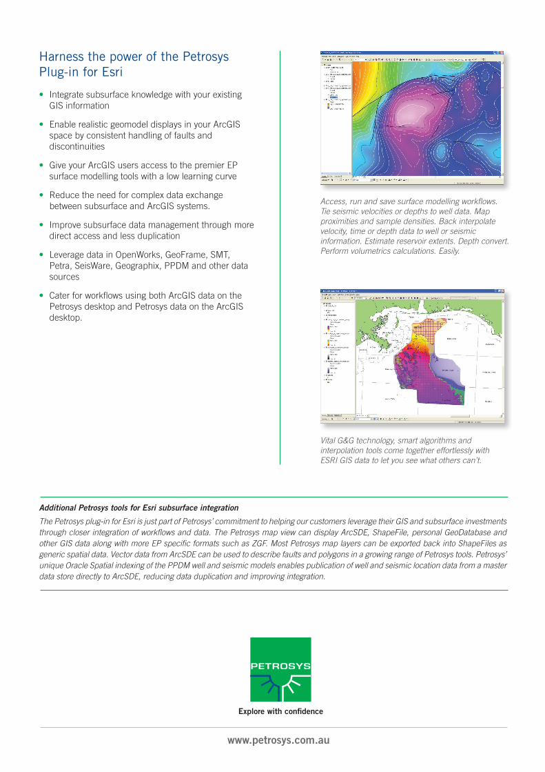
Access, run and save surface modelling workflows. Tie seismic velocities or depths to well data. Map proximities and sample densities. Back interpolate velocity, time or depth data to well or seismic information. Estimate reservoir extents. Depth convert. Perform volumetrics calculations. Easily.
Vital G&G technology, smart algorithms and interpolation tools come together effortlessly with ESRI GIS data to let you see what others can’t.
Harness the power of the Petrosys Plug-in for Esri
• Integrate subsurface knowledge with your existing GIS information
• Enable realistic geomodel displays in your ArcGIS space by consistent handling of faults and discontinuities
• Give your ArcGIS users access to the premier EP surface modelling tools with a low learning curve
• Reduce the need for complex data exchange between subsurface and ArcGIS systems.
• Improve subsurface data management through more direct access and less duplication
• Leverage data in OpenWorks, GeoFrame, SMT, Petra, SeisWare, Geographix, PPDM and other data sources
• Cater for workflows using both ArcGIS data on the Petrosys desktop and Petrosys data on the ArcGIS desktop.