13
July 30, 2015 Prepared By U.S. Army Corps of Engineers St. Louis District PHASE I ENVIRONMENTAL SITE ASSESSMENT FOR Crains Island Wildlife Refuge Rehabilitation Middle Mississippi River

July 30, 2015
Prepared ByU.S. Army Corps of Engineers
St. Louis District
PHASE IENVIRONMENTAL SITE ASSESSMENT
FOR
Crains IslandWildlife Refuge Rehabilitation
Middle Mississippi River
Prepared for:U.S. Army Corps of Engineers
St. Louis District1222 Spruce Street
St. Louis, MO 63103
Approved by:
Kevin P. SlatteryChief, Environmental Quality Section
I declare that, to the best of my professional knowledge and belief, I meet the definition ofEnvironmental Professional as defined in 40 CFR 312.10. I have the specific qualificationsbased on education, training, and experience to assess a property of the nature, history, andsetting of the subject property. I have developed and performed the all appropriate inquiries inconformance with the standards and practices set forth in 40 CFR Part 312.
Richard D. ArcheskiEnvironmental Engineer
Phase I – Environmental Site Assessment
Crains Island Wildlife Refuge Rehabilitation Middle
Mississippi River

Table of Contents
Executive Summary
I. Introduction
1.1 Purpose
II. Project/Site Description
2.1 Location Description2.2 Site/Vicinity Characteristics
III. User Provided Information
IV. Records Review
4.1 Historical Use Information
V. Site Reconnaissance
VI. Interviews
VII. Findings
VIII. Data Gap
IX. Opinion
X. Conclusions
XI. Limitation
XII. References
XIII Qualifications

Appendices
Appendix A Environmental Records
Appendix B Historical Data
Appendix C Photographs
Appendix D Threatened and Endangered Species
Appendix E Clean Water Act
Appendix F National Response Center (NRC) Report
Appendix G Interview Questionnaire

Executive Summary
A Phase I Environmental Site Assessment was conducted for the Crains Island Complex.This area is part of the Middle Mississippi River National Wildlife Refuge (MMRNWR). The Crains Island Complex includes 553 acres and is located approximately 4 miles southwest of the City of Chester, in Randolph County, Illinois on the right descending bank of the Mississippi River between river miles 103 and 106. This project is designed to restore approximately 2 milesof side channel island habitat, and improve the quality of existing secondary channel habitat.The U.S. Fish and Wildlife Service (USFWS) manages Crains as part of the Middle MississippiRiver National Wildlife Refuge (MMRNWR). This due diligence effort is intended to provide the minimum information required to assess potential environmental liabilities associated withthese sites.
The objective of the Phase I is to identify, to the extent feasible pursuant to the processdescribed herein, recognized environmental conditions (RECs) in connection with a givenproperty(s). This assessment revealed no RECs in connection with this project.
I. Introduction
1.1 Purpose
The U.S. Army Corps of Engineers (USACE) regulations (ER 1165-2-132 andER 200-2-3), and District policy requires procedures be established to facilitate earlyidentification and appropriate consideration of potential hazardous, toxic, or radioactivewaste (HTRW) in reconnaissance, feasibility, preconstruction engineering and design,land acquisition, construction, operations and maintenance, repairs, replacement, andrehabilitation phases of water resources studies or projects by conducting HTRW InitialHazard Assessments (IHA). USACE specifies that these assessments follow theprocess/standard practices for conducting Phase I Environmental Site Assessments (ESA)published by the American Society for Testing and Materials (ASTM).
This assessment was prepared using the following ASTM Standards:
E1527-13: Standard Practice for Environmental Site Assessments – Phase IEnvironmental Site Assessment process
E1528-06: Standard Practice for Limited Environmental Due Diligence:Transaction Screen Process (interview questionnaires)
E2247-08 Standard Practice for Environmental Site Assessments: Phase IEnvironmental Site Assessment Process for Forestland or Rural Property

The purpose of a Phase I ESA (IHA) is to identify, to the extent feasible in theabsence of sampling and analysis, the range of contaminants (i.e. RECs) within the scopeof the U.S. Environmental Protection Agency’s (EPA) Comprehensive EnvironmentalResponse, Compensation and Liability Act (CERCLA) and petroleum products.
The scope of this Phase I consist of the following four components:
a. Records reviewb. Site reconnaissancec. Interviewsd. Report
II. Project/Site Description
2.1 Location Description
The Middle Mississippi River National Wildlife Refuge (MMRNWR) is locatedin southeast Missouri and southwest Illinois on the un-pooled section of the MississippiRiver and encompasses approximately 7,000 acres of riverine, floodplain forest, andwetland ecosystems. The MMRNWR extends 195 river miles from the confluence of theMissouri River at St. Louis south to the confluence of the Ohio River at Cairo, Illinois.The refuge is located in the first section of the Mississippi River downstream of the lockand dam system in the area known as the Middle Mississippi River Regional Corridor.Crains Island is located approximately 4 miles southwest of the City of Chester, in Randolph County, Illinois on the right descending bank of the Mississippi River betweenriver miles 103 and 106. The U.S. Fish and Wildlife Service (USFWS) manages Crains Island as part of the MMRNWR. See figure 1 for site location.
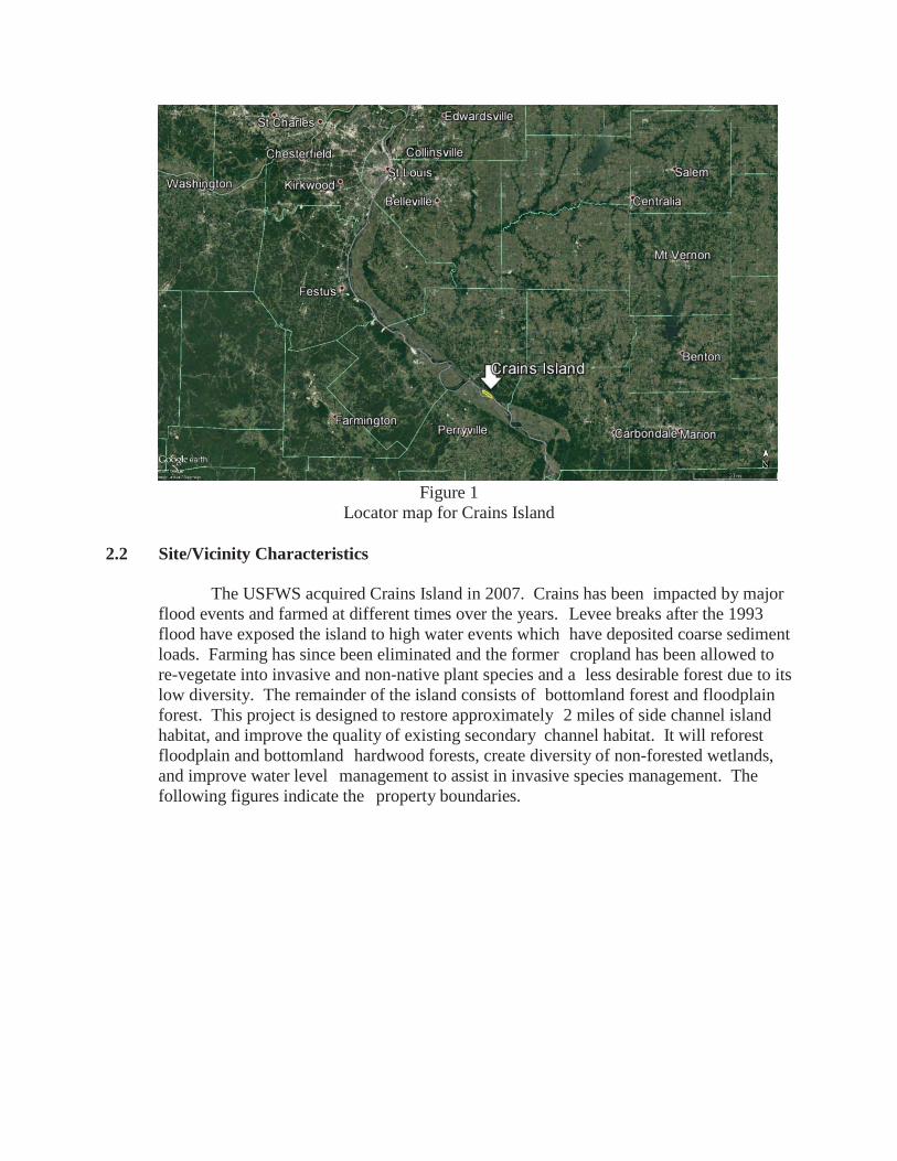
Figure 1Locator map for Crains Island
2.2 Site/Vicinity Characteristics
The USFWS acquired Crains Island in 2007. Crains has been impacted by major flood events and farmed at different times over the years. Levee breaks after the 1993flood have exposed the island to high water events which have deposited coarse sediment loads. Farming has since been eliminated and the former cropland has been allowed to re-vegetate into invasive and non-native plant species and a less desirable forest due to its low diversity. The remainder of the island consists of bottomland forest and floodplain forest. This project is designed to restore approximately 2 miles of side channel island habitat, and improve the quality of existing secondary channel habitat. It will reforestfloodplain and bottomland hardwood forests, create diversity of non-forested wetlands,and improve water level management to assist in invasive species management. The following figures indicate the property boundaries.

Crains Island Division (553 acres)
Crains Island Division is located in Randolph County, Illinois, between RM103 and 106 RDB. This division has a CAAB of 958 acres. With the currentfee-title holdings of 553 acres, it is 58% acquired. Acquisition in 2007 allowedthe Refuge to conserve a remnant braided island/side channel complex locatedjust across the river from Chester, Illinois. Situated on the river side of the

levee in Missouri, the frequently flooded division is a mosaic of remnant oxbows, sloughs, riverfront forests, and secondary river channels. This division was once bordered by the Missouri Chute, an area where the Mississippi River once meandered.Missouri Chute is now used as a drainage ditch in support of the Bois Brule Levee andDrainage district objectives. The purposed project for Crains Island includesexcavation and reconnection of 2 miles of side channel, and reforestation of 75 acres.
III. User Provided Information
Site visits, records search, and personal interviews with persons familiar with thearea and local hazardous response personnel revealed the remote possibility ofencountering HTRW issues. The environmental impact for the migration of off-sitecontaminants onto the project property is negligible. However, located next to a majorriver does expose these properties to potential debris drifting down the river from either aspill or flood event.
IV. Records Review
For the purpose of this Phase I, the following standard records sources wereobtained and reviewed to assist in the identification of potential REC’s in connectionwith this project:
National Response Center (NRC)Historical Aerial PhotographsUSACE Historical InformationHistorical Topographic MapsUSFW Service
These records assist in meeting the requirements of EPA’s Standards andPractices for All Appropriate Inquires (40 CFR Part 312), and the ASTM StandardPractice for Environmental Site Assessments (E 1527-05). For properties that containedinadequate address information for mapping purposes, reasonable efforts were made toidentify the approximate location of the sites in relation to the target properties as part ofthe review process. In addition, the physical setting was assessed for the target propertiesby reviewing topographic maps to identify conditions in which hazardous substances orpetroleum products could migrate.

4.1 Historical Use Information
The following available historic information sources were obtained and reviewed:The following historical aerial photographs were reviewed:
1940, 1956, 1980, 1988, 1991, 1993, 1996, 1998, 2005, 2007, 2009, 2011, and 2014
The following historical topographic maps were reviewed:1915, 1918, 1948, 1968, 1970, 1990, 1993, and 1994
Crains Island formed relatively recently with the earliest available maps dated in 1815. Through the shifting of the Mississippi River, erosion, and buildup of the island,construction of dikes in the 1920s and 1930s, the current island boundary did not take shape until the 1960s. There is no known prehistoric occupation of the island, but a detailedarchaeologically survey has not been conducted. Early aerial photography indicates theentire island was cultivated. The island was cultivated until 2007 when the Fish andWildlife Service purchased the property and taken out of cultivation.
Seventeen vessels have been recorded as being wrecked in the vicinity Crains Island.The nearest known historic wreck is over 1.5 miles away. The nearest known modern wreckis over 3.5 miles away.
No sanborn maps were available for these areas. Review of land use maps revealthat the majority of land adjacent to the project is rural and has been vacant or used foragriculture. The Middle Mississippi River National Wildlife Refuge Habitat ManagementPlan dated October 2012 was used as a reference.
V. Site Reconnaissance
A site visit to Crains Islands was conducted on 29 January 2015 by Mr. RickArcheski and Michael Henry of CEMVS-EC-EQ. In addition, the surrounding adjacentproperties were also inspected as part of this survey. Photographs documenting the site visit are enclosed as appendix C.
VI. Interviews
Interviews were conducted in order to obtain information indicating RECs inconnection with this site. The content of the questions asked followed the questionnaireformat of ASTM 1528. The questionnaire is attached to Appendix G. Interviews wereconducted with the following persons:
Jason Wilson – U.S. Fish and Wildlife Assistant Manager Mississippi RiverNational Wildlife RefugeJohn Hartleb Wildlife Refuge Specialist Middle Mississippi River NationalWildlife Refuge
VII. Findings
Crains Island:
Illinois Department of Transportation is listed as an IL SWF/LF approximately 2 milesof the site. This is not considered a REC.

Ford Dock Inc. is listed as a US MINES site approximately 1.75 miles from thesite.
Lone Eagle Dock is listed as a FINDS, IL AIRS and US AIRS approximately 1.5miles from the site.
Two sites are listed as IL CDL (Meth Drug Lab), one in Highland and one in Chester.
During the site visit a transformer on a pole near the pump stations was identified. The transformer on the pole near pump stations at south end of Crains Island is in good conditionand confirmed by Citizens Electric Company in Perryville, Missouri to be PCB free. Nostaining around base of pole. This is not considered a REC.
Two 2,000 gallon diesel aboveground storage tanks at pump houses near south end ofCrains Island. This is not considered a REC.
Debris from flood events or dumping by local residents was present on the island.
Standard agricultural chemicals were probably used at some time. However, farmingpractices have been halted for 8, and flood events have probably leached most of thechemicals from the soil.
Interviews with the manager indicated that no spills have occurred in the recent past.
U.S. EPA’s Enforcement and Compliance History Online (ECHO) did not indicate any violations.
Generally, the project area contains no sites of interest, which pose significantenvironmental concerns.
Potential RECs on adjoining or nearby properties are either considered de minimus or only potential RECs that are not expected to impact these sites due to the distance ortopographic features.
Currently the only real potential of RECs is from dumping of solid waste by localresidents or debris drifting down the river from either a spill or flood event.
According to the NRC there were 43 incidences that took place from 2005 to 2015that occurred above Crains Island. The majority occurred in Jefferson County, Missouriand Randolph County, Illinois. A listing of these incidences is contained in Appendix F.
VIII Data gaps
Due to the large volume of the NRC report, only the last ten years were reviewed.
IX. Opinion
An Environmental Site Assessment was conducted in conformance with the scope andlimitations of ASTM Practice E for the Crains Island Complex. This assessment has revealedno RECs that will affect the project in connection with the property.

X. Conclusions
An Environmental Site Assessment Phase I ESA was conducted in accordancewith the scope and limitations of ASTM Practice E 1527 for Crains Island. The assessment revealed no RECs in connection with the property.
XI. Limitations
U.S. Army Corps of Engineers, Environmental Quality Section, should becontacted with any known or suspected variations from the conditions described herein.If future development of the property indicates the presence of hazardous or toxicmaterials, USACE should be notified to perform a re-evaluation of the environmentalconditions.
The scope of this assessment did not include any additional environmentalinvestigation, not outlined herein, or analyses for the presence or absence of hazardous ortoxic materials in the soil, ground water, surface water, or air, in on, under or above thesubject tract.
This site assessment was performed in accordance with generally acceptedpractices of consultants undertaking similar studies at the same time and in the samegeographical area, and USACE observed that degree of care and skill generally exercisedby consultants under similar circumstances and conditions. The findings and conclusionsstated herein must be considered not as scientific certainties, but rather as professionalopinions concerning the significance of the limited data gathered during the course of theenvironmental site assessment. No other warranty, express or implied, is made.
Specifically, USACE does not and cannot represent that the site contains nohazardous waste or material, oil (including petroleum products), or other latent conditionbeyond that observed by USACE during its site assessment.
The observations described in this report were made under the conditions statedherein. The conclusions presented in the report were based solely upon the servicesdescribed therein, and not on scientific tasks or procedure beyond the scope of describedservices or the time and budgetary constraints imposed by the client. Furthermore, suchconclusions are based solely on site condition, and rules and regulations, which were ineffect, at the time of the study.
In preparing this report, USACE relied on certain information provided by stateand local officials and other parties referenced therein, and on information contained inthe files of state and/or local agencies available to USACE at the time of the siteassessment. Although there may have been some degree of overlap in the informationprovided by these various sources, an attempt to independently verify the accuracy orcompleteness of all information reviewed or received during the course of this siteassessment was not made.

Observations were made of the site and of structures on the site as indicatedwithin the report. Where access to portions of the site or to structures on the site wasunavailable or limited, USACE renders no opinion as to the presence of indirect evidencerelating to hazardous waste or material or oil, or other petroleum products in that portionof the site or structure. In addition, USACE renders no opinion as to the presence ofhazardous waste or material, oil or other petroleum products or to the presence of indirectevidence relating to hazardous material, oil, or petroleum products where directobservation of the interior walls, floor, roof, or ceiling of a structure on a site wasobstructed by objects or coverings on or over these surfaces.
Unless otherwise specified in the report, USACE did not perform testing oranalyses to determine the presence or concentration of asbestos, radon, formaldehyde,lead-based paint, lead in drinking water, electromagnetic fields (EMFs) orpolychlorinated biphenyls (PCBs) at the site or in the environment at the site.
The purpose of this report was to assess the physical characteristics of the subjectsite with respect to the presence in the environment of hazardous waste or material, oil, orpetroleum products. Except as otherwise described in this report, no specific attempt wasmade to check on the compliance of present or past owners or operators of the site withfederal, state, or local laws and regulations, environmental or otherwise.
XII References
E1527-13: Standard Practice for Environmental Site Assessments – Phase IEnvironmental Site Assessment Process, ASTM
E1528-06: Standard Practice for Limited Environmental Due Diligence: TransactionScreen Process (interview questionnaire), ASTM
E2247-08 Standard Practice for Environmental Site Assessments: Phase IEnvironmental Site Assessment Process for Forestland or Rural Property
XIII Qualifications
USACE EC-HQ has the specific qualifications based on education, training andexperience to assess a property of the nature, history, and setting of the subject propertiesand declare that, to the best of our professional knowledge and belief meet the definitions ofEnvironmental Professionals as defined under 40 CFR 312.


