BABEŞ-BOLYAI UNIVERSITY FACULTY OF GEOGRAPHY PHD THESIS Abstract THE RELATIONSHIP BETWEEN RELIEF AND TOURISM IN THE TRASCǍU MOUNTAINS Scientific coordinators: PhD Candidate: Prof.dr. V. SURDEANU GABRIELA COCEAN Prof. D. CASTALDINI Cluj Napoca 2011
Transcript
BABEŞ-BOLYAI UNIVERSITY FACULTY OF GEOGRAPHY
PHD THESIS Abstract
THE RELATIONSHIP BETWEEN RELIEF AND TOURISM IN THE TRASCǍU MOUNTAINS
Scientific coordinators: PhD Candidate: Prof.dr. V. SURDEANU GABRIELA COCEAN Prof. D. CASTALDINI
Cluj Napoca 2011
THESIS STRUCTURE The geographic location and unit limits
1. THEORETICAL BASES AND METHODOLOGY OF THE STUDY 1.1. Particularities of the relief-tourism relationship 1.2. Relief and tourism – a topic of scientific debate 1.3. Methodology of the approach
5. CORRELATIONS BETWEEN THE MORPHOGENESIS, MORPHOMETRY, MORPHOLOGY OF RELIEF AND TOURISTIC ATTRACTIVENESS
5.1. Morphogenesis and touristic attractiveness 5.2. Morphometry’s touristic role 5.3. Morphology and touristic attractiveness 5.4. Attractive outshine phenomenon
6. TOURISTIC FUNCTIONS OF RELIEF 6.1. Relief as an attractive resource 6.1.1. Scarps 6.1.2. Ridges 6.1.3. Karstic gorges 6.1.4. Gorges in other types of rocks 6.1.5. Swallets 6.1.6. Caves and pit caves
6.1.7. Isolated massifs 6.1.8. Waterfalls 6.1.9. Morpho-touristic landscapes 6.2. Relief as scenery background 6.2.1. Features of the background landscape 6.2.2. Hypostases of the morphological background 6.3. Relief as support of infrastructure and touristic activities
6.3.1. Accommodation and catering infrastructure 6.3.2. Recreational infrastructure
6.3.3. Access roads 6.3.4. Guiding and tourist information endowments 7. GEOMORPHOSITES
7.1. General aspects 7.2. The assessment method 7.3. Inventory cards for geomorphosites
8. TYPES AND FORMS OF TOURISM DETERMINED BY RELIEF 8.1. Recreational tourism
9.2. Anthropogenic risks 9.2.1. Industrial exploitation 9.2.2. Risks derived from pastoral land use 9.2.3. Infrastructure built within the perimeter of geomorphosites 9.3. The impact of touristic activities on the landscape
9.3.1. Damages to the integrity and aesthetics of morpho-touristic attractions 9.3.2. Degradation of landscape aesthetics 9.3.3. Touristic pollution
9.4. Mitigation measures and solutions 10. The arrangement of touristic attractions
10.1. The current situation of endowments 10.2. The arrangement of morphological attractions: solutions and proposals
When analyzing the relief-tourism relationship, one can easily note the double interaction between these two components: relief can generate tourism and can influence its development, hosting the constituent elements of the tourist infrastructure, while tourism has an impact upon relief, both through its facilities and conduct of the individual practitioner of the activities concerned.
Analyzing the structure of touristic resources one can note that among the elements of the environment, relief has the most significant weight, often being classified as the top attractive resource. This first rank is conferred by the many major and minor forms of special attractive value: scarps, ridges, glacial forms, gorges and defiles, caves and pit caves, volcanic cones and craters, deltas, sinkholes, differentiated forms of erosion etc., elements that can generate and develop the touristic phenomenon in a certain area.
Even when, due to its morphological features, relief fails to become a primal touristic resource, it is still a touristic resource of secondary importance, as part of the overall landscape of another resource (hydrographical or of anthropogenic origin, for example) providing harmony, diversity and contrast, which makes it a background resource.
Finally, relief provides the physical base of tourism, on which touristic infrastructure, accommodation facilities, restaurants and access roads are located. On the other hand, relief may also act as a limiting factor, preventing the development of some touristic attractions (areas with landslides, increased erosion, mobile sands etc.).
There are many interesting approaches to the relief’s role in tourism development in the Romanian literature: Rădulescu (1966), Grigore (1974), Swizewski and Oancea (1977). Popescu-Argeşel (1977), Cocean (1984, 1996, 1997, 2010), Ciangă (1996, 2001, 2006), Muntele and Iaţu (2006), Dinu and Peţan (2005), Cândea and Simion (2006), Irimuş (2010). These authors analyze the participation of relief to the genesis of tourism, its role and functions, often exemplifying using morphological attractions located in the our study region. There are also some attempts of touristic regionalization, and classifications of morphological resources situated in the area.
A special category of papers related to the Trascău Mountains is represented by travel guides, focused either on the entire massif (Măhăra, Popescu-Argeşel, 1993), or on some units of it. Well known are the guides of Turzii Gorges, written by Pop and Barna (1971), Vasile and Barbelian (1986), and those of the Arieş Valley (Puşcariu and Rusu, 1969; Popescu-Argeşel, 1984).
A line of investigation of recent date, with wide meanings for the study of the relief-tourism relationship is the study of geosites and geomorphosites.
The first studies of geomorphosites have been conducted in Italy, Switzerland, Britain and Spain in the early ‘90s, later becoming an area of concern for more geomorphologists, including those in Romania. These studies were conducted by a rather long list of geographers and geologists like Reynard (2002, 2004, 2008, 2009), Pralong (2004), Panizza (2001), Panizza and Piacente (2003), Wimbledon (1996), Grandgirard (1997, 1999), Avanzini et al. (2002), Poli (1999), Brancucci and Burlando (2001), Serrano (2002). Bertacchini (1996), Piacente (2001), Brancucci, (2003), De Waele et. al. (2004) Piccini et. al. (2005), Hoblea (2009), Dowling and Newsome (2006, 2008) who defined the concepts, developed evaluation methods and prefigured geomorphosites hierarchies. In Romania, the issue was brought from the “Italian school" by Ilieş and Josan (2007, 2008, 2009), and was later approached by other
geographers (Ielenicz, 2009), etc. Methodology of the approach
The methods used in the writing of this thesis, naturally unite elements from both Geographical Sciences: Geomorphology and Geography of Tourism.
When it comes to the geomorphosite selection and assessment methodology, one can note the absence of a generally accepted method within the scientific community. Primarily, this is due to the fact that the ultimate goals of the researchers differed from study to study; secondly, the regions in which the methods were applied, containing different geomorphosites, might have required specific criteria.
Among the first inventory methods of landforms as part of the geological-geomorphologic heritage is the one proposed by Panizza and Cannillo (1994). The authors elaborated a synthetic sheet, seeking a genetic classification of the landform, location, selection criteria, the degree of interest, a brief description of lithology and geomorphology. The selection criteria were divided into two groups: the main ones, treating the geological and geomorphologic evolution, the didactic exemplarity, the paleogeographical valences and the degree of rarity and uniqueness, and the integrative ones, referring to cultural, aesthetics and ecological valences of the landforms
Among the assessment methods, the most popular five are those of the Geosite work group members from the universities of Modena (Coratza and Giusti), Cantabria (Bruschi and Cendrero), Valladolid (Serrano and Trueba), Lausanne (Reynard) and Minho (Pereira). The method proposed by Pralong (2005) is also of high interest.
In this thesis, GIS mapping was extensively and effectively used in the accumulation, storage, and systematization and processing of information.
CORRELATIONS BETWEEN THE MORPHOGENESIS, MORPHOMETRY, MORPHOLOGY OF RELIEF AND TOURISTIC ATTRACTIVENESS
Morphogenesis and touristic attractiveness
Among the correlations that can be established between the genesis or the evolution of landforms and tourism, the ones that are of utmost importance for the Trascău Mountains are those between tourism and the existence of gorges, caves, sinkholes, klippes and other isolated massifs and morphological vestiges such as arches and natural bridges.
The genesis of gorges, the best represented group of morphological attractions in the Trascău Mountains (constituting, at a rough estimate, over 60% of the attractive potential of the unit), hides very interesting issues that need to be brought to the attention of tourists in a accurate but also exciting manner.
Thus, for the antecedent gorges (Feneşului and Ampoiţei) the justification of their attractiveness is represented by the preservation of the river route in the context of the massive tectonic lift. The phenomenon appears to be the result of a fierce competition between an aggressive and destabilizing endogenous factor and the obstinacy of the drainage network to keep deepening.
Epigenetic gorges are the most common in the Trascău Mountains. Their genesis begins with the organization of the runoff on soft, easily removable, sedimentary structures. By deepening, rivers intersect harder lithological layers, in this case, Jurassic limestones and ophiolites. Instead of avoiding these rocks and further exploiting the opportunities provided
by the soft layers, the rivers continue the erosion in these resistant rocks, carving narrow and beautiful valleys. Turenilor, Turzii, Borzeştilor, Aiudului, Mănăstirii, Geogelului, Găldiţei or Galdei gorges, as well as Turului, Hăşdatelor, Borzeştilor, Rachişului, Râmeţului, Galdei, Ţelnei sau Bucerdei defiles were born in this way.
Much more interesting is the correlation between karstic capture gorges and tourism, the processes involved in this genesis being more complex and more spectacular. In the Trascău Mountains, there are two such gorges, Râmeţ and Întregalde, with quite remarkable landscape and touristic attractiveness. Their genesis begins with the ramble of a fraction of water in the underground and the formation of an aquifer in the limestone massifs. This aquifer later reaches to the opposite slope, therefore opening an active drain. Downstream of the capture point, the old valley remains dry, while the underground gallery continues to enlarge, reaching the stage of a cave. As the river deepens in the new channel and the endokarstic form enlarges, collapsing of the cave ceiling increases. In the same time, the exogenous denudation acts on the above layers. As a result, the cave ceiling gets thinner and the cave turns into an authentic gorge.
Fig. 1. Genesis of karstic capture gorges. A. First stage, the formation of endokarstic aquifers; B. the stage of the cave; C. the stage of the transformation of the cave into a gorge. 1. limestones; 2. sedimentary rocks; 3. underground aquifer; 4. natural bridge.
Speleogenesis also exemplifies the complex relationship between dissolution relief
and tourism, with an unmatchable attractive effect. Caves have a series of attractive attributes, like the dimensions and physiognomy, the presence of speleothemes, underground rivers, lakes or waterfalls, archaeological and paleontological vestiges, curative climate (Cocean, 1995) etc.
Other attractive landforms, due to their unique genesis, are swallets. One of the most spectacular swallets in the Apuseni Mountains and the whole Romanian karst, The Vânătara Swallet, is located in this area. The impressive antithetical steep, the surrounding morphological diversity are the Valea Poienii waterfall are all elements that maximize its attractiveness. Morphometry’s touristic role
Analyzing this aspect one can easily notice that the higher a landform is, the more attractive it is. Thus, the height of various landforms contributes to tourism potential through the following attributes:
The lookout function of the relief - is ensured by the relative altitude of landforms, the angle of perception being much more open as the difference in level between landforms is bigger and the spatial deployment of lower altitude units is wider.
Thus, the Trascău Mountains, because of the altitudes of the main ridge and its relations with neighboring relief units, has a privileged position. This residual, suspended
massif, has level differences in relation to the surrounding valleys and depressions reaching up to 800 m - a notable difference, which has the most favorable impact, by offering tourists a vast view of the adjacent units.
The island effect is an altimetric induced effect that appears in the case of some landforms of residual character, Ciumerna-Bedeleu or Pleaşa Râmeţului- Piatra Cetei ridges, and of isolated massifs that rise from the blanket of sedimentary rocks. The altimetric dominance of these landforms marks them in the mind of the viewer, and concentrates the tourists’ attention and curiosity upon them. But, this altimetric detachment brings along other features, such as the difficult access, a fact that made them suitable for providing shelter in older times, and were therefore exploited by building fortresses (most relevant examples being the Dacian fortress of Piatra Craivii, and the Colţeşti medieval fortress located on a prominent rock counterfort in the Trascău Depression).
Altitude and aerotheraphy. A territory’s morphometry has a variety of climatic consequences, some of them directly influencing tourism. There is the inverse correlation between the increasing altitude and decreasing temperature, the vertical gradient being of approx. 0.8-1°C to 100 m. As a result, on the high part of Bedeleu, at over 1250m altitude, the average air temperature, of 2-4°C, is approx. 6-7°C lower than in the Mureş lane, thus creating favorable conditions for aerotheraphy.
Morphometry, with its sudden difference in height levels between forms, also provides favorable conditions for the practice of extreme sports such as paragliding. The most favorable locations for such activities are the isolated massifs as well as the altimetric detached ones, Colţii Trascăului, Rachiş, Data, Piatra Craivii etc. Culmea Petridului (the western scarp) and Piatra Cetii are also suitable for these activities. Morphology and tourist attractiveness
Really attractive morphological traits refer to the objectives’ uniqueness, originality, structural complexity, diversity, scale, vertical development, physiognomy etc.
The uniqueness of landforms gives the tourist the comforting feeling of meeting an absolute rarity, something unprecedented, never seen before. Uniqueness may result either by the modeling of a single specific form or by the destruction or loss of all other similar forms. The former category includes the unique development of the Borzeştilor Gorge, sculpted by a river system whose direction flow changed because of the capture phenomenon: initially, the Borzeştilor Valley was drained from south to north, towards the Borzeştilor Bay, but was later captured by the Arieş’s affluent, who changed the direction of its drainage from north to south. Another unique example is the correspondence between the Cetăţeaua Mare and Cetăţeaua Mică caves in the Turzii Gorge, as segments of a cave gallery divided by the Hăşdatelor Valley.
The frequent association, along the same stream, such as the Râmeţ or Galda, of gorges and defiles sectors, is also an unprecedented appearance in the morphology of the Apuseni Mountains and even in our country. The landscape of isolated massifs and klippes of the Ampoi-Ampoiţa-Ighiel-Galda-Râmeţ area can also be considered unique, in terms of density, diversity and physiognomy.
The novelty of landforms refers to various aspects such as: physiognomy, dimensional, positional or functional aspects. These aspects strike the eye, and incite curiosity through deviation from the ordinary. The constant association of limestone and ophiolites generating the morphological diversity in Colţii Trascăului; the mosaic morphology in the Tureni, Turzii, Râmeţului, Întregaldelor gorges; the erosion marmites in the Cetei or Geogelului gorges; the median marmite of the Valea Poienii waterfall; the travertine cone of Şipote Waterfall; the arches of Colţii Trascăului, or the Turzii and Întregaldelor gorges; the
natural bridge from Râmeţului Gorge, can all be considered elements of novelty. The structural complexity of major and minor landforms is an important factor,
displaying the cohabitation of multiple genetic factors, several evolutionary trends and several qualities which arouse the interest of tourists. One such landform is the Huda lui Păpară cave, whose various morphology, the succession of large rooms (Minunilor, Tăcerii, Virgină) and narrow passages, of sectors carved by corrosion with those fashioned by erosion, of calcitic deposits with erosional and tectonic-gravitational formations, of vadose sections with flooded ones etc., becomes an attractive resource of the highest rank The most important gorges (Turzii, Râmeţului, Întregaldelor) can also be included in this category, due to slopes, caves, natural arches and other minor elements of interest.
Typological diversity serves to remove the monotony. The more diversity an area displays, the more the attractiveness index increases and vice versa. In the Trascău Mountains more than in any other unit of the Romanian Carpathians, the typological diversity is well ensured by the lithologic diversity that has determined the current landscape, limestone, ophiolites, crystalline schists, conglomerates, sandstones, and clays. The presence of at least five types of petrographic relief, among which the landforms modeled on limestones and ophiolites are well detached, the classic fluvial and periglacial relief, the relevant examples of structural relief, all contribute to shaping the Trascău Mountains as an outstanding area for the development of tourism.
Dimensional relations of the morphological elements are also a source of attractiveness. In general, the oversized, widely developed landforms enjoy a special interest and attraction. The grand dimensions of Huda lui Papară and Poarta Zmeilor caves, the great verticals of the Dâmbău and Gemenele pit caves, the height of the antithetical steep of the Ponorului Vânătara, the great length, over 30 km of the Arieşului Gorge etc., are all such motivations of tourism demand.
The vertical display of landforms, such as the slopes from most gorges, the side slopes of the karstic plateaus and ridges (Ciumerna, Bedeleu, Colţii Trascăului, Pleaşa Râmeţului-Piatra Cetei) or isolated massifs (Piatra Craivii, Corabia-Dâmbău, Pietrele Ampoiţei etc.), provides a high attractiveness index to the area. These slopes, regardless of origin (tectonic or erosional) or their location determine a unique form of leisure tourism: climbing. The great number of climbing routes in the Trascău Mountains and the high difficulty degree of some of those are to be taken into consideration in tourism development strategies for the area.
The physiognomy of landforms, with special reference to the minor ones, plays an important part in the richness of the touristic offer. Grooved, stellar or tubular karren; circular or ovoid dissolution sinkholes as opposed to funnel-shaped collapse ones; deviated stalactites (anemoliths) from the Huda lui Papară Cave; "mushrooms" or "babele" shaped alteration-disintegration residual relief; the winding vertical profile specific to some sectors of certain gorges (Râmeţului, Cetei) – all reflect the mark of the morphology over the landscape and relate directly to its attractiveness. The attractive outshine phenomenon
The attractive outshine is the phenomenon that tends to depreciate some features of the touristic attractions when compared to others, considered as a standard. For the touristic resources belonging to the landscape, the attractive outshine might be determined by another resource’s more privileged location, dimensional features, landscape aesthetics, structural complexity, physiognomy, detail morphology, colors, etc. In this specific case, this phenomenon has particular features: thus one can distinguish an objective outshine, caused by the morphological features, and a subjective outshine, derived from the differential display of
elements, accessibility or even personal choices of tourists. The objective attractive outshine phenomenon occurs in various instances, and can
be determined by a number of factors among which the most prominent are: altimetric dominance, vertical display of forms, novelty elements and variety of morphological details.
Generally, the altimetric difference among relief types is the result of the geological structure and of the specific processes of selective denudation. The hard rocks, more resistant to erosion, can be identified in the residual forms, strikingly imposed in the landscape. In these circumstances, limestone, although subject to both erosion and dissolution, is more resilient in comparison with adjacent sandstones and conglomerates.
On the other hand, the vertical dimension of landscape elements is far more attractive relative to their horizontal arrangement. The impact on the viewer is immediate, and the interest for that morphological element is triggered by the first visual contact. By their unusual occurrence in the landscape, the isolated massifs and klippes generate a classic “island effect” of certain attractiveness.
There is, in the Trascău Mountains, the tendency of some types of relief to eclipse others. Thus, karst, by its residual character, is altimetric dominant towards the close ophiolites formations, and more so, towards the sedimentary rocks. A second form of this type of objective outshine is of morphological nature, the richness and diversity of karstic forms overcoming in terms of attractiveness, the forms shaped into ophiolites, crystalline and sedimentary rocks.
Another form of the attractive outshine can be noted within the same group of morphological elements. Among caves, for example, the most developed ones, with major attractive features will outshine the small cavities with modest calcite deposits, although their number in considerable. Thus, Huda lui Papară is eclipsing all other natural cavities in the Trascău Mountains, because of its development of 5200m, dimensions of the insurgence and resurgence, and particular underground landscape.
Likewise, Turzii Gorge outshines the nearby Turenilor and Borzeştilor gorges, Vălişoarei Gorge outshines a number of smaller gorges carved in the eastern Bedeleu (Plaiului, Siloşului, Pleşii, Drăgoiului şi Bedeleului) etc. The outshine occurs also on valleys that contain more gorge sectors, Întregaldelor Gorge outshining the Galdei and Galdiţei gorges, the same way as the Râmeţ Gorge does with the Mănăstirii, Geogelului, Pravului and Piatra Bălţii ones.
Subjective outshine phenomenon is determined by a number of attributes granted by the personal options of tourists as well as conscious expectations of the tourist demand in general, based on specific recreational, cultural or curative options. Most of them are based on issues outside the morphological context and are due to the intervention of tourism promoters, which can generate a phenomenon of outshine with the selection of specific locations to be promoted, locations that, therefore, receive a better display.
The subjective eclipse is also due to higher accessibility and differentiated endowment. A good example is provided by the karstic ridges Pleaşa Râmeţului-Prisaca-Piatra Cetii and Colţii Trascăului. The first one totals 15km and reaches a height exceeding 1200m in altitude. The slopes, towers, karren, all create a very impressive landscape. Colţii Trascăului has a more modest length, of a maximum of 5km, with the maximum altitude of 1128m, but with a similar relative altitude, therefore being a relevant lookout point. Still, Colţii Trascăului tends to eclipse "by far" the other unit. The reasons are found both in touristic promotion for the area, and, especially in the easier and faster access to the Trascău Depression.
Subjective outshine is also due to the personal options of the tourist. This may occur when the tourist has other preferences than those provided by the resource considered to be more attractive.
TOURISTIC FUNCTIONS OF RELIEF
Relief as an attractive resource
Analyzing the morphology of the Trascău Mountains, one can note that some of the
morphological elements represent outstanding tourist attractions, due to their physiognomy, size, genetic and functional features; among them, we can identify scarps, ridges, gorges and defiles, swallets, caves and pit caves, isolated massifs, periglacial forms etc.
Scarps are striking morphological elements because of the harsh connection they create between two horizontal surfaces and of course, due to their vertical development. They provide a grandeur and an original note to the landscape, which can be most favorably perceived by tourists. Depending on their location in the Trascău Mountains we distinguished three distinct types of scarps: steep peripheral scarps of limestone ridges, scarps within gorges and canyons and scarps located on isolated massifs.
Ridges are landforms resulted from the direct intersection of two slopes, which led to the individualization of a sharp ridge. There are two typical ridges in the Trascău Mountains: Pleaşa Râmeţului-Prisaca-Piatra Cetii and Colţii Trascăului.
Gorges represent one of the most attractive morphological resources for tourism, due to their considerable number (22 sectors), spatial distribution range, covering the entire mountain region (which is not insignificant in terms of development opportunities for the local tourist offer), the extremely rich and diverse morphology, the spectacular steep slopes and large number of caves. They appear either as individual forms or as complexes of gorges, grouped in the same basin.
Defiles (Gorges in non-karstic rocks). The tourist attractiveness of the 18 defile sectors in the Trascău Mountains generally consists of the following morphogenetic, morphometric and morphological features: - different types of genesis; - great spatial extension (Arieş Gorge, 30 km, Rachişului Gorge, 8 km); - presence of steep convex slopes, and pronounced meanders - riverbeds with frequent waterfalls and marmites; - alternation of narrow sectors with wider ones, with an important role in diversifying the
landscape. Swallets. Vânătara is the most spectacular swallet in the Trascău Mountains. It was
generated by the underground disappearance of rivers on the contact of the crystalline or sedimentary formations with the limestone of the Bedeleu. The swallet collects several permanent and temporary drainage bodies, and directs them to the underground, where their waters carved the subterranean galleries and gigantic halls of Huda lui Papară Cave. Its special attractiveness results from the scale and complexity of the generator phenomenon, starting from the confluence of three valleys (Seacă, Ponorului and Poienii valleys), and continuing with the Valea Poienii Waterfall of over 100 m height.
Caves and pit caves are part of a special group of geomorphologic touristic attractions, being characterized by certain attractive features such as novelty or uniqueness. Dimensions, morphological variety, attributes derived from the use as a shelter by the prehistoric man or some animal species (Ursus spelaeus) must also be noted.
Only 23 caves and pit caves (7% of a total of 327 inventoried in the Trascău Mountains), have more than 100m length, and therefore may be subject to touristic exploitation, even if circumstantial. The majority of natural cavities have a purely aesthetic function, diversifying the landscape of gorges and scarps. Thus, the most important hypogean form in the region is Huda lui Papară, a cave of relevant dimensions, with impressive size and
shape of chambers, interesting lakes, waterfalls and speleothems. Isolated massifs are a genuine brand for the Trascău Mountains, since such a great
number of forms, of such picturesque appearances can not be found elsewhere in Romania. They are mostly spread in the eastern part of the region, between the Arieşului and the Ampoiului valleys, between the Râmeţ and Feneş valleys and inside the Ampoi-Ampoiţa Depression. Their unique genesis divided them into two separate categories: klippes, closely attached to the ophiolitic structures, and olistolites, suddenly emerging from the Cretaceous sedimentary deposits, due to differential erosion.
Their tourism potential is composed of a plurality of attractive features including: - their particular genesis, still not elucidated, with the affirmation of various theories
during the last century, involving some of the most spectacular land-based processes; - the sudden inexplicable appearance in the landscape, as a residual, suspended,
completely different element from the gentle, less fragmented surrounding relief, modeled on other types of rocks (mostly sedimentary, less resistant to erosion);
- altitudes up to hundreds of meters, which provide not only a net detachment from the substrate, but also a very wide area visibility;
- the dimensional and physiognomic diversity, from small isolated massifs, of only a few meters height, to imposing limestone massifs with small karstic plateaus on top;
- the richness of details, karren, small ridges, pillars, debris, etc. The large massifs such as Corabia, Dâmbău, Data, Rachiş have sinkholes, caves and pit caves;
- numerous opportunities for hiking and climbing offered by the large number of paths and climbing routes;
- the landscape’s frequent association of smaller massifs with cultural elements of the region (their integration in the building of households);
- they are often protected areas, geological, archaeological reservations (Pietrele Ampoiţei, Piatra Craivii), a fact that is relevant to most visitors.
Morpho-touristical landscapes associate two or more landforms of attractive
relevance, regardless their origin and morphological causation. According to their spatial development, one can distinguish: - The Petreşti Ridge complex landscape; - The Arieş Gorge mosaic landscape; - The landscape of the Trascău Depression; - The landscape grafted onto limestone and ophiolites in Colţii Trascăului; - The landscape of the northern Bedeleu; - The karstic landscape from the central part of the Bedeleu; - The karstic plateau landscape of Ciumerna; - The karstic valley landscape (gorges); - The isolated massif landscape (Corabia-Dâmbău, Dosu Blidarului, Piatra Grohotişului,
etc); - The landscape generated by close union of sedimentary formations or ophiolites and
isolated limestone massifs (Pietrele Ampoiţei, Piatra Craivii, Sfredelaşu etc). The tourist role of relief as landscape background
When the relief is not an attractive, tourism generating resource, it becomes a resource of secondary importance or a simple basic framework that will determine the personality and the features of the landscape in which another attractive resource is framed, offering harmony, spectacular background or contrast.
In the Trascău Mountains, relief as landscape background highly increases the attractiveness index of the following touristic resources: - Geomorphologic attractions, individualized and well inscribed in the landscape; - Morpho-hydrographical elements; - Biodiversity; - Historical edifices; - Religious edifices; - Human activities with tourist function; - Ethnographic resources; - Eno-gastronomic resources. Relief as support of infrastructure and tourism activities
A third important aspect of the relief intervention in the touristic phenomenon is
related to its role as a physical support to all facilities and recreational, cultural, curative activities within the tourist sphere. This time it appears as a static factor, on which tourism acts, but the implications of its structure and dynamics are numerous and can not be neglected in any planning action. The support role played by relief is linked to: - accommodation and catering facilities; - facilities for recreation and treatment; - access roads to attractive objectives and tourism bases; - auxiliary tourist equipment etc.
The Boarding house is the main type of accommodation structure in the Trascău Mountains. Tourist boarding houses appeared initially as modest initiatives in Rimetea, in the centre of the Trascău Depression, where there was a certain tradition in hosting guests, mainly coming from Hungary. Subsequently, they flourished in other parts of the massif as well. Today, three micro-regions of boarding house development can be delineated: Trascău Depression–Aiud Valley, Ighiu–Ampoiţa and Middle Arieş. It can be predicted that other areas with development potential, such as Petreşti Ridge and Rameţ Valley, will join the above-mentioned ones in the subsequent years.
7,6%
46,1%23,8%
15,3%
7,2%
1 dais y
2 dais ies
3 dais ies
4 dais ies
5 daisies
462 s e ats
Fig. 2. Comfort degree of boarding houses in the Trascău Mountains
The majority of accommodation seats belong to the two-daisy boarding houses (296), followed by the three-daisy ones (153) and the four-daisy ones (98), with very few belonging to one-daisy (49) and five-daisy units (46) units.
Cabins are also present in the Trascău Mountains, although their number is constantly decreasing; at the moment, only two such units are functioning: Buru and Râmeţ, that have been modernized in the last years.
The recreational infrastructure in the Trascău Mountains is poor in terms of absolute values, as well as when compared to the one existing in surrounding mountains. We note the lack of units providing auxiliary services to accommodation and catering, such as sport equipment or ATV rental, horse riding facilities etc. Such services are only offered by some boarding houses. We also note the lack of infrastructure for certain forms of leisure tourism, such as cycling, whose practitioners now use hiking trails and forestry roads, with almost no resting or picnic areas (the existing ones generally being old and damaged).
Access roads The total length of the road network in the region is more than 240 km, out of which national roads are about 68 km (27.5%), county roads 64 km (27%) and village roads 104 km (41%). The Transylvania Highway, which crosses the Petridului unit, is just 8 km long (3,2,%). This highway is the major road of the area, passing next to Deleni, Petreşti de Jos, Tureni, Copăceni and Sănduleşti and reaching the city of Turda.
The most relevant traffic artery for the studied region remains the Cluj Napoca-Alba Iulia sector of the E81 road, which runs through several localities: Tureni, Copăceni, Turda, Aiud, Alba Iulia continuing thence south. A series of cross-cutting national and county roads can be observed. These last roads, however, abruptly end in some small villages, or are linked to forest roads that go on until meeting natural barriers. In addition, one can note the absence of short sectors to connect these roads.
Trascău Mountains are also bounded to the north and south by two important roads for the Apuseni Mountains: the DN 75, Turda-Mihai Viteazu-Buru-Lungeşti-Vidolm-Lunca Largă-Poşaga-Sălciua, and DN 74, Alba Iulia-Şard-Meteş-Poiana Ampoiului-Presaca Ampoiului- Feneş-Podu lui Paul-Zlatna.
Railways are currently represented by the Alba Iulia-Zlatna track, with a length of 42 km, which closely follows the Ampoiului Valley. A second rail access in the region, of narrow gauge, was along the Arieş Valley, between Abrud and Turda. However, traffic has been stopped for the last two decades, which affected the embankment and therefore, future initiatives of using the Mocăniţa for tourist purposes may become much more expensive.
Endowments for tourist guiding and information Such endowments, including panels for the presentation of different touristic resources (especially in reservations), promotional panels for accommodation infrastructures, maps (sketches) of various areas of interest or of touristic areas, are mostly located along main roads (in the Ampoi Valley, Trascău Depression etc.), crossroads or in the most important villages. A distinct category is that of warning signs and indicative arrows, usually located along touristic trails, as well as in some villages, for effectively directing visitors to a particular touristic attraction. All these endowments, however, are quite simple, and show poor concern for maintenance and aesthetics.
GEOMORPHOSITES. EVALUATION, HIERARCHY AND INVENTORY
Geomorphosites are landforms having at least one additional functional value to the primal, geomophological one, and that are suitable for conservation and/or sustainable development.
Based on the shape of the landform and its spatial extension, the graphical representation of geomorphosites is either a point, a line or an area. Thus, we distinguish:
Punctual geomorphosites – which are sites of a reduced surface, below one hectare: small caves, klippes, small isolated massifs, hills or peaks, Vânătara swallet and Şipote Waterfall;
Linear geomorphosites (the most relevant in the Trascău Mountains) are gorges and caves longer than 500m (The Huda lui Papară Cave, The Dâmbău Pit Cave, No 10 Cave from the Geogelului Valley, Gemenele Pit Cave (caves of lower dimensions are included in the previous category);
Areal geomorphosites, sites that cover an area bigger than 1 ha, such as ridges, some peaks and isolated massifs: Dâmbău, Bedeleu etc., the Ighiu Lake and Ciumerna Plateau. In terms of their constituent elements and their relations to other geomorphosites, one
can distinguish simple, complex and system geomorphosites. The simple or singular geomorphosites include those forms that present a
geomorphologic interest under one or more aspects, all directly related to the form itself - such as: the Ighiu Lake (its geomorphologic value being reduced to the lake basin), Colţeşti Fortress Hill, many klippes (Piatra Bulbuci, Piatra Boului, Sfredelaşu etc.) and some small caves.
Complex geomorphosites group several interrelated or distinct elements, such as: ridges and isolated massifs that may contain other elements of interest (Colţii Trascăului, Piatra Craivii), most gorges (Mănăstirii, Ampoiului, Feneşului, etc), Huda lui Papara Cave, Vânătara sinkhole (having the Valea Poienii Waterfall and Dâlbina Cave as interesting elements).
Systemic geomorphosites are represented by larger geomorphological sites that contain smaller ones. Linear sites that contain punctual ones are a frequent example (gorges containing caves: Turzii Gorge with the Cetăţeaua Mică, Cetaţeaua Mare, Binder and Ungurească caves, Râmeţ Gorge with the Peştera cu Apă and Peştera Stearpă caves).
Most geomorphosites in the Trascău Mountains have a relevant number of items of importance for various study domains, thus they fall into at least two or three of the following categories:
1. Hydrographic and hydrogeological relevant geomorphosites reveal a sharp diversity caused by the association and cohabitation of hydrography (the carving agent) and the geological structures. This class includes waterfalls (Şipote, Valea Poienii), karstic springs (from Lunca Ariesului) and lakes (Ighiu Lake);
2. Botanical relevant geomorphosites are well represented in areas where rare, endemic or relict plants grow. Such areas are Turzii, Râmeţului and Întregaldelor gorges (where the Edelweiss (Leothopodium alpinum) grows at the lowest altitudes in South-Eastern Europe (under 600m).
3. Geomorphosites with additional faunistic relevance are well represented in the Trascău Mountains, overlapping territories that host significant wildlife species. The most relevant such site is the Huda lui Papară cave, hosting the largest bat colony in Eastern Europe. Some slopes within the Turzii, Mănăstirii gorges and Piatra Cetii, where eagle nests are located, are also important.
4. Landscape relevant geomorphosites overlap karst plateaus (Ciumerna) where the combination of various karst forms (karren, sinkholes, caves and pit caves) generate a unique landscape, through its physiognomy and functions. Residual peaks and ridges can also have such an additional relevance (for instance, Pleaşa Râmeţului-Piatra Cetii, Colţii Trascăului).
5. Geoarcheosites reunite geomorphosites that contain archaeological sites (Cetăţeaua Mică, Călăştur), antique and medieval fortresses (Piatra Craivii, Colţeşti) or minor archeological sites (Ampoiţei Gorge, Cetea, Piatra Poienii).
6. Religious geomorphosites are sites in which perimeter monasteries have been built (Colţii Trascăului-Rimetea, Râmeţ, Sub Piatră).
7. Ethno-cultural sites are geosites containing authentic architectural elements, specific
for the “crâng” villages. Among these geomorphosites, the most representative are the Râmeţ Gorge and the Pleaşa Rametului-Piatra Cetii Ridge.
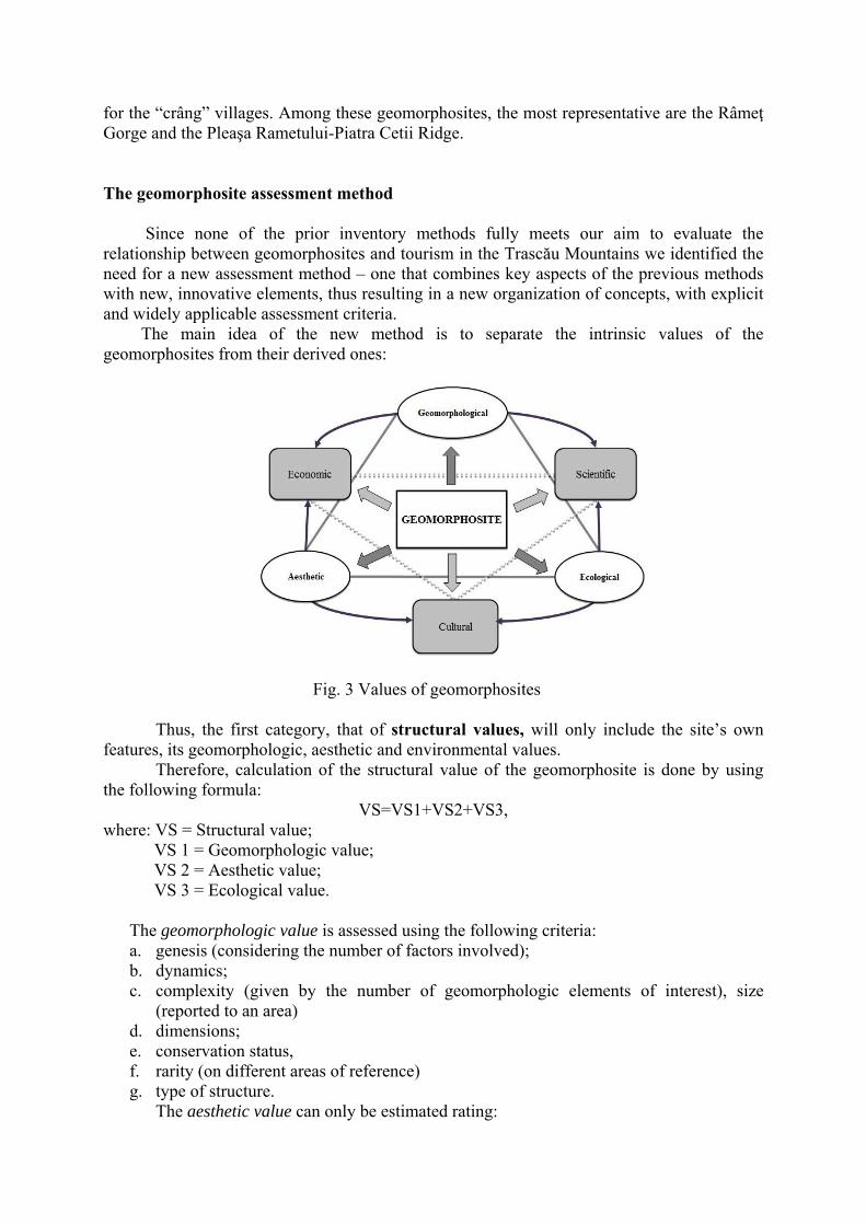
The geomorphosite assessment method
Since none of the prior inventory methods fully meets our aim to evaluate the
relationship between geomorphosites and tourism in the Trascău Mountains we identified the need for a new assessment method – one that combines key aspects of the previous methods with new, innovative elements, thus resulting in a new organization of concepts, with explicit and widely applicable assessment criteria.
The main idea of the new method is to separate the intrinsic values of the geomorphosites from their derived ones:
Fig. 3 Values of geomorphosites
Thus, the first category, that of structural values, will only include the site’s own features, its geomorphologic, aesthetic and environmental values.
Therefore, calculation of the structural value of the geomorphosite is done by using the following formula:
VS=VS1+VS2+VS3, where: VS = Structural value;
VS 1 = Geomorphologic value; VS 2 = Aesthetic value; VS 3 = Ecological value.
The geomorphologic value is assessed using the following criteria: a. genesis (considering the number of factors involved); b. dynamics; c. complexity (given by the number of geomorphologic elements of interest), size
(reported to an area) d. dimensions; e. conservation status, f. rarity (on different areas of reference) g. type of structure.
The aesthetic value can only be estimated rating:
a. physiognomy (the assessment of the form’s appearance); b. color; c. display (the possibility for observation); d. elevation or configuration (criterion with a differential use for evaluating surface
landforms or underground forms, caves, pit caves or salt mines, for which layout is just as relevant as dimensions). The ecological value is represented by:
a. flora b. fauna c. the current state and form of protection.
Each of these values is also the sum of index values assigned to their own characteristics. Thus, the geomorphologic value, VS 1, for example, consists of:
The second category encompasses the so-called functional values, attributes given according to human perception or human exploitation, whether through research, (offering a scientific and educational value to the site) or through the past exploitation of the site as a building ground, as a place of faith or arts or as a tourist resource.
The functional value of each geosite is calculated using the following formula:
VF=VF1+VF2+VF3,
where: VF = Functional value; VF 1 = Cultural value; VF 2 = Scientific value; VF 3 = Economic (touristic) value. The cultural value sums up:
a. the historical quality (relevance of remains on different levels); b. the archaeological importance (age of historical sites within perimeter); c. the religious significance (the presence of monasteries or churches); d. the association of the site with different symbols, e. the artistic value (number of representations in literature, paintings, graphics and
photography); f. the frequency of associated cultural events; g. architectural features.
The scientific value is quantified using the following criteria: a. scientific significance (quantifying the importance of references); b. scientific resources (estimation of the survey potential); c. formative significance (wideness of target group); d. usefulness as a model (relevance); e. representativeness (on different levels); f. paleontological value (abundance and conservation of paleontological remains).
In quantifying the scientific value, the separation of the criteria strictly related to this value from the ones evaluating the geomorphologic value, avoiding therefore duplication, is very important.
For the estimation of the economic value, some indicators of tourism potential and exploitation are taken into account:
a. number of possible recreational activities;
b. the site’s touristic potential on various levels; c. accessibility (type of transport and distance); d. type of accommodation infrastructure; e. present arrangement and services; f. the distance from the geosite; g. the distance from modern centers with complex services (in kms); h. socio-economic features of the region (considering the size of urban centers located
within 25 km); i. status of current touristic exploitation (complexity and seasonality); j. level of site promotion; k. frequency of sport competitions.
Similar to the previous group of values, each of the mentioned values represents the sum of the more specific criteria, for instance, the cultural value has the following formula:
Another aspect to be taken into account is that some factors act restrictively on the
value and potential of the geosite. They will be assessed separately, since their value is substracted in the final formula. Risks and vulnerability, the presence of factors that could decrease the attractiveness of the site, unfavorable economic activities or negatively perceived infrastructures are all restrictive attributes.
Their numerical expression represents the sum of the included parametres:
AR=AR1+AR2+AR3+AR4 where AR = Restrictive attributes;
AR1 = Natural and anthropogenic risks; AR2 = Vulnerability; AR3 = Presence of economic activities that might affect tourism; AR4 = Unsightly elements.
Thus, the global value of a geomorphosite is calculated using the following formula:
VG=VS+VF-AR,
where: VG = Global value of the geomorphosite;
VS = Structural value of the geomorphosite; VF = Functional value of the geomorphosite; AR = Restrictive attributes. Considering the characteristics and criteria mentioned above, each of them having its
own five-point rating scale, we consider that the proposed method provides sufficient possibilities for an accurate assessment of the relationship between geomorphosites and tourism.
The method has been tested in the assessment of geomorphosites in the Trascău Mountains, where 92 such sites have been evaluated (Fig 4.).
Fig. 4. Trascău Mountains. Geomorphosite map.
The inventory card that we propose reflects the criteria used by the assessment
method and is designed for estimating the values of the different variables in the formula (geomorphologic, aesthetic, ecological, cultural, scientific and economic).
The inventory card consists of two parts: one relating to the identification and designation of the geomorphosite and a second, analytical part.
The first one includes basic information about the geomorphosite: the official name and other denominations (if the case); the record indicative, that consists of the letter T, indicative standing for the Trascău
Mountains, and a number, representing the place it occupies in the hierarchy of the region’s geomorphosites;
basic information about the general location within the region and the territorial-administrative units are also mentioned here and other data like coordinates can be added if necessary;
the typology and spatial extension of the geomorphosite (punctual, linear or areal). These features are essential for a brief characterization of the geomorphosite and are also a starting point for further analysis;
the complexity of the geomorphosite: simple, complex and systemic; the generic type of landform represented by the site should also be mentioned (isolated
massifs, gorges, plateaus, caves etc.); the general value, structural and functional values, as well as the restrictive attributes
are indicated in this part, in order to create a first insight on the relevance of the analyzed geomorphosite;
a representative photograph or map of the area must also be attached. The second part covers the criteria used in the evaluation, and it is an opportunity for
the assessor to explain in more detail the points given for different criteria. It consists of three distinct sections, reflecting the three aspects evaluated in the assessment method: structural and functional values and restrictive attributes.
Table 1 Inventory card for geomorphosites
STRUCTURAL VALUE
Value Pt Justification
Geo
mor
phol
ogic
4.75
- its genesis involves at least two morphogenetic factors: tectonics, lithology and epigenetic processes (0.5 pt.) - slow dynamics (0.5 pt.) - in terms of complexity, there are more than five elements of interest: impressive slopes (Peretele Uriaş, Suurimea etc.), ridges (Creasta Sură, Creasta Colţului Crăpat etc), arches, pillars, 22 caves, among which four of them were identified as singular geomorphosites: Binder, Cetăţeaua Mare, Cetăţeaua Mică and Ungurească (1 pt.) - it is among the most relevant gorges on a regional level (0.75 pt.) - only slightly affected geomorphosite (0.75 pt.) - unique site in the region, especially due to the number of attractive elements and their association (0.5 pt.) - particular structure, visible in the structural surface in the upper part of the left slope (0.75 pt.)
Aes
thet
ic
3.25 - particular physiognomy due to the association of the above elements (0.75 pt.) - 300-500m elevation (0.75 pt.) - chromatic puzzle, constituted by the variety of colors (0.75 pt.) - panoramic perceived element (1pt pt.)
Ecol
ogic
2.75
- presence of relict or endemic plants: Allium obliquum, Sorbus dacica, Ferula sadleriana, Ephedra dystachia (1 pt.) - regionally unique biotope with rich fauna (0.75 pt.) - fully protected area, Turzii Gorge Reserve, one of the oldest nature reserves in the country, established in 1938 (1 pt.)
INVENTORY CARD FOR GEOMORPHOSITES Name TURZII GORGE
Indicative T1 Location Hăşdatelor Valley, central
part of Petreşti Range UAT Cheia, com. Mihai
Viteazu, Petreştii de Jos, com. Petreştii de Jos,
Sănduleşti Typology Systemic geomorphosite
Gorges Extension Linear
General value 25 Structural value 10.75 Functional value 15.5
Restrictive attributes
1.25
FUNCTIONAL VALUE
Type Pt Justification C
ultu
ral
3.25
- regionally defining artefacts, civil housing site in caves: Ungurească and Peştera lui Binder (0.75 pt.) - prehistoric sites in the Călăştur Cave (0.75 pt.) - symbolic relevance discretely associated with the site, derived from the legend of Balica and his hideouts, Cetăţeaua Mare and Cetăţeaua Mică caves (0.75 pt.) -more than 50 representations in art, mostly photographs (1 pt.)
Scie
ntifi
c
4.75
- major scientific significance, at least one scientific theory related to the genesis and evolution of the landform (1 pt.); - recognised survey potential – numerous bibliographic citations in relevant papers about Trascău and Apuseni Mountains (1 pt.); - wide target group (1 pt.) - national representativeness (0.75 pt.) - model of maximum relevance (0.75 pt.)
Econ
omic
7.50
- 4-5 types of recreational touristic activities possible in the perimeter: climbing, hiking, paragliding, geotourism, speleotourism (0.75 pt.) - regional landmark (0.75 pt.) - vehicle access up to 500 m from the site (0.75 pt.) - modest lodgings in the perimeter or modern one within 5 km –Cheile Turzii Cabin, Laura B&B (0.75 pt.) - equipment and modern facilities and services outside the perimeter (0.75 pt.) - Turda, centre of over 25000 inhabitants, is nearby (0.5), within 10 km (0.75 pt.) - complex seasonal exploitation during summer time (0.75 pt.) - complex national promotion, as one of the main touristic attractions of the Apuseni Mountains (0.75 pt.) - hosting a major sport competition - ATTA Climbing Competition (1 pt.)
RESTRICTIVE ATTRIBUTES
Score Justification 1.25
- the presence of factors that could affect the site: farming and grazing (0.5 pt.) - controllable risks, flooding and rock fall (0.5 pt.) - the site is vulnerable, but cannot be strongly affected (0.25 pt.)
MORPHOLOGICALLY CONDITIONED TYPES AND FORMS OF TOURISM The tourist potential stored in the Trascău Mountains determined the emergence and
development of all four types of tourism: recreational, curative, cultural and complex, but with large differences among them. The region’s most diverse and consistent resources are for leisure and recreational tourism, which has thus become the most developed type of tourism in the analyzed area. Curative tourism can only be practiced as “mountain cold cure” with outdoor exercise, and only in certain areas. Cultural tourism is based on various resources located in the area, starting from historic, religious and cultural attractions, up to the great number of reservations. Complex tourism includes rural and transit tourism.
Recreational tourism
The most representative forms of recreational tourism in the Trascău Mountains are
climbing and hiking, generating the most substantial tourist flows. For climbing, this is due to the exceptional potential of the area, with its impressive limestone vertical scarps. Hiking is a very popular recreational form, too, having the widest target group among the tourism forms in the region. Some forms with a smaller target group, or less representative, such as canyoning, paragliding, airplane overflights, speleotourism, cycling, hunting and sport fishing can also included here.
Climbing. The relief of the Trascău Mountains, characterized by the presence of isolated massifs and the great number of gorges, put these mountains on the Romanian climbing map. Each category of slopes (marginal scarps from ridges, side scarps on isolated massifs, scarps from gorges) has a great number of climbing routes. There are today over 1000 routes in the Trascău Mountains, where all kinds of climbing find suitable conditions: classic rock climbing, sport climbing, endurance climbing (on longer trails, over 3-4 pitches) or bouldering (a form of climbing practiced without rope, on more difficult routes, but located at lower heights).
The most representative climbing areas in the Trascău Mountains are Turzii Gorge (18 climbing sectors with a total of 314 routes), Colţii Trascăului (193 routes), Turenilor Gorge (116 tracks), Aiud Gorge (102 routes), Pietrele Ampoiţei (90 routes) and Mănăstirii Gorge (74 routes).
Most climbing routes in the Trascău Mountains reach up to 7- and 8- difficulty degree, corresponding to a medium-advanced training. Around 40, however, reach up to 9+/10-, with 10+ corresponding to the maximum level of difficulty in Romania.
Ice climbing, a novel form of climbing, is also practiced in the area, even if it has not a similar tradition to that of other massifs in the Apuseni Mountains, such as Muntele Mare or Vlădeasa. But in the recent years, the vertical ice slope formed in the Vânătara sinkhole has attracted passionate tourists. Favorable conditions can also be found at the Şipote Waterfall.
Hiking, one of the most free forms of tourism, can be practiced all throughout the massif, on longer or shorter trails, more or less difficult. The great diversity in length and degree of difficulty among trails turns hiking into the most accessible form of tourism for the Trascău Mountains. Tourists of all age groups, of any training and shape, can identify a trail accessible to them. They can choose short walks along trails with no slope or obstacles, having a low degree of difficulty, or to approach a long trail of great difficulty, that might require skills or equipment.
Cycling. There are no special cycling routes, with the existing infrastructure, county roads or specific sectors of hiking trails being used instead. Some popular routes for cycling are: Colţeşti- Râmeţ Monastery, the ones along county roads on the Galda or Râmeţ valleys,
and others that lead to different attraction points like Ighiu Lake, Cetii Gorges etc. Speleotourism can be practiced in one way or another in most of the important caves
in the Trascău Mountains, especially the ones also found in the geomorphosites list. Generally, mass speleotourism faces the obstacle of lack of arrangements. A good example is Huda lui Papara Cave, whose flooded main room restricts entrance to those having the proper training, experience, and of course, equipment. Among the caves in the above mentioned list there are several important ones, such as:
Dâmbău Pit Cave, Gemenele Pit Cave, Faţa Pistrii Pit Cave, that are being exploited through an extreme speleological tourism,
and of course Huda lui Papară and Peştera cu Apă caves, in which speleotourism appears in more complex ways, associated to geotourism.
Canyonig is only present in the Trascău Mountains in the Cetii Gorge. This gorge is one of the shortest in the region (100m), and is characterized by a succession of waterfalls and large marmites that make it an ideal area for canyoning. The presence of the Trascău Mountains among the five locations in Romania where canyoning is practiced gives them a national significance.
Paragliding is a form of tourism that finds favorable conditions in the studied region due to major differences in height level. One can identify four major practice areas: the Petreşti Ridge, Colţii Trascăului (Rimetea), Bogza Hill and Data Massif. Rimetea is now known internationally, due to its multiple departure points and the wide landing areas.
Airplane overflight is a form of entertainment recently introduced as a result of private initiatives. It allows tourists to get panoramic views of the landscape, with a large perspective upon the northern and central Trascău, focusing on the Piatra Secuiului, Trascău Depression and Turzii Gorge.
Hunting and fishing are indirectly influenced by relief through the biotopes it generates. Hunting is intensely practiced near Sloboda Chalet, in Bedeleu-Tarcău Area, Ighiu surroundings and Dâmbău, while fishing is practiced on the Stremţ, Galda, Arieş and Feneş rivers.
Curative tourism
It is practiced mainly in connection with the development of tourism infrastructure in
Sălciua, Ighiu and the Trascău Depression, where the microclimate is favorable. Still, due to the lack of mineral or thermal waters, or of some caves with a favorable therapeutic topoclimate (Huda lui Papară does not fall within this category due to its powerful ventilation), curative tourism is still underrepresented the Trascău Mountains, and does not have broad prospects for development.
Cultural tourism
Cultural tourism has many facets, in close correlation with its attractive resources.
Note that in all these cases, the relief is only the scenic background or material support of related infrastructures.
Religious tourism/pilgrimages are indirectly related to the relief, due to the monasteries’ locations in areas like gorges (Râmeţ), closed depressions (Rimetea) or next to steep slopes (Sub Piatră). It has a predominantly occasional nature, with a maximum flow during dedications of the above mentioned monasteries.
Ethno-cultural tourism is generated by folklore events, customs and tradition held in numerous locations within or just outside the area. Rimetea, Sălciua, Bucerdea Vinoasă, Craiva are just some of the representative areas in this regard.
Ecotourism or tourism in protected areas has a wide spatial extent due to the numerous natural reserves. As a form of tourism mainly based on fauna and flora, it is best represented in two locations: The Daffodil Reserve of Negrileasa and Laricetul de la Vidolm. The Turzii Gorges, Întregalde Gorges, Colţii Trascăului must also be taken into consideration.
Geotourism The original meaning of the term involves sightseeing in natural environments, in order to better know and understand geomorphic processes. In essence, geomorphosites, due to their scientific value, are the main resource of this type of tourism. The geotourism value of the Trascău Mountains is constituted by the many geomorphosites, relevant not only for the Apuseni Mountains, but also for the Romanian relief.
A first attempt of a geotourist trail was “The limestone road”. As a first initiative, this route seems quite articulate, highlighting the 15 nature reserves, but, in the end, it remains too general and aimed at very different things. Thus, the development of specific thematic roads, such as the gorges road, scarp road, ophiolite road, lookout points road seems to be much closer to the international trends. Also, of great importance for geotourism would be the establishment of a Geopark: The Isolated Massifs Geopark. This proposal is supported by the fact that the Trascău Mountains are the only territory in Romania for which eight morphogenetic theories were put forward. It would include the isolated massifs between Galda and Ampoi, and the gorges and caves in the Galda, Ampoiţei, Feneşului basins, and the pit caves from Dâmbău.
Complex (mixt) tourism
It is the second most representative type of tourism in the Trascău Mountains, due to its most important form, rural tourism. Many settlements in the area have an authentic rural ambience in which guests can discover the village with all its customs and traditions, with crafts, folklore and gastronomy.
The Trascău Depression, with its centre Rimetea, is the most important location for this type of tourism, due to the number of boarding houses, the intensity of touristic flows and the international origin of tourists (mainly Hungary). Plus, the Cricău-Bucerdea Vinoasă area, where, paradoxically, there are no boarding houses yet, hosts a series of events meant to encourage tourism: Cununa Grâului in Bucerdea Vinoasă, Festivalul Cetăţilor Dacice in Cricău, a festival opened by the Dacian Wine celebration, with the only purpose of promoting the rural and winery tourism in the area.
MORPHO-TOURISTIC RISKS
The “morpho-touristic risk” notion is a complex one, involving both objective risks, of geomorphic nature, and the vulnerability of tourist attractions, geomorphosites especially, as fundamental attraction points for the region. The category also include the tourist vulnerability to natural hazards and subjective risks that interfere in different forms of tourism. Natural hazards
For the Trascău Mountains, one can identify four main categories of risks spread
across the territory according to lithological and morphological features: processes involving
tumbles and falls off (dislocations, subsidence, debris), landslides, torrentiality and avalanches.
Dislocations, subsidence, debris Dislocations can be noted on slopes of most gorges (Turzii, Râmeţului, Galdiţei etc), on the scarps of the Pleaşa Rameţului-Piatra Cetii Ridge and Bedeleu. The collapse of a major portion of rock is a major risk in the Mănăstirii Gorge.
Debris, organized according to morphology and inclination of the slope, are mostly located in Colţii Trascăului, Bedeleu, Piatra Grohotişului, Dosul Blidarului, Creasta, Corabia and Dâmbău, and in most gorges (Turzii, Întregalde, Tureni etc.).
Landslides Contemporary landslides affect reduced areas in the Trascău Mountains, located in the southern part of the massif, in the Ampoi, Bucerdea and Craiva basins. The landslides are generally small and at the surface, except in the upper Craiva basin, where they forced the relocation of the Craiva village.
Torrentiality is still not widely developed in the area, only in the Arieş, Rameţ and Ţelna basins. Ravines are more frequent, being present in the sandstone and clay area of the Ampoi, Ţelna and Craivii basins.
Avalanches Although no major events usually occur, there can be modest avalanches in gorges and on the slopes of Bedeleu and Colţii Trascăului, where snow accumulation is more pronounced. As a mitigation measure, the trails present in these areas are not recommended in winter, some of them, like the upper trails in the Turzii and Râmeţ Gorges, and the main trail to Piatra Secuiului, being closed in winter time, in case of heavy snow.
Tourist vulnerability to subjective risks Subjective risks appear more often in the literature, in recent years, because most of
the accidents affecting tourists are caused due to their personal behavior, rather than natural hazards. But a precise estimation of these parameters is quite impossible, due the specificities of such risks to each individual.
Moreover, tourist vulnerability and risks associated to different forms of tourism are different. Places suitable for climbing, speleotourism or canyoning are more fragile environments, thus, more exposed to geomorphic risks. Hiking trails can also pass through such areas; arranging these trails would substantially reduce such subjective risks, and make them more suitable for a broader category of tourists.
Geomorphosite vulnerability
Another issue often debated in the study of geomorphosites is related to their
vulnerability. Several authors point out that geosites in general may be highly vulnerable, as they may be strongly affected, or even destroyed by anthropogenic activities (from vandalism acts on small geosites up to the large-scale industrial activities). Anthropogenic risks
Anthropogenic risks are added to the natural ones, and both affect, alter or even
destroy geosites. Industrial exploitation The large spatial extent of limestone and their excessive
fragmentation has facilitated the development of several locations of industrial exploitation of carbonate rocks. Such quarries functioned or are still functioning in Tureni, Sănduleşti, Poiana Aiudului, Poiana Galdei and Lunca Ampoiţei. One can note that most of them are located in the immediate vicinity of some reference geomorphosites: Turzii, Turenilor,
Aiudului gorges etc. Their proximity led sometimes to a brutal interference upon these geosites – as it was the case for Ampoiţei or Turenilor gorges. Among all anthropogenic risks, industrial exploitation is by far the most important, with the most pronounced effects on the landscape and its touristic potential.
Risks derived from pastoral land use Agriculture and its specific land use (mainly for grazing) is widely spread in the Trascău Mountains and has represented for centuries the main occupation of the inhabitants. Nowadays, grazing is practiced even in the perimeter of some reserves such as Colţii Trascaului, Turzii and Râmeţului gorges, Pleaşa Râmeţului-Piatra Cetii, where it becomes a major risk factor for plant associations, endemic and relict plants etc.
Infrastructure built within the perimeter of geomorphosites A first category of such infrastructure, of a clear negative impact upon the landscape and its touristic potential are the old, abandoned and damaged cattle farms (in the Vânătara area, and the ones in Pleaşa Rametului). Recent constructions can also have a negative impact upon geomorphosites. Construction in the mountain area, in general, and construction in the perimeter of geomorphosites in particular must seek the harmonious integration in the landscape. Many of the buildings, however, and secondary residences especially, disregard this principle, using materials often not in tone with the environment, local colors or tones. The impact of tourism on the relief
Travelers involved in various forms of unorganized tourism can trace paths that affect the integrity or the structure of minor morphology elements. Such paths are created by climbers, but especially by paragliding practitioners, that try to reach the departure points by vehicle, due to the weight of the equipment and, of course, tourists traveling by off-road vehicles and ATVs.
Another negative way in which tourists are leaving their marks is by writing and drawing on different geomorphosites: slopes of gorges, scarps of isolated massifs and caves’ walls. One can “admire” such marks in Turzii, Turenilor, Rameţului or Galdei Gorges.
The aesthetic degradation of abandoned tourist infrastructures is another
important issue. One can note constructions that were begun and never completed, abandoned, which are deeply adversely affecting the landscape – such as the constructions in the Turenilor Gorge and the abandoned old campings and cabins from Sloboda, Turzii Gorge, Întregalde Gorge.
The most widespread form of tourist pollution in the region is waste (garbage)
resulting from weekend and public holiday tourist activities. Although in some areas, such as Râmeţ Gorges, local authorities have mounted storage boxes for this type of waste, the lack of an organized and regular collecting service diminish their usefulness. Still related to weekend tourism is the pollution of water courses, usually because some tourists still wash their cars on river banks, spilling various detergents or mineral residues.
Mitigation of morpho-touristic risks
From the rich set of measures to be taken, one can identify some main directions:
- detailed information should be made available to tourists about the risks they run in each visited area or geomorphosite, using information tables, guides and brochures;
- generalization of organized tourism, coordinated by competent authorized monitors (as several forms of tourism require an adequate expertise – for instance, canyoning or
speleotourism in Huda lui Papară or in pit caves); - restriction of tourist access in areas of obvious morphological risks: steep slopes with
debris, subsidence or collapses risks, caves that can be flooded by unexpected rain (for instance, Huda lui Papară);
- technical assistance in sectors of increased vulnerability; - adequate logistics for quick response in case of emergencies.
THE ARRANGEMENT OF TOURISTIC ATTRACTIONS
The development and diversity of facilities is strictly correlated to the degree of isolation
and accessibility, structure and functions (touristic and non touristic) of the different attraction points. Depending on this typology, we distinguish: - arrangements for touristic access; - arrangements for the enhancement of some touristic resources (caves, gorges, scarps,
lookout points); - building of accommodation infrastructures.
CONCLUSIONS
The link between relief and tourism can be identified at three main levels: relief as a primary or secondary tourist resource, relief as scenery background and relief as physical support for logistics and activities. Among the defining features of relief, we can identify: - the unique character of some landforms, resulting either by the modeling of a single
specific form or by the destruction or loss of all other similar forms; - novelty in terms of physiognomy, positioning and functional attributes; - structural complexity of elements; - typological diversity that proportionally influences the attractiveness of an area; - dimensional relations (oversized items with a greater force of attraction); - vertical display: the more relevant in space, the more relevant for tourism.
On the basis of their different degree of attractiveness, we noticed the individualization of some forms, with an outshining effect in the area, on other similar forms that will end up by not being included in the touristic offer, no matter their actual importance.
This attractive outshine phenomenon takes two forms: - an objective outshine - due to hypsometric differences, vertical display, original
appearance of the landscape, variety of detail morphology, associated to the tendency of relief types to outshine other types;
- subjective outshine, manifested either at the individual tourist level, induced by his/her own recreational, curative or cultural options, or at the whole touristic phenomenon level, due to the variety of offers from tourism promoters, different accessibility and different touristic endowments.
Relief stands as a touristic resource, due to forms with touristic attractiveness: - marginal scarps of ridges, side scarps of isolated massifs, scarps from gorges having a
positive impact on the landscape; - ridges, such as Colţii Trascăului and Pleaşa Rameţului; - gorges, the most important morphological resource for the Trascău Mountain, because
of their great number, wide spread across the region, different morphology and physiognomy, as well as the large number of secondary elements of touristic interest they encompass: towers, caves, waterfalls, marmites, natural bridges etc.;
- defiles, clearly outshined by gorges, only the larger ones standing out as primary touristic resources – such as Arieş and Ampoi defiles;
- swallets as highly novel elements, of which Vânătara is the most important; - caves and pit caves, that besides having a clear contribute to landscape, can also be
subject to touristic exploitation or even extreme speleotouristic activities; - isolated massifs, one of the brands for the Trascău Mountains, distinguishable through
their peculiar genesis, sudden emergence into the landscape, distinct features, variety, physiognomy and color, opportunities for hiking and climbing;
- waterfalls, as morpho-hydrographical elements (although there are only two relevant examples in the region: Văii Poienii and Şipote waterfalls).
The same element of relief can be differently perceived, thus assuming different touristic roles. For instance, landforms constitute just the scenery background for other, better individualized touristic resources (hydrological elements, fauna, flora, historic, religious, ethnographic, eno-gastronomic etc.) when they are located in the background, at a distance, or if they are less spectacular and do not have “their distinct personality”.
Relief also meets the function of support for touristic infrastructure, access roads and various tourist facilities. The dominant accommodation infrastructure is the boarding house, concentrated in 3 main areas: Trascău Depression-Aiud Valley, Ighiu-Ampoiţa and the Middle Arieş area. Cabins are also present in the area, two being more important: Rameţ and Buru.
We selected 92 geomorphosites among the interesting landforms in the Trascău
Mountain, belonging to the following groups: isolated massifs, gorges, speleological geomorphosites, swallets, karst plateaus, ridges and peaks.
Lithological and structural diversity triggered the diversity of geomorphosites in terms of their spatial extension. Thus, we can distinguish point geomorphosites (small caves, sinkholes, small isolated massifs), linear geomorphosites (gorges and longer caves) and areal geomorphosites (peaks, ridges, plateaus, the Ighiu Lake).
Taking into account the level of complexity, we differentiated among simple geomorphosite (with no constituent elements), complex ones (with more such elements) and systemic geomorphosites (greater geomorphosites containing smaller ones).
Geomorphosites can also have a hydrographic or hydrogeological, landscape, botanical, faunistic, historic, religious and/or ethno-cultural importance.
For the assessment of these geomorphosites, we have developed a new method that
introduces several new criteria and has a new structure, a method based on the separation among structural and functional values.
In order to facilitate the inventory of geomorphosites, we have also proposed a new inventory card.
Among the tourism forms in the area, climbing is the most representative, Trascău
Mountains having over 1000 climbing routes, most of them of medium difficulty, with a remarkable density in Romania.
Other tourism forms present in the area are rural tourism, hiking, speleotourism, canyoning (one of the few areas in Romania where canyoning is present), paragliding, overflying, and other forms of the recreational, curative or cultural tourism.
One form for which the Trascău Mountains have relevant resources is geotourism, that could be developed through thematic routes linking the 92 geomorphosites. The initial model could be that of the Limestone Road, that could serve as an example for designing more specific ones (thematic routes of gorges, ophiolites or lookout points, for example).
Morpho-touristic risks have been analyzed as objective phenomena, but also as subjective ones, differentiated among individuals.
References to the vulnerability of geomorphosites to natural, morphological or anthropical risks have also been made.
SELECTIVE REFERENCES
1. Alcantara-Ayala, Irasema (2009) Geomorphosite Management in Areas Sensitive to Natural Hazards In Reynard, E., Coratza, P., Regolini-Bissig G., (2009) Geomorphosites, Verlag Dr. Friedrich Pfeil, Munchen, pag 163-173
2. Avanzini M, Carton A, Sepp R, Tomasoni R (2002) First Census of Geosites in the Province of Trento, Procedings Geomorphological Sites: research, assessment and improvement, Modena
3. Bertacchini, Milena, Bettelli, G., Bonazzi, U., Capedri, S., Capitani, M., Castaldini, D., Conti, S., Corradini, D., Fioroni, C., Fontana, D., Fregni, P., Gasperi, G., Giusti, C., Lugli, S., Marchetti, M., Panini, F., Pellegrini, M., Piacente, S., Rossi, A., Soldati, M., Tosatti, G., (1996) I beni geologici della Provincia di Modena. Artioli Editore, Modena
4. Bleahu, M., Dimian, M. (1967), Studii stratigrafice şi tectonice în regiunea Feneş-Ighiel-Intregalde (Munţii Metaliferi), D.S. Inst. Geol. LIII (1965-1966), 1.
5. Brancucci, G., Carton A., Pavia G., (1999) Scheda inventario geositi, Geoitalia, n 4. Novembre 1999
6. Brancucci, G., (2003) Geositi e Dintorni, PRIN Cofin-Miur 2001/2003 7. Bruschi, V. M., Cendrero A., (2005) Geosite Evaluation: Can We Measure Intangible Values? In Il
Quaternario, Italian Journal of Quaternary Sciences / Geomorphological Sites and Geodiversity, Vol 18 (1) 2005, Volume Speciale, pag 293-306
8. Bruschi, V.M., Cendrero, A., Direct and Parametric Methods for the Assessment of Geosites and Geomorphosites In Reynard, E., Coratza, P., Regolini-Bissig G., (2009) Geomorphosites, Verlag Dr. Friedrich Pfeil, Munchen, pag 73-88
9. Burlando, P. (2001) Geositi e carte della natura. In Atti Conv. “Geositi, tra tutela e valorizzazione della natura” Carrara, Ottobre, 2001, pag 31-38
10. Carton, A., A. Cavallin, F. Francavilla, F. Mantovani, M. Panizza, G. Pellegrini, C. Tellini (1993) Ricerche ambientali per l’individuazione e la valutazione dei beni geomorfologici – metodi ed esempi – Il Quaternario 7, 1,
11. Castaldini, D., Piacente, S., Ghiddi, E., Vaccari, F. (1996) I beni geomorfologici: esempi di valutazione e di rappresentazione cartografica in un’area collinare della Provincia di Modena, in Mautone, M., (a cura di) „Una giornata di studio in onore di Mario Fondi. Scritti geografici”, vol 1, Napoli
12. Castaldini, D., Valdati, J., Ilieş, Dorina. Camelia. (2005) The Contribution of the Geomorphologic Mapping to the Environmental Tourism in Protected Areas: Examples from the Apennines of Modena (Northern Italy). Revista de geomorfologie, vol 7, 91-106
13. Castaldini, D. (2008), Maps and Multimedia Tool for the Environmental Tourism in Protected Areas of the Modena Apeninnes (Norhern Italy), GeoJurnal of Tourism and Geosites, I, 1, 1, Oradea.
14. Cândea, Melinda, Simion, Tamara (2006), Potenţialul turistic al României, Editura Universitară, bucureşti.
15. Cendrero, A. (1996) Propuesta sobre criterios para la classification y catalogacion del Patrimonio Geologico. In: El patrimonio geologico. Bases para su valoracion, proteccion, conservation y utilizacion, Monografias del Ministero de Obras Publicas, Transportes y Medio Ambiente, Madrid, 29-38
16. Ciangă, N. (1998), Turismul din Carpaţii Orientali. Studiu de Geografie Umană, Editura Presa Universitară Clujeană, Cluj Napoca.
17. Cocean, Gabriela (2009), Cabanele şi refugiile din Munţii Trascău, Geographia Napocensis, III, 2, Cluj Napoca.
18. Cocean, Gabriela (2010), Accommodation Infrastructure in the Trascău Mountains- Tourist Boarding Houses Studia UBB.
19. Cocean, Gabriela (2010), The Tourist Role of Relief as Landscape Background, Romanian Review of Regional Studies, Vol VI, Number 1, Cluj Napoca
20. Cocean, Gabriela (2010), Fenomenul de eclipsare atractivă, Geographia Napocensis, IV, 2, Cluj Napoca
21. Cocean , Gabriela, Anghel, D. (2011), Alpinism şi escaladă în Munţii Trascău Geographia Napocensis, V, 1, Cluj Napoca
22. Cocean, Gabriela, Surdeanu, V. (2011), The Assessment of Geomorphosites of Touristic Interest in the Trascău Mountains, Studia UBB, LVI, 2, Cluj Napoca (in press)
23. Cocean, P. (1984), Potenţialul economic al carstului din Munţii Apuseni, Editura Academiei Republicii Socialiste Romania, Bucureşti.
24. Cocean, P. (1995), Peşterile României. Potenţial turistic, Editura Dacia, Cluj Napoca. 25. Cocean, P., Silvestru, E. (1988), The Role of Magmatism in the Genesis of Isolated Massives
Karst Relief of Trascău-Metaliferi Mountains, Trav, Inst. Speol. ,,E. Racoviţă”, XXVII, Bucureşti. 26. Coratza, Paola. (2003) Siti geomorfologici: ricerca, valutazione e valorizzazione, Esempi in
Emilia-Romagna- Tesi Dottore Ricerca, Universita di Modena e Reggio Emilia, Dipartimento Scienze della Terra
27. Coratza Paola, Giusti, Cecilia (2005) Methodological Proposal for the Assessment of the Scientific Quality of Geomorphosites In Il Quaternario, Italian Journal of Quaternary Sciences / Geomorphological Sites and Geodiversity, Vol 18 (1) 2005, Volume Speciale, pag 307-314
28. De Waele J., Di Gregorio F., Gasmi, N., Melis Maria Teresa, Talbi M.(2005) Geomorphosites of Tazeur Region (South-West Tunisia). In Il Quaternario, Italian Journal of Quaternary Sciences / Geomorphological Sites and Geodiversity, Vol 18 (1) 2005, Volume Speciale, pag 223-232
29. Dinu, Mihaela, Peţan, Ioana (2005), Geografia turismului în România, Editura Universitară, Bucureşti.
30. Ficheux, R. (1940), Les Monts de Trascău; Bull. Assoc. Geogr. Fr., 125, Paris. 31. Ghiraldi L., Coratza Paola, De Biaggi E., Giardino M., Marchetti M., Perotti L. (2009),
Development and Usage of Geosites: New Results from Research and Conservation Activities in the Piemonte Region (Italy), Studia Universitatis Babeş-Bolyai, Geologia, 2009, 54, p 23-26
32. Giusti Cecilia, Gonzalez-Diez A (2000) A Methodological Approach for the Evaluation of Impactc on Sites of Geomorphological Interest (SGI) Using GIS Techniques, in Beek K., J., Malenaar, M., (eds) “International Archives of Photogrammetry and Remote Sensing, Proc XIXth Congress of International Society for Photogrammetry and Remote Sensing” Amsterdam 2000, vol 23, Part suppl 7B, 47-53
33. Grandgirard V., (1995) Methode pour la realization d’un inventaire de geotopes geomophologiques. In UKPIK Cahiers de l’Institut de Geographie de l’Universite de Fribourg 10: 121-137
34. Grandgirard, V. (1999). An inventory of geomorphological geotopes in the canton of Fribourg (Switzerland), Mem. Descr. Carta Geol. d’It., LIV, 273-278.
35. Grigore, M. (1974), Potenţialul natural al turismului, Universitatea Bucureşti. 36. Hoblea, F. (2009) Karstic Geomorphosites: Managing Subterranean Natural – Cultural Heritage
sites In Reynard, E., Coratza, P., Regolini-Bissig G., (editors) (2009) Geomorphosites, Verlag Dr. Friedrich Pfeil, Munchen, pag 189-200
37. Hose, T.A. (1996). Geotourism, or can tourists become casual rock hounds?, in: Bennett, M.R. (ed.) Geology on your doorstep : the role of urban geology in Earth Heritage Conservation, London, Geological Society, 207-228.
38. Ianovici, V., Borcoş, M., Bleahu, M., Patrulius, D., Lupu, M., Dumitrescu, R., Savu, H. (1976), Geologia Munţilor Apuseni, Editura Academiei Republicii Socialiste Romania, Bucureşti.
39. Ielenicz, M. (2009) Geotope, Geosite, Geomophosite The Annals of Valahia University of Târgovişte, Geographical Series, Tome 9 / 2009
40. Ilieş, Dorina Camelia, Josan, N. (2007), Preliminary Contribution to the Investigation of the Geosites from Apuseni Mountains (Romania), Revista de Geomorfologie, 9, Bucureşti.
41. Ilieş, Dorina Camelia, Josan, N. (2008), Geosites-Geomorphosites and Relief, GeoJurnal of Tourism and Geosites, II, 3, 1, Oradea.
42. Ilieş, Dorina Camelia, Josan, N. (2009), Geosituri şi geopeisaje, Editura Universitaţii din Oradea, Oradea.
43. Joyce, E.B. (2007) Geotourism, Geosites and Geoparks: working together in Australia, The Australian Geologist, September 2007, pp 26-29.
44. Martini G. (2000) Patrimonio geologico y geoturismo. In Barettino, D., Wimbledon W.A.P. Gallego E (eds) Patrimonio geologico: Conservation y gestion, 161-170
45. Martonne, Emm. de (1922), Resultats des excurions geographiques, Lucr. Inst. Geogr. Cluj, 1. 46. Măhăra, Gh., Popescu-Argeşel, I. (1993), Munţii Trascău. Ghid turistic, Editura Imprimeriei de
Vest, Oradea. 47. Monbaron, M. (2004). Inventaire des géotopes géomorphologiques du Canton du Jura, Swiss
Geoscience Meeting 2004, Lausanne, Académie Suisse des Sciences Naturelles (SCNAT), 253. 48. Muntele I., Iaţu C., (2006) - Geografia turismului – concepte, metode si forme de manifestare
spaţio-temporală, ed. a II-a revăzută si adaugită, Ed. Sedcom Libris, Iaşi 49. Nicolae, I. (1985), Ophiolites of the Trascău Mountains (South Apuseni Mountains), An. Inst.
Geol., Geof., 65, Bucureşti. 50. Panizza M., Piacente, S. (1993) Geomorphological Assetss Evaluation. In Zeitschr fur
Geomorphologie, N, F, Bd 87, 13-18 51. Panizza, M., (2001) Geomorphosites: Concepts, Methods and Example of Geomorphological
Survey – Chinese Science Bulletin, 46, Suppl Bd 4-6 52. Panizza M., (2003) I geomorfositi in un paesaggio culturale integrato In Piacente, S., Poli G.
(2003) La Memoria della Terra, la Terra della Memoria, L’Inchiostro Blue, Bologna, pag 23-27 53. Panizza M (2005) Rischio geomorfologico e turismo. In Panizza M (ed) Manuale di
geomorfologia applicata, cap 12/ Milano, Franco Angeli 302-316 54. Panizza, M., Piacente, Sandra (2008), Geomorphosites and Geoturism, Rev. Geogr. Acad., 2, 1. 55. Pereira P., Pereira, D., Caetano Alves M. I. (2007) Geomorphosites Assessment in Montesinho
Natural Park (Portugal) Geographica Helvetica 62, 3, 159-168 56. Piacente Sandra (2005) Geosites and Geodiversity for a Cultural Approach to Geology, In Il
Quaternario, Italian Journal of Quaternary Sciences / Geomorphological Sites and Geodiversity, Vol 18 (1) 2005, Volume Speciale, pag 11-14
57. Piacente S., M. Bertacchini, P Coratza, M Panizza, M Pellegrini (2003) Geositi e geomorfositi testimoni della geodiversita in Emilia Romagna, In: Piacente, S., Poli, G., (edit) “La Memoria della terra, la terra della Memoria” – Servizio Paesaggio, Parchi e Patrimonio Naturale, Regione Emilia-Romagna Edizioni l’Inchiostro Blu, pag 49-62
58. Piacente, S., Poli, G., (edit) (2003) La Memoria della terra, la terra della Memoria – Servizio Paesaggio, Parchi e Patrimonio Naturale, Regione Emilia-Romagna Edizioni l’Inchiostro Blu
59. Piccini L., Sauro U., Mietto P (2001) Il censimento dei Geositi Ipogei Naturali. In Atti Conv. “Geositi, tra tutela e valorizzazione della natura” Carrara, Ottobre, 2001, pag 27-29
60. Poli G. (edit) (1999) Geositi: testimoni del tempo. Fondamenti per la conservazione del patrimonio geologico – Bologna, Regione Emilia Romagna
61. Pop, M., Barna, Al (1971) Cheile Turzii. Ghid turistic Editura pentru Turism, Bucureşti 62. Popescu-Argeşel, I. (1969), Posibilităţi de valorificare turistică în Munţii Trascăului, Lucr. Col.
Naţ. de Geogr. Turism., Bucureşti. 63. Popescu-Argeşel, I. (1977), Munţii Trascăului. Studiu geomorfologic, Editura Academiei
Republicii Socialiste Romania, Bucureşti. 64. Pralong, J-P., Reynard, E. (2004), Proposal for Assessing the Tourist Value and the Kind of
Exploitation of Geosites in a Tourist and Recreative Context, in „Geomorphological Sites: Assessment and Mapping”, Cagliari, Il Quaternario (proceding).
65. Pralong, J.P. (2005) A Method for Assessing the Tourist Potential and Use of Geomorphological Sites. In Geomorphologie. Relief, processus, environnement 3, 189-196
66. Pralong, J.P., Reynard, E., (2005) A Proposal for a Classification of Geomorphological Sites Depending on their Tourist Value. In Il Quaternario, Italian Journal of Quaternary Sciences / Geomorphological Sites and Geodiversity, Vol 18 (1) 2005, Volume Speciale, pag 315-321
67. Rădoane, I., Rădoane, Maria, Ichim, I., Surdeanu, V. (1999), Ravenele. Forme, procese şi evoluţie,
Editura Presa Universitară Clujeană, Cluj Napoca 68. Rădulescu, N. Al. (1966), Asupra geografiei turismului, Revista Geografică, I-II, Bucureşti. 69. Reynard E. (2003) Geomorphologie et tourisme: quelles relations? In Reynard, E., Holzmann
Carole, Guex D., Summermatter N, (2003) Geomorphologie et tourisme- Lausanne, Institut de geographie, Travaux et recherches n. 24, pag 1-9
70. Reynard E., (2004) Geotopes, geo(morpho)sites et paysages geomorphologiques. In Reynard, E., Pralong, J.P., (2004) Paysages geomorphologiques, Lausanne, Institut de Geographie, Travaux et recherches n 27, pag 124-137
71. Reynard E., (2005) Geomorphosites et paysages – Geomorphologie: relief, processus, environnement, 3, 181-188
72. Reynard E. (2009) Geomorphosites: Definitions and Characteristics. In Reynard, E., Coratza, P., Regolini-Bissig G., (editors) (2009) Geomorphosites, Verlag Dr. Friedrich Pfeil, Munchen, pg 9-20
73. Reynard, E., (2009) The Assessment of Geomorphosites In Reynard, E., Coratza, P., Regolini-Bissig G., (editors) (2009) Geomorphosites, Verlag Dr. Friedrich Pfeil, Munchen, pag 63-71
74. Reynard, E., Fontana, G., Kozlik, L., Scapozza C., (2007) A Method for Assessing Scientific and Additional Values of Geomorphosites – Geographica Helvetica, 62, 148-158
75. Reynard, E., Holzmann Carole, Guex D., Summermatter N, (2003) Geomorphologie et tourisme- Lausanne, Institut de geographie, Travaux et recherches n. 24
76. Reynard E., Panizza M., (2005) Geomorphosites: Definition, Assessment and Mapping. An Introduction - Geomorphologie.Relief, processus, environment 3, 177-180
77. Savu, Al., Haidu, I. (1984), Asupra genezei şi evoluţiei klippelor de calcar din Munţii Trascăului, Studia UBB, XXIX, Cluj Napoca.
78. Serrano E., Gonzalez Trueba J., J., (2005) Assessment of Geomorphosites in Natural Protected Areas: the Picos de Europa National Park (Spain) - Geomorphologie.Relief, processus, environment 3/2005, 197-208.
79. Surdeanu, V. (1998), Geografia terenurilor degradate, Editura Presa Universitară Clujeană, Cluj Napoca
80. Surdeanu, V., Stoffel, M., Pop, O. (2010), Dendrogeomorphologie et dendroclimatologie-methodes et reconstitutution des milieux geomorphologiques des regions montagneuses, Editura Presa Universitară Clujeană, Cluj Napoca
81. Swizewski, C., Oancea, D. (1977), Geografia turismului, Partea I-a, Univ. Al. I. Cuza, Iaşi. 82. Wimbledon W A P, Benton, M., J., Bevins, R., E., Bridgland, D., R., Cleal, C., J., Cooper R., G.,
May V., J., (1995) The Development of a Methodology for the Selection of British Geological Sites for Conservation Part 1 / Modern Geology 159-202