I " ~I= O"'EI= ,r ' tr\} I FOR THE PROPOSED Prepared For: PHILIPPINE INT'L AIR TERMINAlS CO., INC. A. PASC U AL ENVIRONMENTAL CONSULTANCY SERVICES 41 North Diversion Road, Kalookan City ,Philippines and KONSULTA PHILIPPINES, INC. Rm. 2403 Cityland 10, Ayala Avenue, Makati Cty I May 1998
Transcript
I
"
~I=O"'E I=,r '
tr\}
I
FOR THE PROPOSED
Prepared For:PHILIPPINE INT'L AIR TERMINAlS CO., INC.
A. PASC U ALENVIRONMENTAL CONSULTANCY SERVICES
41 North Diversion Road, Kalookan City ,Philippines
ProponentA. 2. Stage of Project PreparationA 3. Extent of the ETA StudyA. 4. Brief Outline of the Study
B.
7789I
1010
Description of the ProjectB. 1. Type of ProjectB. 2. Need for the ProjectB. 3. LocationB. 4. Size of OperationB. 5. Proposed Schedule For
ImplementationB. 6. Description of the Project
2537
38
4244454647
C. Description of the EnvironmentC. 1. Physical ResourcesC. 2. Ecological ResourcesC. 3. Hmnan and Economic
DevelopmentC. 4. Economic and Commercial
ActivitiesC. 5. Infrastructural FacilitiesC. 6. TransportationC. 7. Land PlanningC. 8. Power Sources and Transmission
49
D. Anticipated Environmental Impacts andMitigation MeasuresD. 1. During Construction StageD. 2. Environmental Impacts After
Construction and DuringCommercial Operation 52
7476
77
E. Quality of Life ValuesE. 1. Socio-economic ValuesE. 2. Public HealthE. 3. Recreational Resources and
DevelopmentE. 4. Archeological and Historical
Treasures 78
I
I798081828291
IF. Impacts Mitigation / Enhancement Plan
F. 1. Air QualityF. 2. Water Quality and QuantityF. 3. Solid Waste ManagementF. 4. Traffic ManagementF. 5. Safety/ ProtectionF. 6. Aesthetic Consideration
92G. Environmental Monitoring Action Plan
95R Emergency Preparedness
I L106108114119120
Public InvolvementL 1. Summary ofScopingI. 2. Overview of Brangay 183L 3. Perception SurveyI. 4. Environment without the ProjectL 5. Environment with the Project
122J. Cost-Benefit Analysis
130132
K. ConclusionK. 1. Over-all Net GainsK. 2. Adverse EffectsK. 3. Provisions for follow-up
Surveillance and Monitoring 135
I
I
I
I
I
I
I ANNEXES
-A. PASCUAL ENVIROMENT ALCONSULTANCY SERVICES
ANNEXl
KONSUL T A PHll..IPPINES, INCORPORATED ANNEX 2
ANNEX 3PROJECT SITEIANNEX 4CONCESSIONS AGREEMENT
I PRELIMINARY ENGINEERING DESIGN ANNEX 5
I ANNEX 6MAP OF P ASA Y CITY
GEOLOGIC MAP OF METRO MANILA ANNEX?
ANNEX 8-AAIR SAMPLE
I ANNEX 8-BWATER SAMPLE
ANNEX8-CDENR AMBIENT QUALITY ANDEMMISSION STANDARDS FOR NOISE
ANNEX 8-DAMBIENT AND NOISE LEVEL CONTOURMAP
ANNEX 9RAINFALL
ANNEX 1 0WIND REGIMES
I ANNEX ll-ACLIMATOLOGICAL NORMALS IN P ASA YCITY
I ANNEX Il-BCLIMATOLOGICAL EXTREMES IN P ASA YCITY
ANNEX 12-AFORECAST OF THE INTERNATIONALFLIGHfS
ANNEX 12-BPOWER TRANSMISSION LINES
I ANNEX 13PROJECTION OF PEAK TRAFFIC
ANNEX 13-ASUMMARY OF AIRCRAFf ACCillENTS
MEMORANDUM OF AGREEMENTBETWEEN ADB AND PIA TCO
ANNEX 14
FIRE CODE OF THE PHILIPPINES ANNEX 15
NAJA IPT 3 FIRE PROTECTION PLAN ANNEX 15-AISAMPLE QUESTIONNAIRE ANNEX 16
I ANNEX 1 7A TfENDANCE SHEETOF April 16, 1998 PUBLIC CONSULTATION
I MEMORANDUM OF AGREEMENT ANNEX 18
LE1TER AGREEMENT ANNEX 19
RELOCA nON PLAN ANNEX 20
IRR AND NET PRESENT VALUE FORMULAE ANNEX 21
CHECK LIST OF ENVIRONMENTALPARAMETERS
ANNEX 22
I
A. INTRODUCTION
A.I. Name of Project and Project Proponent
INAJA International Passenger Terminal 3 (IPT 3)A 1. 1. Project
IPIllLIPPINE INTERNATIONAL AIR TERMINALS CO., INC.Proponent .
( PIA TCO ) with address at Valero Street, Makati City
A. 1. 2. Description: The project consists of the design, construction, and operation of
siteinternational terminal building on aa new
approximately 63 hectares located at the Philippine Air
Force Base at Villamor, Pasay City. The NAJA IPT 3
building will be designed to handle a maximum of thirteen
.
I (13) million passengers annually up to year 2003. The
project will replace the existing NAJA IPT 1
A 1. 3. Other Pertinent Background Information
The growth and projection of international passenger movement are presently
beyond the existing capacity ofNAIA IPT 1. Clark International Airport as well
I
I
Ias Subic International Airport are both too far and inaccessible, thus necessitating
the "fast tracking" of a new international passenger terminal to be situated atI
Villarnor Airbase, and with the capacity to handle at least thirteen (13) million
passengers annually. The project, therefore, is a flagship project.
A. 2. Stage of Project Preparation
The project is now on the final stage of architectural and engineering design
planning.
A 3. Extent of the EIA Study-A 3.1. Scope of the Study
The study encompasses the construction and operational stage ofNAIA IPT 3
A. 3. 2. Magnitude of the Project
The ETA study encompasses the principal environmental concerns associated with
airport projects such as:
a. aircraft noise on institutional/residential areas particularly at night;
increased traffic congestion in the airport approaches;b.
2
c. increased risk from aircraft accidents in populated areas along the
I flight path;
I d. fire hazards;
.
e. ambient air quality;
surface water quality;f.
I g. hydrogeology;
I h. impact on flora and fauna;
social perception1.
emergency preparednessJ.
I A 3. 3. Person or Agency Performing the EM Study
This EIA study has been prepared by A. PASCUAL ENVIRONMENTAL
TheCONSULTANCY SERVICES and KONSUL T A PHn.IPPINES, INC.
assistance of TEEM" INC. was sought in the task of data gathering and analysis.
Please see ANNEXES 1 and 2.
3
A. 4. Brief Outline of the EIA Study
The EIA study investigates and analyzes the principal environmental
concerns which may be present during the construction and operational
stages of the project; and formulates mitigating measures.
I A. 4. 1. During the Construction Stage
I a. Physical Environment
.
1 Water quality and quantity
2. Air quality
3. Fire hazards
4. Generation of solid waste
b. Ecological Environment
1. Impact on Paranaque river
Socioeconomic Environmentc.
1 Impact on employment
2. Impact on City income
4
3. Road traffic congestion
4. Community acceptance of the project
I A. 4. 2. During the Operational Stage
I a. Physical Environment
.
1 Water quality and quantity
2 Air quality
3, Fire hazards
I
4.
Generation of solid waste
Ib. Ecological Environment
1. Impact on Paranaque River
Socioeconomic Environmentc.
1 Impact on employment
I2. Impact on City revenue
3. Road traffic
4 Impact of noise from aircraft movement
5
5. Risk from aircraft accidents
Accredited social scientists from the University of the Philippines conducted the
social survey. Actual measurement of noise at NAJA vicinity was undertaken at
various points covering a 24 hour period. Soil borings were undertaken. Samples
I of TSP in the vicinity were taken and analyzed. Other baseline data on surface
I water quality, hydrogeology, and flora and fauna were taken likewise.
I
I
I
I
I
I
II
6
B. DESCRIPllON OF THE PROJECT
B. 1. Type of Project
IThe proposed NAIA International Passenger Terminal 3 (NAIA IPT 3) is a major
infrastructure project; to be designed, financed, constructed, and operated under a
IBuild -Operate -Transfer (BOT) scheme.
IB. 2. Need for the Project
The existing NAIA International Passenger Terminall (NAIA IPT l) was opened
16 years ago in 1981. By 1990 it had exceeded its design capacity of only 4.3
million annual passengers. NAIA IPT 1 has since been expanded by the
.
I construction of the functional areas within the existing terminal building.
Presently, NAIA IPT 1 has a maximum capacity of7 million passengers annually.
I In 1996, this capacity was reached
-The proposed NAJA IPT 3 will replace the existing NAJA IPT I with the primary
.
objective of finally setting up an international gateway comparable to, if not
better than those of neighboring Asean countries. Additionally the proposed
I7
NAJA IPT 3 which is an essential part of the MIAA Airport Master Plan, aims to
capitalize on the ideal location of the Philippines, and enhance the movement of
increasing international passenger traffic, trade and commerce in Asean and the
Pacific region. The NAJA IPT 3 concept and design development endeavors to
Iprovide a state -of -the art international passenger terminal consistent with the
expectations of global travel in the coming 21 st century.
B. 3. Location
The selected site for IPT 3 is at Villamor Airbase, Pasay City, which was ceded to
Ithe Bases Conversion and Development Authority (BCDA). The site is 1.5 krnInortheast of IPT 1, 5 kIn southwest of Makati BDC, and 8 kIn southwest of
.
Manila. It is located east of Runway 13/31 and north of Runway 06/24 with an
I approximate area of 63 hectares as shown in ANNEX 3.
The approximate point to point distance ofIPT 3 boundary is 430 meters from the
.
I point of intersection of Sales Road and Kalayaan Exit Gate (Pt. A) to Pt. B
parallel to the existing taxiway 13/31 running 1,785 meters to Pt. C. From Pt. C, it
8
is 670 meters diagonally up to the intersection of Andrews Avenue (Pt. D) of
Villamor Airbase and then 1,260 meters going back to Sales Road and Kalayaan
intersection.
Vehicular access to the IPT 3 site will be provided by Sales Road connecting to
I
the South Luzon Expressway on the northeast and Andrews Avenue connecting toIRoxas Boulevard on the northwest. Airside access to IPT 3 site from Runway
06/24 will be provided by taxiway 13/31 (upgraded) which will be complemented
by a parallel taxiway in addition to the apron taxilane.
B. 4. Size of the Operation
The proposed NAIA IPT 3 will be designed, financed, constructed, and operated
.
I TheBuild-Operate- Transfer (BOT) scheme. newby PIATCO under a
.
international passenger terminal is planned to accommodate thirteen (13) million
passengers annually. The operation of the new terminal will involve the normal
and internationally accepted procedure of providing security to the passengers,
assisting airlines in their ticketing operations, baggage handling, safe boarding
9
adaptable to changing requirements. The proponent likewise recognizes the fact
that implementation must be a requisite to meet longer-term needs.
The design direction for the terminal. therefore. will take into serious
Iconsideration the following aspects:
Ia. Simplicity and clarity -Passenger access and orientation, as they move from
Iairside to landside, will involve minimum complication.
b.
Operating efficiency -A tenninal layout to satisfy passengers and operators
.
I and meet targetted operational standards -in tenns of spatial provisions and
processing systems -will be designed.
c. Comfort and convenience -Environmental qualities and aesthetic ambiance of
.
I the interior will provide for an attractive, friendly, calm and reassuring
I atmosphere without necessarily indulging in an extravagant expression.
-Amenities to satisfy both passengers and visitors will be conveniently located
and in sufficient numbers.
..11
Flexibility and expansion -emphasis will be placed on adaptability in terms ofd.
incremental expansion and expandability as a balanced system. The plan will
be designed with regard to construction and functional cohesion as well as
architectural unity in all stages of development.
B. 6. 2. Minimum Design and Performance Standards
The Implementing Rules and Regulation (IRR) of RA 6957, as amended by RA
.
7718, require that the proponent should abide by the minimum design andIperfonnance standards in designing, constructing, operating and maintaining the
.
I facility.
I B. 6. 2. 1. Design Approach
The operational qualities of the new tenIlinal will be manifested with the
incorporation of the planning criteria and objectives. However, it would also
I balance the development in both physical and economic tenns, where efficient
planning and phasing will respond to the need to control cost and at the same time
I
I12
enhancing functional perfonnance. This will reduce operational and maintenance
costs while raising revenue to be generated by the commercial opportunities.
The potential for revenue from concessionaires has been recognized as a boon to
I
running an international airport. For departing. transfer and transit passengers, the
various concessionaires will be effectively located within physical proximity to
the gate. The concept of open boarding lounges interspersed with a variety of
commercial outlets along the departure concourses will capitalize on this notion,
.
The underprovision of space, which results in the rather unnecessary and
unfriendly exclusion of the large numbers of well-wishers and greeters
.
I experienced at the existing International Passenger Tenninal will be avoided in
-the final design of the proposed new terminal. The approach towards integration
of these faci1ities will be followed inorder to maximize the commercial potential
while minimizing impediment to smooth passenger movement. Supplementary
control measures will be included inorder to maintain segregation at strategic
I parts of public areas.
I13
The final design of the project shall avoid the constraints posed by the structural
systems and technological concerns on baggage handling system, the mechanical
and engineering systems, computer controls, passenger movement devices and
information systems.
Interior design will be simple and with compositional clarity for a large and
.
I complex building.
A principal characteristic will be visibility of passenger processing and
orientation. Clarity of spatial organization and strategic placement of passenger
amenities will be included in the final plans, since they contribute to the visual
.
I and physical comfort of the users.
All designs will comply with the established rules and guidelines of international
I security standards.
I
I 14
B. 6. 2. 2. Terminal Design Parameters
The design concept is a function of a number of factors including the size and
nature of traffic demand" processing systems and separation between arriving and
departing passengers.
Priority will be the effort to achieve a balanced capacity between airside and
Ilandside facilities compatible with a terminal complex that would be capable of
eventually handling a two-way flow of not less than 6,000 passengers during the
peak period.
The following parameters, which are symphathetic to the prevailing mode of
operation at the existing NAJA International Passenger T enninal. win fonn the
basis of developing the conceptual allocation of functional areas in the tenninal
The terminal will be designed as a combination of fixed and remote gate
a.
positions with buses to transport passenger to and from remote aircraft
positions. A ratio of at least 70:30 would be adopted. Passenger boarding
bridges shall be equipped with double-door gateways.
I1~
b. Passenger processing will be on two levels, with transfer and transit activities
facilitated.
Immigration controls will be centralized.c.
Id. Security screening will be centralized No intermingling of arriving and
departing passengers will be allowed.. Security screening will take place prior
to checking-in and immediately upon immigration clearance for departingIpassengers. The Departure Concourse will be always maintained as a 'sterile
area' allowing for flexible open boarding lounges. Final hand baggage check
will take place before boarding at each gate. Arriving passengers will be
segregated with use of a 'distribution corridor'. A separate Arrival Mallon the
mezzanine level below the Departure Concourse will be constructed.
The tenninal will interface with a two-level road system with an additional
e.
arrival pick-up for local travelers with the high greeter per passenger ratio.
Car-parking needs will be adequately met by a multi level carpark, to be
connected conveniently to the Terminal.
16
f. Access for both well wishers and greeters will be controlled and amply
integrated with the Terminal without compromising operational efficiency.
g. Opportunities for public commercial amenities such as shopping and food and
beverage outlets will be maximized for mutual convenience and optimum
revenue generation.I
B. 6. 2. 3. Design Specifications and Performance StandardsIThe design specifications listed below provide quantitative information on certain
key components of the IPT 3. As general design specifications, the intent will be
to define the minimum or maximum quantitative requirements, which will be
utilized in on-going the preparation of the design and engineering documents for
the IPT 3
a. Passenger Handling Capacity
13 million passengersAnnual volume of passengers
Peak-day volume not less than 33 thousand passengers
not. less than 4 thousand passengersPeak-hour Departure or Arrival volume
Peak-hour Departure and Arrival volume not less than 6 thousand passengers
17
b. Required Facilities
Aircraft Parking Stands 24-30 including 70 to 80 % of contact stand
Ib.l. Dual parallel taxiway in addition to apron taxilane
Scope of work
-Earthwork
I-SubgradeI-Subbase (30 cm)I-Base (30 cm)
-Asphalt Treated Base (ATB)
-Tack Coat
-Prime Coat
-Asphalt Concrete (6")
Taxiway center lights, edgelights and pavement markings.
b. 2. Apron and Vehicu/ar Lane:
b.2. 1. Apron
18
Scope of work
-Earthwork
I-Subgrade
I-Cement Treated Base (CTB) 30 cm.
-Concrete (40 cm)
b. 2. 2. Vehicular Lane
Scope of work
-Earthwork
-Subgrade
Cement Treated Base (CTB) 20 cm.
-Concrete (26 cm)
19
b.
2. 3. Passenger Terminal Building
The total floor area will be 180,000 sq. m. more or less.
b. 2. 4. Loading Device and Pallet Storage and Staging Areas
I Exterior areas for the storage and staging of ULD's and pallet will be provided.
I These areas will be adequate for the expected aircraft operations and will be sited
.
in locations where the nonnal flow of aircraft movement area will not be affected.
b. 2. 5. Multi-level carpark
The multi-level carpark will accommodate at any given time a total of 3,000
vehicles. The design capacity is deemed to be adequate because according to a
survey conducted by Louis Berger International, Inc. and SMDI Consultants, Inc.,
approximately forty-two (42 %) of departing passengers use taxis which do not
require parking in the carpark. Moreover, some twenty per cent (20 %) of arriving
passengers are foreigners most of whom likewise use taxis. Lastly, it should be
noted that not all private vehicles use the carpark.
20
IB. 6.2.5. Utility Requirement and Estimate of Demand
I2,500 cu.m./ dayDomestic Water Supply *
1,000 cu.m.
2,080 cu.m./ day
Min. fire fighting water supply *
Sanitary sewer flow *
10-yr rainfall
15 MV APower Demand *
and otherTo be supplied by PWTCommunication
telephone companies
* these requirements are mandated by DOTC-MIAA as contained in the Terms ofReference. However, the consultants, Pacific Consultants International Asia (PCI) hadlikewise calculated the requirements based on the passenger capacity of the terminal,
cooling tower capacity.II Please see ANNEX 5 for the Preliminary Engineering Design.
II
23
I C. DESCRIPllON OF THE ENVIRONMENT
The proposed NAJA IPT 3 will be located at Villamor Airbase which is under the
I territorial jurisdiction of Pasay City. Geographically. Pasay City is located
adjacent to the City of Manila; and is bounded on the south by Paranaq~e. on the
northeast by Makati City and T aguig, and on the west by Manila Bay.
Pasay City is located at latitude 140 32' N and longitude 1210 00' E, and with
elevation of21.0 meters. In terms of area Pasay City is the third smallest political
Isubdivision of the National Capital Region (NCR) also known as Metro Manila
I(M.M.). Pasay City has a total land area of 18.5 square kilometers of which only
5.0 square kilometers is the City proper. The Civil Aeronautics Administration
(CAA) complex, which include both the present NAJA IPT 1 and Villamor
IAirbase, occupy a total of 9.5 square kilometers. The rest of the area is the
Ireclamation site which is around 4.0 square kilometers.
I
24
-Among the ]ocal government units in the NCR, Pasay City has the largest area
devoted to utilities covering over fifty-one per cent (51.35 %) of its total land
ar~ or the equivalent of9.5 square kilometers more or less.
Pasay City is known for its entertainment business such as restaurants, coffee
I shops, night clubs, karaoke bars, particularly those located near or along Roxas
I Boulevard facing the Manila Bay. Pasay City is composed of seven (7) districts,
I divided into twenty (20) zones, with a total of200 barangays.
Zone 19 where the proposed NAJA IPT 3 will be located, is considered the largest
among the 20 zones of Pasay City. Zone 19 covers an area of 5.1 square
kilometers more or less.
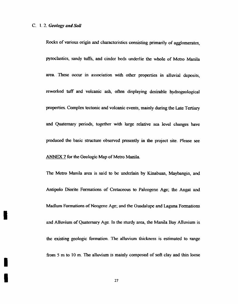
C. 1. Physical Resources
Ic. 1.1. Topography
Metro Manila is characterized by three (3) distinct land fonns, namely, the
elavated undulating area; the Marikina Valley and adjoining fault escarpments;
and the flood plain areas extending towards Manila Bay.
25
I
I Pasay City, in general, is situated in acoastal plain. The reclamation area on
I Roxas Boulevard, west of the city, acts as its buffer zone. Thus, its physiography
is characterized as former and tidal flats. Zones 1 to 15; and Zones 17 and 18 lie
in the fonDer tidal flat area; while the western part , Zones 16, 19 and 20 are in
the active tidal flats.
I A greater portion or approximately seventy -five per cent (75%) of Zone 19
.
(which includes the Civil Aeronautics Administration, the present NAJA. and the
Source: Directional Plan of the Philippines Population Management Program
Department of Health Pasay City, Metro Manila
C. 3. I. l.a. Population Growth
Population change is mostly attributed to migration. Nevertheless indicative
population growth rates among the various zonal districts of the city showed that
Zone 20 registered the highest growth rate due mainly to the proliferation of
squatters in the area. Zone 6, a blighted district registered second highest growth
rate, while Zone 3, a commercial area revealed the lowest growth rate. These
Ijndicated the continuing jnflux of migrants into low income areas. Zone 19 where
39
the proposed NAJA IPT 3 project will be set up, registered a growth rate lower
than that of Zones 20 and 6, but slightly higher than that of Zone 3.
C. 3. 1. I.b. Population Density
I
.
square kilometer. This indicates congestion which is one of the more serious
problems faced by the city. The most congested parts of Pasay City are: Zone 1,
Zone 8, Zone 13, Zone 18, Zone 17, Zone 19, Zone 2, Zone 7, and Zone 11. Zone
20 exhibited a population density lower than the regional average.
I The main cause of the extremely high density of Pasay City is concentration in
commercial establishments. People from the provinces who have found
employment in the City's commercial establishments, eventually settle in the
area. At the rate her population is growing, Pasay City could have a density of
31,131 persons per square kilometer by the year 2000. This figure would be way
above tolerable limits.
40~
I
twelve per cent (12 %), health services at eleven per cent (11 %), educational at
seven per cent (7 %), and other types of services at fourteen per cent (14 %).
Commercial activities are distributed as follows:a) most of the wholesaling of
construction materials are along EDSA; b) establishments selling motor vehicle
parts are located along Taft Avenue; c) retailing of home furnishings are along
Taft Avenue; d) gasoline stations are clustered along Harrison; banking services
are along Libertad Street and Taft Avenue; e) and restaurants and night clubs and
cocktail lounges are along Roxas Boulevard
In terms of percentage, wholesale takes up twenty-two per cent (22 %); retail, five
per cent (5 %); other types of services forty-nine per cent (49 %).
The medium industrial area in Pasay City is the Malibay District which covers
Zone 16, Zone 17, and Zone 18. In addition the light industrial area is located
beside Tripa de Gallina, covering Zone 6, Zone 8, Zone 13, and Zone 15. The
presence of the secondary drainage divides in Zone 17 and Zone 18, and the
43
I
stream passing thru Zone 16 and Zone 18 is the main feature which attracted the
medium industries to locate in the areas.
.
I C. 5. Infrastructural Facilities
-C. 5.1. Water Supply
The water supply of Pasay City comes from MWSS. However, due to existing
defects in the distribution system, only eighty-eight per cent (88 %) of the city's
I total area has water supply. Among the seven districts of Pasay City. Malibay
experiences the most serious water shortage.
IIn additi°I? to the water supply from MWSS, the City Government of Pasay
constructed several extension wells and deep wells. However, water from these
wells is unfit to drink, and is merely used for washing. Salt water intrusion is
heavy in the City. such that in many areas nearer Manila Bay. water from these
wells are unifit for drinking.
I
I
I
C. 5. 2. Sewerage
Pasay City has no sewer line. The sewerage system is connected to the drainage
system.
-C. 5. 3. Rood Control and Drainage
There exist natural drainage in Pasay City. These are the creeks. One such creek
I which acts as the divider between the City Proper and the CAA Compound is
I quite deep, and serves Zone 16, Zone 17, and Zone 18. The creek empties into the
I Paranaque River.
IIn addition there are two (2) interceptors with pumping stations located in
Buendia Avenue and Libertad Street, which handle excess water from minfall,
and prevent flooding.
C. 6. Transportation
IC. 6.1. Roads
Pasay City has a total of 149.35 kilometers of road. Approximately forty per cent
while(40 %) or 59.398 kilometers are classified as National Roads;
4~
approximately sixty per cent (60 %) or 89.962 kilometers are City Roads.
Seventy-five per cent (75 %) of the roads is concrete. fifteen per cent (15 % )
asphalt, and only ten per cent (10 %) gravel
I The major thoroughfares in Pasay City are Roxas Boulevar~ EDSA. Aurora
.
Boulevar~ Domestic Road, Harrison Street, Libertad Street, Leveriza Street, Taft
Avenue, Buendia Avenue and Andreww Avenue. EDSA is a circumferential road
starting from Paranaque, passing through Pasay City, Makari City, Mandaluyong
I City, San Juan, Quezon City to Caloocan City.
C. 6. 2. Airports
Both the existing Domestic Passenger Terminal and NAJA International
Passenger Tenninal are claimed by Pasay City as within her jurisdiction.
IC. 7. Land Planning
C. 7. 1. Existing Land Use
IThe largest area in Pasay City is devoted to utilities. These are situated in Zones
19 and 20, and have a total land area of9.5 kilometers or approximately fifty one
46
per cent (51.35 %) ofPasay City's total land area. The rest of the City's land area.is divided among the different land uses, Zones 5, 10, 11, 14, and 16 are
predominantly commercial zones. Zones 1,2,3,4,6,7,8, 12, 13,17, and 15 are
I generally residential area. Zone 18 is an industrial area. while Zones 9 and 10
.
have a mixture of institutional, residential, and commercial uses.
C. 7. 2. Potential Land Use
I It is in the drawing tables of Pasay City 10 retain the existing, commercial strips
I in the City's major roads or thoroughfares. However, there will be limitations to
only a block or two blocks deep at the most. An example of this is the area along
Taft Avenue, with a one-lot deep commercial strip on both sides. Commercial
activities will be allowed, at the most" only two (2) blocks on its side.
IAccording to the City Planning Office of Pasay City, most of the Zones with
dominant residential uses will be retained, and commercial strips in such areas
Ishall be controlled such that no new similar structures will be allowed to be set
up. Thus Zones 8, 12, 13, 15, and 17 shall be purely residential. Mixed land use
47
will be allowed in Zones 1, 2, 3, 4, 6, 9, and 14 for residential and commercial
uses. Zones 5. 10. and 11 will be considered as commercial zones.
uses. For Zone 18, an industrial area, development shall be controlled. Thus, for
instance, the existing tires and paints manufacturing establishments will not be
allowed to renovate or expand their existing factories in the said Zone 18.
IHowever, non-pollutant industries will be encouraged to locate there, and those
I
Ialready existing will be allowed to expand Zone 19 where the proposed NAJA
I 1FT 3 will be located will continue to be classified in the City zoning as utilities
I (transportatio~ airport, communicatio~ etc.).
I C. 8. Power Sources and Transmission
I Electric power source is from MERALCo. Please see ANNEX 12 for indication
ofHf transmission lines.
48
I
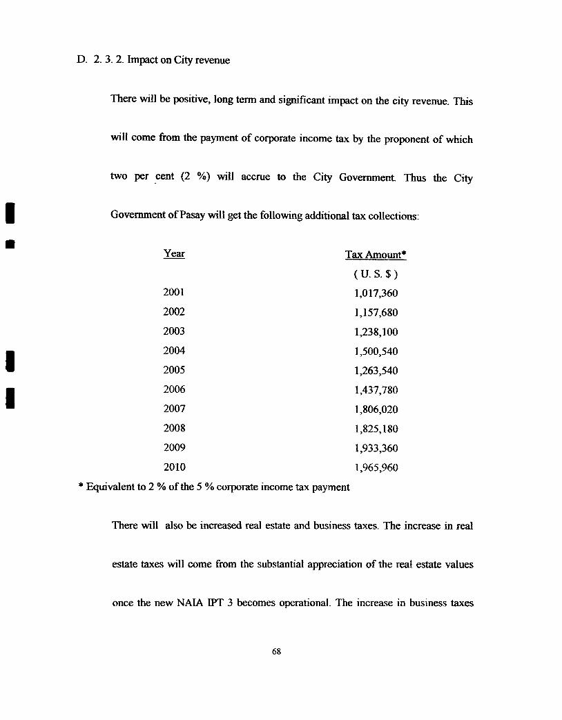
D. ANllCIP A TED ENVIRONMENTAL IMPACTS' AND MITIGATION-I MEASURES
.
D. 1. During Construction Stage
D. 1. 1. Physical Environment
D. 1. 1. 1. Water Quality and Quantity
Earthwork, soil excavation, building construction, and ground preparation may
cause siltation! tubidity of Manila Bay and the river. The potential siltation of
Manila Bay will be practically since the project site is far removed from Manila
Bay. The potential siltation ofParanaque River due to the project is insignifican~
short term and reversible. During construction the estimated daily water
requirement both for personal use and for construction purposes has been
estimated at 250 cu. m. for personal use; and some 500 cu. m. for construction
purposes. It is expected that this daily increase in water demand of approximately
750 cu. m. will not affect the supply of water to the Residents of the City, because
49
I by ]999 two (2) new pumping stations of MAYNILAD WATER SERVICES,
-INC. will be operated and provide an additional! ,200 MLD of water.
D. 1. 1.2. Air Quality-The existing level of TSP based on the sampling conducted on 10 March 1998 is
.
from 212 J.lg/Nm3 to 801 J.lg/Nm3. This is above the ambient air level standard
for TSP of230 J.lg/Nm3.
Earthwork, soil excavation, ground preparation, and concreting activities will
increase the TSP during construction to a mOderately significant level, but
temporary and reversible in nature. More so since a comprehensive system of
netting will be used to control the spread of dust or particulate matter. Constant
watering of the ground to control dust will be regularly undertaken on a daily
basis.
Operation of heavy equipment such as bulldozer and excavator will cause
emission of carbon monoxide that will add minimally to the present deterioration
50
of air quality condition of the vicinity. This effect is moderate but reversible and
short term. (please see ANNEX 8-A)
D. 1.1.3. Fire Hazard
During the construction stage there will hardly be any fire hazard if none at all,
because no combustible material, will be used, nor will fires be ignited.
I D. 1. 1.4. Solid Waste
IDuring the construction stage, solid waste will be generated by some five hundred
(500) workers at the site at the rate of 0.2 kg! person! day or a total of one
hundred (100) kg. per day of wet and dry refuse. Solid waste will also be
I generated Disposable solid waste shall be stored in a 20' x 20' cargo van prior to
Ibeing collected daily by the Sanitary Engineers' office ofPasay City.
I
D.
1. 2. Ecological Environment
No increase in turbidity of Paranaque River and Manila Bay, which may affect
aquatic life that is thriving at the said surface waters will be generated during the
Construction stage. (Please see ANNEX 8-B)
I
I 51
I
D. 1.3. Socio-cultural-economicEnvironment
The project has a positive high impact which is long tenD and irreversible-
employment to Pasay City constituents.
It has also a negative moderate impact, which is the generation of solid waste
I from the construction activities and from workers temporarily residing at the
project site.
.D.
2. Environmental Impacts After Construction and During Commercial
Operation
D. 2. 1. Physical Environment
D. 2. 1. 1. Air Quality
During commercial operatio~ it is expected that no significant impact on air
quality within the area will be caused. The terminal building will be fully air
Iconditioned and equipped with dust filtration system. No significant smoke will
be generated by the potential restaurants and other eating and drinking
Iestablishments.
I
I 52
D. 2. 1. 2. Noise
I NAIA was projected as follows:
Projected Number of Aircraft 1/
High Forecast
44,180
Medium Forec~
44,180
Low Forecast;:--
44,180~1996
72,10067,400
72,300
61,700
65,200
200178,300
200279,70077,50068,900200380,100
72,900
77,000
2004
2005
79,700
79,900
79,100
78,300
78,9002006
80.500
79.200
78.00078,5002007
2025 71,900 59,700
1/ Low Forecast was made by PlATCO; the Medium and High Forecasts were made byHalcrow. From the year 2007 to 2025, the assumption was made that other flightswould be diverted to Clark International Airport, since the NAJA IPT 3 would havealready reached the 10 million passenger capacity for three (3) consecutive years.
Please see ~:I;;X 8:12..
65,300
.I
53
II
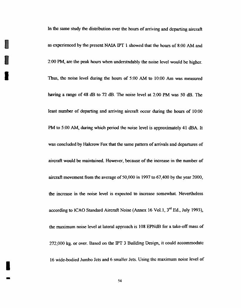
In the same study the distribution over the hours of arriving and departing aircraft
as experienced by the present NAJA IPT 1 showed that the hours of 8:00 AM and
2:00 PM, are the peak hours when understndably the noise level would be higher.
I Thus, the noise level during the hours of 5:00 AM to 10:00 Am was measured
having a range of 48 dB to 72 dB. The noise level at 2:00 PM was 50 dB. The
least number of departing and arriving aircraft occur during the hours of 10:00
PM to 5:00 AM. during which period the noise level is approximately 41 dBA. It
was concluded by Halcrow Fox that the same pattern of arrivals and departures of
aircraft would be maintained. However. because of the increase in the number of
aircraft movement from the average of 50,000 in 1991 to 61,400 by the year 2000,
the increase in the noise level is expected to increase somewhat. Nevertheless
according to ICAO Standard Aircraft Noise (Annex 16 Vol.l, 3M Ed., July 1993),
the maximum noise level at lateral approach is 108 EPNdB for a take-off mass of
272,000 kg. or over. Based on the IPT 3 Building Design. it could accommodate
16 wide-bodied Jumbo Jets and 6 smaller Jets. Using the maximum noise level of
I-
S4
I 108 EPNdB per aircraft, total noise level is 118.6 dBA on the assumption that all
I
these aircrafts are veering up. Using acceptable noise standard for an Airport of
65 CNEL (San Francisco International Airport), it is estimated that for the years
2001.2007. and 2025. the CNEL wil be 32. With this estimated level there will
be no breach of standards. CNEL=84.2-2] Jog] 0 D + Jog] 0 N, where D=distance,
N=no. of aircraft per day. Using D=4oOrn, N=145 (2001), 160 (2007), & 160
(2025).
D. 2. 1.3. Sufficiency of Domestic Water Source
Following a meeting between PIATCO and Maynilad Water Services, Inc. on
7 November 1997, it was conflmled that Maynilad could fully supply the
3,000 cu.m. daily requirement ofNAIA IPT 3.
Water supply to the NAIA IPT 3 will come from the existing 400 mm diameter
main along Tramo Road. This diameter main is supplied from the 1,650 mm.
diameter feeder along EDSA, which is connected to the Pasay Pumping Station
and Reservoir.
I 55
Additional tapping for the proposed NAJA IPT 3 will be from the existing 900
mm diameter water main along South Super Highway. which is being supplied
I from Fort Bonifacio Pumping Station and Reservoir. In addition. A 1,200 mm
I diameter water main has been proposed to be laid along the South Super Highway
-under the existing project termed as Mani]a South Water Distribution Project.
This will include a new Fort Bonifacio Pumping Station no. 2 expected to be
I operational by 1999, these two water supply projects will provide an additional
1,200 Mill of water. more than enough to supply the projected need of the
proposed NAJA IPT 3. On 19 May 1998, a team from Alan Stratford &
Associates met with Maynilad Water Services, Inc. to reconfirm the commitment
of the latter to fully supply the water requirements. It is expected that the
estimated daily water demand of approximately 2,500 cu. m. will easily be
provided without causing any shortages for the communities.
56
ID. 2. 1. 4. Water Quality
Waste water effluent is estimated to reach approximtely 2,000 cu. m. per day. It
was logically assumed that the balance of 500 cu.m. per day would be either used
I by the air conditioning system (cooling tower); and! or to water lawns and other
.
ornamental plants. A substantial amount would evaporate; would be spilled on the
ground; and would be used as drinking water by well-wishers who discharge later
outside of the Terminal. The water quality of effluent from the sewage treatment
plant and from the various establishments in the proposed NAJA IPT 3 project
will be closely monitored to detennine water pollution indices such as TSS, E.
COLL that are beyond pennissible limits set in the national water quality
standards as a result of possible systems failure.
The pollution indices will include physical, chemical, and bacteriological
characteristics of the treated waste water. The proposed NAIA IPT 3 will have its
own sewage treatment plant which will use one of three (3) effective
Further, the cost-benefit analysis must compare the negative impacts with the
socio-economic benefits to be derived from the proposed NAJA IPT 3 project.
The direct negative sociological impacts of the NAIA IPT 3 will relate primarily
to the Airmen's Village. There will be a significant displacement of or change in
neighborhood composition particularly on the 3ro~ Manlunas, and Andrew Streets.IThe residents will also lose facilities such as:I
I. The Villamor Air Base Elementary School;I
I 2. The Pasay City South High School;
I 3. The Philippine State College of Aeronautics;
I 4. The barangay facilities; e.g. the barangay hall, Menzi Park, Village
I Health Center, and gymnasium;
I 5. Portion of the Concessionaire's area;
I 6. The St. Therese of the Child Jesus; and
7. PAF facilities
I
I125
I
IThey will also be temporarily subjected to those nuisances normally created by
major construction, including increased noise levels, dust, heavier traffic on
Andrew Avenue and other similar effects. On a permanent basis, the traffic and
noise from terminal activities will cause some disturbances, which will be
directly proportional to the incoming and outgoing type of aircraft.
IFrom the negative economic standpoint, there will be some direct costs related to
the relocation site of the affected resident and facilities. However, the project
otTers several beneficial impacts on both a temporary and permanent basis.IConstruction will require approximately 500 laborers of varying trade and skillIlevels. A foreign exchange inflow of 350 million US Dollars will improve the
foreign exchange reserves of the country. A large percentage (70 %) of the labor
would require no specific skill or training. and thus would provide work for those
in our society, who are finding it most difficult to secure a job. This could have
some impact on welfare and unemployment compensation.
126
Estimates project that the facility will spend about 30 million US Dollars per year
on direct purchases. This money should also boost the production and sales of
many local industries such as food, steel, wood, furnishings, other construction
materials.
The result of the money put into circulation by the implementation of the project
will be its continuous circulation among the recipients. Beyond that, at least 40
.
Million US Dollars revenue from tourism related activities would also be
I realized. This is called the multiplier effect. Without an extensive study, a factor
of 2(x) would be a conservative figure. Based on the 30 Million USD spent each
year, the total direct and indirect contributions of the facility to the Philippine
economy will total 12 million USD per annum.
The terminal will generate revenues for Pasay City. These funds will not only
compensate for construction costs, but will act as long-term source of revenues.
The NAIA IPT 3 will accommodate an average of 6,000 arriving and departing
international passengers per day. Beyond the more obvious benefits lies another
127
Not proceeding with the IPT 3 would considerably pacify a minority segment of
opposing Ainnen's Village Homeowner's Association advocating the retention of
schools. church, and community center at their present site. However. this will
result in congestion of passengers and eventual loss of revenues to the national
Iand local governments.
IIIIII
129
K. CONCLUSION
K. 1. Over-all Net Gains
The over-all net gains which justify the implementation of the proposed NAJA
IPT 3 project are as follows:I
A At long last an international passenger terminal adequate to handle 13
million passengers annually, and architecturally at par if not better than
I the existing international airports around the world, will be realized as
I truly the primary gateway to the Philippines.
B. Employment opportunities will be created as follows:
a. During Construction
Direct Labor 500 persons1
2. Indirect Labor 1,000 persons
b. During Operation
2,500 persons1 Direct Labor
10,000 persons2. Indirect Labor
130
The Philippine Government is guaranteed to earn a total ofc.
Twelve Billion Five Hundred Million Pesos (p
12,500,000,000.00) from the operation of the proposed NAJA
IIPT 3 project.I
d Incremental foreign exchange will start with the initial inflow
of the u.s. $ 350 million loan. During commercial operation of
the project additional foreign exchange inflows will come from
.
I approximately six million five hundred thousand (6,500,000)
arriving passengers who would spend U.S. $ 600.5 million at
an average expenditure of U.S. $ 100.00 per aIriving
passenger.
e. Increased Income Tax Earnings by the Philippine Government
from both the project itself and from the many addtional
employment that will have been created The proposed project
ofitself is projected annual taxto pay an Income
131
I
approximately P 50 million, while income tax to be paid by the
roughly 14,000 employment opportunities created would total
around P 10 million annually.
f.I
The calculated IRR of the proposed NAJA IPT 3 project is
twenty-one per cent (21 %).IK. 2. Adverse Effects
The following adverse effects will be minimized or off-set
How Minimized or Off-setAdverse Effect
a. During Construction
1) Relocation of disrupted residents 1) BCDA has already completed plans for
the relocation of 192 families to a
newly built high rise condominium far
better than the old apartment buildings
they presently occupy
2) Silt runoff from unprotected cut- 2) There is a drainage and flood control
and-fill areas plan
I3) Hazard to workers' safety 3) There will be strict adherence to
I wearing of gloves, boots, helmet and
other safety devices while at work.
There will be signs posted at
conspicuous areas alerting personnel
I
I132
I
Elementary School, Pasay City South High School, and St. Therese of the Child
Jesus Church.
Finally, the residents of the Airmen's Village will be subjected to both temporary
I and pemlanent increases in noise levels, which however in temls of level and
I time occurence andfd distribution will not result in major impact.
The construction of the proposed project will assure optimum use of a section of
I unused land owned by BCDA, Although it will result in a few limited temporary
I environmental adverse effects, the life expectancy of the terminal's productivity
will prove profitable to society on both a regional and local basis.