26
Phillip R. Owens Purdue University Associate Professor, Dept. of Agronomy

Phillip R. Owens Purdue University
Associate Professor, Dept. of Agronomy


Old way of getting soil information


Land Resource Areas in 1981
26 Land Resource Regions (A-Z) and 204 MLRAs

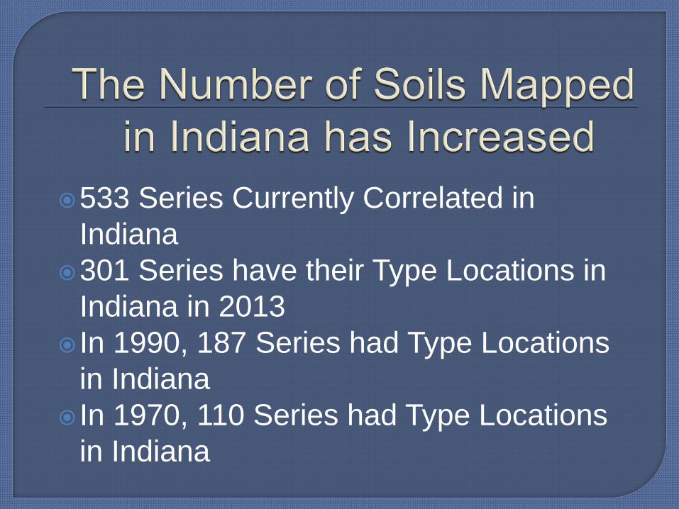
533 Series Currently Correlated in Indiana
301 Series have their Type Locations in Indiana in 2013
In 1990, 187 Series had Type Locations in Indiana
In 1970, 110 Series had Type Locations in Indiana

Digital Soil Survey Products


Fc – Fincastle: Fine-silty, mixed, superactive, mesic Aeric Epiaqualfs
Bs – Brookston: Fine-Loamy, mixed, superactive, mesic Typic Argiaquolls
Kk – Kokomo: Fine, mixed, superactive, mesic, Typic Argiaquolls
Pa – Patton: Fine-silty, mixed, superactive, mesic, Typic Endoaquolls
Ca – Carlisle muck: Euic, mesic, Typic Haplosaprist
Soil Survey Map
Limitations •Soil Survey has hard boundaries • Up to 2 acres of inclusions • Interpretations are not based on management • Created using best available technology at the time

Most occurred in the Soil Surveys Updated after 1998 (see Publication Map)
Counties within Hoosier National Forest were updated to make uniform legend throughout HNF
Marshall County was also updated but w/o new publication

Some will occur in the older Soil Surveys mapped before 1975 (see Publication Map)
Some will occur in counties adjacent to surrounding states to make better joins between states
Counties with Inactive Series and Variants will have updates

Some large map units will be split into phases by physiographic regions or landforms, for example Blount, Lake Michigan Lobe
Some map units not correlated to series level, like orthents or Made land, may be changed to fill in data gaps
Some substratum phases or taxadjuncts may become new series or map units

Future Changes in Series Names will be less than in the recent past
Most changes will occur in the tabular data for each map unit
Some soil lines will be adjusted with LiDAR and other new technology to make lines better fit landforms

In the USDA Soil Survey prior to now – Based on the Didericksen Model
When calculated in 1979 – average yield in Indiana was 100 bu/acre
This model adds yield for good soil properties and deducts for poor soil qualities

Better plant genetics
Better technology
Better management
Since 1940 – yields have increased by over 1.5 bu/acre/year

Based on the natural soil – not based on management or improvements – Didericksen Model
Uses properties such as slope, organic matter, plant available water, rooting depth, drainage, sand content, clay content, and many others.
Each property is plus, minus or 0 yield.

Purdue is using the Didericksen Model to develop soil ranking factors – not soil productivity factors
Ranking factors will be based on the soil’s potential to produce corn without management factors included

The data in Soil Survey requires updates, including the interpretations such as the better estimates of yield
The increase in yield from USDA Soil Survey better reflects the soils potential for producers
We are providing a soil ranking factor to provide assessments of a soils potential without management included.

Contact information: Phillip R. Owens, Soil Scientist Purdue University Phone – 765-494-0247 E-mail – [email protected]


