24
WELCOME VIRTUAL PUBLIC INFORMATION CENTRE Regional Road 50 (Niagara Street) Bridge Reconstruction City of Welland Thursday March 4, 2021 6:00p.m.

WELCOMEVIRTUAL PUBLIC INFORMATION CENTRE
Regional Road 50 (Niagara Street) Bridge Reconstruction City of Welland
Thursday March 4, 20216:00p.m.
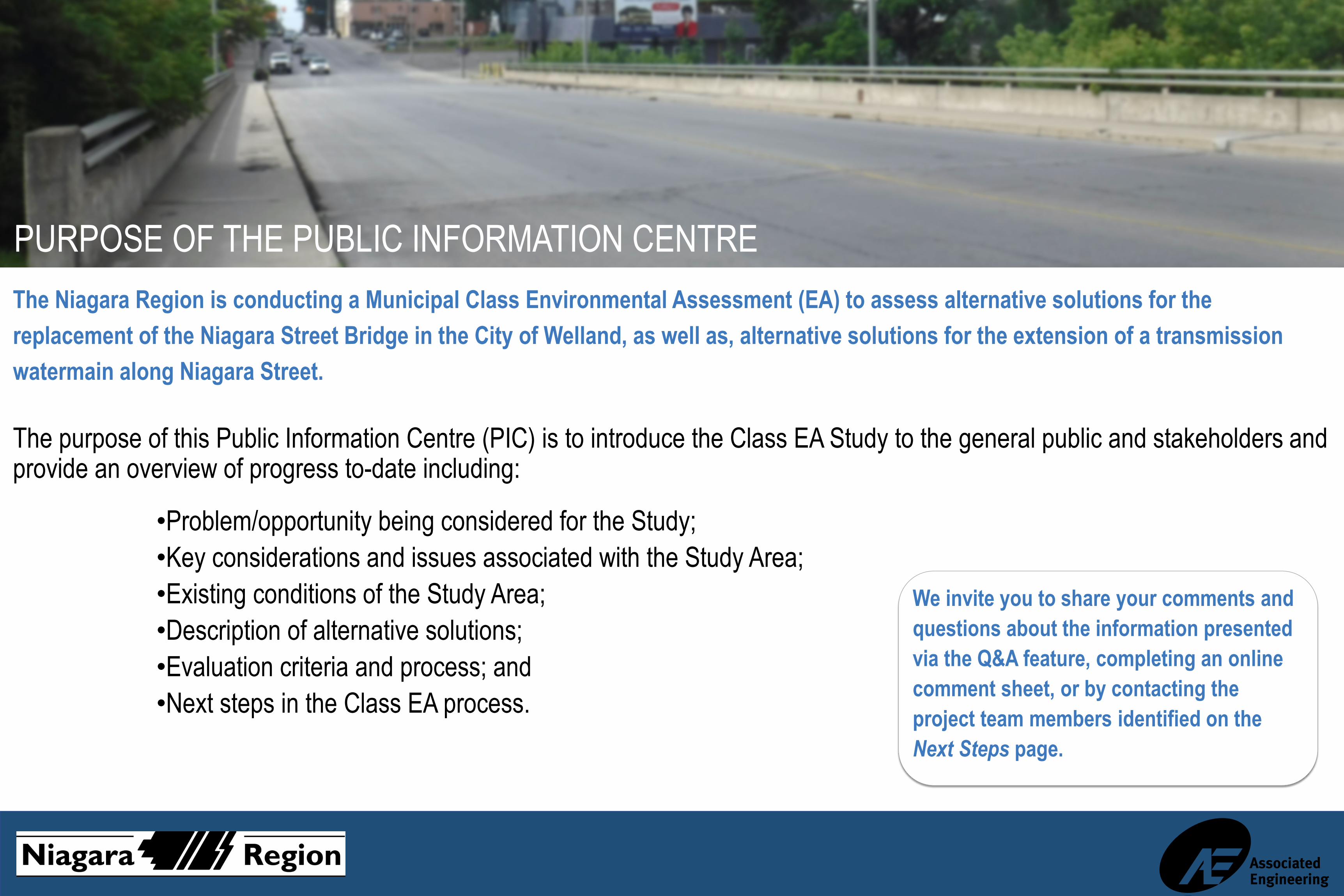
PURPOSE OF THE PUBLIC INFORMATION CENTREThe Niagara Region is conducting a Municipal Class Environmental Assessment (EA) to assess alternative solutions for the replacement of the Niagara Street Bridge in the City of Welland, as well as, alternative solutions for the extension of a transmission watermain along Niagara Street.
The purpose of this Public Information Centre (PIC) is to introduce the Class EA Study to the general public and stakeholders and provide an overview of progress to-date including:
•Problem/opportunity being considered for the Study;•Key considerations and issues associated with the Study Area;•Existing conditions of the Study Area;•Description of alternative solutions;•Evaluation criteria and process; and•Next steps in the Class EA process.
We invite you to share your comments and questions about the information presented via the Q&A feature, completing an online comment sheet, or by contacting the project team members identified on the Next Steps page.
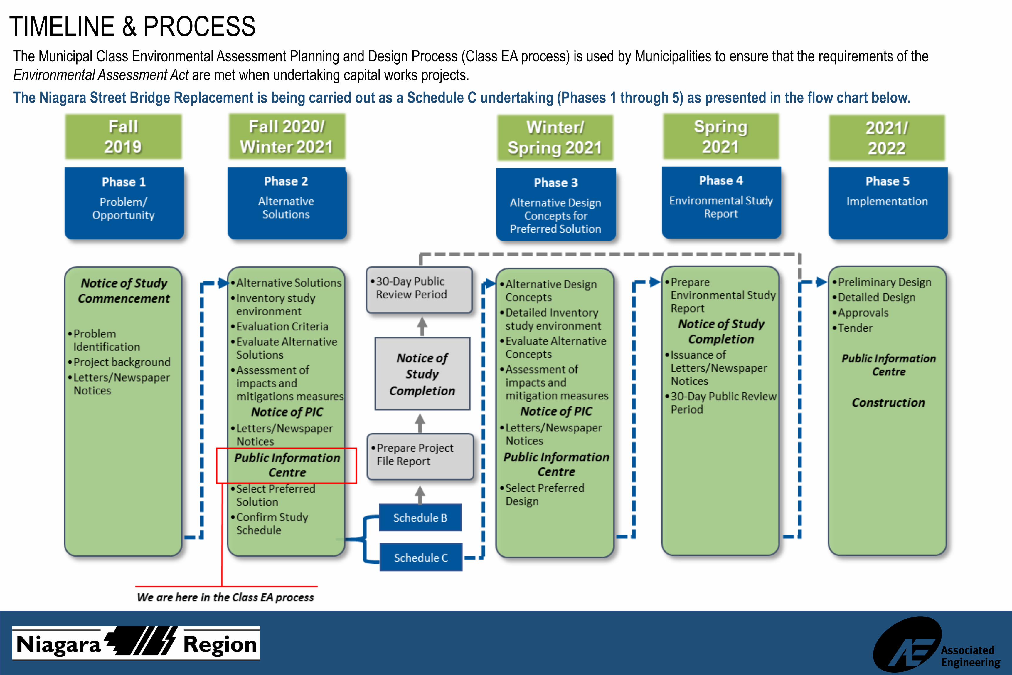
TIMELINE & PROCESSThe Municipal Class Environmental Assessment Planning and Design Process (Class EA process) is used by Municipalities to ensure that the requirements of the Environmental Assessment Act are met when undertaking capital works projects.The Niagara Street Bridge Replacement is being carried out as a Schedule C undertaking (Phases 1 through 5) as presented in the flow chart below.

ABOUT THE STUDYDefining the Problem:•The Niagara Street bridge structure (circa 1932) is a four span, 68m long, slab on concrete girder bridge that has been identified as needing replacement due to the age and condition of the structure. Previous structural inspections of the bridge identified severe areas of concrete spalling, cracking and deterioration on the structure.
•In addition, to provide needed additional supply capacity to the area, an extension of the 600mm transmission main at Riverbank Street to the 600mm transmission main at Mill Street is required.
•Given the need to replace the Niagara Street bridge, there is an opportunity to address structural deficiencies, improve public safety of all modes of transportation (vehicular, cyclist, and pedestrian), and provide secure water supply to the surrounding area.
The Study Area includes the Niagara Street (Regional Road 50) Bridge and roadway approaches (between Riverbank Street and Mill Street).
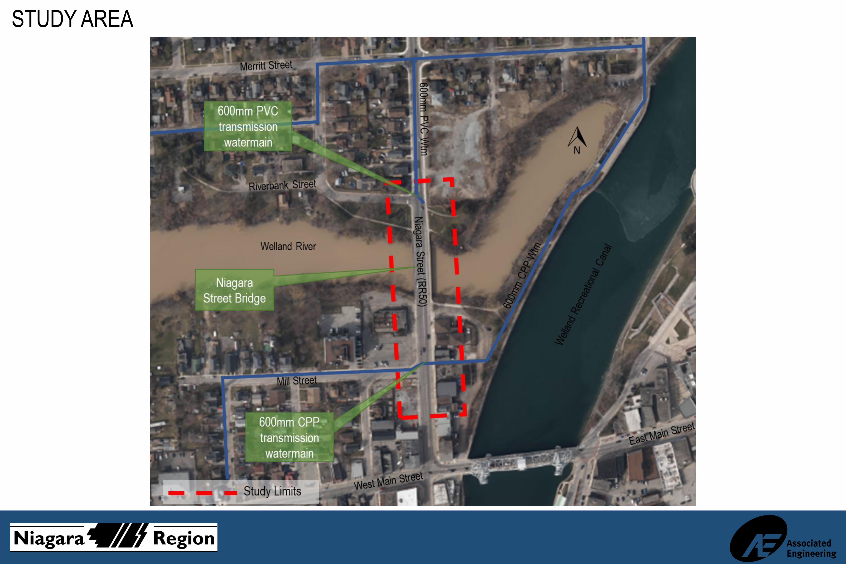
STUDY AREA

KEY CONSIDERATIONSKey issues and considerations for the Study Area include:•Active transportation connectivity including cyclist and pedestrian facilities
•Security of water supply•Environmental sensitivities •Existing subsurface conditions •Existing utilities •Property acquisition •Aesthetics
Several baseline condition studies have been completed, including the following: •Structural Condition Assessment•Cultural Heritage Assessment•Archaeological Assessment•Natural Environment Impact Assessment •Geotechnical and Soils Investigation •Hydrogeological Assessment •Infrastructure Inventory
The findings and recommendations of the listed studies support the development of alternative solutions, design concepts and completion of the evaluation process.

EXISTING CONDITIONS: NIAGARA STREET BRIDGE•Carries Regional Road 50 (RR50), a major north-south arterial roadway, over the Welland River.
•The bridge is located west of the downtown core, serves an average annual daily traffic (AADT) of 12,400 and provides access to residential, commercial and industrial uses.
•The bridge structure was originally constructed in 1932, underwent extensive rehabilitation works in 1973 and interim repair works in 2019.
•The existing structure is 68m long with four spans and has a cross-sectional width of 18.3m consisting of two travel lanes (including shoulders) of 7m width each and sidewalks and parapet walls on both sides.
•The superstructure is a reinforced concrete slab on 28 pre-stressed concrete girders with an asphalt wearing surface which was reconstructed in 1973.
•The substructure consists of reinforced concrete abutments and three concrete piers all supported by timber piles and are original (circa 1932).

EXISTING CONDITIONS: CULTURAL HERITAGE
•A Cultural Heritage Resource Assessment (CHRA) and Cultural Heritage Evaluation Report (CHER) were completed for the Study Area.
•Five (5) potential features identified with cultural heritage value.
•The cultural heritage value of the bridge structure was evaluated and determined not to have any cultural heritage significance.

EXISTING CONDITIONS:ARCHAEOLOGICAL
•A Stage 1 Archaeological Assessment was completed of the Study Area.
•The Study Area does not retain archaeological potential on account of deep and extensive land disturbance, low and wet conditions, or slopes in excess of 20 degrees.

EXISTING CONDITIONS: NATURAL ENVIRONMENT•The Study Area crosses the Welland River and is within NPCA regulated lands.
•NPCA and MNRF mapping identify wetlands and woodlots within the vicinity of the Study Area.
•Welland River West Wetland Complex (a Provincially Significant Wetland) is located upstream of the bridge (> 100m); however, likely no real potential for impacts.
•There is potential for Eastern Pondmussel(Ligumia nasuta), a freshwater mussel SAR (Species at Risk), in the Welland River.
•Observed Barn Swallow (Hirundo rustica) nests, a bird SAR, under the bridge. •Mitigation will be required during construction to minimize impacts to natural environment sensitivities and SAR.
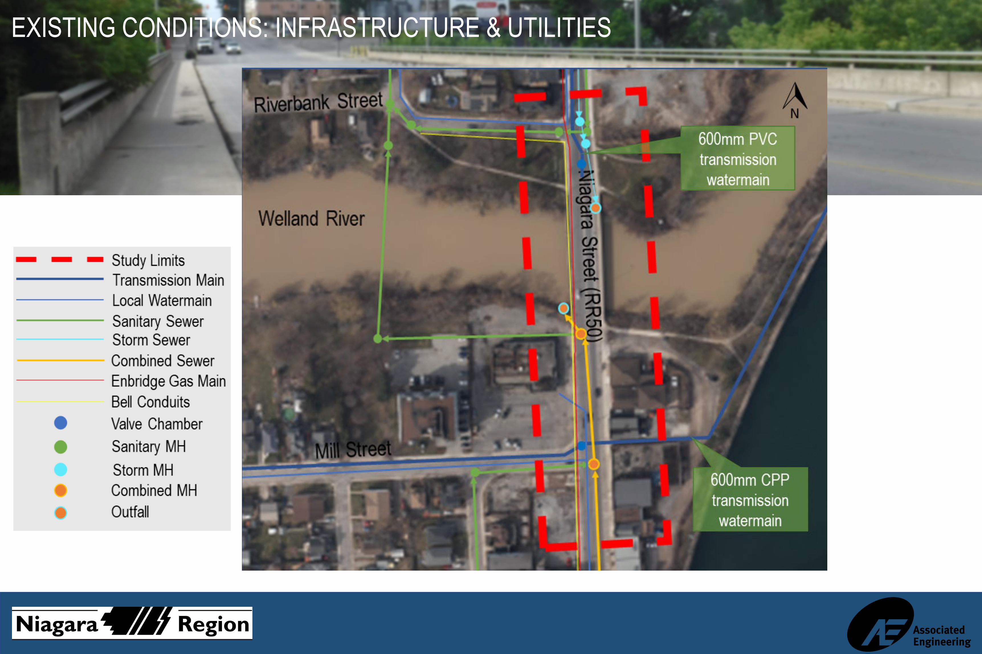
EXISTING CONDITIONS: INFRASTRUCTURE & UTILITIES

BRIDGE REPLACEMENT ALTERNATIVE SOLUTIONSThroughout the Municipal Class EA process the following Alternative Solutions are being considered for the bridge replacement:
ALTERNATIVE #1:Do Nothing
The existing Niagara Street bridge structure remains in its existing condition. The interim bridge repairs completed in 2019 will prolong the bridge’s service life for approximately 5 years, at which time additional bridge repairs or rehabilitation works will be required. Due to the age and condition of the structure, this alternative is not considered feasible but has been considered as a benchmark for comparison.
NIAGARA STREET BRIDGE (UPSTREAM LOOKING EAST) NIAGARA STREET BRIDGE (LOOKING NORTH)

BRIDGE REPLACEMENT ALTERNATIVE SOLUTIONS
ALTERNATIVE #2:Replace superstructure utilizing existing piers
Remove and replace existing bridge superstructure with 14.8m wide cross-section. The cross-section would include two 3.5m travel lanes, two 1.8m bicycle lanes, and two 1.8m wide sidewalks. The new superstructure could consist of girders, concrete deck (225mm depth) and asphalt surface. The new superstructure would have negligible impact on the road vertical profile and available freeboard. This alternative would maintain the three (3) existing piers; however, the piers would be rebuilt fromthe sheetpiling (above waterline). The abutment walls would also be rebuilt due to existing deterioration.
CROSS-SECTION: ALTERNATIVE 2 ELEVATION: ALTERNATIVE 2

BRIDGE REPLACEMENT ALTERNATIVE SOLUTIONSALTERNATIVE #3:Replace with new superstructure and
substructure
Replace existing bridge with new structure (superstructure and substructure). Bridge would have similar cross-section and width (14.8m) as Alternative 2. The existing piers would require complex removal to riverbed with new piers (1 or 2) being constructed. The abutment walls would also be rebuilt due to existing deterioration. The new superstructure could be either steel girder (950mm) or concrete box (B1000) with concrete deck (225mm depth with steel or 150mm depth with concrete) and asphalt surface. The new superstructure would have negligible impact on the road vertical profile and minor impact on the available freeboard.
CROSS-SECTION: ALTERNATIVE 3 ELEVATION: ALTERNATIVE 3

BRIDGE REPLACEMENT ALTERNATIVE SOLUTIONS
ALTERNATIVE #4:Replace with new single
span structure
Replace existing bridge with new single span structure (superstructure and substructure). Bridge would have similar cross-section and width (14.8m) as Alternative 2. The existing piers would require complex removal to riverbed and the abutment walls would also be rebuilt due to existing deterioration. The new superstructure could be either steel girder (3000mm) or steel tub (2700mm) with concrete deck and asphalt surface. The new superstructure would impact the road vertical profile and available freeboard due to the increased depth of the superstructure.
CROSS-SECTION: ALTERNATIVE 4 ELEVATION: ALTERNATIVE 4

EVALUATION CRITERIA – BRIDGE ALTERNATIVE SOLUTIONSThe evaluation criteria that was used to evaluate the bridge alternative solutions includes:
TRANSPORTATION •Ability to serve the existing and future vehicular, pedestrian and cycling traffic needs
TECHNICAL•Ability to address technical requirements (structural load, etc.)•Ability to construct the replacement in a cost-effective manner•Consideration to constructability and complexity of construction •Consideration for construction length and detouring/staging
NATURAL ENVIRONMENT•Direct and indirect impacts on the existing vegetation, water quality, watercourse, fisheries/wildlife habitat
•Consideration for hydraulic impact on Welland River
SOCIO-ECONOMIC ENVIRONMENT •Impacts on the local community including property requirements•Impacts on utilities•Impact on the local businesses, residents and road users
CULTURAL ENVIRONMENT •Potential adverse effects on the existing archaeological and heritage resources
FINANCIAL•Capital cost of the alternative
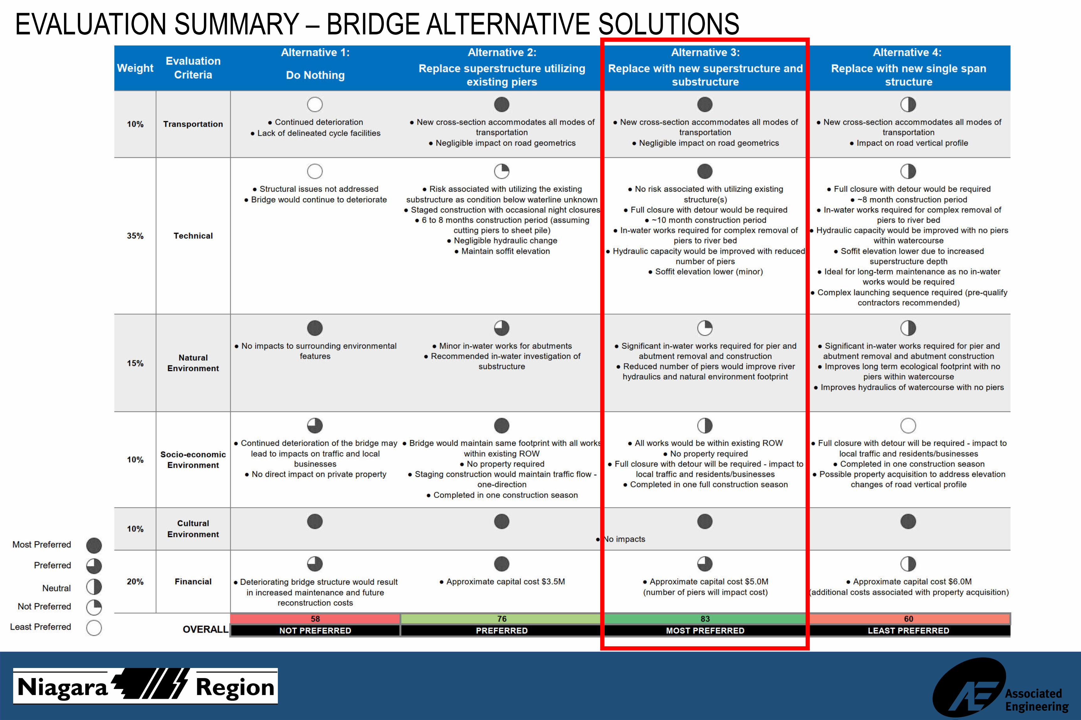
EVALUATION SUMMARY – BRIDGE ALTERNATIVE SOLUTIONS

WATERMAIN CROSSING ALTERNATIVE SOLUTIONSThroughout the Municipal Class EA process the following Alternative Solutions are being considered for the watermain crossing:
ALTERNATIVE #1:Trenchless Crossing
The new 600mm diameter watermain crossing would be installed via trenchless technologies. Trenchless technologies to be explored as feasible methods include Horizontal Directional Drilling (HDD) and micro-tunneling (MTBM). Key considerations will include watermain alignment, entry and exit locations and soil/ground conditions.
HORIZONTAL DIRECTIONAL DRILLING SCHEMATIC
MICRO-TUNNELING SCHEMATIC

WATERMAIN CROSSING ALTERNATIVE SOLUTIONS
ALTERNATIVE #2:Independent Pipe Bridge
The new 600mm diameter watermain crossing will be installed on an independent pipe bridge located upstream or downstream of the Niagara Street bridge structure. Key considerations include location of pipe bridge, ability to accommodate additional utilities (i.e.: Enbridge), functionality of bridge (utility crossing only, pedestrian crossing, etc.) and aesthetic of bridge structure.
EXAMPLE: PIPE BRIDGE AT WELLAND WTP

WATERMAIN CROSSING ALTERNATIVE SOLUTIONSALTERNATIVE #3:
Support watermain from Niagara Street bridge
The new 600mm diameter watermain crossing would be supported from the Niagara Street bridge structure, after replacement. Key considerations will include protection of the crossing from freezing and vandalism.
EXAMPLE: CEMENT PLAN ROAD WATERMAIN SUPPORTED TO BRIDGE (PORT COLBORNE)

WATERMAIN CROSSING ALTERNATIVE SOLUTIONSALTERNATIVE #4:
Install watermain inside steel tub girder bridge
The new 600mm diameter watermain crossing will be installed inside the steel tub girders of the new Niagara Street bridge structure. Key considerations include accessibility for maintenance and if steel tub girders are the preferred bridge type (Bridge Alternative #4).
EXAMPLE OF UTILITY INSTALLED INSIDE BRIDGE GIRDER
EVALUATION CRITERIA – WATERMAIN CROSSING ALTERNATIVE SOLUTIONSThe proposed evaluation criteria to be used to evaluate the watermain crossing alternative solutions includes:
TECHNICAL•Ability to address technical requirements (demand, isolation, etc.)•Ability to construct the crossing in a cost-effective manner•Consideration for future maintenance and access•Consideration for construction duration
NATURAL ENVIRONMENT•Direct and indirect impacts on the existing vegetation, water quality, watercourse, fisheries/wildlife habitat
SOCIO-ECONOMIC ENVIRONMENT •Impacts on the local community including property requirements•Impacts on utilities•Impact on the local businesses, residents and road users
CULTURAL ENVIRONMENT •Potential adverse effects on the existing archaeological and heritage resources
FINANCIAL•Capital cost of the alternative

EVALUATION SUMMARY – WATERMAIN CROSSING ALTERNATIVE SOLUTIONS

NEXT STEPS
•Integration of feedback received through this public consultation•Refinement of the Preferred Solution(s) and development of Alternative Design Options to be presented during a second Public Information Centre
•Documentation of Class EA process including considerations for detailed design to be carried forward
•Filing of the Environmental Study Report for 30-day public review (Spring 2021)
HOW YOU CAN GET INVOLVED
Ask questions and provide input at this PIC or reach out to project team members (contacts below)Sign-up for our contact list by contacting a member of the project team
Visit the project webpage at www.niagararegion.ca
Attend the next event (Spring 2021)
FOR ANY COMMENTS OR QUESTIONS, PLEASE CONTACT:MELISSA TOMASCIK, C.TECH.Project Manager, Transportation EngineeringNiagara Region1815 Sir Isaac Brock WayThorold, ON L2V 4T7T: (905) 980-6000 EXT. 3189E: [email protected]
ANDREA LAPLANTE, P.ENG.Environmental Assessment CoordinatorAssociated Engineering (Ont.) Ltd.509 Glendale Avenue East, Suite 300Niagara-on-the-Lake, ON L0S 1J0T: (289) 434-4804E: [email protected]


