18
Pike County Airport Pike County ENERGY PROJECT SITE SUITABILITY 2009 Department of Energy Development and Independence Energy and Environment Cabinet Commonwealth of Kentucky
Pike County Airport
Pike County
ENERGY PROJECT SITE SUITABILITY
2009
Department of Energy Development and Independence
Energy and Environment Cabinet Commonwealth of Kentucky
FOREWORD
The Pike County Fiscal Court, with assistance from Summit Engineering, submitted this
site for evaluation for potential development as an alternative energy facility. The site
was evaluated against preliminary criteria which identifies characteristics beneficial for
development of a wind, solar, biomass, nuclear, or coal-to liquid (CTL)/coal-to-gas
(CTG) facility. This site benefits from a location in the Eastern Kentucky Coal Fields,
demonstrated interest by local government, and road access suitable for industrial
hauling.
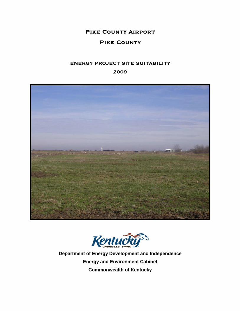
Cover photo (2007) - Proposed development site
The Pike County government has a demonstrated interest in evaluating the Pike County
Airport property as a potential energy facility. The development of an energy facility,
whether for coal-to liquid (CTL)/coal-to-gas (CTG), wind, nuclear, solar or biomass,
must consider basic common factors which include access to transportation, general
topography, proximity to public access areas, and available utilities, among other
considerations.
GENERAL SITE CONSIDERATIONS
Ownership
The owners of the proposed site are Buffalo Development, Hatcher Trimble Trust, East
Kentucky Energy, Wayne W. Clark and Clinton Coleman. Mineral is owned by Buffalo
Development, Hatcher Trimble Trust, East Kentucky Energy and Elkhorn Coal
Corporation.
Size
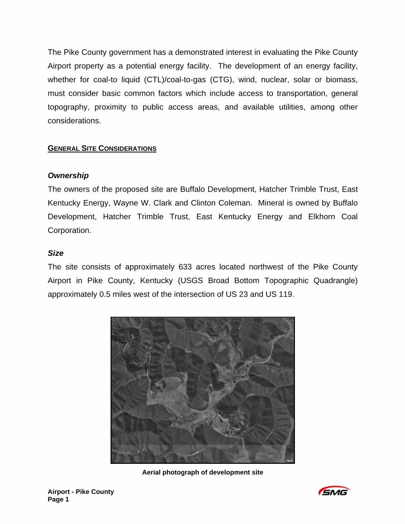
The site consists of approximately 633 acres located northwest of the Pike County
Airport in Pike County, Kentucky (USGS Broad Bottom Topographic Quadrangle)
approximately 0.5 miles west of the intersection of US 23 and US 119.
Aerial photograph of development site
Airport - Pike County Page 1
Topography
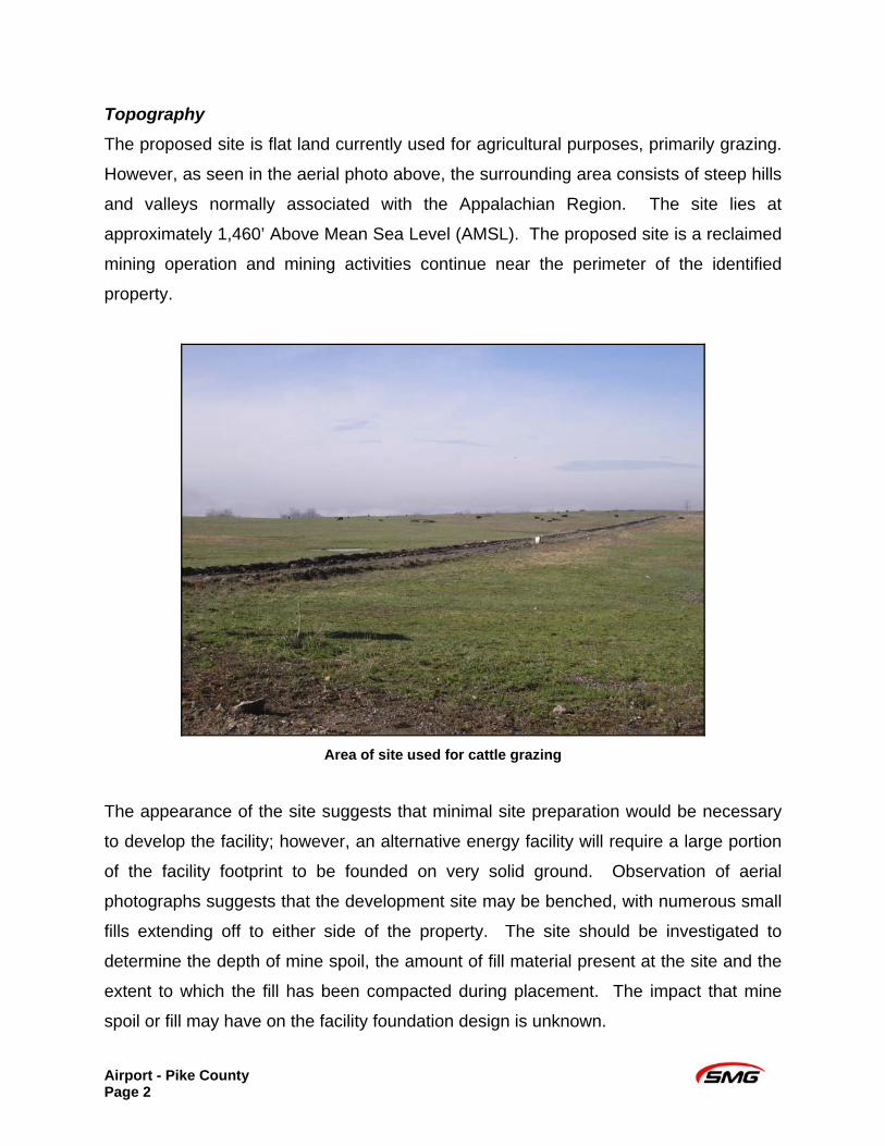
The proposed site is flat land currently used for agricultural purposes, primarily grazing.
However, as seen in the aerial photo above, the surrounding area consists of steep hills
and valleys normally associated with the Appalachian Region. The site lies at
approximately 1,460’ Above Mean Sea Level (AMSL). The proposed site is a reclaimed
mining operation and mining activities continue near the perimeter of the identified
property.
Area of site used for cattle grazing
The appearance of the site suggests that minimal site preparation would be necessary
to develop the facility; however, an alternative energy facility will require a large portion
of the facility footprint to be founded on very solid ground. Observation of aerial
photographs suggests that the development site may be benched, with numerous small
fills extending off to either side of the property. The site should be investigated to
determine the depth of mine spoil, the amount of fill material present at the site and the
extent to which the fill has been compacted during placement. The impact that mine
spoil or fill may have on the facility foundation design is unknown.
Airport - Pike County Page 2
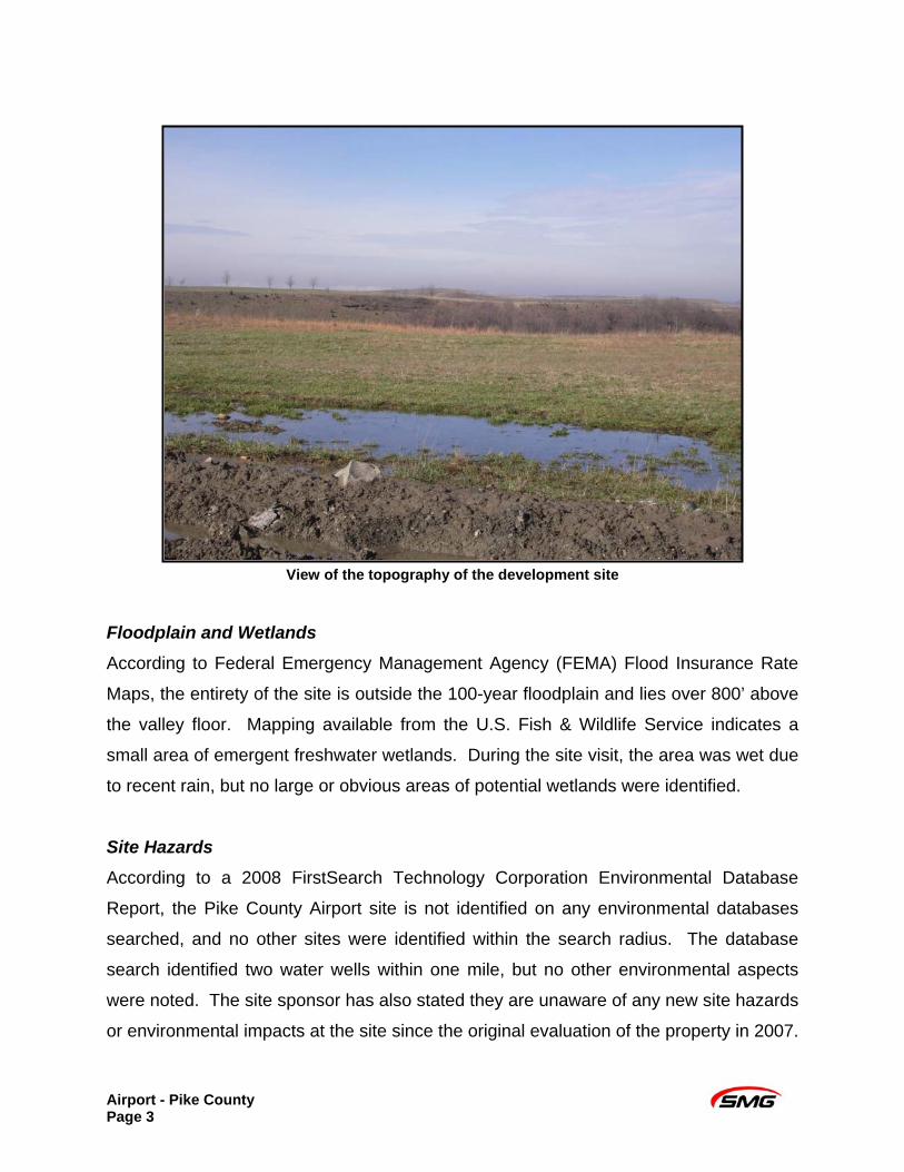
View of the topography of the development site
Floodplain and Wetlands
According to Federal Emergency Management Agency (FEMA) Flood Insurance Rate
Maps, the entirety of the site is outside the 100-year floodplain and lies over 800’ above
the valley floor. Mapping available from the U.S. Fish & Wildlife Service indicates a
small area of emergent freshwater wetlands. During the site visit, the area was wet due
to recent rain, but no large or obvious areas of potential wetlands were identified.
Site Hazards According to a 2008 FirstSearch Technology Corporation Environmental Database
Report, the Pike County Airport site is not identified on any environmental databases
searched, and no other sites were identified within the search radius. The database
search identified two water wells within one mile, but no other environmental aspects
were noted. The site sponsor has also stated they are unaware of any new site hazards
or environmental impacts at the site since the original evaluation of the property in 2007.
Airport - Pike County Page 3
There are also no landfills on the site or adjacent to it. No identified state, county, or
municipal zoning restrictions apply to the area.
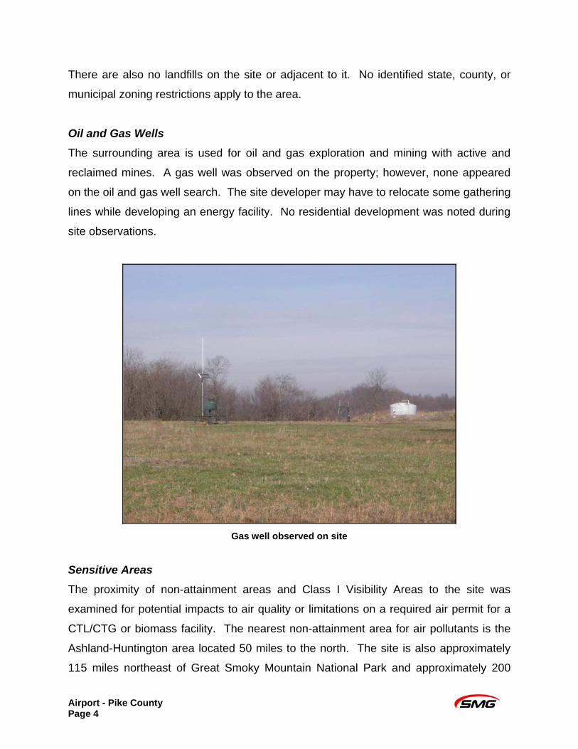
Oil and Gas Wells
The surrounding area is used for oil and gas exploration and mining with active and
reclaimed mines. A gas well was observed on the property; however, none appeared
on the oil and gas well search. The site developer may have to relocate some gathering
lines while developing an energy facility. No residential development was noted during
site observations.
Gas well observed on site
Sensitive Areas
The proximity of non-attainment areas and Class I Visibility Areas to the site was
examined for potential impacts to air quality or limitations on a required air permit for a
CTL/CTG or biomass facility. The nearest non-attainment area for air pollutants is the
Ashland-Huntington area located 50 miles to the north. The site is also approximately
115 miles northeast of Great Smoky Mountain National Park and approximately 200
Airport - Pike County Page 4
miles east of Mammoth Cave National Park, the two Class I Visibility Areas closest to
the site.
State water data was searched to determine if designated impaired streams in the area
might affect discharge requirements for an energy facility. Location of the proposed site
is 3.5 miles away from Levisa Fork which would ultimately be the receiving stream for
drainage from the site. Levisa Fork from mile point 116.0 to 124.4 is on the 2008
303(d) List of Surface Waters for impaired uses of aquatic life and primary contact
recreation because of sedimentation/siltation and pathogens. The use designations for
the Levisa Fork in accordance with 401 Kentucky Administrative Regulations (KAR)
10:026 are warm water aquatic habitat, primary contact recreation, secondary contact
recreation, and drinking water source. There are no public water intakes within 15 miles
downstream of the site.
Siting considerations for any energy facility include the presence of Threatened and
Endangered (T&E) species in the area, the presence of significant cultural or historical
resources in and around the project area, and proximity to public access areas and
airports. The nearest public access area is Fishtrap Lake located approximately 12
miles to the southeast of the site. No other public access areas, such as trails or nature
preserves were identified in the area. The site is adjacent to the existing Pike County
Airport, but the runway runs east-to-west and is not expected to interfere with site
development. However, the height and activity of required equipment for CTL/CTG or
an alternative energy facility can present a hazard to air traffic; thus, further
investigation may be required prior to development.
Listings for National Register Properties, National Register Districts, and Inventoried
(potentially eligible) Sites were reviewed and no historic, eligible or potentially eligible
sites were identified at or within 100 meters of the project area.
The Northern Harrier has been documented on the Broad Bottom topographic map and
is listed as threatened by Kentucky Fish & Wildlife (F&W). However, the preferred
Airport - Pike County Page 5
habitat of the Northern Harrier includes bodies of water and wetlands which are not
likely to occur since the subject site is a high plateau created by mining reclamation.
Additional investigation may be required to characterize and determine or mitigate the
impact of development on sensitive areas near the site.
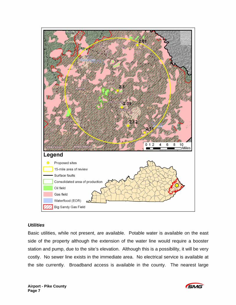
Geological Assets
Siting considerations for a biomass or CTL/CTG process must take into account
available geological assets for potential sequestration. The graphic below was
prepared by the Kentucky Geologic Survey (KGS) to illustrate the site’s assets with
regard to oil and gas production and surface faults. The site is identified as 2.1 on the
map. Geologic assets of the site are moderate to good.
The proximity of faults to a site may impact the development of a nuclear, biomass, or
CTL/CTG facility. Based on mapping from the KGS, the seismic risk at the proposed
site is quite low.
Airport - Pike County Page 6
Utilities
Basic utilities, while not present, are available. Potable water is available on the east
side of the property although the extension of the water line would require a booster
station and pump, due to the site’s elevation. Although this is a possibility, it will be very
costly. No sewer line exists in the immediate area. No electrical service is available at
the site currently. Broadband access is available in the county. The nearest large
Airport - Pike County Page 7
natural gas transmission line appear to be a Columbia Gas Transmission Corporation
(CGT-TCO) line, located within 15 miles.
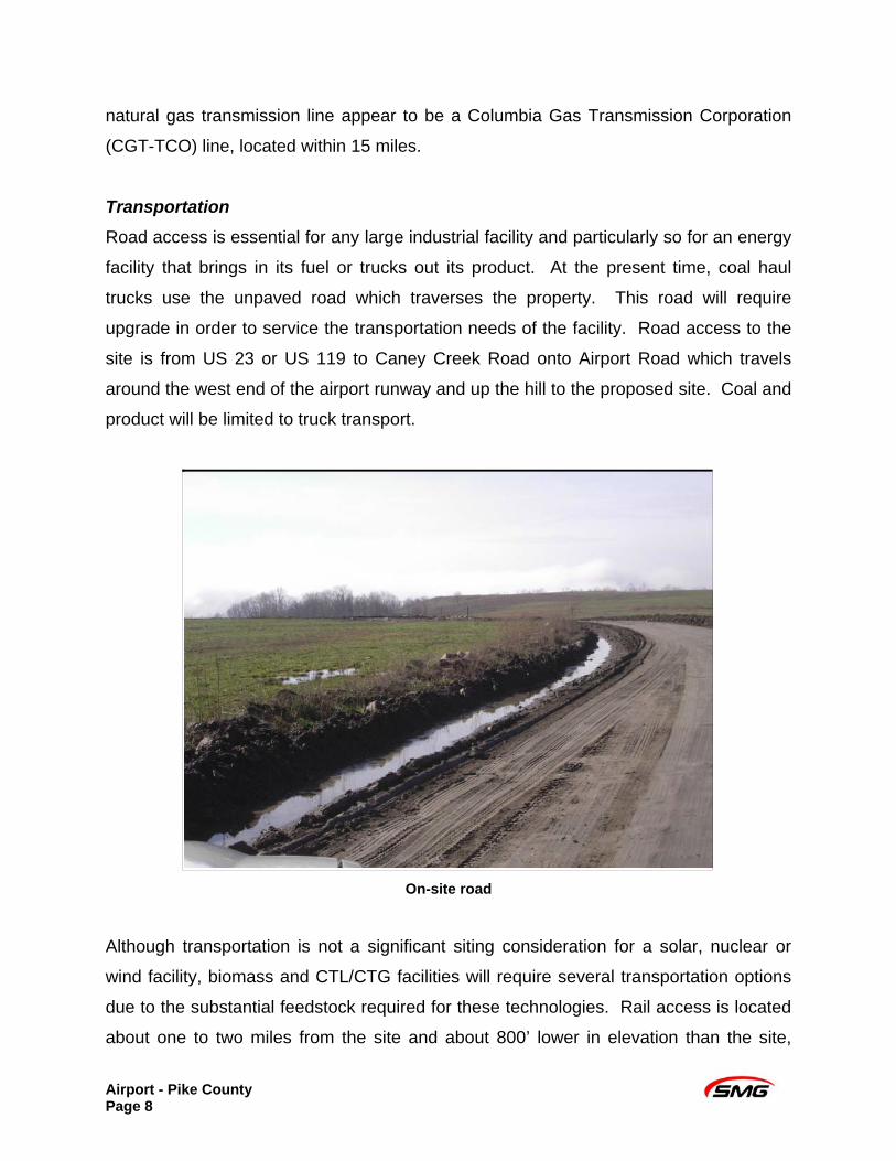
Transportation
Road access is essential for any large industrial facility and particularly so for an energy
facility that brings in its fuel or trucks out its product. At the present time, coal haul
trucks use the unpaved road which traverses the property. This road will require
upgrade in order to service the transportation needs of the facility. Road access to the
site is from US 23 or US 119 to Caney Creek Road onto Airport Road which travels
around the west end of the airport runway and up the hill to the proposed site. Coal and
product will be limited to truck transport.
On-site road
Although transportation is not a significant siting consideration for a solar, nuclear or
wind facility, biomass and CTL/CTG facilities will require several transportation options
due to the substantial feedstock required for these technologies. Rail access is located
about one to two miles from the site and about 800’ lower in elevation than the site,
Airport - Pike County Page 8
increasing the costs of transporting feed stock in to a facility and products out. Coal or
other materials would have to be belted or trucked from the track up to the development
site. No barge transport is available in the area as there are no navigable waters in this
part of Kentucky.
Transmission
Any energy facility will require access to electric transmission points. A 69kV line
should be an adequate capacity to carry generated power from a solar facility in
Kentucky. A nuclear, biomass, wind or CTL/CTG facility would require access to larger
electric transmission points. A 34kv line is located one mile east of the site and a 138kv
line is located 3 miles west of the site. No appropriate right of way to the site has been
identified. Consultation with American Electric Power (AEP), the utility supplying
service to this area, would be required to determine how the site will be able to access
high voltage lines.
Natural gas is used as a feedstock and fuel in CTL/CTG and for some biomass facilities,
making access to a supply important. Additionally, if the facility makes synthetic natural
gas, access to a transmission pipeline will be important in getting products to market.
Location of the nearest large gas transmission line should be confirmed although it
appears that a CGT-TCO line is located within 15 miles.
Water Supply
Available water supply is a critical project component for the development of a
CTL/CTG, biomass or nuclear facility. The location of the proposed site is 3.5 miles
away from the Levisa Fork. The Levisa Fork is part of the Little and Big Sandy River
Basin and its HUC 11 listing is 05070203110. The nearest USGS station is station
03209500 at Pikeville, KY. The lowest mean annual flow at the station is 337 million
gallons per day (MGD) or 234,028 gallons per minute (gpm). The low-flow 7Q10 is 66
MGD (44,444 gpm) and the low-flow 7Q2 is 115 MGD (79,861 gpm) for the Levisa Fork
at station 03209500. The low-flow 7Q10 is the lowest mean flow during seven
consecutive days over a ten-year period. The low-flow 7Q2 is the lowest mean flow
Airport - Pike County Page 9

during seven consecutive days over a two year period. There are no public water
intakes within 5 miles downstream of the site.
Typically, a CTL/CTG or biomass facility require a minimum of 2,500 gpm or 3.6 MGD
for process or cooling water needs, and a nuclear facility requires a minimum of 8,000
gpm or 11.5 MGD for cooling water needs. Although Levisa Fork would be an adequate
supply to support the cooling water needs for a biomass, CTL/CTG or nuclear facility,
due to distance and elevation, the cost of pumping and piping water to the site from the
stream, would require significant capital and be economically infeasible. No other
potentially viable water resources were reported in proximity to the site during this
evaluation.
Workforce Availability
Development of a CTL/CTG, biomass, or nuclear facility would require access to an
adequate supply of construction and skilled labor. The labor market is identified by the
Cabinet for Economic Development as consisting of the five Kentucky counties
surrounding Pike County and includes Mingo County in West Virginia. Total labor
available in this area is estimated to be about 76,000. In reality, the labor market
probably extends further into the next tier of counties and additional labor from these
counties could swell the labor market to in excess of 100,000.
Airport - Pike County Page 10
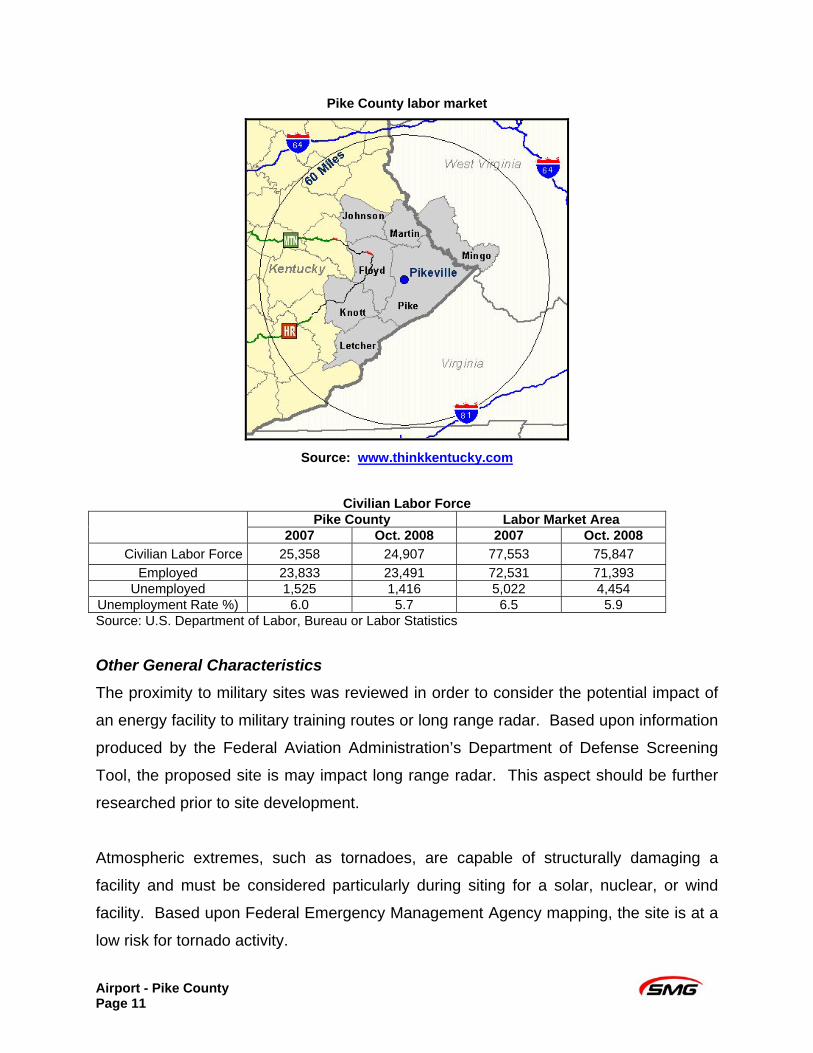
Pike County labor market
Source: www.thinkkentucky.com
Civilian Labor Force
Pike County Labor Market Area 2007 Oct. 2008 2007 Oct. 2008
Civilian Labor Force 25,358 24,907 77,553 75,847 Employed 23,833 23,491 72,531 71,393
Unemployed 1,525 1,416 5,022 4,454 Unemployment Rate %) 6.0 5.7 6.5 5.9 Source: U.S. Department of Labor, Bureau or Labor Statistics
Other General Characteristics The proximity to military sites was reviewed in order to consider the potential impact of
an energy facility to military training routes or long range radar. Based upon information
produced by the Federal Aviation Administration’s Department of Defense Screening
Tool, the proposed site is may impact long range radar. This aspect should be further
researched prior to site development.
Atmospheric extremes, such as tornadoes, are capable of structurally damaging a
facility and must be considered particularly during siting for a solar, nuclear, or wind
facility. Based upon Federal Emergency Management Agency mapping, the site is at a
low risk for tornado activity.
Airport - Pike County Page 11
TECHNOLOGY SPECIFIC CONSIDERATIONS CTL/CTG
In addition to the common factors described above for energy site development, unique
factors specific to a particular technology must be considered. For a CTL/CTG facility,
access to coal resources is important. For this proposed site, coal resources are
adequate, although transportation would be limited to road until rail access is developed
or cross-county conveyor belting is established. The eastern Kentucky coal field covers
approximately 10,500 square miles and contains approximately 51.9 billion tons of
remaining resources. Pike County has an annual production of approximately 26 million
tons per year. One hundred and fifty five (155) operators were licensed in Pike County
in 2006, making it one of the most productive markets in the state. The viability for
CTL/CTG on this site is limited due to the location adjacent to an airport. The height
and activity of the required equipment could present a hazard to low level flight paths for
landings and take offs.
Solar
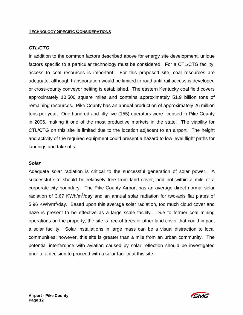
Adequate solar radiation is critical to the successful generation of solar power. A
successful site should be relatively free from land cover, and not within a mile of a
corporate city boundary. The Pike County Airport has an average direct normal solar
radiation of 3.67 KWh/m2/day and an annual solar radiation for two-axis flat plates of
5.96 KWh/m2/day. Based upon this average solar radiation, too much cloud cover and
haze is present to be effective as a large scale facility. Due to former coal mining
operations on the property, the site is free of trees or other land cover that could impact
a solar facility. Solar installations in large mass can be a visual distraction to local
communities; however, this site is greater than a mile from an urban community. The
potential interference with aviation caused by solar reflection should be investigated
prior to a decision to proceed with a solar facility at this site.
Airport - Pike County Page 12
Solar insolation map
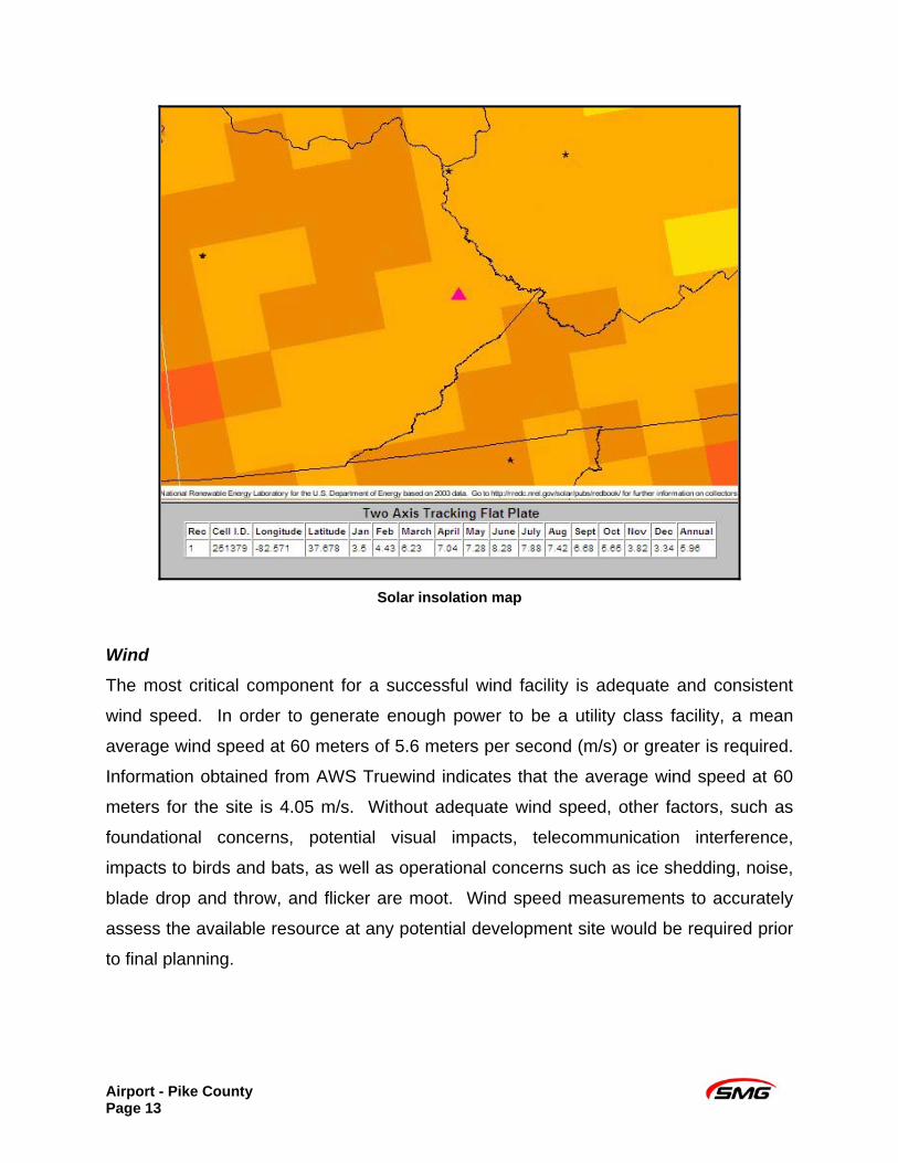
Wind The most critical component for a successful wind facility is adequate and consistent
wind speed. In order to generate enough power to be a utility class facility, a mean
average wind speed at 60 meters of 5.6 meters per second (m/s) or greater is required.
Information obtained from AWS Truewind indicates that the average wind speed at 60
meters for the site is 4.05 m/s. Without adequate wind speed, other factors, such as
foundational concerns, potential visual impacts, telecommunication interference,
impacts to birds and bats, as well as operational concerns such as ice shedding, noise,
blade drop and throw, and flicker are moot. Wind speed measurements to accurately
assess the available resource at any potential development site would be required prior
to final planning.
Airport - Pike County Page 13
Mean Wind Speed – 4.05 m/s
Biomass An adequate feedstock supply environment includes available crop residues, animal
manure, forest residues from former silviculture or clearing, primary and secondary mill
residues, urban residues (i.e., wood scraps from local business such as lumberyards),
landfill gas, domestic wastewater, or switchgrass. Information obtained from the
National Renewable Energy Laboratory indicates that the total biomass available within
Pike County is 72,671 tonnes/year. Biomass in Pike and its surrounding Counties is
276,394 tonnes/year. Due to limited feedstock variability, depending on the type of
feedstock utilized, these supplies (< 500,000 tonnes/year) may not provide adequate
feedstock; further investigation would be required. Pike County has lower biomass
availability in comparison to other locations throughout Kentucky. Analysis of the
potential in the area to grow feedstock specifically for a biomass facility should also be
part of the planning process.
Airport - Pike County Page 14
Airport - Pike County Page 15
Nuclear
A limiting factor to the development of a nuclear facility is an available water supply.
There are no water resources on the site that are sufficient for supplying the minimal
11.5 MGD of water required to meet basic cooling water needs for a nuclear facility.
Although the nearest considerable water resource, Levisa Fork, would be an adequate
supply of water for nuclear operations, distance and elevation from the site to the
stream make this an economically infeasible supply. Due to this infeasibility, other
factors, such as safety issues, proximity to population centers and atmospheric
conditions are moot.
SUITABILITY
In summary, the Pike County Airport site, located within the Eastern Kentucky Coal
Fields, has very limited viability for the energy technologies reviewed. The proposed
site suffers from its lack of utilities and resources including transportation options,
electricity, and labor force
The forms of alternative energy evaluated in this report have limited potential for the
Pike County Airport site. Due to a low average mean wind speed, this location is not a
viable location for a utility scale wind facility. Available solar radiation at the site is too
low to produce a significant source of energy for a utility solar facility alone, with a site
score of 391 points, representing 42% of the total available points. Reflection from the
solar panels could interfere with takeoff and landing patterns of aircraft at the adjacent
airport. Additionally, this site would also not be suitable for a nuclear, CTL/CTG, or
biomass facility due to the cost of pumping and piping water to the site. The percentage
of total available points scored for nuclear, CTL/CTG, and biomass are 0%, 61%, and
62%, respectively.

Kentucky Department for Energy Development and Independence http://www.energy.ky.gov/
500 Metro Street 12th Floor, Capital Plaza Tower
Frankfort, KY 40601 (502) 564-7192 or (800) 282-0868
Smith Management Group www.smithmanage.com
1405 Mercer Road Lexington, KY 40511
(859) 213-8936
Pike County Fiscal Court c/o Roger Ford 146 Main Street
Pikeville, KY 41501


