20
Pilot implementation of Identifiers using URIs and own URI service Tuuli Pihlajamaa INSPIRE Conference 2016 / 26 Sep. 2016

Pilot implementation of Identifiers using
URIs and own URI service
Tuuli Pihlajamaa
INSPIRE Conference 2016 / 26 Sep. 2016

Terms used in presentation
- URI’s: “A Uniform Resource Identifier (URI) is a compact sequence of characters
that identifies an abstract or physical resource.” (https://tools.ietf.org/html/rfc3986)
- URI service: data provider’s URI service
- RDF: Resource Description Framework, “One of the key ingredients of Linked
Data, and provides a generic graph-based data model for describing things,
including their relationships with other things.“ (http://linkeddata.org/faq)
- Turtle - Terse RDF Triple Language: “Turtle is a plain text format for serializing
RDF data.” (http://linkeddatabook.com/editions/1.0/#htoc17)
- SPARQL: query language for RDF
- JHS 193: ”JHS 193 Unique identifiers of the geographic information”, a national
recommendation for Public Administration in Finland
4 October 2016 Tuuli Pihlajamaa2

Background for the pilot
- INSPIRE Generic Conceptual Model, Annex H, Implementation of Identifiers using URIs
in INSPIRE:
“The INSPIRE Directive, in Art. 8(2), requires the adoption of a common framework for the
unique identification of spatial objects to support interoperability of spatial data across Europe.
---The Directive requires that identifiers under national systems can be mapped to that common
framework.”
- Guidelines for the encoding of spatial data, Annex C, Recource identifiers:
• Recommendation 12 Identifiers of resources should be URIs in the “http” scheme.
• Recommendation 13 While it is not strictly a requirement that the resource can be accessed via the
HTTP protocol using its http URI, it is strongly recommended that this is the case.
• Recommendation 15 URIs of spatial objects should be persistent http URIs and include the
namespace and the local identifier part of the INSPIRE identifier, if available.
- In Finland there is centralized dereferencing service
• Hosted by National Land Survey of Finland
• URI’s for real-world phenomena /id/, spatial objects /so/, definitions /def/ and documentation /doc/
• URI’s for spatial objects (INSPIRE and other)
• Data providers determine local-ID’s of inspire-ID’s / URI’s for so’s and (id’s)
• Requests to URI’s -> data provider’s own URI service
• URI service of the data provider will return the documentation related to the spatial object, in requested
format
4 October 2016 Tuuli Pihlajamaa3

Statistics Finland’s INSPIRE services and
data
- View services (WMS) and download services (WFS and ATOM-feed) are available since May
2013 (http://www.stat.fi/tup/rajapintapalvelut/inspire_aineistot_en.html)
- Annex III
- Statistical Units:
• Municipality-based statistical units
• Grid net for statistics 1 km x 1 km
- Population Distribution:
Population by municipality-based units
Population grid data 1 km x 1 km
- Production and industrial facilities:
Production and industrial facilities
- Utility and governmental services:
Educational institutions
- Data is not yet harmonized to INSPIRE data schemas
4 October 2016 Tuuli Pihlajamaa4

Aim of the pilot
1. Example with the unique identifiers of geographic information(finding data, machine readability)
2. Forming unique identifiers of geographic information(based on the data source)
3. Input for harmonizing spatial data to INSPIRE schema(understanding TG’s)
4. Steps towards Linked data
Both http URI’s of spatial objects (so) and own URI service are piloted(sample data municipalities, LAU2)
Requests to /so/-URI’s in own URI service will be dereferenced (WFS-
service, RDF-server)
Pilot will be done in intranet (Later dereferencing from domain paikkatiedot.fi)
4 October 2016 Tuuli Pihlajamaa5

Tasks in the pilot
A) Creating pilot URI’s for INSPIRE- spatial objects (so)
- Example URI’s for each spatial object (a municipality) of certain time, here year 2014.
- In JHS 193 is given recommendations about URI’s:
• URI’s for INSPIRE-harmonized data:
http://paikkatiedot.fi/so/resourceIdentifier/theme/class/localid/(versionid)
- In the pilot there won’t be created new localid’s in database, since the localid’s will be
generated from the information already provided in GML data.
- URI’s in the pilot are examples. Final URI’s will be decided, when the INSPIRE data
products are defined and there are life-cycle rules defined for them.
B) Building URI service in intranet
- Based in technical description and examples provided in JHS 193 appendix 2.
• Establishing of Geoserver and sample data
• Establishing Apache server and creating redirecting rules in .htaccess-file
• Establishing of Jena Fuseki server
• Creating xslt-transformation file
• Uploading Turtle-format result to Jena Fuseki.
4 October 2016 Tuuli Pihlajamaa6
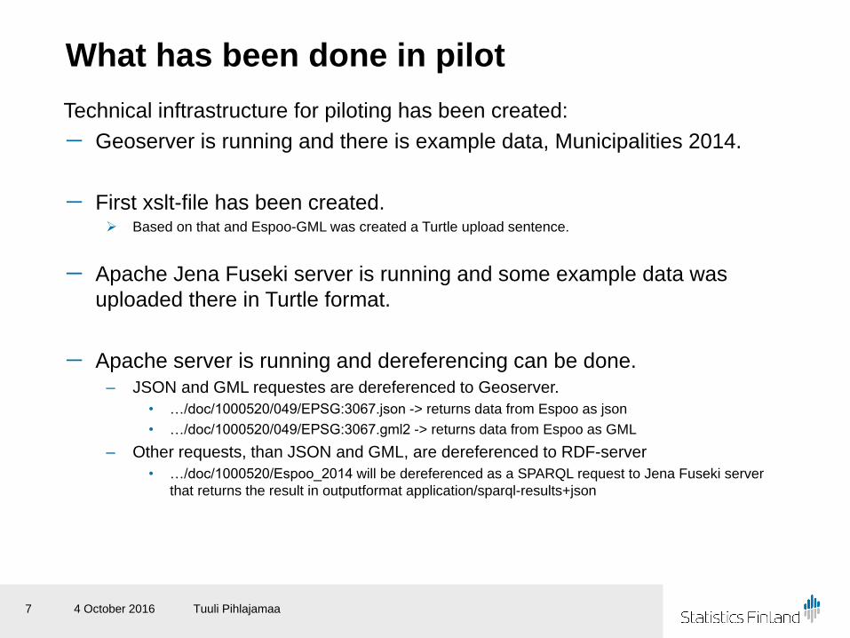
What has been done in pilot
Technical inftrastructure for piloting has been created:
- Geoserver is running and there is example data, Municipalities 2014.
- First xslt-file has been created. Based on that and Espoo-GML was created a Turtle upload sentence.
- Apache Jena Fuseki server is running and some example data was
uploaded there in Turtle format.
- Apache server is running and dereferencing can be done.– JSON and GML requestes are dereferenced to Geoserver.
• …/doc/1000520/049/EPSG:3067.json -> returns data from Espoo as json
• …/doc/1000520/049/EPSG:3067.gml2 -> returns data from Espoo as GML
– Other requests, than JSON and GML, are dereferenced to RDF-server
• …/doc/1000520/Espoo_2014 will be dereferenced as a SPARQL request to Jena Fuseki server
that returns the result in outputformat application/sparql-results+json
4 October 2016 Tuuli Pihlajamaa7

Xslt-file for generating Turtle
4 October 2016 Tuuli Pihlajamaa8

Espoo-GML- with reference to xslt-file
4 October 2016 Tuuli Pihlajamaa9

RDF in Turtle-format to be uploaded in Jena
Fuseki:
4 October 2016 Tuuli Pihlajamaa10
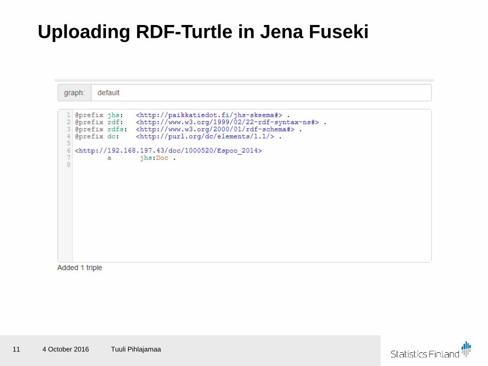
Uploading RDF-Turtle in Jena Fuseki
4 October 2016 Tuuli Pihlajamaa11

SPARQL query
4 October 2016 Tuuli Pihlajamaa12
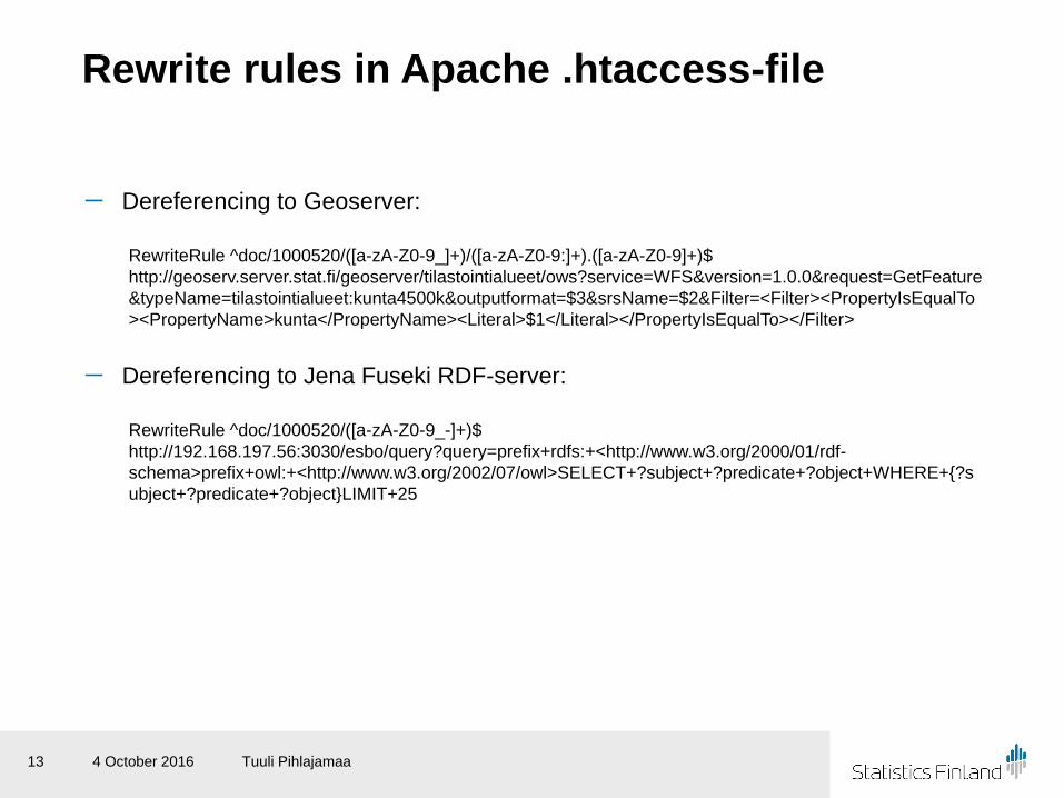
Rewrite rules in Apache .htaccess-file
- Dereferencing to Geoserver:
RewriteRule ^doc/1000520/([a-zA-Z0-9_]+)/([a-zA-Z0-9:]+).([a-zA-Z0-9]+)$
http://geoserv.server.stat.fi/geoserver/tilastointialueet/ows?service=WFS&version=1.0.0&request=GetFeature
&typeName=tilastointialueet:kunta4500k&outputformat=$3&srsName=$2&Filter=<Filter><PropertyIsEqualTo
><PropertyName>kunta</PropertyName><Literal>$1</Literal></PropertyIsEqualTo></Filter>
- Dereferencing to Jena Fuseki RDF-server:
RewriteRule ^doc/1000520/([a-zA-Z0-9_-]+)$
http://192.168.197.56:3030/esbo/query?query=prefix+rdfs:+<http://www.w3.org/2000/01/rdf-
schema>prefix+owl:+<http://www.w3.org/2002/07/owl>SELECT+?subject+?predicate+?object+WHERE+{?s
ubject+?predicate+?object}LIMIT+25
4 October 2016 Tuuli Pihlajamaa13
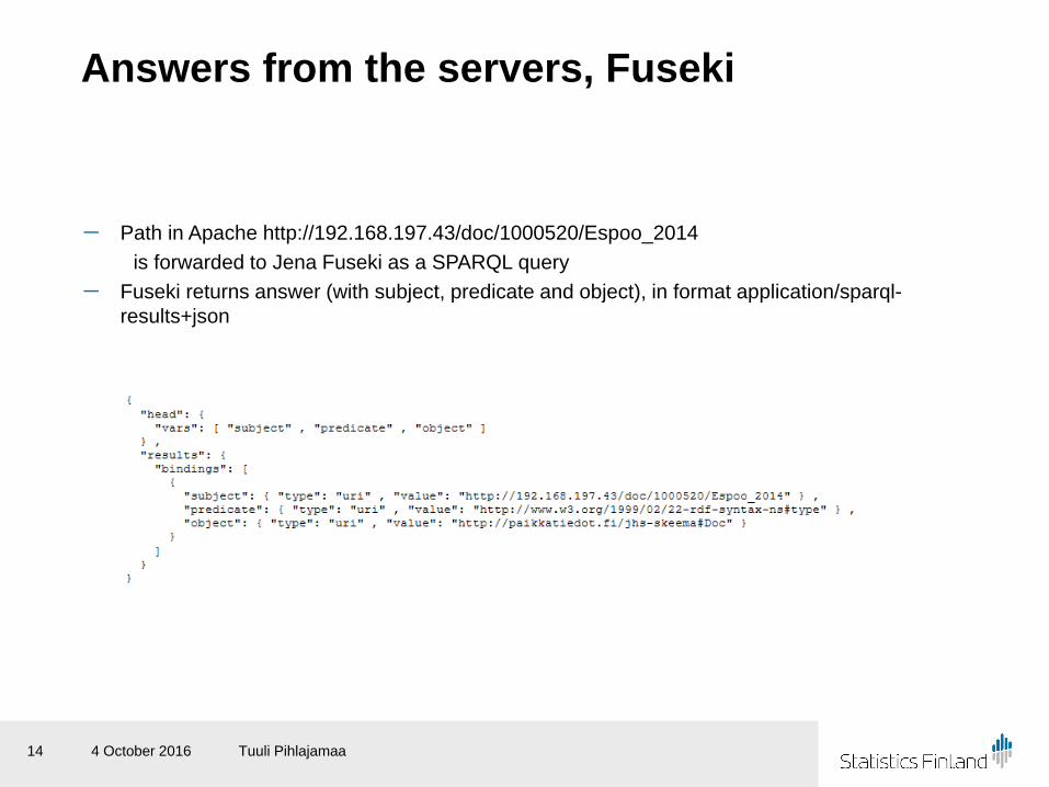
Answers from the servers, Fuseki
- Path in Apache http://192.168.197.43/doc/1000520/Espoo_2014
is forwarded to Jena Fuseki as a SPARQL query
- Fuseki returns answer (with subject, predicate and object), in format application/sparql-
results+json
4 October 2016 Tuuli Pihlajamaa14

Answers from the servers, GML
4 October 2016 Tuuli Pihlajamaa15
-Path in Apache http://192.168.197.43/doc/1000520/049/EPSG:3067.gml2 gives the answer in GML-format
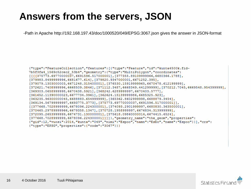
Answers from the servers, JSON
4 October 2016 Tuuli Pihlajamaa16
-Path in Apache http://192.168.197.43/doc/1000520/049/EPSG:3067.json gives the answer in JSON-format

Next steps in pilot
1. Transformation file needs to be fixed– Despite of using encoding UTF-8 in the GML-data, there was a problem with the Turtle transformation
when there were Scandinavian letters (å, ä, ö) in the source data.
2. After that, transformation could be done online in transformation service,
utilizing data directly from Geoserver.
3. Pilot URI’s need to be tested more– Espoo_2014 works fine since the name and year can be picked from the data.
– But how to pick only part on the string from the data (for example year from validityPeriod)
4. Enriching the RDF data needs to be done– For example adding INSPIRE code list for onthology
5. Fixing the rewrite rules– Instead of using QUERY, could be used CONSTRUCT, to give the result in RDF graph format
4 October 2016 Tuuli Pihlajamaa17
Conclusions
Input for INSPIRE work:
- Piloting has helped to see both challenges and benefits of harmonizing
data into INSPIRE schema.
- It has helped to ask relevant questions
E.g. questions regarding the URI’s and the data has helped to
understand better the Technical Guidelines.
Input for statistics:
- Http URI’s and own URI service for geographical data can be utilised
when creating Linked data solutions for statistics in wider aspect
- Created solution can also function as an example of unique identifiers for
statistics.
4 October 2016 Tuuli Pihlajamaa18
Useful links
- INSPIRE Generic Conceptual Model:
http://inspire.ec.europa.eu/documents/Data_Specifications/D2.5_v3.
4.pdf
- Guidelines for the encoding of spatial data:
http://inspire.ec.europa.eu/documents/Data_Specifications/D2.7_v3.
3.pdf
- JHS Recommendation 193 (in Finnish):
http://www.jhs-suositukset.fi/web/guest/jhs/recommendations/193/full
4 October 2016 Tuuli Pihlajamaa19


