20
December 2013 Attachment B PIPELINE ALIGNMENT OPTIONS ASSESSMENT Extract from Concept Design Review Report
December 2013
Attachment B
PIPELINE ALIGNMENT OPTIONS ASSESSMENT
Extract from Concept Design Review Report

December 2013
Attachment B
Water for a Growing West Options Assessment

December 2013 B-1
Melbourne Water (MW) has engaged Kellogg Brown & Root Pty Ltd (KBR) to undertake route selection and review of the concept design of a water supply pipeline from near St Albans Reservoir to the Cowies Hill Reservoir, referred to as the ‘Water for a Growing West’ project.
A Concept Design Review Report (MEG302-0001-TD-OT-REP-0003) was prepared, which included an options assessment to determine Melbourne Water’s preferred pipeline alignment. The following is an extract of this report.
BACKGROUND TO OPTIONS ASSESSMENT
A preferred corridor had been selected by Melbourne Water based on the outcome of the preliminary investigations, which is referred to as “Base Case” in this report.
The Base Case alignment corridor utilised existing power easement and road reserves of Robinsons, Christies and Tarneit Roads.
It crosses major road and rail infrastructure in the Ballarat Road, Melbourne-Ballarat rail corridor, Deer Park Bypass and Regional Rail Link (RRL). In order to reduce the number of potential bored crossings for this project, three concrete pipe sleeves have been installed at nominated crossing locations on the RRL. A pipe sleeve had been previously installed beneath Deer Park Bypass, immediately south of the Ballarat railway underpass.
APPROACH
The following tasks were undertaken in completing the options assessment:
• Review of all existing information including a gap assessment report and its addenda;
• Review of concept alignment proposed by Melbourne Water;
• Key stakeholder consultation;
• Development of alternative alignments based on new information and stakeholder consultation;
• Screening and short listing of alignment options;
• Preparation of comparative cost estimates for the shortlisted options;
• Undertake a Multi Criteria Analysis (MCA) of the shortlisted options.
The MCA was completed having regard to the methodology described in Melbourne Water’s Triple Bottom Line Guidelines—A guide to sustainable decision making, November 2011, the Melbourne Water TBL-MCA Model User Manual, December 2008 and Department of Treasury and Finances scoring approach relative to a base case.
PROJECT AREA OVERVIEW
This section provides an overview of the project area with regards to the environmental, heritage, geological, topographical and land use characteristics of the project area, each form critical aspects of the identification of a preferred route alignment.
Biodiversity Values
The WGW project area is within the Victorian Volcanic Plain bioregion, which is vegetated mainly by native grasses and woodlands with many natural wetlands (DSE 2003). The project area has largely been cleared of native vegetation; however scattered remnant patches of native vegetation remain amongst a developed and agricultural landscape. The project area also contains known locations and potential habitat for several significant flora and fauna species.

December 2013 B-2
Aboriginal and post-contact heritage
Previously recorded sites listed on the Victorian Aboriginal Heritage Register have been identified within the project area (Melbourne Water 2013a). These sites have been identified in the St Albans, Deer Park, Ravenhall and Tarneit sections of the project area.
One post-contact heritage site was identified in the project area, the Victorian Heritage inventory site, Ravenhall Magazine and Storage Facility (H7822-0174) (see B-3-1) (Biosis Research 2012a).
Topography
The region between St Albans and Cowies Hill, Tarneit is relatively flat, with a fall in elevation from St Albans (68m AHD) to Cowies Hill (43m AHD). There is also a small hill midway along the alignment along Middle Road (62m AHD).
Geology
The project area is located on the Undulating Plains - Western District geomorphic unit (DSE 2013). The area between St Albans and Cowies Hill is dominated by newer volcanic basalt with minor sections of Quarternary sedimentary deposits and Devonian granite. A site walk of the area revealed large fissures in the soil surface for the majority of the route length; a recently constructed bicycle path alongside Deer Park Bypass exhibited substantial damage due to ground movement associated with the presence of the highly reactive soils. It is assumed that the soil is of a reactive nature; however this is to be confirmed by the detailed geotechnical investigation. Generally, the project area soils are considered moderately to rapidly drained (DSE 2013).
Hydrology
The project area is located within the Werribee catchment which covers an area of approximately 2700 square kilometres and is characterised by low rainfall and hence low stream flow (Melbourne Water 2007). The project area is intersected by three waterways, the major waterway crossing being Kororoit Creek (a permanent waterway) and two minor crossings being Skeleton Creek and Dry Creek and their tributaries (both ephemeral waterways) (Melbourne Water 2013b). Dry Creek is a tributary of Skeleton Creek (Melbourne Water 2013b).
Land Use
The project area occurs across a variety of land uses and council boundaries, which includes residential and industrial uses, grazing and cropping, road and power reserves and easements, and a prison precinct. Approximately half of the alignment generally from Ravenhall to Tarneit is not yet developed for residential or business use however urban growth and development is occurring steadily within the region. The project area traverses Brimbank, Melton and Wyndham City Council jurisdictions.
The project area is partly located in urban growth areas which are designated for urban use and are further defined through the development of precinct structure plans (PSP). These PSPs act as the main planning tool to determine the character and make-up of new communities within the MSA (GAA 2013) and are developed and implemented through a planning scheme amendment. The project area occurs within the Wyndham Growth Area where PSPs (PSP28, 29, 1087, 1089 and 1090) apply. These are either being developed or have been approved.
A number of major infrastructure projects are currently underway or are in planning phase. These include the Regional Rail Link, Robinsons Road upgrade, the potential future Western Intermodal Freight Terminal (WIFT) and proposed East-West link arterial along Middle Road.

December 2013 B-3
The Boral Quarry covers a large area of land in the middle portion of the project area and is the key reason the pipeline deviates from the power easement between Melbourne-Ballarat rail corridor and Middle Road. Boral is looking to extend the site north towards the Melbourne-Ballarat rail corridor under its current license.
POTENTIAL ALIGNMENT CORRIDORS
As a result of new information provided by the stakeholders regarding the Base Case alignment, KBR identified a number of alternate route options for sections of the alignment. These were then subject to further investigation and evaluation.
For the purpose of options assessment, the proposed pipeline was segmented into four sections: A, B, C and D. These sections are described in Table 1 below:
Table 1 Alignment Breakdown
Section Boundaries
A Tie-in at Station Road to Robinsons Road
B Power easement at Robinsons Road to Christies Road
C Christies Road to Tarneit Road
D Tarneit Road to tie-in at Cowies Hill
The identified routes for further investigation and comparison are illustrated in Figure 1 and detailed in Table 2. Based on discussions with stakeholders, no reason was found to investigate an alternative route for section A.

kj
kj
kj
kjkj
kj
WYNDHAMCITY COUNCIL
MELTONSHIRE COUNCIL
BRIMBANKCITY COUNCIL
DO
HER
TYS DR
AIN
KO
RO
RO
IT CR
EEK
SKELETO
N C
REEK
DRY CREEK
BALLARAT RAILWAY
ST ALBANSRESERVOIR
COWIES HILLRESERVOIR
BENDIGO RAILWAY
!(D-1 !(D-2
!(C-2
!(C-1
!(A-1
!(B3-1
!(B3-4
!(B3-2
!(B-2
!(B3-3
!(B-1
T
T
PROPOSED 8 LANE INTERSECTION
PROPOSED 4 LANES FOR TARNEIT RD
LEAKES ROAD
WESTERN FREEWAY
MIDDLE ROAD
TAYLORS ROAD
BOUNDARY ROAD
HO
PKIN
S R
OAD
TRO
UPS
RO
AD
DER
RIM
UT
RO
AD
TAR
NE
IT R
OA
D
MT
ATK
INS
ON
RO
AD
PALM
ER
S R
OAD
KIN
GS
RO
AD
FEDERATION TRAIL
GREIGS ROAD
SAYERS ROAD
HUME DRIVE
MAIN ROAD
RO
BIN
SO
NS
RO
AD
WO
OD
S R
OAD
FOLEYS ROAD
RIDING BOUNDARY ROAD
NEALES ROAD
FITZ
GE
RA
LD R
OA
D
MT
DER
RIM
UT
RO
AD
DOHERTYS ROAD
SIN
CLA
IRS
RO
AD
FITZ
GE
RA
LDS
RO
AD
MO
RR
IS R
OA
D
GILLESPIE ROAD
NEALE ROAD
PRIN
CES
FR
EEW
AY
ROCKBANK MIDDLE ROAD
OLD GEELONG ROAD
CALD
ER P
ARK
DRIV
E
CH
RIS
TIES
RO
AD
WESTERN HIGHWAY
DEER STREET
WINDSOR BOULEVARD
BALLARAT ROAD
WE
STW
OO
D D
RIV
E
EMIL
Y S
TREE
TBU
RN
S R
OA
D
WESTERN HIGHWAY
BADEN POWELL DRIVE
GO
UR
LAY
RO
AD
GLADSTONE STREET
FULLER ROAD
DOHERTYS ROAD
TAYLORS ROAD
CH
RIS
TIES
RO
AD
DEER
PARK BYPASS
SAYERS ROAD
TAR
NE
IT R
OA
D
Ravenhall
Laverton North - Bal
Mount Cottrell
Rockbank
Derrimut
Deer Park
Burnside
Truganina
Delahey
Cairnlea
Tarneit
Taylors Hill
Laverton
St Albans
Altona
Hoppers Crossing
Caroline Springs
Kings Park
Tarneit
Albanvale
Rockbank
Keilor Downs
Sydenham Taylors Lakes
Laverton North
Sunshine West
Caroline Springs
Truganina
Tarneit
Altona North
Ardeer
Hillside
LegendStage 1 (underway)
kj Section Break Points
A
B-1
B-2
B-3-1
B-3-2
B-3-3
B-3-4
C-1
C-2
D-1
D-2
Pipeline Sleeves
Watercourse
Railway
Urban Growth Boundary
Ravenhall Grassland Reserve
Future Outer Metro Ring Road
Regional Rail Link Project Area
Public Acquisition Overlay
Cemetery
Dame Phyllis Frost Prison
Future Prison Site
Future Rose Grange Activity Centre
Future Substation
Metropolitan Remand Centre
Western Interstate Freight Terminal (WIFT)
Boral Quary
Melbourne Strategic Assessment Area
LGA Boundary
WATER FOR A GROWING WESTSt Albans to Werribee Main Stage 2
MEG302-G-MAP-001-E
°0 1 20.5
Kilometres

December 2013 B-5
Table 2 Alignment corridor options
Section Section Description Major Crossings
Length (km)
A Station Road to Robinson Road
A-1 (Base Case)
M483 Stage-1 Connection→ SPAusNet Easement Kororoit Creek 2.5
B Robinson Road to Christies Road
B-1 (Base Case)
Robinson Rd → MW Drainage Reserve → Westwood Dr → Fuller Rd → Katherine Dr → Private Land → Bore Ballarat R’way → Bore Western Fwy → SPAusNet Easement → Sleeve RRL → Private Land → Riding Boundary Rd → Ravenhall Grassland Reserve
Ballarat Rd Western Fwy
5.2
B-2 Robinson Rd → Drainage Reserve → Bore Western Fwy / Ballarat R’way → Private Land → Sleeve RRL → Private Land → North of Prison → West of Prison → Middle Rd
Ballarat Rd Western Fwy
6.4
B-3-1 Robinson Rd → Bore Ballarat R’way → Middle Rd Ballarat Rd 5.6
B-3-2 Robinson Rd → Bore Ballarat R’way → Bore Western Fwy → South of Prison → Middle Rd
Ballarat Rd Western Fwy
5.4
B-3-3 Robinson Rd → Bore Ballarat R’way → Bore Western Fwy → East of Prison → South of Prison → Middle Rd
Ballarat Rd Western Fwy
5.6
B-3-4 Robinson Rd → Bore Ballarat R’way → Bore Western Fwy → North Prison → West of Prison → Middle Rd
Ballarat Rd Western Fwy
5.6
C Christies Road to Tarneit Road
C-1 (Base Case)
Sleeve RRL → Middle Rd → SPAusNet Easement 6.4
C-2 Sleeve RRL → Middle Rd → Hopkins Rd → SPAusNet Easement 7.4
D Tarneit Road to W351
D-1 (Base Case)
Tarneit Rd → Private Land → Sleeve RRL → Leakes Rd → Tarneit Rd → Dior Lane → Thwaites Rd → W351 Connection
2.2
D-2 Tarneit Rd → Private Land → Sleeve RRL → Leakes Rd → Penrose Prom → Rec Reserve → W351 Connection
2.3

December 2013 B-6
STAKEHOLDER CONSULTATION
The various alignment options developed have been discussed with the following key stakeholders:
• Brimbank, Wyndham and Melton City Councils;
• VicRoads;
• SPAusNet;
• VicTrack;
• Boral (Landowner);
• RRLA (Regional Rail Link Authority);
• DEPI (Department of Environment and Primary Industries);
• DTPLI—Planning (Department of Transport, Planning and Local Infrastructure);
• DoE (Department of Environment);
• GAA (Growth Area authority, now Metropolitan Planning Authority); and
• Melbourne Water.
A summary of stakeholder consultation outcomes and key issues are outlined as follows:
• Alignment and construction method for pipeline crossing of Kororoit Creek is not yet determined.
• Westwood Drive/Fuller Drive is planned for a future upgrade to a six lane major arterial.
• The recent construction of a major drainage culvert just south of Ballarat railway and east of Deer Park Bypass precludes the option of using the existing pipe sleeve constructed at this location beneath Deer Park Bypass.
• Christies Road is planned for a future upgrade involving widening of the road reserve from 20m to 34-40m on the western side into the Boral Quarry with expansion of up to six lanes. Boral Quarry has an existing asphalt plant in the northeast corner of their site adjacent to Christies Road, and is in the process of obtaining permits to upgrade the plant. RRL will run along the eastern length of Christies Road. Ravenhall Grassland Reserve (RGR) is situated to the east of this rail corridor.
• Any encroachment on the RGR by the pipeline would require the removal of critically endangered native vegetation and habitat within crown land set aside as a conservation reserve under the Crown Land (Reserves) Act 1978 (Ravenhall nature conservation reserve) (Biosis Research 2012b). This land has been set aside for the protection of golden sun moth (Synemon plana) and other biodiversity assets.
• Riding Boundary Road has been earmarked for acquisition by Boral for the purpose of future access to its site between Christies and Hopkins Roads.
• Future widening of Middle Road is planned on the southern side as part of the Precinct Structure Plans (PSP). Melton City Council suggested siting the pipeline in the northern road verge within 5m from the road reserved boundary. An alternate to Middle Road is to locate the pipeline in the Boral Quarry buffer zone along the property’s southern boundary.
• Tarneit Road south of Leakes Road is extensively developed and is highly congested with buried services (gas, water, sewer, electricity and Telstra etc.), presenting constructability difficulties within that corridor.
Specific feedback for each proposed alignment is further discussed in the sections below.

December 2013 B-7
SECTION A ALIGNMENT CORRIDOR
The Base Case alignment corridor within Section A is from tie-in to M483 Stage 1 at Station Road and follows the SPAusNet power easement through to Robinsons Road. This is the shortest and the most direct route in this section.
SPAusNet is generally supportive of this alignment, noting however that the relevant construction permits and approvals for constructing within a high voltage power easement shall be required. Utilizing this existing easement presents many benefits including minimising disruption to local residents and the need for additional land acquisition. Being the shortest possible route and receiving no objection to the alignment from SPAusNet, no reason was found to investigate alternative corridors within this section.
Key Challenges
Kororoit Creek is considered a major environmental and recreational asset within Melbourne’s western region (DPCD 2012). At the location of the alignment, key environmental values are present including; endangered remnant plains grassland EVC, riparian woodland EVC, DSE advisory listed arching flax-lily, geologically significant rocky outcrop formations, Aboriginal artefact scatters and likely growling grass frog habitat. Known growling grass frog populations occur upstream and downstream of the location (Melbourne Water 2013b).
Many of these values are recognised by Melbourne Water, which designated the grassland and rocky escarpment directly adjacent to the Creek as a Site of Biodiversity Significance (SOBS). This registered biosite (#5269: Kororoit escarpments-Deer Park) which is fenced for conservation purposes. A population of tough scurf-pea (Cullen tenax), which is listed as threatened under the Flora and Fauna Guarantee Act 1988, has previously been identified by Melbourne Water and is associated with the rocky escarpment. Environmental works associated with the Melbourne Water Capital Works program are planned for this area in 2014 to further enhance the site.
These values, partnered with an existing sewer main and potential future Melbourne Water environmental works, potentially constrain the available construction corridor width through this location and are important considerations for construction across the waterway. A construction plan will need to consider this potential narrowing of construction corridor.
A separate MCA considering social, environment, technical and financial aspects has been undertaken for the three potential crossing construction methodologies.
SECTION B ALIGNMENT CORRIDORS
Section B comprises the most complex stakeholder interfaces, infrastructure crossings and environmental requirements. This area was comprehensively analysed and five alternative alignment corridors were shortlisted for further investigation. A summary of the advantages and disadvantages of each option is provided in Table 3.
Option B-3 primarily runs south on Robinsons Road from the power easement and west along Middle Road. This option has four sub-options centred around the interface with the DPB. These options provide deviations around the remand centre and intersection of Robinsons Road, Middle Road and the Western Freeway.
There is potential for environmental values to be identified along Robinsons Road (B-3-1, B-3-2, B-3-3 and B-3-4) where it may be necessary to refine the alignment if protected flora species are identified. Additionally, the only known heritage site within the project area, Ravenhall Magazine and Storage Facility (H7822-0174) which is listed on the Heritage Inventory, occurs at the intersection of Riding Boundary and Robinsons Road. A consent to disturb this site will need to be sought from Heritage Victoria should works impact on the site.

December 2013 B-8
Options Discounted
The following alignment corridors were discounted based on the outcomes of stakeholder consultation;
Riding Boundary Road
Future expansion of Boral Quarry to the north and its proposed acquisition of Riding Boundary Road in the vicinity. Furthermore, SPAusNet is planning to install a High Voltage (HV) switching yard at the intersection of Riding Boundary Road and Christies Road.
Christies Road/Boral Quarry/Regional Rail Link
Stakeholders VicRoads, Melton Shire Council, Boral and RRLA were not supportive of the option due to future upgrades of the infrastructure in this area.

December 2013 B-9
Table 3:
Options Advantages Disadvantages
Option B-1 (Base Case)
• Shortest possible alignment in the section (i.e. 5.2 km);
• Utilise all the existing sleeves installed by MW under RRL.
• Difficult access for construction, operation and maintenance in private land and land locked areas;
• Significant conflict with planned works on Christies Road, RRL corridor and encroachment on the Boral property or Ravenhall Nature Conservation Reserve (NCR);
• Requires clearing high quality vegetation through Ravenhall NCR along Christies Road;
• The existing sleeve under Deer Park Bypass cannot be utilized because a drainage culvert crossing is currently being installed across the Melbourne-Ballarat railway on the eastern side of the grade separation comprising of seven DN1650 RCC pipes at an invert depth of approximately 5m. The nature and location of this drainage culvert precludes the use of the pipe sleeve sited nearby. Consequently, the abandoned sleeve will be filled and made safe using a low strength cement stabilised sand which can be easily removed in the future if required. Block work bulkheads at both ends of the sleeve will provide further isolation. This will apply to all ‘B’ sub-options;
• Separate trenchless installation across the Melbourne-Ballarat rail corridor and Deer Park Bypass
Option B-2
• Majority of the alignment in undeveloped land minimizing impact on road and utility infrastructure;
• Least environmental impact of any of the route options with less than half the estimated native vegetation removed compared with option B-1. This option skirts the boundary of the Ravenhall NCR at two locations, but utilises a previously disturbed boundary and road reserve.
• Longest route option in the section (i.e. 6.4 km);
• Complex bored crossing under both Deer Park Bypass (DPB) and Melbourne-Ballarat rail corridor. This proposal is not strongly supported by VicTrack or VicRoads;
• The existing sleeve under Deer Park Bypass cannot be utilized due to the proximity of the adjacent drainage culvert. The abandoned sleeve will be filled and made safe as per option B-1;
• Located in the land marked for future use by the prison and remand centre;
• Resulting in obsolescence of the RRL sleeve north of Riding Boundary Road due to changed crossing location. Based on discussions with RRLA, the future RRL track height will be below natural surface and may require a deeper bored crossing;
• Land acquisition would be necessary for the section between DPB crossing and the Riding Boundary Road.

December 2013 B-10
Table 3:
Options Advantages Disadvantages
Option B-3-1
• VicRoads is supportive of the option to follow Robinsons Road on the condition that the future widening shall be taken into consideration;
• Relatively longer in length than the base case by approximately 400m;
• Further consultation with VicRoads is required to obtain ‘in principle’ agreement to open trench below the DPB bridge;
• Equal second least (with option B-3-2) environmental impact of the route options, but with approximately double the estimated native vegetation to be removed compared with option B-2. This option skirts the boundary of the Ravenhall NCR at two locations, but utilises previously disturbed road reserves along Robinsons Road and Middle Road.
• Minimal impact on private land;
• Significant opportunity in trenching under the DPB bridge at its grade separation with Robinsons Road in the central median strip on Robinsons Road. This reduces significant risk associated with bored construction;
• Simple bored crossing of Melbourne-Ballarat rail corridor at Robinsons Road.
• The existing sleeve under Deer Park Bypass and under RRL north of Riding Boundary Road will become obsolete. The abandoned sleeve will be filled and made safe as per option B-1;
Option B-3-2
• VicRoads is supportive of the option to follow Robinsons Road on the condition that the future widening shall be taken into consideration;
• Equal second least (with option B-3-1) environmental impact of the route options, but with approximately double the estimated native vegetation removal of option B-2. This option skirts the boundary of the Ravenhall NCR at two locations, but utilises previously disturbed road reserves along Robinsons Road and Middle Road.
• Minimal impact on private land (i.e. reduced land acquisition due to the use of existing road reserves);
• Simple bored crossing of Melbourne-Ballarat rail corridor.
• Relatively longer in length than the base case by approximately 120m;
• Alignment requires a trenchless crossing of approximately 250m across the DPB which presents considerable cost and construction/time risk associated with the long length bore and difficult ground conditions;
• The existing sleeve under Deer Park Bypass and under RRL north of Riding Boundary Road will become obsolete. The abandoned sleeve will be filled and made safe as per option B-1;
• VicRoads raised concerns with long bored installation under the freeway embankment. This is influenced by the problematic bores in the region;
• Further consultation required with VicRoads to ascertain position within the road reserve and under DPB.

December 2013 B-11
Table 3:
Options Advantages Disadvantages
Option B-3-3
• VicRoads is supportive of the option to follow Robinsons Road on the condition that the future widening shall be taken into consideration;
• Minimal impact on private land (i.e. reduced land acquisition due to the use of existing road reserves);
• Simple bored crossing of Melbourne-Ballarat rail corridor.
• Relatively longer length than the base case by approximately 400m;
• The existing sleeve under Deer Park Bypass and under RRL north of Riding Boundary Road will become obsolete. The abandoned sleeve will be filled and made safe as per option B-1;
• Equal highest (with option B-3-4) environmental impact of the route options for the section with approximately three times the estimated native vegetation removal compared with option B-2, due to the alignment skirting the boundary of the Ravenhall NCR at three locations.
Option B-3-4
• VicRoads is supportive of the option to follow Robinsons Road on the condition that the future widening shall be taken into consideration;
• Minimal impact on private land (i.e. reduced land acquisition due to the use of existing road reserves);
• Simple bored crossing of Melbourne-Ballarat rail corridor.
• Relatively longer length than the base case by approximately 300m;
• Alignment requires a trenchless crossing of approximately 140m across the DPB which involves considerable cost/time risk associated with the long length bore;
• The existing sleeve under Deer Park Bypass and under RRL north of Riding Boundary Road will become obsolete. The abandoned sleeve will be filled and made safe as per option B-1;
• Equal highest (with option B-3-3) environmental impact of the route options for the section, with approximately three times the estimated native vegetation removal compared with option B-2 due to the alignment skirting the boundary of the Ravenhall NCR at four locations;
• Poses constraints on the land use for the remand centre by imposing on the currently vacant land to the north and west of the remand centre.

December 2013 B-12
SECTION C ALIGNMENT CORRIDORS
Section C comprises the area between Christies Road and Tarneit Road just south of Dohertys Road. This area is relatively undeveloped and is subsequently earmarked for numerous future developments, including the potential future Western Intermodal Freight Terminal (WIFT) and proposed East-West link arterial along Middle Road. Table 4 summarises the advantages and disadvantages of each option.
Skeleton and Dry Creek, and their tributaries, have potential environmental and cultural heritage significance as they contain habitat for EPBC Act listed growling grass frog, and are culturally sensitive areas (Melbourne Water 2013a; 2013b). An additional EVC, plains wetland, is present only within the road reserve in Alignment C-2 and is considered endangered within the bioregion.
It is likely that further archaeological sites associated with Skeleton and Dry Creek will be identified during the CHMP assessment, these are likely to be artefact scatters which are common throughout the region (Melbourne Water 2013a). If significant sites are identified during the CHMP process, these will need to be carefully considered during the detailed design phase.
Options Discounted
Boundary and Doherty Roads
Both roads have significant upgrade plans for widening to multiple lane arterial roads and were therefore discounted from further investigation.

December 2013 B-13
Table 4: Section C Alignment Corridor Advantages and Disadvantages
Option Advantages Disadvantages
Option C-1 (Base Case)
• Shortest possible alignment in the section (i.e. 6.4 km);
• Less interaction with future East West Link Public Acquisition Overlay (PAO) and widening of Middle Road;
• SPAusNet is supportive of the alignment.
• Highest environmental impact of the two route options in this section, with over four times the estimated native vegetation removal compared with option C-2;
• Relatively higher possibility of identifying scattered artefacts at Dry and Skeleton Creeks due to presence of culturally sensitive areas;
• Possible impact on the future planned WIFT which is currently investigating the area south of Middle Road between Hopkins Road and Christies Road. This area would be subject to frequent heavy vehicular movements and the long term access and its impact on the pipeline may need to be considered. This pipe route may also impact on the future land use options and may necessitate future relocation or additional protection works.
Option C-2 Lowest environmental impact of the two route options in this section, with a significantly lower estimate of native vegetation removal due to location of the alignment in the road reserve along Middle Road and Hopkins Road;
• Relatively lower possibility of identifying scattered artefact across the Dry and Skeleton Creeks being in the disturbed road reserve.
• Longest alignment in the section (i.e. 7.4 km);
• Hopkins Road planned to be upgraded as a major arterial road and stakeholder not supportive;
• A sizeable gas transfer station is located both sides of the Middle Road at the intersection with Hopkins Road, presenting further complexity in negotiating these services
• Traverses through small patches of plains grassy wetland EVC in two locations at Skeleton Creek and a tributary of Skeleton Creek near the intersection of Middle Road and Hopkins Road;
• Higher interaction with future East-West Link PAO and widening of Middle Road in particular at the intersection of Middle and Hopkins Roads.

December 2013 B-14
SECTION D ALIGNMENT CORRIDORS
Section D comprises the section from Tarneit Road through to connection into the Cowies Hill Reservoir. A summary of the advantages and disadvantages of each option is provided in Table 5.

December 2013 B-15
Table 5: Section D Alignment Corridor Advantages and Disadvantages
Option Advantages Disadvantages
Option D-1 (Base Case)
• Shortest possible alignment in the section (i.e. 2.2 km)
• Utilises the existing sleeve under RRL.
• Higher community disruption;
• More complex and difficult crossing of Leakes Road at the intersection with Tarneit Road;
• Higher construction risk due to number and proximity of existing services being in a congested Tarneit Road reserve over a length of approximately 1 km;
• Limited space in the road shoulder to locate the aboveground actuators for the PRV station valves at the connection into the existing main;
• Future Tarneit Road widening may interfere with the alignment;
• Higher reinstatement cost.
Option D-2
• Utilises the existing sleeve under RRL;
• Relatively less community disruption compared to D-1;
• Possible simple trenched crossing of Leakes Road away from the intersection;
• Relatively lower impact from existing services in a road reserve over shorter distance of approximately 250m;
• Ample space available in pipetrack to locate the aboveground actuators for the PRV station valves at the connection into the existing main;
• Relatively lower reinstatement cost associated with location within the road pavement.
• Relatively longer alignment than the base case by approximately 100m.

December 2013 B-16
COMPARATIVE COST ESTIMATE
A high level cost estimate of each option was developed for comparative purposes and use in the MCA. Costs were developed using data available from Melbourne Water’s Risk Adjusted Nominal Estimate (RANE). The significant differentiators in cost between the options are:
• Pipeline length due to increased material and construction costs; and
• Number and length of trenchless crossings due to higher construction costs.
Land acquisition and environmental offsets were determined for each option. Despite the figure differing considerably between proposed alignment corridors, the scale of these costs was not significant enough to affect the overall cost comparison.
MULTI-CRITERIA ANALYSIS (MCA)
A multi-criteria analysis (MCA) is an assessment tool that enables the inclusion of monetary and non-monetary data of various options by assigning scores and weights to priced and non-priced data. The weightings express the relative importance of each effect to the decision-maker or stakeholders.
The standard Melbourne Water MCA template comprises three key sections of analysis: financial, social and environmental criteria. An additional ‘technical’ criteria was proposed to be incorporated to enable technical, constructability and operability issues to be considered for the various alignments.
Melbourne Water and KBR undertook an MCA workshop on 24 April 2013 and agreed upon the inclusion of the technical analysis section and the following weightings for each headline criteria:
• Financial - 50% (as specified in Melbourne Water’s Triple Bottom Line Guidelines, November 2011)
• Technical - 15%
• Social - 20%
• Environmental - 15%.
A number of sub-criteria within each section and their weightings were then developed in consideration of the key advantages and disadvantages identified for the shortlisted options.
The MCA workshop was conducted with attendees covering a range of technical areas, as well as internal Melbourne Water stakeholders, including constructability and engineering specialists, environmental and planning professionals, community engagement officers, asset planners and asset operators.
Assigned scores
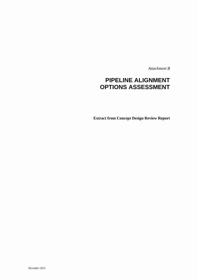
The MCA comparative assessment requires a ‘base case’. The conceptual design corridor (A1-B1-C1-D1) was nominated as the base case and assigned neutral (zero) ratings for all criteria in accordance with Melbourne Water’s MCA guidelines. Each sub-option within a section was then assessed against the corresponding base case and given a rating between -4 (very much worse) and +4 (very much better), as described in the Melbourne Water Triple Bottom Line guidelines and shown in Figure 2 below.
December 2013 B-17
Figure 2 MCA Scoring System
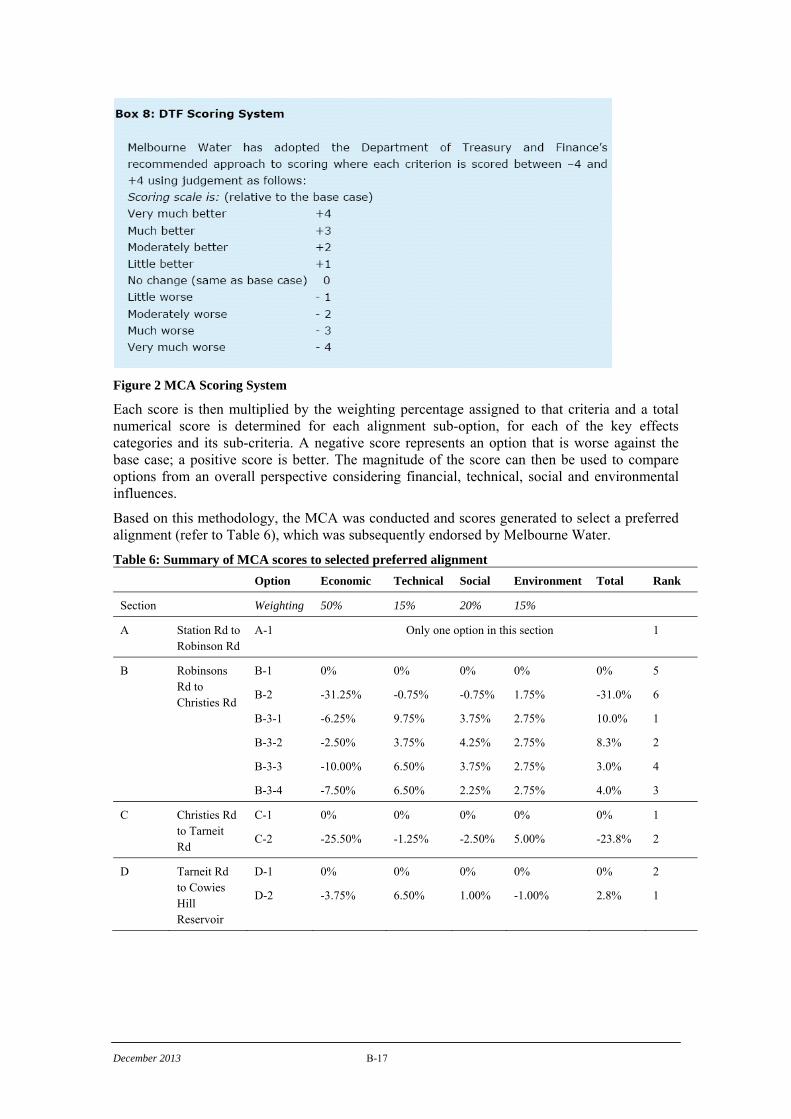
Each score is then multiplied by the weighting percentage assigned to that criteria and a total numerical score is determined for each alignment sub-option, for each of the key effects categories and its sub-criteria. A negative score represents an option that is worse against the base case; a positive score is better. The magnitude of the score can then be used to compare options from an overall perspective considering financial, technical, social and environmental influences.
Based on this methodology, the MCA was conducted and scores generated to select a preferred alignment (refer to Table 6), which was subsequently endorsed by Melbourne Water.
Table 6: Summary of MCA scores to selected preferred alignment
Option Economic Technical Social Environment Total Rank
Section Weighting 50% 15% 20% 15%
A Station Rd to Robinson Rd
A-1 Only one option in this section 1
B Robinsons Rd to Christies Rd
B-1
B-2
B-3-1
B-3-2
B-3-3
B-3-4
0%
-31.25%
-6.25%
-2.50%
-10.00%
-7.50%
0%
-0.75%
9.75%
3.75%
6.50%
6.50%
0%
-0.75%
3.75%
4.25%
3.75%
2.25%
0%
1.75%
2.75%
2.75%
2.75%
2.75%
0%
-31.0%
10.0%
8.3%
3.0%
4.0%
5
6
1
2
4
3
C Christies Rd to Tarneit Rd
C-1
C-2
0%
-25.50%
0%
-1.25%
0%
-2.50%
0%
5.00%
0%
-23.8%
1
2
D Tarneit Rd to Cowies Hill Reservoir
D-1
D-2
0%
-3.75%
0%
6.50%
0%
1.00%
0%
-1.00%
0%
2.8%
2
1

December 2013 B-18
PREFERRED ALIGNMENT
As determined by the MCA, the preferred alignment for the WGW pipeline is A-1, B-3-1, C-1, D-2.
This alignment presents many benefits including:
• Utilizing existing easements and road reserves where possible, therefore impacting fewer landowners;
• Overall relatively short pipeline length, with a total length of approximately 16.8 km (the base case alignment is 16.3 km, and the longest combination of sub-options is 18.5 km);
• Open trenched crossing of Deer Park Bypass reduces the construction risk inherent in trenchless installations, which also reduces the potential risk to the project’s construction schedule;
• Avoids Ravenhall NCR, which is protected golden sun moth habitat, along Christies Road, and avoids impacts on plains grassy wetland EVC.
This alignment and the associated project area required further detailed investigations in order to evaluate and quantify environmental and social effects, and to resolve design challenges.


