77
| Date post: | 09-Sep-2018 |
| Category: |
Documents |
| Upload: | phungnguyet |
| View: | 216 times |
| Download: | 1 times |

BIOLOGICAL ASSESSMENTFOR
ADDED COMBUSTION SOURCES AT THE PL PROPYLENE LLC FACILITY
HARRIS COUNTY, TEXAS
Submitted To:
U.S. ENVIRONMENTAL PROTECTION AGENCY, REGION VI MULTIMEDIA PLANNING AND PERMITTING DIVISION
FOUNTAIN PLACE 12TH FLOOR, SUITE 12001445 ROSS AVENUE
DALLAS, TEXAS 75202-2733
Submitted For:
PL PROPYLENE LLC9822 LA PORTE FREEWAY
HOUSTON, HARRIS COUNTY, TEXAS 77017
Submitted By:
ZEPHYR ENVIRONMENTAL CORPORATIONTEXAS REGISTERED ENGINEERING FIRM F-102
11200 WESTHEIMER ROAD, SUITE 600HOUSTON, TX 77042
APRIL 2013

BIOLOGICAL ASSESSMENTPL PROPYLENE, LLC EXPANSION PROJECT
Zephyr Environmental Corporation i
CONTENTS
ACRONYMS ................................................................................................................................. v
EXECUTIVE SUMMARY ............................................................................................................ vii
1.0 INTRODUCTION.................................................................................................................. 1
2.0 FEDERAL & STATE REGULATIONS .................................................................................. 3
2.1 REGULATIONS AND STANDARDS ................................................................................... 32.1.1 Clean Air Act .................................................................................................. 32.1.2 Endangered Species Act ................................................................................ 4
3.0 PROJECT DESCRIPTION ................................................................................................... 6
3.1 PROJECT PURPOSE ..................................................................................................... 63.2 CONSTRUCTION INFORMATION ..................................................................................... 6
3.2.1 Construction Activities .................................................................................... 63.2.2 Emission Controls .......................................................................................... 7
3.3 OPERATION AND MAINTENANCE INFORMATION .............................................................. 73.3.1 Operation ....................................................................................................... 73.3.2 Water Use ...................................................................................................... 83.3.3 Noise Effects .................................................................................................. 83.3.4 Infrastructure-related Effects .......................................................................... 83.3.5 Human Activity Effects ................................................................................... 8
3.4 WASTEWATER AND STORM WATER INFORMATION ......................................................... 94.0 ACTION AREA ................................................................................................................... 13
4.1 ACTION AREA DEFINITION .......................................................................................... 134.2 ACTION AREA DEFINITION METHODOLOGY.................................................................. 13
4.2.1 Ambient Air Dispersion Modeling ................................................................. 145.0 EXISTING CONDITIONS ................................................................................................... 16
5.1 NATURAL RESOURCES ............................................................................................... 165.1.1 Regional Setting ........................................................................................... 165.1.2 Land Use ...................................................................................................... 165.1.3 Topography .................................................................................................. 175.1.4 Geology ........................................................................................................ 175.1.5 Soils ............................................................................................................. 185.1.6 Vegetation .................................................................................................... 185.1.7 Water Resources ......................................................................................... 185.1.8 Climate ......................................................................................................... 19

BIOLOGICAL ASSESSMENTPL PROPYLENE, LLC EXPANSION PROJECT
Zephyr Environmental Corporation ii
5.2 FEDERALLY-LISTED THREATENED AND ENDANGERED SPECIES OF POTENTIAL OCCURRENCE WITHIN HARRIS COUNTY, TEXAS .......................................................... 195.2.1 Houston Toad............................................................................................... 205.2.2 Red-cockaded Woodpecker ......................................................................... 215.2.3 Whooping Crane .......................................................................................... 215.2.4 Smalltooth Sawfish ....................................................................................... 225.2.5 Louisiana Black Bear ................................................................................... 225.2.6 Red Wolf ...................................................................................................... 235.2.7 Green Sea Turtle.......................................................................................... 235.2.8 Kemp’s Ridley Sea Turtle ............................................................................. 245.2.9 Leatherback Sea Turtle ................................................................................ 245.2.10 Loggerhead Sea Turtle ................................................................................ 255.2.11 Atlantic Hawksbill Sea Turtle ........................................................................ 255.2.12 Texas Prairie Dawn flower ........................................................................... 26
5.3 NATURAL DIVERSITY DATABASE RESULTS .................................................................. 265.4 SPECIES LISTED BY NOAA ........................................................................................ 27
6.0 EFFECTS OF PROPOSED ACTION ................................................................................. 28
6.1 AIR POLLUTION EFFECTS BACKGROUND RESEARCH ................................................... 286.2 IMPACTS OF AIR POLLUTION ON PLANTS, SOIL, AND ANIMALS...................................... 296.3 CONSTRUCTION EFFECTS .......................................................................................... 31
6.3.1 Onsite Habitat Effects .................................................................................. 316.3.2 Noise Effects ................................................................................................ 316.3.3 Dust Effects .................................................................................................. 326.3.4 Human Activity ............................................................................................. 32
6.4 EFFECTS OF DISCHARGE OF WASTEWATER TO AQUATIC HABITAT ............................... 326.5 FEDERALLY-LISTED THREATENED AND ENDANGERED SPECIES HABITAT
EVALUATION .............................................................................................................. 326.5.1 Houston Toad............................................................................................... 326.5.2 Red-cockaded Woodpecker ......................................................................... 336.5.3 Whooping Crane .......................................................................................... 336.5.4 Smalltooth Sawfish ....................................................................................... 346.5.5 Louisiana Black Bear ................................................................................... 356.5.6 Red Wolf ...................................................................................................... 356.5.7 Green Sea Turtle.......................................................................................... 366.5.8 Kemp’s Ridley Sea Turtle ............................................................................. 366.5.9 Leatherback sea turtle .................................................................................. 376.5.10 Loggerhead Sea Turtle ................................................................................ 37

BIOLOGICAL ASSESSMENTPL PROPYLENE, LLC EXPANSION PROJECT
Zephyr Environmental Corporation iii
6.5.11 Atlantic Hawksbill Sea Turtle ........................................................................ 386.5.12 Texas Prairie Dawn flower ........................................................................... 386.5.13 Species Listed by NOAA .............................................................................. 39
6.6 DESIGNATED CRITICAL HABITAT ANALYSIS ................................................................. 397.0 CONCLUSIONS ................................................................................................................. 40
7.1 DETERMINATION OF EFFECT ...................................................................................... 407.2 POLLUTION CONTROL ................................................................................................ 40
7.2.1 Air Emissions ............................................................................................... 407.2.2 Wastewater and Storm Water ...................................................................... 42
8.0 LITERATURE CITED ......................................................................................................... 43
9.0 LIST OF PREPARERS ...................................................................................................... 46
TABLES
Table 4-1 Area of Interest Analysis Results from Preliminary Modeling1
Table 4-2 Impacts from Non-Criteria Pollutants1
Table 5-1 Land Use within the Action AreaTable 5-2 Geologic Units SummaryTable 5-3 NRCS Soil Units SummaryTable 5-4 All Species Listed by USFWS/NOAA as Having the Potential to Occur in Harris
CountyTable 6-1 Screening Analysis – Impacts on Plants, Soil, and Animals – Direct Impacts1
Table 6-2 NAAQS Modeling Results¹Table 7 Summary of Recommended Determinations of Effect
BIOLOGICAL ASSESSMENTPL PROPYLENE, LLC EXPANSION PROJECT
Zephyr Environmental Corporation iv
APPENDICES
Appendix A: Figure 3-1 Site Location Map
Figure 3-2 Construction Area/Plot Plan Figure 4-1 Project Site – Action Area Figure 5-1 Land Uses Figure 5-2 FEMA Flood Zone Map Figure 5-3 Geologic Units Figure 5-4 Soils Figure 5-5 NWI Data
Appendix B: Site Photographs
Appendix C: Field Survey Data Summary
BIOLOGICAL ASSESSMENTPL PROPYLENE, LLC EXPANSION PROJECT
Zephyr Environmental Corporation v
ACRONYMS
AOI area of significant impact AQRV air quality related values AVO olfactory BA biological assessment BACT best available control technology BMP best management practices CO carbon monoxide dBA decibels DLN Dry Low NOx
EPA U.S. Environmental Protection Agency ESA Endangered Species Act ESL effects screening level FCAA Federal Clean Air Act FEMA Federal Emergency Management Agency FHPM Federal-Aid High Program Manual FIRM flood insurance rate map GAT Geologic Atlas of Texas GE General Electric GHG greenhouse gas HRSG heat recovery steam generator LAER Lowest Achievable Emission Rate MMPA Marine Mammal Protection Act MW megawatt NAAQS National Ambient Air Quality Standards NH3 ammonia NMFS National Marine Fisheries Service NO2 nitrogen dioxide NOAA National Oceanic and Atmospheric Administration NOx nitrogen oxides NRCS Natural Resources Conservation Service NSR New Source Review NWI National Wetland Inventory NWS/AHPS National Weather Service/Advanced Hydrologic Prediction Service Pb lead PM particulate matter PM10 particulate matter with an aerodynamic diameter less than or equal to a nominal
10 micrometers PM2.5 particulate matter with an aerodynamic diameter less than or equal to a nominal
2.5 micrometers ppmvd parts per million by volume, dry basis PSD Prevention of Significant Deterioration RACT Reasonably Available Control Technology
BIOLOGICAL ASSESSMENTPL PROPYLENE, LLC EXPANSION PROJECT
Zephyr Environmental Corporation vi
SCR selective catalytic reduction SIL significant impact level SO2 sulfur dioxide TCAA Texas Clean Air Act TCEQ Texas Commission on Environmental Quality TPDES Texas Pollutant Discharge Elimination System TPWD Texas Parks and Wildlife TSP total suspended particulate TWDB Texas Water Development Board TXNDD Texas Natural Diversity Database USFWS U.S. Fish and Wildlife Service VOC volatile organic compounds
BIOLOGICAL ASSESSMENTPL PROPYLENE, LLC EXPANSION PROJECT
Zephyr Environmental Corporation vii
EXECUTIVE SUMMARY
PL Propylene LLC (PLP) is located at 9822 La Porte Freeway, Houston, Texas 77017. In 2010, the site’s Texas Commission on Environmental Quality (TCEQ) New Source Review (NSR) Permit No. 18999, was amended to authorize the construction of facilities to produce propylene using a licensed propane dehydrogenation technology (Catofin®). This permit amendment application is required to authorize the emissions of Greenhouse Gases (GHG) resulting from the installation of additional new combustion units, new heaters, a new waste heat boiler, a new flare, and associated natural gas piping. All of the new GHG sources are located within the current PLP property line. The proposed facilities are identical to existing facilities within the plant and emission quantities and concentrations are already well documented and anticipated to be equivalent.
The TCEQ is responsible for issuance of Prevention of Significant Deterioration (PSD) permits for all pollutants that have National Ambient Air Quality Standards (NAAQS). Since the TCEQ has not received PSD delegation for GHG, Environmental Protection Agency (EPA) is responsible for issuing GHG PSD permits.
This Biological Assessment (BA), a Federal New Source Review (FNSR) requirement, is an evaluation of the associated potential environmental impacts that the proposed expansion project may have on federally-protected species and/or their potential habitat within the projected area of impact. Protected species included in this document include federally-threatened, endangered species of Harris County as listed by the United States Fish and Wildlife Service (USFWS, and National Oceanic and Atmospheric Administration (NOAA). Habitat evaluations for this BA were accomplished via a pedestrian survey of the proposed expansion site as well as a windshield assessment of publicly accessible portions of the land-based Action Area. Subsequently, an evaluation of those resources based on air quality modeling results, construction and operational methodologies, and National Pollutant Discharge Elimination System (NPDES) information determined or gathered by Zephyr was accomplished.
Construction for the proposed expansion, associated infrastructure, and auxiliary equipment will take place within the existing plant footprint in an area approximately 200 meters by 200 meters. One laydown yard (200 feet by 200 feet) will be used adjacent to the existing facility. This parcel consists of former residential property.. The new facilities associated with the project include six new gas generators (FIN GT6 – GT11), a regeneration air heater (FIN RAH2), a charge gas heater (FIN RCH2), a waste heat boiler (FIN WHB2), and a flare (FIN FLARE2).
Federally-listed species considered in this BA include Houston toad, Red-cockaded Woodpecker, Whooping crane, Smalltooth sawfish, Louisiana black bear, Red wolf, Green sea turtle, Kemp's Ridley sea turtle, Leatherback sea turtle, Loggerhead sea turtle, Texas prairie dawn, Atlantic hawksbill sea turtle, Blue whale, Finback whale, Humpback whale, Sei whale, and Sperm whale. The habitat evaluation included a pedestrian survey of the proposed expansion site. The habitat evaluation also included a windshield survey of all land-based (upland) habitats visible from PL Propylene property as well as those visible from public

BIOLOGICAL ASSESSMENTPL PROPYLENE, LLC EXPANSION PROJECT
Zephyr Environmental Corporation viii
roadways within the Action Area. Data were collected to describe resident vegetation communities and assess the potential for occurrence of protected species. The dominant habitats are mostly upland grass species, hardwood trees and maintained residential grasses, shrubs and exotics.
To determine the Action Area for this BA, PLP performed dispersion modeling of the air pollutants that will be emitted as a result of the proposed project in accordance with the PSD Permit Air Quality Analysis requirements and TCEQ Effects Screening Level (ESL) analysis requirements. The definition of the Action Area boundary was based on the NAAQS pollutants. The Action Area boundary was also defined by Outfall 001 which discharges treated effluent to Sims Bayou. A construction laydown yard will occupy a portion (200 ft x 200 ft) of a former residential area adjacent to the existing facility. No linear features (i.e. pipelines) will be constructed as part of the proposed project. Based on this modeling, the Action Area was defined to extend to a maximum of 0.50 miles from the proposed project construction area.
Construction of the proposed project will have no direct impact on federally-listed species habitat. PLP will utilize the Best Available Control Technology (BACT) to control emissions and thus minimize impacts to the surrounding environment to the maximum extent practicable. Controls proposed for each pollutant are consistent with both the TCEQ BACT guidance and the most stringent limits in the EPA RACT/BACT/LAER Clearinghouse (RBLC).
Based on the background research described in Section 6.1 and the determinations described in Section 6.4, it is Zephyr’s opinion that the proposed expansion project will likely have no direct or indirect impact on federally-listed species habitat.
This BA provides the results of an evaluation of the potential for the proposed project to impact species within the Action Area that are protected under the Endangered Species Act (ESA). The following table summarizes the effect determination for each federally listed species with the potential to occur within Harris County according to the Annotated County Lists of Rare Species from TPWD and NOAA.
Summary of Recommended Determinations of Effect
Federally-listed Species Listing/Managing
Agency Recommended Determination
of Effect Houston toad USFWS No effect Red-cockaded woodpecker USFWS No effect Whooping Crane USFWS No effect Smalltooth sawfish NOAA No effect Louisiana black bear USFWS No effect Red wolf USFWS No effect Texas Prairie Dawn flower USFWS No effect Green sea turtle USFWS/NOAA No effect Kemp's Ridley sea turtle USFWS/NOAA No effect Leatherback sea turtle USFWS/NOAA No effect

BIOLOGICAL ASSESSMENTPL PROPYLENE, LLC EXPANSION PROJECT
Zephyr Environmental Corporation ix
Summary of Recommended Determinations of Effect
Federally-listed Species Listing/Managing Agency
Recommended Determination of Effect
Loggerhead sea turtle USFWS/NOAA No effect Atlantic hawksbill sea turtle NOAA No effect Blue whale NOAA No effect Finback whale NOAA No effect Humpback whale NOAA No effect Sei whale NOAA No effect Sperm whale NOAA No effect

BIOLOGICAL ASSESSMENTPL PROPYLENE, LLC EXPANSION PROJECT
Zephyr Environmental Corporation 1
1.0 INTRODUCTION
PLP currently operates a propane dehydrogenation unit at its plant site in Houston, Harris County, Texas. It is proposing to build a second dehydrogenation unit which entails the addition of a number of combustion sources whose emissions of Carbon Dioxide (CO2), Nitrogen Dioxide (NO2), and Methane (CH4) are great enough to result in PSD review for GHG. The site-wide emissions of total pollutants for the new facility are summarized in the following table.
Site-wide Emission Summary VOC NOx CO PM PM10 PM2.5 SO2 H2S NH3
(tons/yr) (tons/yr) (tons/yr) (tons/yr) (tons/yr) (tons/yr) (tons/yr) (tons/yr) (tons/yr)109.00 154.68 177.93 15.07 14.3 10.08 60.78 0.05 86.33
This BA is an evaluation of the associated potential environmental impacts that the proposed expansion project may have on federally-listed species and/or their potential habitat within the projected area of impact.
Protected species included in this document include federally-threatened, and endangered species as listed by the United States Fish and Wildlife Service (USFWS) and the National Oceanic and Atmospheric Administration (NOAA). A description of the federal agency regulations for the various protected species evaluated in this BA is presented in Section 2.0.
This BA was developed to investigate, qualify, quantify, and report the possible effects, including: direct and indirect, interdependent and interrelated actions that the proposed expansion may have on federally-protected species within the Action Area. Habitat evaluations for this BA were accomplished via pedestrian survey of the expansion site as well as a windshield assessment of publicly accessed portions of the land-based Action Area. Subsequently, an evaluation of those resources based on air quality modeling results, construction and operational methodologies, and NPDES information determined or gathered by Zephyr was accomplished.
Following a study of possible effects to federally listed species, a determination of effect will be stated. Per USFWS guidelines, the three possible determinations as described are as follows:
1. No affect - "No affect" means there will be no impacts, positive or negative, to listed or proposed resources. Generally, this means no listed resources will be exposed to action and its environmental consequences. Concurrence from the USFWS is not required.
2. May affect, but is not likely to adversely affect - "May affect, but is not likely to adversely affect" means that all effects are beneficial, insignificant, or discountable. Beneficial effects have contemporaneous positive effects without any adverse effects to the species or habitat. Insignificant effects relate to the size of the impact and include those effects that are undetectable, not measurable, or cannot be evaluated. Discountable effects are those extremely unlikely to occur. These determinations require written concurrence from the USFWS.

BIOLOGICAL ASSESSMENTPL PROPYLENE, LLC EXPANSION PROJECT
Zephyr Environmental Corporation 2
3. May affect, is likely to adversely affect - "May affect, and is likely to adversely affect" means that listed resources are likely to be exposed to the action or its environmental consequences and will respond in a negative manner to the exposure.
Note: A finding of "may affect, is likely to adversely affect" by an action agency and the USFWS requires "formal consultation" between the action agency and the USFWS. Formal consultation results in the USFWS issuing a biological opinion as to whether or not the action, as proposed, will jeopardize the continued existence of any listed species.

BIOLOGICAL ASSESSMENTPL PROPYLENE, LLC EXPANSION PROJECT
Zephyr Environmental Corporation 3
2.0 FEDERAL & STATE REGULATIONS
2.1 REGULATIONS AND STANDARDS
2.1.1 Clean Air Act
Both the Federal Clean Air Act (FCAA) and Texas Clean Air Act (TCAA) require that maximum ambient air quality concentration limits be established that are designed to protect public health, welfare and the environment. Ambient air is the air to which the general public has access, as opposed to air within the boundaries of an 'industrial facility.
The FCAA standards are the National Ambient Air Quality Standards (NAAQS) and are established by the US Environmental Protection Agency (EPA). The NAAQS are maximum concentration limits for specific pollutants in ambient air over a specific averaging time as established in the Code of Federal Regulations (40 CFR 50). The NAAQS are classified into two categories: primary and secondary standards. Primary standards are established to protect public health, including "sensitive" populations such as asthmatics, children and the elderly. Secondary standards are established to protect public welfare, including visibility, animals, crops, vegetation and buildings. The FCAA requires periodic review of the standards and the science upon which they are based to assure ongoing protection of the nation’s public health and environment. This review is thorough and extensive involving a science policy workshop to identify the key policy-relevant science issues to review, an integrated science assessment which is a comprehensive review, synthesis and evaluation of the science including risk and exposure assessments. Therefore these existing primary and secondary standards represent the current science related to protection of public welfare.
The EPA has established NAAQS for six principal air pollutants, also referred to as criteria air pollutants. These six criteria air pollutants are Carbon Monoxide (CO), Lead (Pb), Nitrogen Dioxide (NO2), Ozone, Particulates (PM2.5, PM10) and Sulfur Dioxide (SO2). The FCAA also establishes that geographic areas be classified as either having ambient concentrations above or below the established NAAQS. A geographic area whose ambient air concentration for a criteria pollutant is equal to or less than the primary standard is an attainment area. A geographic area with an ambient air concentration greater than the primary standard is a nonattainment area. A geographic area will have a separate designation for each criteria pollutant. Harris County has been designated as attainment for all the criteria pollutants except for Ozone. It is designated as nonattainment for Ozone and its precursor’s Nitrogen Oxides (NOx) and Volatile Organic Compounds (VOC).
In addition to NAAQS, the EPA has established PSD Increments which limits the increase in the ambient air concentration in an attainment area to an amount (the PSD increment) that will assure that the total ambient concentration in an attainment area continues to be below the NAAQS.
In order to obtain a PSD permit for criteria pollutants, an applicant is required to demonstrate with computer air dispersion modeling that the emissions from their proposed project will not

BIOLOGICAL ASSESSMENTPL PROPYLENE, LLC EXPANSION PROJECT
Zephyr Environmental Corporation 4
exceed the NAAQS and the PSD Increment for each emitted criteria pollutant. This demonstration is conducted in a two-step process. First the emissions from the new project are modeled to determine maximum off-property impacts. If those impacts are below a defined Significant Impact Level (SIL) for a specific pollutant and averaging period, then the increase in ambient concentration is considered to be insignificant and no further evaluation is required for that pollutant and averaging period. If the project impacts are above the SIL, then additional dispersion modeling is required in which the project emission increases are modeled along with other emissions sources in the area and that predicted impact is added to the background level and compared to the NAAQS and PSD Increment.
The TCEQ is the state agency charged with implementing the Texas Clean Air Act (TCAA) to control air pollution in order to protect human health or welfare, animal life, vegetation or property. To assess and assure that emission increases will be protective of human health, welfare, animal life, vegetation or property the TCEQ has established an effects evaluation process using Effect Screening Levels (ESLs) for pollutants for which a NAAQS has not been established. This ESL evaluation is implemented through the state permitting process in which computerized dispersion modeling is used to predict the ambient concentration of individual air contaminant species and then are compared to the published ESLs to determine acceptability of the proposed emissions.
Effects Screening Levels are chemical-specific air concentrations set to protect human health and welfare. Short-term ESLs are based on data concerning acute health effects, the potential for odors to be a nuisance, and effects on vegetation, while long-term ESLs are based on data concerning chronic health and vegetation effects. Health-based ESLs are set below levels where health effects would occur whereas welfare-based ESLs (odor and vegetation) are set based on effect threshold concentrations. The short-term ESL is the lowest value of acute odor, vegetation- and health-based ESLs. The long-term ESL is defined as the lowest value of chronic vegetation- or health-based ESLs. The ESL Published List includes ESLs for thousands of chemicals and can be found at: http://www.tceq.state.tx.us/implementation/tox/esl/list_main.html.
ESLs are not ambient air standards but rather are screening levels used in TCEQ’s air permitting process to evaluate the impacts predicted by air dispersion modeling, as described by TCEQ, ESLs are “used to evaluate the potential for effects to occur as a result of exposure to concentrations of constituents in the air. ESLs are based on data concerning health effects, the potential for odors to be a nuisance, and effects on vegetation.” Accordingly, if predicted concentrations of a constituent “do not exceed the screening level, adverse health or welfare effects are not expected.”
2.1.2 Endangered Species Act
Regulation of the Endangered Species Act (ESA) is accomplished by the USFWS and the National Oceanic and Atmospheric Administration - National Marine Fisheries Service (NOAA-NMFS). "The purpose of the ESA is to protect and recover imperiled species and the ecosystems on which they depend." Imperiled species specifically includes those listed by the USFWS as threatened or endangered.

BIOLOGICAL ASSESSMENTPL PROPYLENE, LLC EXPANSION PROJECT
Zephyr Environmental Corporation 5
Section 7 of the ESA requires Federal agencies to insure that any action authorized, funded or carried out by them is not likely to jeopardize the continued existence of listed species or modify their habitat.
The ESA prohibits the "take" of threatened and endangered species. "Take" is defined as "harass, harm, pursue, hunt, shoot, wound, kill, trap, capture, or collect, or attempt to engage in any such conduct." "Harm" is defined as "an act which actually kills or injures wildlife. Such an act may include significant habitat modification or degradation where it actually kills or injures wildlife by significantly impairing essential behavioral patterns, including breeding, feeding, or sheltering."
BIOLOGICAL ASSESSMENTPL PROPYLENE, LLC EXPANSION PROJECT
Zephyr Environmental Corporation 6
3.0 PROJECT DESCRIPTION
3.1 PROJECT PURPOSE
The purpose of this project is to increase the production of propylene by the dehydrogenation of propane. The proposed project is located within the PLP facility located at 9822 La Porte Freeway, Houston, TX 77017 (Figure 3-1, Appendix A).
3.2 CONSTRUCTION INFORMATION
Construction of the proposed expansion, associated infrastructure, and auxiliary equipment will take place within the existing facility in an area approximately 200 meters by 200 meters. No additional earth disturbance will be required outside of this area, which is currently undeveloped industrial land. The construction area is shown on Figure 3-2 (Appendix A).
The projected construction start date is January, 2013. The projected operation start date is October 2014.
3.2.1 Construction Activities
The total time estimated to complete the construction of the expansion project is approximately 20 months and includes the following list of general construction activities.
1. site preparation 2. new tie-ins 3. install auger cast piles for foundations 4. place concrete for combustion sources 5. install gas generators, heaters, ground level flare and associated electrical,
instrumentation6. install interconnecting piping from pipe rack to combustion sources 7. final piping tie-ins 8. completion of instrumentation & electrical work 9. insulation 10. touch-up painting
The project will be constructed on a 15-acre parcel located within the fence line of an existing industrial facility. These 15 acres are currently used for storage or laydown yards, transport, below ground piping, flare piping and other light industrial uses.
BIOLOGICAL ASSESSMENTPL PROPYLENE, LLC EXPANSION PROJECT
Zephyr Environmental Corporation 7
3.2.2 Emission Controls
As required by 30 Texas Administrative Code (TAC) §116.111(a)(2)(c), new or modified facilities must apply BACT, with consideration given to the technical practicability and economic reasonableness of reducing or eliminating the emissions from the facility and thereby minimizing the impact of emissions on the ambient air. TCEQ has established BACT guidance by emission source type and the EPA RACT/BACT/LAER Clearinghouse was consulted to determine if any additional controls should be considered. The new facilities associated with this project and their associated emission controls for each pollutant are summarized in below. These performance levels reflect emission control levels consistent with TCEQ guidance and the information available in EPA’s RACT/BACT/LAER Clearinghouse database. Section 7.0 (Conclusions) provides specific information on the project emission controls.
3.3 OPERATION AND MAINTENANCE INFORMATION
3.3.1 Operation
PLP will make propylene by the catalytic dehydrogenation of propane utilizing the proprietary Catofin® process. The following GHG combustion sources will be installed as part of this project.
Gas Generators Six new natural gas fired gas generators (FINs GT6 – GT11) will be added by this project. They will normally vent to a new waste heat boiler (FIN WHB2) except during performance of Maintenance, Startup, and Shutdown (MSS) activities when they each will vent directly to the atmosphere (FINs GT6/WHB2 MSS – GT11/WHB2 MSS) for a short period of time.
Regeneration Air Heater The exhaust gases from the new gas generators pass through a direct fired regeneration air heater (FIN RAH2) where supplemental fuel gas is used to raise the gases up to the temperature required for catalyst regeneration.
Charge Gas Heater A new charge gas heater (FIN RCH2) will be installed to heat the feed stream to the dehydrogenation unit. The heater emissions and will vent directly to the atmosphere following NOX control with a Selective Catalytic Reduction (SCR) unit (FIN RCH2SCR). During periods of MSS activity the vent composition is different than routine operations so emissions during these periods are shown separately (FIN RCH2MSS).
Waste Heat Boiler A new waste heat boiler (FIN WHB2) will be installed. Emissions from the regeneration air heater (FIN RAH2), catalyst regeneration units (FIN CATOFIN2), and the new gas generators (FINs GT6 – GT11) will normally go to this unit. NOX emissions will be controlled by a SCR (FIN WHB2SCR). CO emissions will be controlled by a CATOX unit (FIN WHB2CATOX) which converts CO to CO2. During periods of MSS activity, the WHB2 vent composition is different

BIOLOGICAL ASSESSMENTPL PROPYLENE, LLC EXPANSION PROJECT
Zephyr Environmental Corporation 8
than routine operations so emissions during these periods are shown separately (FIN WHB2MSS).
Piping Component Fugitives VOC emissions from the new process and fuel piping components are shown as FIN PLANT2.
FlareA new flare (FIN FLARE2) will be installed as part of this project. Routine emissions are shown as FIN FLARE2 and MSS emissions will be shown as FIN FLARE2MSS.
Maintenance/Startup/Shutdown (MSS) As mentioned above in the amendment summary, routine emissions from many of the FINs associated with this process will differ from emissions during MSS activities, and thus are shown separately on the NSR permit application Table 1(a) with a MSS designation.
3.3.2 Water Use
Untreated Surface water is supplied to the PLP plant by the City of Houston. PLP estimates a 100% increase in fresh water intake to provide for the new facilities associated with this project. This estimate equals an annual increase of roughly 2,200 gallons per minute (gpm) over the current estimated annual average freshwater intake of 2,200 gpm for the existing PLP Plant.
3.3.3 Noise Effects
The noise from construction and operations would be perceptible to humans and wildlife to some extent immediately adjacent to the facility. Noise levels from project activities should be comparable to noise levels currently from the plant. No noise effects to wildlife are expected as a result of the proposed project since the noise sources are constant and limited, rather than abrupt and excessive.
3.3.4 Infrastructure-related Effects
Land use impacts of the construction and operation of the expansion project will be limited to the site. Any increased noise, dust, and traffic from construction will be short-term for the duration of the project.
3.3.5 Human Activity Effects
Peak construction activities may require up to 1,000 additional workers within the facility. Although there will be a significant increase of activity within the facility during construction, it is not anticipated to have additional effects within or outside the facility. Operation of the expansion project will not require a significant increase of human activity compared to the current, regularly-occurring operational and maintenance activities at the plant. The facility will not propose an increase in shipping within the Houston Ship Channel because all
BIOLOGICAL ASSESSMENTPL PROPYLENE, LLC EXPANSION PROJECT
Zephyr Environmental Corporation 9
product incoming and outgoing are delivered via pipelines, trucks, and rail. The PLP facility is landlocked and has never used shipping as means of transporting product. No additional effects to wildlife are expected due to increased human activity from the expansion project.
3.4 WASTEWATER AND STORM WATER INFORMATION
The wastewater discharge from the PL Propylene, LLC facility is authorized by Texas Pollutant Discharge Elimination System (TPDES) Permit No. WQ0000393000 (TX0006068) and is made to an unnamed ditch thence to TCEQ Water Quality Segment No. 1007, Houston Ship Channel / Buffalo Bayou Tidal. The outfall location is located 2.85 miles upstream on Sims Bayou before eventually reaching the Houston Ship Channel.
Permit WQ0000393000 authorizes the discharge of treated process wastewater and utility wastewaters, hydrostatic test water, and storm water at a daily average flow not to exceed 1,500,000 gallons per day (1.5 MGD) via Outfall 001. The proposed expansion project is expected to raise the Outfall 001 daily average discharge from the current volume of 0.7 million gallons per day (MGD) to an estimated volume of 1.4 MGD, i.e. less than the permitted daily average flow. However, the wastewater generation processes and effluent quality of the Outfall 001 discharge are expected to be the same as those from the current plant configuration. The manufacturing processes proposed in the expansion will be identical to existing processes resulting in no change of pollutant concentrations in the effluent. Therefore the water quality data provided in the following table for Outfall 001 is being used as a surrogate for anticipated discharges for the proposed Project.
Outfall 002 is authorized for the discharge of storm water following first flush and incidental discharges of process wastewater, utility wastewater, and hydrostatic test water on an intermittent and flow variable basis. Consisting primarily of storm water, the discharge volumes of flow and water quality of this discharge will not be affected by this project.
The assessment of water quality impacts could be modeled using available modeling software to estimate conditions. However, the evaluation of using actual historic water quality data and process knowledge, along with whole effluent toxicity testing provides a superior assessment of potential impacts compared to modeling.
As displayed in the table below, the actual concentration of conventional pollutants and metals in the wastewater discharge from PL Propylene Outfall 001 as a result of the plant expansion project were compared to the most recent data available for the receiving stream, Sims Bayou Tidal (part of the Houston Ship Channel/Buffalo Bayou Tidal in Segment No. 1007 of the San Jacinto River Basin). The concentrations of constituents in the Outfall 001 were obtained from actual samples collected during wastewater monitoring in compliance with TPDES Permit No. WQ0000393000 (TX0006068). Information with regard to the water quality of Sims Bayou was obtained from the following sources:
(1) the EPA MyWATERS Mapper for water quality monitoring station No. 11302 located within the Sims Bayou Tidal,

BIOLOGICAL ASSESSMENTPL PROPYLENE, LLC EXPANSION PROJECT
Zephyr Environmental Corporation 10
(2) analytical data for station No. 11302 maintained in the EPA STORET (short for STOrage and RETrieval) Data Warehouse, and
(3) water quality information provided by the TCEQ for Segment 1007 of the San Jacinto River Basin.
According to the TCEQ database, Sims Bayou in the vicinity of the PL Propylene Outfall 001 has a 7-day, 2-year (7Q2) flow of 40.56 cubic feet per second or 26.213 MGD as compared to the increase of 0.7 MGD of wastewater discharge from the proposed expansion of the PL Propylene plant. The table below provides a calculation of the concentrations of constituents that would result from the mixture of the wastewater discharge from PL Propylene Outfall 001 expansion project with the water in Sims Bayou. A percent increase or decrease in the concentration of the mixture that would result from the wastewater discharge is provided in the last column. Due to the effective treatment of wastewater generated at the facility the water quality of Sims Bayou is actually improved as a result of the discharge at Outfall 001. The data indicates there is either no measurable change or that there is a negative (-) change (i.e. a water quality improvement) that would occur as a result of the incremental increase in the discharge to Sims Bayou from PL Propylene Outfall 001 for all parameters for which comparative water quality data was available. One such improvement includes dissolved oxygen where there is an increase of 0.32% in the concentration of the mixture. The only adverse change involves total suspended solids (TSS) which results in a negligible increase in TSS from 9.0 to 9.43 mg/l. Furthermore, this concentration will be further diluted by dispersion which will occur along the 2.85 mile path to the Houston Ship Channel.
PL Propylene Outfall 001 and Sims Bayou at Houston Ship Channel Tidal (1007) Monitored Pollutant Concentrations
Parameter
PL Propylene Wastewater
Average Concentration
Outfall 001 (mg/L) (Actual)
Sims Bayou Monitored Values
(mg/L)
Concentration of Mixture
Daily Avg. (mg/L)
PercentChange( + / - )
Conventional Constituents BOD (5-day) 3.65 NA N/A N/A CBOD (5-day) ND NA N/A N/A Chemical Oxygen Demand 52 NA N/A N/A Total Organic Carbon 19.9 NA N/A N/A Dissolved Oxygen 4.53 4.03 4.04 0.32% Ammonia Nitrogen 0.473 NA N/A N/A Total Suspended Solids 25.5 9 9.43 4.77% Nitrate Nitrogen 0.729 NA N/A N/A Total Organic Nitrogen 1.18 NA N/A N/A Total Phosphorous 0.894 NA N/A N/A Oil and Grease ND NA N/A N/A Total Residual Chlorine 0.04 NA N/A N/A

BIOLOGICAL ASSESSMENTPL PROPYLENE, LLC EXPANSION PROJECT
Zephyr Environmental Corporation 11
Parameter
PL Propylene Wastewater
Average Concentration
Outfall 001 (mg/L) (Actual)
Sims Bayou Monitored Values
(mg/L)
Concentration of Mixture
Daily Avg. (mg/L)
PercentChange( + / - )
Total Dissolved Solids 1170 NA N/A N/A Sulfate 426 NA N/A N/A Chloride 194 1080 1056.95 -2.13% Fluoride NA N/A N/A MetalsTotal Aluminum 1.23 NA N/A N/A Total Antimony <0.03 NA N/A N/A Total Arsenic 0.0118 0.02 0.0198 -1.07% Total Barium 0.219 141 137.3383 -2.60% Total Beryllium <0.004 0.62 N/A N/A Total Cadmium 0.0005 0.16 0.1559 -2.59% Total Chromium 0.0005 0.02 0.0195 -2.54% Trivalent Chromium N/A N/A N/A N/A Hexavalent Chromium <0.010 N/A N/A N/A Total Copper 0.0186 0.092 0.090091 -2.08% Cyanide <0.020 N/A N/A N/A Total Lead 0.0025 0.133 0.129606 -2.55% Total Mercury <0.0002 0.1 0.09740161 -2.60% Total Nickel 0.00689 0.13 0.12680 -2.46% Total Selenium <0.010 NA NA NA Total Silver <0.002 NA <0.004 0.00% Total Thallium <0.010 0.88 NA NA Total Zinc 0.074 0.192 0.003873 -1.60%
(Note: In performing these calculations, a value equal to ½ of the detection limit was used in cases where the concentration ofthe parameter in the PL Propylene Outfall 001 discharge was reported to be less than the detection limit.)
The TPDES permit requires that the final effluent be routinely analyzed using whole effluent toxicity (WET) testing methods per the requirements of 40 CFR 122.44(d)(1)(i). Studies have shown that the surrogate organisms used in WET testing are of similar sensitivity to listed threatened or endangered species and are reliable indicators of potential toxic effects (Mayer, et al 2008; Dwyer, et al. 2004; Sappington, et al. 2001). Toxicity in these tests is defined as a statistically significant difference at the 95% confidence interval between the survival, reproduction, or growth of the test organisms at or below a specified effluent dilution (i.e., the critical dilution) compared to the survival, reproduction, or growth or the test organisms in the control (i.e., 0% effluent). WET testing follows a pass/fail criterion with no calculation of specific concentrations of individual constituents. In this regard, any “harmful quantity” would be signaled by a test failure.
Through the past 5 years of record, WET testing performed on the facility Outfall 001discharge has not failed and thus has not indicated the presence of harmful quantities of toxic constituents in the effluent. Because the additional effluent generated by the proposed

BIOLOGICAL ASSESSMENTPL PROPYLENE, LLC EXPANSION PROJECT
Zephyr Environmental Corporation 12
expansion project will be handled exactly as for the current effluent, the effluent quality from the proposed expansion project is expected to be the same as the current discharge. For these reasons, the likelihood of toxicological impacts to aquatic life, including listed threatened or endangered species, should be discountable. Data shows that the concentrations of constituents in the wastewater discharge will have a negligible effect on the receiving waters and would actually improve water quality of the receiving stream.
The PLP facility will have an Oil and Hazardous Materials Spill Prevention, Control, and Countermeasure Plan and Storm Water Pollution Prevention Plan in place prior to operation and the facility employees will be trained to implement these plans. These plans will be utilized during operations, and maintenance of the proposed additional combustion sources.

BIOLOGICAL ASSESSMENTPL PROPYLENE, LLC EXPANSION PROJECT
Zephyr Environmental Corporation 13
4.0 ACTION AREA
4.1 ACTION AREA DEFINITION
The Action Area is defined as “all areas to be affected directly or indirectly by the Federal action and not merely the immediate area involved in the action” (50 C.F.R. 402.02). The analysis of species or designated critical habitat likely to be affected by the proposed project is focused on effects within the project’s Action Area. For this BA, the Action Area was determined by identifying the area in which the proposed project may result in significant direct and indirect impacts in and around the Project Site. Both construction and operation phases of the proposed combustion equipment were considered including wastewater outfalls; laydown yards; and any linear improvements such as water or fuel supply; or electrical transmission lines. Indirect impacts to surrounding areas may include noise, lighting, dust, erosion, stream sedimentation, wastewater discharge, air emissions, and physical disturbances. The Action Area was based in part on determining a de minimis effects boundary (see Section 2.1.1) as well as including any ancillary components.
Through air-dispersion modeling efforts, the Action Area boundary was defined to extend to a maximum distance of 0.50 miles (0.8 kilometers) from the Project Site and includes wastewater Outfall 001 at Sims Bayou (see Figure 4-1, Appendix A). This irregular-shaped area is defined to include any point outside the facility boundary where the air dispersion modeling suggests that a pollutant would exceed the significant impact level (SIL). The potential impacts to federally threatened and endangered species habitat were evaluated within the identified Action Area. The following sections describe the methodology used to delineate the Action Area for this BA.
4.2 Action Area Definition Methodology
As mentioned above, the Action Area was established in part using air emission dispersion modeling in such a manner as to ensure that any potential impact from emissions beyond the defined boundary of the Action Area would, by regulatory definition, be de minimis. The Action Area also includes wastewater Outfall 001 which discharges treated effluent to Sims Bayou. A single laydown yard to be used during construction is located adjacent to the facility and is within the Action Area defined by the air dispersion model. There are no linear features such as water or fuel supply extending laterally beyond the facility that will require construction.
The air dispersion boundary of the Action Area was conservatively delineated by using EPA’s SIL for criteria pollutants and “de minimis” levels for noncriteria pollutants. A SIL is established for each NAAQS, at a concentration significantly less than the corresponding NAAQS. By establishing such a de minimis threshold, EPA can ascertain when a potential impact is considered to be so low as to be insignificant.
The boundaries of the Area of Significant Impact (AOI) for a given pollutant and averaging period are defined by the number of modeling receptors for which predicted concentrations are
BIOLOGICAL ASSESSMENTPL PROPYLENE, LLC EXPANSION PROJECT
Zephyr Environmental Corporation 14
greater than the respective EPA de minimis levels. The Action Area for the biological assessment is the cumulative number of modeling receptors for all pollutants and averaging periods for which predicted concentration are greater than the respective de minimis levels.
4.2.1 Ambient Air Dispersion Modeling
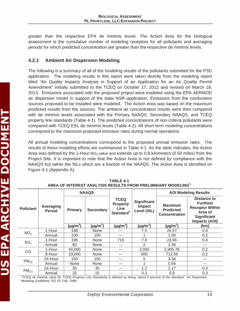
The following is a summary of all of the modeling results of the pollutants submitted for the PSD application. The modeling results in this report were taken directly from the modeling report titled “Air Quality Impacts Analysis in Support of an Application for an Air Quality Permit Amendment” initially submitted to the TCEQ on October 17, 2012 and revised on March 18, 2013. Emissions associated with the proposed project were modeled using the EPA AERMOD air dispersion model in support of the state NSR application. Emissions from the combustion sources proposed to be installed were modeled. The Action Area was based on the maximum predicted results from the sources. The ambient air concentration results were then compared with de minimis levels associated with the Primary NAAQS, Secondary NAAQS, and TCEQ property line standards (Table 4-1). The predicted concentrations of non-criteria pollutants were compared with TCEQ ESL de minimis levels (Table 4-2). All short term modeling concentrations correspond to the maximum proposed emission rates during normal operations.
All annual modeling concentrations correspond to the proposed annual emission rates. The results of these modeling efforts are summarized in Table 4-1. As the table indicates, the Action Area was defined by the 1-Hour NO2 value and extends up to 0.8 kilometers (0.50 miles) from the Project Site. It is important to note that the Action Area is not defined by compliance with the NAAQS but rather the SILs which are a fraction of the NAAQS. The Action Area is identified on Figure 4-1 (Appendix A).
TABLE 4-1 AREA OF INTEREST ANALYSIS RESULTS FROM PRELIMINARY MODELING1
Pollutant Averaging Period
NAAQS
TCEQProperty
LineStandard2
SignificantImpact
Level (SIL)
AOI Modeling Results
Primary SecondaryMaximumPredicted
Concentration
Distance to Furthest
Receptor Within Area of
SignificantImpacts (AOI)
(μg/m3) (μg/m3) (μg/m3) (μg/m3) (μg/m3) (km)
NO21-Hour 188 None --- 7.5 26.57 0.8 Annual 100 100 --- 1 1.06 0.2
SO21-Hour 196 None 715 7.8 23.66 0.4 Annual 80 None --- 2 1.39 ---
CO 1-Hour 40,000 None --- 2,000 2,905.76 0.2 8-Hour 10,000 None --- 500 712.56 0.2
PM1024-Hour 150 150 --- 5 3.34 --- Annual None None --- 1 0.69 ---
PM2.524-Hour 35 35 --- 1.2 2.17 0.4 Annual 15 15 --- 0.3 0.6 0.3
1TCEQ de minimis value for TCEQ Property Line Standards is defined as being “about 2 percent of the standard,” Air Dispersion Modeling Guidelines, RG 25, Feb. 1999.

BIOLOGICAL ASSESSMENTPL PROPYLENE, LLC EXPANSION PROJECT
Zephyr Environmental Corporation 15
TABLE 4-2 IMPACTS FROM NON-CRITERIA POLLUTANTS1
Pollutant Averaging Period
MaximumPredicted
Concentration2
TCEQESL % of ESL
(μg/m3) (μg/m3)
Ammonia 1-hour 16.0 170 9.4% Annual 1.76 17 10.3%
1,3-Butadiene 1-hour 7.27E-04 510 <0.1% Annual 7.43E-05 9.9 <0.1%
Benzene 1-hour 0.0203 170 <0.1% Annual 0.00207 4.5 <0.1%
1De minimis for emission increases of non-criteria pollutants with no federal or TCEQ ambient standards is 10% of the ESL (TCEQ, Modeling and Effects Review Applicability, APDG 5874, July 2009).
In summary, this Action Area boundary was established by considering both air emission dispersion modeling and the actual discharge of treated effluent at a wastewater outfall. Also considered in the definition of the boundary was the location of an adjacent laydown yard which lies within the Action Area (Figure 4-1 Appendix A). The project requires no linear features, such as water or fuel supply pipelines or electric transmission to construct.
BIOLOGICAL ASSESSMENTPL PROPYLENE, LLC EXPANSION PROJECT
Zephyr Environmental Corporation 16
5.0 EXISTING CONDITIONS
5.1 NATURAL RESOURCES
5.1.1 Regional Setting
The proposed project is located in southeast Harris County within the Gulf Coast Prairies and Marshes eco-region of Texas and the Austroriparian Biotic Province of North America. This biotic province spans from the piney woods of East Texas to the Gulf of Mexico and through the southeastern U.S. to the Atlantic Ocean and is characterized locally by pine and hardwood forests and high moisture of the Eastern Gulf Coastal plain.
The climate of the Gulf Coast Prairies and Marshes eco-region is mild and warm with high humidity. Average annual rainfall varies from 30 to 50 inches per year distributed fairly uniformly throughout the year. The growing season is usually more than 300 days. The Gulf Coast Prairies and Marshes region is a nearly level, slowly drained plain less than 150 feet in elevation, dissected by streams and rivers flowing into the Gulf of Mexico. The region includes barrier islands along the coast, salt grass marshes surrounding bays and estuaries, remnant tall grass prairies, oak parklands and oak mottes scattered along the coast, and tall woodlands in the river bottomlands (TPWD 1996).
The original vegetation of the northern humid coastal prairies was mostly grasslands with a few clusters of oaks, known as oak mottes or maritime woodlands. Little bluestem, yellow Indiangrass, brownseed paspalum, gulf muhly, and switchgrass were the dominant grassland species. Almost all of the coastal prairies have been converted to cropland, rangeland, pasture, or urban land uses. The exotic Chinese tallow tree and Chinese privet have invaded large areas in this region. Some loblolly pine occurs in the northern part of the region. Appendix B shows photographs of the PLP facility as well as surrounding areas within the Action Area where accessible. Appendix C contains a summary of field notes collected during the habitat assessment.
5.1.2 Land Use
Approximately three-quarters of the land use in Harris County is devoted to residential, commercial and industrial sprawl of the City of Houston and its suburbs. The smaller portions dedicated to agriculture include rice, soybeans, grains, hay, corn, and vegetable farming as well as ranching and poultry farming (TSHA, 2012).
Land uses within the Action Area of the proposed expansion site are listed in Table 5-1 and illustrated in Figure 5-1.

BIOLOGICAL ASSESSMENTPL PROPYLENE, LLC EXPANSION PROJECT
Zephyr Environmental Corporation 17
TABLE 5-1 LAND USE WITHIN THE ACTION AREA
Land Use Acres Percent Industrial 152.07 82.48
Residential 16.52 8.96 Cropland and Pasture 8.53 4.63
Transportation and Communications 7.24 3.93
TOTAL 184.36 100
5.1.3 Topography
Harris County is situated along the southeastern Texas Gulf Coast near the border of Louisiana. Topography of the Western Gulf Coastal Plain is predominantly flat, sloping gently southeast with occasional hills and scarps produced by salt domes and subsurface faulting (USDA Soil Survey, 1976). Elevations in the project area range from 43 to 21 feet above sea level, sloping gently northeast towards the Houston Ship Channel (USGS 7.5 Minute Topographic Maps – Park Place and Pasadena Quadrants).
According to the Federal Emergency Management Agency (FEMA) flood insurance rate map (FIRM), the proposed project site is located in Zone X – an area of minimal flood hazard above the 500-year floodplain.
5.1.4 Geology
The Geologic Atlas of Texas (GAT) indicates the proposed project expansion site is underlain by unconsolidated Quaternary-age clays of the Beaumont Formation. Sediments of the Beaumont Formation consist mostly of grey clays and mud with interbedded lenses of yellow-orange to brown sand, silt and minor gravel layers. Geologic units in the vicinity of the project area include Beaumont Formation sands, Quaternary alluvium, and fill and spoil. Fill and spoil (dredge materials) from the Houston Ship Channel are used to create dredged material areas (DMA) in and around Houston.
Mineral resources in the area include oil and gas developments as well as salt and lime production (USDA Soil Survey, 1976).
The geologic units found within and surrounding the proposed project area are listed and described below in Table 5-2 and illustrated in Figure 5-3.
TABLE 5-2 GEOLOGIC UNITS SUMMARY
Map Unit Formation Name Description Qbc Beaumont Formation Subdivided into areas of dominantly clay
BIOLOGICAL ASSESSMENTPL PROPYLENE, LLC EXPANSION PROJECT
Zephyr Environmental Corporation 18
5.1.5 Soils
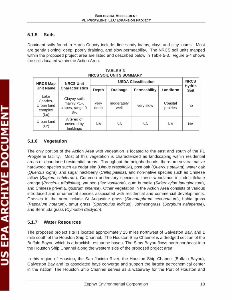
Dominant soils found in Harris County include: fine sandy loams, clays and clay loams. Most are gently sloping, deep, poorly draining, and slow permeability. The NRCS soil units mapped within the proposed project area are listed and described below in Table 5-3. Figure 5-4 shows the soils located within the Action Area.
TABLE 5-3 NRCS SOIL UNITS SUMMARY
NRCS Map Unit Name
NRCS Unit Characteristics
USDA Classification NRCS Hydric
Soil Depth Drainage Permeability Landform Lake
Charles-Urban land
complex (Lu)
Clayey soils mainly <1%
slopes, range 0-8%
very deep
moderately well very slow Coastal
prairies no
Urban land (Ur)
Altered or covered by buildings
NA NA NA NA NA
5.1.6 Vegetation
The only portion of the Action Area with vegetation is located to the east and south of the PL Propylene facility. Most of this vegetation is characterized as landscaping within residential areas or abandoned residential areas. Throughout the neighborhoods, there are several native hardwood species such as cedar elm (Ulmus crassifolia), post oak (Quercus stellata), water oak (Quercus nigra), and sugar hackberry (Celtis pallida), and non-native species such as Chinese tallow (Sapium sebiferum). Common understory species in these woodlands include trifoliate orange (Poncirus trifoliolata), yaupon (Ilex vomitoria), gum bumelia (Sideroxylon lanuginosum),and Chinese privet (Ligustrum sinense). Other vegetation in the Action Area consists of various introduced and ornamental species associated with residential and commercial developments.Grasses in the area include St Augustine grass (Stenotaphrum secundatum), bahia grass (Paspalum notatum), smut grass (Sporobulus indicus), Johnsongrass (Sorghum halepense),and Bermuda grass (Cynodon dactylon).
5.1.7 Water Resources
The proposed project site is located approximately 15 miles northwest of Galveston Bay, and 1 mile south of the Houston Ship Channel. The Houston Ship Channel is a dredged section of the Buffalo Bayou which is a brackish, estuarine bayou. The Sims Bayou flows north-northeast into the Houston Ship Channel along the western side of the proposed project area.
In this region of Houston, the San Jacinto River, the Houston Ship Channel (Buffalo Bayou), Galveston Bay and its associated bays converge and support the largest petrochemical center in the nation. The Houston Ship Channel serves as a waterway for the Port of Houston and

BIOLOGICAL ASSESSMENTPL PROPYLENE, LLC EXPANSION PROJECT
Zephyr Environmental Corporation 19
allows large, seafaring ships passage and ultimately connects to the Gulf Intracoastal Waterway in Galveston Bay (POH, 2012).
According to the Texas Water Development Board (TWDB), the Gulf Coast aquifer underlies the entirety of Harris County, and is used for municipal, industrial, and irrigation purposes (TWDB, 2012).
The USFWS National Wetland Inventory (NWI) data within and immediately adjacent to, the proposed project area is demonstrated in Figure 5-5.
5.1.8 Climate
Harris County's climate is predominantly marine, with cool summer nights and mild winters influenced by the gulf winds. According to the Harris County Flood Control District, the average annual precipitation in the region is 48.19 inches. The average annual growing season is 300 days. In winter, the average temperature is 48°F. In summer, the average temperature is 93°F. Prevailing winds are from the south-southeast with an average speed of 7.5 miles per hour except in January when polar air brings northerly winds (USDA Soil Survey, 1976). Average humidity is 90 percent in the morning with a lower average humidity of 63 percent at night.
At the time of this review, the U.S. Drought Monitor indicated the study area has no drought conditions (USDM, 2012), and the Long-Term Palmer Drought Severity Index rates this area as near normal, -1.9 to +1.9 inches of rain (CPC, 2012). According to the National Weather Service/Advanced Hydrologic Prediction Service (NWS/AHPS), the region has received approximately 6 to 8 inches rain within the 30 days prior to this review. This is approximately twice the average rainfall for this time of year (NWS/AHPS, 2012).
5.2 FEDERALLY-LISTED THREATENED AND ENDANGERED SPECIES OF POTENTIAL OCCURRENCE WITHIN HARRIS COUNTY, TEXAS
Table 5-4 lists all federal threatened, endangered species listed by USFWS and the TPWD as having the potential to occur in Harris County and from NOAA as having the potential to occur along the Texas portion of the Gulf Coast.

BIOLOGICAL ASSESSMENTPL PROPYLENE, LLC EXPANSION PROJECT
Zephyr Environmental Corporation 20
TABLE 5-4 ALL SPECIES LISTED BY USFWS/NOAA AS HAVING THE
POTENTIAL TO OCCUR IN HARRIS COUNTY
Common Name Scientific Name Federal Status Houston Toad Anaxyrus houstonensis Endangered
Red-cockaded Woodpecker Picoides borealis Endangered Whooping Crane Grus americana Endangered
Smalltooth Sawfish Pristis pectinata Endangered Louisiana black bear Ursus americanus luteolus Threatened
Red wolf Canis rufus Endangered Texas Prairie Dawn Hymenoxys texana Endangered
Green sea turtle Chelonia mydas Threatened Kemp's Ridley sea turtle Lepidochelys kempii Endangered Leatherback sea turtle Dermochelys coriacea Endangered Loggerhead sea turtle Caretta caretta Threatened
Atlantic hawksbill sea turtle Eretmochelys imbricata Endangered Blue whale Balaenoptera musculus Endangered
Finback whale Balaenoptera physalus Endangered Humpback whale Megaptera novaeangliae Endangered
Sei whale Balaenoptera borealis Endangered Sperm whale Physeter macrocephalus Endangered
A brief description of each of these species and their habitat requirements are included below.
5.2.1 Houston Toad
The Houston toad is 2 to 3.5 inches long. Its general coloration varies from light brown to gray or purplish gray, sometimes with green patches. The pale underside often has small, dark spots. Males have a dark throat which appears bluish when distended. The Houston toad requires loose, deep sands supporting woodland savannah and still or flowing waters for breeding (TPWD 2012). The Houston toad is a year-round resident where found. Their presence is most easily detected during the breeding season when males can be heard calling. Males typically can be heard calling within or near a breeding pond. Occasionally they may be heard calling from a wooded habitat located within 100 yards from a breeding pond. Breeding periods for these toads occur from December through June. Most breeding activity occurs in February and March (TPWD 2012).
Habitat for the Houston toad is characterized as pine or post oak woodland or savannah with native bunchgrasses and forbs occupying the open areas and woodland edges. Vegetation found in the habitat of known Houston toad populations include loblolly pine (Pinus taeda), post oak (Quercus stellata), black-jack oak (Q. marilandica), bluejack or sand-jack oak (Q. incana),yaupon (Ilex vomitoria), and little bluestem (Schizachyrium scoparium) (TPWD 2012).

BIOLOGICAL ASSESSMENTPL PROPYLENE, LLC EXPANSION PROJECT
Zephyr Environmental Corporation 21
Historically, Houston toads ranged across the central coastal region of Texas. Houston toads disappeared from the Houston area (Harris, Fort Bend and Liberty counties) during the 1960s following an extended drought and the rapid urban expansion of the City of Houston (USFWS 2011). Currently the largest population of Houston toads exists in Bastrop County.
5.2.2 Red-cockaded Woodpecker
The red-cockaded woodpecker is a non-migratory black and white woodpecker with distinctive white bars on its back creating a ladder pattern. The head is black with white cheek patches, and the chest is dull white with small black spots. Red-cockaded woodpeckers require open pine woodlands and savannahs with large old pines for nesting and roosting habitat (clusters). Large old pines are required as cavity trees because the cavities are excavated completely within inactive heartwood, so that the cavity interior remains free from resin that can entrap the birds. Also, old pines are preferred as cavity trees, because of the higher incidence of the heartwood decay that greatly facilitates cavity excavation. Cavity trees must be in open stands with little or no hardwood midstory and few or no overstory hardwoods. Hardwood encroachment resulting from fire suppression is a well-known cause of cluster abandonment. Redcockaded woodpeckers also require abundant foraging habitat. Suitable foraging habitat consists of mature pines with an open canopy, low densities of small pines, little or no hardwood or pine midstory, few or no overstory hardwoods, and abundant native bunchgrass and forb groundcovers (USFWS 2003).
Historic distribution of the red-cockaded woodpecker included Harris County. The degradation and elimination of old-growth pine forest has limited the potential of the red-cockaded habitat to smaller parcels and isolated fragments. Fire suppression has resulted in hardwood mid-story encroachment, which in turn has become the leading cause of red- cockaded woodpecker cavity abandonment (USFWS 2003). There is no potential habitat within the Action Area for these birds. Several stands of trees exist in the Action Area, but they are primarily hardwoods located within the adjacent neighborhood and along Sims Bayou.
5.2.3 Whooping Crane
At nearly 5 feet (1.5 m) tall, whooping cranes are the tallest birds in North America. They have a wingspan of 7.5 feet (2.3 m). The whooping crane is also one of North America’s rarest bird species with fewer than 400 birds remaining in wild population according to a count conducted in July 2010 (USFWS 2012). Whooping cranes are white with rust-colored patches on top and back of head, lack feathers on both sides of the head, yellow eyes, and long, black legs and bills. Their diet consists of blue crabs, clams, frogs, minnows, rodents, small birds, and berries. Whooping cranes prefer salt flats and marshes and coastal prairies with swales and ponds.
There is only one self-sustaining wild population, the Aransas-Wood Buffalo National Park population, which nests in Wood Buffalo National Park and adjacent areas in Canada, and winters in coastal marshes in Texas at Aransas. The migration route for the whooping crane is

BIOLOGICAL ASSESSMENTPL PROPYLENE, LLC EXPANSION PROJECT
Zephyr Environmental Corporation 22
west of Harris County. The cranes winter in the Aransas National Wildlife Refuge approximately 133 miles southwest of Houston. There is no habitat for the whooping crane in the Action Area and no documented sightings (TXNDD 2012).
5.2.4 Smalltooth Sawfish
Sawfish get their name from their "saws"--long, flat snouts edged with pairs of teeth which are used to locate, stun, and kill prey. Their diet includes mostly fish but also some crustaceans.
Smalltooth sawfish is one of two species of sawfish that inhabit U.S. waters. Smalltooth sawfish commonly reach 18 ft (5.5 m) in length, and may grow to 25 ft (7 m). Little is known about the life history of these animals, but they may live up to 25-30 years, maturing after about 10 years. Sawfish species inhabit shallow coastal waters of tropical seas and estuaries throughout the world. They are usually found in shallow waters very close to shore over muddy and sandy bottoms. They are often found in sheltered bays, on shallow banks, and in estuaries or river mouths. Designated critical habitat for smalltooth sawfish exists along the Florida gulf coast.
Juvenile sawfish use shallow habitats with a lot of vegetation, such as mangrove forests, as important nursery areas. Many such habitats have been modified or lost due to development of the waterfront in Florida and other southeastern states. The loss of juvenile habitat likely contributed to the decline of this species.
Smalltooth sawfish have been reported in the Pacific and Atlantic Oceans, and Gulf of Mexico; however, the U.S. population is found only in the Atlantic Ocean and Gulf of Mexico. Historically, the U.S. population was common throughout the Gulf of Mexico from Texas to Florida, and along the east coast from Florida to Cape Hatteras. The current range of this species has contracted to peninsular Florida, and smalltooth sawfish are relatively common only in the Everglades region at the southern tip of the state.
Sawfish are extremely vulnerable to overexploitation because of their propensity for entanglement in nets, their restricted habitat, and low rate of population growth.
The decline in smalltooth sawfish abundance has been caused primarily by catch in various fisheries, especially in gill nets. Because adults can grow very large, and potentially damage fishing gear of even pose a threat to fishermen, many incidentally captured sawfish were killed before they were removed from fishing gear, even if the fishermen had no interest in keeping them.
5.2.5 Louisiana Black Bear
Louisiana black bears range from 120-400 lbs with adult males being larger than adult females. Louisiana black bears are primarily inhabitants of bottomland hardwoods and floodplain forests, but also can also be found in upland hardwoods, mixed pine/hardwoods, coastal flatwoods, and marshes.

BIOLOGICAL ASSESSMENTPL PROPYLENE, LLC EXPANSION PROJECT
Zephyr Environmental Corporation 23
Females have a litter or 1 to 3 cubs every other winter while denning, and the cubs usually spend their first 1.5 to 2 years with their mother before dispersing. Bears emerge from dens in April and remain active until November, during the summer they eat mostly berries, insects, and carrion. In order to gain weight for the winter, bears eat nuts such as acorns and pecans which are high in carbohydrates and fats. They hibernate in the winter in large hollow trees, downed logs, or in ground nests which are shallow depressions lined with vegetation. Denning bears exhibit varying degrees of awareness, but most can easily be roused if disturbed. Although not true hibernators, bears generally do not eat, drink, urinate or defecate in winter. They have a unique metabolic process to recycle waste products during winter dormancy.
Habitat loss has been the main reason for the bear's decline. Reservoir construction has flooded many miles of former bottomland hardwood habitat. In addition, many bottomlands forests have been cut and converted to agricultural areas or housing developments.
5.2.6 Red Wolf
A rather small, slender, long-legged wolf resembling the coyote in color but often blackish; typically larger, with wider nose pad, larger feet and coarser pelage; smaller and more tawny than the gray wolf.
Formerly, red wolves ranged throughout the southeastern USA but their numbers and range quickly declined under pressure of intensive land use. Also, land management practices allowed the coyote to expand its range east; hybrid offspring of interbreeding red wolves and coyotes more closely resembled coyotes and the genetic identity of the red wolf was gradually lost.
Red wolves inhabited brushy and forested areas, as well as the coastal prairies where they preyed upon rabbits, deer, rodents, prairie chickens, fish and crabs, as well as upon domestic livestock, especially free-ranging pigs.
The red wolf was apparently extinct in the wild by 1980. The last six pure blood red wolves that could be found were captured in southeast Texas and moved to a canine breeding facility. Eventually, after the successful breeding of pure blood red wolves was accomplished, small packs were re-established upon barrier islands of North and South Carolina. Additional re-introduction efforts have occurred with the goal of creating a viable red wolf population large enough so that the red wolf can be removed from the endangered species list.
5.2.7 Green Sea Turtle
Green Sea Turtles range throughout the tropical ocean regions. During the day, Green Sea Turtles feed in the seagrass beds that grow in shallow waters with small amounts of sponges, crustaceans, sea urchins, and molluscs. The turtles migrate from nesting areas to feeding grounds, which are sometimes several thousand miles away. The major nesting beaches are always found in places where the seawater temperature is greater than 25 C.

BIOLOGICAL ASSESSMENTPL PROPYLENE, LLC EXPANSION PROJECT
Zephyr Environmental Corporation 24
Adults reach sexual maturity between 8 and 13 years of age. Adults mate every 2 to 3 years during the nesting season just off the nesting beaches. Green sea turtles are reported to live for 50 years or more and can grow to 850 pounds.
Sharks and humans are predators of the Green Sea Turtle. Exploitation of the nesting grounds either by human interference or pollution poses the greatest threat to these turtles (NOAA – Office of Protected Resources, Green Turtle (Chelonia mydas), http://www.nmfs.noaa.gov/pr/species/turtles/green.htm, accessed 7/20/2012c). In the past, Green Sea Turtles were often killed in large shrimp trawl nets. The Green Sea Turtle is an occasional visitor to the Texas coast. Designated critical habitat for the species exists near Puerto Rico.
5.2.8 Kemp’s Ridley Sea Turtle
The Kemp's Ridley sea turtle is considered the smallest sea turtle with an olive-gray carapace and a triangular shaped head and a hooked beak. Adults can grow to about two feet in length and weigh up to 100 pounds. This turtle is a shallow water benthic feeder with a diet consisting primarily of shrimp, jellyfish, snails, sea stars, and swimming crabs.
Most nesting occurs on the eastern coast of Mexico, however a small number consistently nest at Padre Island National Seashore in Texas and various other locations along the Gulf and lower Atlantic coasts. Nesting occurs from May to July during daylight hours (NOAA – Office of Protected Resources, Kemp's Ridley Turtle (Lepidochelys kempii),http://www.nmfs.noaa.gov/pr/species/turtles/kempsridley.htm, accessed 7/20/2012d). Large numbers of females emerge for a synchronized nesting event referred to as "arribada". Arribadas are thought to be caused by female pheromone release, offshore winds, and/or lunar cycles. Females nest up to 4 times per season at intervals of 10 to 28 days. The preferred nesting beaches are adjacent to extensive swamps or large bodies of open water.
The Kemp's Ridley turtles range includes the Gulf coasts of Mexico and the US, and the Atlantic coast of North America as far north as Nova Scotia and Newfoundland. There is currently no designated critical habitat for the species.
5.2.9 Leatherback Sea Turtle
The leatherback sea turtle is the largest sea turtle. The adult leatherback can get up to 8 feet in length and up to 2000 pounds. The turtle lacks a "normal" turtle shell and is covered by firm, rubbery skin that is approximately 4 inches thick. Coloration is predominantly black with varying degrees of pale spotting; including a notable pink spot on the dorsal surface of the head in adults. Diet is primarily jellyfish and salp, but it is also known to feed on sea urchins, squid, crustaceans, tunicates, fish, blue-green algae, and floating seaweed.

BIOLOGICAL ASSESSMENTPL PROPYLENE, LLC EXPANSION PROJECT
Zephyr Environmental Corporation 25
Leatherbacks are highly migratory and the most pelagic of all sea turtles. Females prefer high energy, sandy beaches with vegetation immediately upslope and a beach sloped sufficiently so the crawl to dry sand is not too far. Preferred beaches have deep, unobstructed oceanic access on continental shorelines.
In the United States, nesting occurs from March to July. Females nest on average 6 times per season at 10 day intervals. Most leatherbacks return to their nesting beaches at 2 to 3- year intervals. eNOAA – Office of Protected Resources, Leatherback Turtle (Dermochelys coriacea), http://www.nmfs.noaa.gov/pr/species/turtles/leatherback.htm, accessed 7/20/2012e).
Distribution is worldwide in tropical and temperate waters of the Atlantic, Pacific, and Indian Oceans. The leatherback is also found in small numbers as far north as British Columbia, Newfoundland, and the British Isles and as far south as Australia and Argentina. The leatherback has a small presence in the US with most nesting occurring on the Florida east coast, Sandy Point, US Virgin Islands, and Puerto Rico. Designated critical habitat for the species exists near the US Virgin Islands.
5.2.10 Loggerhead Sea Turtle
The loggerhead sea turtle is reddish-brown marine turtle characterized by a large head with blunt jaws. Adults can be up to 500 pounds and 4 feet in length. Adult loggerheads feed on jellyfish, floating egg clusters, flying fishes, mollusks, crustaceans, and other marine animals.
The nesting season in the US is May through August. Nesting occurs every 2 to 3 years and is mostly nocturnal. Females can nest up to 5 times per season at intervals of approximately 14 days. Hatchling emergence is mostly nocturnal. Loggerheads nest on oceanic beaches between the high tide line and dune fronts and occasionally on estuarine shorelines with suitable sand. Females prefer narrow, steeply sloped, coarse grained beaches.
Distribution of the loggerhead includes the temperate and tropical regions of the Atlantic, Pacific, and Indian Oceans. Although the majority (-80%) of the US nesting activity occurs in south Florida, loggerheads nest along the Gulf and Atlantic coastlines from Texas to Virginia (NOAA – Office of Protected Resources, Loggerhead Turtle (Caretta caretta),http://www.nmfs.noaa.gov/pr/species/turtles/loggerhead.htm, accessed 7/20/2012f). Loggerheads are considered an occasional visitor to Texas. There is currently no designated critical habitat for the species.
5.2.11 Atlantic Hawksbill Sea Turtle
The USFWS describes the hawksbill sea turtle as a small to medium-sized marine turtle commonly 2.5 feet in length and weighing between 95 to 165 pounds.
Hawksbill hatchlings are ocean going, and often found in the weedlines that accumulate at convergence zones. Juveniles will return to a coastal environment when their carapace reaches
BIOLOGICAL ASSESSMENTPL PROPYLENE, LLC EXPANSION PROJECT
Zephyr Environmental Corporation 26
approximately 20-25 centimeters in length. Juveniles and adults will spend most of their time foraging on sponges in coral reefs (NOAA – Office of Protected Resources, Hawksbill Turtle (Eretmochelys imbricata), http://www.nmfs.noaa.gov/pr/species/turtles/hawksbill.htm, Accessed 7/20/2012b).
Hawksbill turtle nesting occurs between April and November on low and high energy beaches in tropical oceans. Nesting habitat is often shared with green sea turtles. Hawksbills are typically associated with rocky areas and coral reefs in water less than 65 feet. Mexico is now considered the most important region for hawksbills in the Caribbean yielding 3,000 to 4,500 nests/year. The Hawksbill is an occasional visitor to the Texas coast Designated critical habitat for the species exists near Puerto Rico.
5.2.12 Texas Prairie Dawn flower
Texas prairie dawn-flower is an annual forb up to 8 inches tall with small yellow disk flowers (smaller than 0.5 inch in diameter) and minute pale ray flowers that are largely hidden by the bracts surrounding the flower head (Tveten and Tveten 1993). Texas prairie dawn-flowers bloom from March to July and disappear by mid-summer, completing their life cycle in the moist months of early spring to avoid the desiccating summer conditions (USFWS 1989).
Texas prairie dawn-flower is mostly found on nearly level, loamy prairie soils of the Hockley-Gessner and Katy-Aris associations. A few sites have been found on nearly level somewhat poorly drained saline soils of the Narta series. The high soil salinity of these bare spots prevents most plants from growing and reduces the competition for the more salt-tolerant Texas prairie dawn-flower (USFWS 1989). Correll and Johnston (1970) noted that this species was “rare in sandy soils near Hockley and Houston, Harris Co., [and] probably extinct.” However this species has been rediscovered in several locations in western Harris and eastern Fort Bend Counties, within and on the outskirts of Houston (USFWS 1989, TPWD 2011f). Much of the remaining habitat is protected on U.S. Army Corps of Engineers public lands such as Addicks and Barker Reservoirs in western Harris County. Habitat destruction by urban development and road construction is the Texas prairie dawn-flower’s primary threat due to the rapidly developing west and northwest portions of Harris County. This species has never been found on soils disturbed by plowing or other activities that destroy the soil horizon and thus, “any activity that severely disturbs the soil could be a severe threat to this species (USFWS 1989).
Based on the TXNDD data, the nearest record of the Texas prairie dawn flower is approximately 12.5 miles from the Action Area. There are no records of the Texas prairie dawn flower in the Action Area (TXNDD 2012).
5.3 NATURAL DIVERSITY DATABASE RESULTS
On April 30, 2012, Zephyr forwarded a request to TPWD to provide Texas Natural Diversity Database information for reports of listed-species within Harris County. On May 9, 2012, TPWD forwarded ArcGis shapefiles for all reported listed-species within Harris County. A review of
BIOLOGICAL ASSESSMENTPL PROPYLENE, LLC EXPANSION PROJECT
Zephyr Environmental Corporation 27
those shapefiles indicates that only one federally-listed species has been reported within 5 miles of the proposed Action Area. The Houston Toad was reported in 1976 approximately 4.3 miles southeast of the Action Area. Due to urbanization, the habitat for the Houston toad no longer exists in this area.
5.4 SPECIES LISTED BY NOAA
Species listed by NOAA within the Texas portion of the Gulf of Mexico include five whale species and five sea turtle species (Table 5-4). These species have different and varied habitat requirements and survival strategies; however, all require marine habitats. There is currently no designated critical habitat for any NOAA protected species within the State of Texas.

BIOLOGICAL ASSESSMENTPL PROPYLENE, LLC EXPANSION PROJECT
Zephyr Environmental Corporation 28
6.0 EFFECTS OF PROPOSED ACTION
6.1 AIR POLLUTION EFFECTS BACKGROUND RESEARCH
Zephyr performed an extensive search for research regarding the potential effects of air emissions on various flora and fauna. The various studies addressed general effects of airborne pollutants, but no research was found that quantified the toxicological effects of air emissions on any of the specific threatened or endangered species addressed in this biological assessment. The search was broadened to include taxonomical equivalents to those protected species occurring within the Action Area. The results of this search were limited to a study of poultry within confined animal feeding operations. The related purpose of the research conducted by Redwine, et. al. (2002) was to characterize particulate matter less than 10μm (PM10). The conclusions from that research are discussed in Section 6.2. A study prepared by Smith and Levenson (1980) resulted in the creation of a screening procedure to assess the potential for air emissions to cause significant impacts on flora and fauna. The study determined that concentrations of airborne pollutants which exceed the screening concentrations may have adverse impacts on plants or animals. This study may be the most applicable of available research to assess the potential to impact the environment. This study is discussed further in the following section.
Another publication (Dudley and Stolton, 1996) summarized that the effects of air pollution on biodiversity, indicate generally, that air pollution has a greater impact on lower life forms such as: lichens, mosses, fungi, and soft bodied aquatic invertebrates. Impacts to higher life forms are typically linked with food loss and reproductive effects, rather than to direct toxic effects on adults. Possible secondary impacts include acidification, changes in food or nutrient supply, or changes to biodiversity and competition. The study also suggested that plant communities are generally less adaptable to changes in air pollution than animals. However, lower order animals, such as amphibians and fish, are known to be impacted by acidification as a result of the subsequent release of metals into water. Higher order animals often have the ability to move to more favorable conditions.
Possible effects of airborne nitrogen dioxide on aquatic ecosystems include acidification and eutrophication (Lovett and Tear, 2007). Acidification effects water quality by increasing acidity, reducing acid neutralization capacity which results in hypoxia and the mobilization of aluminum. Larger aquatic ecosystems generally have a considerable buffering capacity. Increased acidity may result in increased algal growth by reducing organic carbon which allows increased light penetration and visibility of the water column. Eutrophication of an aquatic system can result from excess algal growth. Decomposition of the excess algae can result in a decrease in dissolved oxygen levels, which can be harmful to many aquatic organisms. Estuaries, bays, and salt marshes are generally not severely impacted by acid deposition than other aquatic ecosystems. However, they are subject to eutrophication caused by increased nitrogen which usually often results in increased plant growth.

BIOLOGICAL ASSESSMENTPL PROPYLENE, LLC EXPANSION PROJECT
Zephyr Environmental Corporation 29
6.2 IMPACTS OF AIR POLLUTION ON PLANTS, SOIL, AND ANIMALS
A detailed literature review was conducted to identify any documentation, data, or research of the potential effects of air emissions on flora and fauna and specifically on the threatened and endangered species of potential occurrence in the Action Area. The methods and results of the literature review are presented in Section 6.1.
Guidance from A Screening Procedure for the Impacts of Air Pollution Sources on Plants, Soils, and Animals, EPA 450/2-81-078, December 12, 1980 (Screening Procedure) was followed to assess the potential for the project to adversely affect air quality related values (AQRV). Screening Procedure provides minimum levels at which adverse effects have been reported in the literature for use as screening concentrations. These screening concentrations can be concentrations of pollutants in ambient air, in soils or in aerial plant tissues. A summary of the Screening Procedure requirements follow:
Estimate the maximum ambient concentrations for averaging times appropriate to the screening concentration for pollutants emitted by the source. Include background concentrations when appropriate
To determine potential effects from airborne pollutants, check the maximum predicted ambient concentrations against the corresponding AQRV screening concentration, PSD increments or NAAQS – whichever is most restrictive
To determine potential effects from trace metals, calculate the concentration deposited in the soil from the maximum annual average ambient concentrations assuming all deposited metals are soluble and available for uptake by plants
Compare the increase in metal concentration in the soil to the existing endogenous concentrations,
Calculate the amount of trace metal potentially taken up by plants
Compare the concentrations from Steps 3 and 5 with the corresponding screening concentrations,
Reevaluate the results of the Step 4 and 6 comparisons using estimated solubilities of elements in the soil recognizing that actual solubilities may vary significantly from the conservatively estimated values
If ambient concentration modeling results are unavailable, the significant levels for emissions may be used
No trace metals are associated with the combustion of natural gas in generators. Therefore, only Steps 1 and 2 of the Screening Procedure guidance were required for this analysis.
The results from the ambient air modeling analyses conducted in support of the PSD and State NSR modeling analysis are summarized in Table 6-1 for pollutants included in ScreeningProcedure. The predicted concentrations were compared with the APRV screening concentrations.

BIOLOGICAL ASSESSMENTPL PROPYLENE, LLC EXPANSION PROJECT
Zephyr Environmental Corporation 30
TABLE 6-1 SCREENING ANALYSIS – IMPACTS ON PLANTS, SOIL, AND ANIMALS – DIRECT IMPACTS1
Pollutant Averaging Period
Project Sources, Only Project Sources, Nearby
Sources Plus Background Concentration
MaximumPredicted
Concentration (μg/m3)
AQRV Screening
Concentration2
(μg/m3)
PSD Class II Increment
Consumption (μg/m3)
MaximumPredicted
Concentration (μg/m3)
NAAQS (μg/m3)
SO2
1-Hour 4.90 917 --- Not Required3 196 3-Hour 4.40 786 512 Not Required3 1,300 24-Hour 1.60 > 184 91 Not Required3 365 Annual 0.25 18 20 Not Required3 80
NO2
1-Hour 16.10 >3,7604 --- Not Available1 188 4-Hour 16.10 3,760 --- --- --- 8-Hour 16.10 3,760 --- --- ---
1-Month 16.10 564 --- Not Required3 --- Annual 0.99 100 --- Not Available1 100
CO 1-Hour 695.96 >1,800,0004 --- Not Required3 40,000 8-Hour 97.02 >1,800,0004 --- Not Available1 10,000 1-Week 97.02 1,800,000 --- --- ---
1PSD modeling analysis has not been finalized2Table 3.1, A Screening Procedure for the Impacts of Air Pollution Sources on Plants, Soils, and Animals, EPA 450/2-81-078, December 12, 1980 – (Smith & Levenson, 1980) 3Project source concentrations are de minimis (insignificant) for this pollutant and averaging period. NAAQS modeling was not required. 4No AQRV screening value for this averaging period. Conservatively listing the AQRV for the next (longer) averaging period.
Screening Procedure (Smith and Levenson 1980) states that “no useable information other than that used to develop the ambient standards...was found in the review literature” for total suspended particulate matter (TSP) and “EPA’s current procedure for TSP should suffice for the review of generic TSP.” The EPA’s “current procedure” for TSP review corresponds to demonstrating compliance with the PM10 and PM2.5 NAAQS. As discussed in Section 2.2, the Secondary NAAQS were developed to protect “public welfare” which includes effects on soils, water, crops and wildlife. Screening Procedure (Smith and Levenson 1980) also states that “trace metals in TSP may have greater impacts on vegetation and soils than the total amount of particulates.” However, no trace metals are associated with the combustion of natural gas in generators. The results from the PM10 and PM2.5 NAAQS modeling analysis conducted in support of the PSD modeling analysis are summarized in Table 6-2.

BIOLOGICAL ASSESSMENTPL PROPYLENE, LLC EXPANSION PROJECT
Zephyr Environmental Corporation 31
TABLE 6-2 NAAQS MODELING RESULTS¹
Pollutant Averaging Period
Project Sources, Only Project Sources, Nearby Sources Plus Background Concentration
Maximum Predicted Concentration (μg/m3)
Maximum Predicted Concentration2 (μg/m3)
NAAQS3
(μg/m3)PM10 24-Hour 8.72 Not Available1 150
PM2.524-Hour 5.75 Not Available1 35 Annual 0.54 Not Available1 15
1PSD modeling analysis has not been finalized2This is a conservative estimate. The background concentrations utilized in the analysis included contributions from existing sources that were included in the modeling analysis (i.e. a double counting of their effects). 3 Primary and Secondary NAAQS (have the same value).
The predicted concentrations associated with the proposed project are less than the AQRV screening concentrations, PSD Class II increment consumption concentrations, Primary NAAQS and Secondary NAAQS. Therefore, according to the results of the analysis shown above, the proposed project will not have a negative effect on soils, water, crops or wildlife.
6.3 CONSTRUCTION EFFECTS
6.3.1 Onsite Habitat Effects
Construction will only occur within the existing facility. Currently the expansion area proposed for construction is characterized as covered with concrete slabs or native soil and fill with some patches of grass. Other uses within this area of the facility include storage or laydown yards, transport, below ground piping, flare piping and other light industrial uses. There are no significant or beneficial habitat communities or types within the existing facility and construction of the proposed facility would have no effect.
6.3.2 Noise Effects
According to a recent noise study conducted at the facility, noise levels of existing operation were less than 70 decibels (db) at the fence line and less than 60 db at the nearest residence. The PDH units will be engineered to generate less than 90 db at the equipment. The noise from construction will be perceptible to humans and wildlife immediately adjacent to the PLP construction site. However, no effect to wildlife is expected as a result of the project since the noise sources are constant and limited, rather than abrupt and excessive. The noise study recorded noise levels at the fenceline ranging from 50-78 db with the highest levels attributed to traffic. Noise in the general vicinity is almost always constant in the current state due to the location of the facility. Directly north is SH 225, and west of the site is a large Goodyear plant.

BIOLOGICAL ASSESSMENTPL PROPYLENE, LLC EXPANSION PROJECT
Zephyr Environmental Corporation 32
6.3.3 Dust Effects
Dust mobilization will be minimized during construction and operations by routinely employed best management practices (BMPs), and is expected to be negligible.
6.3.4 Human Activity
Construction of the addition to the PLP facility will not require a significant increase of human activity when compared to the current, regularly-occurring operational and maintenance activities of the existing facility. Due to the already high human activity on or around the PLP facility, there is no proposed increase of effects to wildlife.
6.4 EFFECTS OF DISCHARGE OF WASTEWATER TO AQUATIC HABITAT
The proposed expansion project will result in an increase in wastewater discharge volume from 0.7 MGD to 1.4 MGD. However, since the concentrations of the vast majority of monitored constituents within the treated affluent are less than those in the receiving water, the effects are negligible and in most cases beneficial to water quality. Continual vertical and longitude dispersion of the discharge would occur over the 2.85 stream miles it would travel to reach the Houston Ship Channel. Due to similar operating parameters and chemical loading, the pollutant concentration of the effluent will not change from current conditions. Therefore, the project is not expected to have any negative effects on aquatic habitat or exceed any established Water Quality Based Effluent Levels. Furthermore, historic WET results indicate that the proposed discharge of effluent from the facility will not adversely affect aquatic species or habitat. Additionally, the discharge will continue to comply with applicable State of Texas water quality standards for the receiving segment, including temperature.
6.5 FEDERALLY-LISTED THREATENED AND ENDANGERED SPECIES HABITAT EVALUATION
6.5.1 Houston Toad
6.5.1.1 Potential of Occurrence
According to TXNDD data and field reconnaissance, there is no preferred habitat for the Houston toad within the Action Area. Several small drainages and affiliated wet areas exist south of the PL Propylene plant. This area is mostly what appears to be an abandoned neighborhood with few dwellings. Deep sandy soils (Table 5-3) and other habitat requirements necessary for the Houston toad were not identified within the Action Area (See Field Survey Data Summary included as Appendix C). Soils observed in the Action Area consisted of clayey native soils and course granular urban fill. Neither of these materials provide suitable habitat for the Houston toad. The closest known documented occurrence of the Houston toad is approximately 4.3 miles south of the Action Area and occurred in 1976. That area is now mostly

BIOLOGICAL ASSESSMENTPL PROPYLENE, LLC EXPANSION PROJECT
Zephyr Environmental Corporation 33
comprised of residential neighborhoods and commercial properties which have eliminated those habitats.
6.5.1.2 Potential Effect
As mentioned above, there is no preferred habitat for the Houston toad within any portion of the Action Area. Due to lack of habitat and the absence of documented occurrences of the Houston toad within the Action Area, neither construction nor operation of the proposed facilities is expected to have any impact on the Houston toad directly or indirectly.
6.5.1.3 Recommended Determination of Effect
The proposed action will have no effect on the Houston toad.
6.5.2 Red-cockaded Woodpecker
6.5.2.1 Potential of Occurrence
The Action Area does not have any potential or preferred habitat of the red-cockaded woodpecker. South and east of the PL Propylene plant within the Action Area are sporadic trees (mostly within neighborhoods) but these are primarily hardwoods and there are no old growth pine clusters. There are no documented occurrences of the red-cockaded woodpecker within or near the Action Area (TXNDD 2012). Due to lack of preferred habitat such as old growth continuous pine forests, there is no potential for occurrence of the red-cockaded woodpecker within the Action Area.
6.5.2.2 Potential Effect
As mentioned above, there is no preferred habitat for the red-cockaded woodpecker within any portion of the Action Area. Due to lack of habitat and the absence of documented occurrences in the Action Area, neither construction nor operation of the proposed facilities is expected to have any impact on the red-cockaded woodpecker directly or indirectly.
6.5.2.3 Recommended Determination of Effect
The proposed action will have no effect on the red-cockaded woodpecker.
6.5.3 Whooping Crane
6.5.3.1 Potential of Occurrence
The Action Area does not have any preferred habitat for the whooping Crane. The only remaining self-sustaining population migrates south to winter in the Aransas National Wildlife

BIOLOGICAL ASSESSMENTPL PROPYLENE, LLC EXPANSION PROJECT
Zephyr Environmental Corporation 34
Refuge approximately 133 miles southwest of the Action Area. This migration route does not include flyover within Harris County. There are no documented occurrences of the whooping crane within or near the Action Area (TXNDD 2012). Whooping cranes prefer salt flats and marshes and coastal prairies with swales and ponds which do not occur in the Action Area. Due to lack of preferred habitat and the distance to the established migration route, there is no potential for occurrence of the whooping crane within the Action Area.
6.5.3.2 Potential Effect
As mentioned above, due to the lack of preferred habitat and the absence of documented occurrences of this species within the Action Area, neither construction nor operation of the proposed facilities is expected to have any impact directly or indirectly.
6.5.3.3 Recommended Determination of Effect
The proposed project would have no effect on the whooping crane.
6.5.4 Smalltooth Sawfish
6.5.4.1 Potential of Occurrence
The smalltooth sawfish requires marine and estuarine habitats for survival. Habitats within the Action Area are generally described as terrestrial and dominated by industrial and residential development. There is no preferred habitat for the smalltooth sawfish in the Action Area, and there are no documented occurrences of the smalltooth sawfish in the Action Area. Personal communication with the NMFS Section 7 coordinator indicated that this species is not expected to occur in the Action Area as this species is restricted to South Florida (Personal Communication from Dr. Roger Zimmerman to Clay V. Fischer, June 15, 2012). There are no documented occurrences of the smalltooth sawfish within or near the Action Area (TXNDD 2012).
6.5.4.2 Potential Effect
As mentioned above, there is no preferred habitat for the smalltooth sawfish within any portion of the Action Area. Due to lack of habitat or marine waters, as well as the absence of documented occurrences of this species within the Action Area, neither construction nor operation of the proposed facilities is expected to have any impact on the smalltooth sawfish directly or indirectly.
6.5.4.3 Recommended Determination of Effect
The proposed action will have no effect on the smalltooth sawfish.

BIOLOGICAL ASSESSMENTPL PROPYLENE, LLC EXPANSION PROJECT
Zephyr Environmental Corporation 35
6.5.5 Louisiana Black Bear
6.5.5.1 Potential of Occurrence
Louisiana black bears are primarily inhabitants of bottomland hardwoods and floodplain forests, but also can also be found in upland hardwoods, mixed pine/hardwoods, coastal flatwoods, and marshes. There is no preferred habitat for the Louisiana black bear within or around the Action Area. There are no documented occurrences of the Louisiana black bear within or near the Action Area (TXNDD 2012).
6.5.5.2 Potential Effect
As mentioned above, there is no preferred habitat for the Louisiana black bear within any portion of the Action Area. Due to lack of habitat and the absence of documented occurrences of this species within the Action Area, neither construction nor operation of the proposed facilities is expected to have any impact on the Louisiana black bear directly or indirectly.
6.5.5.3 Recommended Determination of Effect
The proposed action will have no effect on the Louisiana black bear.
6.5.6 Red Wolf
6.5.6.1 Potential of Occurrence
Red wolves historically inhabited brushy and forested areas, as well as the coastal prairies in Texas. The red wolf is now extirpated from Texas and there is no potential of occurrence in the Action Area. There are no documented occurrences of the red wolf within or near the Action Area (TXNDD 2012).
6.5.6.2 Potential Effect
Because the red wolf is extirpated in Texas, neither construction nor operation of the proposed facilities will have any impact on the red wolf directly or indirectly.
6.5.6.3 Recommended Determination of Effect
The proposed action will have no effect on the red wolf.

BIOLOGICAL ASSESSMENTPL PROPYLENE, LLC EXPANSION PROJECT
Zephyr Environmental Corporation 36
6.5.7 Green Sea Turtle
6.5.7.1 Potential of Occurrence
The green sea turtle requires marine habitats for survival. There is no marine habitat in the Action Area. The closest potential marine habitat would be the Houston Ship Channel located approximately 1.0 miles to the north of the Action Area. The closest aquatic habitat is Sims Bayou which consists of 2.85 channel miles from Outfall 001. However, Sims Bayou contains fresh water which would not provide suitable habitat for the green sea turtle. This portion of the Ship Channel is 13.2 miles inland from the Lynchburg Landing and 22 miles inland from the entrance to Trinity Bay. There are no documented occurrences of the green sea turtle within or near the Action Area (TXNDD 2012).
6.5.7.2 Potential Effect
As mentioned above, there is no preferred habitat for the green sea turtle within any portion of the Action Area. Due to lack of habitat and the absence of documented occurrences of this species within the Action Area, neither construction nor operation of the proposed facilities is expected to have any impact on the green sea turtle directly or indirectly.
6.5.7.3 Recommended Determination of Effect
The proposed action will have no effect on the green sea turtle.
6.5.8 Kemp’s Ridley Sea Turtle
6.5.8.1 Potential of Occurrence
The Kemp’s Ridley sea turtle requires marine habitats for survival. There is no marine habitat in the Action Area. The closest potential marine habitat would be the Houston Ship Channel located approximately 1.0 miles to the north of the Action Area. The closest aquatic habitat is Sims Bayou which consists of 2.85 channel miles from Outfall 001. However, Sims Bayou contains fresh water which would not provide suitable habitat for the Kemp’s Ridley sea turtle. This portion of the Ship Channel is 13.2 miles inland from the Lynchburg Landing and 22 miles inland from the entrance to Trinity Bay. There are no documented occurrences of the Kemp’s Ridley sea turtle within or near the Action Area (TXNDD 2012).
6.5.8.2 Potential Effect
As mentioned above, there is no preferred habitat for the Kemp’s Ridley sea turtle within the Action Area. Due to lack of habitat and the absence of documented occurrences of this species within the Action Area, neither construction nor operation of the proposed facilities is expected to have any impact on the Kemp’s Ridley sea turtle directly or indirectly.
BIOLOGICAL ASSESSMENTPL PROPYLENE, LLC EXPANSION PROJECT
Zephyr Environmental Corporation 37
6.5.8.3 Recommended Determination of Effect
The proposed action will have no effect on the Kemp’s Ridley sea turtle.
6.5.9 Leatherback sea turtle
6.5.9.1 Potential of Occurrence
The Leatherback sea turtle requires marine habitats for survival. There is no marine habitat in the Action Area. The closest potential marine habitat would be the Houston Ship Channel located approximately 1.0 miles to the north of the Action Area. The closest aquatic habitat is Sims Bayou which consists of 2.85 channel miles from Outfall 001. However, Sims Bayou contains fresh water which would not provide suitable habitat for the leatherback sea turtle. This portion of the Ship Channel is 13.2 miles inland from the Lynchburg Landing and 22 miles inland from the entrance to Trinity Bay. There are no documented occurrences of the leatherback sea turtle within or near the Action Area (TXNDD 2012).
6.5.9.2 Potential Effect
As mentioned above, there is no preferred habitat for the leatherback sea turtle within the Action Area. Due to lack of habitat and the absence of documented occurrences of this species within the Action Area, neither construction nor operation of the proposed facilities is expected to have any impact on the leatherback sea turtle directly or indirectly.
6.5.9.3 Recommended Determination of Effect
The proposed action will have no effect on the leatherback sea turtle.
6.5.10 Loggerhead Sea Turtle
6.5.10.1 Potential of Occurrence
The Loggerhead sea turtle requires marine habitats for survival. There is no marine habitat within the Action Area. The closest potential marine habitat would be the Houston Ship Channel located approximately 1.0 miles to the north of the Action Area. The closest aquatic habitat is Sims Bayou which consists of 2.85 channel miles from Outfall 001. However, Sims Bayou contains fresh water which would not provide suitable habitat for the loggerhead sea turtle. This portion of the Ship Channel is 13.2 miles inland from the Lynchburg Landing and 22 miles inland from the entrance to Trinity Bay. There are no documented occurrences of the Loggerhead sea turtle within or near the Action Area (TXNDD 2012).

BIOLOGICAL ASSESSMENTPL PROPYLENE, LLC EXPANSION PROJECT
Zephyr Environmental Corporation 38
6.5.10.2 Potential Effect
As mentioned above, there is no preferred habitat for the loggerhead sea turtle within the Action Area. Due to lack of habitat and the absence of documented occurrences of this species within the Action Area, neither construction nor operation of the proposed facilities is expected to have any impact on the loggerhead sea turtle directly or indirectly.
6.5.10.3 Recommended Determination of Effect
The proposed action will have no effect on the Loggerhead sea turtle.
6.5.11 Atlantic Hawksbill Sea Turtle
6.5.11.1.1 Potential of Occurrence
The Atlantic hawksbill sea turtle requires marine habitats for survival. There is no marine habitat within the Action Area. The closest potential marine habitat would be the Houston Ship Channel located approximately 1.0 miles to the north of the Action Area. The closest aquatic habitat is Sims Bayou which consists of 2.85 channel miles from Outfall 001. However, Sims Bayou contains fresh water which would not provide suitable habitat for the Atlantic hawksbill sea turtle. This portion of the Ship Channel is 13.2 miles inland from the Lynchburg Landing and 22 miles inland from the entrance to Trinity Bay. There are no documented occurrences of the Loggerhead sea turtle within or near the Action Area (TXNDD 2012).
6.5.11.1.2 Potential Effect
As described above, there is no preferred or potential habitat for the Atlantic hawksbill sea turtle in the Action Area, therefore there is no potential to affect the Atlantic hawksbill sea turtle.
6.5.11.1.3 Recommended Determination of Effect
The proposed action will have no effect on the Atlantic hawksbill sea turtle.
6.5.12 Texas Prairie Dawn flower
6.5.12.1 Potential of Occurrence
The Action Area does not have the preferred habitat for the Texas prairie dawn-flower. The land use within the Action Area is characterized as industrial and residential. The only area supporting vegetation within the Action Area is characterized as landscaping within abandoned residential areas. Additionally, the soils in this area are mapped to be the Lake Charles Urban Land Complex which is not a soil type preferred by this species (Table 5-3 and Figure 5-4, and the Field Survey Data Summary- Appendix C). Documented occurrences of the Texas prairie dawn-flower in eastern Harris County occur in Bernard Clay Loam and Addicks Clay Loam soils.

BIOLOGICAL ASSESSMENTPL PROPYLENE, LLC EXPANSION PROJECT
Zephyr Environmental Corporation 39
Field reconnaissance within the Action Area did not result in any findings or potential habitat for the Texas prairie dawn-flower. The closest recorded sighting of the flower was roughly 8.5 miles to the southeast and another location 12.5 miles west of the Action Area (TXNDD 2012). There are no documented occurrences of the Texas prairie dawn-flower within or near the Action Area or within the boundary of the construction laydown yard (TXNDD 2012).
6.5.12.2 Potential Effect
Due to lack of habitat and no recorded presence, neither construction nor operation of the proposed facilities is expected to have any impact on the Texas prairie dawn-flower directly or indirectly.
6.5.12.3 Recommended Determination of Effect
The proposed action will have no effect on the Texas prairie dawn-flower.
6.5.13 Species Listed by NOAA
6.5.13.1 Potential of Occurrence
NOAA lists 10 species along the Texas coast. These species include the same five turtle species listed by USFWS, plus five whale species. The whale species includes the Blue whale, Finback whale, Humpback whale, Sei whale, and the Sperm whale. The Action Area does not have any marine habitat to support any of the 10 species listed by NOAA. There is no potential for occurrence for these species within the Action Area.
6.5.13.2 Potential Effect
As mentioned above, there is no preferred habitat for the 10 species listed by NOAA within any portion of the Action Area. Due to lack of habitat, neither construction nor operation of the proposed facility is expected to have any impact on marine mammals directly or indirectly.
6.5.13.3 Recommended Determination of Effect
The proposed action will have no effect of NOAA listed species.
6.6 DESIGNATED CRITICAL HABITAT ANALYSIS
There is no designated critical habitat for any federally listed threatened or endangered species in Harris County. The proposed project would have no effect on critical habitat.
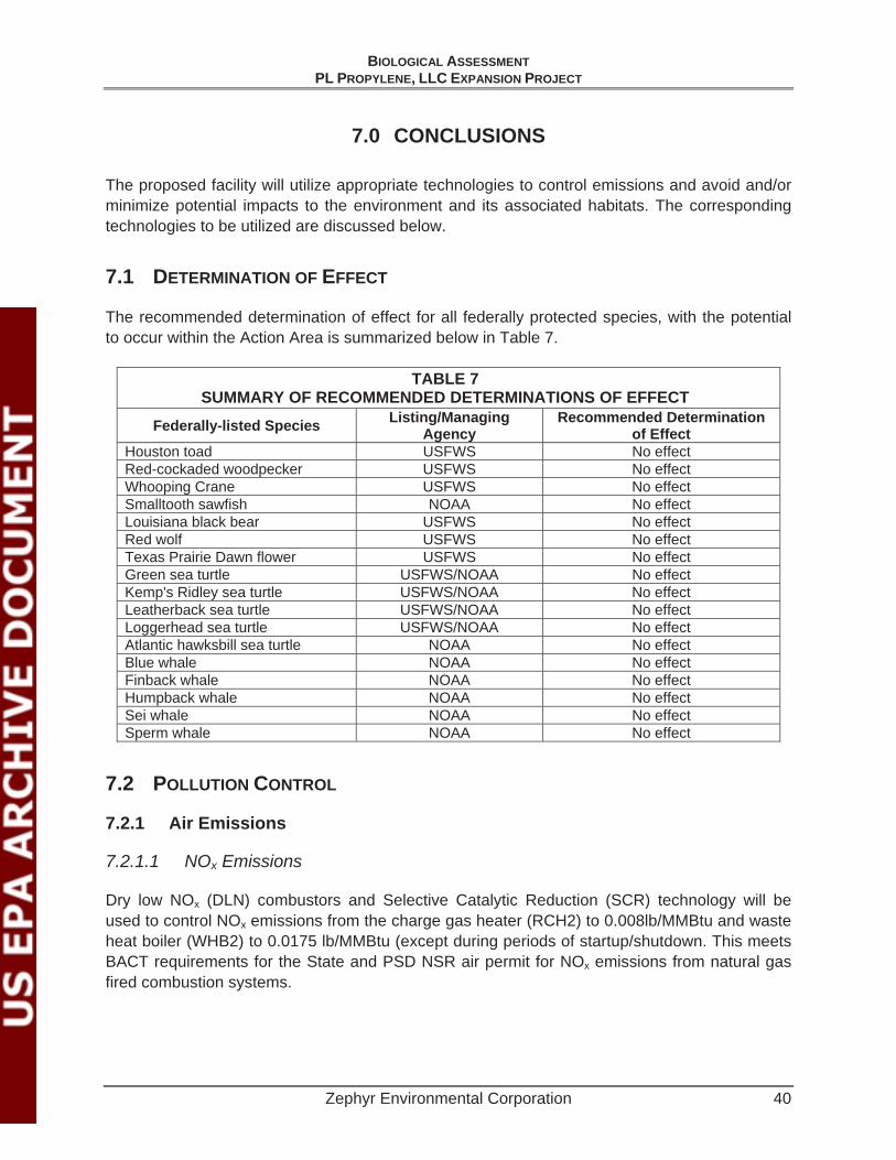
BIOLOGICAL ASSESSMENTPL PROPYLENE, LLC EXPANSION PROJECT
Zephyr Environmental Corporation 40
7.0 CONCLUSIONS
The proposed facility will utilize appropriate technologies to control emissions and avoid and/or minimize potential impacts to the environment and its associated habitats. The corresponding technologies to be utilized are discussed below.
7.1 DETERMINATION OF EFFECT
The recommended determination of effect for all federally protected species, with the potential to occur within the Action Area is summarized below in Table 7.
TABLE 7 SUMMARY OF RECOMMENDED DETERMINATIONS OF EFFECT
Federally-listed Species Listing/Managing Agency
Recommended Determination of Effect
Houston toad USFWS No effect Red-cockaded woodpecker USFWS No effect Whooping Crane USFWS No effect Smalltooth sawfish NOAA No effect Louisiana black bear USFWS No effect Red wolf USFWS No effect Texas Prairie Dawn flower USFWS No effect Green sea turtle USFWS/NOAA No effect Kemp's Ridley sea turtle USFWS/NOAA No effect Leatherback sea turtle USFWS/NOAA No effect Loggerhead sea turtle USFWS/NOAA No effect Atlantic hawksbill sea turtle NOAA No effect Blue whale NOAA No effect Finback whale NOAA No effect Humpback whale NOAA No effect Sei whale NOAA No effect Sperm whale NOAA No effect
7.2 POLLUTION CONTROL
7.2.1 Air Emissions
7.2.1.1 NOx Emissions
Dry low NOx (DLN) combustors and Selective Catalytic Reduction (SCR) technology will be used to control NOx emissions from the charge gas heater (RCH2) to 0.008lb/MMBtu and waste heat boiler (WHB2) to 0.0175 lb/MMBtu (except during periods of startup/shutdown. This meets BACT requirements for the State and PSD NSR air permit for NOx emissions from natural gas fired combustion systems.

BIOLOGICAL ASSESSMENTPL PROPYLENE, LLC EXPANSION PROJECT
Zephyr Environmental Corporation 41
7.2.1.2 CO Emissions
To control CO emissions, the WHB2 will be equipped with a catalytic oxidation system. With this operational measure, CO emissions associated with WHB2 should not exceed 50 ppmv at 15% O2 in the exhaust over a rolling 24-hour, excluding periods of startup, shutdown.
7.2.1.3 Volatile Organic Compound (VOC) Emissions
The use of natural gas and maintenance of optimum combustion conditions and practices is considered BACT for the control of VOC emissions from the combustion unit associated with this project. VOC emissions from WHB2 are designed to meet 1.75 ppmv at 15% O2 and 1.0 ppmv for a rolling 3-hour period for RCH2.
7.2.1.4 PM/PM10/PM2.5 Emissions
Because the combustion units will only fire gaseous fuel, PM/PM10/PM2.5 emissions are anticipated to be relatively low. The use of gaseous fuel and the application of good combustion controls meet BACT requirements for the air permit for PM/PM10/PM2.5 emissions from the combustion units.
7.2.1.5 Sulfur Compound Emissions
The formation of SO2, H2SO4 and (NH4)2SO4 will be minimized by using pipeline-quality natural gas with a sulfur content not exceeding 0.05 grains total sulfur per 100 scf The use of gaseous fuel meets BACT requirements for the air permit for SO2, H2SO4 and (NH4)2SO4 emissions from the combustion generator.
7.2.1.6 NH3 Emissions
PLP will operate the SCR systems in such a manner that ammonia (NH3) slip (i.e., the emission of unreacted ammonia to the atmosphere) is minimized while ensuring that the NOx emissions limits are met. Careful control of the ammonia injection system and operating parameters will be maintained to control ammonia slip in the WHB2 and RCH2 exhaust streams to levels not exceeding 7 ppmv at 15% O2 for WHB2 and 10 ppmv at 3% O2 This level of emissions control meets BACT requirements for the air permit for ammonia slip for gas fired combustion units.
7.2.1.7 Fugitive Emissions from Natural Gas and Ammonia Piping Components
To ensure that fugitive emissions from the piping components in ammonia service are adequately controlled, PLP will follow an audio, visual, and olfactory (AVO) inspection and maintenance program, performing periodic inspections supplemented by annual remote optical sensing. These measures meet BACT requirements for the air permit for VOC and ammonia emissions from piping components.
BIOLOGICAL ASSESSMENTPL PROPYLENE, LLC EXPANSION PROJECT
Zephyr Environmental Corporation 42
7.2.2 Wastewater and Storm Water
7.2.2.1 Mitigation of Construction Related Impacts to Surface Water
During construction of the proposed additions to the p, PLP will follow the TCEQ requirement to obtain a construction storm water permit for the proposed project. The site will employ best management practices to prevent contamination due to storm water runoff, including erosion control and stabilization, minimization of offsite vehicle tracking and dust generation, and other practices as warranted by site specific conditions. The site will also follow the notification, recordkeeping, and reporting requirements of TCEQ’s construction storm water management program.
7.2.2.2 Mitigation of Operational Impacts to Surface Water
Since there is a discharge of wastewater to the surface waters of Texas, a Texas Pollutant Discharge Elimination System (TPDES) was required. The plant will continue to operate under its existing TPDES permit after the modification. During construction of the proposed facility, PLP will follow the TCEQ requirement to obtain a construction storm water permit for the proposed project. The site will employ best management practices to prevent contamination due to storm water runoff, including erosion control and stabilization, minimization of offsite vehicle tracking and dust generation, and other practices as warranted by site. The site will also follow the notification, recordkeeping, and reporting requirements of TCEQ’s construction storm water management program.
The proposed increase in effluent discharge volume is not expected to have a higher concentration of pollutants than the current discharge and therefore, would not have an adverse effect on the receiving water, or wildlife in the area. Discharge at Outfall 001 would have a favorable effect to water quality of the receiving stream (Sims Bayou).
The PLP facility will have an Oil and Hazardous Materials Spill Prevention, Control, and Countermeasure Plan and Storm Water Pollution Prevention Plan in place prior to operation and the facility employees will be trained to implement these plans. These plans will be utilized during operations, and maintenance of the proposed additional combustion sources.

BIOLOGICAL ASSESSMENTPL PROPYLENE, LLC EXPANSION PROJECT
Zephyr Environmental Corporation 43
8.0 LITERATURE CITED
Correll, D. S. and M. C. Johnston. 1970. Manual of the vascular plants of Texas. Texas Research Station. Renner, Texas.
Dudley, N. and Stolton, S. 1996. Air Pollution and Biodiversity: A Review. World Wildlife Fund, International (WWF), Switzerland.
Dwyer FJ, Mayer FL, Sappington LC, Buckler DR, Bridges CM, Greer IE et al. (2004) Assessing Contaminant Sensitivity Of Endangered And Threatened Aquatic Species: 1. Archives of Environmental Contamination Toxicology, 48, 143–154 (2005) DOI: 10.1007/s00244-003-3038-1
Lovett GM and Tear TH. 2008. Threats from Above, Air Pollution Impacts on Ecosystems and Biological Diversity in the Eastern United States. Institute of Ecosystem Studies and The Nature Conservancy.
Mayer, Foster L., Denny R. Buckler, F. James Dwyer, Mark R. Ellersieck, Linda C. Sappington, John M. Besser and Christine M. Bridges. 2008. Endangered Aquatic Vertebrates: Comparative And Probabilistic-Based Toxicology. EPA/600/R-08/045. U.S. Environmental Protection Agency, Office of Research and Development, Washington DC. 33p. (ERL,GB X1109).
National Oceanic and Atmospheric Administration (NOAA). Endangered and Threatened Species and Critical Habitats under the Jurisdiction of the NOAA Fisheries Service http://sero.nmfs.noaa.gov/pr/endangered%20species/specieslist/PDF2012/Texas.pdf accessed 8/2/12.
National Oceanic and Atmospheric Administration(c) – Office of Protected Resources, Green Turtle (Chelonia mydas), http://www.nmfs.noaa.gov/pr/species/turtles/green.htm,Accessed July 20, 2012 – Green Sea Turtle.
National Oceanic and Atmospheric Administration(d) – Office of Protected Resources, Kemp's Ridley Turtle (Lepidochelys kempii), http://www.nmfs.noaa.gov/pr/species/turtles/kempsridley.htm, Accessed July 20, 2012 – Kemps Ridley Sea Turtle.
National Oceanic and Atmospheric Administration(e) – Office of Protected Resources, Leatherback Turtle (Dermochelys coriacea), http://www.nmfs.noaa.gov/pr/species/turtles/leatherback.htm, Accessed July 20, 2012.
National Oceanic and Atmospheric Administration(f) – Office of Protected Resources, Loggerhead Turtle (Caretta caretta), http://www.nmfs.noaa.gov/pr/species/turtles/loggerhead.htm, Accessed July 20, 2012.
National Weather Service- Advanced Hydrologic Prediction Service (NWS-AHPS) 2012. In Texas: June, 2012 http://water.weather.gov/precip/ Accessed August 8, 2012.

BIOLOGICAL ASSESSMENT PL PROPYLENE, LLC EXPANSION PROJECT
Zephyr Environmental Corporation 44
Port of Houston Authority (POH) 2012. In About Us-History. Retrieved July 26, 2012 from http://www.portofhouston.com/about-us/history/
Redwine, J.S., Lacey, R. E., Mukhtar, S., and Carey, J. B. 2002. Concentration and Emissions of Ammonia and Particulate Matter in Tunnel- Ventilated Broiler Houses Under Summer Conditions in Texas. American Society of Agricultural Engineers. Volume 45(4) p. 1101-1109. ISSN 0001-2351.
Sappington LC, Mayer FL, Dwyer FJ, Buckler DR, Jones JR, Ellersieck MR (2001) Contaminant Sensitivity Of Threatened And Endangered Fishes Compared To Standard Surrogate Species. Environmental Toxicology and Chemistry, 20:2869–2876
Smith AE and Levenson JB. 1980. A Screening Procedure for the Impacts of Air Pollution on Plants, Soils, and Animals. Argonne National Laboratory, Argonne, Illinois, USA.
Texas Parks and Wildlife Department - Texas Natural Diversity Database, 2012. Request to Bob Gottfried- TXNDD Administrator for Harris County. ESRI Shapefile - May 4, 2012.
Texas Parks and Wildlife Department (TPWD) 2012. Annotated County Lists of Rare Species – Harris County. http://www.tpwd.state.tx.us/gis/ris/es/ES_Reports.aspx?county=Harris Accessed July 28, 2012.
Texas Parks and Wildlife Department(f), 2011. Texas Prairie Dawn. http://www.tpwd.state.tx.us/huntwild/wild/species/endang/plants/txprdawn.phtml. Accessed July 9, 2012.
Texas State Historical Association, 2012. Margaret Swett Henson, "HARRIS COUNTY," Handbook of Texas Online (http://www.tshaonline.org/handbook/online/articles/hch07), accessed July 23, 2012.
Texas Water Development Board, http://www.tpwd.state.tx.us/huntwild/wild/species/htoad/. Houston toad (Bufo houstonensis) Accessed August 10, 2012.
Tveten, J. and G. Tveten. Wildflowers of Houston and Southeast Texas. University of Texas Press. Austin, Texas, 1993.
U. S. Drought Monitor (USDM). In U.S. Drought Monitor- Texas. Accessed August 8, 2012. http://droughtmonitor.unl.edu/DM_state.htm?TX,S., 2012.
U.S. Department of Agriculture (USDA), Soil Survey, 1976, Harris County, Texas
U.S. Fish and Wildlife Service (USFWS) – Texas Prairie Dawn - 1989. Hymenoxys texana recovery plan. Albuquerque, New Mexico, USA.
U.S. Fish and Wildlife Service (USFWS), 2003. Recovery Plan for the Red-cockaded Woodpecker (Picoides borealis) – Second Revision. USFWS-Southeast Region. Atlanta, Georgia, USA.
BIOLOGICAL ASSESSMENT PL PROPYLENE, LLC EXPANSION PROJECT
Zephyr Environmental Corporation 45
U.S. Fish and Wildlife Service (USFWS), 2012. Houston Toad 5 – Year Review: Summary and Evaluation. http://ecos.fws.gov/docs/five_year_review/doc3958.pdf. Accessed August 1, 2012.
U.S. Fish and Wildlife Service (USFWS), 2012. 2007. Whooping crane (Grus americana) international recovery plan. http://ecos.fws.gov/docs/recovery_plans/2007/050111.pdf Accessed July 2008 Accessed August 13, 2012.
U.S. Geological Survey (USGS), 7.5 Minute Topographic Maps – Park Place and Pasadena Quadrants
Zimmerman, Roger. 2012. Personal Communication with Clay V. Fischer. June 15, 2012.

BIOLOGICAL ASSESSMENTPL PROPYLENE, LLC EXPANSION PROJECT
Zephyr Environmental Corporation 46
9.0 LIST OF PREPARERS
Vance Darr, P.E., Environmental Engineer, PL Propylene, LLC
Edward G. Fiesinger, P.E., Principal, Zephyr Environmental Corporation
Robert Fisher, Natural Resources Scientist, Zephyr Environmental Corporation
William B. Jones, Senior Project Manager, Zephyr Environmental Corporation
Jennifer N. Knowles, Staff Scientist, Zephyr Environmental Corporation
Steven R. McVey, P.G., Principal, Zephyr Environmental Corporation
David H. Sorrells, P.E., Senior Project Engineer, Zephyr Environmental Corporation

BIOLOGICAL ASSESSMENTPL PROPYLENE, LLC EXPANSION PROJECT
Zephyr Environmental Corporation
APPENDIX A FIGURES

PL Propylene, LLC
K:\PL Propylene LLC\Draft BA\Figures
Drafted By:J. Knowles
Date:09/10/2012
Project No.:011377
Reviewed By:R. Fisher
Datum: GCS NAD 1983, UTM Zone 15Map Sources: ESRI Bing HybridBasemap & Streets Basemap;PL Propylene, LLC
!( Harris County, TexasSITE LOCATION
Harris County
PL Propylene, LLC
0 2.5 5Miles
0 2.5 5Kilometers
1 inch = 8,333 feet1:100,000Scale
qProperty Boundary
FIGURE 3-1: PROJECT LOCATION
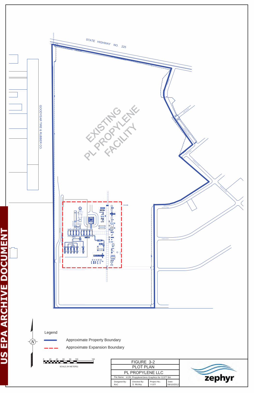
3-2
09/10/2012S. McVey
H:\PL Propylene\Jens Graphics for 11377 BA
EXISTIN
G
PL PROPYLE
NE
FACILI
TY
Legend
Approximate Property Boundary
Approximate Expansion Boundary

PL Propylene, LLC
H:\PL Propylene\..11377 BA\11377 PL Propylene Section 5\BA Figures
Drafted By:J. Knowles
Date:03.29.2013
Project No.:011377
Reviewed By:S. McVey
Datum: GCS NAD 1983, UTM Zone 15Map Sources: ESRI Bing HybridBasemap & Streets Basemap;PL Propylene, LLC
Copyright:© 2012 Esri, DeLorme, NAVTEQ, TomTom, Source: Esri,DigitalGlobe, GeoEye, i-cubed, USDA, USGS, AEX, Getmapping, Aerogrid,IGN, IGP, and the GIS User Community
!(
FIGURE 4-1: ACTION AREA
Harris County, Texas
Sources: Esri, DeLorme,NAVTEQ, USGS, Intermap,iPC, NRCAN, Esri Japan,METI, Esri China (Hong
SITE LOCATION
Harris County
PL Propylene, LLC
Property BoundaryExpansion SiteAction Area
_̂Wastewater Outfall 0 0.5 1Miles
0 0.5 1Kilometers
1:24,000Scale
q

PL Propylene, LLC
H:\PL Propylene\...11377 BA\11377 PL Propylene Section 5\BA Figures
Drafted By:J. Knowles
Date:03.29.2013
Project No.:011377
Reviewed By:S. McVey
!( Harris County, Texas
Sources: Esri, DeLorme,NAVTEQ, USGS, Intermap,iPC, NRCAN, Esri Japan,METI, Esri China (Hong
SITE LOCATION
Harris County
PL Propylene, LLC
Property BoundaryExpansion SiteAction Area
_̂ Wastewater Outfall
LANDUSECropland and pastureIndustrialResidentialTransportation & communications
FIGURE 5-1: LAND USE Datum: GCS NAD 1983, UTM Zone 15
Map Sources: ESRI Bing HybridBasemap & Streets Basemap;PL Propylene, LLC
Houston Ship Channel
Sims Bayou
q 0 0.5 1Miles
0 0.5 1Kilometers
1:24,000Scale

PL Propylene, LLC
H:\PL Propylene\..11377 BA\11377 PL Propylene Section 5\BA Figures
Drafted By:J. Knowles
Date:03.29.2013
Project No.:011377
Reviewed By:S. McVey
!( Harris County, Texas
Sources: Esri, DeLorme,NAVTEQ, USGS, Intermap,iPC, NRCAN, Esri Japan,METI, Esri China (Hong
SITE LOCATION
Harris County
PL Propylene, LLC
Property BoundaryExpansion SiteAction Area
_̂ Wastewater Outfall
FEMA Flood Zone Designation0.2% annual chanceA- 1% annual chance AE- Base floodplainX- Areas outside floodplain
FIGURE 5-2: FEMA ZONES
Datum: GCS NAD 1983, UTM Zone 15Map Sources: ESRI Bing HybridBasemap & Streets Basemap;Houston-Galveston Area Council PL Propylene, LLC
Houston Ship Channel
Sims Bayou
q 0 0.5 1Miles
0 0.5 1Kilometers
1:24,000Scale

PL Propylene, LLC
H:\PL Propylene\...11377 BA\11377 PL Propylene Section 5\BA Figures
Drafted By:J. Knowles
Date:03.29.2013
Project No.:011377
Reviewed By:S. McVey
!( Harris County, Texas
Sources: Esri, DeLorme,NAVTEQ, USGS, Intermap,iPC, NRCAN, Esri Japan,METI, Esri China (Hong
SITE LOCATION
Harris County
PL Propylene, LLC
Property BoundaryExpansion SiteAction Area
_̂ Wastewater Outfall
Geologic UnitsQbc - Beaumont ClayWater
Datum: GCS NAD 1983, UTM Zone 15Map Sources: ESRI Bing HybridBasemap & Streets Basemap;Geologic Atlas of TexasPL Propylene, LLC
FIGURE 5-3: GEOLOGY
Houston Ship Channel
Sims Bayou
q 0 0.5 1Miles
0 0.5 1Kilometers
1:24,000Scale
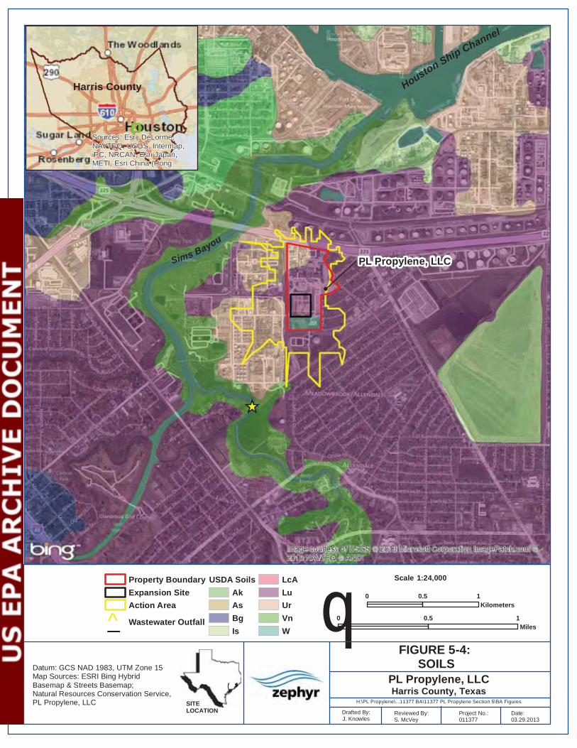
PL Propylene, LLC
H:\PL Propylene\...11377 BA\11377 PL Propylene Section 5\BA Figures
Drafted By:J. Knowles
Date:03.29.2013
Project No.:011377
Reviewed By:S. McVey
!( Harris County, Texas
Sources: Esri, DeLorme,NAVTEQ, USGS, Intermap,iPC, NRCAN, Esri Japan,METI, Esri China (Hong
SITE LOCATION
Harris County
PL Propylene, LLC
Property BoundaryExpansion SiteAction Area
_̂ Wastewater Outfall
USDA SoilsAkAsBgIs
LcALuUrVnW
FIGURE 5-4: SOILSDatum: GCS NAD 1983, UTM Zone 15
Map Sources: ESRI Bing HybridBasemap & Streets Basemap;Natural Resources Conservation Service,PL Propylene, LLC
Houston Ship Channel
Sims Bayou
q 0 0.5 1Miles
0 0.5 1Kilometers
1:24,000Scale

PL Propylene, LLC
H:\PL Propylene\Jens Graphics for 11377 BA\11377 PL Propylene Section 5\BA Figures
Drafted By:J. Knowles
Date:03.29.2013
Project No.:011377
Reviewed By:S. McVey
!(
FIGURE 5-5: Wetlands Map
Harris County, Texas
Sources: Esri, DeLorme,NAVTEQ, USGS, Intermap,iPC, NRCAN, Esri Japan,METI, Esri China (Hong
SITE LOCATION
Harris County
PL Propylene, LLC
Property BoundaryExpansion SiteAction Area
_̂ Wastewater Outfall
NWI Wetlands
Estuarine and Marine DeepwaterFreshwater Emergent WetlandFreshwater Forested/Shrub WetlandFreshwater PondLakeRiverine
Datum: GCS NAD 1983, UTM Zone 15Map Sources: ESRI Bing HybridBasemap & Streets Basemap;USFWS- National Wetlands InventoryPL Propylene, LLC
Houston Ship Channel
Sims Bayou
q 0 0.5 1Miles
0 0.5 1Kilometers
1:24,000Scale

BIOLOGICAL ASSESSMENTPL PROPYLENE, LLC EXPANSION PROJECT
Zephyr Environmental Corporation
APPENDIX B SITE PHOTOGRAPHS
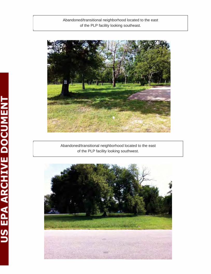
Abandoned/transitional neighborhood located to the eastof the PLP facility looking southeast.
Abandoned/transitional neighborhood located to the eastof the PLP facility looking southwest.
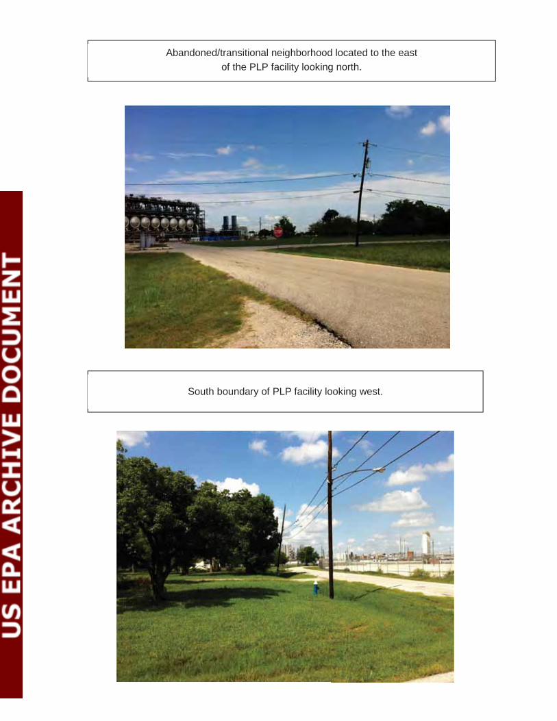
Abandoned/transitional neighborhood located to the eastof the PLP facility looking north.
South boundary of PLP facility looking west.

Southeast boundary of PLP facility looking northwest.
Residential neighborhood south of the PLP Facility looking west.
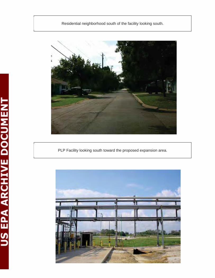
Residential neighborhood south of the facility looking south.
PLP Facility looking south toward the proposed expansion area.

PLP facility looking southeast toward the proposed expansion area.
PLP facility looking east toward the property boundary.

PLP Facility looking northeast toward the existing facility and property boundary.
PLP Facility looking southwest toward the property boundary and Goodyear facility.

PLP Facility looking west toward the property boundary and Goodyear facility.
PLP Facility looking north toward boundary and SH225.

BIOLOGICAL ASSESSMENTPL PROPYLENE, LLC EXPANSION PROJECT
Zephyr Environmental Corporation
APPENDIX C FIELD SURVEY DATA SUMMARY

BIOLOGICAL ASSESSMENT PL PROPYLENE, LLC EXPANSION PROJECT
ZEPHYR ENVIRONMENTAL CORPORATION
Site inspection of PL Propylene Action Area Surveyor: Robert Fisher July 26, 2012 Weather: High temperature 96°F, Average humidity 68%, clear, wind speed 5 - 18 mph, no rain On July 26, 2012, Zephyr performed a windshield and pedestrian survey of the PL Propylene Action Area. The purpose of the survey was to observe as much of the Action Area as possible to gain further knowledge of the regional setting within and surrounding the PL Propylene facility. The survey included threatened and endangered species and habitats, land use (Appendix A), and any other sensitive receptors that could be located within the Action Area. Appendix B includes photos and a photo log of the representative areas that were observed. The survey started with a tour of the PL Propylene facility. This tour included all existing operations as well as the locations where the proposed construction activities will occur. After visiting the facility, Zephyr continued the remaining survey going from the east, south, west and north within the Action Area. The Action Area is dominated primarily by industrial services and residential neighborhoods. A portion of the Action Area to the east is relatively undeveloped and appears to be a transitioning neighborhood where mostly empty lots/foundations and a few homes or small businesses are located. South of the PLP facility within the Action Area is a residential neighborhood. Directly west of the facility is a Goodyear manufacturing facility/plant. North of the facility is SH 225. TERRESTRIAL FAUNA Within the Action Area, the survey did not reveal any significant or sensitive wildlife habitats. Due to the land use in the area, most naturally occurring or historic habitat types have been converted to residential and industrial uses. When observing the vegetation and habitat types within the Action Area, it was determined that none of the listed threatened or endangered species would be within the Action Area due to lack of habitat or even potential habitat. The Texas Natural Diversity Database (TXNDD) also showed that none of the protected species have been observed within the Action Area. Although none of the sensitive species or habitat was observed, residential areas and even some industrial areas still provide ideal conditions for other species. Typical wildlife observed or known to inhabit conditions within the Action area includes:
Grackles White wing dove Mourning dove Red tailed hawk
Turkey vulture American Crow Mocking birds Rock pigeon
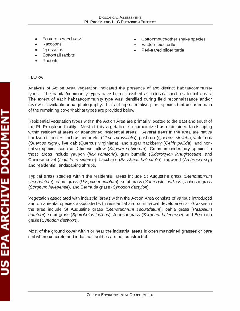
BIOLOGICAL ASSESSMENT PL PROPYLENE, LLC EXPANSION PROJECT
ZEPHYR ENVIRONMENTAL CORPORATION
Eastern screech-owl Raccoons Opossums Cottontail rabbits Rodents
Cottonmouth/other snake species Eastern box turtle Red-eared slider turtle
FLORA Analysis of Action Area vegetation indicated the presence of two distinct habitat/community types. The habitat/community types have been classified as industrial and residential areas. The extent of each habitat/community type was identified during field reconnaissance and/or review of available aerial photography. Lists of representative plant species that occur in each of the remaining cover/habitat types are provided below. Residential vegetation types within the Action Area are primarily located to the east and south of the PL Propylene facility. Most of this vegetation is characterized as maintained landscaping within residential areas or abandoned residential areas. Several trees in the area are native hardwood species such as cedar elm (Ulmus crassifolia), post oak (Quercus stellata), water oak (Quercus nigra), live oak (Quercus virginiana), and sugar hackberry (Celtis pallida), and non-native species such as Chinese tallow (Sapium sebiferum). Common understory species in these areas include yaupon (Ilex vomitoria), gum bumelia (Sideroxylon lanuginosum), and Chinese privet (Ligustrum sinense), baccharis (Baccharis halimifolia), ragweed (Ambrosia spp) and residential landscaping shrubs. Typical grass species within the residential areas include St Augustine grass (Stenotaphrum secundatum), bahia grass (Paspalum notatum), smut grass (Sporobulus indicus), Johnsongrass (Sorghum halepense), and Bermuda grass (Cynodon dactylon). Vegetation associated with industrial areas within the Action Area consists of various introduced and ornamental species associated with residential and commercial developments. Grasses in the area include St Augustine grass (Stenotaphrum secundatum), bahia grass (Paspalum notatum), smut grass (Sporobulus indicus), Johnsongrass (Sorghum halepense), and Bermuda grass (Cynodon dactylon). Most of the ground cover within or near the industrial areas is open maintained grasses or bare soil where concrete and industrial facilities are not constructed.


