58
Planning Act 2008 The Network Rail (Ordsall Chord) Order Section 42 Consultation Pack November 2012 Network Rail Infrastructure Limited Kings Place 90 York Way London N1 9AG

Planning Act 2008
The Network Rail (Ordsall Chord) Order
Section 42 Consultation Pack November 2012
Network Rail Infrastructure Limited Kings Place 90 York Way London N1 9AG

[this page left intentionally blank]

CONTENTS
1.0 INTRODUCTION 5
2.0 BACKGROUND TO THE ORDSALL CHORD 7
2.2 PROPOSED DEVELOPMENT SITE 8
2.3 DESCRIPTION OF THE DEVELOPMENT 9
3.0 EVOLUTION OF THE ORDSALL CHORD AND HOW NETWORK RAIL ARRIVED AT ITS PROPOSED ALIGNMENT 10
4.0 ACHIEVING HIGH QUALITY DESIGN 16
5.0 THE IMPORTANCE OF THE BUILT HERITAGE 30
6.0 SAFEGUARDING OUR ENVIRONMENT 34
7.0 CONNECTING SALFORD AND MANCHESTER 36
8.0 CONSTRUCTING THE ORDSALL CHORD 39
9.0 PROGRAMME AND NEXT STEPS 47
9.3 PUBLIC CONSULTATION 47
APPENDICES 49
APPENDIX A: LOCATION PLAN 50
APPENDIX B: INITIAL ALIGNMENT OPTIONS 51
APPENDIX C: PREFERRED ALIGNMENT 52
APPENDIX D: CONSTRAINTS PLAN 53
APPENDIX E: UPDATE ON PRELIMINARY ENVIRONMENTAL INFORMATION 54
page 1 of 56

APPENDIX F: REPLACEMENT PEDESTRIAN AND CYCLE BRIDGE LOCATION 55
APPENDIX G: OPTIONS TO DIVERT UTILITIES 56
APPENDIX H: COMPOUND LOCATIONS AND STRATEGIC CONSTRUCTION ROUTES 57
APPENDIX I: TEMPORARY AND PERMANENT LAND PLANS 58
page 2 of 56

1.0 Introduction
1.1 The Ordsall Chord
1.1.1 Network Rail will be making a Development Consent Order (DCO)
application to the Planning Inspectorate to gain the necessary powers
to construct a new piece of railway over the River Irwell in the area of
the Museum of Science and Industry and Salford Central Station.
1.1.2 The scheme, known as the Ordsall Chord, will provide a direct rail link
between the three main stations in Manchester (Victoria, Oxford Road
and Piccadilly). It will allow for the future expansion of Salford Central
station and enable trains from the east of England to reach Manchester
Airport without crossing the West Coast Main Line to the south of
Manchester Piccadilly.
1.1.3 This will help remove a key rail bottleneck in the area. The benefits of
the Ordsall Chord are:
Two new fast trains per hour between Manchester Victoria and
Liverpool;
Six fast trains an hour between Leeds and Manchester (as opposed
to four now);
Faster journeys across the north:
o Journey times between Leeds and Manchester could be
reduced by about 10 minutes
o Journey times between Liverpool and Manchester could be
reduced by 10-15 minutes
A new direct service through Manchester city centre to Manchester
Airport; and
Faster journey times to Hull, Newcastle and the North East.
1.1.4 As part of the Development Consent Order process, Network Rail is
consulting on the Ordsall Chord project. The purpose of this
page 3 of 56

consultation is to provide stakeholders with information about the
emerging plans and gather feedback on:
A proposed railway alignment which crosses Water Street,
Manchester, the River Irwell and Trinity Way in Salford;
Two bridge and viaduct design options for the new railway; and
A potential location for a replacement pedestrian and cycle bridge
across the River Irwell.
1.1.5 Technical consultation (Section 42 of the Planning Act 2008) and public
consultation (Section 47 of the Planning Act 2008) started in October
2011. This round of consultation provided an opportunity to share high
level information about the emerging plans with interested parties. Over
the past year, Network Rail has continued to engage with consultees to
develop the scheme. Network Rail set up a Working Party to engage
the two local authorities within the boundary of the application site
(Manchester and Salford City Councils), English Heritage and
Transport for Greater Manchester. Network Rail prepared a protocol for
the Working Party, which set out a remit, roles and responsibilities. The
Working Party has been an integrated part of the design development
process since January 2012.
1.1.6 This document provides an overview of the latest plans for the
proposed Ordsall Chord. The scheme is still being designed and further
consultation will be undertaken ahead of submission of the application
to the Planning Inspectorate.
page 4 of 56
2.0 Background to the Ordsall Chord
2.1 The Northern Hub
2.1.1 The last decade has seen a transformation in rail across the North of
England. Hundreds more trains now run every day and they are safer
and more reliable than ever before.
2.1.2 Commuter passenger numbers are increasing with forecasts showing
that demand for peak time rail services into Manchester is expected to
grow 37% by 2019. A new railway chord at Ordsall will help to
accommodate this demand and support economic growth in the North
of England. Fast and reliable links between the North’s city regions and
international gateways such as Manchester Airport are seen as an
essential part of supporting economic growth in jobs and businesses.
2.1.3 Ordsall Chord is a major project in its own right delivering capacity
improvements across the region. Set within a wider context, it is the
first part of the Northern Hub, a £560million programme of works to
stimulate economic growth and transform the rail network in the North
of England. The Chancellor of the Exchequer, George Osborne,
announced £85m of funding for the Ordsall Chord project in 2011. This
was followed by the Government’s High Level Output Statement
announcement in Summer 2012 to fund the entire Northern Hub
project.
2.1.4 The Northern Hub is projected to deliver:
over £4bn worth of wider economic benefits to the region and
potentially 20,000 to 30,000 new jobs;
an improved rail network that will allow us to double the capacity of
trains into the Trafford Park freight terminals; and
a £4 boost to the economy for every £1 spent.
page 5 of 56

2.1.5 For further information:
http://www.networkrail.co.uk/improvements/northern-hub/
2.2 Proposed Development Site
2.2.1 The site lies within an urban area on the edge of Manchester City
Centre and crosses the River Irwell into Salford and centres on Grid
Reference SJ 382891 97950. The site is bounded by existing railways
to the south, north and west (see Figure 1 below and Appendix A).
Figure 1: Location Plan
page 6 of 56

2.3 Description of the Development
2.3.1 The new two-track railway, the Ordsall Chord, will connect the
Castlefield Junction line with the Deal Street Junction line. It will cross:
Water Street, Manchester;
the railway viaduct connection to the Museum of Science and
Industry (MoSI);
the River Irwell, and;
the Manchester and Salford Inner Relief Road (Trinity Way A6042)
in Salford.
2.3.2 It will then run parallel with the existing line between Ordsall Lane
Junction and Manchester Victoria, before connecting with it south of
Salford Central station.
2.3.3 The new railway will be electrified and have a maximum line speed of
30mph, providing a consistent line speed between Manchester
Piccadilly and Manchester Victoria. It will allow trains to run directly
between Manchester Victoria, Oxford Road and Piccadilly without
needing to reverse.
page 7 of 56

3.0 Evolution of the Ordsall Chord and how Network Rail arrived at its
proposed alignment
3.1 Introduction
3.1.1 The Ordsall Chord has evolved through a consultative design
development process. To summarise:
Network Rail and its industry partners sought to identify and
compare high level strategic options at Manchester Victoria and
Manchester Piccadilly to deliver the specified project requirements.
Network Rail then considered local options for a connection in the
Ordsall Lane junction area before assessing each option’s suitability
and viability. This phase formed the detail of the consultation
carried out in October 2011;
Following consultation, detailed review of potential rail alignment
options was carried out, a new alignment was developed in
response to key concerns from stakeholders; and
The development of bridge and viaduct designs and an assessment
of all environmental impacts and identification of mitigation
measures.
3.1.2. The Ordsall Chord proposal currently consists of a preferred railway
alignment and two potential bridge/viaduct design options that could be
built. Following this round of consultation, a preferred design will be
chosen and this will be followed by a final round of consultation then a
Development Consent Order application. This is expected to be
submitted to the Planning Inspectorate in Summer 2013.
page 8 of 56

3.2 Option Assessment: Strategic Options
3.2.1 Two main strategic options were identified and assessed. One was the
Piccadilly option and the other was the Victoria Option.
3.2.2 The Piccadilly Option proposed a flyover which would extend over the
existing rail line connections at Ardwick to the east of Piccadilly Station.
3.2.3 The Victoria option proposed the Ordsall Chord which would balance
rail services between Victoria and Piccadilly Stations by allowing trains
approaching from the east to be diverted to the north towards Victoria
Station.
3.2.4 A number of different interventions make up each strategic option but
the key driver was how to deal with the conflicting train movements at
Piccadilly Station which significantly affect capacity on the rail network.
3.2.5 The criteria used to assess the strategic options were:
performance against the conditional outputs;
train performance;
disruption during construction and after commissioning;
opportunities for timing of their implementation;
impact of New Lines/High Speed 2;
value for money; and
affordability.
3.2.6 How well the options delivered against the criteria was assessed by a
combination of a qualitative assessment, achievement against the
conditional outputs and an economic appraisal.
3.2.7 The assessment concluded that of these two strategic options, the
Victoria option performed significantly better than the Piccadilly option.
Further information about these strategic options and the assessment
page 9 of 56

of them can be read in full by using the following link to page 56 of the
Manchester Hub Rail Study (see:
http://www.networkrail.co.uk/aspx/6474.aspx)
3.3 Local Options
3.3.1 Once Network Rail and its industry partners made the decision to
progress the Victoria strategic option, the second stage of work
commenced which explored different local options. These included
long and short flyover options, tunnel options and an option for a new
section of track at the same height as the current railway lines.
3.3.2 An assessment of the options was then undertaken. The option to build
a new section of track at the same height as the current railway lines at
Ordsall Chord was chosen to proceed to the next stage of design
development. This would provide a direct rail link between the existing
Middlewood and Castlefield Railway Viaducts in the Ordsall Lane
junction area, crossing over the Museum of Science and Industry
mainline connection.
3.3.3 The remaining options were appraised and dismissed for various
reasons. Plans of the three options summarised below are shown in
Appendix B.
Short Chord Flyover Option - it was not possible to accommodate
this option between the Altrincham Metrolink line and connect it into
the Middlewood Railway Viaduct without resulting in significant
modifications to the existing railway lines and the adjacent highway
infrastructure. These modifications would require the closure of the
rail network for a significant period during construction, resulting in
disruption to the existing public transport system.
page 10 of 56

A second short chord option was considered which extends over
Trinity Way and the Middlewood Viaduct. However, this alignment
would have a significant impact on several large regeneration sites
identified for development, would not represent value for money
and would not provide gradients for any freight/engineering
activities required.
Long Chord Flyover Option – this option differs from the short
chord flyover as it proposes to go over the existing Altrincham
Metrolink (Cornbrook Viaduct) line. Again, due to the shallow
gradients and the height required to clear existing Metrolink
structures, this option would extend across the city centre between
Victoria and Piccadilly Stations and comprise a series of significant
viaducts and bridges which would be visible across the Manchester
skyline.
This option was considered to have a significant environmental
impact, require compulsory purchase of a substantial amount of
land, and, when compared to the other options, would not represent
value for money.
Tunnel Option – a tunnel option would have only a minimal impact
on the area around the application site when compared with all
other options. However, because of the shallow gradients required
for a railway, the majority of the structure would remain above
ground along its length. One tunnel alignment considered involved
the stopping up of approximately eight major roads serving the city
centre, including Oxford Road and would necessitate the diversion
of the River Medlock. These tunnel options were considered to
have a significant environmental impact, require compulsory
purchase of a substantial amount of land, and when compared to
the other options would not represent value for money
page 11 of 56

3.4 Railway Alignment Options
3.4.1 The next part of design development comprised a detailed review of all
potential alignment options for Ordsall Chord. Each alignment would
need to be of a suitable length to allow for a six car passenger train to
stop between the two new railway junctions that would be formed by
the new railway. The route would also need to be designed as to not
preclude any future freight traffic.
3.4.2 In total, 14 alignment options were developed, each with different
connection points and radii. The three shortlisted alignment options
are shown in Appendix C. In all of these three options, the proposed
chord would be at a similar height to the existing elevated railway
viaducts. It would be supported on modified existing structures or new
structures crossing over the River Irwell, Manchester Bolton & Bury
Canal, Prince’s Bridge and Trinity Way.
3.4.3 The development will extend through an area which has significant
heritage value with a collection of Grade I and II listed structures,
including the Grade I listed Stephenson’s Bridge which extends across
the River Irwell (see Appendix D). The relationship of the Ordsall
Chord to these heritage structures was a key consideration in the
development of these alignment options, as was the potential impact
on local residents and businesses.
3.4.4 The analysis of options and consultation with the key consultees
resulted in Network Rail choosing to proceed with an option which
would avoid any direct impact on the Grade I listed Stephenson’s
sandstone bridge. While the proposal will still have a direct impact on
several Grade II listed structures no engineering solutions have been
identified which overcome these impacts. It is this alignment which is
currently being consulted upon (see Appendix C).
page 12 of 56

3.4.5 The alignment options for the Ordsall Chord have placed a serious
constraint on the Museum of Science and Industry’s (MoSI) current
railway operations. Discussions with the Museum remain ongoing to
determine the optimum solution.
3.5 Integration and Coordination
3.5.1 To develop the proposals there is a need to bring together the
functional needs and aspirations of a wide range of stakeholders:
These include individuals and groups outside of the rail industry
including local government planning and highways authorities and
regeneration teams, statutory bodies (such as English Heritage and
the Environment Agency), those developing masterplans and
development proposals in and around the site and important
neighbouring bodies (Museum of Science & Industry, the Canal &
River Trust (formerly British Waterways Board));
The technical requirements of railway operations also must be
incorporated, including (amongst others) network service provision,
civil engineering, roads design, track design, overhead line
equipment (electrical supplies), signalling, maintenance, utilities and
plant equipment; and
These diverse needs must be integrated together with urban
planning, architectural, property, environment and heritage issues,
underpinned with a strong sustainability agenda.
page 13 of 56

4.0 Achieving High Quality Design
4.1 Ordsall Chord Design Principles
4.1.1 Network Rail has appointed an architectural team to lead the design of
the Ordsall Chord alignment and structural form options. Through
dialogue and consideration of the urban context, the team has
developed a manifesto of ten principles that underpin the design
approach to the Ordsall Chord. These are:
Within the Northern Hub, no other infrastructure intervention has a
similar functional, aesthetic or aspirational importance
The historic location on is one of the most sensitive sites in the
global evolution of the railway
The values of the site and structures should inform and enrich the
design process
Understandable concerns how new structures will impact on old
This location is ideal for the insertion of new rail infrastructure, with
the next layer of rail use overlaid on the history of the site
An agenda for the holistic design quality of the new structures is
critical to the success of the project
Statutory approvals process is important in the immediate future
Equally so is the long-term legacy of the rail connections and the
urban realm around
The new structures will be emblematic of the Northern Hub project
and the long-term aspirations of Network Rail
The two designs which form part of this consultation process.
4.2 Design Panel
4.2.1 Network Rail is also looking at opportunities to further inform the design
process. One proactive approach, alongside ongoing consultation with
Design Council CABE (the Government’s design agency), is the
page 14 of 56

introduction of a design panel of national and local experts who will
review and comment on the development proposals, from design
development through procurement to construction. The panel includes
a structural engineer, urban designer, architect and city historian.
4.2.2 The City Mayor of Salford and the Leader of Manchester City Council
are also part of the Panel. The Ordsall Chord design panel will meet
regularly to analyse, critique and provide an additional creative input to
the design process. It is intended that the Panel will be involved
throughout the project from design development, procurement to
construction. Network Rail has worked closely with the Royal Institute
of British Architects (RIBA) to identify suitable candidates and establish
a suitable and effective process.
4.3 Structural Design Options
4.3.1 Network Rail has appointed specialist architects to work with the
engineering team and lead the design work for the Ordsall Chord
structural forms.
4.3.2 At the start of the design process, a total of seven possible structural
combinations were identified for the proposed railway. Each comprised
a combination of bridge designs and viaducts given the constraints of a
rail structure and in consultation with Manchester City Council, Salford
City Council, English Heritage, Transport for Greater Manchester and
other consultees. Two of these seven combinations have been
identified for further design development and consultation. The key
considerations that influenced the selection process included:
the relationship of each structural form to listed structures and their
setting;
the townscape and visual quality created at long and short
distances;
ongoing maintenance requirements; and
page 15 of 56

minimising disruption during construction, particularly for traffic
using the Trinity Way dual carriageway
4.3.3 Visuals of the two options are provided below and feedback is sought
on these as part of this consultation.
4.3.4 The architectural team is working with each of the technical rail
disciplines to ensure that a tightly controlled and fully integrated design
is taken forward. It is proposed that weathered steel is used for all
structures at rail level and these would be supported by sculpted,
creased concrete piers, unified by a common geometry. Whilst the
broad architectural concepts have been developed, at this stage the
finer detail is still being developed alongside maintenance
considerations and costs.
4.4 Historic Context
4.4.1 The rail network expresses itself through the centre of Manchester and
Salford by the physical arrangement of the tracks; the historically
elevated viaducts and bridges that carry the railway above street level
around and through the two cities and sometimes divide and define
specific areas. The materials and forms of the structures give character
to the spaces between and next to the viaducts and bridges. Adding
major new structures into this context requires careful thought and
consideration.
4.4.2 The approach to designing the structural form is aimed at developing a
scheme which acknowledges the significance of overlaying the next
layer of railway on the history of this important site. The intention is to
express the new structures in a language that acknowledges the forms
of the historic railway viaducts, but does not aim to copy or replicate
these. This approach is intended to ensure that the historic structures
remain visible and prominent and that the new Ordsall Chord adds
positively to the landscape.
page 16 of 56

4.5 Option 1: ‘Half Through’ Bridge Design
4.5.1 One approach to this would be to pursue a light touch of simple
architectural and engineering elements. This design approach
integrates an elegant structural method with a minimalist aesthetic of
smoothly uncluttered or perforated/punctured surfaces.
4.5.2 Figures 2, 3, 4 and 5 indicate the manner how this might be developed;
a curved metal surface could express the slow sweep of the Chord as it
passes from north-east to south-east. If this were considered overly
minimal it could be a laser-cut surface decorated with a pattern or
imagery developed in collaboration with an artist or sculptor.
Figure 2: Half through bridge option looking towards Salford from
Liverpool Road, Manchester
page 17 of 56
4.5.3 To focus the attention on the simple form of this ‘ribbon’ surface, all
other elements of the rail bridge would need to be very carefully
coordinated to ensure a visually acceptable aesthetic is created. The
technical needs of all railway engineering disciplines would have to be
tightly controlled in a fully integrated design system. For this design
option, it is proposed to develop a structural form that integrates
various technical constraints into simple approach with a repeating
motif.
4.5.4 The design begins and ends with a slender piece of smooth steel,
close to (but not touching) the existing viaducts to the north and south
ends of the Chord. Between these two points the steel gradually
increases, then decreases in depth according to the structural loads
within. The surface is proposed as pre-weathered (‘Corten’) steel to
provide a visual reference to the historic massive brick masonry of the
viaducts. This delicate steel ribbon is simply supported on a series of
circular concrete columns.
4.5.7 At the Salford end, the structure is finer in terms of both its horizontal
and vertical depth and width. In this location the east-west access
through to the Middlewood Locks area is important and this new
structure will act in conjunction with the original Victorian viaduct to
form a gateway to this site (Figure 3). It is proposed to remove and
encase the existing concrete structures.
page 18 of 56

Figure 3: Looking South down Trinity Way towards Hampson Street,
Salford
4.5.8 As the structure heads southwards towards Manchester, it crosses
Trinity Way (which was designed to allow a railway line to be built over
it) supported by circular columns sat on either side and in the central
reservation of the dual carriageway. A similar support detail would be
used between the road and the river where an important area of public
space sits next to the Manchester Bury & Bolton Canal entrance.
4.5.9 For this option, the canal opening would need to be modified to
accommodate canal boats turning in and out of the Canal. These
changes result from a structural support as the bridge crosses the river,
which takes the form of a new concrete column and pier sat in the
centre of the waterway. Placing a new structure in the river has
onerous maintenance and operability issues which need to be
considered.
page 19 of 56

Figure 4: looking south towards Stephenson’s Bridge from Irwell River
Park, Salford
4.5.10 Beyond this point the bridge approaches the ‘zig-zag’ viaduct which
would have some existing elements removed to accommodate a major
vertical support adjacent to Stephenson’s Bridge and the 1830 viaduct
(Figure 4).
4.5.11 A similar elegant ribbon face to the bridge crosses the junction of
Water Street and Liverpool Road, and also forms the horizontal
definition to the Water Street ‘gateway’ when approached by road from
the south.
4.5.12 To accommodate the alignment of the proposed railway, the existing
Castlefield viaduct is required to be widened on its southern elevation,
which in this design option would take the form of a sloping concrete
form extruded from the existing masonry (Figure 6). This cantilevered
page 20 of 56

concrete form would be topped with a steel parapet of a similar
appearance to the ribbon elsewhere.
Figure 5: Looking west from Water Street, Manchester across to Salford
Figure 6: Proposed widening of Castlefield Viaduct, looking north from
Water Street towards Liverpool Road
page 21 of 56

4.5.13 In terms of various design criteria this option can be considered to
provide the following benefits:
The form and scale does not attempt to compete with the various
existing Victorian structures
It uses materials that are honest and reference the tone of
neighbouring buildings
It provides an opportunity for the subtle integration of surface
application or decoration of an artist or sculptor
page 22 of 56

4.6 Option 2: Bowstring Bridge Design
4.6.1 As a new railway link between Piccadilly and Victoria, Manchester and
Salford, the Ordsall Chord has an historic and aesthetic role to play in
this area of the two cities.
4.6.2 Walking at street level between Piccadilly, Salford Central and Victoria
gives an insight into the design strategies originally employed during
the construction of the railways. There is a stark difference between the
utilitarian design of repetitive viaducts and the relative celebration of
bridges that cross roads and rivers. No two bridges are the same, and
design responses have been tailored to the individual requirements of
each location.
4.6.3 Different aesthetic approaches have been used including skew arches,
trusses and other structural forms with painted decoration span
between the relatively mundane viaducts. This isn’t to say that the
viaducts aren’t impressive in their own way; thousands of bricks went
into each span, sometimes twisting to alignments influenced by their
context. The workmanship and skill involved in the viaducts was
considerable, far ahead of contemporary bricklaying skills or material
quality.
4.6.4 For this option the design team has explored a relatively expressive
design form to celebrate the river crossing in a similar way to the
historic methodology described above (see Figures 7, 8, 9 and 10).
Another ‘truss’ design solution, but with a more expressive form, is a
bowstring truss design. Crossing the Irwell with support positions on
each bank, it is structurally efficient combined with opportunities for
variations in scale and material.
page 23 of 56

Figure 7: Bowstring bridge option looking towards Salford from
Liverpool Road, Manchester
page 24 of 56
Figure 8: Looking South down Trinity Way towards Hampson Street,
Salford
4.6.5 The curved forms also offer visual references to the two arches of
Stephenson’s Bridge across the Irwell, a similarity which would be
particularly clear when viewed along the river from the north. This
option could improve the setting of Stephenson’s Bridge from the north
and would reveal views from the Irwell River Park to the listed building
(see Figure 9).
page 25 of 56

Figure 9: Looking south towards Stephenson’s Bridge from Irwell River
Park, Salford
4.6.6 This design could utilise the ’earthy’ tones of pre-weathered steel but is
also well suited to a more ‘sleek’ aesthetic. This infers smooth,
minimally expressed details, and potentially a clean, white paint finish.
This would align with the existing design context of bridge vs. viaduct
structures along the railway between Victoria and Piccadilly.
4.6.7 This design option has been proposed with a bowstring arch over the
Irwell which shifts smoothly into a horizontal form as it crosses Trinity
Way (Figures 8 and 10). This variation might be combined with
variations in height or section profile to create a flowing appearance.
Sculpted, creased concrete piers would support steel structure above,
unified by a common geometry.
page 26 of 56
Figure 10: Looking west from Water Street, Manchester across to
Salford
page 27 of 56

5.0 The Importance of the Built Heritage
5.1 Introduction
5.1.1 As outlined above, the Ordsall Chord extends through an extremely
historic area of Manchester and Salford and will impact on several
listed structures, their setting and designated conservation areas.
Please refer to Appendix D: Constraints Plans for more information.
5.1.2 The feedback received during the phase 1 consultation (October 2011)
highlighted the importance of the built heritage and the potential impact
of the Ordsall Chord.
5.1.3 Network Rail, in seeking to address these concerns, appointed a
heritage architect and an archaeologist to advise on these issues and
assist with the preparation of a detailed heritage assessment and
archaeological desk based assessment. Both specialists have worked
closely with the design team and heritage bodies to ensure that
heritage is considered at each stage of this design development. The
approach follows best practice, as identified in the Government’s
National Planning Policy Framework and associated guidance
prepared by English Heritage.
5.2 The Heritage Assessment and Archaeological Desk Based
Assessment
5.2.1 The heritage assessment and archaeological desk based assessment
will be available as part of the next stage of consultation expected in
Spring 2013. However, a significant amount of work towards these
statements has already been completed to inform the design
development. This includes a Character Appraisal and a detailed
assessment of the key heritage assets.
page 28 of 56

5.2.2 The purpose of the archaeological desk based assessment is to
identify statutory and non-statutory sites and features or structures of
archaeological interest within the site boundary. This has been used to
assess any likely affects of the development on those sites, features or
structures.
5.2.3 The purpose of the heritage assessment is to set out the heritage
approach required for the design development of Ordsall Chord. It
describes the heritage significance of the wider area and establishes
the key heritage assets (buildings, bridges etc.) which are to be
considered in detail as the proposal develops.
5.2.4 This includes heritage assets which may be physically affected by the
proposals and those whose setting may be affected. It considers the
capacity that the historic environment in the site area has for change,
analyses the emerging options in heritage terms and will ultimately
provide an assessment of impact of the proposals.
5.2.5 The heritage assessment starts by establishing an understanding of
the heritage context of the area. It draws on the information collated
within the desk based assessment and provides a character appraisal
of the area. The methodology follows English Heritage guidance and
sub-divides the wider area into smaller character areas, each of which
varies in terms of its urban form, heritage and townscape values.
5.2.6 Each character area has been assessed against a list of set criteria as
recommended by English Heritage and includes,
identification and assessment of key heritage assets within the
character area;
the origins and development of the area;
the archaeological significance and potential of the area;
page 29 of 56

the architectural and historic qualities of the buildings and the
contribution they make to the special interest of the area;
the character and relationship of spaces within the area; and
the prevalent and traditional building materials, textures and colours
in the area.
5.3 Summary of the Assessments
5.3.1 The assessment of the heritage context considers the conservation
areas in and around the proposed development. The proposals are
sited within the Castlefield Conservation Area (in Manchester),
adjacent to the Flat Iron Conservation Area (in Salford) and in proximity
to the Salford Cathedral Conservation Area (in Salford) (see Appendix
D). As such, the proposed development proposed will primarily impact
on the Castlefield Conservation Area.
5.3.2 Both the heritage assessment and the archaeological desk based
assessment consider the historic development of the area. The
heritage assessment focuses on the development of the area from the
establishment of the roman fort and settlement, through to the next
principal phase of development from the twelfth century onwards and
then describes the dramatic development of this area in the eighteenth
and nineteenth centuries.
5.3.3. The Castlefield area has been highlighted as being of significant
importance for the development of Manchester in the eighteenth and
nineteenth centuries and is also of significance in relation to that period
because of Manchester’s key role in the Industrial Revolution. There
are a number of sites in this area which have been highlighted for their
national importance as industrial designated heritage sites. This
includes:
the Bridgewater Canal and the associated basin at Castlefield;
page 30 of 56

the Liverpool and Manchester Railway inclusive of Stephenson’s
Bridge and;
the Liverpool Road station buildings.
5.3.4 The success of the Bridgewater Canal encouraged further
development in the area including the opening of the world’s first
railway station on Liverpool Road in 1830. The construction of the
Liverpool Road station is considered to have been a pioneering railway
development of international significance. Other railway development
followed, but Liverpool Road station is considered to be the most
significant structure of this early period.
5.3.5 The second phase of railway development from the 1840s to the 1850s
saw a massive expansion in new railways. Many structures associated
with this phase of development are still in use, some of which are
located within the area of the proposed development.
5.3.6 There are also structures dating back to the third phase of rail
expansion (from the 1850s to the 1870s and a later period ending
around 1915).
5.3.7 As well as establishing an understanding of these key heritage assets
of exceptional significance, the heritage documents have established
all designated and non-designated heritage assets which will need to
be considered by the emerging proposals. Considerations relating to
the any potential physical impacts alongside those of the setting of
these heritage assets have been analysed as part of the design options
and will continue to inform the proposed development.
page 31 of 56

6.0 Safeguarding our Environment
6.1 Environmental Impact Assessment
6.1.1. Because of the size and nature of the development, the proposed
Ordsall Chord is deemed to be an Environmental Impact Assessment
(EIA) Development. As such, a comprehensive EIA will be undertaken
and the application to PINS will be accompanied by an Environmental
Statement under the Infrastructure Planning (Environmental Impact
Assessment) Regulations 2009.
6.1.2 The Environmental Statement will also cover any potential heritage or
environmental impacts (including the chord’s impact on cycle and
pedestrian connectivity) that may occur as part of the scheme. Network
Rail will consult on its draft Environmental Statement at the final stage
of consultation. In the meantime, an update on the preliminary
environmental information is included in this pack in Appendix E.
6.1.3 In February 2012, Network Rail and its consultant submitted a Scoping
Report to the Government’s Infrastructure Planning Commission (the
agency responsible for Development Consent Orders before being
wound up at the end of March 2012 and responsibilities transferred to
the Planning Inspectorate). The Scoping Report is a high level
assessment of the potential environmental impact of the scheme in
construction and operation.
6.1.4 The Commission circulated the Scoping Report to an extensive list of
statutory stakeholders and invited comment and feedback. The
feedback and further opinion of the Commission are contained in the
Scoping Response issued in March 2012. Both reports can be found
on the Planning Inspectorate website at:
http://infrastructure.planningportal.gov.uk/projects/north-west/ordsall-
chord-manchester/?ipcsection=folder
page 32 of 56

6.1.5 The scoping response, in addition to the first phase of formal
consultation required under Section 42 of the Planning Act 2008, has
formed the basis of continued consultation with statutory and non
statutory organisations since Autumn 2011. The project team has
continued to seek opinion from stakeholders in a series of meetings
with environmental specialists. Appendix E includes a synopsis of the
meetings held in relation to each environmental issue and an
explanation of how the consultation has influenced the design at this
stage.
6.1.6 The project team has drawn on the initial consultation held in October
2011 for any further information that can be incorporated into the
overall assessment of potential environmental impact and proposed
mitigation.
page 33 of 56
7.0 Connecting Salford and Manchester
7.1 Pedestrian/Cycle Connections
7.1.1 Where the Ordsall Chord extends over the River Irwell, its alignment
requires the removal of Prince’s Bridge (see Appendix A). Prior to the
construction of the Inner Ring Road in 2004, this bridge provided
vehicular access between Manchester and Salford along the alignment
of Hampson Street. It is now closed to vehicles, but is still used as a
pedestrian and cycle link. Cycling charity SUSTRANS has designated
the bridge as part of the National Cycle Route 6 (from London to
Cumbria).
7.1.2 Feedback received during the phase 1 consultation (October 2011)
included the importance of providing a temporary and permanent link
across the River in this location for the cyclists and pedestrians who
use this bridge, should Prince’s Bridge need to be removed.
7.1.3 Network Rail continues to hold discussions with key stakeholders to
progress options for permanent and temporary bridges to retain this
existing connection between Manchester and Salford. This work is
being informed by pedestrian and cycle surveys (see Appendix E).
These surveys have helped find out how the bridge is used and where
people cycle or walk after crossing the bridge.
7.1.4 Appendix F identifies a hatched area where options for a permanent
and a temporary bridge crossing are being considered with the city
councils, landowners and other key consultees.
7.1.5 At present it is assumed that connections to the public highway from
this bridge will extend along both sides of the river via a towpath before
they connect with Water Street in Manchester and Trinity Way in
page 34 of 56
Salford. Further consideration will be given to the suitable connection
routes once the location of the bridge has been determined.
7.2 Utility Diversions
7.2.2 Six known utilities currently use Prince’s Bridge to cross the River
Irwell. These utilities include water, gas, electricity and telecoms. The
bridge is a strategic crossing that connects the utility networks of
Manchester and Salford. As Prince’s Bridge is proposed to be
removed, Network Rail is considering options for the diversion of the
six utilities.
7.2.3 In total, 14 different options have been identified which comprise
various routes, locations and engineering solutions. Some options
propose to utilise existing and proposed infrastructure, such as Trinity
Way, Irwell Street, Stephenson’s Bridge, and the proposed
pedestrian/cycle bridge.
7.2.4 Other options propose independent underground solutions. Each
option has been carefully assessed with consideration given to the
potential disruption during construction, cost and timing of diversions,
suitability for utilities, potential impact on heritage assets and other
environmental impacts, and impact on private landholdings.
7.2.5 Three preferred alignments and two preferred engineering solutions
have now been identified for further feasibility work:
Preferred alignments:
Alignment adjacent to Castlefield Bridge (on north side);
Alignment south of the Castlefield Railway Viaduct; and
Alignment south of the Castlefield Railway Viaduct, next to the river
and then crossing under the arches of this viaduct towards Water
Street.
page 35 of 56

Engineering solutions:
Over the river via a bespoke pipe bridge design; and
Under the river using a suitable method
7.2.6 A plan identifying the utility diversion options is provided at Appendix
G. Each of these options will be discussed in detail with landowners
affected and Statutory Authorities over the coming months.
page 36 of 56

8.0 Constructing the Ordsall Chord
8.1. Construction Compounds
8.1.1 Site compounds are required to store the materials and plant /
machinery necessary for the construction of the Ordsall Chord.
These compounds will also provide daily welfare facilities for personnel
and provide sufficient areas to construct the new bridge structures and
modify the existing railway viaducts.
8.1.2 The compounds will bring the following principal benefits:
Secure, self contained areas for storage of construction materials
and plant and for carrying out fabrication and construction works;
Reduced likelihood of plant and materials obstructing the public
highway, or plant performing dangerous manoeuvres on public
highways.
8.1.3 A single construction compound extending the length of the Ordsall
Chord is not a viable option due to constraints adjacent to the proposed
alignment, including Water Street, River Irwell, Trinity Way and the
existing railway viaduct structures. Therefore in order to provide an
effective area for construction and to minimise potential local
disruption, the Ordsall Chord has been split into a series of working
areas with separate compounds. The proposed compounds are
identified in Figure 11 below and shown in plans in Appendix I.
page 37 of 56
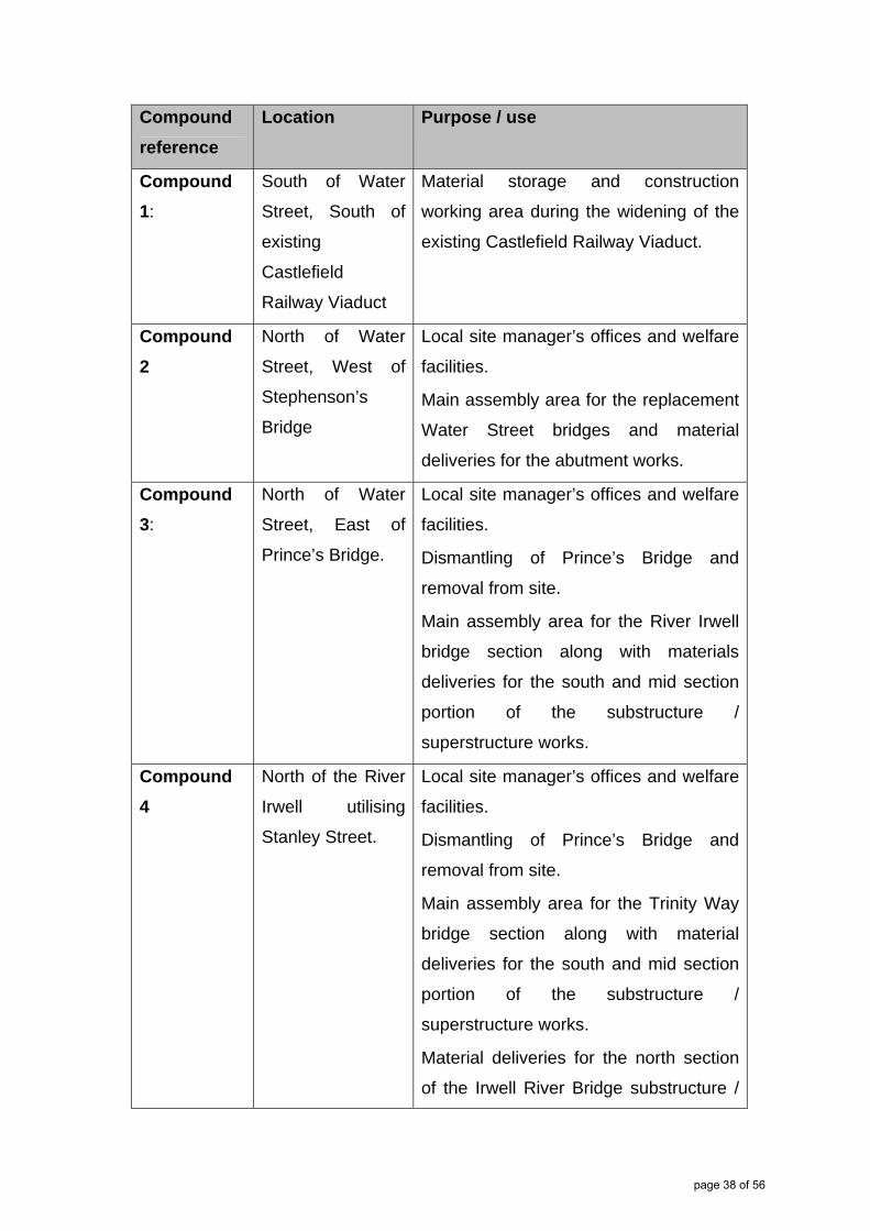
Compound
reference
Location Purpose / use
Compound
1:
South of Water
Street, South of
existing
Castlefield
Railway Viaduct
Material storage and construction
working area during the widening of the
existing Castlefield Railway Viaduct.
Compound
2
North of Water
Street, West of
Stephenson’s
Bridge
Local site manager’s offices and welfare
facilities.
Main assembly area for the replacement
Water Street bridges and material
deliveries for the abutment works.
Compound
3:
North of Water
Street, East of
Prince’s Bridge.
Local site manager’s offices and welfare
facilities.
Dismantling of Prince’s Bridge and
removal from site.
Main assembly area for the River Irwell
bridge section along with materials
deliveries for the south and mid section
portion of the substructure /
superstructure works.
Compound
4
North of the River
Irwell utilising
Stanley Street.
Local site manager’s offices and welfare
facilities.
Dismantling of Prince’s Bridge and
removal from site.
Main assembly area for the Trinity Way
bridge section along with material
deliveries for the south and mid section
portion of the substructure /
superstructure works.
Material deliveries for the north section
of the Irwell River Bridge substructure /
page 38 of 56
superstructure works.
Compound
5:
North of Trinity
Way and
Middlewood
viaduct
Main Project office and administrative
complex including welfare facilities, car
park for both staff and site operatives.
Secondary material storage for other site
compounds and secure small plant
storage
Access to Middlewood Viaduct widening
and strengthening works including new
installation of rail systems.
Access to and material deliveries for
Trinity Way bridge north section sub and
super structure works.
Compound
6
Existing Network
Rail maintenance
compound, south
of the existing
railway viaduct
with access from
Chapel Street
This area will be used primarily for
material storage and to provide an
access for personnel and plant to the
railway
Compound
7:
South of Salford
Central Station
with access from
New Bailey Street
Local site manager’s offices and welfare
facilities.
Material deliveries for works associated
with arch strengthening works.
Figure 11: Ordsall Chord Proposed Construction Compounds
8.1.4 Adequate room will be provided at entrances to these compounds to
ensure waiting vehicles do not result in queuing onto the highways.
8.1.5 A traffic management plan will also be developed, which identifies
measures to minimise the impact on the local highway network during
page 39 of 56
construction. Further information will be available during the next stage
of consultation in spring 2013.
8.2 Construction Deliveries
8.2.1 Materials required for the proposed bridge and viaduct structures will
be delivered by road to the compounds. The design will make sure,
wherever possible, components are fabricated to enable deliveries on
articulated lorries and subsequently assembled on site. However,
where this is not possible and would result in an abnormal load, these
would be delivered during the night to minimise the impact on local
peak traffic times. Any abnormal loads will be discussed with the
highways authority.
8.2.2 A number of strategic construction traffic routes have been identified
which access the site compounds from the west via the M602 (see
Appendix J). From the M602, it is proposed that the main construction
traffic will be directed via the A57 Regent Road and onto A6042 Trinity
Way. The strategic construction traffic routes are shown on drawing
‘Strategic Construction Traffic Routes and Haul Roads’ at Appendix H.
8.2.3 The potential impact of construction traffic on the highway is currently
being assessed as part of the ongoing Environmental Impact
Assessment. The assessment may introduce the need to provide
alternative or replacement construction traffic routes, which will be
included in the next stage of consultation.
8.2.4 Railway system components will be delivered to the point of installation
by rail wherever practicable; particularly those new rail systems which
run at the side of existing rail infrastructure.
page 40 of 56
8.2.5 Consideration has been given to delivery of construction materials by
river but for the following reasons this option is not considered feasible
because:
Construction and removal of a jetty will disturb the river bed
unnecessarily and the location could affect the construction of the
new section of river-spanning bridge.
The river draft is very shallow and it is unlikely that delivery barges
will get access to bank side jetties without extensive river bed
dredging.
The materials will need to be off loaded from lorries onto barges at
a remote canal basin. The Motorway and inner city ring road are
close by and there is little advantage gained by double handling
materials.
Increase likelihood of a dangerous river related event occurring
whilst operatives are handling river vessels and unloading materials
8.3 Construction Activities
8.3.1 All the compounds identified above would be required for the duration
of the construction programme and will be used simultaneously. The
main construction activities would be undertaken during daylight hours
only. However, there will be periods of construction located on or
adjacent to the existing railway viaducts that need to be undertaken at
night when trains are not running. The impact of potential construction
operations outside of daylight hours is currently being assessed as part
of the Environmental Impact Assessment.
8.3.2 Network Rail is considering the best way to plan and programme the
construction of the proposed new railway and is committed to building
considerately with minimum disruption to local residents and
businesses.
page 41 of 56
8.3.3 The compound sites, where possible, will be restored to their original
state upon completion of the project. There will be areas, however,
that are permanently impacted by the proposed scheme, particularly
along the alignment of the Ordsall Chord.
8.3.4 A plan showing the proposed construction compounds and vehicle
routes are provided on the ‘Temporary Affected Land’ drawing at
Appendix H.
8.4 Highway and Public Right of Way Diversions
8.4.1 Construction of the Ordsall Chord will necessitate partial or full road
and public right of way closures and traffic/pedestrian management
measures. A traffic assessment has been prepared which examines
the impacts on general traffic due to these proposed road closures and
identifies potential traffic management options:
Trinity Way (A6042): both structural form options include a
proposed two span viaduct across Trinity Way. Alterations to the
existing layout will be required while the piers in the central
reservation and the abutments on either side of the carriageways
are built. The design team is developing options that seek to retain
two lanes of traffic in either direction and minimise the impact on the
traffic movements in this location.
Water Street (B5225): it is proposed to construct a new single span
bridge across Water Street for the new Ordsall Chord. The main
construction works would be undertaken during an extended
blockade of the existing railway line and during this period, a
complete road closure of Water Street would be required. In
advance of this blockade, there would be a requirement to
undertake preparatory works on the existing abutments, either side
page 42 of 56

of Water Street, which would require temporary single lane closures
during construction.
Potato Wharf: The temporary road closure of Potato Wharf is
required in order to facilitate widening of the existing railway bridge
across Potato Wharf.
River Irwell Towpath: During construction, access to the towpath
along part of the north bank of the River Irwell and the footpath
along the east side of the Manchester, Bolton & Bury Canal will be
temporarily closed. Pedestrian diversions will be agreed with the
local authority and put in place whilst these routes are closed.
8.4.2 The development will result in the permanent closure of a private
access road from Water Street which extends along the north side of
Castlefield Viaduct linking Water Street with Woollam Place. The
permanent closure of this road will affect access to the Network Rail
arches but will not affect access for residents of Woollam Place as they
will be able to continue to access from Woollam Place off Liverpool
Road.
8.4.3 As outlined above, the development will also result in the permanent
closure and diversion of the public right of way across Prince’s Bridge.
8.4.4 Further details are provided at Appendix I.
8.5 Construction Programme
8.5.1 The main construction phase for Ordsall Chord is likely to be
undertaken between January 2015 and December 2016. The general
construction sequence will firstly involve setting up all site compounds
and undertaking site clearance and demolition works as required
(enabling works). Following this, the main construction sequence will
page 43 of 56

be to construct the new viaduct and bridge structures with works on
various sections of the Ordsall Chord at the same time.
8.5.2 The final stage will be to install the new railway infrastructure and the
commissioning phase. Multiple work fronts are envisaged through the
construction period in order to maximise the construction productivity
and ensure that the proposed project completion date of December
2016 is achieved.
8.6 Temporary Affected Land
8.6.1 During the construction of Ordsall Chord, temporary land will be
required for the purpose of providing site compounds and construction
working areas. Please refer to drawing entitled ‘Temporary Affected
Land’ at Appendix I for further information
8.7 Permanent Affected Land
8.7.1 Please refer to drawing entitled ‘Permanent Affected Land’ at Appendix
I. This land will be required to construct the new railway.
page 44 of 56

9.0 Programme and Next Steps
9.1 Phase 2 Consultation
9.1.1. Phase 2 consultation is taking place under section 42 (statutory
consultees, local authorities and landowners or anyone with an interest
in land which is potentially affected) and section 47 (public
consultation) of the Planning Act 2008.
9.2 Technical Consultation (Statutory Consultees)
9.2.1 The deadline for responses to this consultation pack is ?? December
2012. Who and where to send the feedback to is included in the
covering letter which was sent with this pack.
9.3 Public Consultation
9.3.1 In accordance with its Statement of Community Consultation, which is
available to view at the website below, Network Rail will seek to consult
with the local community and interested stakeholders through a multi-
stage consultation process. Consultation with people living in the
vicinity, and interested parties outside of the land proposed for the
infrastructure works is being done in three stages.
9.3.2 This phase of public consultation will take place from 20 November
2012 for a period of four weeks until 21 December 2012.
9.3.3 This consultation period includes a range of public events across
Manchester and Salford where those affected, members of the public
and statutory consultees can obtain more information about the
development proposals. Further information is also available at
http://www.networkrail.co.uk/north/Ordsall-Chord.aspx .
page 45 of 56

9.3.4 Any responses received will then be considered and will be used to
inform the ongoing design development and application document
preparation.
9.4 Phase 3 Consultation
9.4.1 The final stages of statutory and public consultation are planned for
spring 2013. This will include an information round and consultation on
the draft application documents.
9.4.2 The timescales for stage 3 of the consultation will be published on
Network Rail’s website in advance of any activity. Details will also be
made available in the press and through Network Rail’s promotional
activity relating to the scheme. Network Rail is committed to ongoing
consultation and engagement with interested parties after the
application has been submitted to the Planning Inspectorate. This will
continue through to determination of the proposal and beyond to
completion of the scheme.
9.5 Submission of the Development Consent Order application
9.5.1 Any issues raised during the third phase of consultation will be
considered and the draft application documents and drawings
amended where appropriate before the application is formally
submitted to the Planning Inspectorate in summer 2013.
9.5.2 Once the application has been accepted by the Planning Inspectorate,
they will hold an examination to consider all relevant issues before
making a formal recommendation.
9.5.3 Subject to receiving recommendation from the Planning Inspectorate
and an Order made by the Secretary of State, construction of the chord
is expected to commence in January 2015 with completion and
operation by December 2016.
page 46 of 56

Appendices
page 47 of 56

Appendix A: Location Plan
page 48 of 56

Appendix B: Initial Alignment Options
page 49 of 56

Appendix C: Preferred Alignment
page 50 of 56

Appendix D: Constraints Plan
page 51 of 56

Appendix E: Update on Preliminary Environmental Information
page 52 of 56

Appendix F: Replacement Pedestrian and Cycle Bridge Location
page 53 of 56

Appendix G: Options to Divert Utilities
page 54 of 56

Appendix H: Compound Locations and Strategic Construction Routes
page 55 of 56

Appendix I: Temporary and Permanent Land Plans
page 56 of 56


