Planning & Zoning Commission Workshop Meeting Agenda Mayfield Village Thurs July 18, 2019 7:30 p.m. MEMBERS Mr. Vetus Syracuse, Chairman Mr. Anthony Coyne Law Director Mr. Paul Fikaris, Chairman Pro Tem Mr. John Marquart Economic Development Manager Mr. Allen Meyers Mr. Tom Cappello Village Engineer Mr. Jim Farmer Mr. John Marrelli Building Commissioner Dr. Sue McGrath Ms. Deborah Garbo Commission Secretary Mr. Jim Kless Mr. Joseph Saponaro Council Alternate Mayor Bodnar PROPOSALS 1. Lot Split & Consolidation Mayfield City School District Center Elementary School 6625 Wilson Mills Rd. Then Design Architecture (tda) McSteen Land Surveyors 2. Preliminary Site Plan Planned Residential Development District PRDD - Highland Rd. 345 Miner Rd., LLC Skoda Construction Polaris Engineering Note: Meeting will be held at the Mayfield Village Civic Center, Main Conference Room at 6622 Wilson Mills Rd 44143. cc: Mayor, Director of Administration, Council, Clerk of Council, Economic Development Manager, Dept. Heads, Law Dept., Engineer, P & Z, A.R.B. & B.O.A.
Transcript
Planning & Zoning Commission
Workshop Meeting Agenda
Mayfield Village
Thurs
July 18, 2019
7:30 p.m.
MEMBERS
Mr. Vetus Syracuse, Chairman Mr. Anthony Coyne Law Director
Mr. Paul Fikaris, Chairman Pro Tem Mr. John Marquart Economic Development Manager
Mr. Allen Meyers Mr. Tom Cappello Village Engineer
Mr. Jim Farmer Mr. John Marrelli Building Commissioner
Dr. Sue McGrath Ms. Deborah Garbo Commission Secretary
Mr. Jim Kless Mr. Joseph Saponaro Council Alternate
Mayor Bodnar
PROPOSALS
1. Lot Split & Consolidation Mayfield City School District
Center Elementary School
6625 Wilson Mills Rd.
Then Design Architecture (tda)
McSteen Land Surveyors
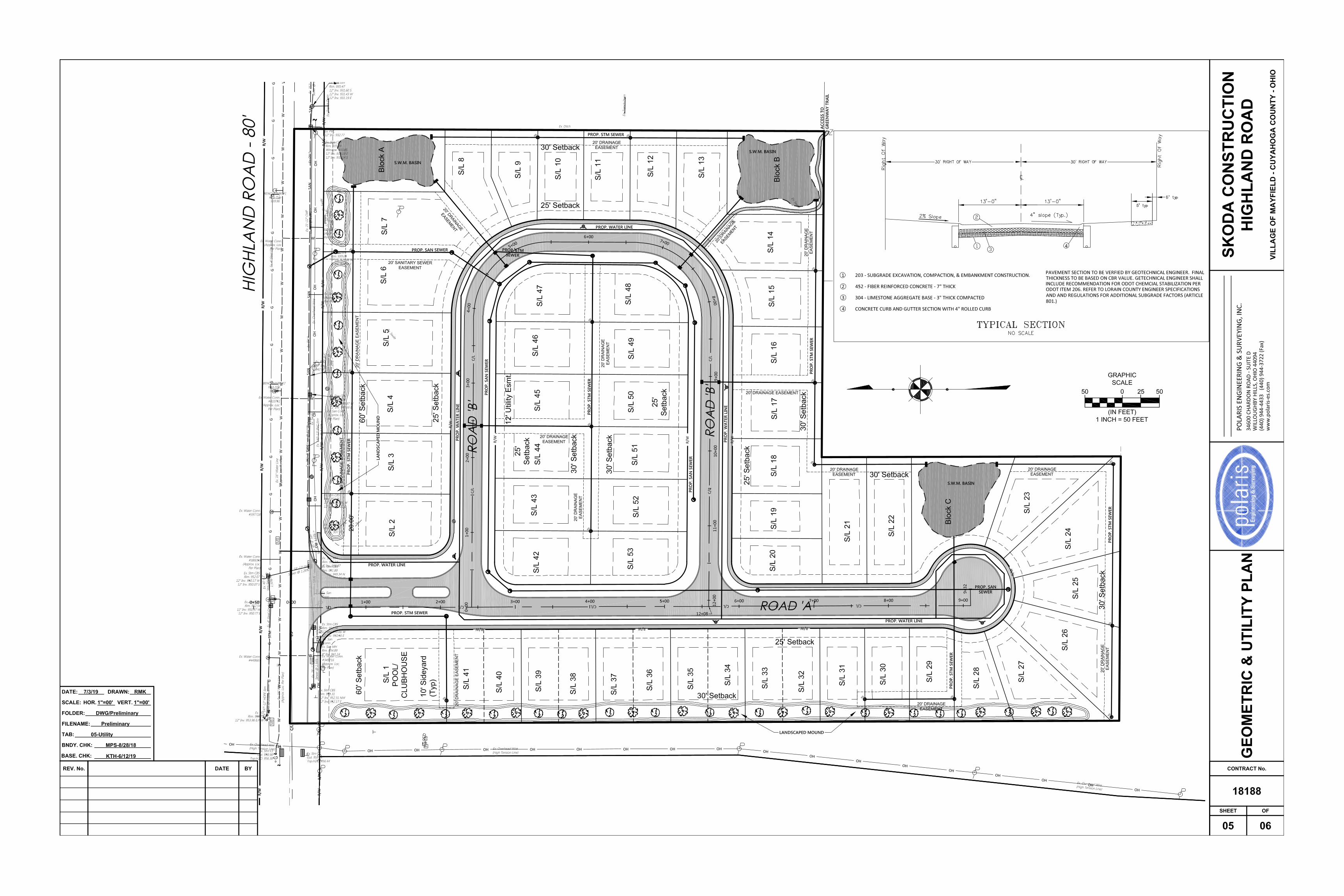
2. Preliminary Site Plan Planned Residential Development District
PRDD - Highland Rd.
345 Miner Rd., LLC
Skoda Construction
Polaris Engineering
Note: Meeting will be held at the Mayfield Village Civic Center, Main Conference Room at
6622 Wilson Mills Rd 44143.
cc: Mayor, Director of Administration, Council, Clerk of Council, Economic Development
Manager, Dept. Heads, Law Dept., Engineer, P & Z, A.R.B. & B.O.A.
LO
T S
PLIT
AN
D C
ON
SO
LID
ATIO
NFO
R G
ER
GIA
N M
ED
ICA
L A
RTS
, LLC
VO
LU
ME 3
29,
PA
GE 8
7 C
.C.M
.R.
1415 East 286th Street Wickliffe, OH 44092Phone: 440.585.9800 www.mcsteen.com
PROPOSED INGRESS EGRESS EASEMENT FOR MAYFIELD BOARD OF EDUCATION
AutoCAD SHX Text
BETA DRIVE (60')
AutoCAD SHX Text
1" REBAR IN MON. BOX. FD. & USED WILSON MILLS STA. 152+80.18
AutoCAD SHX Text
C
AutoCAD SHX Text
L
AutoCAD SHX Text
C
AutoCAD SHX Text
L
AutoCAD SHX Text
APPROVALS This plat is hereby approved by the Planning Commission of the Village of Mayfield, Ohio, this day of , 2019. day of , 2019. , 2019. Chairman of the Planning Commission Secretary of the Planning Commission This plat is hereby approved by the Village Engineer for the Village of Mayfield, Ohio, this day of , 2019. day of , 2019. , 2019. Village Engineer
AutoCAD SHX Text
ACCEPTANCE I, the undersigned Representative of the Mayfield Board of Education, owner of the land shown hereon, do hereby accept this Lot Split as shown hereon. Print NameSignature & Title Signature & Title TITLE COUNTY OF CUYAHOGA STATE OF OHIO Before me, a Notary Public in and for said County and State, personally appeared the above named Representative of the Mayfield Board of Education, who acknowledged the signing of the foregoing instrument, and that it was of their free act and deed personally. In witness whereof, I have hereunto set my hand and official seal at , , Ohio, this day of , 2019. day of , 2019. , 2019. Notary PublicMy Commission ExpiresMy Commission Expires
AutoCAD SHX Text
LOT SPLIT AND CONSOLIDATION for 6625 WILSON MILLS ROAD Known as being part of Original Mayfield Township Lot No. 45, Tract 1, part of Original Mayfield Township Lot No. 45, Tract 1, , now situated in the VILLAGE OF MAYFIELD COUNTY OF CUYAHOGA - STATE OF OHIO
AutoCAD SHX Text
Job No.: 19-001 Field Date: January 11, 2019 Survey Date: February 12, 2019 Drawn By: TEE Latest Revision Date: March 11, 2019 July 2, 2019
AutoCAD SHX Text
This survey is a boundary survey prepared in accordance with Chapter 4733-37, Ohio Administrative Code. The basis of bearings for this survey are from GNSS observations to the Ohio State Plane Coordinates System, North Zone, NAD83 (2011) datum derived through the O.D.O.T. V.R.S. Zone, NAD83 (2011) datum derived through the O.D.O.T. V.R.S. Network. Distances are given in feet and decimal parts thereof. All iron pins shown as set are 30" long 5/8" rebar with an identification cap stamped "McSTEEN CA 96-026".
AutoCAD SHX Text
WILLIAM E. TRUNICK JR. Professional Surveyor No. 8756
AutoCAD SHX Text
GRAPHIC SCALE
AutoCAD SHX Text
0
AutoCAD SHX Text
25
AutoCAD SHX Text
50
AutoCAD SHX Text
50
AutoCAD SHX Text
1 INCH = 50 FEET
AutoCAD SHX Text
I, the undersigned Representative of the Village of Mayfield, owner of the land shown hereon, do hereby accept this Lot Split as shown hereon. Print NameSignature & Title Signature & Title TITLE COUNTY OF CUYAHOGA STATE OF OHIO Before me, a Notary Public in and for said County and State, personally appeared the above named Representative of the Village of Mayfield, who acknowledged the signing of the foregoing instrument, and that it was of their free act and deed personally. In witness whereof, I have hereunto set my hand and official seal at , , Ohio, this day of , 2019. day of , 2019. , 2019. Notary PublicMy Commission ExpiresMy Commission Expires
AutoCAD SHX Text
CURVE
AutoCAD SHX Text
TANGENT
AutoCAD SHX Text
ARC LENGTH
AutoCAD SHX Text
DELTA
AutoCAD SHX Text
RADIUS
AutoCAD SHX Text
CHORD DISTANCE
AutoCAD SHX Text
CHORD BEARING
AutoCAD SHX Text
CURVE DATA
AutoCAD SHX Text
C1
AutoCAD SHX Text
31°30'28" CALC. & USED
AutoCAD SHX Text
120.84' CALC. & USEDCALC. & USED
AutoCAD SHX Text
66.45' CALC. & USED CALC. & USEDCALC. & USED
AutoCAD SHX Text
34.09' CALC. & USED CALC. & USEDCALC. & USED
AutoCAD SHX Text
65.62' CALC. & USED CALC. & USEDCALC. & USED
AutoCAD SHX Text
N 45°17'48" W
AutoCAD SHX Text
C2
AutoCAD SHX Text
78°43'22" CALC. & USED
AutoCAD SHX Text
85.89' CALC. & USEDCALC. & USED
AutoCAD SHX Text
118.02' CALC. & USED CALC. & USEDCALC. & USED
AutoCAD SHX Text
70.46' CALC. & USED CALC. & USEDCALC. & USED
AutoCAD SHX Text
108.95' CALC. & USED CALC. & USEDCALC. & USED
AutoCAD SHX Text
N 68°54'10" W
AutoCAD SHX Text
C3
AutoCAD SHX Text
89°40'28" CALC. & USED
AutoCAD SHX Text
191.77' CALC. & USEDCALC. & USED
AutoCAD SHX Text
300.14' CALC. & USED CALC. & USEDCALC. & USED
AutoCAD SHX Text
190.68' CALC. & USED CALC. & USEDCALC. & USED
AutoCAD SHX Text
270.43' CALC. & USED CALC. & USEDCALC. & USED
AutoCAD SHX Text
N 63°25'36" W
AutoCAD SHX Text
LINE
AutoCAD SHX Text
BEARING
AutoCAD SHX Text
DISTANCE
AutoCAD SHX Text
L1
AutoCAD SHX Text
S 89°31'02" W
AutoCAD SHX Text
50.00' REC. & USED REC. & USED
AutoCAD SHX Text
LINE DATA
AutoCAD SHX Text
L2
AutoCAD SHX Text
S 89°31'02" W
AutoCAD SHX Text
70.52' REC. & USED REC. & USED
AutoCAD SHX Text
L3
AutoCAD SHX Text
N 00°51'43" W
AutoCAD SHX Text
38.01' CALC. & USED CALC. & USED
AutoCAD SHX Text
L4
AutoCAD SHX Text
S 89°30'44" W
AutoCAD SHX Text
113.19' REC. & USED REC. & USED
AutoCAD SHX Text
L5
AutoCAD SHX Text
N 00°51'43" W
AutoCAD SHX Text
28.57' CALC. & USED CALC. & USED
AutoCAD SHX Text
L6
AutoCAD SHX Text
S 00°55'11" E
AutoCAD SHX Text
20.00' REC. & USED REC. & USED
AutoCAD SHX Text
L7
AutoCAD SHX Text
N 29°32'34" W
AutoCAD SHX Text
24.30' CALC. & USED CALC. & USED
AutoCAD SHX Text
L8
AutoCAD SHX Text
S 71°44'13" W
AutoCAD SHX Text
31.04' CALC. & USED CALC. & USED
AutoCAD SHX Text
L9
AutoCAD SHX Text
S 00°55'11" E
AutoCAD SHX Text
88.00' REC. & USED REC. & USED
AutoCAD SHX Text
L10
AutoCAD SHX Text
S 66°43'41" E
AutoCAD SHX Text
43.85' REC. & USED REC. & USED
AutoCAD SHX Text
L11
AutoCAD SHX Text
S 00°51'43" E
AutoCAD SHX Text
51.48' REC. & USED REC. & USED
AutoCAD SHX Text
L12
AutoCAD SHX Text
S 89°31'02" W
AutoCAD SHX Text
80.34' REC. & USED REC. & USED
AutoCAD SHX Text
L16
AutoCAD SHX Text
N 00°55'03" W
AutoCAD SHX Text
26.53' CALC. & USED 26.40' REC.
AutoCAD SHX Text
LINE
AutoCAD SHX Text
BEARING
AutoCAD SHX Text
DISTANCE
AutoCAD SHX Text
SURVEY REFERENCES - O.D.O.T. MR-1B 34(4) "Wilson Mills Road Improvement Plans", dated 1986. - O.D.O.T. CUY-91-13.29-S.O.M. CENTER ROAD, dated 2002. - "Lot Split and Consolidation for Georgian Medical Arts, LLC" recorded in Plat Vol. 329, Pg. 87 C.C.M.R., referred to as "PLAT".
AutoCAD SHX Text
LEGEND
AutoCAD SHX Text
denotes rebar found as noted denotes rebar inside monument box assembly found as noted denotes iron pipe found as noted denotes 5/8" diameter x 30" long rebar with "McSTEEN CA 96-026" ID cap set denotes empty monument box found as noted denotes P-K (masonry) nail set denotes brass disk in monument box assembly found as noted
AutoCAD SHX Text
ASPHALT PAVEMENT
AutoCAD SHX Text
CONCRETE PAVEMENT
AutoCAD SHX Text
CHAIN LINK FENCE
AutoCAD SHX Text
WOOD FENCE
AutoCAD SHX Text
METAL FENCE
AutoCAD SHX Text
CENTERLINE
AutoCAD SHX Text
RIGHT-OF-WAY
AutoCAD SHX Text
CALCULATED DISTANCE OR ANGLE
AutoCAD SHX Text
RECORD DISTANCE OR ANGLE
AutoCAD SHX Text
FOUND
AutoCAD SHX Text
FD.
AutoCAD SHX Text
REC.
AutoCAD SHX Text
CALC.
AutoCAD SHX Text
MONUMENT
AutoCAD SHX Text
MON.
AutoCAD SHX Text
R/W
AutoCAD SHX Text
C
AutoCAD SHX Text
L
AutoCAD SHX Text
CUYAHOGA COUNTY MAP RECORDSOUNTY MAP RECORDS
AutoCAD SHX Text
C.C.M.R..C.M.R.
AutoCAD SHX Text
CUYAHOGA COUNTY DEED RECORDS COUNTY DEED RECORDS
AutoCAD SHX Text
C.C.D.R..C.D.R.
AutoCAD SHX Text
O.D.O.T.
AutoCAD SHX Text
OHIO DEPARTMENT OF TRANSPORTATION
AutoCAD SHX Text
2
AutoCAD SHX Text
SHEET NO.
AutoCAD SHX Text
OF
AutoCAD SHX Text
1
AutoCAD SHX Text
INDEX OF SHEETS SHEET 1: OVERALL SITE BOUNDARY SURVEY OVERALL SITE BOUNDARY SURVEY SHEET 2:DETAIL OF OLD CENTER SCHOOLDETAIL OF OLD CENTER SCHOOL
AutoCAD SHX Text
Job No. 19-001 2019 McSteen & Associates, Inc.
AutoCAD SHX Text
L17
AutoCAD SHX Text
N 00°58'09" W
AutoCAD SHX Text
86.27' CALC. & USED
AutoCAD SHX Text
L13
AutoCAD SHX Text
N 89°39'58" E
AutoCAD SHX Text
30.00' REC. & USED
AutoCAD SHX Text
L14
AutoCAD SHX Text
S 00°55'11" E
AutoCAD SHX Text
20.00' REC. & USED
AutoCAD SHX Text
L15
AutoCAD SHX Text
S 89°39'58" W
AutoCAD SHX Text
30.00' REC. & USED
AutoCAD SHX Text
ACCESS EASEMENT MAYFIELD VILLAGE AFN 201211130877 C.C.D.R.
AutoCAD SHX Text
PROPOSED INGRESS EGRESS EASEMENT FOR MAYFIELD BOARD OF EDUCATION
VAULT WITH BACKFLOW PREVENTION AND METER PER CLEVELAND DIVISION OF WATER
AutoCAD SHX Text
PROPOSED INGRESS EGRESS EASEMENT FOR MAYFIELD BOARD OF EDUCATION
AutoCAD SHX Text
15" STORM
AutoCAD SHX Text
10" STORM
AutoCAD SHX Text
8" STORM
AutoCAD SHX Text
15" STORM
AutoCAD SHX Text
12" STORM
AutoCAD SHX Text
12" STORM
AutoCAD SHX Text
8" SANITARY
AutoCAD SHX Text
8" SANITARY
AutoCAD SHX Text
N 89°31'26" E 169.28' CALC. & USED169.28' CALC. & USEDCALC. & USED
AutoCAD SHX Text
188.00' CALC. & USED
AutoCAD SHX Text
ASPHALT PAVEMENT
AutoCAD SHX Text
S 89°31'26" W 150.00' CALC. & USED150.00' CALC. & USEDCALC. & USED
AutoCAD SHX Text
4" FIRE LINE
AutoCAD SHX Text
2" DOMESTIC LINE
AutoCAD SHX Text
16" WATER MAIN
AutoCAD SHX Text
EX. GAS
AutoCAD SHX Text
CONCRETE WALK
AutoCAD SHX Text
N 89°31'26" E 150.00' CALC. & USED150.00' CALC. & USEDCALC. & USED
AutoCAD SHX Text
G
AutoCAD SHX Text
G
AutoCAD SHX Text
ST
AutoCAD SHX Text
T
AutoCAD SHX Text
T
AutoCAD SHX Text
W
AutoCAD SHX Text
W
AutoCAD SHX Text
W
AutoCAD SHX Text
W
AutoCAD SHX Text
W
AutoCAD SHX Text
W
AutoCAD SHX Text
W
AutoCAD SHX Text
W
AutoCAD SHX Text
W
AutoCAD SHX Text
W
AutoCAD SHX Text
W
AutoCAD SHX Text
W
AutoCAD SHX Text
SN
AutoCAD SHX Text
ST
AutoCAD SHX Text
45.06' CALC. & USED ' CALC. & USED CALC. & USED S 00°55'11" E
AutoCAD SHX Text
Job No. 19-001 2019 McSteen & Associates, Inc.
AutoCAD SHX Text
DETAIL OF OLD CENTER SCHOOL AREA OF THE LOT SPLIT AND CONSOLIDATION for 6625 WILSON MILLS ROAD VILLAGE OF MAYFIELD COUNTY OF CUYAHOGA - STATE OF OHIO
AutoCAD SHX Text
GRAPHIC SCALE
AutoCAD SHX Text
0
AutoCAD SHX Text
10
AutoCAD SHX Text
20
AutoCAD SHX Text
20
AutoCAD SHX Text
1 INCH = 20 FEET
AutoCAD SHX Text
2
AutoCAD SHX Text
SHEET NO.
AutoCAD SHX Text
OF
AutoCAD SHX Text
2
AutoCAD SHX Text
INDEX OF SHEETS SHEET 1: OVERALL SITE BOUNDARY SURVEY OVERALL SITE BOUNDARY SURVEY SHEET 2:DETAIL OF OLD CENTER SCHOOL AREADETAIL OF OLD CENTER SCHOOL AREA
AutoCAD SHX Text
LEGEND
AutoCAD SHX Text
denotes 5/8" diameter x 30" long rebar with "McSTEEN CA 96-026" ID cap set denotes P-K (masonry) nail set denotes drill hole set
AutoCAD SHX Text
PROPOSED ACCESS AND PARKING EASEMENT
AutoCAD SHX Text
ASPHALT PAVEMENT
AutoCAD SHX Text
CONCRETE PAVEMENT
AutoCAD SHX Text
CENTERLINE
AutoCAD SHX Text
RIGHT-OF-WAY
AutoCAD SHX Text
CALCULATED DISTANCE OR ANGLE
AutoCAD SHX Text
RECORD DISTANCE OR ANGLE
AutoCAD SHX Text
FOUND
AutoCAD SHX Text
FD.
AutoCAD SHX Text
REC.
AutoCAD SHX Text
CALC.
AutoCAD SHX Text
R/W
AutoCAD SHX Text
C
AutoCAD SHX Text
L
AutoCAD SHX Text
CUYAHOGA COUNTY MAP RECORDS COUNTY MAP RECORDS
AutoCAD SHX Text
C.C.M.R.C.M.R.
AutoCAD SHX Text
CUYAHOGA COUNTY DEED RECORDS COUNTY DEED RECORDS
AutoCAD SHX Text
C.C.D.R..C.D.R.
AutoCAD SHX Text
O.D.O.T.
AutoCAD SHX Text
OHIO DEPARTMENT OF TRANSPORTATION
AutoCAD SHX Text
METAL FENCE
AutoCAD SHX Text
Source information from plans and markings has been combined with information from plans and markings has been combined with information from plans and markings has been combined with from plans and markings has been combined with from plans and markings has been combined with plans and markings has been combined with plans and markings has been combined with and markings has been combined with and markings has been combined with markings has been combined with markings has been combined with has been combined with has been combined with been combined with been combined with combined with combined with with with observed evidence of utilities to develop a view of those underground evidence of utilities to develop a view of those underground evidence of utilities to develop a view of those underground of utilities to develop a view of those underground of utilities to develop a view of those underground utilities to develop a view of those underground utilities to develop a view of those underground to develop a view of those underground to develop a view of those underground develop a view of those underground develop a view of those underground a view of those underground a view of those underground view of those underground view of those underground of those underground of those underground those underground those underground underground underground utilities. However, lacking excavation, the exact location of underground However, lacking excavation, the exact location of underground However, lacking excavation, the exact location of underground lacking excavation, the exact location of underground lacking excavation, the exact location of underground excavation, the exact location of underground excavation, the exact location of underground the exact location of underground the exact location of underground exact location of underground exact location of underground location of underground location of underground of underground of underground underground underground features cannot be accurately, completely and reliably depicted. Where cannot be accurately, completely and reliably depicted. Where cannot be accurately, completely and reliably depicted. Where be accurately, completely and reliably depicted. Where be accurately, completely and reliably depicted. Where accurately, completely and reliably depicted. Where accurately, completely and reliably depicted. Where completely and reliably depicted. Where completely and reliably depicted. Where and reliably depicted. Where and reliably depicted. Where reliably depicted. Where reliably depicted. Where depicted. Where depicted. Where Where Where additional or more detailed information is required, the client is advised that or more detailed information is required, the client is advised that or more detailed information is required, the client is advised that more detailed information is required, the client is advised that more detailed information is required, the client is advised that detailed information is required, the client is advised that detailed information is required, the client is advised that information is required, the client is advised that information is required, the client is advised that is required, the client is advised that is required, the client is advised that required, the client is advised that required, the client is advised that the client is advised that the client is advised that client is advised that client is advised that is advised that is advised that advised that advised that that that excavation may be necessary. (OUPS Reference Nos. B917701041-00B & may be necessary. (OUPS Reference Nos. B917701041-00B & may be necessary. (OUPS Reference Nos. B917701041-00B & be necessary. (OUPS Reference Nos. B917701041-00B & be necessary. (OUPS Reference Nos. B917701041-00B & necessary. (OUPS Reference Nos. B917701041-00B & necessary. (OUPS Reference Nos. B917701041-00B & (OUPS Reference Nos. B917701041-00B & (OUPS Reference Nos. B917701041-00B & Reference Nos. B917701041-00B & Reference Nos. B917701041-00B & Nos. B917701041-00B & Nos. B917701041-00B & B917701041-00B & B917701041-00B & & & B917701044-00B))
AutoCAD SHX Text
UTILITY NOTE
AutoCAD SHX Text
PROPOSED INGRESS EGRESS EASEMENT FOR MAYFIELD BOARD OF EDUCATION