PLANNING AND ZONING COMMISSION Regular Meeting Monday, August 28, 2017 Notice is hereby given that the Planning and Zoning Commission will hold a Regular Meeting at 7:00 p.m. on Monday, August 28, 2017, in the Council Chambers of Johnston City Hall, 6221 Merle Hay Road, Johnston, Iowa, to discuss the following business: AGENDA: 1. Call to Order 2. Roll Call 3. Approval of Agenda 4. Approval of Meeting Minutes: Regular Meeting of July 10, 2017 5. PZ Case No. 17- 01; Miller's Meadow Plat 1 Final Plat: The applicant, Stephen Miller, has obtained a special use permit from the Board of Adjustment to construct three, bi-attached dwelling units (duplex) on the subject property. The existing single-family home will remain. The plat subdivides the property into four lots. The property is located within an R-1(75) Single Family Residential Zoning District. Bi-attached dwellings are allowed in the R-1(75) Zoning District by issuance of a special use permit from the Board of Adjustment after review and recommendation from the Plan and Zoning Commission. 6. Other Business 7. Adjournment Next Scheduled Regular Meeting: Monday, September 11, 2017. Posted on or before August 25, 2017 at: Johnston City Hall, Johnston Public Library, Johnston Post Office, Johnston Public Works, Crown Point Community Center, and Johnston Website (http://www.cityofjohnston.com/agendacenter )
Transcript
PLANNING AND ZONING COMMISSION Regular Meeting Monday, August 28, 2017 Notice is hereby given that the Planning and Zoning Commission will hold a Regular Meeting at 7:00 p.m. on Monday, August 28, 2017, in the Council Chambers of Johnston City Hall, 6221 Merle Hay Road, Johnston, Iowa, to discuss the following business: AGENDA: 1. Call to Order 2. Roll Call 3. Approval of Agenda 4. Approval of Meeting Minutes: Regular Meeting of July 10, 2017 5. PZ Case No. 17- 01; Miller's Meadow Plat 1 Final Plat: The applicant, Stephen Miller, has
obtained a special use permit from the Board of Adjustment to construct three, bi-attached dwelling units (duplex) on the subject property. The existing single-family home will remain. The plat subdivides the property into four lots. The property is located within an R-1(75) Single Family Residential Zoning District. Bi-attached dwellings are allowed in the R-1(75) Zoning District by issuance of a special use permit from the Board of Adjustment after review and recommendation from the Plan and Zoning Commission.
6. Other Business 7. Adjournment Next Scheduled Regular Meeting: Monday, September 11, 2017. Posted on or before August 25, 2017 at: Johnston City Hall, Johnston Public Library, Johnston Post Office, Johnston Public Works, Crown Point Community Center, and Johnston Website (http://www.cityofjohnston.com/agendacenter)
PLANNING & ZONING COMMISSION City of Johnston 6221 Merle Hay Road, Johnston, IA 50131 Minutes Regular Meeting: Monday, July 10, 2017
AGENDA 1. Call to Order Substitute Chair Smith called the meeting to order at 7:00 p.m. 2. Roll Call Spencer Reddy Johnson Smith Pavlovec Petersma Anderson
Present X X X X Absent X X X
City Staff Present: David Wilwerding, Clayton Ender, Rebekah Davis
3. Election of Officers
Motion by Smith, seconded by Spencer to nominate Petersma as Chair and Johnson as Vice Chair. 4. Approval of Agenda Spencer Reddy Johnson Smith Pavlovec Petersma Anderson
Aye X X X X Nay Abstain
5. Approval of Meeting Minutes: Regular Meeting of June 12, 2017 Roll Call Vote: Spencer Reddy Johnson Smith Pavlovec Petersma Anderson
Aye X X X X Nay Abstain
6. PZ Case No. 17- 28; Site Plans for Traditions Children’s Center Building #2 at 9709 White Oak
Lane: The applicants, Bob and Bonnie Netteland have submitted site plans for a 6,880 square foot daycare facility expected to serve 125 clients. The property is immediately east of the existing Traditions Children’s Center constructed in 2012.
Wilwerding presented the staff report.
Page 2 of 6
Kevin Weggen, Civil Design Advantage, 3405 SE Crossroads Drive, Suite G, Grimes, Iowa, stated on behalf of the applicant that the proposed building is slightly smaller than the existing building (which serves 150 children). Weggen believes that the applicant plans on beginning construction at the beginning of August 2017 and ending construction before the school year begins in 2018. Motion by Spencer, seconded by Pavlovec to recommend approval of PZ Case No. 17- 28; Site Plans for Traditions Children’s Center Building #2 at 9709 White Oak Lane subject to conditions as outlined in the staff report. Roll Call Vote:
Spencer Reddy Johnson Smith Pavlovec Petersma Anderson
Aye X X X X Nay Abstain
7. PZ Case No. 17- 22; 6024 NW 59th Court Official Zoning Map Amendment: The applicant,
Thomas Leffler has requested a rezoning of approximately 0.54 acres and adjoining right-of-way from ROC-1, Mixed Use Center, to R-1(75), Single-Family Residential.
Ender presented the staff report. Smith inquired as to why the property had not been zoned for residential for a number of years. Ender explained that when the Mixed Use Center was originally envisioned for the area in 1998, the plan was that the subject property would be redeveloped. In 2007, a redevelopment study was conducted for the area that did not include the subject property as single family residential and the zoning district for the subject property remained Mixed Use Center. He added that the property has continued to be used as a single family home and the applicant is seeking to remove the nonconforming status. Smith opened for public hearing at 7:12 p.m. No public comment was received. Smith closed the public hearing at 7:13 p.m. Motion by Pavlovec, seconded by Spencer to recommend approval of PZ Case No. 17-22; amending the Official Zoning Map for .54 acres and adjoining right-of-way from ROC-1, Mixed Use Center, to R-1(75), Single-Family Residential District at 6024 NW 59th Court. Roll Call Vote:
Spencer Reddy Johnson Smith Pavlovec Petersma Anderson
Aye X X X X Nay Abstain
8. PZ Case No. 17- 27; Hidden Valley Estates Plat 2 Preliminary Plat: The applicant, Hidden Valley
Estates, LLC has submitted a preliminary plat for the subdivision of 16.14 acres into 25 buildable lots, 10 unbuildable out lots, and 1 street lot. The subject property is located south of Little Beaver Creek and immediately west of Hidden Valley Estates Plat 1 (west of NW 100th Street).
Ender presented the staff report. Smith inquired regarding the reasoning behind the cul-de-sac length restriction. Ender clarified that the length restriction is seeking to reduce the use on the road in the event that the residents get cut off from emergency vehicle access; the city would like to reduce the number of residents that could potentially
Page 3 of 6
be isolated. Ender added that the roadway in Hidden Valley Estates Plat 1 was engineered to protect against a 500-year flood event which exceeds the minimum requirement to protect against a 100-year flood event. This roadway was engineered to protect against a breach in the Benton Dam and/or flooding from Beaver Creek. The applicant has worked to ensure access in the event of an emergency. Jeff Strawhacker, 10351 NW 82nd Avenue, Grimes, Iowa, believes that the stream buffer is being encroached upon by the lots in the proposed development. He noted that the minimum lot frontage for the zoning district is 75’ however; Lots 11, 12, 13 & 14 have lot frontages less than 75’. He believes that the base flood elevation of 861 feet has not been met in the proposed development and that there is a discrepancy on the elevations proposed for the plat. He is concerned with the buffer area plan. He is concerned with the tree removal within the stream buffer requirement and believes that the size of the trees should prevent them from being removed. He is requesting that the trees in Area 2 remain. He is concerned with the safety and additional traffic from the number of houses on the cul-de-sac. He requested that there not be any street lighting in the proposed development. He believes that there should be a buffer between the residential land use and the forest reserve land use. He does not believe that the survey (as he has seen marked) was done was accurately. He requested specification on the restricted activities within the stream buffer and inquired how grading could be completed within the stream buffer. He has filed complaints with the police department regarding construction noise after working hours. Petersma arrived at 7:26 p.m. Judy Anderson, 5985 NW 61st Avenue, Johnston, Iowa, inquired if there were hours that construction can be completed. Strawhacker stated that the permitted hours of construction are from 6:30 a.m. to 9 p.m. Linda Evans, 7820 NW 100th Street, Grimes, Iowa, she noted that she lives adjacent to the Crosshaven development and stated that the noise from the construction equipment is throughout the day and evening without time restrictions. She is opposed to removing many trees in the area and believes that the trees are a beautiful feature for the area. She is opposed to the street lighting for the development and believes that the glare will be undesirable. She believes that the area should not have street lighting. She is concerned with the additional traffic from this development on NW 100th Street. Ender responded that “not developable” means no structures are permitted to be built within the area. Lots are permitted to extend into the stream buffer however; the stream buffer restricts structures being built in the easement. Base flood elevation of 858 and the 100-year flood elevation were both established by FEMA. The floodway fringe overlay zoning district requires 1 foot above the 100-year flood elevation. Wilwerding added that the base flood elevation is higher to the east and lowers as you continue west along the creek. Ender clarified that the stream buffer easement management plan has not been drafted yet but will be established at the final plat phase. Ender stated that the landscaping buffer has not been drafted yet. The fire department has reviewed the length of the cul-de-sac and believes that there will be adequate emergency vehicle access to the cul-de-sac. The developer has seeks to established a lot tie agreements with the buildable lots and the adjacent outlots. By means of the lot tie agreement, the homeowner will not be required to buy flood insurance. Street lighting is a city subdivision requirement and the street lighting plan for the proposed development has not been drafted yet. Petersma inquired if there was process to waive the street lighting requirement. Wilwerding stated there is no process to waive the street lighting requirement however; it can be proposed to City Council. Ender continued that there is no buffer requirement between single family and forest reserve. Ender reiterated the permitted construction hours. Ender added that the property boundary disagreement is a civil dispute.
Page 4 of 6
Strawhacker noted that there are trees set on the property boundary. He is concerned that the root system of the mature trees will be destroyed with grading activities. Mike Gentile, the applicant, noted that they ran their equipment twice. He noted that he lives on a cul-de-sac of 33 houses with minimal traffic. David Bentz, Bishop Engineering, 3501 104th St, Urbandale, Iowa, clarified that he is not requesting that there not be street lighting. He noted that the slopes are 1-1 and 2-1 and the road will need to be built up out of the flood plain. In building the pad for the properties to the north (specifically Lot 11) the grading may come close (5-10 feet) from the property boundary. This distance should not disturb the root system of the trees on adjacent property. He added that the city is requesting stream bank stabilization. He explained that dirt will be brought in from the hillside to build up the road. Regarding the survey, he noted that the northern corner (property pins) have been established and recorded in the same location in a few other surveys. To his knowledge, he doesn’t believe that additional land was deeded to Strawhacker. Strawhacker believes that the property line as established by the survey Bishop Engineering performed taper onto his property. Smith inquired regarding the tree removal and protected tree status. Ender explained, for the applicant to remove trees they have to be identified on a tree removal plan on the preliminary plat. The intent is to protect as many trees as possible. Ender believes that the applicant is attempting to limit the grading and save as many trees as possible. Spencer inquired as to how many trees are in Area 2. Ender stated that there are 58 trees. Pavlovec believes that the majority of the trees are ash trees and it could be argued that they may have to be removed in the future. Mike Gentile, the applicant, noted that they do not want to remove more trees than necessary however, they would prefer to identify that all the trees will be removed and save what they can rather than have to remove more trees than initially planned. Pavlovec is not in support of a long cul-de-sac and without street lighting. Spencer would like to be consistent with the requirements for the city and believes that the subdivision should have street lighting. Petersma inquired if the height of the street light could be lower. Wilwerding noted that there can be variations in height and fixture types. He believes that MidAmerican Energy is only providing LED lights which tend to be brighter. Light level is the city requirement not a specific fixture or fixture height. Petersma inquired if there is a condition that could be added to reduce the brightness of the lighting. Wilwerding explained that there is a requirement for minimum lighting. Motion by Petersma seconded by Pavlovec to recommend approval of PZ Case No. 17-27; Hidden Valley Estates Plat 2 Preliminary Plat the Preliminary Plat for Hidden Valley Estates Plat 2 subject to the conditions as outlined in the staff report. Roll Call Vote:
Spencer Reddy Johnson Smith Pavlovec Petersma Anderson
Aye X X X X X Nay Abstain
Page 5 of 6
Commission Spencer departed at 8:07 p.m. The position of Chair was bestowed upon Petersma at 8:08 p.m. 9. PZ Case No. 17- 29; Crosshaven Outlots Plat 3 Final Plat: The applicant, Hubbell Realty
Company and Crosshaven I LLC have submitted a final plat for the subdivision of 93.52 acres into 1 street lot to be dedicated to the City and 8 unbuildable outlots. The intent of this plat is to facilitate the transfer of property.
Ender presented the staff report. Motion by Smith, seconded by Pavlovec to recommend approval of PZ Case No. 17- 29; Crosshaven Outlots Plat 3 Final Plat subject to the conditions as outlined in the staff report. Roll Call Vote:
Spencer Reddy Johnson Smith Pavlovec Petersma Anderson
Aye X X X X X Nay Abstain
10. PZ Case No. 17- 30; Crosshaven Plat 8 Final Plat: The applicant, Hubbell Realty Company has
submitted a Final Plat for the subdivision of 1.90 acres into 1 street lot to be dedicated to the City, 1 unbuildable outlot, and 4 buildable lots.
Ender presented the staff report. Smith noted the Foth comment letter dated July 7, 2017 which discussed how the 100-year floodplain limits were calculated without the improvements. She inquired as to when this comment will be addressed. Ender stated that the plat cannot be recorded until the issue has been resolved and clarified that the FEMA floodplain line shifted due to the grading that had occurred. Smith inquired if the floodplain line would be outside of the lot. Brad Brockman, McClure Engineering, 1360 NW 121st St, Clive, Iowa, explained that the lots have been raised outside of the floodplain and the floodplain line would shift to the south. Motion by Smith seconded by Pavlovec to recommend approval of PZ Case No. 17- 30; Crosshaven Plat 8 Final Plat subject to the conditions as outlined in the staff report. Roll Call Vote:
Spencer Reddy Johnson Smith Pavlovec Petersma Anderson
Aye X X X X X Nay Abstain
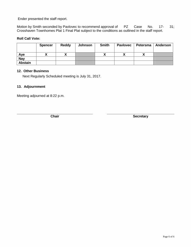
11. PZ Case No. 17- 31; Crosshaven Townhomes Plat 1 Final Plat: The applicant, Hubbell Realty
Company has submitted a final plat for the subdivision of 9.53 acres into 41 townhome lots and 1 private street lot. The subject property is located east of NW 100th Street and north of the future eastward extension of NW 82nd Avenue.
Page 6 of 6
Ender presented the staff report. Motion by Smith seconded by Pavlovec to recommend approval of PZ Case No. 17- 31; Crosshaven Townhomes Plat 1 Final Plat subject to the conditions as outlined in the staff report. Roll Call Vote:
Spencer Reddy Johnson Smith Pavlovec Petersma Anderson
Aye X X X X X Nay Abstain
12. Other Business
Next Regularly Scheduled meeting is July 31, 2017.
13. Adjournment Meeting adjourned at 8:22 p.m.
Chair Secretary
H:\Community Development\P&Z\2017 PZ\PZ 17-01; Miller's Meadow Plat 1 Minor Subdivision (MPL-17-0001) Page 1 of 5
ITEM NO. ______
Planning & Zoning Commission
COMMUNITY DEVELOPMENT DEPARTMENT
August 28th, 2017
Subject: Consider recommending approval of the final plat for Miller’s Meadow subdividing 1.58 acres into seven lots for property located at the northeast corner of NW 57th Avenue and NW 54th Court.
SYNOPSIS: The applicant has obtained a special use permit from the Board of Adjustment to construct three, bi-attached dwelling units (duplex) on the subject property. The existing single-family home will remain. The plat subdivides the property into four lots. The property is located within an R-1(75) Single Family Residential Zoning District. Bi-attached dwellings are allowed in the R-1(75) Zoning District by issuance of a special use permit from the Board of Adjustment after review and recommendation from the Plan and Zoning Commission.
RECOMMENDATION:
Staff recommends approval and provides the following motion for the commission’s consideration: The Planning & Zoning Commission recommends approval of PZ Case No. 17-01, the Final Plat for Miller’s Meadow, subject to the following conditions:
1. The project shall conform to the requirements, standards and regulations of the City of Johnston.
2. All final plat documentation shall be fully executed and delivered to City Staff (originals) for review and approval at least six (6) working days prior to the City Council meeting at which the final plat will be considered for approval.
3. City Council deferral of sidewalk installation along NW 54th Court and NW 57th Avenue until reconstruction of each road surface respectively, at which time it shall be installed with the road improvement project, or until otherwise directed by the city council, at which time the costs of such shall be assessed to the adjacent property owners.
4. Applicant submittal of an executed petition and waiver for improvements to NW 54th Court and NW 57th Avenue prior to the City Council approval of a final plat.
5. Applicant submittal of a stormwater management maintenance
H:\Community Development\P&Z\2017 PZ\PZ 17-01; Miller's Meadow Plat 1 Minor Subdivision (MPL-17-0001) Page 2 of 5
agreement to account for the long-term maintenance responsibilities and procedures of the basin.
6. Applicant shall provide a recorded maintenance agreement for that portion of the private drive within the access easement shown on Lot 1.
7. An engineer’s certification shall be provided certifying the elevation of all overland flowage and drainage way elevations that are on or immediately adjacent to the lot under construction and the plat shall indicate minimum protection elevations for any lot adjacent to a drainageway. Furthermore, the plat shall include a note stating all structures located on lots that have minimum protection elevations identified shall certify that the structure meets that elevation prior to the issuance of a certificate of occupancy for that structure.
8. The following amendments to the final plat shall be submitted Prior to City Council approval of the final plat:
a. Revisions sufficient to address review comments provided in a letter dated August 14, 2017 from Foth Infrastructure and Environment.
H:\Community Development\P&Z\2017 PZ\PZ 17-01; Miller's Meadow Plat 1 Minor Subdivision (MPL-17-0001) Page 3 of 5
REPRESENTATIVE: Ed Arp
Civil Engineering Consultants, Inc. 2400 86th Street, Unit 12 Des Moines, IA 50322
APPLICANT: Stephen Miller 3227 NW 11th Street Urbandale, IA 50322
BACKGROUND & PRIOR APPROVALS:
The subject properties were originally part of Lot 14, Fruitland subdivision recorded July 19th, 1909. Lot 14 was later subdivided into lots 1-5 of Hams Place, filed with the Polk County Recorder on November 9th, 1966 (Lots 4 and 5 being the subject properties). The home standing on Lot 5 today was constructed in 1914. The City of Johnston Board of Adjustment approved a special use permit to construct three bi-attached housing units (six units total) on the subject property on May 18, 2017. The Johnston City Council approved the preliminary plat and site plan depicting subdivision of the subject property into 4 lots housing seven housing units (original house plus six units of bi-attached housing) on June 19, 2017 via resolution 17-198.
ZONING & BULK REQUIREMENTS:
The R-1(75) zoning district requires the following bulk requirements for two family dwellings: Lot Area: 16,000 square feet Lot Width: 100 feet Front Yard Setback: 35 feet Side Yard Setbacks: 10 feet one side, sum of 20 feet Rear Yard Setback: 35 feet Lots 2 and 3 have frontage on NW 54th Court. Lot 1 (existing house) will maintain the current access to NW 57th Avenue. Lot 4 will have access to NW 57th Avenue via easement across Lot 1. Staff recommends a condition of approval requiring a maintenance agreement for that portion of the drive within said easement.
COMPREHENSIVE PLAN:
The subject property is depicted as “Low Density Residential” on the Johnston 2030 Future Land Use Map. Low Density is defined as two to five units per acre. The proposed plat lends a density of 4.43 units per acre and complies with the comprehensive plan.
TRAFFIC ACCESS & CIRCULATION:
NW57th Avenue is currently under reconstruction. Improvements to NW54th Court are tentatively scheduled to begin in the fall of 2017 with utility
H:\Community Development\P&Z\2017 PZ\PZ 17-01; Miller's Meadow Plat 1 Minor Subdivision (MPL-17-0001) Page 4 of 5
relocates and final project design. Construction of NW 54th Court is scheduled to begin April 2018.
PEDISTRIAN CIRCULATION & SIDEWALKS:
Pending reconstruction of both streets fronting the subject property, staff recommends City Council deferral of sidewalk installation along NW 54th Court and NW 57th Avenue until reconstruction of each road surface respectively, at which time it shall be installed with the road improvement project, or until otherwise directed by the city council, at which time the costs of such shall be assessed to the adjacent property owners.
PUBLIC UTILITIES:
The road improvements will include installation of sanitary sewer and water mains. The existing house is served by septic. While not required to connect to sanitary sewer, the septic will be abandoned and the home will connect to sanitary sewer at NW 57th Avenue. Lot 4 will also connect at NW 57th Avenue, while utility connections to Lots 2 and 3 are shown from NW 54th Court. an occupancy permit will not be issued for any structure prior to utility connections.
STORMWATER: The site is designed with a detention basin to store and treat stormwater from lots 1-4. Staff recommends a condition of approval mandating the basin be placed within an easement and the applicant to provide a stormwater management maintenance agreement to account for the long-term maintenance responsibilities and procedures of the basin.
In addition, an engineer’s certification shall be provided certifying the elevation of all overland flowage and drainage way elevations that are on or immediately adjacent to the lot under construction and the plat shall indicate minimum protection elevations for any lot adjacent to a drainageway. Furthermore, the plat shall include a note stating all structures located on lots that have minimum protection elevations identified shall certify that the structure meets that elevation prior to the issuance of a certificate of occupancy for that structure.
FLOODPLAIN:
The site is not located within the 100-year floodplain.
CONSULTANT COMMENTS:
Foth Infrastructure & Environment, LLC has reviewed the Site Plan and offered comments in their letter dated 8/14/17. Staff has incorporated any outstanding deficiencies be addressed as conditions of approval.
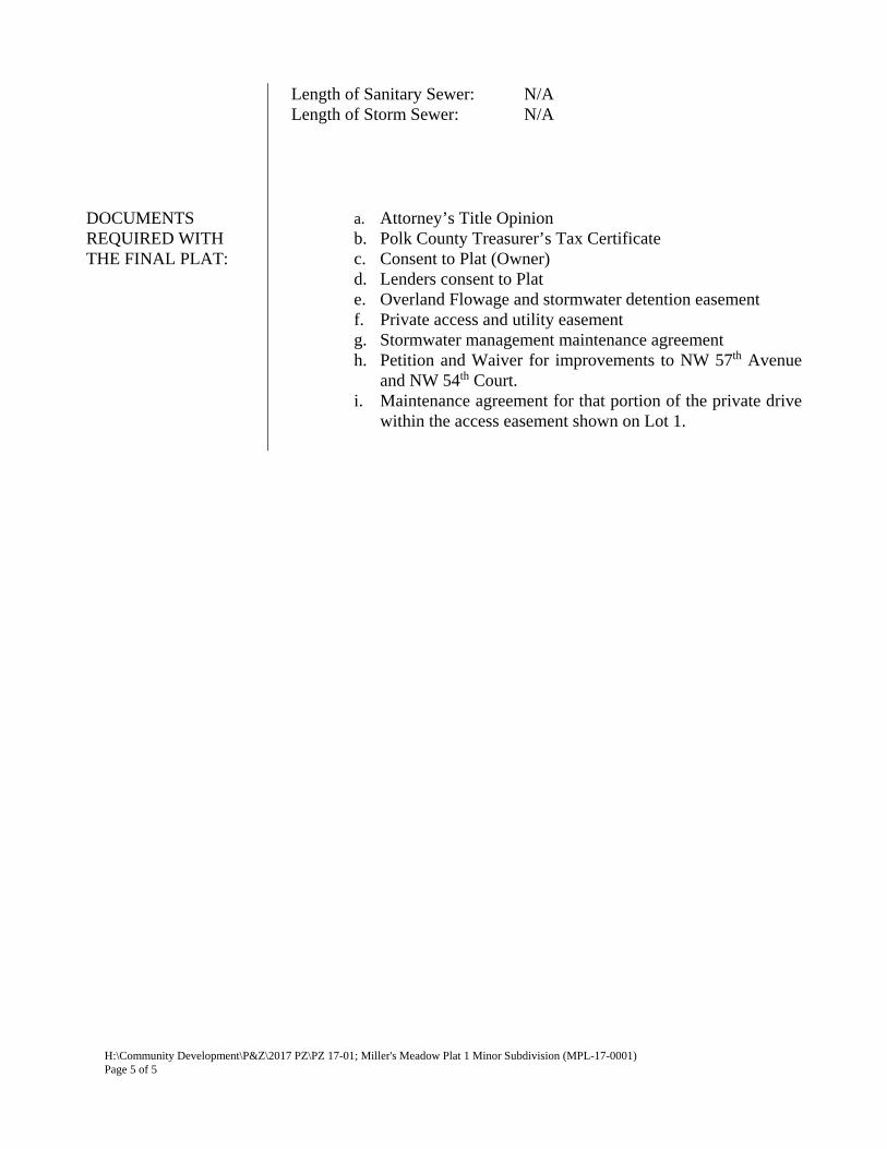
PLAT SUMMARY: Lots: 4 Area: 1.58 Acres Area of Streets: N/A Other Area Dedicated: N/A Outlot Area: N/A Net Area in Lots 1.58 Acres Net Average Lot Area: NA Length of Street: N/A Length of Water Main: N/A
H:\Community Development\P&Z\2017 PZ\PZ 17-01; Miller's Meadow Plat 1 Minor Subdivision (MPL-17-0001) Page 5 of 5
Length of Sanitary Sewer: N/A Length of Storm Sewer: N/A
DOCUMENTS REQUIRED WITH THE FINAL PLAT:
a. Attorney’s Title Opinion b. Polk County Treasurer’s Tax Certificate c. Consent to Plat (Owner) d. Lenders consent to Plat e. Overland Flowage and stormwater detention easement f. Private access and utility easement g. Stormwater management maintenance agreement h. Petition and Waiver for improvements to NW 57th Avenue
and NW 54th Court. i. Maintenance agreement for that portion of the private drive
within the access easement shown on Lot 1.
-Created by City of Johnston Department of Community Development
8191 Birchwood Court, Suite L Johnston, IA 50131 (515) 254-1393 Fax: (515) 254-1642
August 14, 2017
Aaron Wolfe, Senior Planner
City of Johnston, P.O. Box 410
6221 Merle Hay Road
Johnston, IA 50131
RE: Miller’s Meadow Plat 1
Development Review 3
Case No. PZ 17-01
Foth Infrastructure and Environment, LLC has completed a review of the Final Plat received by the City
August 3, 2017 for the above referenced project. Based on our review, the following comments are
offered:
1. Label addresses once provided by City staff.
2. Right of Way along NW 57th Avenue and NW 54th Court is 60’. This plat was part of the City’s NW
57th Avenue Improvement project and the NW 54th Court Improvement project.
3. Applicant shall provide a separate sheet that labels the critical grading elevations at property lines,
delineates and labels the proposed 100-yr elevation of Stormwater management basin, and lists
MPE’s for each lot; sheet shall be certified by a professional engineer licensed in the State of Iowa.
4. Several comments are still outstanding from the preliminary Plat Review dated April 12, 2017;
applicant shall submit an updated SWMP and Preliminary Plat.
Please contact me at 515.251.2564 if you have questions or comments.
Sincerely,
Foth Infrastructure & Environment, LLC
Joshua C. DeBower, P.E.
Lead Civil Engineer
mms3
·· ·
·
·
·
CEC
Civ
il En
gine
erin
g C
onsu
ltant
s, In
c.24
00 8
6th
Stre
et .
Uni
t 12
. D
es M
oine
s, Io
wa
503
2251
5.27
6.48
84 .
Fax
: 515
.276
.708
4 .
mai
l@ce
clac
.com
q:\A
-FIL
ES\A
-180
0\A
1806
\_c3
d dr
awin
gs\P
lat\A
1806
FIN
AL
PLA
T C
OV
ER.d
wg,
6/2
1/20
17 9
:30:
00 A
M, j
agad
dis,
1:1
AutoCAD SHX Text
RECORDER'S STAMP
AutoCAD SHX Text
APPLICANT / PREPARED FOR: STEPHEN D MILLER 3227 NW 111TH ST URBANDALE, IA 50322 & MB LLC 1125 28TH STREET WEST DES MOINES, IA 50265 PROPERTY OWNER: STEPHEN D MILLER 3227 NW 111TH ST URBANDALE, IA 50322 PROPERTY ADDRESS: 5385 NW 57TH AVENUE JOHNSTON, IOWA 50131 PROFESSIONAL LAND SURVEYOR: CIVIL ENGINEERING CONSULTANTS ATTN: JEFFREY A. GADDIS, PLS 2400 86TH STREET, SUITE 12 URBANDALE, IA 50322 PHONE: 515-276-4884 FAX: 515-276-7084 EMAIL: [email protected]
AutoCAD SHX Text
LEGAL DESCRIPTION: WARRANTY DEED (BOOK 16170, PAGE 142) LOTS 4 AND 5 IN HAM'S PLACE, AN OFFICIAL PLAT, NOW INCLUDED IN AND FORMING A PART OF THE CITY OF JOHNSTON, POLK COUNTY, IOWA.
AutoCAD SHX Text
CERTIFICATION
AutoCAD SHX Text
PLAT BOUNDARY
AutoCAD SHX Text
SET PROPERTY CORNER (5/8" I.R. W/BLUE CAP #18381 UNLESS OTHERWISE NOTED)
AutoCAD SHX Text
CENTERLINE STREET RIGHT-OF-WAY
AutoCAD SHX Text
PREVIOUSLY RECORDED BEARING & DISTANCE
AutoCAD SHX Text
P.
AutoCAD SHX Text
MEASURED BEARING & DISTANCE
AutoCAD SHX Text
M.
AutoCAD SHX Text
DEEDED BEARING & DISTANCE
AutoCAD SHX Text
D.
AutoCAD SHX Text
LEGEND
AutoCAD SHX Text
I.R.
AutoCAD SHX Text
IRON ROD
AutoCAD SHX Text
I.P.
AutoCAD SHX Text
IRON PIPE
AutoCAD SHX Text
COUNTY RECORDER'S INDEXING BOOK
AutoCAD SHX Text
BK. XXX, PG. XXX
AutoCAD SHX Text
RIGHT-OF-WAY
AutoCAD SHX Text
R.O.W.
AutoCAD SHX Text
FOUND SECTION CORNER
AutoCAD SHX Text
EXISTING PROPERTY LINES
AutoCAD SHX Text
EASEMENT LINES
AutoCAD SHX Text
PUBLIC UTILITY EASEMENT
AutoCAD SHX Text
P.U.E.
AutoCAD SHX Text
RETURN TO: CIVIL ENGINEERING CONSULTANTS ATTN: JEFFREY A. GADDIS, PLS 2400 86TH STREET, SUITE 12 URBANDALE, IA 50322 PHONE: 515-276-4884 EMAIL: [email protected]
AutoCAD SHX Text
NORTH
AutoCAD SHX Text
0' 500' 1000'
AutoCAD SHX Text
SCALE: 1"=500'
AutoCAD SHX Text
FINAL PLAT OF MILLERS MEADOW PLAT 1 ILLERS MEADOW PLAT 1 LLERS MEADOW PLAT 1 LERS MEADOW PLAT 1 ERS MEADOW PLAT 1 RS MEADOW PLAT 1 S MEADOW PLAT 1 MEADOW PLAT 1 MEADOW PLAT 1 EADOW PLAT 1 ADOW PLAT 1 DOW PLAT 1 OW PLAT 1 W PLAT 1 PLAT 1 PLAT 1 LAT 1 AT 1 T 1 1 1 5385 NW 57TH AVENUE, JOHNSTON, IOWA 50131 , JOHNSTON, IOWA 50131 JOHNSTON, IOWA 50131
AutoCAD SHX Text
FLOOD ZONE DESIGNATION THE DESCRIBED PROPERTY IS LOCATED WITHIN AN AREA HAVING A ZONE DESIGNATION 'X' BY THE FEDERAL EMERGENCY MANAGEMENT AGENCY (FEMA), ON FLOOD INSURANCE RATE MAP COMMUNITY PANEL NO. 1907450006D REVISED ON JULY 19, 2000. *** FLOOD INSURANCE RATE MAPS ARE SUBJECT TO CHANGE *** (SEE FEMA FLOOD MAP SERVICE CENTER FOR EFFECTIVE MAPS)
AutoCAD SHX Text
DRAWING INDEX
AutoCAD SHX Text
PAGE #
AutoCAD SHX Text
SHEET TITLE
AutoCAD SHX Text
1
AutoCAD SHX Text
COVER
AutoCAD SHX Text
2
AutoCAD SHX Text
FINAL PLAT
AutoCAD SHX Text
PROPOSED LOT LINES
AutoCAD SHX Text
FOUND CORNERS
AutoCAD SHX Text
CITY OF JOHNSTON PLANNING NOTES 1. THIS PLAT IS FOR THE TRANSFER OF LAND AND NO MAJOR DEVELOPMENT OR CHANGE OF USE THIS PLAT IS FOR THE TRANSFER OF LAND AND NO MAJOR DEVELOPMENT OR CHANGE OF USE SHALL OCCUR WITHOUT AN APPROVED SITE PLAN MEETING THE CITY OF JOHNSTON SITE PLAN REQUIREMENTS.
AutoCAD SHX Text
UTILITIES POTABLE WATER SUPPLY: CITY OF JOHNSTON SANITARY SEWER: CITY OF JOHNSTON
AutoCAD SHX Text
PURPOSE OF SURVEY THIS IS A MINOR SUBDIVISION PLAT FOR THE PURPOSE OF CREATING FOUR RESIDENTIAL LOTS.
AutoCAD SHX Text
ZONING DISTRICT R1-75' (WITH SPECIAL USE PERMIT) ZONING BULK REGULATIONS MINIMUM LOT AREA - 16,000 SF MINIMUM LOT WIDTH - 100' SETBACKS FRONT 35' SIDE/SUM: 10' / 20' TOTAL REAR: 35' MAXIMUM BUILDING HEIGHT: 35' MAXIMUM DEVELOPABLE UNITS PER ACRE: 5.4
AutoCAD SHX Text
DATE
AutoCAD SHX Text
JEFFREY A. GADDIS, IOWA LICENSE NO. 18381
AutoCAD SHX Text
PAGES OR SHEETS COVERED BY THIS SEAL:
AutoCAD SHX Text
MY LICENSE RENEWAL DATE IS DECEMBER 31, 2018
AutoCAD SHX Text
I HEREBY CERTIFY THAT THIS LAND SURVEYING DOCUMENT WAS PREPARED AND THE RELATED SURVEY WORK WAS PERFORMED BY ME OR UNDER MY DIRECT PERSONAL SUPERVISION AND THAT I AM A DULY LICENSED PROFESSIONAL LAND SURVEYOR UNDER THE LAWS OF THE STATE OF IOWA.
AutoCAD SHX Text
GADDIS
AutoCAD SHX Text
JEFFREY A.
AutoCAD SHX Text
I
AutoCAD SHX Text
O
AutoCAD SHX Text
W
AutoCAD SHX Text
A
AutoCAD SHX Text
18381
AutoCAD SHX Text
SHEETS 1 - 2
AutoCAD SHX Text
June 21, 2017
AutoCAD SHX Text
LAND SURVEYOR NOTES: 1. THE ALLOWABLE ERROR OF CLOSURE FOR THE BOUNDARY IS 1:10,000 AND THE THE ALLOWABLE ERROR OF CLOSURE FOR THE BOUNDARY IS 1:10,000 AND THE ALLOWABLE ERROR OF CLOSURE FOR EACH LOT IS 1:5,000. 2. THIS PARCEL MAY BE SUBJECT TO EASEMENTS OF RECORD. NO TITLE WORK WAS THIS PARCEL MAY BE SUBJECT TO EASEMENTS OF RECORD. NO TITLE WORK WAS PERFORMED BY THIS SURVEYOR. 3. MONUMENTS TO BE SET WITHIN 1 YEAR OF RECORDING DATE. MONUMENTS TO BE SET WITHIN 1 YEAR OF RECORDING DATE. BASIS OF BEARINGS THE FINAL PLAT BEARINGS ARE BASED ON THE EAST LINE OF LOT 5, HAM'S PLACE HAVING AN ASSUMED BEARING OF S00°10'35"W. S00°10'35"W.S00°10'35"W.
AutoCAD SHX Text
INDEX LEGEND
AutoCAD SHX Text
COUNTY:
AutoCAD SHX Text
POLK
AutoCAD SHX Text
CITY:
AutoCAD SHX Text
JOHNSTON
AutoCAD SHX Text
SUBDIVISION:
AutoCAD SHX Text
HAM'S PLACE
AutoCAD SHX Text
LOTS:.
AutoCAD SHX Text
4 & 5
AutoCAD SHX Text
PROPRIETOR (S):
AutoCAD SHX Text
STEPHEN D MILLER
AutoCAD SHX Text
REQUESTED BY:
AutoCAD SHX Text
MB LLC & STEPHEN D MILLER
AutoCAD SHX Text
PROFESSIONAL LAND SURVEYOR:
AutoCAD SHX Text
JEFFREY A. GADDIS, PLS
AutoCAD SHX Text
COMPANY: RETURN TO:
AutoCAD SHX Text
CIVIL ENGINEERING CONSULTANTS, INC ATTN: JEFFREY A. GADDIS, PLS 2400 86TH STREET, SUITE 12 URBANDALE, IA 50322
AutoCAD SHX Text
CITY REQUIRED NOTES: 1. AN ENGINEER'S SITE PLAN DRAWING WAS PREPARED AT THE SAME TIME AS AN ENGINEER'S SITE PLAN DRAWING WAS PREPARED AT THE SAME TIME AS AND IN CONNECTION WITH THIS SUBDIVISION PLAT AS A REQUIREMENT OF THE CITY OF JOHNSTON. NEW STRUCTURES ARE REQUIRED TO COMPLY WITH THE CURRENT ENGINEER'S DESIGN ELEVATIONS, UNLESS IT CAN BE SHOWN THAT CURRENT OR PROPOSED SITE CONDITIONS HAVE CHANGED SINCE THE TIME OF PLATTING. THIS INFORMATION IS AVAILABLE AT THE CITY OF JOHNSTON PLANNING AND DEVELOPMENT OFFICE OR CURRENT SOVEREIGN GOVERNMENT.
AutoCAD SHX Text
SET SECTION CORNER (AS NOTED)
AutoCAD SHX Text
OF
AutoCAD SHX Text
SHEET
AutoCAD SHX Text
DESIGNED BY:
AutoCAD SHX Text
DRAWN BY:
AutoCAD SHX Text
DATE:
AutoCAD SHX Text
DATE OF SURVEY:
AutoCAD SHX Text
MILLERS MEADOW PLAT 1
AutoCAD SHX Text
5385 NW 57TH AVENUE, JOHNSTON, IOWA 50131
AutoCAD SHX Text
COVER
AutoCAD SHX Text
A-1806
AutoCAD SHX Text
1
AutoCAD SHX Text
2
AutoCAD SHX Text
ARP
AutoCAD SHX Text
JAG
AutoCAD SHX Text
JUNE 21, 2017
AutoCAD SHX Text
JUNE 20, 2017
AutoCAD SHX Text
...
AutoCAD SHX Text
..
AutoCAD SHX Text
JUNE 21, 2017
AutoCAD SHX Text
PLOT BY : JEFF A. GADDIS ANSI EXPAND D (34.00 X 22.00 INCHES) Wednesday, June 21, 2017 9:30:00 AM 1:1 AUTOCAD PDF (GENERAL DOCUMENTATION).PC3
AutoCAD SHX Text
LAND AREA: 68,685 SQUARE FEET 1.58 ACRES
AutoCAD SHX Text
LAND AREA: 68,685 SQUARE FEET 1.58 ACRES
LOT 2
LOT 3
LOT 1
∆
LOT 4 CEC
Civ
il En
gine
erin
g C
onsu
ltant
s, In
c.24
00 8
6th
Stre
et .
Uni
t 12
. D
es M
oine
s, Io
wa
503
2251
5.27
6.48
84 .
Fax
: 515
.276
.708
4 .
mai
l@ce
clac
.com
q:\A
-FIL
ES\A
-180
0\A
1806
\_c3
d dr
awin
gs\P
lat\A
1806
FIN
AL
PLA
T.dw
g, 6
/21/
2017
9:3
0:08
AM
, jag
addi
s, 1:
1
AutoCAD SHX Text
NW 57TH AVENUE
AutoCAD SHX Text
(PUBLIC)
AutoCAD SHX Text
NW 54TH COURT
AutoCAD SHX Text
(PUBLIC)
AutoCAD SHX Text
HAM'S PLACE
AutoCAD SHX Text
(BK. 'P', PG. 9)
AutoCAD SHX Text
RETRACEMENT SURVEY
AutoCAD SHX Text
(BK. 14770, PG. 596)
AutoCAD SHX Text
LOT 4
AutoCAD SHX Text
LOT 5
AutoCAD SHX Text
LOT 3
AutoCAD SHX Text
35' BUILDING SETBACK LINE
AutoCAD SHX Text
35' BUILDING SETBACK LINE
AutoCAD SHX Text
35' BUILDING SETBACK LINE
AutoCAD SHX Text
35' BUILDING SETBACK LINE
AutoCAD SHX Text
10' BUILDING SETBACK LINE
AutoCAD SHX Text
10' BUILDING SETBACK LINE
AutoCAD SHX Text
10' BUILDING SETBACK LINE
AutoCAD SHX Text
10' BUILDING SETBACK LINE
AutoCAD SHX Text
10' BUILDING SETBACK LINE
AutoCAD SHX Text
LOT 15
AutoCAD SHX Text
FRUITLAND
AutoCAD SHX Text
(BK. 'E', PG. 295)
AutoCAD SHX Text
HAM'S PLACE
AutoCAD SHX Text
(BK. 'P', PG. 9)
AutoCAD SHX Text
OWNERS:
AutoCAD SHX Text
JESSICA N SCULLEN & THOMAS C HEGGEN 5759 NW 54TH CT JOHNSTON, IA 50131
AutoCAD SHX Text
OWNERS:
AutoCAD SHX Text
TRAILS END INVESTMENT 3343 NE 62ND AVENUE ANKENY, IA 50021
AutoCAD SHX Text
FOUND 58" I.R. W/ORANGE CAP #12265 NW CORNER, LOT 4 HAM'S PLACE
AutoCAD SHX Text
FOUND " I.R. W/ORANGE CAP 12" I.R. W/ORANGE CAP NE CORNER, LOT 5 HAM'S PLACE
AutoCAD SHX Text
FOUND 34" I.P. (PINCHED) I.P. (PINCHED) SE CORNER, LOT 5 HAM'S PLACE
AutoCAD SHX Text
FOUND 34" I.P. (PINCHED) I.P. (PINCHED) POINT OF R.O.W. INTERSECTION
AutoCAD SHX Text
FOUND 12" W/YELLOW CAP #8105
AutoCAD SHX Text
FOUND 34" I.P. (PINCHED) I.P. (PINCHED) SW CORNER, LOT 4 & SE CORNER, LOT 5 HAM'S PLACE
AutoCAD SHX Text
OWNERS:
AutoCAD SHX Text
SHARRIE LEE MCKINNEY TRUST ATTN: SHARRIE L MCKINNEY 6515 MERLE HAY ROAD JOHNSTON IA 50131
AutoCAD SHX Text
E 143.31' S 143.9' LOT 13 EXCEPT E 10' & S 10'
AutoCAD SHX Text
FRUITLAND
AutoCAD SHX Text
(BK. 'E', PG. 295)
AutoCAD SHX Text
S. 100' N. 178' E. 213' LOT 13
AutoCAD SHX Text
OWNERS:
AutoCAD SHX Text
CAROLYN A HANSEN 6320 NW 99TH COURT JOHNSTON IA 50131
AutoCAD SHX Text
E. 100' N. 150' LOT 22 EXCEPT N. 10'
AutoCAD SHX Text
E. 118' LOT 21
AutoCAD SHX Text
W. 198' LOT 20
AutoCAD SHX Text
W. 132' LOT 21 EXCEPT N. 10'
AutoCAD SHX Text
FRUITLAND
AutoCAD SHX Text
(BK. 'E', PG. 295)
AutoCAD SHX Text
OWNERS:
AutoCAD SHX Text
OWNERS:
AutoCAD SHX Text
OWNERS:
AutoCAD SHX Text
OWNERS:
AutoCAD SHX Text
FOUND 34" I.P. (PINCHED) I.P. (PINCHED) NE CORNER, LOT 4 HAM'S PLACE & NW CORNER, LOT 5 HAM'S PLACE
AutoCAD SHX Text
35' BUILDING SETBACK LINE
AutoCAD SHX Text
35' BUILDING SETBACK LINE
AutoCAD SHX Text
35' BUILDING SETBACK LINE
AutoCAD SHX Text
35' BUILDING SETBACK LINE
AutoCAD SHX Text
35' BUILDING SETBACK LINE
AutoCAD SHX Text
10' BUILDING SETBACK LINE
AutoCAD SHX Text
10' BUILDING SETBACK LINE
AutoCAD SHX Text
NORTH
AutoCAD SHX Text
SCALE: 1"=20'
AutoCAD SHX Text
0' 5' 10' 15' 20' 40'
AutoCAD SHX Text
WHEN PRINTED ON 22'x34" 1"=40' WHEN PRINTED ON 11"x17'
AutoCAD SHX Text
OF
AutoCAD SHX Text
SHEET
AutoCAD SHX Text
DESIGNED BY:
AutoCAD SHX Text
DRAWN BY:
AutoCAD SHX Text
DATE:
AutoCAD SHX Text
DATE OF SURVEY:
AutoCAD SHX Text
MILLERS MEADOW PLAT 1
AutoCAD SHX Text
5385 NW 57TH AVENUE, JOHNSTON, IOWA 50131
AutoCAD SHX Text
FINAL PLAT
AutoCAD SHX Text
A-1806
AutoCAD SHX Text
2
AutoCAD SHX Text
2
AutoCAD SHX Text
ARP
AutoCAD SHX Text
JAG
AutoCAD SHX Text
JUNE 21, 2017
AutoCAD SHX Text
JUNE 20, 2017
AutoCAD SHX Text
...
AutoCAD SHX Text
..
AutoCAD SHX Text
JUNE 21, 2017
AutoCAD SHX Text
PLOT BY : JEFF A. GADDIS ANSI EXPAND D (34.00 X 22.00 INCHES) Wednesday, June 21, 2017 9:30:08 AM 1:1 AUTOCAD PDF (GENERAL DOCUMENTATION).PC3
AutoCAD SHX Text
PLOT BY : JEFF A. GADDIS ANSI EXPAND D (34.00 X 22.00 INCHES) Wednesday, June 21, 2017 9:30:08 AM 1:1 AUTOCAD PDF (GENERAL DOCUMENTATION).PC3