44
Planning for Future Fire Protection and Housing Development in Pike County Ohio Valley Regional Development Commission

Planning for Future Fire Protection
and Housing Development in Pike County
Ohio Valley Regional Development Commission
Ohio Valley Regional Development Commission HUD RHED Project (Grant # RH-05-OH-C-0082)
Planning for Future Fire Protection and Housing
Development in Pike County
By: John Hemmings III, Assistant Director &
Jason Gillow, Research Planning Specialist
Ohio Valley Regional Development Commission Waverly, Ohio
April 2007
Project funded by: Department of Housing and Urban Development, Office of Community Planning
and Development, Office of Rural Housing and Economic Development under 2005 Rural Housing and Economic Development Program; and by
Ohio Valley Regional Development Commission
For product and ordering information, questions, or general information on OVRDC please contact:
Ohio Valley Regional Development Commission 9329 St Rt 220 E, Suite A
Waverly, OH 45690 Phone: 740-947-2853 or 800-223-7491 (In Ohio)
Fax: 740-947-2853 Web Page Address: www.ovrdc.org
Email: [email protected] or [email protected] or [email protected]
Any use of trade, product, or firm names is for descriptive purposes only and does not imply endorsement by Ohio Valley Regional Development Commission. Although this report is in the public domain, permission must be secured from the individual copyright owners to reproduce any copyrighted material contained within this report. OVRDC is an “Equal Opportunity Lender, Provider and Employer”

Planning for Future Fire Protection
and Housing Development in Pike County
TABLE OF CONTENTS
PAGE Introduction ................................................................... 1 Project Background and Need .................................... 1 Projected Benefits ......................................................... 2 Pike County Project Activities .................................... 3 Project Recommendations ........................................... 6 Conclusion...................................................................... 8 Appendices ..................................................................... 9

Planning for Potential Future Housing Development in Pike County Page 1
Introduction The Ohio Valley Regional Development Commission (OVRDC) is a public regional planning and economic development agency (under Section 713.21 of the Ohio Revised Code) that coordinates federal, state, and local resources to encourage development in 12 southern Ohio counties: Adams, Brown, Clermont, Fayette, Gallia, Highland, Jackson, Lawrence, Pike, Ross, Scioto and Vinton. Established in 1967, OVRDC serves as a Local Development District (LDD) for the Appalachian Regional Commission (ARC) and as an Economic Development District (EDD) for the U.S. Department of Commerce, Economic Development Administration (EDA). In this capacity OVRDC prioritizes development needs and sets priorities for projects to be funded by ARC and EDA. OVRDC is governed by a Full Commission of 175 members who meet semi-annually. Members include representatives of county and local governments, social service agencies, post-secondary educational institutions, chambers of commerce, workforce development boards, labor organizations, the minority community, and the private sector. Membership in each county is referred to as a County Caucus. This Caucus serves as the forum for local project planning. Routine oversight of OVRDC is provided by an Executive Committee, with representatives from all 12 OVRDC counties; 2 cities; minority communities; the private sector; and labor/education/workforce development organizations. The Executive Committee meets monthly. Project Background and Need During 2004-2005, OVRDC staff began internal discussions about the need for better planning regarding housing development in the rural areas of its member counties. Most of the OVRDC member counties have no form of zoning in the rural sections of their county, therefore, there is a need for better managed growth in these counties to control sprawl. An indicator of the need to control sprawl is the migration of individuals to the rural areas of OVRDC’s member counties. For example, between 1990 and 2000, the township population in Pike County grew 18%, while, its city and village population only increased 4%. With the trend of population migration to the rural areas of the county, better decision making must begin about housing development in these areas. In addition, a need for affordable housing for all income levels, particularly low-to-moderate income individuals is paramount in the region. Affordable housing is not accomplished with just a low mortgage payment and an energy efficient home. Homeowner’s insurance costs also help to define the affordability of a housing unit for a family. Many houses in the rural areas of the OVRDC region are considered by insurance companies as “unprotected class”, meaning they are more than 5 or 6 miles from the primary responding volunteer fire department. Premiums for homeowner’s insurance in these “unprotected class” areas can be expensive, thus jeopardizing the affordability of housing units located there. Therefore, housing development in “protected class” areas needs to be encouraged. In the spring and summer of 2005, OVRDC staff prepared a grant application to the US Department of Housing and Urban Development (HUD) for assistance through its Rural Housing and Economic Development (RHED) Program to conduct research related to addressing the above referenced needs in four of its member counties: Adams, Jackson, Pike, and Vinton Counties. The research to be completed with this grant was intended to provide an additional planning tool for county administrators and officials in decisions about future housing

Planning for Potential Future Housing Development in Pike County Page 2
development in the rural sections of their county. The project research would hopefully lead to the expansion of the supply of affordable housing in these four counties and assist OVRDC and these counties with prioritizing development needs related to residential infrastructure financing. In October 2005, OVRDC received notice that it had been awarded a HUD-RHED grant in the amount of $105,000, with matching funds of $45,000 provided by OVRDC. The HUD-RHED grant was awarded to OVRDC to conduct specific project activities in Adams, Jackson, Pike, and Vinton Counties over a three year period (2006-2008). The specific project activities to be conducted by OVRDC are as follows:
Activity #1. Form an advisory committee in each county and have each of them to meet at least three times to provide input into project activities. Activity #2. Utilizing GPS, map fire stations in target counties and fire stations in adjacent counties that service areas in the target counties. Activity #3. Determine the service areas geographically for each of these fire stations and map their service area. Activity #4. Determine mileage intervals from these fire stations to determine the number of housing units that are in a “protected class” and “unprotected class”. Activity #5. Conduct an infrastructure and natural feature analysis of the “protected class” areas to determine the best areas for housing development in each county. Activity #6. Present the results of each county study in its respective county in order to educate key decision makers.
Projected Benefits There will be several benefits as a result of the research conducted through this project. This research will assist county, state, and federal officials as well as developers with decisions regarding the development of affordable housing in these counties. This research will assist county planning commissions with decisions regarding subdivision splits. Many farms in our region are being sold off for development and sub-divided, however, farms that are located in “unprotected class” areas are not the best places for housing development, and this research will assist with these subdivision decisions. Housing developers will benefit from this research in making decisions about future rural “affordable housing” locations. Both federal and state agencies responsible for financing housing will benefit by having an extra tool to ensure their funding is being spent wisely on “affordable housing”. Upon identification of the “unprotected class” areas, county officials and administrators will also be able to make better site decisions for possible new fire station locations. This research will be beneficial in providing new homeowners a better estimate of housing costs in an area they are considering to locate. Home buyers will also benefit from this research. Home buyers will benefit provided this information is shared with them because it will educate them on the potential higher or lower insurance costs for a home they are considering for purchase based on its location. Insurance companies will benefit because housing in “protected class” areas reduces the risks of loss to them.

Planning for Potential Future Housing Development in Pike County Page 3
This project research, if utilized, will result in better planning and managed growth of housing, thus making housing more affordable from the perspective of homeowner’s insurance. By providing citizens with housing that has lower monthly insurance premiums, their disposable income is increased. This disposable income can then be utilized in the local community, thus helping to stimulate the local economy.
Pike County Project Activities The following is a glimpse of the project activities undertaken by OVRDC staff to assist in making recommendations for Pike County. Activity #1. Form an advisory committee in each county and have each of them to meet at least three times to provide input into project activities. To assist us with this project, an advisory committee was to be formed in each county. Advisory committee members in each county were to include a county commissioner(s), county auditor and/or engineer, county planning commission representative, insurance representative, real estate representative, EMA director, county economic development director, and a community action organization representative. Ex-officio members of the advisory committee were to include a USDA Rural Development representative, Ohio Housing Finance Agency representative, and Ohio Department of Development, Office of Housing and Community Partnership representative. The Pike County Advisory Committee was formed and included the following members:
Jim Brushart, Pike County Commissioner John Harbert, Pike County Commissioner Harry Rider, Pike County Commissioner Teddy Wheeler, Pike County Auditor Larry Scaggs, Pike County Planning Commission Director Lana Cooper, Lana Cooper Insurance Agency Maleine Davis, Fran Francis Real Estate Donald Simonton, Pike County Emergency Management Agency Jennifer Chandler, Pike County Community Development Office Ray Roberts, Pike County Community Action Organization
Ex-officio members included the following persons:
Kevin Case, USDA Rural Development Doug Garver, Ohio Housing Finance Agency John Saunders, ODOD, Office of Housing and Community Partnerships The Pike County Advisory Committee met three times to assist OVRDC staff with its efforts on this project. The committee will meet once more after the public meeting in order to assist OVRDC staff with finalizing this draft report.

Planning for Potential Future Housing Development in Pike County Page 4
Activity #2. Utilizing GPS, map fire stations in target counties and fire stations in adjacent counties that service areas in the target counties. The first step was to locate and plot fire stations in Pike County and adjacent counties that are responsible for the primary response in areas of Pike County. In addition to the mileage, insurance companies only consider the primary responding fire department when determining the protection class of a house. Therefore, fire stations in adjacent counties that have mutual aid agreements with the primary responding fire station were not mapped. Working with the Pike County Emergency Management Agency and the Pike County 911 Emergency Dispatch Office, OVRDC staff identified the locations of all of these fire stations. There are a total of eleven primary response fire stations in Pike County and one in Ross County with primary response areas in Pike County. Utilizing OVRDC’s Trimble GeoXT GPS unit, staff plotted the locations of these fire stations. Global Positioning System (GPS) is a space-based radio-positioning and time transfer system constellation of 24 satellites developed, launched, and maintained by the United States Air Force that provides positioning, timing, and navigation signals that enables properly equipped users to determine precise time and velocity and worldwide latitude, longitude and altitude to within a few meters. See Appendix A for a map identifying the locations of these fire stations. Activity #3. Determine the service areas geographically for each of these fire stations and map their service area. Working again with the Pike County 911 Emergency Dispatch Office, OVRDC staff mapped the primary response service areas of the fire stations that serve Pike County. See Appendix B for a map identifying the primary response service areas of fire stations serving Pike County. Areas served by fire stations by mutual aid agreements were not delineated, however, staff did plot with its GPS the locations of these fire stations located in Adams and Highland County that provide mutual aid response in parts of Pike County. Staff also mapped the primary response service dispatch areas for all of the fire stations in Adams, Highland, and Ross Counties. Activity #4. Determine mileage intervals from these fire stations to determine the number of housing units that are in a “protected class” and “unprotected class”. Many houses in rural areas are considered by insurance companies as “unprotected class”, meaning they are more than 5 or 6 miles from the primary responding volunteer fire department. Premiums for homeowner’s insurance in these “unprotected class” areas can be expensive, thus jeopardizing the affordability of housing units located there. Utilizing its Geographic Information System, OVRDC staff began work on determining the mileage intervals from each primary response fire station serving Pike County. Geographic Information System (GIS) is mapping software that links information about where things are with information about what things are like. Simply put, a GIS combines layers of information about a place to give you a better understanding of that place. The power of a GIS over paper maps is your ability to select the information you need to see according to what goal you are trying to achieve. OVRDC utilized GIS software from ESRI called ArcGIS Desktop ArcView with the following software extensions: 3D Analyst, Spatial Analysis, and Network Analyst. Staff utilized software called Network Analyst which allowed them to identify the mileage from each fire station to locations

Planning for Potential Future Housing Development in Pike County Page 5
at five and six miles away. Network Analyst is used for routing and network based spatial analysis that allows users to model realistic network conditions and scenarios. These five and six mile measurements were based on actual road travel in Pike County as opposed to mileage in a direct straight line, thus providing a more accurate detail of existing conditions. Since some of the five and six mile intervals exceeded the service areas of the fire stations, those areas within five or six miles of the station but outside its service area were deleted in order to better make a determination of the number of housing units in a “protected class” and “unprotected class” area. See Appendix C for a map identifying this overlay of service areas and mileage intervals. Working with parcel data from the Pike County Auditor’s Office and the Pike County Property Map Office, OVRDC staff proceeded to identify the number of housing units in “protected class” and “unprotected class” areas in Pike County. This process involved staff developing a point dataset layer that contained residential and agricultural building values based from the parcel layer. The county parcel layer did not include trailer parks; multi-unit housing, and properties that had more than 2 dwellings. Additionally, staff conducted an aerial interpretive survey of the county and edited the point dataset layer. This presented a challenge because some parcels in the county contain more than one housing unit and OVRDC did not have the time or financial resources to identify all such locations in the county for this project. Therefore, some housing units are likely not accounted for in either the “protected class” or “unprotected class” area. Nonetheless, based upon the parcel data, OVRDC staff identified a total of 10,018 housing structures in Pike County with 7,452 of them within a five mile radius of their responding fire station and 8,427 of them within a six mile radius of their responding fire station. These numbers do not represent actual housing units but were close to the 2000 Census data for Pike County, which identified 11,602 housing units in the county. Approximately 75% of the housing units in Pike County are within five miles of their responding fire station and approximately 85% are within six miles. Conversely, 15% to 25% of housing units in Pike County are located in the “unprotected class” area. OVRDC had also conducted a demographic analysis of Census Blocks and Housing Units resulting in nearly the same percentages in the “protected class” and “unprotected class” areas. See Appendix D for a map identifying the housing units in the “protected class” area and “unprotected class” area of Pike County. Activity #5. Conduct an infrastructure and natural feature analysis of the “protected class” areas to determine the best areas for housing development in each county. With the “protected class” areas in Pike County mapped (See Appendix E-1 and E-2), the next step for the OVRDC staff was to conduct an infrastructure and natural feature analysis to determine areas best suited for housing development in the “protected class” areas in the county. The first consideration was to eliminate areas located in the 100-year floodplain (See Appendix F-1 for the 100-year floodplain map of Pike County). Since the floodplain maps are dated for Pike County, OVRDC staff added a 300-foot buffer of the 100-year floodplain to take into consideration changes in elevations that may have changed the 100-year floodplain boundaries (See Appendix F-2). All areas located within the 300-foot buffer were eliminated for consideration.

Planning for Potential Future Housing Development in Pike County Page 6
The next step was to consider the percent of slope of the land area of Pike County (See Appendix G-1). The process included the use of ArcGIS Spatial Analysis and a 10-meter digital elevation modal to develop a percentage slope layer for Pike County. Utilizing this data, OVRDC staff eliminated from consideration all land areas with 30 percent slope or greater (See Appendix G-2 for a map identifying the areas with 30 percent slope or greater). The last natural feature to be considered for elimination was publicly owned lands, major natural areas and wetlands, and timber areas (See Appendix H). Public water systems and sanitary sewer systems were also mapped and taken into consideration when making recommendations regarding the best places for housing development in Pike County. See Appendix I-1 for a map identifying the public water systems in Pike County and see Appendix I-2 for a map identifying the public sanitary sewer service areas in Pike County. Activity #6. Present the results of each county study in its respective county in order to educate key decision makers. The results of this project were presented at a public meeting on October 17, 2006 at the Pike County Government Center, 230 Waverly Plaza, Waverly, Ohio at 6:00 pm. The following recommendations regarding the best locations for housing development in Pike County were presented.
Project Recommendations Upon completion of all research and project activities summarized thus far in this report, OVRDC staff is able to make several recommendations regarding housing development in Pike County. OVRDC’s recommendations are just that; recommendations. Pike County is under no obligation to implement any or all of the recommendations of this report, however, OVRDC staff certainly hopes that Pike County will utilize the research of this report when making decisions regarding housing development. Regarding the development of single family housing units, OVRDC recommends that such development in Pike County occur in the selected “protected class” areas identified by the map exhibited as Appendix J-1 and J-2. The selected “protected class” areas identified on this map represent the “protected class” areas previously identified in Appendix E minus land area within 300 feet of the 100-year floodplain, land area with a 30 percent or greater slope, and land area that is publicly owned, considered a natural area or wetland, or privately owned timber area. OVRDC recommends that housing development in these selected “protected class” areas be adjacent to or near public water service. Proximity to public sanitary sewer systems is idea but not necessary so long as any single family housing units are placed upon a parcel of 1.6 acres or greater. The Pike County Health Department requires that land parcels contain at least 1.6 acres before a private septic system can be placed upon it. Additional considerations for housing development in the selected “protected class” areas are the land use of the area, which is identified in Appendix K-1 and K-2, and the soil limitations for housing development in the area (See Appendix L-1 and L-2 for soil limitations for dwellings

Planning for Potential Future Housing Development in Pike County Page 7
without a basement and Appendix L-3 and L-4 for soil limitations for dwellings with basements). Regarding subdivision developments, OVRDC recommends that such development in Pike County occur in “protected class” areas located adjacent to or within a 300 foot buffer of any public sanitary sewer system in the county (the 300 foot buffer is identified in Appendix F-2). Given this recommendation, only three areas are recommended for subdivision development in Pike County given current conditions. Those areas are in and around the City of Waverly, the Village of Piketon, and the Village of Beaver. Aerial photo maps showing these areas in and around Waverly, Piketon, and Beaver with the soil limitations for dwellings with basements as well as without basements are exhibited as Appendix M-1 through M-6. One additional area that could be added as a possible location for subdivision development is the land area adjacent to the Department of Energy reservation. The Department of Energy reservation has its own water and wastewater treatment systems and if those systems could be expanded to serve areas adjacent to the DOE reservation, subdivision development would be possible. Negotiations with DOE to allow such action would be necessary for this to become a reality. One possible benefit that OVRDC envisioned with the completion of this project was better site decisions for possible new fire station locations in Pike County. At the Advisory Committee’s request, OVRDC staff mapped some possible new locations for fire stations in Pike County that would increase the “protected class” area of the county. The five new possible fire station locations are in the community of Cynthiana in Perry Township, near the intersection of State Route 124 and Dry Bone Road in Mifflin Township, near the intersection of Germany Road and Adams Road in Union Township, in the community of Jasper in Newton Township, and near the intersection of Twin Oaks Road, Long Fork Road, and Smokey Hollow Road in Newton Township. The Advisory Committee requested consideration of two possible locations in Newton Township, one centrally located geographically in the township and one near Jasper which has more of the population density of the township. See Appendix N-1 and N-2 for a map showing the possible locations of these fire stations as well as the five and six mile intervals from these possible sites (NOTE: Appendix N-1 considers the possibility of a Newton Township fire station located at Jasper and Appendix N-2 considers the possibility of a Newton Township fire station located centrally in the township). The map exhibited in Appendix O shows the five and six mile intervals from the existing primary response fire stations, thus showing the existing “protected class” area of the county. The maps exhibited in Appendix P-1 and P-2 shows the possible new “protected class” areas in the county overlaid with the existing “protected class” areas. As can be seen, a significant amount of land area could be added to the “protected class” area for Pike County if these fire stations could become a reality, thus reducing homeowner’s insurance rates in these areas (NOTE: Appendix P-1 considers the possibility of a Newton Township fire station located at Jasper and Appendix P-2 considers the possibility of a Newton Township fire station located centrally in the township).

Planning for Potential Future Housing Development in Pike County Page 8
Conclusion With this research project completed, what are the next steps for Pike County? OVRDC hopes this research will be utilized by those it is shared with to make better decisions with regard to planning in the rural areas of Pike County. This includes Pike County officials as well as its residents. OVRDC stands committed to assisting Pike County and its city, villages, and townships with development of housing and fire protection coverage to the best of its ability. Hopefully, this report will provide an initial planning tool for housing development and fire protection coverage to key decision makers in Pike County. OVRDC staff will work with appropriate officials to identify opportunities to implement recommendations given in this report. In addition, OVRDC hopes this report can be utilized to educate the general public about decisions they make regarding housing locations as well as educate them about the potential added cost associated with locating in “unprotected class” areas. New fire stations require local tax levies to be passed by residents, which usually is not a popular ballot issue. However, if residents are better informed of the savings in homeowner’s insurance by being located in a “protected class” area, they may see the benefits of such tax levies.

Appendix A

Appendix B

Appendix C

Appendix D

Appendix E-1
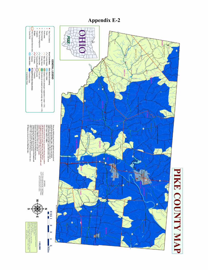
Appendix E-2

Appendix F-1

Appendix F-2
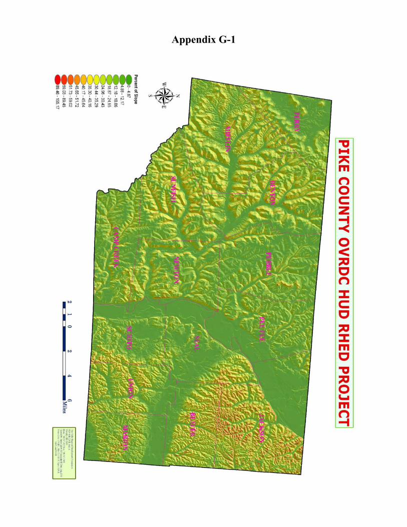
Appendix G-1

Appendix G-2

Appendix H

Appendix I-1

Appendix I-2

Appendix J-1

Appendix J-2

Appendix K-1

Appendix K-2

Appendix L-1

Appendix L-2

Appendix L-3

Appendix L-4

Appendix M-1

Appendix M-2

Appendix M-3

Appendix M-4
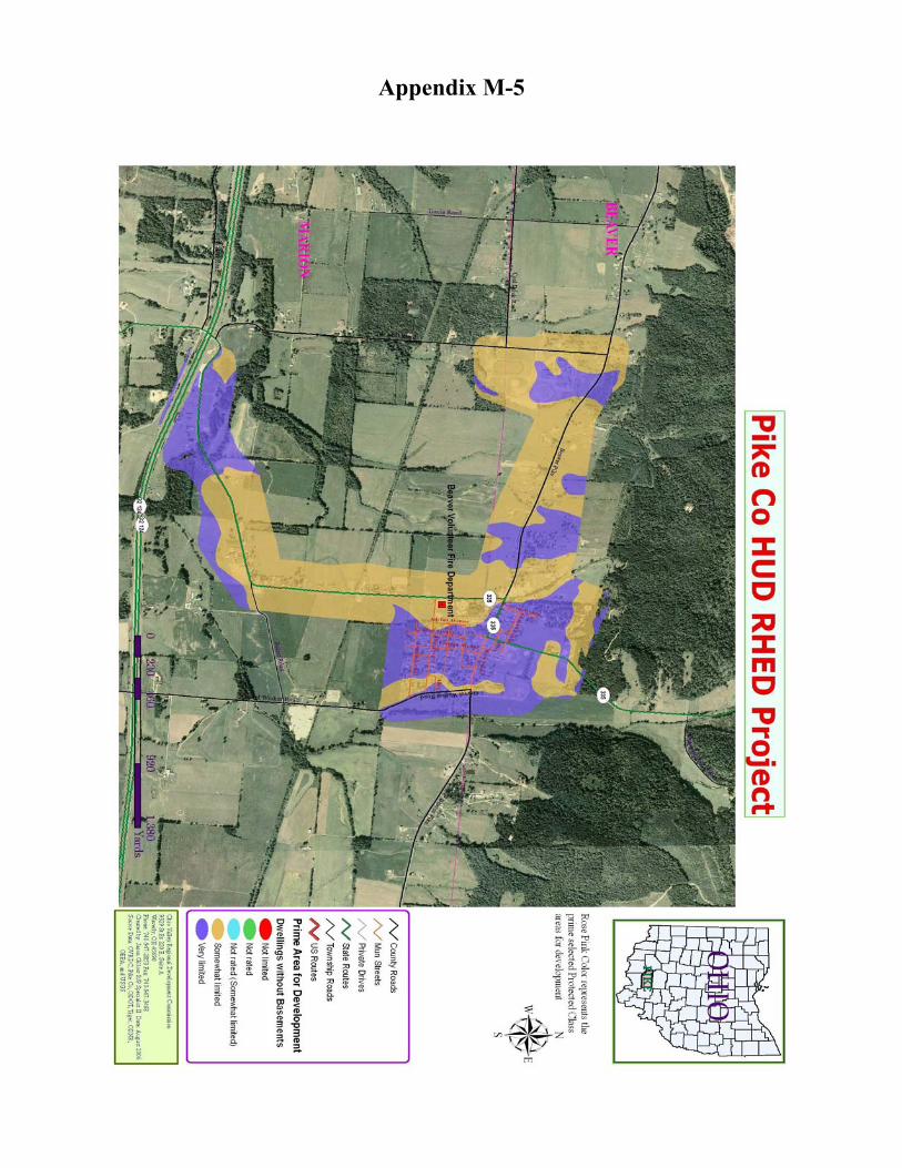
Appendix M-5

Appendix M-6

Appendix N-1

Appendix N-2

Appendix O

Appendix P-1

Appendix P-2

Ohio Valley Regional
Development Commission 9329 State Route 220 East, Suite A
Waverly, Ohio 45690-9012
Phone: 740-947-2853 or 800-223-7491 (in Ohio)
Fax: 740-947-3468
www.ovrdc.org [email protected]


