Planning for sites This section identifies land required over the period to 2031 to deliver the scale of growth and development set out in the previous chapters of this document. The role of this section of the Local Plan: strategy and sites document is to establish the principle that a suitable form of development can be located on a particular site, and to give that / those use(s) greater weight in determining planning applications and appeals on the site in question. However, it does not give permission to any particular proposal; this will still need to be achieved through the planning application process. The intention is to provide developers, service providers, the Council and residents with some certainty about what sites will be developed in the future and for what purpose. The allocation of a site does not necessarily mean that it will be developed straight away, although one of the intentions is to allocate sites which have the potential to enable development to take place without undue delay. As part of the evidence gathering, we asked developers, agents, landowners, parish councils and local residents to put forward sites that they wanted to be considered as potential allocations. We have considered these suggestions as we have prepared evidence base documents such as the SHLAA and ELA. The Local Plan Issues and Options consultation document included a summary and map of each potential development option at the time. At the time of consultation, some assessment of sites had been carried out (including that done in the SHLAA and ELA), but no decisions regarding site allocations had been made. The process for formulating policies and selecting sites is complex and has involved many considerations. The most important of these are: Evidence Base: All the development sites identified in this section are supported by an up to date, relevant and proportionate evidence base in accordance with the requirements of the National Planning Policy Framework (NPPF), the National Planning Policy Guidance (NPPG) and the Town and Country Planning (England) Regulations 2012. The key studies in the evidence base include the Green Belt and Countryside Study, Strategic Housing Land Availability Assessment (SHLAA), the Employment Land Assessment (ELA), the Viability Assessment, the Infrastructure Delivery Plan, the Options Growth Scenarios Transport Assessment Report, the Habitats Regulations Assessment (HRA) and the Strategic Flood Risk Assessment (SFRA). Sustainability Appraisal: This site allocations section and its preparation meet the requirements of the Strategic Environmental Assessment (SEA) Directive. The policies and sites identified in the plan are being appraised against sustainability objectives on an iterative basis. These iterations identify how emerging policies and allocations may help to achieve the relevant social, environmental and economic objectives. Duty to Co-operate: The Duty to Co-operate Statement, which forms part of the evidence base to the plan, demonstrates how the Council has co-operated effectively. Public Consultation: We are committed to involving the public in the decision-making process. In the preparation of this plan, we needed to balance its responsibility to
Transcript
Planning for sites This section identifies land required over the period to 2031 to deliver the scale of growth and development set out in the previous chapters of this document. The role of this section of the Local Plan: strategy and sites document is to establish the principle that a suitable form of development can be located on a particular site, and to give that / those use(s) greater weight in determining planning applications and appeals on the site in question. However, it does not give permission to any particular proposal; this will still need to be achieved through the planning application process. The intention is to provide developers, service providers, the Council and residents with some certainty about what sites will be developed in the future and for what purpose. The allocation of a site does not necessarily mean that it will be developed straight away, although one of the intentions is to allocate sites which have the potential to enable development to take place without undue delay. As part of the evidence gathering, we asked developers, agents, landowners, parish councils and local residents to put forward sites that they wanted to be considered as potential allocations. We have considered these suggestions as we have prepared evidence base documents such as the SHLAA and ELA. The Local Plan Issues and Options consultation document included a summary and map of each potential development option at the time. At the time of consultation, some assessment of sites had been carried out (including that done in the SHLAA and ELA), but no decisions regarding site allocations had been made. The process for formulating policies and selecting sites is complex and has involved many considerations. The most important of these are: Evidence Base: All the development sites identified in this section are supported by an up to date, relevant and proportionate evidence base in accordance with the requirements of the National Planning Policy Framework (NPPF), the National Planning Policy Guidance (NPPG) and the Town and Country Planning (England) Regulations 2012. The key studies in the evidence base include the Green Belt and Countryside Study, Strategic Housing Land Availability Assessment (SHLAA), the Employment Land Assessment (ELA), the Viability Assessment, the Infrastructure Delivery Plan, the Options Growth Scenarios Transport Assessment Report, the Habitats Regulations Assessment (HRA) and the Strategic Flood Risk Assessment (SFRA). Sustainability Appraisal: This site allocations section and its preparation meet the requirements of the Strategic Environmental Assessment (SEA) Directive. The policies and sites identified in the plan are being appraised against sustainability objectives on an iterative basis. These iterations identify how emerging policies and allocations may help to achieve the relevant social, environmental and economic objectives. Duty to Co-operate: The Duty to Co-operate Statement, which forms part of the evidence base to the plan, demonstrates how the Council has co-operated effectively. Public Consultation: We are committed to involving the public in the decision-making process. In the preparation of this plan, we needed to balance its responsibility to
involve the public in decision-making with its duty above all else, to plan positively for sustainable development. We have undertaken a considerable amount of public engagement and have taken on board the representations made during the plan preparation where appropriate. This is set out in the Statement of Consultation, which forms part of the evidence base. Each of the following sites are site allocations, and are numbered for reference. For each site, the allocated land use is identified. This section also includes information about safeguarded land. Some of this is safeguarded land in order to meet longer-term development needs stretching well beyond the plan period. This safeguarded land is not allocated for development at the present time. Safeguarding this land will help ensure that Green Belt boundaries do not need to be altered during the next plan period. Other land is safeguarded to provide for future transport infrastructure within the plan period.
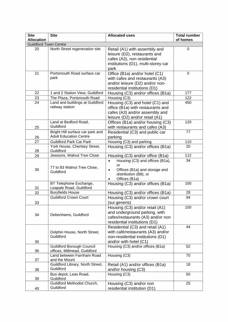
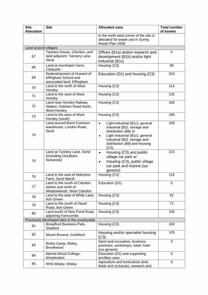
Site Allocation
Site Allocated uses Total number of homes
Guildford Town Centre 20 North Street regeneration site Retail (A1) with assembly and
leisure (D2), restaurants and cafes (A3), non residential institutions (D1), multi-storey car park
0
21 Portsmouth Road surface car park
Office (B1a) and/or hotel (C1) with cafes and restaurants (A3) and/or leisure (D2) and/or non-residential institutions (D1)
0
22 1 and 2 Station View, Guildford Housing (C3) and/or offices (B1a) 177 23 The Plaza, Portsmouth Road Housing (C3) 122 24 Land and buildings at Guildford
railway station Housing (C3) and hotel (C1) and office (B1a) with restaurants and cafes (A3) and/or assembly and leisure (D2) and/or retail (A1)
450
25 Land at Bedford Road, Guildford
Offices (B1a) and/or housing (C3) with restaurants and cafes (A3)
120
26 Bright Hill surface car park and Adult Education Centre
Residential (C3) and public car parking
77
27 Guildford Park Car Park Housing (C3) and parking 110
28 York House, Chertsey Street, Guildford
Housing (C3) and/or offices (B1a) 20
29 Jewsons, Walnut Tree Close Housing (C3) and/or office (B1a) 112
30 77 to 83 Walnut Tree Close, Guildford
• Housing (C3) and offices (B1a), or
• Offices (B1a) and storage and distribution (B8), or
• Offices (B1a)
34
31 BT Telephone Exchange, Leapale Road, Guildford
Housing (C3) and/or offices (B1a) 100
32 Buryfields House Housing (C3) and/or offices (B1a) 28
Housing (C3) and/or offices (B1a) or storage and distribution (B8)
35
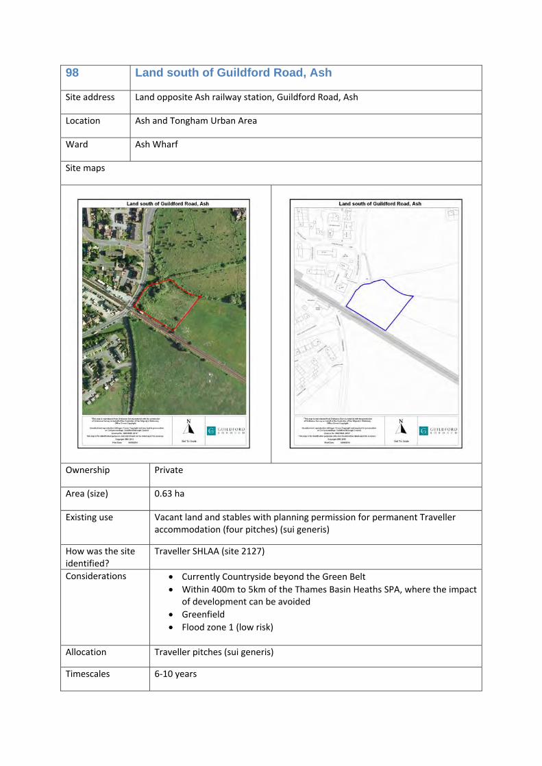
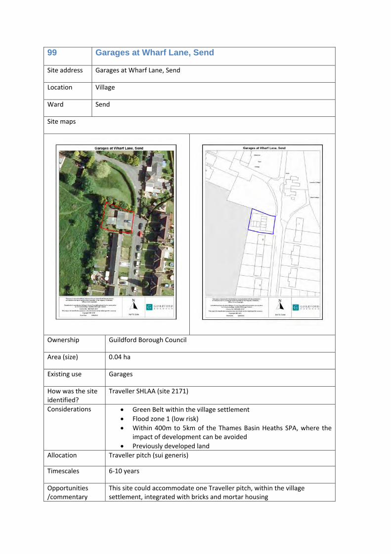
Ash and Tongham Urban Area
53 Ash Vehicle Centre, Ash Church Road, Ash
Housing (C3) 40
54 Public House, Oxenden Road, Tongham
Housing (C3) and/or public house (A4) with associated car parking
24
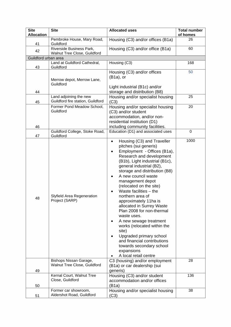
55 Tongham Triangle (Land at Grange Road, Tongham (bounded by A331 and A31)
Offices (B1a) and/or research and development (B1b) and/or light industrial (B1c) and/or general industrial (B2) and/or storage and distribution (B8)
0
56 Land in Ash and Tongham Housing (C3) 1500 Within villages
57 East Horsley countryside depot and BT telephone exchange, East Horsley
Housing (C3) or Housing (C3) and Traveller pitch (sui generis)
22
58 Hotel, Guildford Road, East Horsley
Housing and/or specialist housing (C3) and/or hotel (C1)
48
Land around Guildford urban area
59 Gosden Hill Farm, Guildford
Housing (C3), Traveller pitches (sui generis), employment uses (B1a, B1b and B1c), Park and Ride, railway station, open space, education, local retail centre (A1, A2 and A3), community and health services buildings (D1).
2000
60 Blackwell Farm, Guildford
Housing (C3), Employment use (B1a, B1b, B1c, B2, B8), Traveller pitches (sui generis), open space, Park and Ride, railway station, education, local retail centre (A1, A2 and A3), community and health services buildings (D1).
2250
61 Land north of Keens Lane, Guildford
Housing (C3) and care home (C2) 140
62 Land at Liddington Hall, Guildford
Housing (C3) and Traveller pitches (sui generis)
625
63 Land north of Slyfield Industrial Estate
Light industrial (B1c) and/or general industrial (B2) and/or, storage and distribution (B8)
0
64 Land at Gunners Farm and Bullens Hill Farm
Community football ground (D2) 0
65 Land north of Salt Box Road, Guildford
Education (D1) 0
New settlement
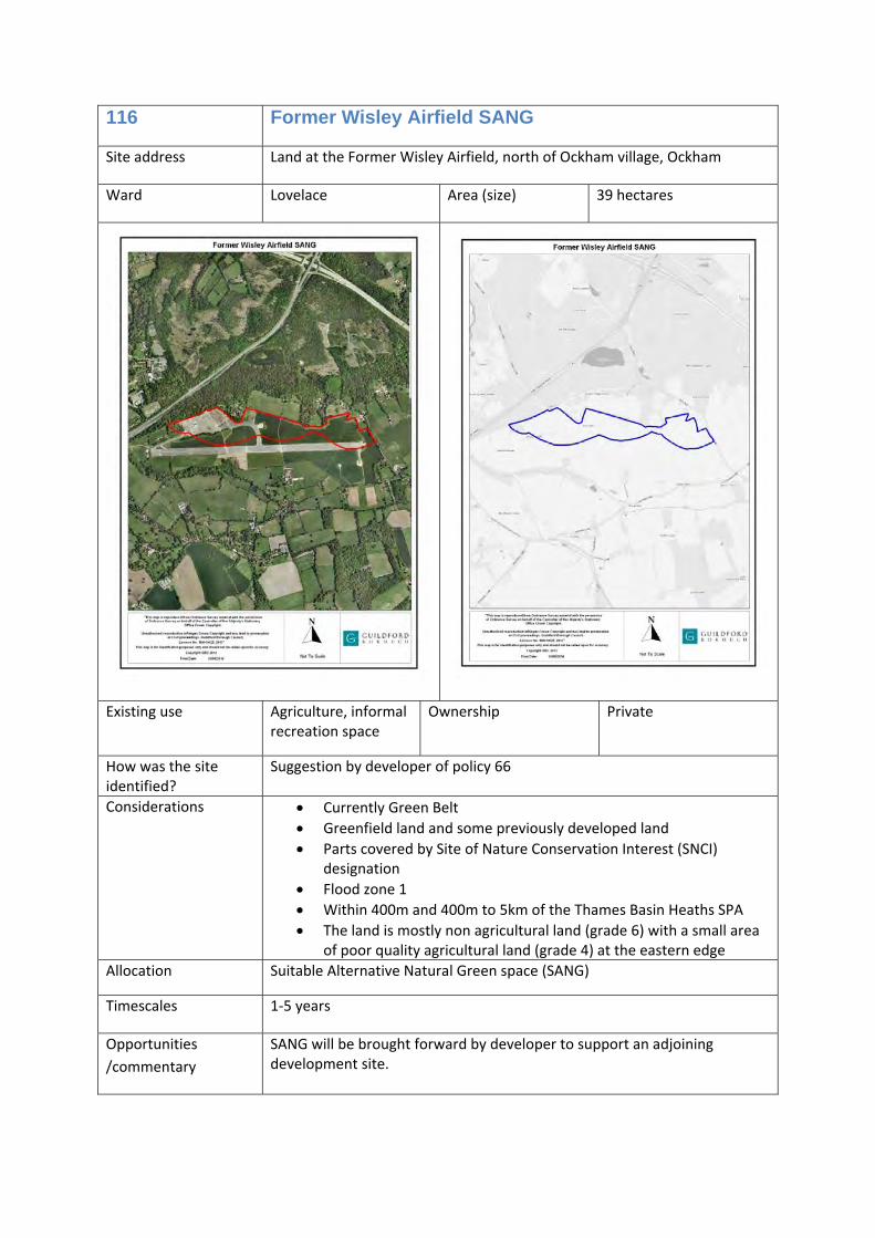
66 Land at the former Wisley airfield
Housing (C3), Traveller pitches (sui generis), Employment use ‐ Offices (B1a), Research and development (B1b), Light industrial (B1c), general industrial (B2), storage and distribution (B8), education, community and health services buildings (D1), open space. 16.98ha
up to 2100
Site Allocation
Site Allocated uses Total number of homes
in the north west corner of the site is allocated for waste use in Surrey Waste Plan 2008
Land around villages
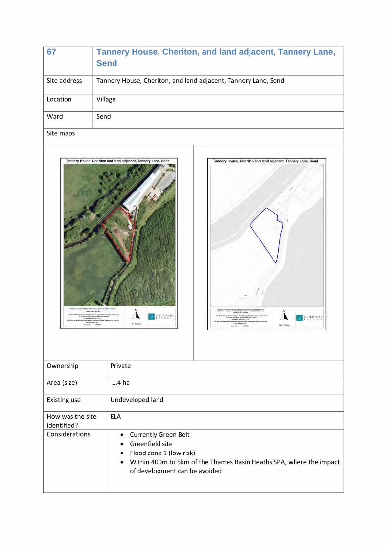
67 Tannery House, Cheriton, and land adjacent, Tannery Lane, Send
Offices (B1a) and/or research and development (B1b) and/or light industrial (B1c)
0
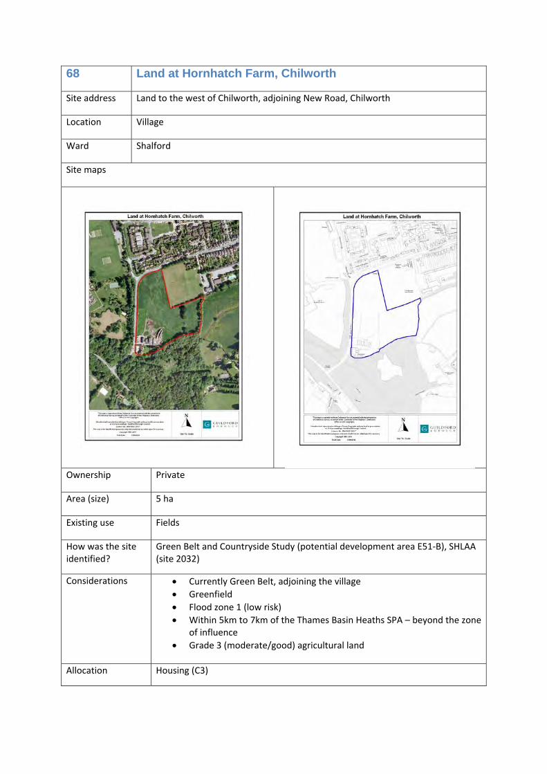
68 Land at Hornhatch Farm, Chilworth
Housing (C3) 80
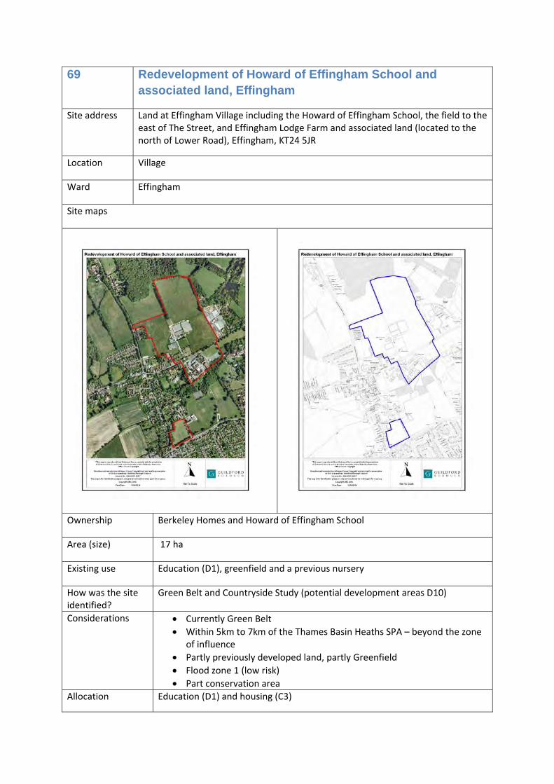
69 Redevelopment of Howard of Effingham School and associated land, Effingham
Education (D1) and housing (C3) 310
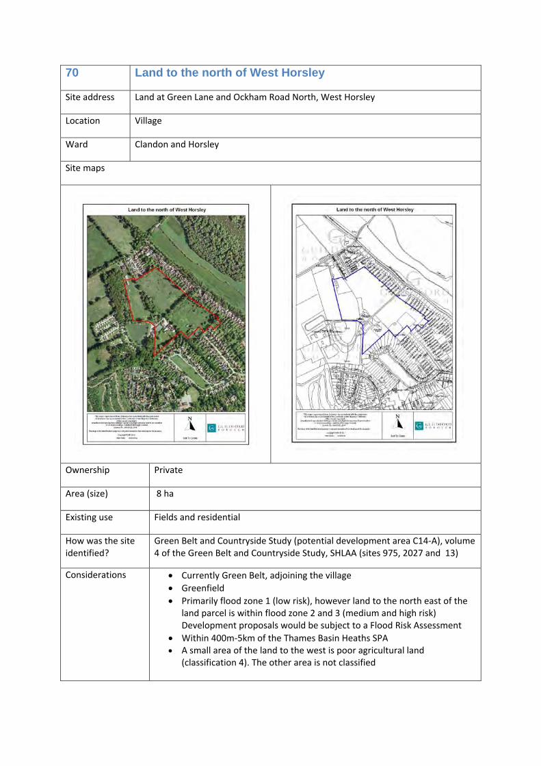
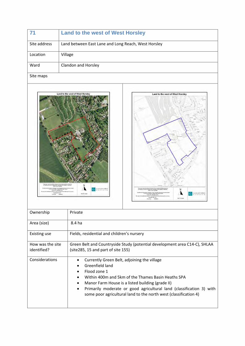
70 Land to the north of West Horsley
Housing (C3) 114
71 Land to the west of West Horsley
Housing (C3) 135
72 Land near Horsley Railway Station, Ockham Road North, West Horsley
Housing (C3) 100
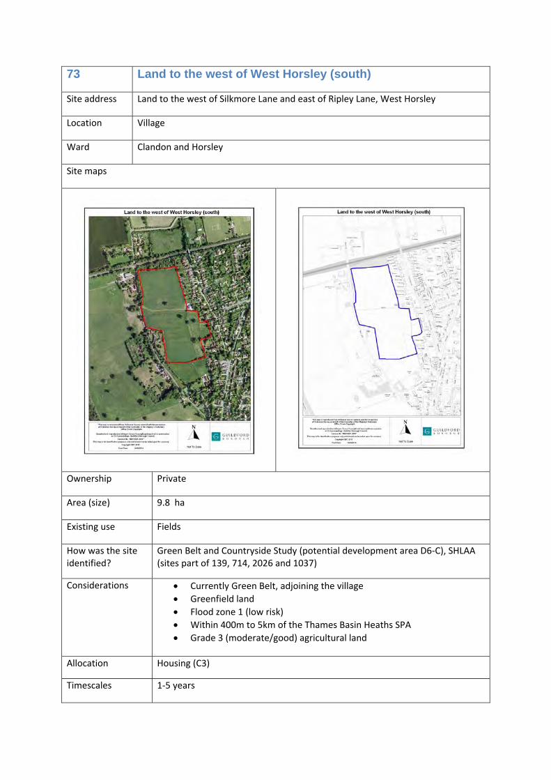
73 Land to the west of West Horsley (south)
Housing (C3) 185
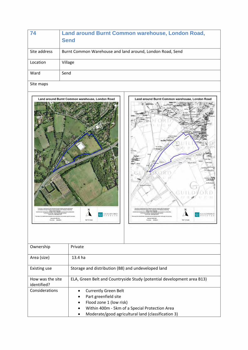
74
Land around Burnt Common warehouse, London Road, Send
• Light industrial (B1c), general industrial (B2), storage and distribution (B8) or
• Light industrial (B1c), general industrial (B2), storage and distribution (B8) and housing (C3)
100
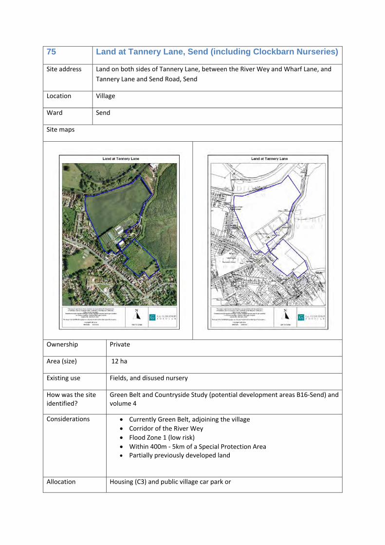
75
Land at Tannery Lane, Send (including Clockbarn Nurseries)
• Housing (C3) and public village car park or
• Housing (C3), public village car park and marina (sui generis)
215
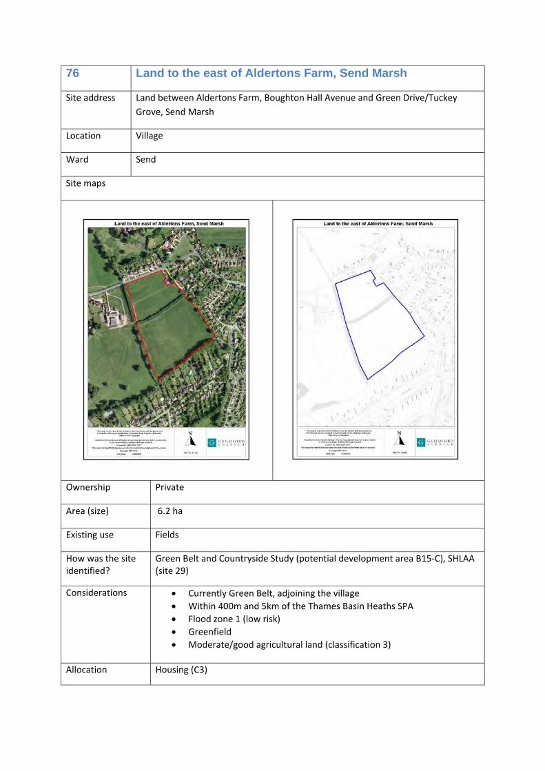
76 Land to the east of Aldertons Farm, Send Marsh
Housing (C3) 116
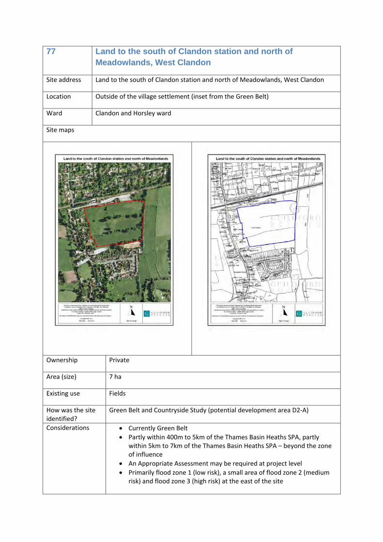
77 Land to the south of Clandon station and north of Meadowlands, West Clandon
Education (D1) 0
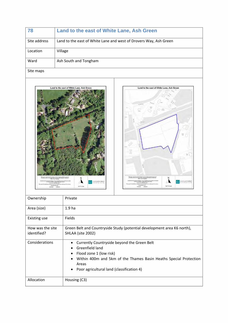
78 Land to the east of White Lane, Ash Green
Housing (C3) 62
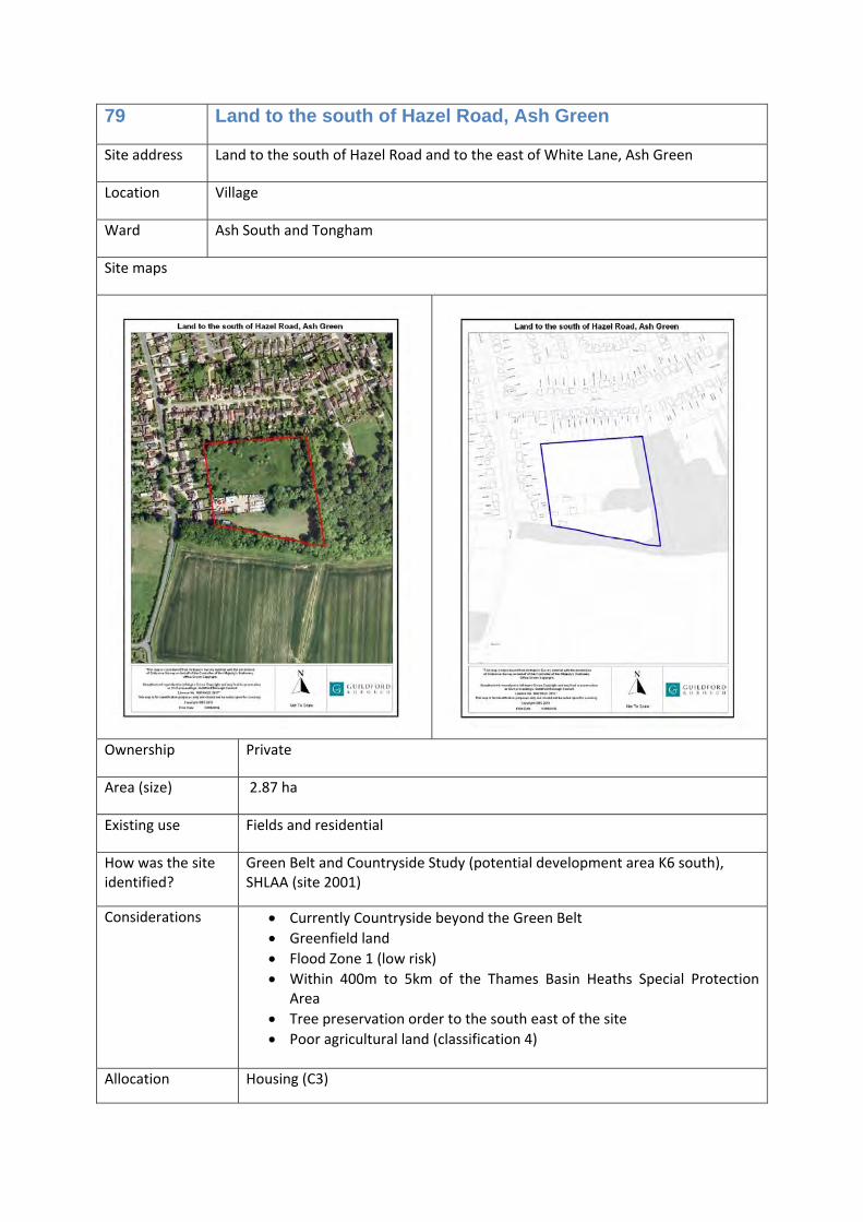
79 Land to the south of Hazel Road, Ash Green
Housing (C3) 71
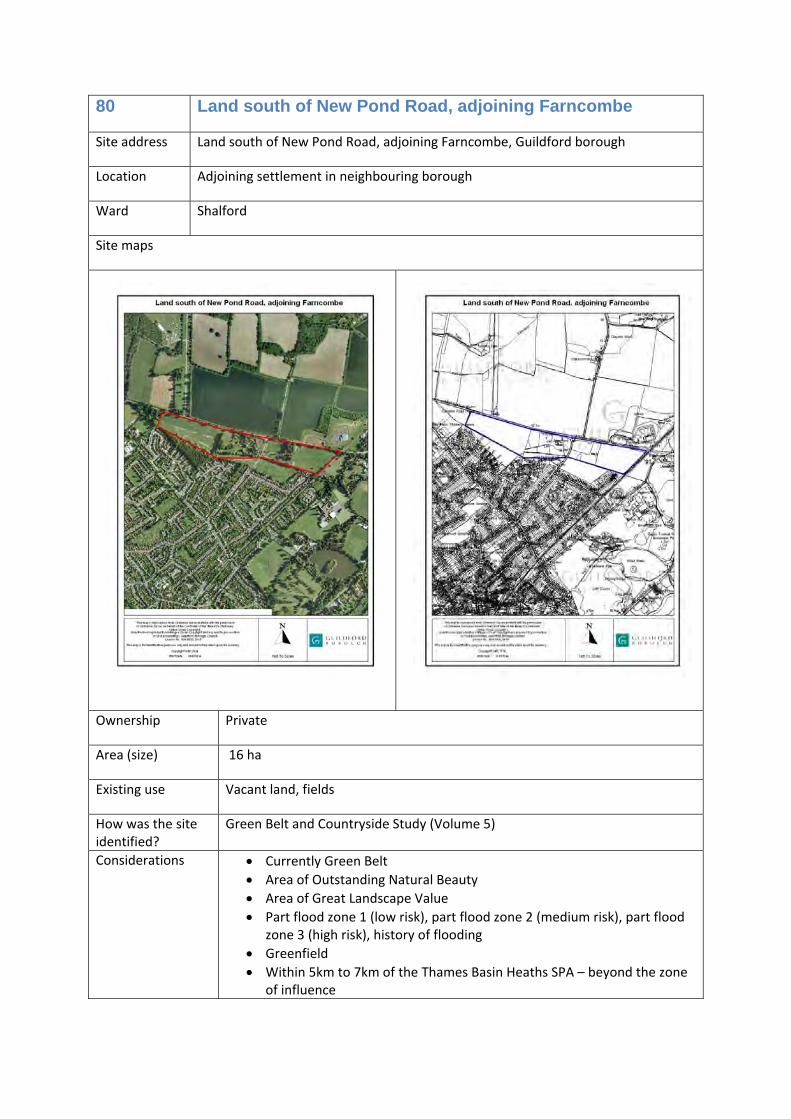
80 Land south of New Pond Road, adjoining Farncombe
Housing (C3) 100
Previously developed sites in the countryside
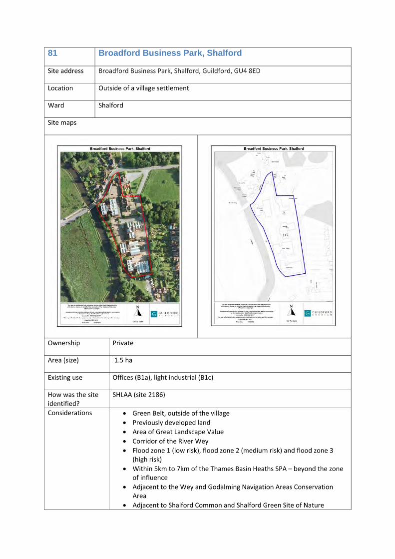
81 Broadford Business Park, Shalford
Housing (C3) 100
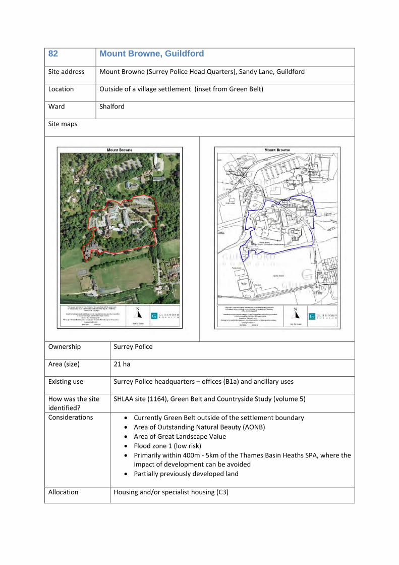
82 Mount Browne, Guildford Housing and/or specialist housing (C3)
125
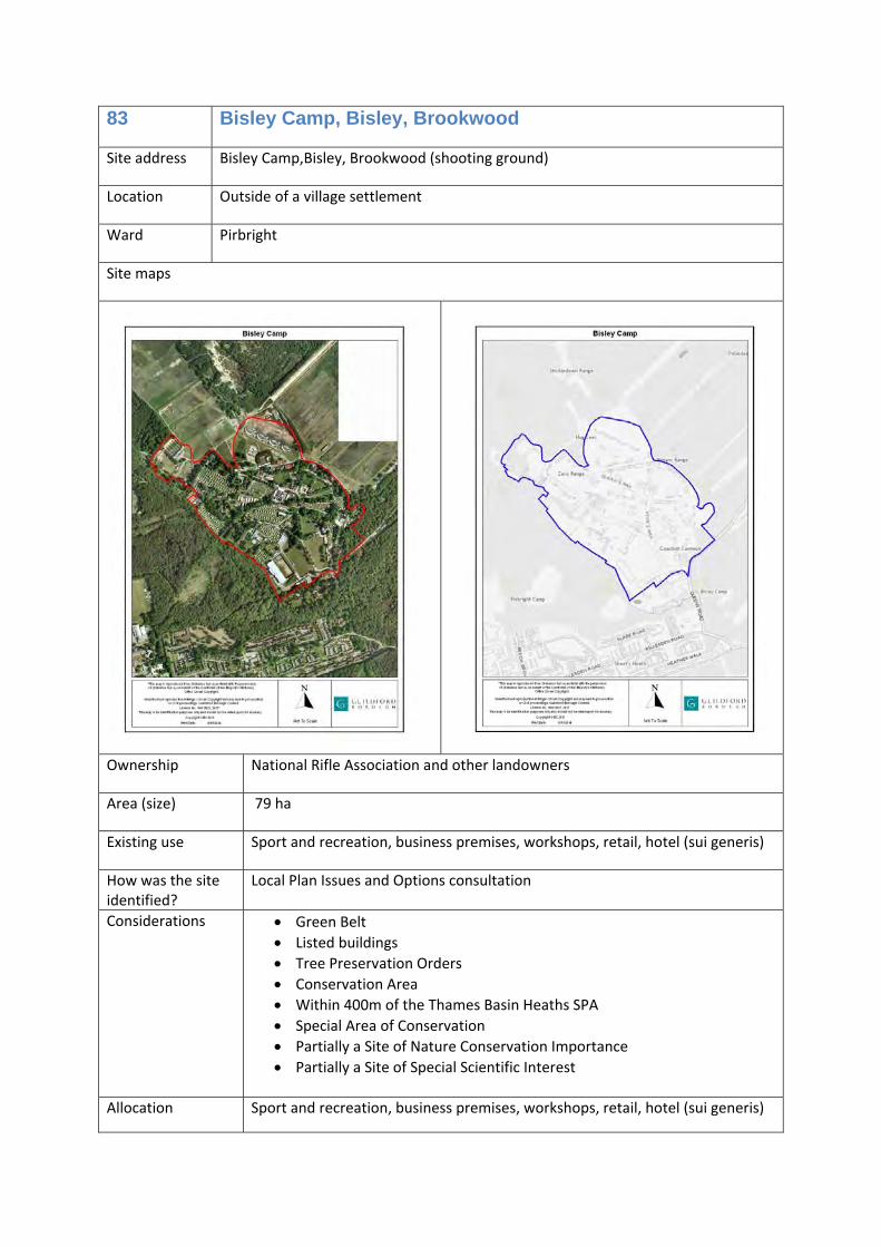
83 Bisley Camp, Bisley, Brookwood
Sport and recreation, business premises, workshops, retail, hotel (sui generis)
0
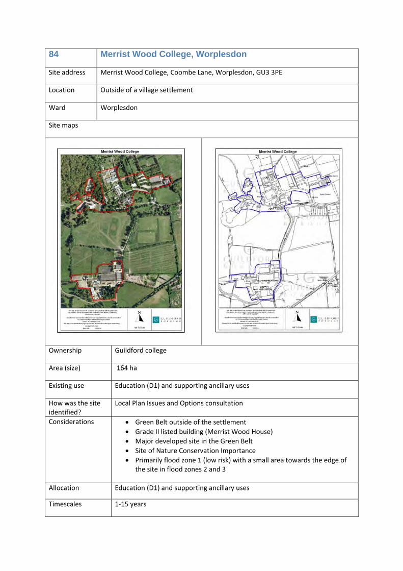
84 Merrist Wood College, Worplesdon
Education (D1) and supporting ancillary uses
0
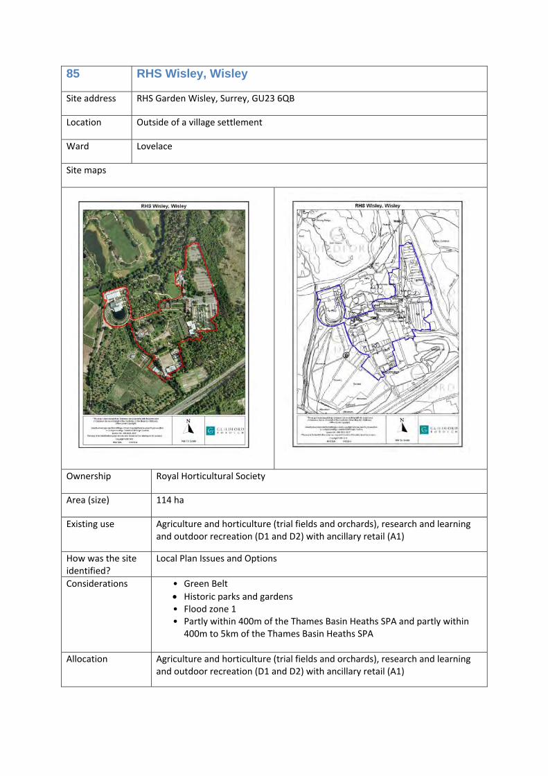
85 RHS Wisley, Wisley Agriculture and horticulture (trial fields and orchards), research and
0
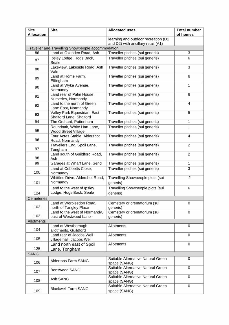
Site Allocation
Site Allocated uses Total number of homes
learning and outdoor recreation (D1 and D2) with ancillary retail (A1)
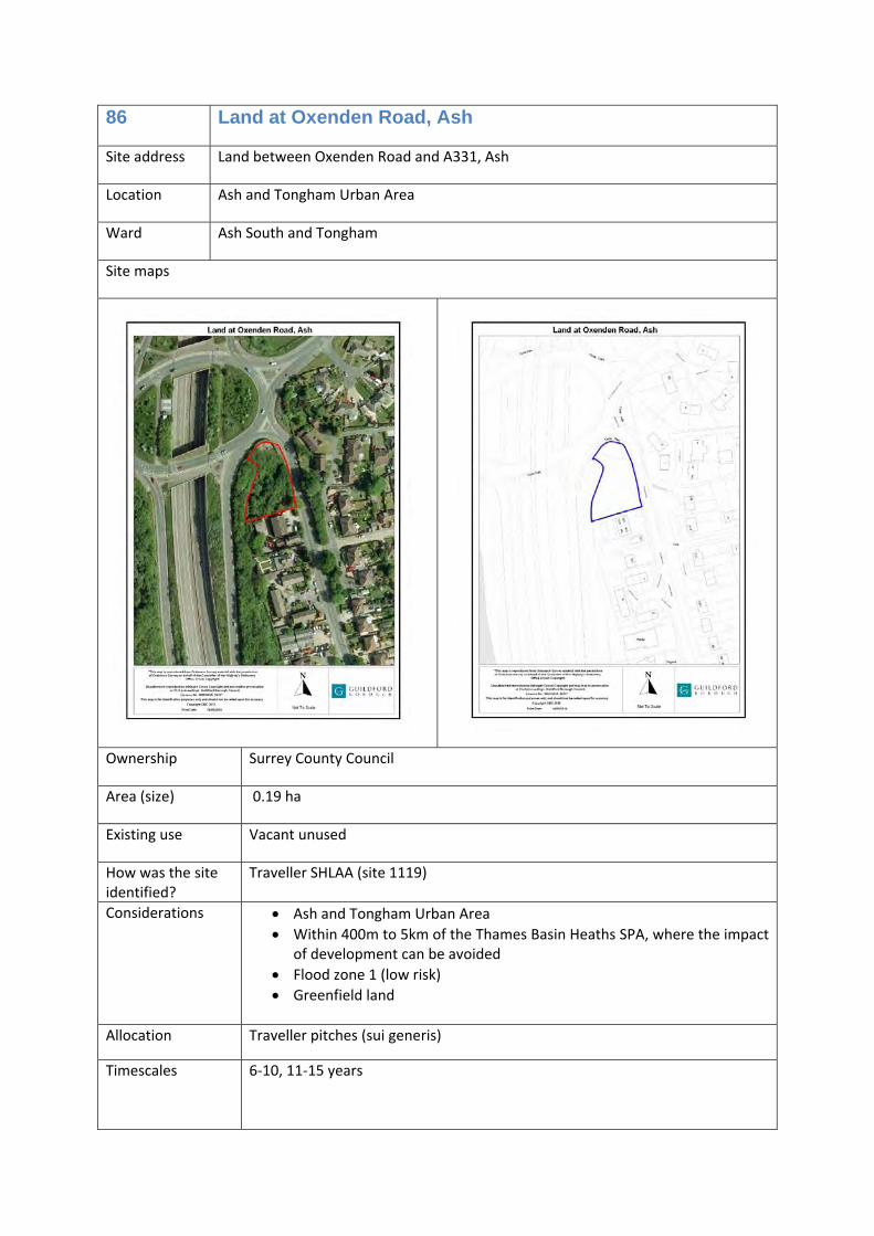
Traveller and Travelling Showpeople accommodation 86 Land at Oxenden Road, Ash Traveller pitches (sui generis) 3
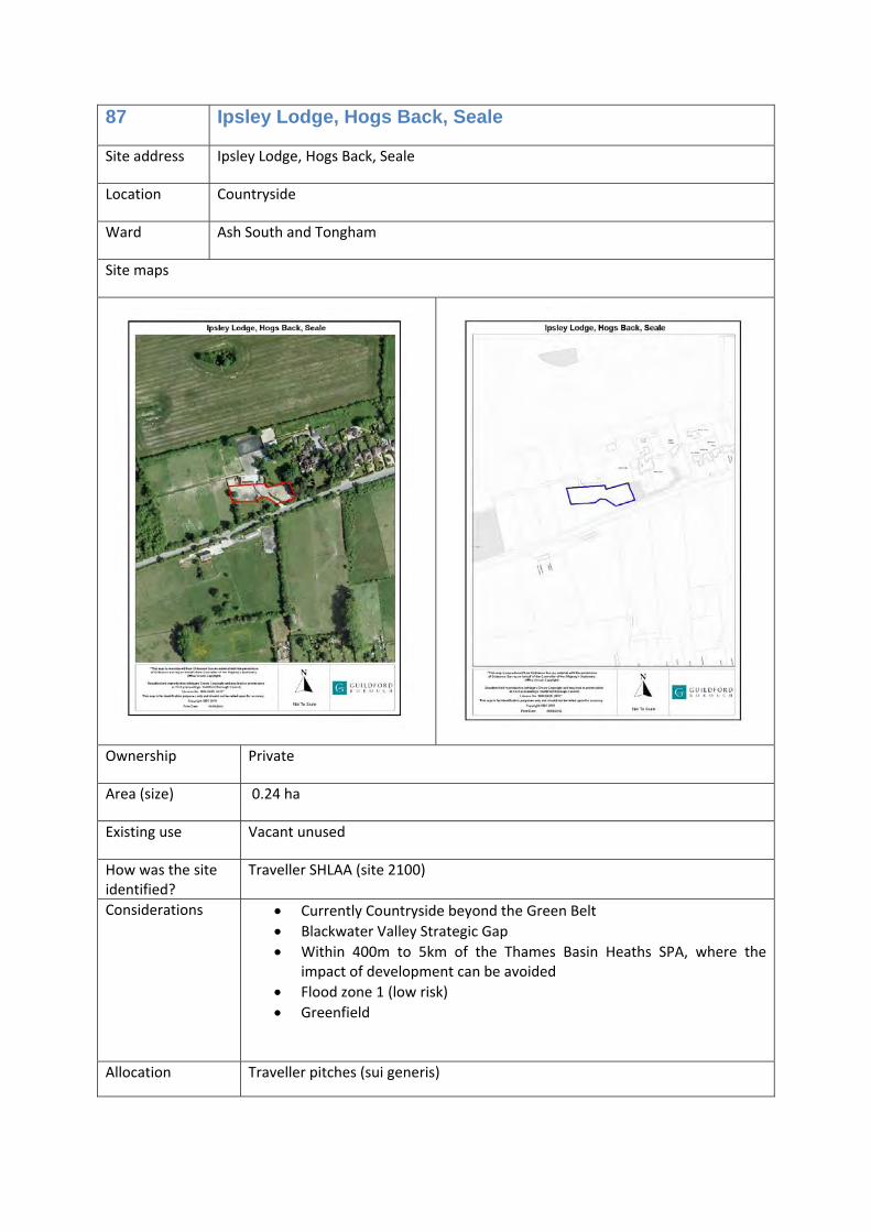
87 Ipsley Lodge, Hogs Back, Seale
Traveller pitches (sui generis) 6
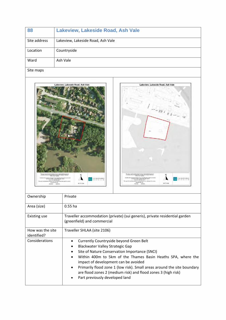
88 Lakeview, Lakeside Road, Ash Vale
Traveller pitches (sui generis) 3
89 Land at Home Farm, Effingham
Traveller pitches (sui generis) 6
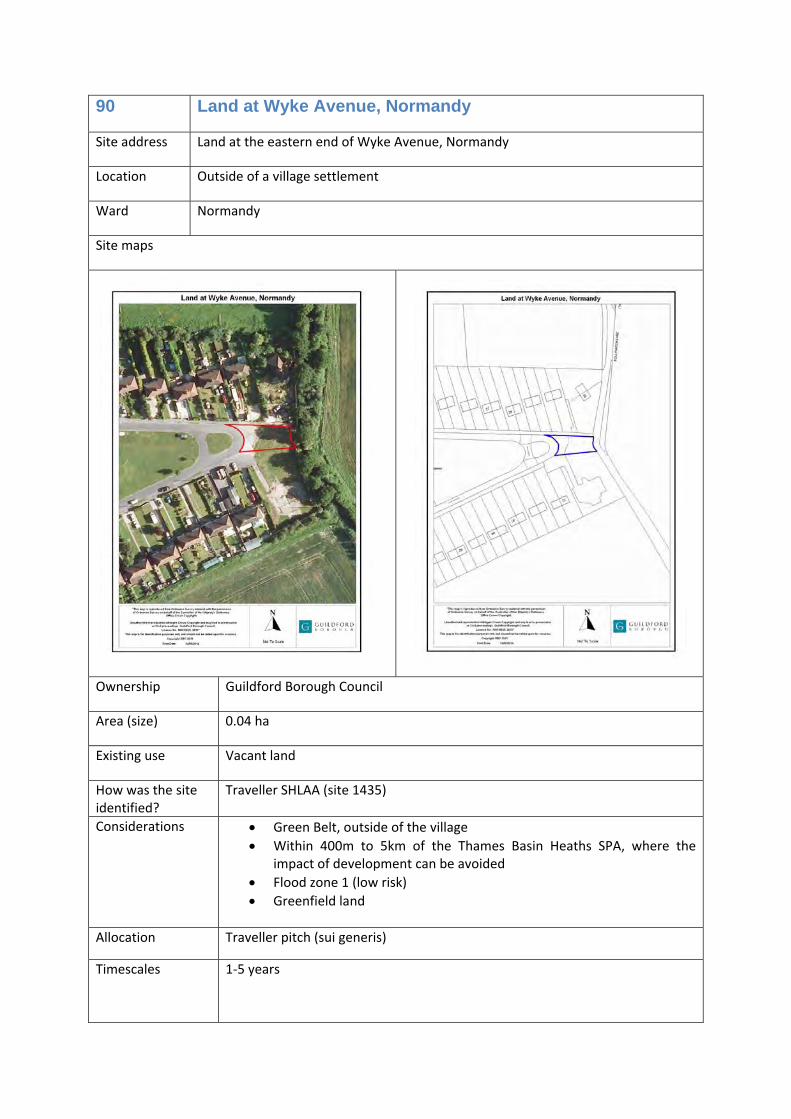
90 Land at Wyke Avenue, Normandy
Traveller pitches (sui generis) 1
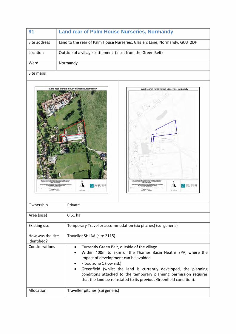
91 Land rear of Palm House Nurseries, Normandy
Traveller pitches (sui generis) 6
92 Land to the north of Green Lane East, Normandy
Traveller pitches (sui generis) 4
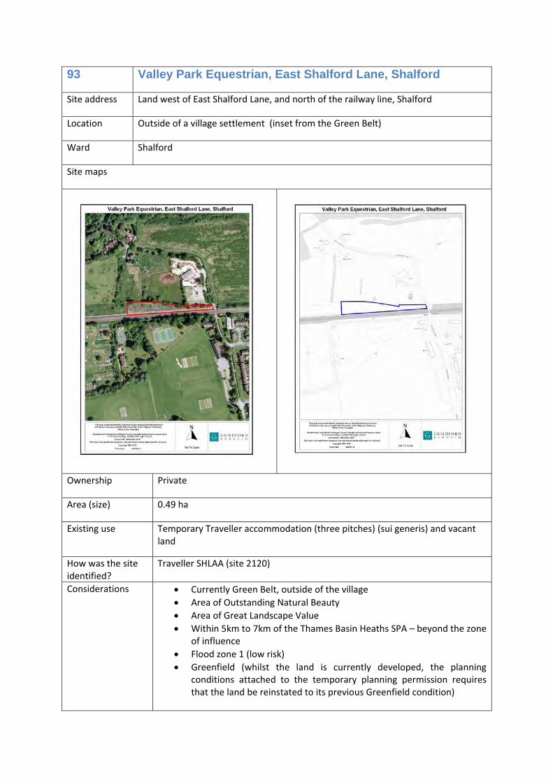
93 Valley Park Equestrian, East Shalford Lane, Shalford
Traveller pitches (sui generis) 5
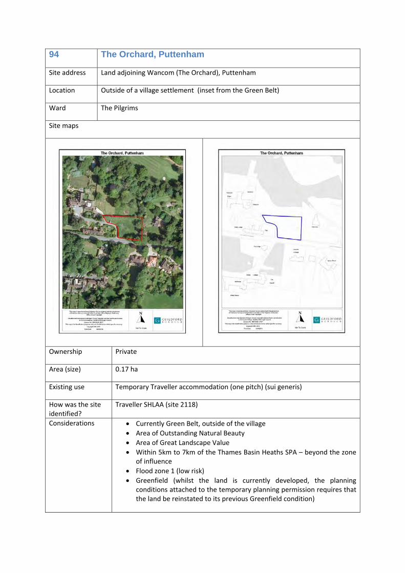
94 The Orchard, Puttenham Traveller pitches (sui generis) 1
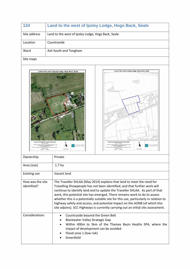
124 Land to the west of Ipsley Lodge, Hogs Back, Seale
Travelling Showpeople plots (sui generis)
6
Cemeteries
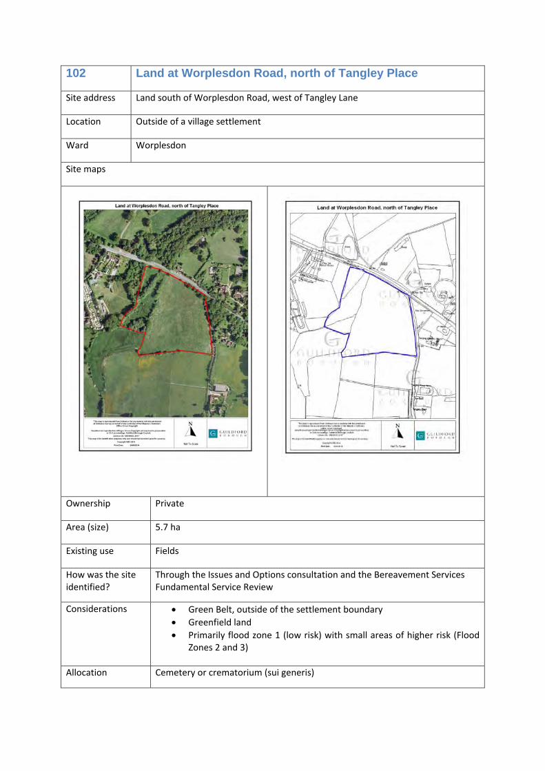
102 Land at Worplesdon Road, north of Tangley Place
Cemetery or crematorium (sui generis)
0
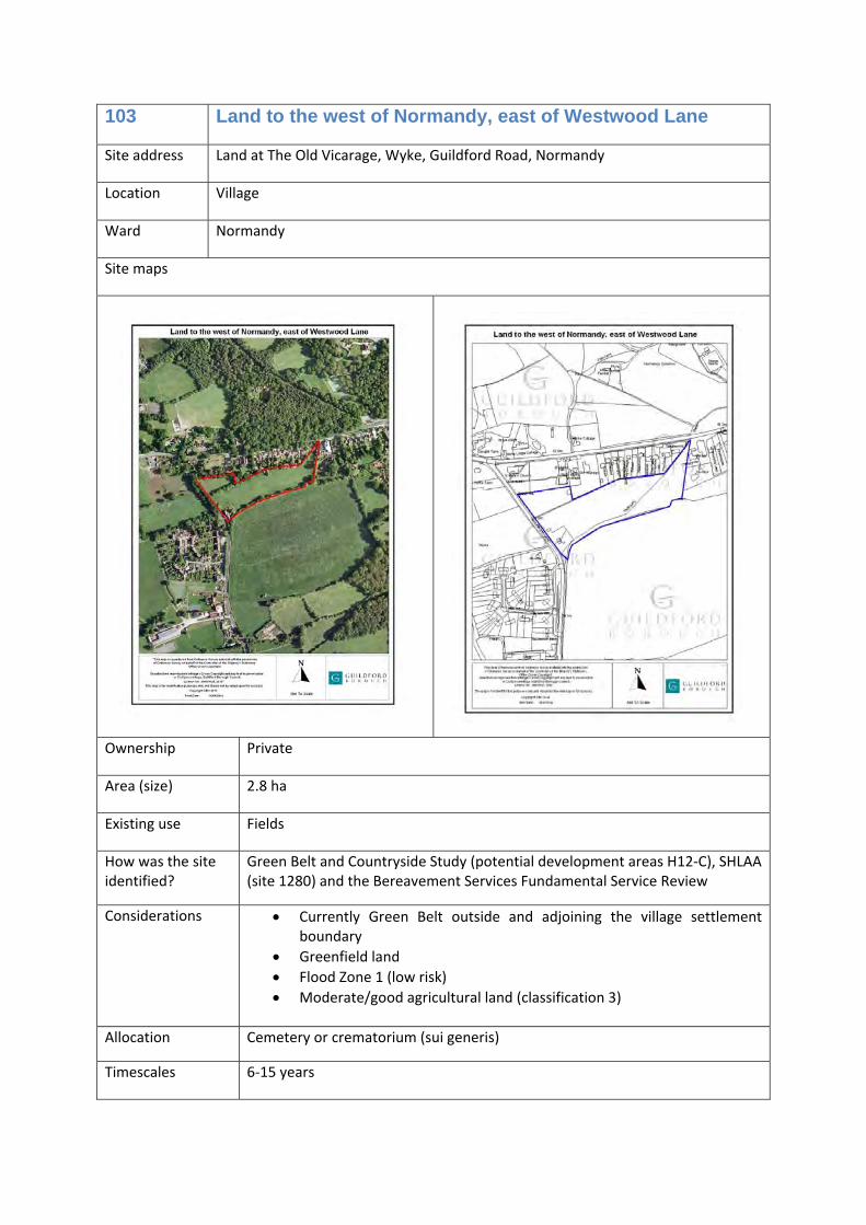
103 Land to the west of Normandy, east of Westwood Lane
Cemetery or crematorium (sui generis)
0
Allotments
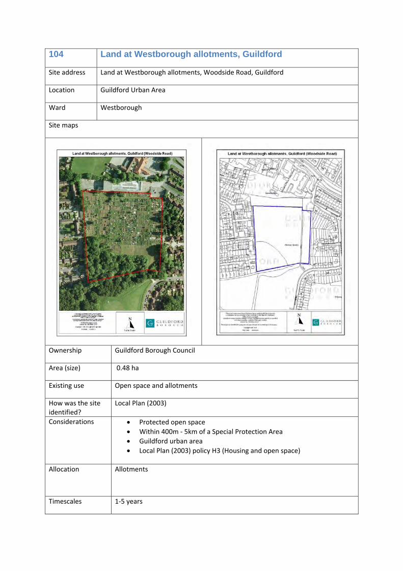
104 Land at Westborough allotments, Guildford
Allotments 0
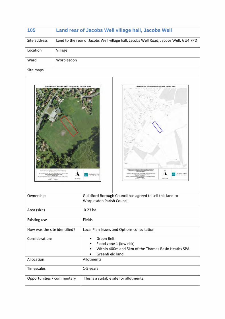
105 Land rear of Jacobs Well village hall, Jacobs Well
Allotments 0
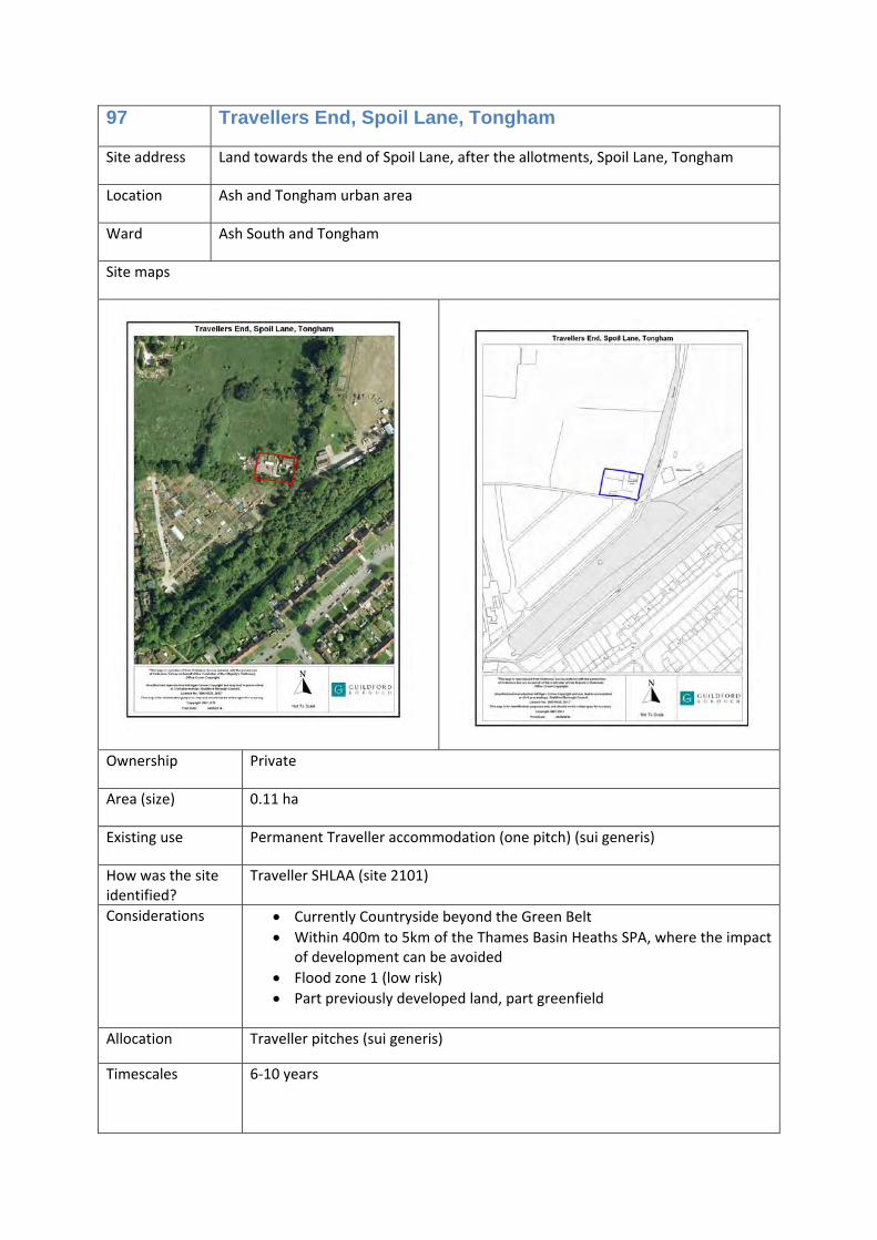
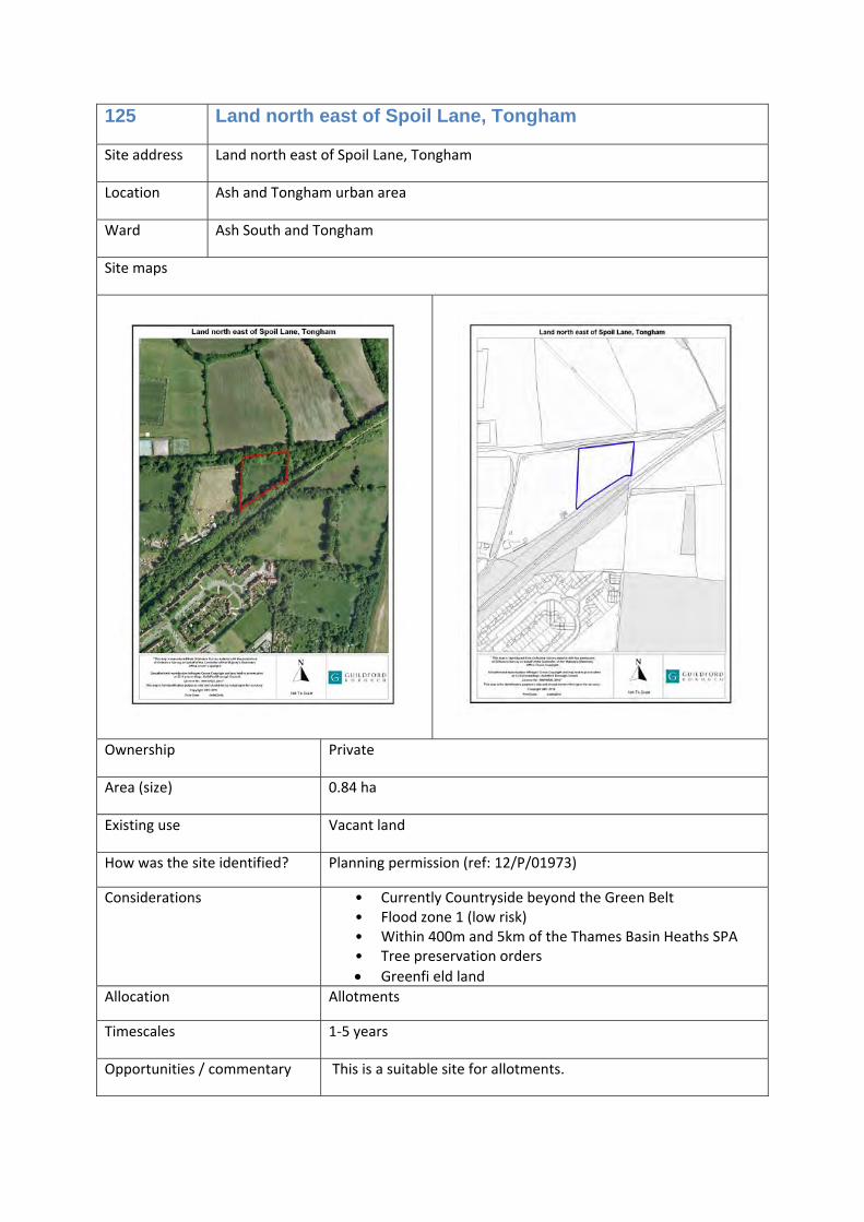
125 Land north east of Spoil Lane, Tongham
Allotments 0
SANG
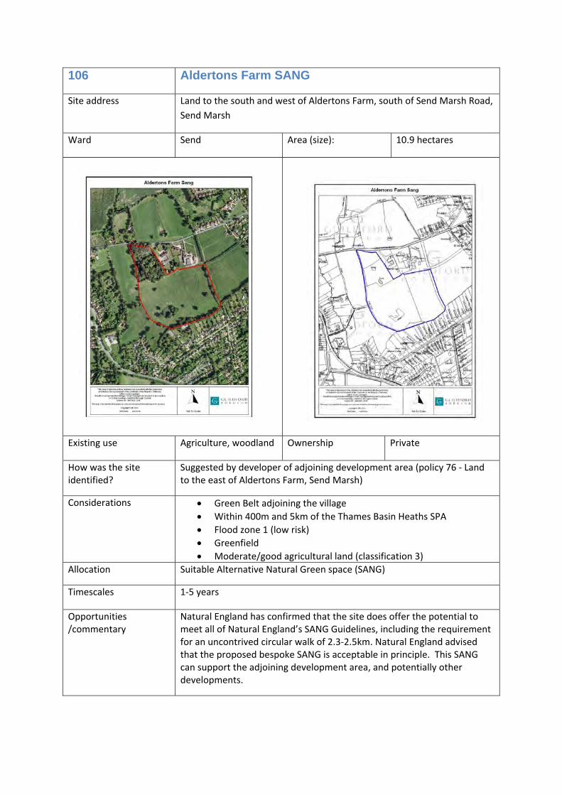
106 Aldertons Farm SANG Suitable Alternative Natural Green space (SANG)
0
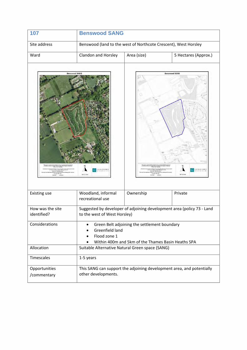
107 Benswood SANG Suitable Alternative Natural Green space (SANG)
0
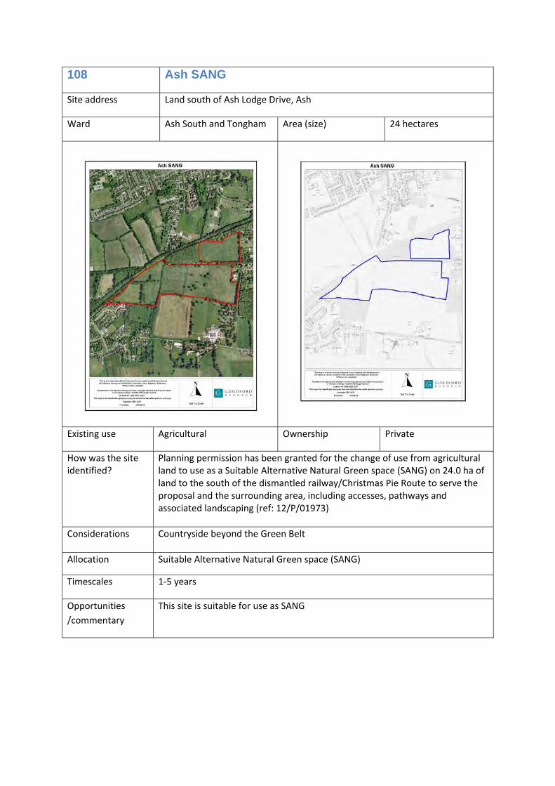
108 Ash SANG Suitable Alternative Natural Green space (SANG)
0
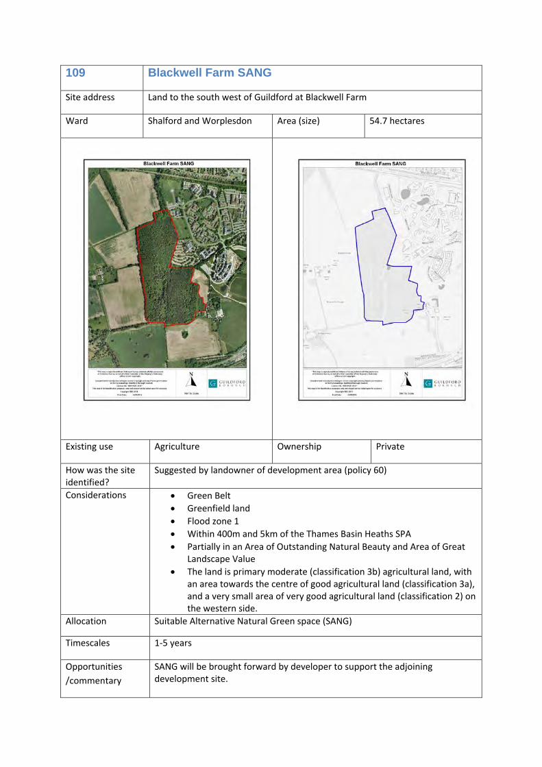
109 Blackwell Farm SANG Suitable Alternative Natural Green space (SANG)
0
Site Allocation
Site Allocated uses Total number of homes
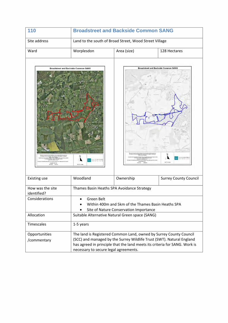
110 Broadstreet and Backside Common SANG
Suitable Alternative Natural Green space (SANG)
0
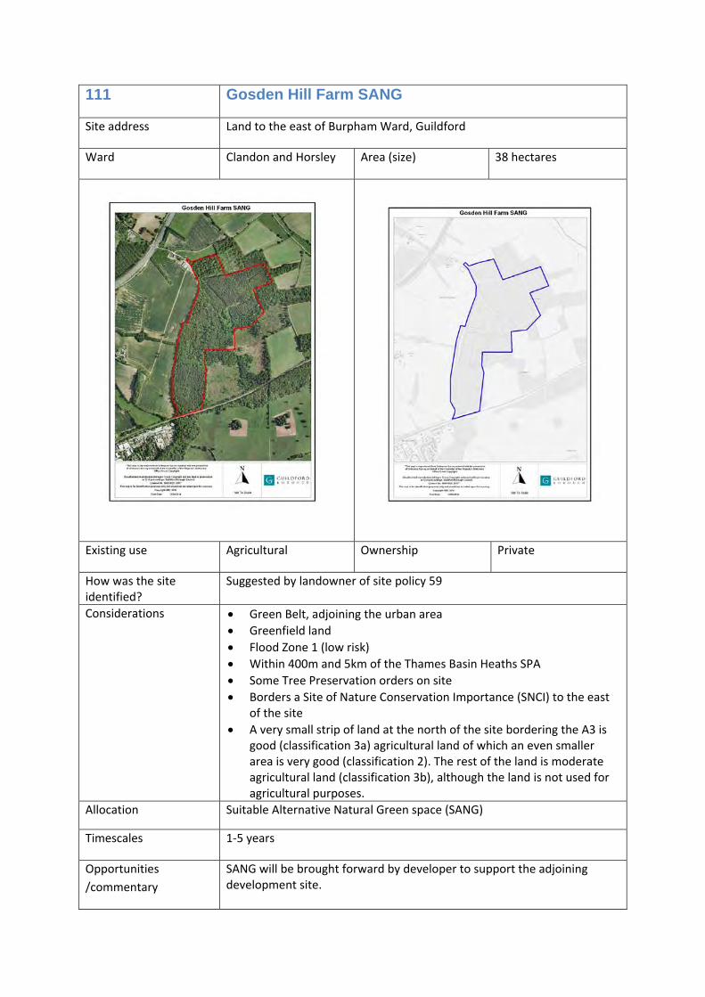
111 Gosden Hill Farm SANG Suitable Alternative Natural Green space (SANG)
0
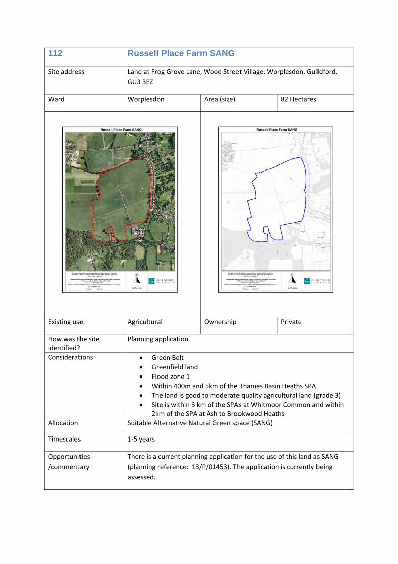
112 Russel Farm Place SANG Suitable Alternative Natural Green space (SANG)
0
113 Stringers Common SANG Suitable Alternative Natural Green space (SANG)
0
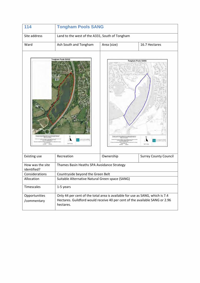
114 Tongham Pools SANG Suitable Alternative Natural Green space (SANG)
0
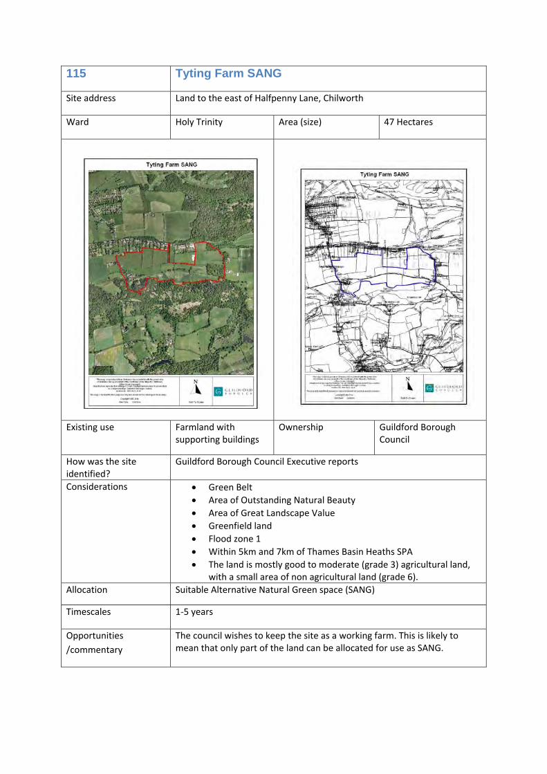
115 Tyting Farm SANG Suitable Alternative Natural Green space (SANG)
0
116 Former Wisley Airfield SANG Suitable Alternative Natural Green space (SANG)
0
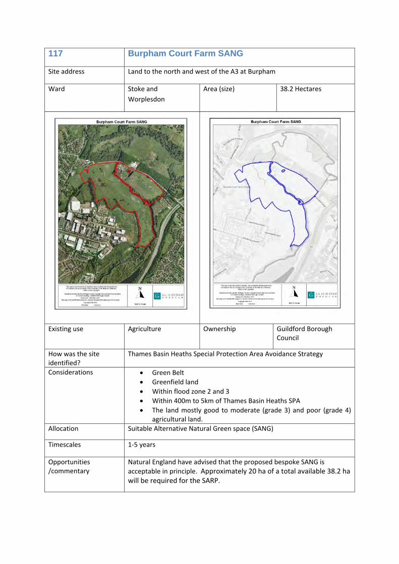
117 Burpham Court Farm SANG
Suitable Alternative Natural Green space (SANG)
0
Safeguarded land
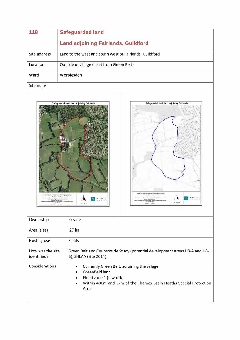
118 Land adjoining Fairlands, Guildford
N/a N/a
119 Land between Normandy and Flexford
N/a N/a
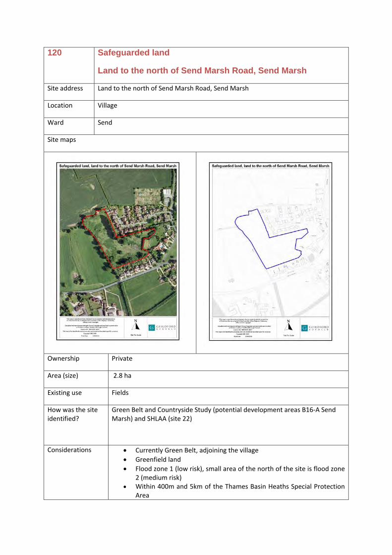
120 Land to the north of Send Marsh Road, Send Marsh
N/a N/a
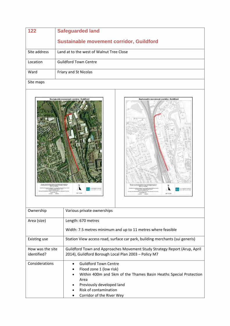
121 Clay Lane link road, Guildford N/a N/a 122 Sustainable movement corridor N/a N/a
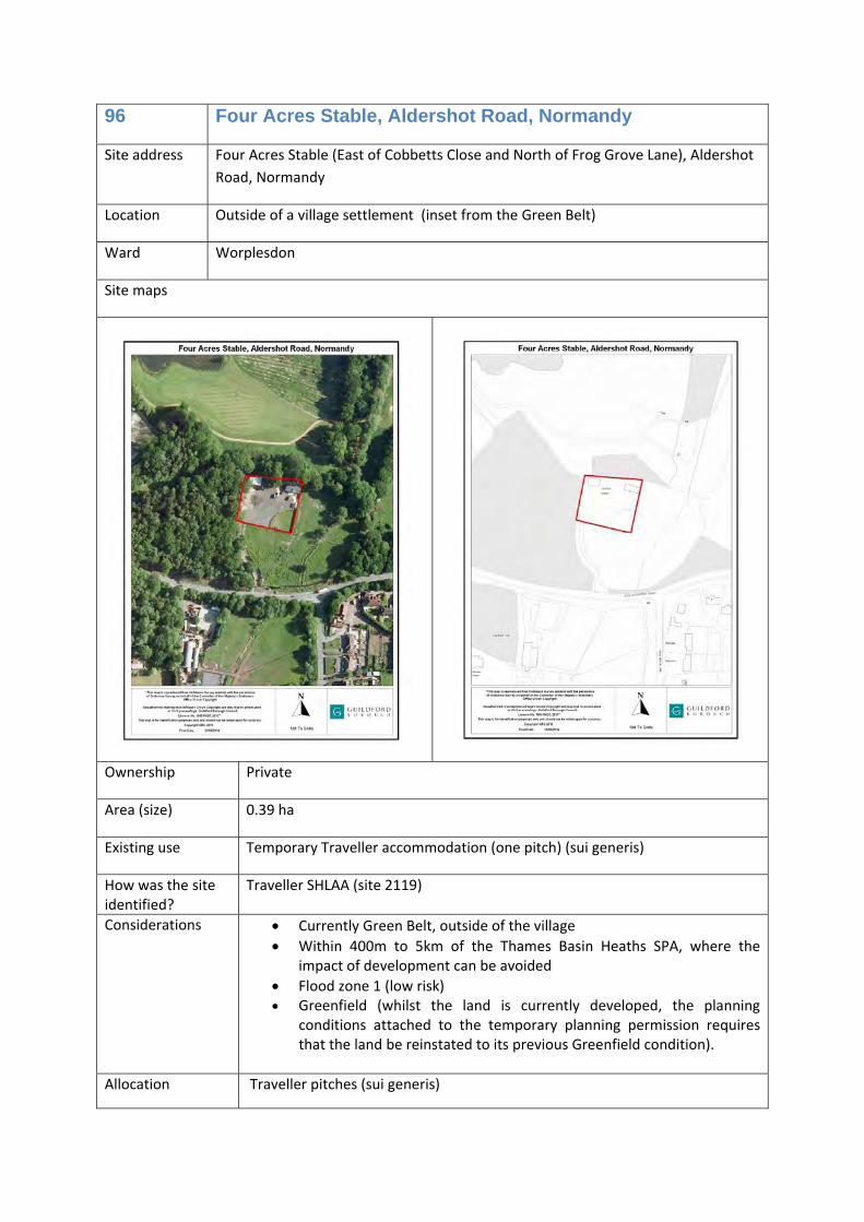
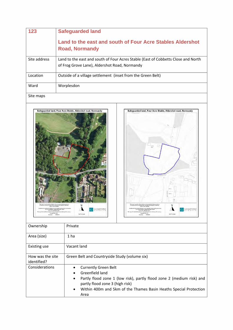
123 Land to the east and south of Four Acre Stables Aldershot Road, Normandy
N/a N/a
20 North Street regeneration site
Site address Land bounded by North Street, Onslow Street and Leapale Road, Guildford, Surrey, GU1
Location Guildford Town Centre
Ward Friary and St Nicolas
Site maps
Ownership Guildford Borough Council and private landowner
Area (size) 2.52 ha
Existing use Surface car parks (short stay), multi‐storey car park, bar, housing, shops, bank, offices, Citizen’s Advice Bureau
How was the site identified?
There is a long standing ambition to redevelop this land. In 2004, planning permission was granted for a comprehensive mixed use redevelopment to provide up to a maximum of 170 residential units, shops (Class A1), professional and financial units (Class A2), restaurants and cafes (Class A3), community space (Class D1), replacement bus station, a public square, residential car parking, servicing, plant, the refurbishment of existing Friary Centre and ancillary works. The length of this permission was extended, but has since expired.
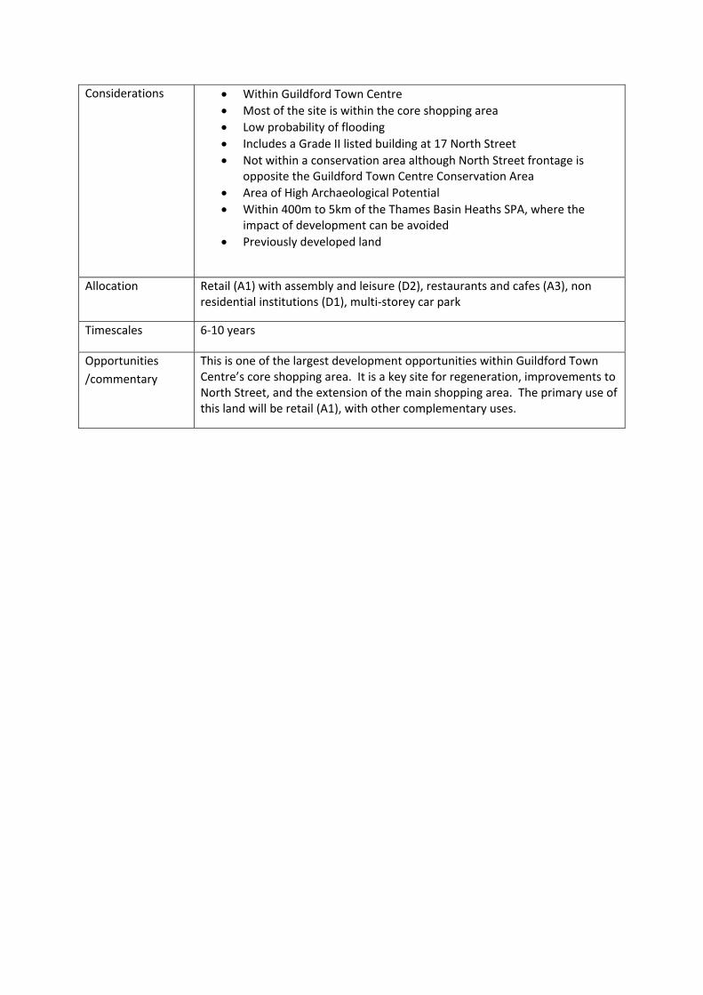
Considerations • Within Guildford Town Centre • Most of the site is within the core shopping area • Low probability of flooding • Includes a Grade II listed building at 17 North Street • Not within a conservation area although North Street frontage is
opposite the Guildford Town Centre Conservation Area • Area of High Archaeological Potential • Within 400m to 5km of the Thames Basin Heaths SPA, where the
impact of development can be avoided • Previously developed land
Allocation Retail (A1) with assembly and leisure (D2), restaurants and cafes (A3), non residential institutions (D1), multi‐storey car park
Timescales 6‐10 years
Opportunities /commentary
This is one of the largest development opportunities within Guildford Town Centre’s core shopping area. It is a key site for regeneration, improvements to North Street, and the extension of the main shopping area. The primary use of this land will be retail (A1), with other complementary uses.
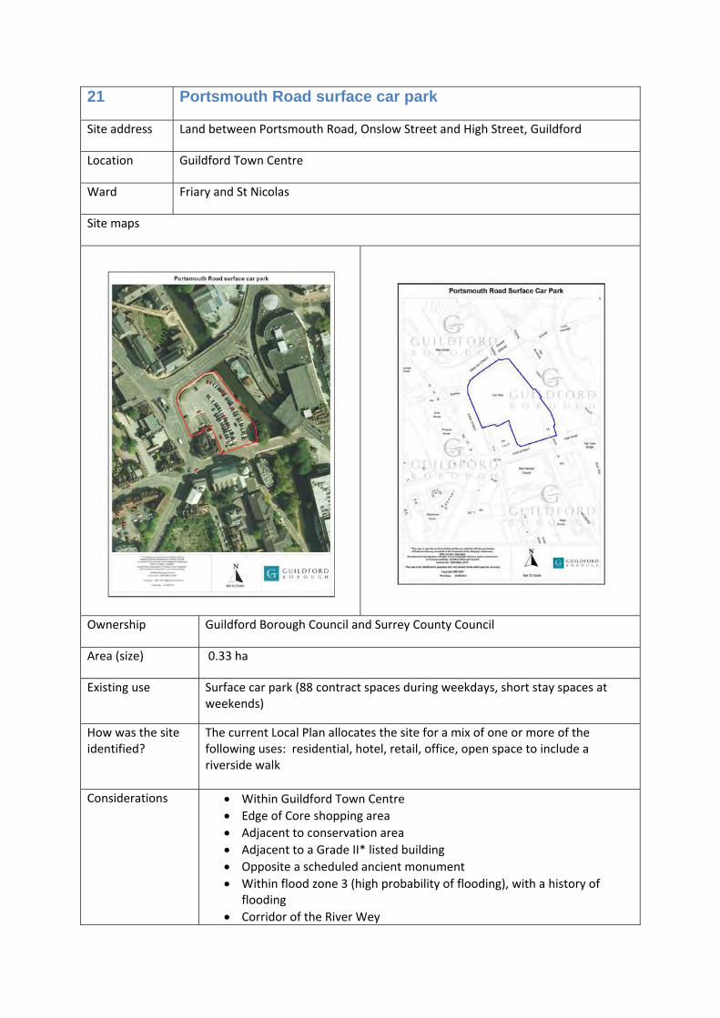
21 Portsmouth Road surface car park
Site address Land between Portsmouth Road, Onslow Street and High Street, Guildford
Location Guildford Town Centre
Ward Friary and St Nicolas
Site maps
Ownership Guildford Borough Council and Surrey County Council
Area (size) 0.33 ha
Existing use Surface car park (88 contract spaces during weekdays, short stay spaces at weekends)
How was the site identified?
The current Local Plan allocates the site for a mix of one or more of the following uses: residential, hotel, retail, office, open space to include a riverside walk
Considerations • Within Guildford Town Centre • Edge of Core shopping area • Adjacent to conservation area • Adjacent to a Grade II* listed building • Opposite a scheduled ancient monument • Within flood zone 3 (high probability of flooding), with a history of
flooding • Corridor of the River Wey
• Within 400m to 5km of the Thames Basin Heaths SPA, where the impact of development can be avoided
• Previously developed land
Allocation Office (B1a) and/or hotel (C1) with cafes and restaurants (A3) and/or leisure (D2) and/or non‐residential institutions (D1).
Uses less susceptible to flood risk should be located on the ground floor. Over night accommodation (C1) is not suitable on the ground floor due to flood risk.
Timescales 6‐10 years
Opportunities /commentary
This is a prominent site in Guildford’s town centre, situated between Guildford station and the core shopping area.
The site has a long riverside frontage, and its redevelopment could contribute significantly to improving the riverside.
A green open space running along the riverside could be created. This would provide for emergency flood water storage whilst creating a pleasant green area. It would also enhance the riverside and provide an attractive riverside walk between the railway station and the shops at the lower end of High Street. There is the potential to consider removing railings here, and possibly a few short‐stay visitor moorings.
A building stepping down in height to the river could be most suitable to screen the raised gyratory.
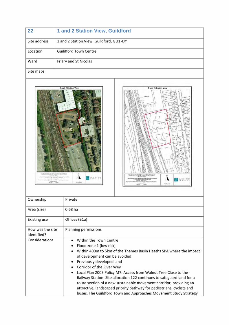
22 1 and 2 Station View, Guildford
Site address 1 and 2 Station View, Guildford, GU1 4JY
Location Guildford Town Centre
Ward Friary and St Nicolas
Site maps
Ownership Private
Area (size) 0.68 ha
Existing use Offices (B1a)
How was the site identified?
Planning permissions
Considerations • Within the Town Centre • Flood zone 1 (low risk) • Within 400m to 5km of the Thames Basin Heaths SPA where the impact
of development can be avoided • Previously developed land • Corridor of the River Wey • Local Plan 2003 Policy M7: Access from Walnut Tree Close to the
Railway Station. Site allocation 122 continues to safeguard land for a route section of a new sustainable movement corridor, providing an attractive, landscaped priority pathway for pedestrians, cyclists and buses. The Guildford Town and Approaches Movement Study Strategy
Report (Arup, April 2014) sets out the concept and identifies a potential route.
A planning permission to provide 177 new homes (flats) has technically commenced (06/p/02309, 09/P/01282), so the planning permission can be implemented at any time. There is also a planning permission for redevelopment of the site to provide a detached office block (use class B1) comprising part four storey and part five storey building with basement, car parking for 105 car parking spaces and associated landscaping following demolition of existing office blocks (13/P/00082).
Allocation Housing (C3) and/or offices (B1a)
Timescales 1‐5 years
Opportunities /commentary
This is a sustainable location for new modern offices, new homes, or a mix of both uses.
Site allocation 122 safeguards land for a route section of a new sustainable movement corridor, providing an attractive, landscaped priority pathway for pedestrians, cyclists and buses. The Guildford Town and Approaches Movement Study Strategy Report (Arup, April 2014) sets out the concept and identifies a potential route.
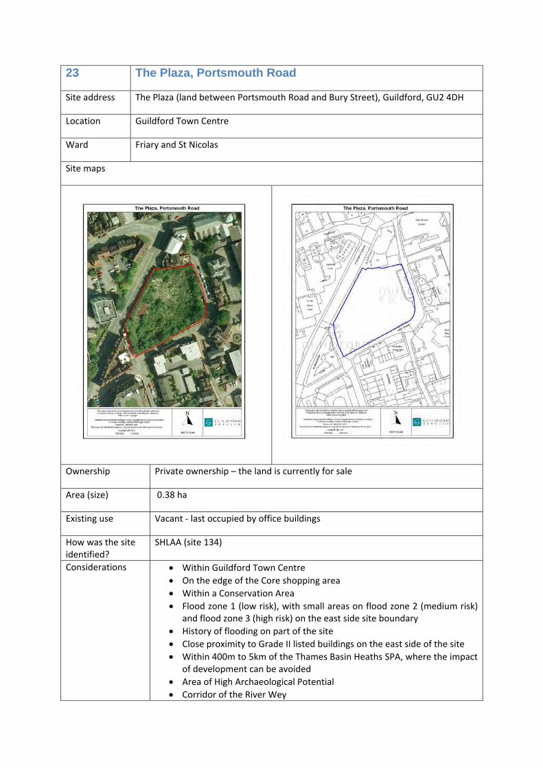
23 The Plaza, Portsmouth Road
Site address The Plaza (land between Portsmouth Road and Bury Street), Guildford, GU2 4DH
Location Guildford Town Centre
Ward Friary and St Nicolas
Site maps
Ownership Private ownership – the land is currently for sale
Area (size) 0.38 ha
Existing use Vacant ‐ last occupied by office buildings
How was the site identified?
SHLAA (site 134)
Considerations • Within Guildford Town Centre • On the edge of the Core shopping area • Within a Conservation Area • Flood zone 1 (low risk), with small areas on flood zone 2 (medium risk)
and flood zone 3 (high risk) on the east side site boundary • History of flooding on part of the site • Close proximity to Grade II listed buildings on the east side of the site • Within 400m to 5km of the Thames Basin Heaths SPA, where the impact
of development can be avoided • Area of High Archaeological Potential • Corridor of the River Wey
• Risk of contamination • Previously developed land
There is a current planning permission for offices (B1a) on this site (ref: 06/P/01430, 10/P/00803).
Allocation Housing (C3)
Timescales 1‐5 years
Opportunities /commentary
This is a previously developed site in Guildford Town Centre close to the railway station and bus station that could deliver new homes (including affordable homes) to help meet the identified need. The development could likely consist of flats, and would need to take account of the close proximity of listed buildings, and potential flood risk. At least 40% of the new homes provided will be affordable homes.
The current planning permission for offices could be implemented before it expires in 2015.
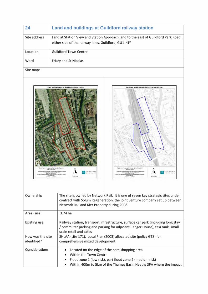
24 Land and buildings at Guildford railway station
Site address Land at Station View and Station Approach, and to the east of Guildford Park Road, either side of the railway lines, Guildford, GU1 4JY
Location Guildford Town Centre
Ward Friary and St Nicolas
Site maps
Ownership The site is owned by Network Rail. It is one of seven key strategic sites under contract with Solum Regeneration, the joint venture company set up between Network Rail and Kier Property during 2008.
Area (size) 3.74 ha
Existing use Railway station, transport infrastructure, surface car park (including long stay / commuter parking and parking for adjacent Ranger House), taxi rank, small scale retail and cafes
How was the site identified?
SHLAA (site 171), Local Plan (2003) allocated site (policy GT8) for comprehensive mixed development
Considerations • Located on the edge of the core shopping area • Within the Town Centre • Flood zone 1 (low risk), part flood zone 2 (medium risk) • Within 400m to 5km of the Thames Basin Heaths SPA where the impact
of development can be avoided • Previously developed land • Risk of contamination • Corridor of the River Wey • Local Plan 2003 Policy M7: Access from Walnut Tree Close to the
Railway Station. Site allocation 122 continues to safeguard land for a route section of a new sustainable movement corridor, providing an attractive, landscaped priority pathway for pedestrians, cyclists and buses. The Guildford Town and Approaches Movement Study Strategy Report (Arup, April 2014) sets out the concept and identifies a potential route.
Allocation Improved transport and interchange facilities to include existing levels of car
parking, Housing (C3) and hotel (C1) and office (B1a) with restaurants and cafes (A3) and/or assembly and leisure (D2) and/or retail (A1)
Timescales 6‐10 years
Opportunities /commentary
This is a very sustainable location for new development. The site can provide a mix of uses, including new homes of which at least 40% will be affordable homes. The primary use will be housing (C3), offices (B1a) and hotel (C1) with some smaller scale uses (A3, D2 and A1).
Site allocation 122 safeguards land for a route section of a new sustainable movement corridor, providing an attractive, landscaped priority pathway for pedestrians, cyclists and buses. The Guildford Town and Approaches Movement Study Strategy Report (Arup, April 2014) sets out the concept and identifies a potential route.
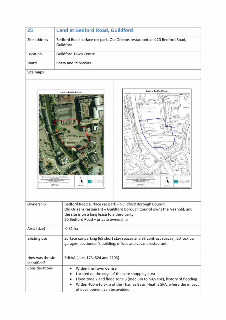
25 Land at Bedford Road, Guildford
Site address Bedford Road surface car park, Old Orleans restaurant and 20 Bedford Road, Guildford
Location Guildford Town Centre
Ward Friary and St Nicolas
Site maps
Ownership Bedford Road surface car park – Guildford Borough Council Old Orleans restaurant – Guildford Borough Council owns the freehold, and the site is on a long lease to a third party 20 Bedford Road – private ownership
Area (size) 0.81 ha
Existing use Surface car parking (68 short stay spaces and 35 contract spaces), 20 lock up garages, auctioneer’s building, offices and vacant restaurant.
How was the site identified?
SHLAA (sites 173, 524 and 2103)
Considerations • Within the Town Centre • Located on the edge of the core shopping area • Flood zone 2 and flood zone 3 (medium to high risk), history of flooding • Within 400m to 5km of the Thames Basin Heaths SPA, where the impact
of development can be avoided
• Conservation area • Previously developed land • Risk of contamination • Corridor of the River Wey • Local Plan (2003) allocated site (policy GT1) for mixed or the following
Allocation Offices (B1a) and/or housing (C3) with restaurants and cafes (A3)
Timescales 6‐10 years
Opportunities /commentary
There is an opportunity for improvements to the riverside and to pedestrian routes between the station and shopping area. A new town plaza environment could be created here, with the benefit of the riverside, cafes, places of work and leisure facilities (cinema).
Residential use would be suitable here apart from on ground floors due to flood risk. At least 40% of any new homes provided will be affordable homes.
This site would also be a prime location for modern offices, as it is exceptionally well located next to the station. Offices here could provide a head quarters premises for a large employer.
26 Bright Hill surface car park and Adult Education Centre
Site address Land between Bright Hill/Harvey Road and Sydenham Road, Guildford, GU1 3RX
Location Guildford Town Centre
Ward Holy Trinity
Site maps
Ownership Guildford Borough Council and Surrey County Council
Area (size) 0.88 ha
Existing use Surface car park (short stay ‐ 121 spaces) and education (D1)
How was the site identified?
SHLAA (site 174 and 88)
Considerations • Within the Town Centre • Located on the edge of the core shopping area • Flood zone 1 (low risk) • Within 400m to 5km of the Thames Basin Heaths SPA, where the
impact of development can be avoided • Conservation area • Area of High Archeological Potential • Previously developed land • Topography ‐ varied levels on the site • Locally listed building (Adult Education Centre) • Local Plan policy H2 Housing Proposal (Bright Hill Car Park)
Allocation Residential (C3) and public car parking
Timescales 11‐15 years
Opportunities /commentary
Combined, these sites provide a potential development opportunity that can provide new homes within the town centre and retain public parking to support this side of the Town Centre. To achieve this, whilst retaining views from this location of the town and cathedral, may require the loss of the locally listed building. This would be considered as part of a potential development proposal. At least 40% of the new homes provided will be affordable homes.
27 Guildford Park Car Park
Site address Land between the railway lines and Guildford Park Avenue, Guildford
Location Guildford Town Centre
Ward Onslow
Site maps
Ownership Guildford Borough Council
Area (size) 1.97 ha
Existing use Surface car park (400 long stay spaces) and garages (118)
How was the site identified?
SHLAA (site 178)
Considerations • Within the Town Centre • Flood zone 1 (low risk) • Within 400m to 5km of the Thames Basin Heaths SPA, where the impact
of development can be avoided • Previously developed land
Allocation Housing (C3) and parking
Timescales 1‐5 years
Opportunities /commentary
There is an opportunity to provide new homes, including many affordable homes (at least 40% of the new homes provided will be affordable homes), in this sustainable location close to the station, whilst continuing to provide public parking.
28 York House, Chertsey Street, Guildford
Site address York House, Chertsey Street, Guildford, GU1 4HD
Location Guildford Town Centre
Ward Holy Trinity
Site maps
Ownership Privately owned
Area (size) 0.06 ha
Existing use Offices (B1a)
How was the site identified?
Part of SHLAA site 525
Considerations • Guildford Town Centre • Flood zone 1 (low risk) • Within 400m to 5km of the Thames Basin Heaths SPA, where the impact
of development can be avoided • Area of High Archaeological Potential • Conservation area • Listed buildings on site (grade II) and the site is close to another listed
building (grade II) across the road • Outside of the core shopping area • Previously developed land
Allocation Housing (C3) and/or offices (B1a)
Timescales 6‐10 years
Opportunities /commentary
It is likely that it would be difficult to re‐let these offices when the current lease expires, and that new homes will be provided here in the future. However, this site could also be redeveloped to provide improved office facilities, or a mix of both uses. At least 40% of new homes provided will be affordable homes.
29 Jewsons, Walnut Tree Close
Site address Jewsons, Walnut Tree Close, Guildford, GU1 4UB
Location Guildford Town Centre
Ward Friary and St Nicolas
Site maps
Ownership Private ownership
Area (size) 0.73 ha
Existing use Buildings merchant (sui generis)
How was the site identified?
SHLAA (site 1107)
Considerations • Guildford Town Centre • Flood zone 1 (low risk) • Within 400m to 5km of the Thames Basin Heaths SPA, where the impact
of development can be avoided • Corridor of the River Wey • Previously developed land • Local Plan 2003 Policy M7: Access from Walnut Tree Close to the
Railway Station. Site allocation 122 continues to safeguard land for a route section of a new sustainable movement corridor, providing an attractive, landscaped priority pathway for pedestrians, cyclists and buses. The Guildford Town and Approaches Movement Study Strategy
Report (Arup, April 2014) sets out the concept and identifies a potential route.
Allocation Housing (C3) and/or office (B1a)
Timescales 6‐10 years
Opportunities /commentary
There is an opportunity to provide new homes, including many affordable homes (at least 40% affordable homes), in this sustainable location close to the station. There is potential to incorporate some commercial office as part of a residential‐led mixed‐use scheme.
Site allocation 122 safeguards land for a route section of a new sustainable movement corridor, providing an attractive, landscaped priority pathway for pedestrians, cyclists and buses. The Guildford Town and Approaches Movement Study Strategy Report (Arup, April 2014) sets out the concept and identifies a potential route.
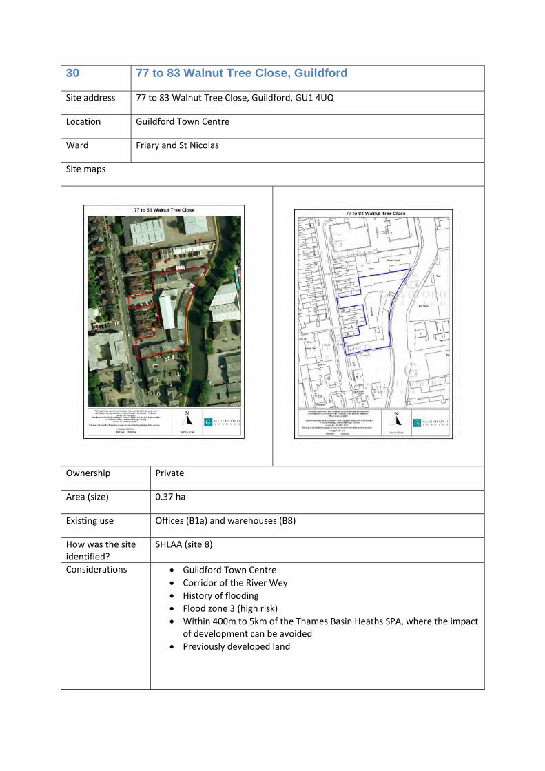
30 77 to 83 Walnut Tree Close, Guildford
Site address 77 to 83 Walnut Tree Close, Guildford, GU1 4UQ
Location Guildford Town Centre
Ward Friary and St Nicolas
Site maps
Ownership Private
Area (size) 0.37 ha
Existing use Offices (B1a) and warehouses (B8)
How was the site identified?
SHLAA (site 8)
Considerations • Guildford Town Centre • Corridor of the River Wey • History of flooding • Flood zone 3 (high risk) • Within 400m to 5km of the Thames Basin Heaths SPA, where the impact
of development can be avoided • Previously developed land
Allocation • Housing (C3) and offices (B1a), or
• Offices (B1a) and storage and distribution (B8), or
• Offices (B1a)
Timescales 6‐10 years
Opportunities /commentary
Walnut Tree Close is an area of likely change over the plan period. Redevelopment here would help to improve the character of this area, however, any proposal must address the risk of flooding, and ensure that development does not increase flood risk and takes all available opportunities to reduce flood risk on site and elsewhere. If new homes are provided, at least 40% will be affordable homes.
31 BT Telephone Exchange, Leapale Road, Guildford
Site address Land between Leapale Lane and Leapale Road, Guildford, GU1 4BD
Location Guildford Town Centre
Ward Friary and St Nicolas
Site maps
Ownership Private
Area (size) 0.6 ha
Existing use Telephone exchange (sui generis)
How was the site identified?
SHLAA (site 230)
Considerations • Guildford Town Centre • Flood zone 1 (low risk) • Within 400m to 5km of the Thames Basin Heaths SPA, where the impact
of development can be avoided • Previously developed land
Allocation Housing (C3) and/or offices (B1a)
Timescales 11‐15 years and beyond
Opportunities /commentary
This is a large potential development site within the town centre that could significantly contribute towards future housing supply, including affordable homes or provide new modern offices. If new homes are provided, at least 40% will be affordable homes.
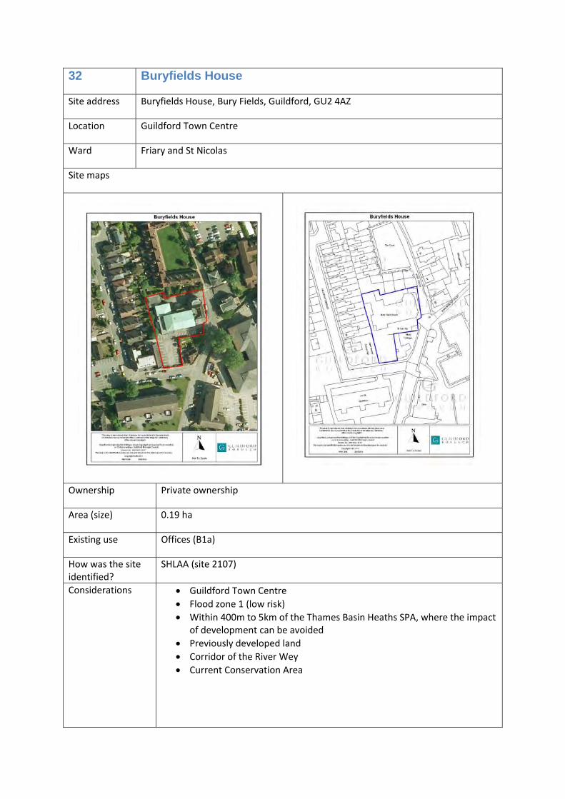
32 Buryfields House
Site address Buryfields House, Bury Fields, Guildford, GU2 4AZ
Location Guildford Town Centre
Ward Friary and St Nicolas
Site maps
Ownership Private ownership
Area (size) 0.19 ha
Existing use Offices (B1a)
How was the site identified?
SHLAA (site 2107)
Considerations • Guildford Town Centre • Flood zone 1 (low risk) • Within 400m to 5km of the Thames Basin Heaths SPA, where the impact
of development can be avoided • Previously developed land • Corridor of the River Wey • Current Conservation Area
Allocation Housing (C3) and/or offices (B1a)
Timescales 1‐5 years
Opportunities /commentary
These premises do not meet current modern office requirements, and are unlikely to be re‐let for this use. This land could be redeveloped in the future to provide new homes, or improved modern offices. If new homes are provided, at least 40% will be affordable homes.
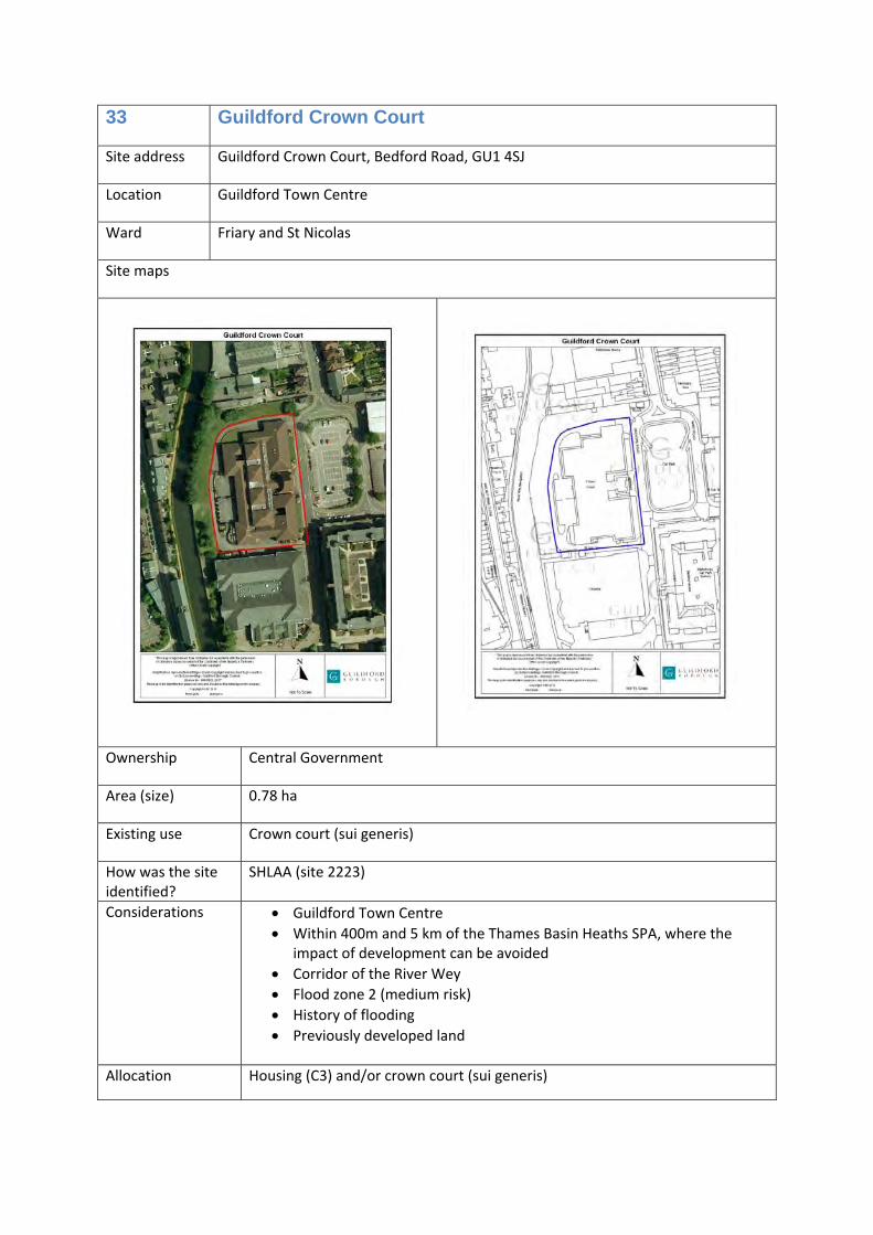
33 Guildford Crown Court
Site address Guildford Crown Court, Bedford Road, GU1 4SJ
Location Guildford Town Centre
Ward Friary and St Nicolas
Site maps
Ownership Central Government
Area (size) 0.78 ha
Existing use Crown court (sui generis)
How was the site identified?
SHLAA (site 2223)
Considerations • Guildford Town Centre • Within 400m and 5 km of the Thames Basin Heaths SPA, where the
impact of development can be avoided • Corridor of the River Wey • Flood zone 2 (medium risk) • History of flooding • Previously developed land
This site is close to the railway station, bus station, shops and facilities, and provides the opportunity to access the Wey Navigation by providing a building that is open to the river, with green landscaped areas. This site could be redeveloped to provide new homes, or improved court facilities if required, or a mix of both uses. If new homes are provided, at least 40% will be affordable homes.
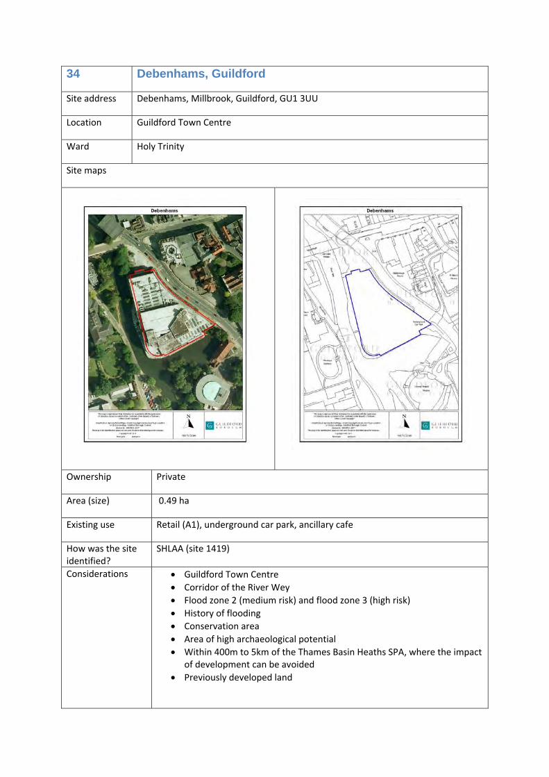
34 Debenhams, Guildford
Site address Debenhams, Millbrook, Guildford, GU1 3UU
Location Guildford Town Centre
Ward Holy Trinity
Site maps
Ownership Private
Area (size) 0.49 ha
Existing use Retail (A1), underground car park, ancillary cafe
How was the site identified?
SHLAA (site 1419)
Considerations • Guildford Town Centre • Corridor of the River Wey • Flood zone 2 (medium risk) and flood zone 3 (high risk) • History of flooding • Conservation area • Area of high archaeological potential • Within 400m to 5km of the Thames Basin Heaths SPA, where the impact
of development can be avoided • Previously developed land
Allocation Housing (C3) and/or retail (A1) and underground parking, with cafes/restaurants (A3) and/or non residential institutions (D1)
Timescales 11‐15 years and beyond
Opportunities /commentary
This is a prominent site in the town centre, next to the river. Redevelopment here could provide many flats and help open up the river to the town. At least 40% of any new homes provided will be affordable homes. Uses at least risk of flooding should be provided on the ground floor.
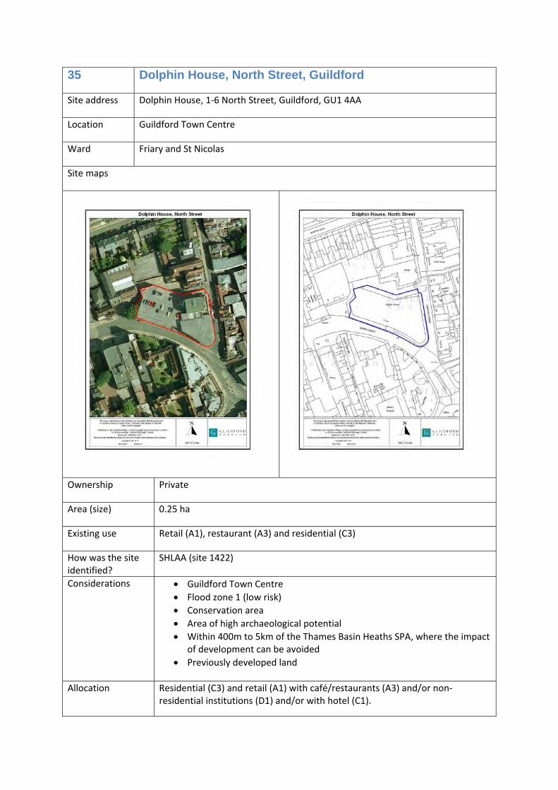
35 Dolphin House, North Street, Guildford
Site address Dolphin House, 1‐6 North Street, Guildford, GU1 4AA
Location Guildford Town Centre
Ward Friary and St Nicolas
Site maps
Ownership Private
Area (size) 0.25 ha
Existing use Retail (A1), restaurant (A3) and residential (C3)
How was the site identified?
SHLAA (site 1422)
Considerations • Guildford Town Centre • Flood zone 1 (low risk) • Conservation area • Area of high archaeological potential • Within 400m to 5km of the Thames Basin Heaths SPA, where the impact
of development can be avoided • Previously developed land
Allocation Residential (C3) and retail (A1) with café/restaurants (A3) and/or non‐
residential institutions (D1) and/or with hotel (C1).
A loss of the current residential use would not be acceptable.
Timescales 11‐15 years and beyond
Opportunities /commentary
This is a prominent town centre site in a key strategic position due to its proximity to North Street and High Street. A mixed use development would be suitable, ensuring there is no loss of the current amount of homes. At least 40% of any new homes provided will be affordable homes.
36 Guildford Borough Council offices, Millmead, Guildford
Site address Council offices, Millmead, Guildford, GU2 4BB
Location Guildford Town Centre
Ward Friary and St Nicolas
Site maps
Ownership Guildford Borough Council
Area (size) 0.97 ha
Existing use Offices (B1a) and car parking
How was the site identified?
SHLAA (site 1420)
Considerations • Guildford Town Centre • Primarily flood zone 1 (low risk), the eastern part of the site is in flood
zone 2 (medium risk) and a very small part of the eastern part of the site is in flood zone 3 (high risk)
• Within 400m to 5km of the Thames Basin Heaths SPA, where the impact of development can be avoided
• Conservation area • Area of High Archaeological Potential • Listed building (Grade II) • Corridor of the River Wey
• Tree preservation orders adjoining the site on western boundary and southeast corner
• Previously developed land Allocation Housing (C3) and/or offices (B1a)
Timescales 11‐15 years and beyond
Opportunities /commentary
This site provides a longer term redevelopment opportunity close to the river, services, shops and the railway station. Any residential development or mixed‐use development would need to have significant regard to flood risk. If new homes are provided, at least 40% will be affordable homes.
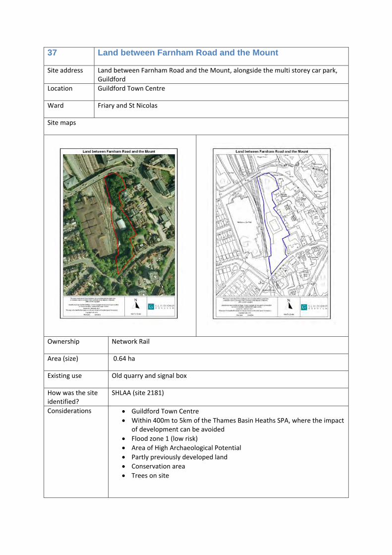
37 Land between Farnham Road and the Mount
Site address Land between Farnham Road and the Mount, alongside the multi storey car park, Guildford
Location Guildford Town Centre
Ward Friary and St Nicolas
Site maps
Ownership Network Rail
Area (size) 0.64 ha
Existing use Old quarry and signal box
How was the site identified?
SHLAA (site 2181)
Considerations • Guildford Town Centre • Within 400m to 5km of the Thames Basin Heaths SPA, where the impact
of development can be avoided • Flood zone 1 (low risk) • Area of High Archaeological Potential • Partly previously developed land • Conservation area • Trees on site
Allocation Housing (C3)
Timescales 6‐10 years
Opportunities /commentary
There are constraints to development that would need to be addressed as part of a development proposal, particularly in reference to any trees on site and the impact of development on the conservation area. This site is a sustainable location for residential development, with close proximity to the railway station, bus station and shops. At least 40‐45% of new homes provided will be affordable homes.
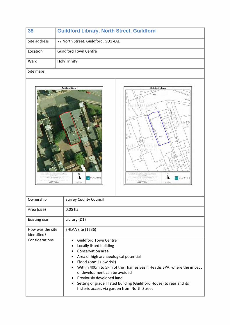
38 Guildford Library, North Street, Guildford
Site address 77 North Street, Guildford, GU1 4AL
Location Guildford Town Centre
Ward Holy Trinity
Site maps
Ownership Surrey County Council
Area (size) 0.05 ha
Existing use Library (D1)
How was the site identified?
SHLAA site (1236)
Considerations • Guildford Town Centre • Locally listed building • Conservation area • Area of high archaeological potential • Flood zone 1 (low risk) • Within 400m to 5km of the Thames Basin Heaths SPA, where the impact
of development can be avoided • Previously developed land • Setting of grade I listed building (Guildford House) to rear and its
This is a well located prominent site that could be redeveloped to provide a mix of uses, should the library be relocated. At least 40% of any new homes provided will be affordable homes.
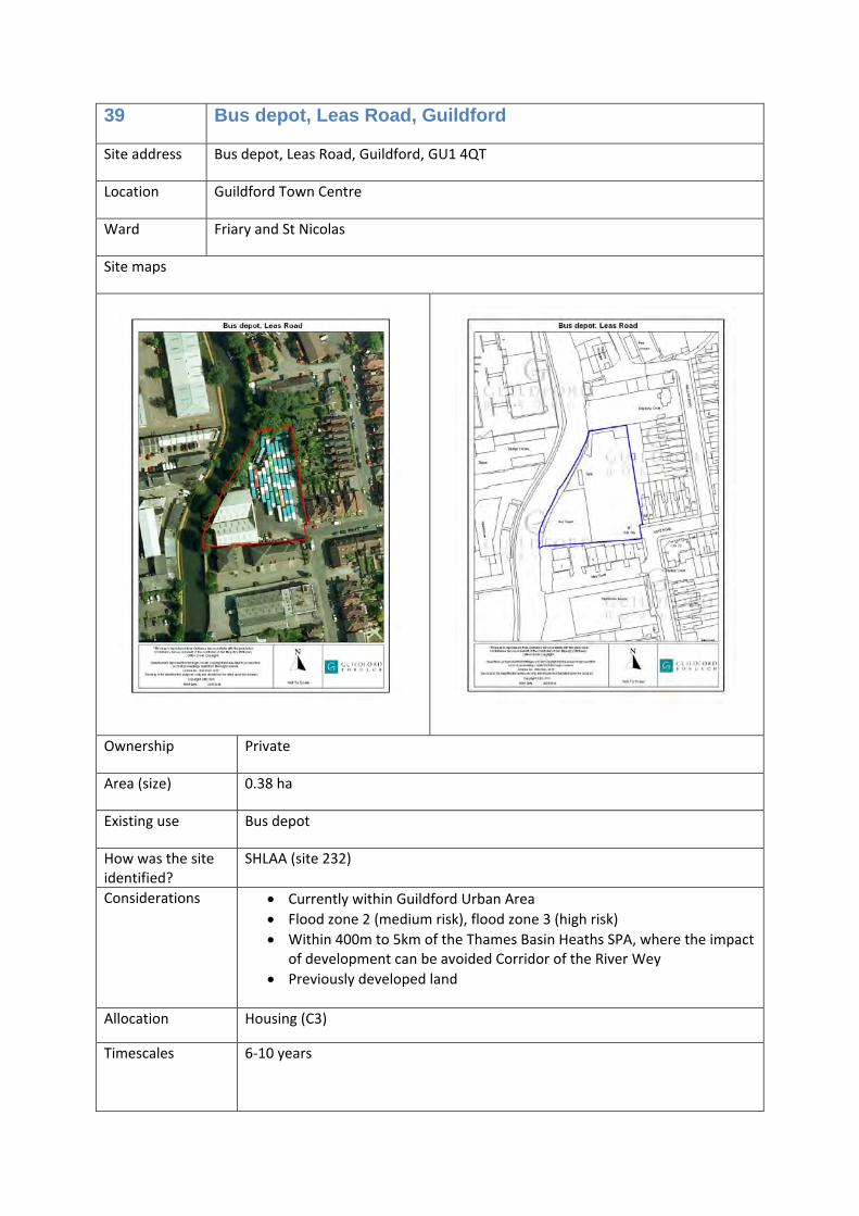
39 Bus depot, Leas Road, Guildford
Site address Bus depot, Leas Road, Guildford, GU1 4QT
Location Guildford Town Centre
Ward Friary and St Nicolas
Site maps
Ownership Private
Area (size) 0.38 ha
Existing use Bus depot
How was the site identified?
SHLAA (site 232)
Considerations • Currently within Guildford Urban Area • Flood zone 2 (medium risk), flood zone 3 (high risk) • Within 400m to 5km of the Thames Basin Heaths SPA, where the impact
of development can be avoided Corridor of the River Wey • Previously developed land
Allocation Housing (C3)
Timescales 6‐10 years
Opportunities /commentary
Any proposed development must take account of flood risk, and ensure that redevelopment does not increase flood risk on site, or elsewhere. The depot will need to be relocated to allow redevelopment of this site. At least 40% of new homes provided will be affordable homes.
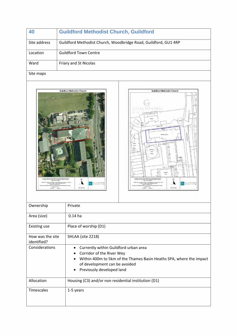
40 Guildford Methodist Church, Guildford
Site address Guildford Methodist Church, Woodbridge Road, Guildford, GU1 4RP
Location Guildford Town Centre
Ward Friary and St Nicolas
Site maps
Ownership Private
Area (size) 0.14 ha
Existing use Place of worship (D1)
How was the site identified?
SHLAA (site 2218)
Considerations • Currently within Guildford urban area • Corridor of the River Wey • Within 400m to 5km of the Thames Basin Heaths SPA, where the impact
of development can be avoided • Previously developed land
Allocation Housing (C3) and/or non residential institution (D1)
Timescales 1‐5 years
Opportunities /commentary
The current use (D1) is no longer required at this location and this site is likely to be redeveloped to provide new homes in the next few years. It would, however, be suitable to redevelop this site for a D1 use (non residential institution), should that be a consideration of the landowner. If new homes are provided, at least 40% will be affordable homes.
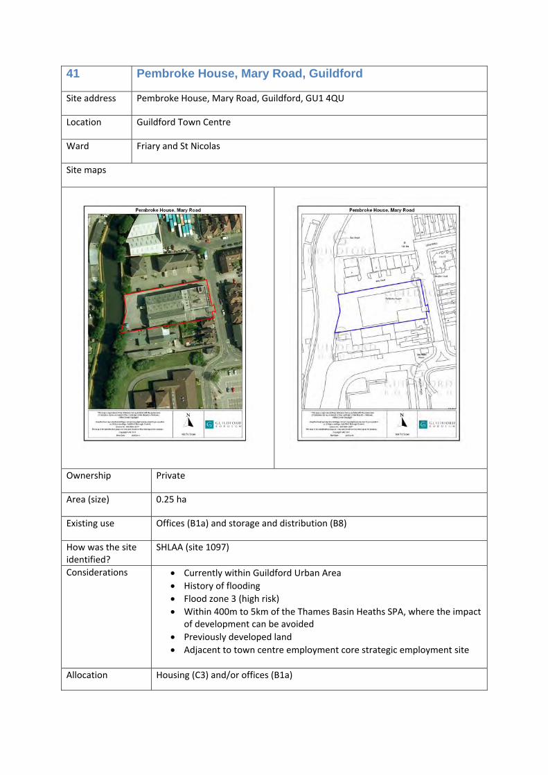
41 Pembroke House, Mary Road, Guildford
Site address Pembroke House, Mary Road, Guildford, GU1 4QU
Location Guildford Town Centre
Ward Friary and St Nicolas
Site maps
Ownership Private
Area (size) 0.25 ha
Existing use Offices (B1a) and storage and distribution (B8)
How was the site identified?
SHLAA (site 1097)
Considerations • Currently within Guildford Urban Area • History of flooding • Flood zone 3 (high risk) • Within 400m to 5km of the Thames Basin Heaths SPA, where the impact
of development can be avoided • Previously developed land • Adjacent to town centre employment core strategic employment site
Allocation Housing (C3) and/or offices (B1a)
Timescales 1‐5 years
Opportunities /commentary
Considerable regard is needed to the risk of flooding. Uses at less risk of flooding should be provided on the ground floor. Only a development proposal that does not increase flood risk and takes all available opportunities to reduce flood risk will be suitable here. If a residential scheme is proposed, new homes on the lowest floor must be safe from flood risk, and it is unlikely that new homes on a ground flood level will be acceptable unless it can be demonstrated that they are not at risk of flooding. If new homes are provided, at least 40% will be affordable homes.
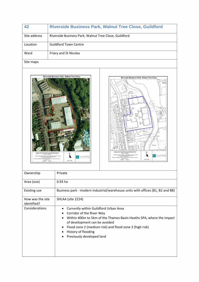
42 Riverside Business Park, Walnut Tree Close, Guildford
Site address Riverside Business Park, Walnut Tree Close, Guildford
Location Guildford Town Centre
Ward Friary and St Nicolas
Site maps
Ownership Private
Area (size) 0.93 ha
Existing use Business park ‐ modern industrial/warehouse units with offices (B1, B2 and B8)
How was the site identified?
SHLAA (site 2224)
Considerations • Currently within Guildford Urban Area • Corridor of the River Wey • Within 400m to 5km of the Thames Basin Heaths SPA, where the impact
of development can be avoided • Flood zone 2 (medium risk) and flood zone 3 (high risk) • History of flooding • Previously developed land
Allocation Housing (C3) and/or office (B1a)
Timescales 6‐10 years
Opportunities /commentary
Walnut Tree Close is an area of likely change over the plan period. Redevelopment here would help to improve the character of this area, however, any proposal must address the risk of flooding, and ensure that development does not increase flood risk and takes all available opportunities to reduce flood risk on site and elsewhere. If new homes are provided, at least 40% will be affordable homes.
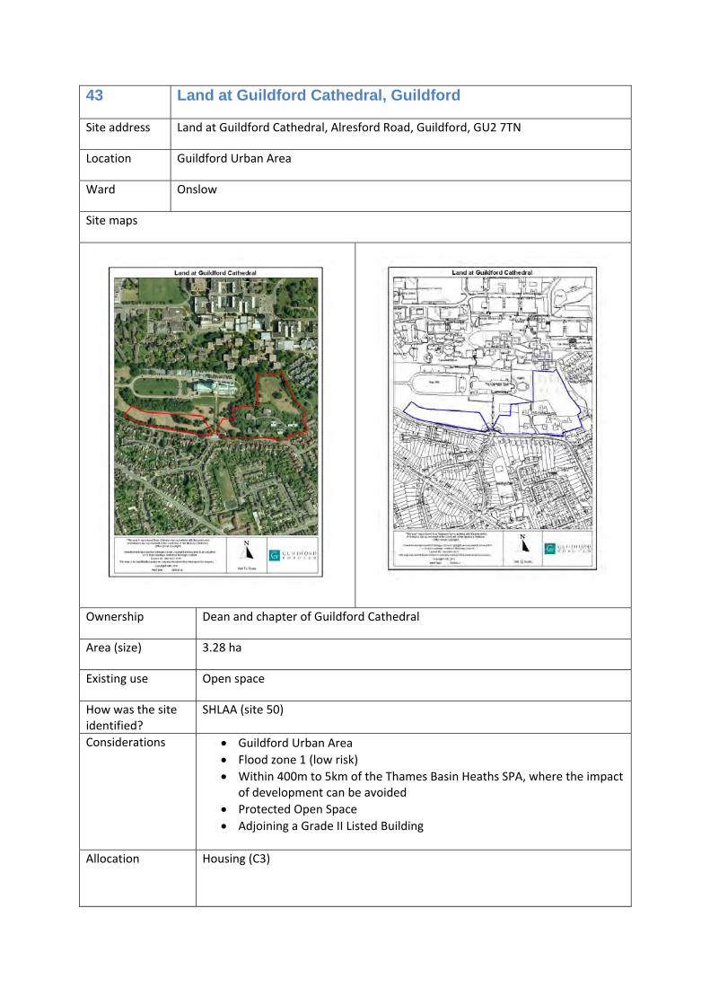
43 Land at Guildford Cathedral, Guildford
Site address Land at Guildford Cathedral, Alresford Road, Guildford, GU2 7TN
Location Guildford Urban Area
Ward Onslow
Site maps
Ownership Dean and chapter of Guildford Cathedral
Area (size) 3.28 ha
Existing use Open space
How was the site identified?
SHLAA (site 50)
Considerations • Guildford Urban Area • Flood zone 1 (low risk) • Within 400m to 5km of the Thames Basin Heaths SPA, where the impact
of development can be avoided • Protected Open Space • Adjoining a Grade II Listed Building
Allocation Housing (C3)
Timescales 1‐5 years
Opportunities /commentary
Redevelopment here will provide new homes (including at least 40‐45% affordable homes) and help support the future of Guildford’s Cathedral. Development of this site will need to be sensitively carried out in view of the settings of a Grade II Listed Building, and consideration of the level of provision of Protected Open Space in the area.
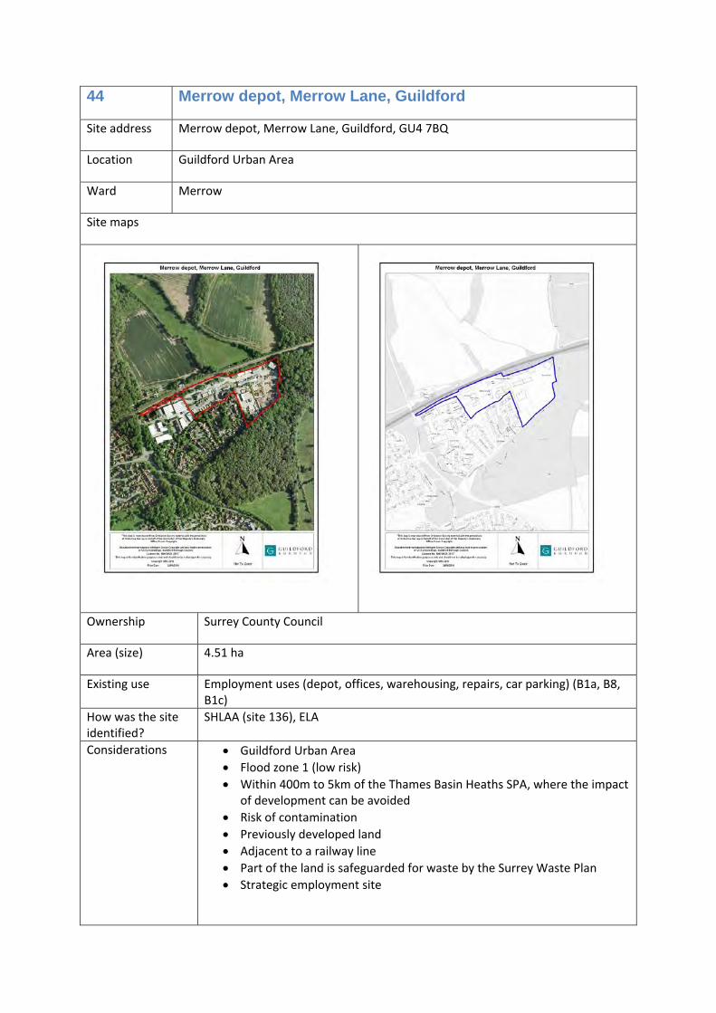
44 Merrow depot, Merrow Lane, Guildford
Site address Merrow depot, Merrow Lane, Guildford, GU4 7BQ
Location Guildford Urban Area
Ward Merrow
Site maps
Ownership Surrey County Council
Area (size) 4.51 ha
Existing use Employment uses (depot, offices, warehousing, repairs, car parking) (B1a, B8, B1c)
How was the site identified?
SHLAA (site 136), ELA
Considerations • Guildford Urban Area • Flood zone 1 (low risk) • Within 400m to 5km of the Thames Basin Heaths SPA, where the impact
of development can be avoided • Risk of contamination • Previously developed land • Adjacent to a railway line • Part of the land is safeguarded for waste by the Surrey Waste Plan • Strategic employment site
Allocation Housing (C3) and/or offices (B1a), or
Light industrial (B1c) and/or storage and distribution (B8)
Timescales 6‐10 years
Opportunities /commentary
Redevelopment of this land will make more efficient use of the land, and provide new homes (including at least 40% affordable homes) with the potential benefit of a new railway station/halt at the adjoining strategic development site (Gosden Hill Farm, north east Guildford).
The site is also suitable for light industrial uses if the access is improved. The number of new homes provided here depends on the type and mix of uses.
Development could facilitate the delivery of a new rail station, possibly partly or wholly on the site, for Merrow on the New Guildford Line.
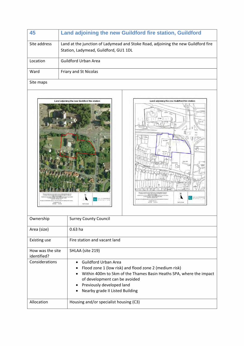
45 Land adjoining the new Guildford fire station, Guildford
Site address Land at the junction of Ladymead and Stoke Road, adjoining the new Guildford fire Station, Ladymead, Guildford, GU1 1DL
Location Guildford Urban Area
Ward Friary and St Nicolas
Site maps
Ownership Surrey County Council
Area (size) 0.63 ha
Existing use Fire station and vacant land
How was the site identified?
SHLAA (site 219)
Considerations • Guildford Urban Area • Flood zone 1 (low risk) and flood zone 2 (medium risk) • Within 400m to 5km of the Thames Basin Heaths SPA, where the impact
of development can be avoided • Previously developed land • Nearby grade II Listed Building
Allocation Housing and/or specialist housing (C3)
Timescales 11‐15 years
Opportunities /commentary
The fire station is relocating to land adjoining this site (ref: 12/P/00801), making this land available for development. Any proposal must give considerable regard to the proximity of the nearby Grade II Listed Building. Redevelopment could provide new homes or elderly care accommodation.
At least 40% of any new homes provided will be affordable homes, including development of off‐campus student accommodation and elderly people’s housing (use Class C3) of at least 20 bedrooms.
46 Former Pond Meadow School, Guildford
Site address Former Pond Meadow School, Pond Meadow, Guildford, GU2 8LG
Location Guildford Urban Area
Ward Westborough
Site maps
Ownership Surrey County Council
Area (size) 0.6 ha
Existing use Vacant school buildings (D1)
How was the site identified?
SHLAA (site 1584)
Considerations • Guildford Urban Area • Flood zone 1 (low risk) • Within 400m to 5km of the Thames Basin Heaths SPA, where the impact
of development can be avoided • Previously developed land • Partially protected open space
non‐residential institution (D1) including community facilities.
Timescales 6‐10 years
Opportunities /commentary
This is a vacant site. Redevelopment here will provide new homes (including at least 40% affordable homes), and could also provide a community facility if required.
47 Guildford College, Stoke Road, Guildford
Site address Guildford College, Stoke Road, Guildford, GU1 1EZ
Location Guildford Urban Area
Ward Christchurch
Site maps
Ownership Guildford College
Area (size) 4.8 ha
Existing use Education (D1) and associated uses
How was the site identified?
Local Plan issues and options consultation
Considerations • Guildford Urban Area • Flood zone 1 (low risk) • Within 400m to 5km of the Thames Basin Heaths SPA, where the impact
of development can be avoided • Previously developed land • Some land is protected open space
Allocation Education (D1) and associated uses
Timescales During the plan period
Opportunities /commentary
There are opportunities to provide an intensified education use on this site, to enable the college to meet its future needs
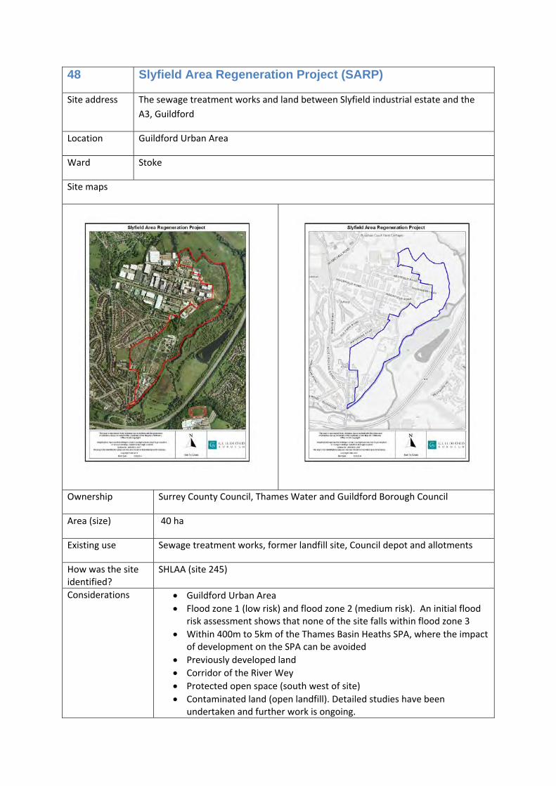
48 Slyfield Area Regeneration Project (SARP)
Site address The sewage treatment works and land between Slyfield industrial estate and the A3, Guildford
Location Guildford Urban Area
Ward Stoke
Site maps
Ownership Surrey County Council, Thames Water and Guildford Borough Council
Area (size) 40 ha
Existing use Sewage treatment works, former landfill site, Council depot and allotments
How was the site identified?
SHLAA (site 245)
Considerations • Guildford Urban Area • Flood zone 1 (low risk) and flood zone 2 (medium risk). An initial flood
risk assessment shows that none of the site falls within flood zone 3 • Within 400m to 5km of the Thames Basin Heaths SPA, where the impact
of development on the SPA can be avoided • Previously developed land • Corridor of the River Wey • Protected open space (south west of site) • Contaminated land (open landfill). Detailed studies have been
undertaken and further work is ongoing.
• Allotments • Community hall • Adjacent to proposed strategic employment site • Infrastructure requirements will include a Clay Lane Link Road, which
could be delivered in two phases, which will connect to the Local Road Network
• Interventions will be required which address the potential highway performance issues which could otherwise result from the development.
Allocation • Housing (C3) and Traveller pitches (sui generis) • Employment ‐ Offices (B1a), Research and development (B1b), Light
industrial (B1c), general industrial (B2), storage and distribution (B8) • A new council waste management depot (relocated on the site) • Waste facilities – the northern area of approximately 11ha is allocated
in Surrey Waste Plan 2008 for non‐thermal waste uses. • A new sewage treatment works (relocated within the site) • Upgraded primary school and financial contributions towards secondary
school expansions • A local retail centre
Timescales 11‐15 years
Opportunities /commentary
This is a strategic development site, providing opportunities for approximately 1,000 new homes and employments uses in the urban area. At least 40% of new homes provided will be affordable homes.
A planning application for phase one of the Clay Lane Link Road is imminent. This will be within the area shown on site allocation 121.
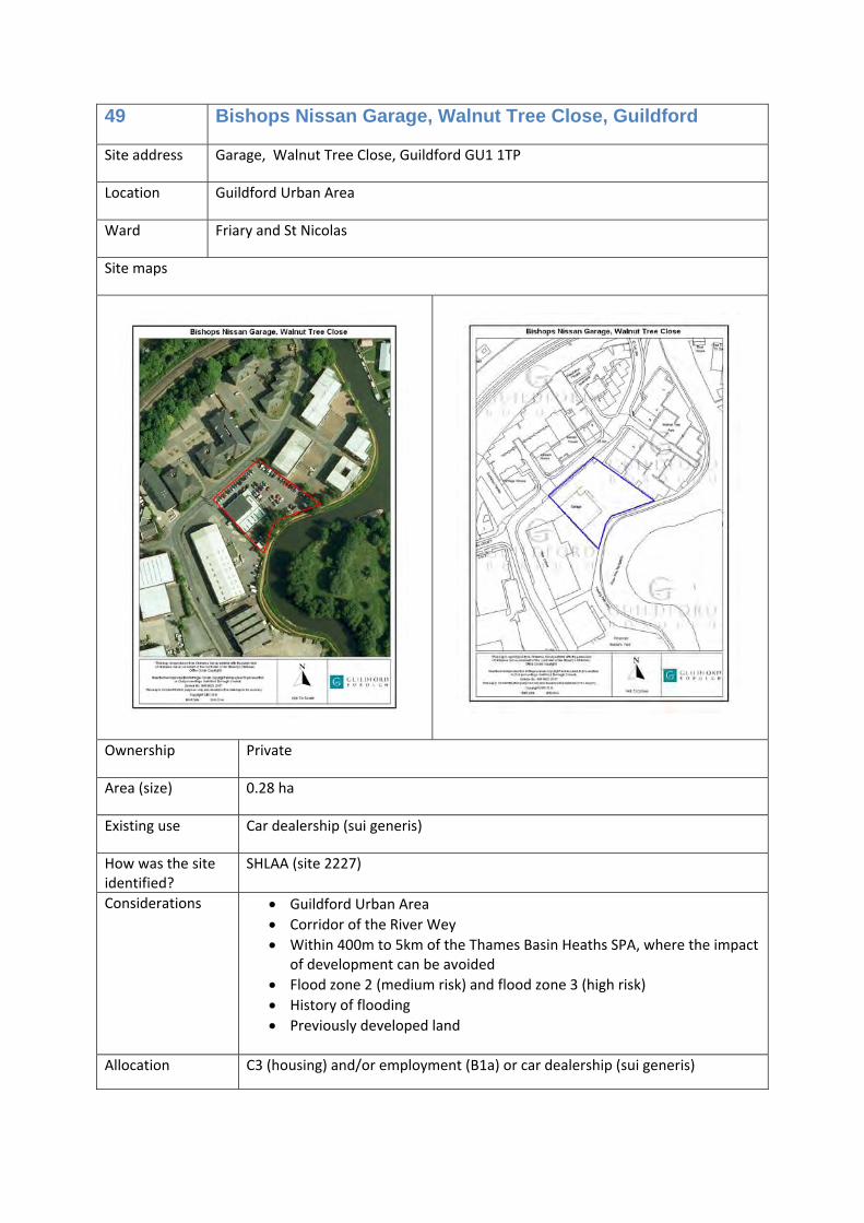
49 Bishops Nissan Garage, Walnut Tree Close, Guildford
Site address Garage, Walnut Tree Close, Guildford GU1 1TP
Location Guildford Urban Area
Ward Friary and St Nicolas
Site maps
Ownership Private
Area (size) 0.28 ha
Existing use Car dealership (sui generis)
How was the site identified?
SHLAA (site 2227)
Considerations • Guildford Urban Area • Corridor of the River Wey • Within 400m to 5km of the Thames Basin Heaths SPA, where the impact
of development can be avoided • Flood zone 2 (medium risk) and flood zone 3 (high risk) • History of flooding • Previously developed land
Allocation C3 (housing) and/or employment (B1a) or car dealership (sui generis)
Timescales 6‐10 years
Opportunities /commentary
Walnut Tree Close is an area of likely change over the plan period. Redevelopment here would help to improve the character of this area, however, any proposal must address the risk of flooding, and ensure that development does not increase flood risk and takes all available opportunities to reduce flood risk on site and elsewhere. If new homes are provided, at least 40% will be affordable homes.
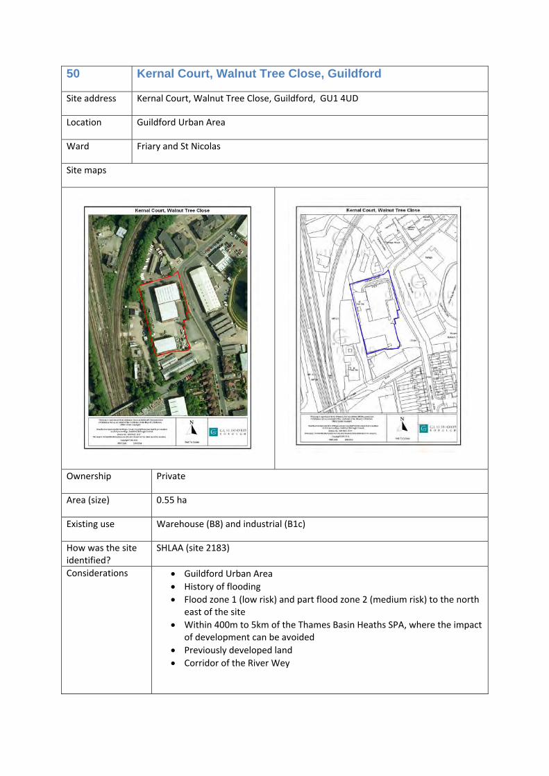
50 Kernal Court, Walnut Tree Close, Guildford
Site address Kernal Court, Walnut Tree Close, Guildford, GU1 4UD
Location Guildford Urban Area
Ward Friary and St Nicolas
Site maps
Ownership Private
Area (size) 0.55 ha
Existing use Warehouse (B8) and industrial (B1c)
How was the site identified?
SHLAA (site 2183)
Considerations • Guildford Urban Area • History of flooding • Flood zone 1 (low risk) and part flood zone 2 (medium risk) to the north
east of the site • Within 400m to 5km of the Thames Basin Heaths SPA, where the impact
of development can be avoided • Previously developed land • Corridor of the River Wey
Walnut Tree Close is an area of likely change over the plan period. Redevelopment here would help to improve the character of this area, however, any proposal must address the risk of flooding, and ensure that development does not increase flood risk and takes all available opportunities to reduce flood risk on site and elsewhere. At least 40% of any new homes provided will be affordable homes.
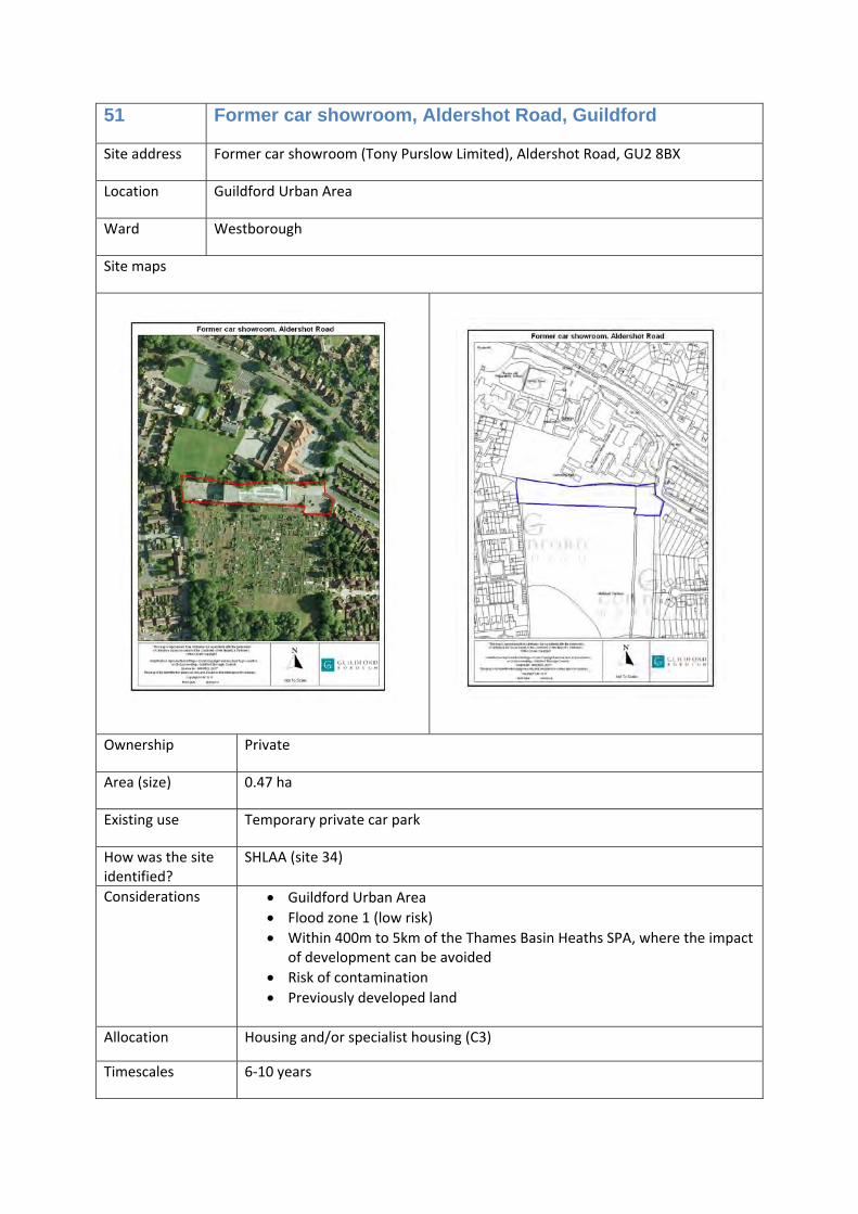
51 Former car showroom, Aldershot Road, Guildford
Site address Former car showroom (Tony Purslow Limited), Aldershot Road, GU2 8BX
Location Guildford Urban Area
Ward Westborough
Site maps
Ownership Private
Area (size) 0.47 ha
Existing use Temporary private car park
How was the site identified?
SHLAA (site 34)
Considerations • Guildford Urban Area • Flood zone 1 (low risk) • Within 400m to 5km of the Thames Basin Heaths SPA, where the impact
of development can be avoided • Risk of contamination • Previously developed land
Allocation Housing and/or specialist housing (C3)
Timescales 6‐10 years
Opportunities /commentary
This is a vacant site that is in a sustainable location for new homes. At least 40% of any new homes provided will be affordable homes.
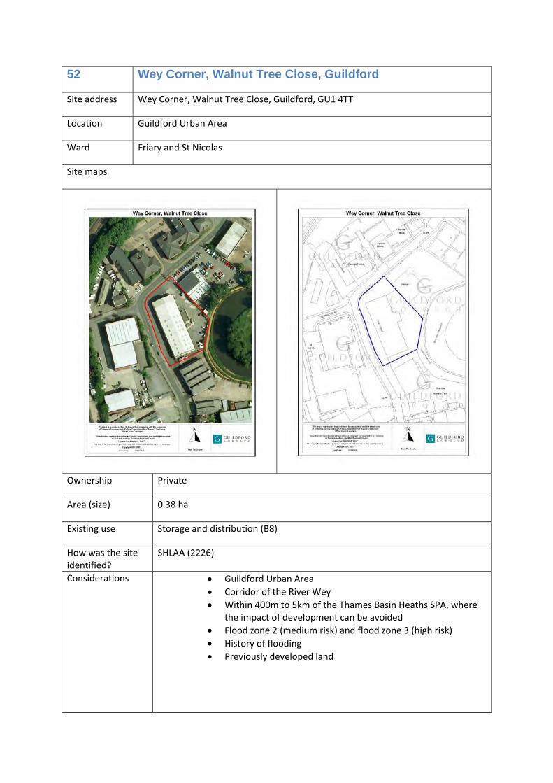
52 Wey Corner, Walnut Tree Close, Guildford
Site address Wey Corner, Walnut Tree Close, Guildford, GU1 4TT
Location Guildford Urban Area
Ward Friary and St Nicolas
Site maps
Ownership Private
Area (size) 0.38 ha
Existing use Storage and distribution (B8)
How was the site identified?
SHLAA (2226)
Considerations • Guildford Urban Area • Corridor of the River Wey • Within 400m to 5km of the Thames Basin Heaths SPA, where
the impact of development can be avoided • Flood zone 2 (medium risk) and flood zone 3 (high risk) • History of flooding • Previously developed land
Allocation Housing (C3) and/or offices (B1a) or storage and distribution (B8)
Timescales 6‐10 years
Opportunities /commentary
Walnut Tree Close is an area of likely change over the plan period. Redevelopment here would help to improve the character of this area, however, any proposal must address the risk of flooding, and ensure that development does not increase flood risk and takes all available opportunities to reduce flood risk on site and elsewhere. If new homes are provided, at least 40% will be affordable homes.
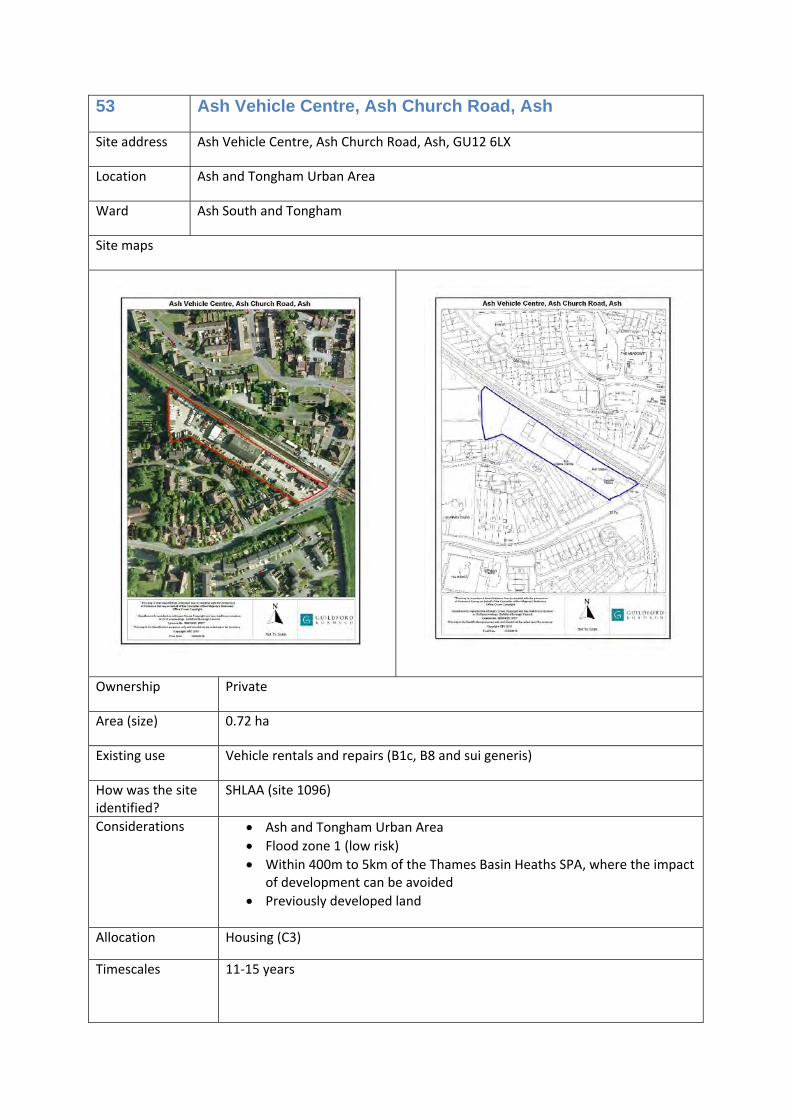
53 Ash Vehicle Centre, Ash Church Road, Ash
Site address Ash Vehicle Centre, Ash Church Road, Ash, GU12 6LX
Location Ash and Tongham Urban Area
Ward Ash South and Tongham
Site maps
Ownership Private
Area (size) 0.72 ha
Existing use Vehicle rentals and repairs (B1c, B8 and sui generis)
How was the site identified?
SHLAA (site 1096)
Considerations • Ash and Tongham Urban Area • Flood zone 1 (low risk) • Within 400m to 5km of the Thames Basin Heaths SPA, where the impact
of development can be avoided • Previously developed land
Allocation Housing (C3)
Timescales 11‐15 years
Opportunities /commentary
This is a highly sustainable location for residential development, close to the railway station, if the current use is no longer required on this site. At least 40% of new homes provided will be affordable homes.
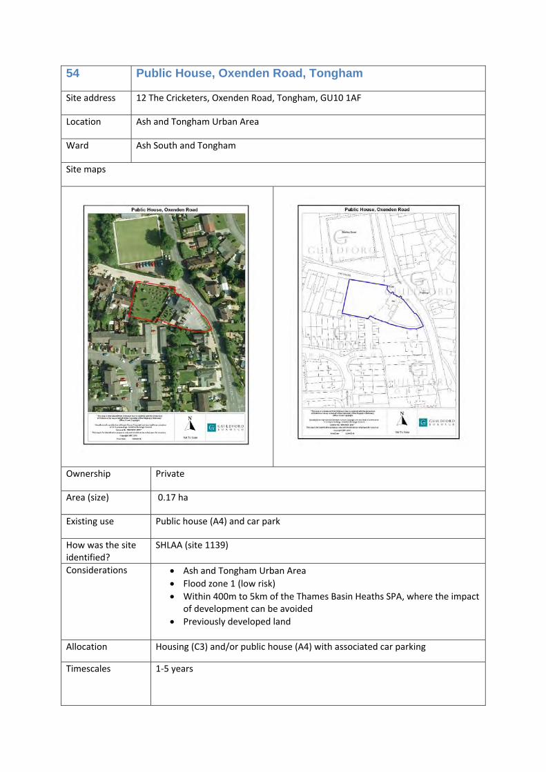
54 Public House, Oxenden Road, Tongham
Site address 12 The Cricketers, Oxenden Road, Tongham, GU10 1AF
Location Ash and Tongham Urban Area
Ward Ash South and Tongham
Site maps
Ownership Private
Area (size) 0.17 ha
Existing use Public house (A4) and car park
How was the site identified?
SHLAA (site 1139)
Considerations • Ash and Tongham Urban Area • Flood zone 1 (low risk) • Within 400m to 5km of the Thames Basin Heaths SPA, where the impact
of development can be avoided • Previously developed land
Allocation Housing (C3) and/or public house (A4) with associated car parking
Timescales 1‐5 years
Opportunities /commentary
National planning policy supports the retention of community facilities such as public houses. This site would be suitable for redevelopment for this use (A4), should that be a viable option. If not, redevelopment to new homes would be appropriate or a mix of both uses. If new homes are provided, at least 40% will be affordable homes.
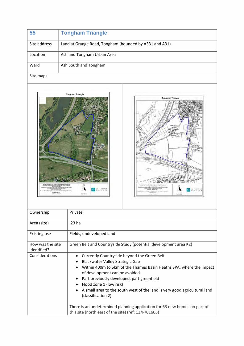
55 Tongham Triangle
Site address Land at Grange Road, Tongham (bounded by A331 and A31)
Location Ash and Tongham Urban Area
Ward Ash South and Tongham
Site maps
Ownership Private
Area (size) 23 ha
Existing use Fields, undeveloped land
How was the site identified?
Green Belt and Countryside Study (potential development area K2)
Considerations • Currently Countryside beyond the Green Belt • Blackwater Valley Strategic Gap • Within 400m to 5km of the Thames Basin Heaths SPA, where the impact
of development can be avoided • Part previously developed, part greenfield • Flood zone 1 (low risk) • A small area to the south west of the land is very good agricultural land
(classification 2) There is an undetermined planning application for 63 new homes on part of this site (north east of the site) (ref: 13/P/01605)
Allocation Employment uses:
Offices (B1a) and/or research and development (B1b) and/or light industrial (B1c) and/or general industrial (B2) and/or storage and distribution (B8)
Timescales 1‐5 years
Opportunities /commentary
This is a well located site for employment uses, with good access to the M3.
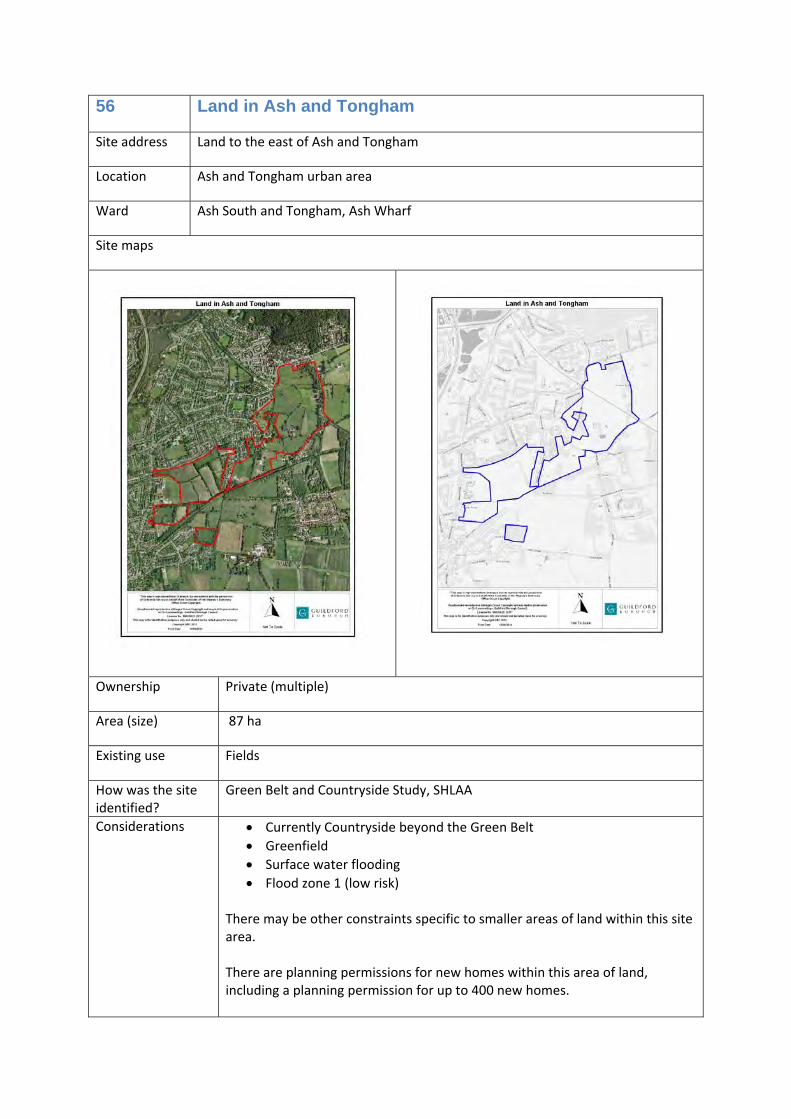
56 Land in Ash and Tongham
Site address Land to the east of Ash and Tongham
Location Ash and Tongham urban area
Ward Ash South and Tongham, Ash Wharf
Site maps
Ownership Private (multiple)
Area (size) 87 ha
Existing use Fields
How was the site identified?
Green Belt and Countryside Study, SHLAA
Considerations • Currently Countryside beyond the Green Belt • Greenfield • Surface water flooding • Flood zone 1 (low risk)
There may be other constraints specific to smaller areas of land within this site area. There are planning permissions for new homes within this area of land, including a planning permission for up to 400 new homes.
Allocation Housing (C3)
Timescales 1‐5 and 6‐10 years
Opportunities /commentary
Whilst this area of land is within multiple land ownership, and may come forward for development at different times within the plan period, we expect significant regard to be had to the impact of development on the existing character of the area, and the infrastructure needs. New homes could be provided in this area (of which 45% will be affordable homes*).
*The planning permission granted for up to 400 new homes in this area will contribute 40% affordable housing.
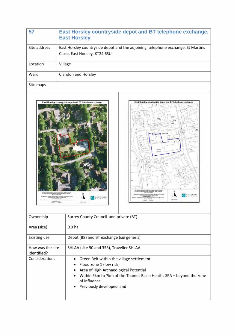
57 East Horsley countryside depot and BT telephone exchange, East Horsley
Site address East Horsley countryside depot and the adjoining telephone exchange, St Martins Close, East Horsley, KT24 6SU
Location Village
Ward Clandon and Horsley
Site maps
Ownership Surrey County Council and private (BT)
Area (size) 0.3 ha
Existing use Depot (B8) and BT exchange (sui generis)
How was the site identified?
SHLAA (site 90 and 353), Traveller SHLAA
Considerations • Green Belt within the village settlement • Flood zone 1 (low risk) • Area of High Archaeological Potential • Within 5km to 7km of the Thames Basin Heaths SPA – beyond the zone
of influence • Previously developed land
Allocation Housing (C3) or
Housing (C3) and Traveller pitch (sui generis)
Timescales 11‐15 years
Opportunities /commentary
If this land becomes available for development, there is the opportunity to provide new homes (of which 40% will be affordable homes). There is also the possibility of providing one Traveller pitch on the land currently used as a depot, as part of mixed sustainable communities.
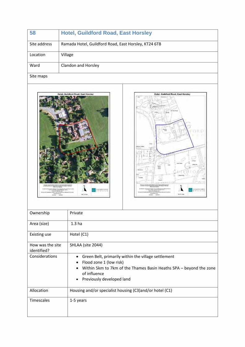
58 Hotel, Guildford Road, East Horsley
Site address Ramada Hotel, Guildford Road, East Horsley, KT24 6TB
Location Village
Ward Clandon and Horsley
Site maps
Ownership Private
Area (size) 1.3 ha
Existing use Hotel (C1)
How was the site identified?
SHLAA (site 2044)
Considerations • Green Belt, primarily within the village settlement • Flood zone 1 (low risk) • Within 5km to 7km of the Thames Basin Heaths SPA – beyond the zone
of influence • Previously developed land
Allocation Housing and/or specialist housing (C3)and/or hotel (C1)
Timescales 1‐5 years
Opportunities /commentary
This is a suitable site for redevelopment for residential uses. At least 40% of any new homes provided will be affordable homes. This site could also be redeveloped to provide new hotel facilities.
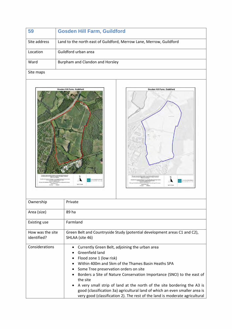
59 Gosden Hill Farm, Guildford
Site address Land to the north east of Guildford, Merrow Lane, Merrow, Guildford
Location Guildford urban area
Ward Burpham and Clandon and Horsley
Site maps
Ownership Private
Area (size) 89 ha
Existing use Farmland
How was the site identified?
Green Belt and Countryside Study (potential development areas C1 and C2), SHLAA (site 46)
Considerations • Currently Green Belt, adjoining the urban area • Greenfield land • Flood zone 1 (low risk) • Within 400m and 5km of the Thames Basin Heaths SPA • Some Tree preservation orders on site • Borders a Site of Nature Conservation Importance (SNCI) to the east of
the site • A very small strip of land at the north of the site bordering the A3 is
good (classification 3a) agricultural land of which an even smaller area is very good (classification 2). The rest of the land is moderate agricultural
land (grade 3b). • Part of site a strategic employment site • Infrastructure requirements could include a relocated A3 southbound
off‐slip, a new A3 southbound on‐slip and connections to the Local Road Network.
• Interventions will be required which address the potential highway performance issues which could otherwise result from the development. The Infrastructure Delivery Schedule identifies the locations on the Local Highway Network and the Strategic Highway Network which could be expected to experience the most significant potential highway performance issues, in the absence of mitigating interventions, from development of this site.
• Other supporting infrastructure must be provided on the site, including – a new two‐form entry primary school, local retail centre, GPs surgery, community building, open space including playgrounds, playing fields and allotments, Suitable Alternative Natural Green Space (SANG), a new Park and Ride facility, a new rail station possibly partly on the site for Merrow on the New Guildford Line.
• Reducing surface water flood risk, potentially with balancing pond(s), on‐site Sustainable Urban Drainage System (SUDs)
• Appropriate assessment required at project level to consider impact on the Thames Basin Heath Special Protection Area (SPA).
B1c), Park and Ride, railway station, open space, education, local retail centre (A1, A2 and A3), community and health services buildings (D1).
Timescales 1‐5, 6‐10 and 11‐15 years
Opportunities /commentary
This is a strategic development site that can accommodate a mix of uses, primarily residential (up to 2000 homes, including at least 45% affordable homes, and eight Traveller pitches), creating a mixed sustainable community.
Part of this site has been designated as a strategic employment site and is expected to deliver a significant amount of employment uses.
Development could facilitate the delivery of a new Park and Ride facility on the site and a new rail station, possibly partly or wholly on the site, for Merrow on the New Guildford Line.
60 Blackwell Farm, Guildford
Site address Land to the south west of Guildford, Blackwell Farm, Hogs Back, Guildford
Location Guildford Urban Area
Ward Shalford, Worplesdon and Onslow
Site maps
Ownership Private
Area (size) 106.2 ha
Existing use Farmland
How was the site identified?
Green Belt and Countryside Study (potential development areas H1 and H2), SHLAA (part of site 311)
Considerations • Currently Green Belt, partially adjoining the urban area • Greenfield land • Flood zone 1 (low risk) • Within 400m and 5km of the Thames Basin Heaths SPA • Partially in an Area of Outstanding Natural Beauty and Area of Great
Landscape Value • The land is primarily moderate (classification 3b) agricultural land, with
an area towards the centre of good agricultural land (classification 3a), and a very small area of very good agricultural land (classification 2) on the western side.
• Part of site strategic employment site • Infrastructure requirements could include a new junction with the A31
Hog’s Back and/or A3 trunk road and connections to the Local Road Network.
• Interventions will be required which address the potential highway performance issues which could otherwise result from the development. The Infrastructure Delivery Schedule identifies the locations on the Local Highway Network and the Strategic Highway Network which could be expected to experience the most significant potential highway performance issues, in the absence of mitigating interventions, from development of this site.
• Developer contributions could also be sought in respect of providing a new Park and Ride facility on the site and a new Park Barn/Surrey Research Park/Blackwell Farm rail station on the North Downs Line.
• Other supporting infrastructure must be provided on the site, including – a new two‐form entry primary school, local retail centre, GPs surgery, open space including playing fields and allotments, Suitable Alternative Natural Green Space (SANG).
• Appropriate assessment required at project level to consider impact on the Thames Basin Heath Special Protection Area (SPA).
generis), open space, Park and Ride, railway station, education, local retail centre (A1, A2 and A3), community and health services buildings (D1).
Timescales 1‐5, 6‐10 and 11‐15 years
Opportunities /commentary
This is a strategic development site that can accommodate a mix of uses, primarily residential (up to 2250 homes, including at least 45% affordable homes, and eight Traveller pitches), creating a mixed sustainable community.
Part of this site has been designated as a strategic employment site and is expected to deliver a significant amount of employment uses.
Development could facilitate the delivery of a new Park and Ride facility on the site and a new rail station, possibly partly or wholly on the site, for Park Barn/Surrey Research Park/Blackwell Farm on the North Downs Line.
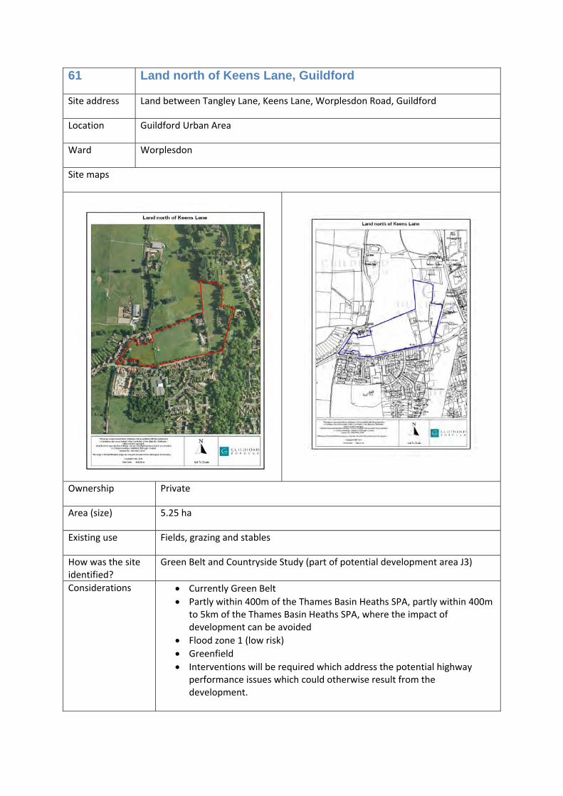
61 Land north of Keens Lane, Guildford
Site address Land between Tangley Lane, Keens Lane, Worplesdon Road, Guildford
Location Guildford Urban Area
Ward Worplesdon
Site maps
Ownership Private
Area (size) 5.25 ha
Existing use Fields, grazing and stables
How was the site identified?
Green Belt and Countryside Study (part of potential development area J3)
Considerations • Currently Green Belt • Partly within 400m of the Thames Basin Heaths SPA, partly within 400m
to 5km of the Thames Basin Heaths SPA, where the impact of development can be avoided
• Flood zone 1 (low risk) • Greenfield • Interventions will be required which address the potential highway
performance issues which could otherwise result from the development.
Allocation Housing (C3) and care home (C2)
Timescales 1‐5 years
Opportunities /commentary
This site could provide new homes (of which at least 45% will be affordable housing) and a care home (approximately 50 beds). The care home would be located in the area of the site within 400 metres of the Thames Basin Heath SPA.
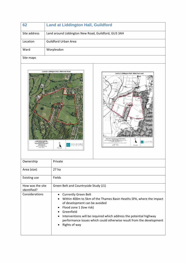
62 Land at Liddington Hall, Guildford
Site address Land around Liddington New Road, Guildford, GU3 3AH
Location Guildford Urban Area
Ward Worplesdon
Site maps
Ownership Private
Area (size) 27 ha
Existing use Fields
How was the site identified?
Green Belt and Countryside Study (J1)
Considerations • Currently Green Belt • Within 400m to 5km of the Thames Basin Heaths SPA, where the impact
of development can be avoided • Flood zone 1 (low risk) • Greenfield • Interventions will be required which address the potential highway
performance issues which could otherwise result from the development • Rights of way
Allocation Housing (C3) and Traveller pitches (sui generis)
Timescales 1‐5 years
Opportunities /commentary
This site can provide new homes, including at least 45% affordable housing, and two Traveller pitches.
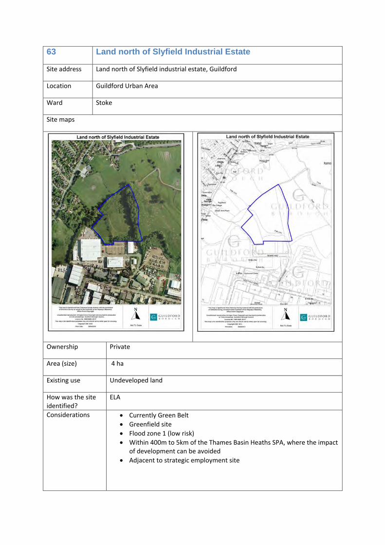
63 Land north of Slyfield Industrial Estate
Site address Land north of Slyfield industrial estate, Guildford
Location Guildford Urban Area
Ward Stoke
Site maps
Ownership Private
Area (size) 4 ha
Existing use Undeveloped land
How was the site identified?
ELA
Considerations • Currently Green Belt • Greenfield site • Flood zone 1 (low risk) • Within 400m to 5km of the Thames Basin Heaths SPA, where the impact
of development can be avoided • Adjacent to strategic employment site
Allocation Employment uses: Light industrial (B1c) and/or general industrial (B2) and/or storage and distribution (B8)
Timescales 1‐5 years
Opportunities /commentary
The site will become part of the Slyfield Industrial Estate and as such will be part of the strategic employment site.
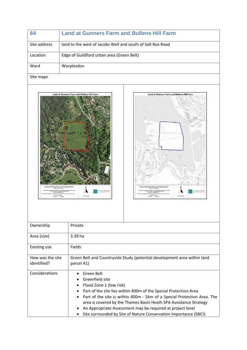
64 Land at Gunners Farm and Bullens Hill Farm
Site address land to the west of Jacobs Well and south of Salt Box Road
Location Edge of Guildford urban area (Green Belt)
Ward Worplesdon
Site maps
Ownership Private
Area (size) 3.39 ha
Existing use Fields
How was the site identified?
Green Belt and Countryside Study (potential development area within land parcel A1)
Considerations • Green Belt • Greenfield site • Flood Zone 1 (low risk) • Part of the site lies within 400m of the Special Protection Area • Part of the site is within 400m ‐ 5km of a Special Protection Area. The
area is covered by the Thames Basin Heath SPA Avoidance Strategy • An Appropriate Assessment may be required at project level • Site surrounded by Site of Nature Conservation Importance (SNCI)
Allocation Community football ground (D2)
Timescales 1‐5 years
Opportunities /commentary
Guildford City FC and Worplesdon Rangers FC are looking for a suitable site for a new ground. Main games pitch with all‐weather and grass practice pitches, clubhouse, floodlighting and training facilities.
65 Land north of Salt Box Road, Guildford
Site address Land north of Salt Box Road, west of the railway line, Guildford
Location Guildford Urban Area
Ward Worplesdon
Site maps
Ownership Private
Area (size) 7.88 ha
Existing use Field
How was the site identified?
Green Belt and Countryside Study (potential development area A4)
Considerations • Currently Green Belt • Greenfield site • Flood zone 1 (low risk) • Within 400m of the Thames Basin Heaths SPA • An Appropriate Assessment may be required at project level • Site almost surrounded by Site of Special Scientific Interest (SSSI)
Allocation Education (D1) – secondary school of at least five forms of entry
Timescales 6‐11 years and 11‐15 years
Opportunities /commentary
Potential for new secondary school to serve increased need in the western part of the borough
Potential access to the site from where Grange Road meets Salt Box Road, with a possible new junction.
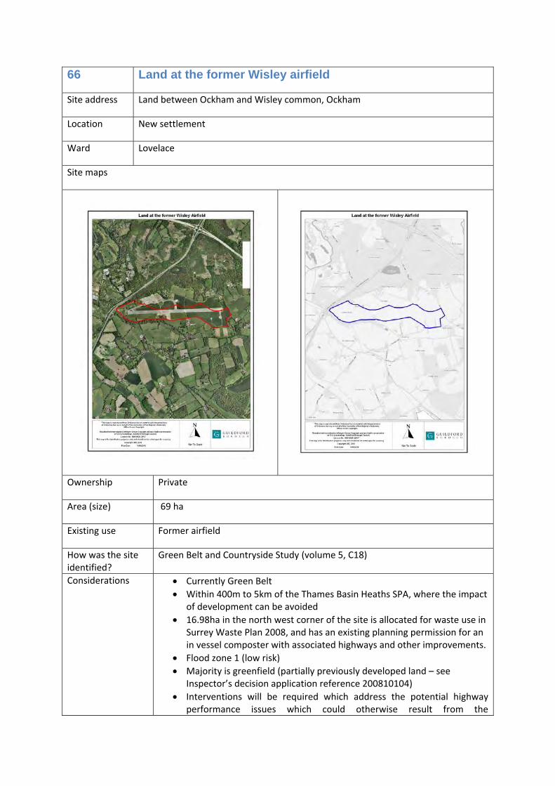
66 Land at the former Wisley airfield
Site address Land between Ockham and Wisley common, Ockham
Location New settlement
Ward Lovelace
Site maps
Ownership Private
Area (size) 69 ha
Existing use Former airfield
How was the site identified?
Green Belt and Countryside Study (volume 5, C18)
Considerations • Currently Green Belt • Within 400m to 5km of the Thames Basin Heaths SPA, where the impact
of development can be avoided • 16.98ha in the north west corner of the site is allocated for waste use in
Surrey Waste Plan 2008, and has an existing planning permission for an in vessel composter with associated highways and other improvements.
• Flood zone 1 (low risk) • Majority is greenfield (partially previously developed land – see
Inspector’s decision application reference 200810104) • Interventions will be required which address the potential highway
performance issues which could otherwise result from the
development. The Infrastructure Delivery Schedule identifies the locations on the Local Highway Network and the Strategic Highway Network which could be expected to experience the most significant potential highway performance issues, in the absence of mitigating interventions, from development of this site.
• Other supporting infrastructure must be provided on the site, including – a new two‐form entry primary school, local retail centre, community, and faith building, healthcare building incorporating a GPs surgery, leisure and recreation facilities, local retail centre, open space including playgrounds, playing fields and allotments, Suitable Alternative Natural Green Space (SANG), high speed Broadband upgrades, drainage and any flood mitigation measures needed.
• Appropriate assessment required at project level to consider impact on the Thames Basin Heath Special Protection Area (SPA) and Environmental Impact Assessment to consider impact on the Site of Nature Conservation Interest.
Allocation Housing (C3), Traveller pitches (sui generis), Employment use (as a designated
strategic employment site) ‐ Offices (B1a), Research and development (B1b), Light industrial (B1c), general industrial (B2), storage and distribution (B8), education, community and health services buildings (D1), open space. 16.98ha in the north west corner of the site is allocated for waste use in Surrey Waste Plan 2008
Timescales 1‐5, 6‐10 and 11‐15 years
Opportunities /commentary
This is a strategic development site that can accommodate a mix of uses, primarily residential (up to 2,100 homes, including at least 40‐45% affordable homes, and eight Traveller pitches), creating a mixed sustainable community.
Part of the site will be designated as a strategic employment site and is expected to deliver a significant amount of employment use.
67 Tannery House, Cheriton, and land adjacent, Tannery Lane, Send
Site address Tannery House, Cheriton, and land adjacent, Tannery Lane, Send
Location Village
Ward Send
Site maps
Ownership Private
Area (size) 1.4 ha
Existing use Undeveloped land
How was the site identified?
ELA
Considerations • Currently Green Belt • Greenfield site • Flood zone 1 (low risk) • Within 400m to 5km of the Thames Basin Heaths SPA, where the impact
of development can be avoided
Allocation Employment uses: Offices (B1a) and/or research and development (B1b) and/or light industrial (B1c)
Timescales 1‐5 years
Opportunities /commentary
Send Business Centre provides start‐up and innovative business floor space as well as more established companies. The site is focussing on the digital sector with a view to creating a hub to meet the demand for activities such as studios, video, sound and post production. Local Enterprise Partnership funding is in place to improve fibre infrastructure and promote innovation support.
68 Land at Hornhatch Farm, Chilworth
Site address Land to the west of Chilworth, adjoining New Road, Chilworth
Location Village
Ward Shalford
Site maps
Ownership Private
Area (size) 5 ha
Existing use Fields
How was the site identified?
Green Belt and Countryside Study (potential development area E51‐B), SHLAA (site 2032)
Considerations • Currently Green Belt, adjoining the village • Greenfield • Flood zone 1 (low risk) • Within 5km to 7km of the Thames Basin Heaths SPA – beyond the zone
of influence • Grade 3 (moderate/good) agricultural land
Allocation Housing (C3)
Timescales 1‐5 years
Opportunities /commentary
The site is within single ownership. This site could deliver new homes, including at least 45% affordable homes. The site is outside of the zone of influence regarding the Thames Basin Heaths SPA and therefore does not need to provide Suitable Alternative Natural Green space or financial contributions in accordance with the Thames Basin Heaths SPA Avoidance Strategy.
69 Redevelopment of Howard of Effingham School and associated land, Effingham
Site address Land at Effingham Village including the Howard of Effingham School, the field to the east of The Street, and Effingham Lodge Farm and associated land (located to the north of Lower Road), Effingham, KT24 5JR
Location Village
Ward Effingham
Site maps
Ownership Berkeley Homes and Howard of Effingham School
Area (size) 17 ha
Existing use Education (D1), greenfield and a previous nursery
How was the site identified?
Green Belt and Countryside Study (potential development areas D10)
Considerations • Currently Green Belt • Within 5km to 7km of the Thames Basin Heaths SPA – beyond the zone
of influence • Partly previously developed land, partly Greenfield • Flood zone 1 (low risk) • Part conservation area
Allocation Education (D1) and housing (C3)
Timescales 1‐5 years
Opportunities /commentary
There is an opportunity for new homes to enable provision of an improved secondary school. This includes at least 45% affordable homes.
70 Land to the north of West Horsley
Site address Land at Green Lane and Ockham Road North, West Horsley
Location Village
Ward Clandon and Horsley
Site maps
Ownership Private
Area (size) 8 ha
Existing use Fields and residential
How was the site identified?
Green Belt and Countryside Study (potential development area C14‐A), volume 4 of the Green Belt and Countryside Study, SHLAA (sites 975, 2027 and 13)
Considerations • Currently Green Belt, adjoining the village • Greenfield • Primarily flood zone 1 (low risk), however land to the north east of the
land parcel is within flood zone 2 and 3 (medium and high risk) Development proposals would be subject to a Flood Risk Assessment
• Within 400m‐5km of the Thames Basin Heaths SPA • A small area of the land to the west is poor agricultural land
(classification 4). The other area is not classified
Allocation Housing (C3)
Timescales 1‐5 years
Opportunities /commentary
This site could provide new homes, including at least 45% affordable homes. There is likely to be Suitable Alternative Natural Green space (SANG) available in this area. The land is primarily owned by a developer.
71 Land to the west of West Horsley
Site address Land between East Lane and Long Reach, West Horsley
Location Village
Ward Clandon and Horsley
Site maps
Ownership Private
Area (size) 8.4 ha
Existing use Fields, residential and children’s nursery
How was the site identified?
Green Belt and Countryside Study (potential development area C14‐C), SHLAA (site285, 15 and part of site 155)
Considerations • Currently Green Belt, adjoining the village • Greenfield land • Flood zone 1 • Within 400m and 5km of the Thames Basin Heaths SPA • Manor Farm House is a listed building (grade II) • Primarily moderate or good agricultural land (classification 3) with
some poor agricultural land to the north west (classification 4)
Allocation Housing (C3)
Timescales 1‐5 years
Opportunities /commentary
This site could provide new homes including at least 40‐45% affordable homes. There is Suitable Alternative Natural Green space (SANG) available to the north of this land. The majority of this land is under option to a developer.
72 Land near Horsley Railway Station, Ockham Road North, West Horsley
Site address Land to the west of Horsley Railway Station, north of the railway line and west of Ockham Road North, West Horsley
Location Village
Ward Clandon and Horsley
Site maps
Ownership Private
Area (size) 5.1 ha
Existing use Fields
How was the site identified?
SHLAA (site 240)
Considerations • Currently Green Belt, adjoining the village • Greenfield • Flood zone 1 (low risk), part flood zones 2 and 3 (medium and high risk) • Within 400m and 5km of the Thames Basin Heaths SPA
Allocation Housing (C3)
Timescales 1‐5 years
Opportunities /commentary
The site was not included as a potential development area in the Green Belt and Countryside Study due to uncertainties about access. The owner has secured access to the site with options on some properties. This is a well‐contained site exceptionally close to the railway station. Suitable Alternative Natural Green Space is likely to be available in the local area. A flood risk assessment would be required to ensure that development does not increase flood risk on site or else where. This site could provide new homes, including at least 45% affordable homes.
73 Land to the west of West Horsley (south)
Site address Land to the west of Silkmore Lane and east of Ripley Lane, West Horsley
Location Village
Ward Clandon and Horsley
Site maps
Ownership Private
Area (size) 9.8 ha
Existing use Fields
How was the site identified?
Green Belt and Countryside Study (potential development area D6‐C), SHLAA (sites part of 139, 714, 2026 and 1037)
Considerations • Currently Green Belt, adjoining the village • Greenfield land • Flood zone 1 (low risk) • Within 400m to 5km of the Thames Basin Heaths SPA • Grade 3 (moderate/good) agricultural land
Allocation Housing (C3)
Timescales 1‐5 years
Opportunities /commentary
This site could provide new homes, including at least 45% affordable homes. Suitable Alternative Natural Green Space is likely to be available in the local area.
74 Land around Burnt Common warehouse, London Road, Send
Site address Burnt Common Warehouse and land around, London Road, Send
Location Village
Ward Send
Site maps
Ownership Private
Area (size) 13.4 ha
Existing use Storage and distribution (B8) and undeveloped land
How was the site identified?
ELA, Green Belt and Countryside Study (potential development area B13)
Considerations • Currently Green Belt • Part greenfield site • Flood zone 1 (low risk) • Within 400m ‐ 5km of a Special Protection Area • Moderate/good agricultural land (classification 3)
Allocation Light industrial (B1c), general industrial (B2), storage and distribution (B8) or Light industrial (B1c), general industrial (B2), storage and distribution (B8) and housing (C3)
Timescales 1‐5 years
Opportunities /commentary
The site contains and surrounds an existing site of three warehouses.
Within the site, land to the east of the existing warehouses is suitable for new homes including at least 45% affordable homes. Land to the west of the existing warehouses is suitable for new employment uses (B1c, B2 and B8).
If new homes are not provided, the whole of this site is suitable for new employment uses (B1c, B2 and B8).
75 Land at Tannery Lane, Send (including Clockbarn Nurseries)
Site address Land on both sides of Tannery Lane, between the River Wey and Wharf Lane, and Tannery Lane and Send Road, Send
Location Village
Ward Send
Site maps
Ownership Private
Area (size) 12 ha
Existing use Fields, and disused nursery
How was the site identified?
Green Belt and Countryside Study (potential development areas B16‐Send) and volume 4
Considerations • Currently Green Belt, adjoining the village • Corridor of the River Wey • Flood Zone 1 (low risk) • Within 400m ‐ 5km of a Special Protection Area • Partially previously developed land
Allocation Housing (C3) and public village car park or
Housing (C3), public village car park and marina (sui generis)
Timescales 1‐5 years
Opportunities /commentary
There is an opportunity to provide a mix of uses in this area, resulting in leisure facilities and new homes (including at least 45% affordable homes), close to a strategic employment site (Send business centre). This also makes use of the former nursery that is now disused.
76 Land to the east of Aldertons Farm, Send Marsh
Site address Land between Aldertons Farm, Boughton Hall Avenue and Green Drive/Tuckey Grove, Send Marsh
Location Village
Ward Send
Site maps
Ownership Private
Area (size) 6.2 ha
Existing use Fields
How was the site identified?
Green Belt and Countryside Study (potential development area B15‐C), SHLAA (site 29)
Considerations • Currently Green Belt, adjoining the village • Within 400m and 5km of the Thames Basin Heaths SPA • Flood zone 1 (low risk) • Greenfield • Moderate/good agricultural land (classification 3)
Allocation Housing (C3)
Timescales 1‐5 years
Opportunities /commentary
This site can provide new homes, including at least 45% affordable homes. The land is owned by a developer and there is additional land available for Suitable Alternative Green space (SANG).
77 Land to the south of Clandon station and north of Meadowlands, West Clandon
Site address Land to the south of Clandon station and north of Meadowlands, West Clandon
Location Outside of the village settlement (inset from the Green Belt)
Ward Clandon and Horsley ward
Site maps
Ownership Private
Area (size) 7 ha
Existing use Fields
How was the site identified?
Green Belt and Countryside Study (potential development area D2‐A)
Considerations • Currently Green Belt • Partly within 400m to 5km of the Thames Basin Heaths SPA, partly
within 5km to 7km of the Thames Basin Heaths SPA – beyond the zone of influence
• An Appropriate Assessment may be required at project level • Primarily flood zone 1 (low risk), a small area of flood zone 2 (medium
risk) and flood zone 3 (high risk) at the east of the site
Allocation Education (D1) – secondary school of at least five forms of entry
Timescales 6 – 11 years and 11‐15 years
Opportunities /commentary
Potential for new secondary school to serve increased need in the eastern part of the borough
78 Land to the east of White Lane, Ash Green
Site address Land to the east of White Lane and west of Drovers Way, Ash Green
Location Village
Ward Ash South and Tongham
Site maps
Ownership Private
Area (size) 1.9 ha
Existing use Fields
How was the site identified?
Green Belt and Countryside Study (potential development area K6 north), SHLAA (site 2002)
Considerations • Currently Countryside beyond the Green Belt • Greenfield land • Flood zone 1 (low risk) • Within 400m and 5km of the Thames Basin Heaths Special Protection
Areas • Poor agricultural land (classification 4)
Allocation Housing (C3)
Timescales 6‐10 years
Opportunities /commentary
This site could provide new homes including at least 45% affordable homes.
79 Land to the south of Hazel Road, Ash Green
Site address Land to the south of Hazel Road and to the east of White Lane, Ash Green
Location Village
Ward Ash South and Tongham
Site maps
Ownership Private
Area (size) 2.87 ha
Existing use Fields and residential
How was the site identified?
Green Belt and Countryside Study (potential development area K6 south), SHLAA (site 2001)
Considerations • Currently Countryside beyond the Green Belt • Greenfield land • Flood Zone 1 (low risk) • Within 400m to 5km of the Thames Basin Heaths Special Protection
Area • Tree preservation order to the south east of the site • Poor agricultural land (classification 4)
Allocation Housing (C3)
Timescales 6‐10 years
Opportunities /commentary
This site could provide new homes including at least 45% affordable homes.
80 Land south of New Pond Road, adjoining Farncombe
Site address Land south of New Pond Road, adjoining Farncombe, Guildford borough
Location Adjoining settlement in neighbouring borough
Ward Shalford
Site maps
Ownership Private
Area (size) 16 ha
Existing use Vacant land, fields
How was the site identified?
Green Belt and Countryside Study (Volume 5)
Considerations • Currently Green Belt • Area of Outstanding Natural Beauty • Area of Great Landscape Value • Part flood zone 1 (low risk), part flood zone 2 (medium risk), part flood
zone 3 (high risk), history of flooding • Greenfield • Within 5km to 7km of the Thames Basin Heaths SPA – beyond the zone
of influence
Allocation Housing (C3)
Timescales 6‐10 years
Opportunities /commentary
Any development proposal must address the risk of flooding, and ensure that development does not increase flood risk and takes all available opportunities to reduce flood risk on site and elsewhere. Development would not be continuous with the settlement boundary of Farncombe unless future development was brought forward within Waverley District. The adjoining land is reserve development land in Waverley borough’s Local Plan (2002). This site could provide new homes, of which at least 45% will be affordable homes.
81 Broadford Business Park, Shalford
Site address Broadford Business Park, Shalford, Guildford, GU4 8ED
Location Outside of a village settlement
Ward Shalford
Site maps
Ownership Private
Area (size) 1.5 ha
Existing use Offices (B1a), light industrial (B1c)
How was the site identified?
SHLAA (site 2186)
Considerations • Green Belt, outside of the village • Previously developed land • Area of Great Landscape Value • Corridor of the River Wey • Flood zone 1 (low risk), flood zone 2 (medium risk) and flood zone 3
(high risk) • Within 5km to 7km of the Thames Basin Heaths SPA – beyond the zone
of influence • Adjacent to the Wey and Godalming Navigation Areas Conservation
Area • Adjacent to Shalford Common and Shalford Green Site of Nature
Conservation Importance • Adjacent to Wey Valley Site of Special Scientific Interest; and • Adjacent to River Wey Flood Plan
Allocation Housing (C3)
Timescales 1‐5 years, 6‐10 years and 11‐15 years
Opportunities /commentary
The buildings are currently under occupied and not in full use. The leases of the majority of the existing business occupying the site expire by 2018 (phase 1) with the lease of the existing occupiers of Bishopsgate House expiring in 2026 (phase 2). The site is not well located for the current use. Any proposed redevelopment to provide new homes must have significant regard to flood risk. Redevelopment of this site will provide new homes, including at least 40% affordable homes.
82 Mount Browne, Guildford
Site address Mount Browne (Surrey Police Head Quarters), Sandy Lane, Guildford
Location Outside of a village settlement (inset from Green Belt)
Ward Shalford
Site maps
Ownership Surrey Police
Area (size) 21 ha
Existing use Surrey Police headquarters – offices (B1a) and ancillary uses
How was the site identified?
SHLAA site (1164), Green Belt and Countryside Study (volume 5)
Considerations • Currently Green Belt outside of the settlement boundary • Area of Outstanding Natural Beauty (AONB) • Area of Great Landscape Value • Flood zone 1 (low risk) • Primarily within 400m ‐ 5km of the Thames Basin Heaths SPA, where the
impact of development can be avoided • Partially previously developed land
Allocation Housing and/or specialist housing (C3)
Timescales 6‐10 years
Opportunities /commentary
Surrey Police is looking for alternative premises for their head quarters. When a suitable location is obtained, this site will become available for development. Redevelopment of the site that is previously developed could provide approximately new homes, including at least 40% affordable homes.
Any proposed development must not have a greater impact on the openness of the Green Belt than the development that is already there, and must not have a negative impact on the AONB.
83 Bisley Camp, Bisley, Brookwood
Site address Bisley Camp,Bisley, Brookwood (shooting ground)
Location Outside of a village settlement
Ward Pirbright
Site maps
Ownership National Rifle Association and other landowners
Area (size) 79 ha
Existing use Sport and recreation, business premises, workshops, retail, hotel (sui generis)
How was the site identified?
Local Plan Issues and Options consultation
Considerations • Green Belt • Listed buildings • Tree Preservation Orders • Conservation Area • Within 400m of the Thames Basin Heaths SPA • Special Area of Conservation • Partially a Site of Nature Conservation Importance • Partially a Site of Special Scientific Interest
Allocation Sport and recreation, business premises, workshops, retail, hotel (sui generis)
Timescales 1‐15 years
Opportunities /commentary
Whilst this site remains in the Green Belt, there may be very special circumstance over the plan period to enable additional development that is needed to support the current uses of this land. Any such proposals will be considered on their individual merits through the determination of a planning application.
84 Merrist Wood College, Worplesdon
Site address Merrist Wood College, Coombe Lane, Worplesdon, GU3 3PE
Location Outside of a village settlement
Ward Worplesdon
Site maps
Ownership Guildford college
Area (size) 164 ha
Existing use Education (D1) and supporting ancillary uses
How was the site identified?
Local Plan Issues and Options consultation
Considerations • Green Belt outside of the settlement • Grade II listed building (Merrist Wood House) • Major developed site in the Green Belt • Site of Nature Conservation Importance • Primarily flood zone 1 (low risk) with a small area towards the edge of
the site in flood zones 2 and 3
Allocation Education (D1) and supporting ancillary uses
Timescales 1‐15 years
Opportunities /commentary
Merrist Wood is an important education establishment within our borough. To enable the site to meet its future needs, new development may be required here over the plan period.
Whilst this site remains in the Green Belt, there may be very special circumstance over the plan period to enable additional development that is needed to support the use of this land for education. Any such proposals will be considered on their individual merits through the determination of a planning application.
85 RHS Wisley, Wisley
Site address RHS Garden Wisley, Surrey, GU23 6QB
Location Outside of a village settlement
Ward Lovelace
Site maps
Ownership Royal Horticultural Society
Area (size) 114 ha
Existing use Agriculture and horticulture (trial fields and orchards), research and learning and outdoor recreation (D1 and D2) with ancillary retail (A1)
How was the site identified?
Local Plan Issues and Options
Considerations • Green Belt • Historic parks and gardens • Flood zone 1 • Partly within 400m of the Thames Basin Heaths SPA and partly within
400m to 5km of the Thames Basin Heaths SPA
Allocation Agriculture and horticulture (trial fields and orchards), research and learning and outdoor recreation (D1 and D2) with ancillary retail (A1)
Timescales 1‐15 years
Opportunities /commentary
This site is currently a visitor attraction of national significance. There are also research and learning facilities (with associated uses) and this is a place of work for many people.
Whilst this site remains in the Green Belt, there may be very special circumstance over the plan period to enable additional development that is needed to support the current uses of this land. Any such proposals will be considered on their individual merits through the determination of a planning application.
86 Land at Oxenden Road, Ash
Site address Land between Oxenden Road and A331, Ash
Location Ash and Tongham Urban Area
Ward Ash South and Tongham
Site maps
Ownership Surrey County Council
Area (size) 0.19 ha
Existing use Vacant unused
How was the site identified?
Traveller SHLAA (site 1119)
Considerations • Ash and Tongham Urban Area • Within 400m to 5km of the Thames Basin Heaths SPA, where the impact
of development can be avoided • Flood zone 1 (low risk) • Greenfield land
Allocation Traveller pitches (sui generis)
Timescales 6‐10, 11‐15 years
Opportunities /commentary
The land is within the urban area, which is a sustainable location for all types of new homes, subject to compliance with national and local planning policy, and the relevant material planning considerations.
It is rare to find land in an urban area that could deliver new Traveller accommodation, due to competing demands with other types of homes. This suitable land could deliver two new good sized pitches, giving scope for a third from reconfiguration in the future, if household growth required it.
87 Ipsley Lodge, Hogs Back, Seale
Site address Ipsley Lodge, Hogs Back, Seale
Location Countryside
Ward Ash South and Tongham
Site maps
Ownership Private
Area (size) 0.24 ha
Existing use Vacant unused
How was the site identified?
Traveller SHLAA (site 2100)
Considerations • Currently Countryside beyond the Green Belt • Blackwater Valley Strategic Gap • Within 400m to 5km of the Thames Basin Heaths SPA, where the
impact of development can be avoided • Flood zone 1 (low risk) • Greenfield
Allocation Traveller pitches (sui generis)
Timescales 1‐5 years
Opportunities /commentary
This site provides the opportunity for new Traveller pitches to be provided outside of the Green Belt, by the Traveller community.
88 Lakeview, Lakeside Road, Ash Vale
Site address Lakeview, Lakeside Road, Ash Vale
Location Countryside
Ward Ash Vale
Site maps
Ownership Private
Area (size) 0.55 ha
Existing use Traveller accommodation (private) (sui generis), private residential garden (greenfield) and commercial
How was the site identified?
Traveller SHLAA (site 2106)
Considerations • Currently Countryside beyond Green Belt • Blackwater Valley Strategic Gap • Site of Nature Conservation Importance (SNCI) • Within 400m to 5km of the Thames Basin Heaths SPA, where the
impact of development can be avoided • Primarily flood zone 1 (low risk). Small areas around the site boundary
are flood zones 2 (medium risk) and flood zones 3 (high risk) • Part previously developed land
Allocation Traveller pitches (sui generis)
Timescales 1‐5 years and 6‐10 years
Opportunities /commentary
This site provides the opportunity for three additional pitches to be provided outside of the Green Belt, by the Traveller community. Regard will need to be had to flood risk, and ensuring that new accommodation does not increase flood risk.
89 Land at Home Farm, Effingham
Site address Land at Calvert Road and Chester Road, Home Farm, Effingham
Location Outside of a village settlement (inset from the Green Belt)
Ward Effingham
Site maps
Ownership Guildford Borough Council
Area (size) 1.78 ha
Existing use Vacant land
How was the site identified?
Traveller SHLAA (sites 238, 164, 239)
Considerations • Currently Green Belt, outside of the village • Within 5km to 7km of the Thames Basin Heaths SPA – beyond the zone
of influence • Flood zone 1 (low risk) • Greenfield • Article 4 direction – removal of permitted development rights • Local Plan policy H15 Home Farm, Effingham
Allocation Traveller accommodation (sui generis)
Timescales 1‐5 years
Opportunities /commentary
The sites are part of an area at Home Farm to be inset from the Green Belt.
There is an established community living in a mix of types of housing (including bricks and mortar). This is unique area, where there are specific housing needs, and where there are opportunities to make improvements for the overall well being of the residents and the local environment. There is a specific local need for new Traveller accommodation in this area.
There are specific infrastructure improvements that would need to be carried out to enable safe and decent accommodation. Up to six new Traveller pitches could be provided here.
90 Land at Wyke Avenue, Normandy
Site address Land at the eastern end of Wyke Avenue, Normandy
Location Outside of a village settlement
Ward Normandy
Site maps
Ownership Guildford Borough Council
Area (size) 0.04 ha
Existing use Vacant land
How was the site identified?
Traveller SHLAA (site 1435)
Considerations • Green Belt, outside of the village • Within 400m to 5km of the Thames Basin Heaths SPA, where the
impact of development can be avoided • Flood zone 1 (low risk) • Greenfield land
Allocation Traveller pitch (sui generis)
Timescales 1‐5 years
Opportunities /commentary
As this land is outside of the village settlement, a local need for a pitch would need to be demonstrated to enable use of rural exception policy. This would provide affordable accommodation for a household with a local link. This site provides an opportunity for mixed communities, and for Traveller accommodation to be located alongside bricks and mortar housing. This site could provide one pitch (public).
91 Land rear of Palm House Nurseries, Normandy
Site address Land to the rear of Palm House Nurseries, Glaziers Lane, Normandy, GU3 2DF
Location Outside of a village settlement (inset from the Green Belt)
Ward Normandy
Site maps
Ownership Private
Area (size) 0.61 ha
Existing use Temporary Traveller accommodation (six pitches) (sui generis)
How was the site identified?
Traveller SHLAA (site 2115)
Considerations • Currently Green Belt, outside of the village • Within 400m to 5km of the Thames Basin Heaths SPA, where the
impact of development can be avoided • Flood zone 1 (low risk) • Greenfield (whilst the land is currently developed, the planning
conditions attached to the temporary planning permission requires that the land be reinstated to its previous Greenfield condition).
Allocation Traveller pitches (sui generis)
Timescales 1‐5 years
Opportunities /commentary
This is a well established site that offers opportunities in the future for social integration and provides a settled base where there are access to services and facilities in the local area. It is one of the larger private sites that there is in the borough and can provide six permanent Traveller pitches.
92 Land to the north of Green Lane East, Normandy
Site address Land to the north of Green Lane East, Normandy
Location Outside of a village settlement (inset from the Green Belt)
Ward Normandy
Site maps
Ownership Private
Area (size) 0.35 ha
Existing use Temporary Traveller accommodation (two pitches) (sui generis) and vacant land
How was the site identified?
Traveller SHLAA (site 2116)
Considerations • Currently Green Belt, outside of the village • Within 400m to 5km of the Thames Basin Heaths SPA, where the
impact of development can be avoided • Flood zone 1 (low risk) • Greenfield (whilst the land is currently developed, the planning
conditions attached to the temporary planning permission requires that the land be reinstated to its previous Greenfield condition)
Allocation Traveller pitches (sui generis)
Timescales 1‐5 years, 6‐10 years
Opportunities /commentary
This is a well established site that offers opportunities in the future for social integration and provides a settled base where there are access to services and facilities in the local area. Four permanent pitches could be provided here.
93 Valley Park Equestrian, East Shalford Lane, Shalford
Site address Land west of East Shalford Lane, and north of the railway line, Shalford
Location Outside of a village settlement (inset from the Green Belt)
Ward Shalford
Site maps
Ownership Private
Area (size) 0.49 ha
Existing use Temporary Traveller accommodation (three pitches) (sui generis) and vacant land
How was the site identified?
Traveller SHLAA (site 2120)
Considerations • Currently Green Belt, outside of the village • Area of Outstanding Natural Beauty • Area of Great Landscape Value • Within 5km to 7km of the Thames Basin Heaths SPA – beyond the zone
of influence • Flood zone 1 (low risk) • Greenfield (whilst the land is currently developed, the planning
conditions attached to the temporary planning permission requires that the land be reinstated to its previous Greenfield condition)
Allocation Traveller pitches (sui generis)
Timescales 1‐5 years, 11‐15 years
Opportunities /commentary
This site offers a settled base for a Traveller family, where there are access to services and facilities in the local area. Whilst opportunities for integration are limited, the site is well maintained and there are no known concerns. Five permanent Traveller pitches could be provided here.
94 The Orchard, Puttenham
Site address Land adjoining Wancom (The Orchard), Puttenham
Location Outside of a village settlement (inset from the Green Belt)
Ward The Pilgrims
Site maps
Ownership Private
Area (size) 0.17 ha
Existing use Temporary Traveller accommodation (one pitch) (sui generis)
How was the site identified?
Traveller SHLAA (site 2118)
Considerations • Currently Green Belt, outside of the village • Area of Outstanding Natural Beauty • Area of Great Landscape Value • Within 5km to 7km of the Thames Basin Heaths SPA – beyond the zone
of influence • Flood zone 1 (low risk) • Greenfield (whilst the land is currently developed, the planning
conditions attached to the temporary planning permission requires that the land be reinstated to its previous Greenfield condition)
Allocation Traveller pitch (sui generis)
Timescales 1‐5 years
Opportunities /commentary
The site has temporary planning permission for one pitch, and is home to a family that needs to be able to provide a settled base for their children within driving distance of a specific school. Particular consideration would need to be given to any decision that risked unsettling the education of the child with special needs. This site offers the benefit of visual integration with bricks and mortar housing. One permanent pitch could be provided here.
95 Roundoak, White Hart Lane, Wood Street Village
Site address Land to the rear of Roundabout, White Hart Lane, Wood Street Village GU3 3EA
Location Outside of a village settlement (inset from Green Belt)
Ward Worplesdon
Site maps
Ownership Private
Area (size) 0.07 ha
Existing use Temporary Traveller accommodation (one pitch) (sui generis)
How was the site identified?
Traveller SHLAA (site 2114)
Considerations • Currently Green Belt, outside of the village • Within 400m to 5km of the Thames Basin Heaths SPA, where the impact
of development can be avoided • Flood zone 1 (low risk) • Greenfield (whilst the land is currently developed, the planning
conditions attached to the temporary planning permission requires that the land be reinstated to its previous Greenfield condition).
Allocation Traveller pitch (sui generis)
Timescales 1‐5 years
Opportunities /commentary
This site provides as example of a well maintained private site, located amongst bricks and mortar housing. It is close to the facilities and services available in the village, but maintains a rural feel. One permanent pitch could be provided here.
96 Four Acres Stable, Aldershot Road, Normandy
Site address Four Acres Stable (East of Cobbetts Close and North of Frog Grove Lane), Aldershot Road, Normandy
Location Outside of a village settlement (inset from the Green Belt)
Ward Worplesdon
Site maps
Ownership Private
Area (size) 0.39 ha
Existing use Temporary Traveller accommodation (one pitch) (sui generis)
How was the site identified?
Traveller SHLAA (site 2119)
Considerations • Currently Green Belt, outside of the village • Within 400m to 5km of the Thames Basin Heaths SPA, where the
impact of development can be avoided • Flood zone 1 (low risk) • Greenfield (whilst the land is currently developed, the planning
conditions attached to the temporary planning permission requires that the land be reinstated to its previous Greenfield condition).
Allocation Traveller pitches (sui generis)
Timescales 1‐5 years
Opportunities /commentary
This is a complex and challenging site, that needs careful management. This land could accommodate additional pitches (four pitches in total) to provide suitable living accommodation for those already residing on this site.
97 Travellers End, Spoil Lane, Tongham
Site address Land towards the end of Spoil Lane, after the allotments, Spoil Lane, Tongham
Location Ash and Tongham urban area
Ward Ash South and Tongham
Site maps
Ownership Private
Area (size) 0.11 ha
Existing use Permanent Traveller accommodation (one pitch) (sui generis)
How was the site identified?
Traveller SHLAA (site 2101)
Considerations • Currently Countryside beyond the Green Belt • Within 400m to 5km of the Thames Basin Heaths SPA, where the impact
of development can be avoided • Flood zone 1 (low risk) • Part previously developed land, part greenfield
Allocation Traveller pitches (sui generis)
Timescales 6‐10 years
Opportunities /commentary
This site is suitable for an additional two pitches.
98 Land south of Guildford Road, Ash
Site address Land opposite Ash railway station, Guildford Road, Ash
Location Ash and Tongham Urban Area
Ward Ash Wharf
Site maps
Ownership Private
Area (size) 0.63 ha
Existing use Vacant land and stables with planning permission for permanent Traveller accommodation (four pitches) (sui generis)
How was the site identified?
Traveller SHLAA (site 2127)
Considerations • Currently Countryside beyond the Green Belt • Within 400m to 5km of the Thames Basin Heaths SPA, where the impact
of development can be avoided • Greenfield • Flood zone 1 (low risk)
Allocation Traveller pitches (sui generis)
Timescales 6‐10 years
Opportunities /commentary
This site is suitable for Traveller accommodation, and could provide six pitches in total (two pitches in addition to four pitches currently with planning permission).
99 Garages at Wharf Lane, Send
Site address Garages at Wharf Lane, Send
Location Village
Ward Send
Site maps
Ownership Guildford Borough Council
Area (size) 0.04 ha
Existing use Garages
How was the site identified?
Traveller SHLAA (site 2171)
Considerations • Green Belt within the village settlement • Flood zone 1 (low risk) • Within 400m to 5km of the Thames Basin Heaths SPA, where the
impact of development can be avoided • Previously developed land
Allocation Traveller pitch (sui generis)
Timescales 6‐10 years
Opportunities /commentary
This site could accommodate one Traveller pitch, within the village settlement, integrated with bricks and mortar housing
100 Land at Cobbetts Close, Normandy
Site address Land at Cobbetts Close, Normandy, GU3 2BD
Location Outside of an identified village settlement (inset from the Green Belt)
Ward Worplesdon
Site maps
Ownership Surrey County Council
Area (size) 1.6 ha
Existing use Traveller accommodation (public) (sui generis)
How was the site identified?
Traveller SHLAA (site 165)
Considerations • Currently Green Belt, outside of the village • Flood zone 1 (low risk) • Within 400m to 5km of the Thames Basin Heaths SPA, where the
impact of development can be avoided • Previously developed land
Allocation Traveller pitches (sui generis)
Timescales 11‐15 years and beyond
Opportunities /commentary
There is an opportunity to make a significant improvements to the living conditions for residents through redevelopment, with the benefit of providing additional accommodation for households currently overcrowded on this site.
It is widely understood that people respond to the environment they live in, and in keeping with the national planning policy of high quality homes for all, there are great improvements that could be made to this site in the future.
There are many practical challenges presented by such a redevelopment, however, this remains a long term aspiration for this site.
101 Land at Whittles Drive, Aldershot Road, Normandy
Site address Land at Whittles Drive, Aldershot Road, Normandy, GU3 2BE
Location Outside of an identified village settlement (inset from the Green Belt)
Ward Normandy
Site maps
Ownership Private
Area (size) 2.8 ha
Existing use Travelling Showpeople plots (private) (sui generis)
How was the site identified?
Planning history
Considerations • Currently Green Belt, outside of the village • Previously developed land • Flood zone 1 (low risk), part flood zone 2 (medium risk) and part flood
zone 3 (high risk) • Within 400m to 5km of the Thames Basin Heaths SPA, where the
impact of development can be avoided Allocation Travelling Showpeople plots (sui generis)
Timescales 6‐10 years
Opportunities /commentary
There is potential to reconfigure this site to provide additional plots (up to two). There are currently 12 permanent Travelling Showpeople plots on this site.
124 Land to the west of Ipsley Lodge, Hogs Back, Seale
Site address Land to the west of Ipsley Lodge, Hogs Back, Seale
Location Countryside
Ward Ash South and Tongham
Site maps
Ownership Private
Area (size) 1.7 ha
Existing use Vacant land
How was the site identified?
The Traveller SHLAA (May 2014) explains that land to meet the need for Travelling Showpeople has not been identified, and that further work will continue to identify land and to update the Traveller SHLAA. As part of that work, this potential site has emerged. There remains work to do to assess whether this is a potentially suitable site for this use, particularly in relation to highway safety and access, and potential impact on the AONB (of which this site adjoins). SCC Highways is currently carrying out an initial site assessment.
Considerations • Countryside beyond the Green Belt • Blackwater Valley Strategic Gap • Within 400m to 5km of the Thames Basin Heaths SPA, where the
impact of development can be avoided • Flood zone 1 (low risk) • Greenfield
Allocation Travelling Showpeople (sui generis)
Timescales 1‐5 years
Opportunities /commentary
The site is available for development for this use, and further work will consider whether this is deliverable.
102 Land at Worplesdon Road, north of Tangley Place
Site address Land south of Worplesdon Road, west of Tangley Lane
Location Outside of a village settlement
Ward Worplesdon
Site maps
Ownership Private
Area (size) 5.7 ha
Existing use Fields
How was the site identified?
Through the Issues and Options consultation and the Bereavement Services Fundamental Service Review
Considerations • Green Belt, outside of the settlement boundary • Greenfield land • Primarily flood zone 1 (low risk) with small areas of higher risk (Flood
Zones 2 and 3)
Allocation Cemetery or crematorium (sui generis)
Timescales 6‐15 years
Opportunities /commentary
Potential for new cemetery/crematorium to serve increased needs of the borough.
This site will remain washed over by the Green Belt. Burial land can be considered appropriate in the Green Belt as long as the buildings provided alongside the burial ground do not have a negative impact on the Green Belt.
Any proposals will be considered on their individual merits through the determination of a planning application.
103 Land to the west of Normandy, east of Westwood Lane
Site address Land at The Old Vicarage, Wyke, Guildford Road, Normandy
Location Village
Ward Normandy
Site maps
Ownership Private
Area (size) 2.8 ha
Existing use Fields
How was the site identified?
Green Belt and Countryside Study (potential development areas H12‐C), SHLAA (site 1280) and the Bereavement Services Fundamental Service Review
Considerations • Currently Green Belt outside and adjoining the village settlement boundary
• Greenfield land • Flood Zone 1 (low risk) • Moderate/good agricultural land (classification 3)
Allocation Cemetery or crematorium (sui generis)
Timescales 6‐15 years
Opportunities /commentary
Potential for new cemetery/crematorium to serve increased needs of the borough.
104 Land at Westborough allotments, Guildford
Site address Land at Westborough allotments, Woodside Road, Guildford
Location Guildford Urban Area
Ward Westborough
Site maps
Ownership Guildford Borough Council
Area (size) 0.48 ha
Existing use Open space and allotments
How was the site identified?
Local Plan (2003)
Considerations • Protected open space • Within 400m ‐ 5km of a Special Protection Area • Guildford urban area • Local Plan (2003) policy H3 (Housing and open space)
Allocation Allotments
Timescales 1‐5 years
Opportunities /commentary
Although this site was allocated for housing and open space in the 2003 Local Plan (policy H3), housing development was not been pursued by the landowner (the Council) on this site, and it is widely known that the local residents would prefer for this site to be used for additional allotments rather than housing. Although there is a considerable need for housing, particularly in sustainable locations such as the urban areas, housing is not feasible on this site. Allotments are the preferred use of this site.
105 Land rear of Jacobs Well village hall, Jacobs Well
Site address Land to the rear of Jacobs Well village hall, Jacobs Well Road, Jacobs Well, GU4 7PD
Location Village
Ward Worplesdon
Site maps
Ownership Guildford Borough Council has agreed to sell this land to Worplesdon Parish Council
Area (size) 0.23 ha
Existing use Fields
How was the site identified? Local Plan Issues and Options consultation
Considerations • Green Belt • Flood zone 1 (low risk) • Within 400m and 5km of the Thames Basin Heaths SPA • Greenfi eld land
Allocation Allotments
Timescales 1‐5 years
Opportunities / commentary This is a suitable site for allotments.
125 Land north east of Spoil Lane, Tongham
Site address Land north east of Spoil Lane, Tongham
Location Ash and Tongham urban area
Ward Ash South and Tongham
Site maps
Ownership Private
Area (size) 0.84 ha
Existing use Vacant land
How was the site identified? Planning permission (ref: 12/P/01973)
Considerations • Currently Countryside beyond the Green Belt • Flood zone 1 (low risk) • Within 400m and 5km of the Thames Basin Heaths SPA • Tree preservation orders • Greenfi eld land
Allocation Allotments
Timescales 1‐5 years
Opportunities / commentary This is a suitable site for allotments.
106 Aldertons Farm SANG
Site address Land to the south and west of Aldertons Farm, south of Send Marsh Road, Send Marsh
Ward Send Area (size): 10.9 hectares
Existing use Agriculture, woodland Ownership Private
How was the site identified?
Suggested by developer of adjoining development area (policy 76 ‐ Land to the east of Aldertons Farm, Send Marsh)
Considerations • Green Belt adjoining the village • Within 400m and 5km of the Thames Basin Heaths SPA • Flood zone 1 (low risk) • Greenfield • Moderate/good agricultural land (classification 3)
Allocation Suitable Alternative Natural Green space (SANG)
Timescales 1‐5 years
Opportunities /commentary
Natural England has confirmed that the site does offer the potential to meet all of Natural England’s SANG Guidelines, including the requirement for an uncontrived circular walk of 2.3‐2.5km. Natural England advised that the proposed bespoke SANG is acceptable in principle. This SANG can support the adjoining development area, and potentially other developments.
107 Benswood SANG
Site address Benswood (land to the west of Northcote Crescent), West Horsley
Ward Clandon and Horsley Area (size) 5 Hectares (Approx.)
Existing use Woodland, informal recreational use
Ownership Private
How was the site identified?
Suggested by developer of adjoining development area (policy 73 ‐ Land to the west of West Horsley)
Considerations • Green Belt adjoining the settlement boundary • Greenfield land • Flood zone 1 • Within 400m and 5km of the Thames Basin Heaths SPA
Allocation Suitable Alternative Natural Green space (SANG)
Timescales 1‐5 years
Opportunities /commentary
This SANG can support the adjoining development area, and potentially other developments.
108 Ash SANG
Site address Land south of Ash Lodge Drive, Ash
Ward Ash South and Tongham Area (size) 24 hectares
Existing use Agricultural Ownership Private
How was the site identified?
Planning permission has been granted for the change of use from agricultural land to use as a Suitable Alternative Natural Green space (SANG) on 24.0 ha of land to the south of the dismantled railway/Christmas Pie Route to serve the proposal and the surrounding area, including accesses, pathways and associated landscaping (ref: 12/P/01973)
Considerations Countryside beyond the Green Belt
Allocation Suitable Alternative Natural Green space (SANG)
Timescales 1‐5 years
Opportunities /commentary
This site is suitable for use as SANG
109 Blackwell Farm SANG
Site address Land to the south west of Guildford at Blackwell Farm
Ward Shalford and Worplesdon Area (size) 54.7 hectares
Existing use Agriculture Ownership Private
How was the site identified?
Suggested by landowner of development area (policy 60)
Considerations • Green Belt • Greenfield land • Flood zone 1 • Within 400m and 5km of the Thames Basin Heaths SPA • Partially in an Area of Outstanding Natural Beauty and Area of Great
Landscape Value • The land is primary moderate (classification 3b) agricultural land, with
an area towards the centre of good agricultural land (classification 3a), and a very small area of very good agricultural land (classification 2) on the western side.
Allocation Suitable Alternative Natural Green space (SANG)
Timescales 1‐5 years
Opportunities /commentary
SANG will be brought forward by developer to support the adjoining development site.
110 Broadstreet and Backside Common SANG
Site address Land to the south of Broad Street, Wood Street Village
Ward Worplesdon Area (size) 128 Hectares
Existing use Woodland Ownership Surrey County Council
How was the site identified?
Thames Basin Heaths SPA Avoidance Strategy
Considerations • Green Belt • Within 400m and 5km of the Thames Basin Heaths SPA • Site of Nature Conservation Importance
Allocation Suitable Alternative Natural Green space (SANG)
Timescales 1‐5 years
Opportunities /commentary
The land is Registered Common Land, owned by Surrey County Council (SCC) and managed by the Surrey Wildlife Trust (SWT). Natural England has agreed in principle that the land meets its criteria for SANG. Work is necessary to secure legal agreements.
111 Gosden Hill Farm SANG
Site address Land to the east of Burpham Ward, Guildford
Ward Clandon and Horsley Area (size) 38 hectares
Existing use Agricultural Ownership Private
How was the site identified?
Suggested by landowner of site policy 59
Considerations • Green Belt, adjoining the urban area • Greenfield land • Flood Zone 1 (low risk) • Within 400m and 5km of the Thames Basin Heaths SPA • Some Tree Preservation orders on site • Borders a Site of Nature Conservation Importance (SNCI) to the east
of the site • A very small strip of land at the north of the site bordering the A3 is
good (classification 3a) agricultural land of which an even smaller area is very good (classification 2). The rest of the land is moderate agricultural land (classification 3b), although the land is not used for agricultural purposes.
Allocation Suitable Alternative Natural Green space (SANG)
Timescales 1‐5 years
Opportunities /commentary
SANG will be brought forward by developer to support the adjoining development site.
112 Russell Place Farm SANG
Site address Land at Frog Grove Lane, Wood Street Village, Worplesdon, Guildford, GU3 3EZ
Ward Worplesdon Area (size) 82 Hectares
Existing use Agricultural Ownership Private
How was the site identified?
Planning application
Considerations • Green Belt • Greenfield land • Flood zone 1 • Within 400m and 5km of the Thames Basin Heaths SPA • The land is good to moderate quality agricultural land (grade 3) • Site is within 3 km of the SPAs at Whitmoor Common and within
2km of the SPA at Ash to Brookwood Heaths Allocation Suitable Alternative Natural Green space (SANG)
Timescales 1‐5 years
Opportunities /commentary
There is a current planning application for the use of this land as SANG (planning reference: 13/P/01453). The application is currently being assessed.
113 Stringers Common SANG
Site address Land to the south of Salt Box Road, Guildford
Ward Worplesdon Area (size) 29.6 Hectares
Existing use Woodland, grassland Ownership Surrey County Council
How was the site identified?
Thames Basin Heaths SPA Avoidance Strategy
Considerations • Green Belt • Within 400m and 5km of the Thames Basin Heaths SPA • Site of Nature Conservation Importance
Allocation Suitable Alternative Natural Green space (SANG)
Timescales 1‐5 years
Opportunities /commentary
The land is Registered Common Land, owned by Surrey County Council (SCC) and managed by the Surrey Wildlife Trust (SWT). Natural England has agreed in principle that the land meets its criteria for SANG. Work is necessary to secure legal agreements.
114 Tongham Pools SANG
Site address Land to the west of the A331, South of Tongham
Ward Ash South and Tongham Area (size) 16.7 Hectares
Existing use Recreation Ownership Surrey County Council
How was the site identified?
Thames Basin Heaths SPA Avoidance Strategy
Considerations Countryside beyond the Green Belt Allocation Suitable Alternative Natural Green space (SANG)
Timescales 1‐5 years
Opportunities /commentary
Only 44 per cent of the total area is available for use as SANG, which is 7.4 Hectares. Guildford would receive 40 per cent of the available SANG or 2.96 hectares.
115 Tyting Farm SANG
Site address Land to the east of Halfpenny Lane, Chilworth
Ward Holy Trinity Area (size) 47 Hectares
Existing use Farmland with supporting buildings
Ownership Guildford Borough Council
How was the site identified?
Guildford Borough Council Executive reports
Considerations • Green Belt • Area of Outstanding Natural Beauty • Area of Great Landscape Value • Greenfield land • Flood zone 1 • Within 5km and 7km of Thames Basin Heaths SPA • The land is mostly good to moderate (grade 3) agricultural land,
with a small area of non agricultural land (grade 6). Allocation Suitable Alternative Natural Green space (SANG)
Timescales 1‐5 years
Opportunities /commentary
The council wishes to keep the site as a working farm. This is likely to mean that only part of the land can be allocated for use as SANG.
116 Former Wisley Airfield SANG
Site address Land at the Former Wisley Airfield, north of Ockham village, Ockham
Ward Lovelace Area (size) 39 hectares
Existing use Agriculture, informal recreation space
Ownership Private
How was the site identified?
Suggestion by developer of policy 66
Considerations • Currently Green Belt • Greenfield land and some previously developed land • Parts covered by Site of Nature Conservation Interest (SNCI)
designation • Flood zone 1 • Within 400m and 400m to 5km of the Thames Basin Heaths SPA • The land is mostly non agricultural land (grade 6) with a small area
of poor quality agricultural land (grade 4) at the eastern edge Allocation Suitable Alternative Natural Green space (SANG)
Timescales 1‐5 years
Opportunities /commentary
SANG will be brought forward by developer to support an adjoining development site.
117 Burpham Court Farm SANG
Site address Land to the north and west of the A3 at Burpham
Ward Stoke and Worplesdon
Area (size) 38.2 Hectares
Existing use Agriculture Ownership Guildford Borough Council
How was the site identified?
Thames Basin Heaths Special Protection Area Avoidance Strategy
Considerations • Green Belt • Greenfield land • Within flood zone 2 and 3 • Within 400m to 5km of Thames Basin Heaths SPA • The land mostly good to moderate (grade 3) and poor (grade 4)
agricultural land. Allocation Suitable Alternative Natural Green space (SANG)
Timescales 1‐5 years
Opportunities /commentary
Natural England have advised that the proposed bespoke SANG is acceptable in principle. Approximately 20 ha of a total available 38.2 ha will be required for the SARP.
118 Safeguarded land
Land adjoining Fairlands, Guildford
Site address Land to the west and south west of Fairlands, Guildford
Location Outside of village (inset from Green Belt)
Ward Worplesdon
Site maps
Ownership Private
Area (size) 27 ha
Existing use Fields
How was the site identified?
Green Belt and Countryside Study (potential development areas H8‐A and H8‐B), SHLAA (site 2014)
Considerations • Currently Green Belt, adjoining the village • Greenfield land • Flood zone 1 (low risk) • Within 400m and 5km of the Thames Basin Heaths Special Protection
Area
Timescales This is safeguarded land in order to meet longer‐term development needs stretching well beyond the plan period.
Opportunities /commentary
This safeguarded land is not allocated for development at the present time. Planning permission for the permanent development of this safeguarded land will only be granted following a Local Plan review.
Safeguarding this land will help ensure that Green Belt boundaries do not need to be altered during the next plan period.
This land is within single ownership and Suitable Alternative Natural Green space is available to the west of the safeguarded area of land.
119 Safeguarded land
Land between Normandy and Flexford
Site address Land to the south of Normandy and north of Flexford
Location Village
Ward Normandy
Site maps
Ownership Private
Area (size) 69.4 ha
Existing use Fields
How was the site identified?
Green Belt and Countryside Study (potential development areas H12), SHLAA (site 368)
Considerations • Currently Green Belt, adjoining the village • Greenfield land • Flood zone 1 (low risk) • Within 400m and 5km of the Thames Basin Heaths Special Protection
Area Timescales This is safeguarded land in order to meet longer‐term development needs
stretching well beyond the plan period.
Opportunities /commentary
This safeguarded land is not allocated for development at the present time. Planning permission for the permanent development of this safeguarded land will only be granted following a Local Plan review.
Safeguarding this land will help ensure that Green Belt boundaries do not need to be altered during the next plan period.
This land is primarily within single ownership.
120 Safeguarded land
Land to the north of Send Marsh Road, Send Marsh
Site address Land to the north of Send Marsh Road, Send Marsh
Location Village
Ward Send
Site maps
Ownership Private
Area (size) 2.8 ha
Existing use Fields
How was the site identified?
Green Belt and Countryside Study (potential development areas B16‐A Send Marsh) and SHLAA (site 22)
Considerations • Currently Green Belt, adjoining the village • Greenfield land • Flood zone 1 (low risk), small area of the north of the site is flood zone
2 (medium risk) • Within 400m and 5km of the Thames Basin Heaths Special Protection
Area
• Tree Preservation Order to the north and west of the site • Partly very good agricultural land at the north of the site (classification
2) and partly moderate/good agricultural land (classification 3)
Timescales This is safeguarded land in order to meet longer‐term development needs stretching well beyond the plan period.
Opportunities /commentary
This safeguarded land is not allocated for development at the present time. Planning permission for the permanent development of this safeguarded land will only be granted following a Local Plan review.
Safeguarding this land will help ensure that Green Belt boundaries do not need to be altered during the next plan period.
121 Safeguarded land
Clay Lane Link Road
Site address Land north of Slyfield industrial estate and south west of Clay Lane
Location Guildford Urban Area
Ward Stoke
Site maps
Ownership Guildford Borough Council
Area (size) To be determined
Existing use Farm land
How was the site identified?
Slyfield Regeneration Area Project.
Considerations • Green Belt • Greenfield site • Part of area is flood zone 3 (high risk) • Within 400m and 5km of the Thames Basin Heaths Special Protection
Area • Corridor of the River Wey
Potential uses This is safeguarded land within which, in due course, an alignment could be
identified which could form a route section of the Clay Lane Link Road. The
Clay Lane Link Road will be critical in facilitating development of the Slyfield Area Regeneration Project (SARP) site.
Timescales 1‐15 years
Opportunities /commentary
This is safeguarded land within which, in due course, an alignment could be identified which could form a route section of the Clay Lane Link Road. The Clay Lane Link Road will be critical in facilitating development of the Slyfield Area Regeneration Project (SARP) site. In accordance with national planning policy, local transport infrastructure which can demonstrate a need for a Green Belt location can be appropriate in the Green Belt. This site remains in the Green Belt.
122 Safeguarded land
Sustainable movement corridor, Guildford
Site address Land at to the west of Walnut Tree Close
Location Guildford Town Centre
Ward Friary and St Nicolas
Site maps
Ownership Various private ownerships
Area (size) Length: 670 metres
Width: 7.5 metres minimum and up to 11 metres where feasible
Existing use Station View access road, surface car park, building merchants (sui generis)
How was the site identified?
Guildford Town and Approaches Movement Study Strategy Report (Arup, April 2014), Guildford Borough Local Plan 2003 – Policy M7
Considerations • Guildford Town Centre • Flood zone 1 (low risk) • Within 400m and 5km of the Thames Basin Heaths Special Protection
Area • Previously developed land • Risk of contamination • Corridor of the River Wey
Potential uses This is safeguarded land which could form a route section of a new sustainable movement corridor, providing an attractive, landscaped priority pathway for pedestrians, cyclists and buses. The Guildford Town and Approaches Movement Study Strategy Report (Arup, April 2014) sets out the concept and identifies a potential route.
Timescales Timescale to be determined.
This is safeguarded land in order to protect a route which could be critical in developing transport infrastructure to widen transport choice.
Opportunities /commentary
This is safeguarded land which could form a route section of a new sustainable movement corridor, providing an attractive, landscaped priority pathway for pedestrians, cyclists and buses. The Guildford Town and Approaches Movement Study Strategy Report (Arup, April 2014) sets out the concept and identifies a potential route. The corridor will be largely on existing roads in the town.
See also Policies 17 and 18.
The route was safeguarded in the Guildford Borough Local Plan 2003 by Policy M7: Access from Walnut Tree Close to the Railway Station.
123 Safeguarded land
Land to the east and south of Four Acre Stables Aldershot Road, Normandy
Site address Land to the east and south of Four Acres Stable (East of Cobbetts Close and North of Frog Grove Lane), Aldershot Road, Normandy
Location Outside of a village settlement (inset from the Green Belt)
Ward Worplesdon
Site maps
Ownership Private
Area (size) 1 ha
Existing use Vacant land
How was the site identified?
Green Belt and Countryside Study (volume six)
Considerations • Currently Green Belt • Greenfield land • Partly flood zone 1 (low risk), partly flood zone 2 (medium risk) and
partly flood zone 3 (high risk) • Within 400m and 5km of the Thames Basin Heaths Special Protection
Area
Timescales This is safeguarded land in order to meet longer‐term development needs stretching well beyond the plan period.
Opportunities /commentary
This safeguarded land is not allocated for development at the present time. Planning permission for the permanent development of this safeguarded land will only be granted following a Local Plan review.
Safeguarding this land will help ensure that Green Belt boundaries do not need to be altered during the next plan period.